asarco exploration - ontario · completed this past summer on claims held by asarco exploration 1n...
TRANSCRIPT
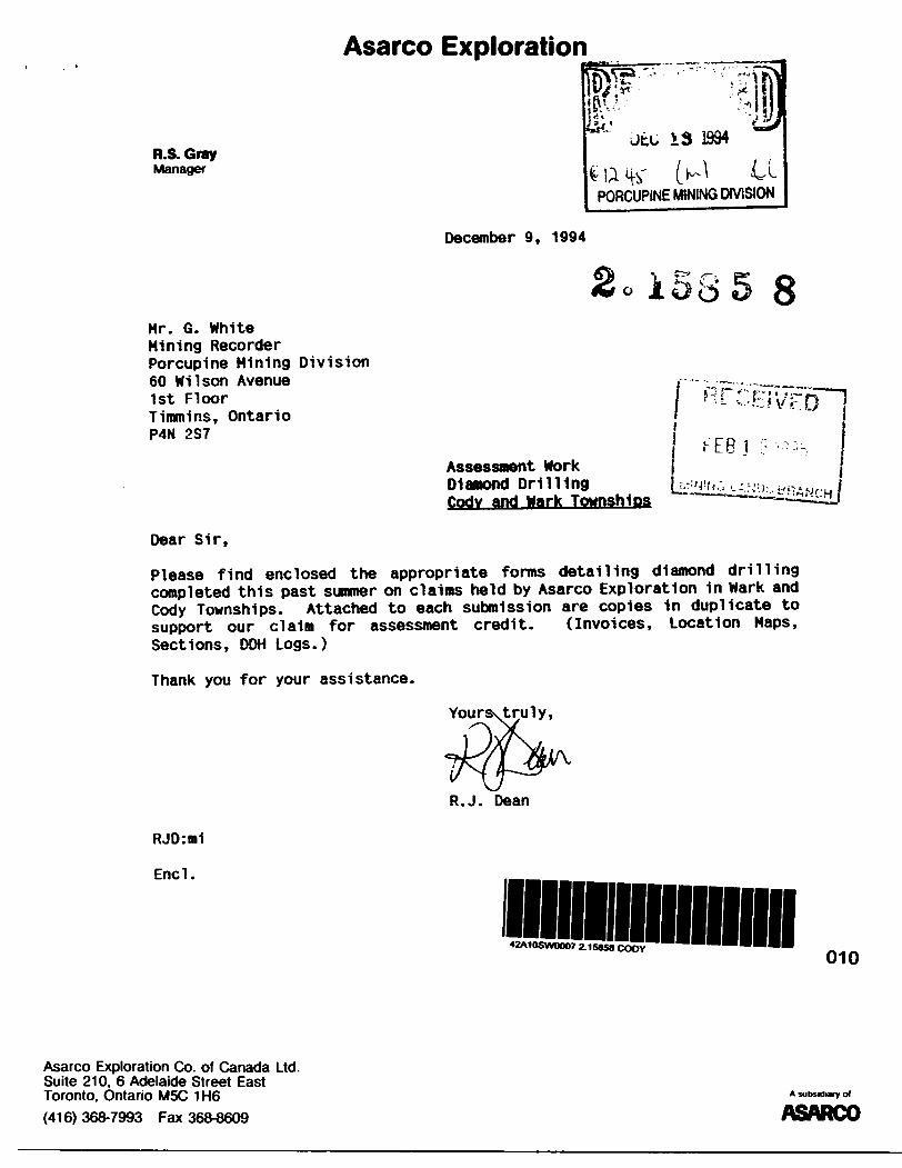
Asarco Exploration
R.S. GrayManager
Jtu 13 1994
PORCUPINE MINING DIVISION
December 9, 1994
Mr. G. WhiteMining RecorderPorcupine Mining Division60 Wilson Avenue1st FloorTimmins, OntarioP4N 2S7
Assessment WorkDiamond DrillingCody and Wark Townships
r'EBj
Dear Sir,
Please find enclosed the appropriate forms detailing diamond drilling completed this past summer on claims held by Asarco Exploration 1n Wark and Cody Townships. Attached to each submission are copies in duplicate to support our claim for assessment credit. (Invoices, Location Maps, Sections, DDH Logs.)
Thank you for your assistance.
Yours\truly,
R.J. Dean
RJO:mi
Encl.
010
Asarco Exploration Co. of Canada Ltd. Suite 210. 6 Adelaide Street East Toronto, Ontario M5C 1H6
(416) 368-7993 Fax 368-8609
A subsidiary o*
ASARCO
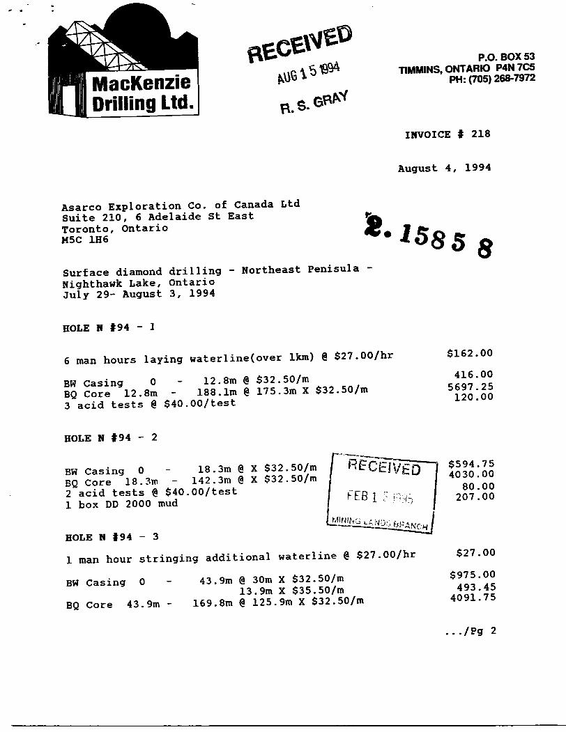
MacKenzie Drilling Ltd.
P.O. BOX 53TIMMINS, ONTARIO P4N7C5
PH: (705) 268-7972
INVOICE f 218
August 4, 1994
Asarco Exploration Co. of Canada Ltd Suite 210, 6 Adelaide St East Toronto, Ontario M5C 1H6
Surface diamond drilling - Northeast Fenisula -
Nighthawk Lake, Ontario July 29- August 3, 1994
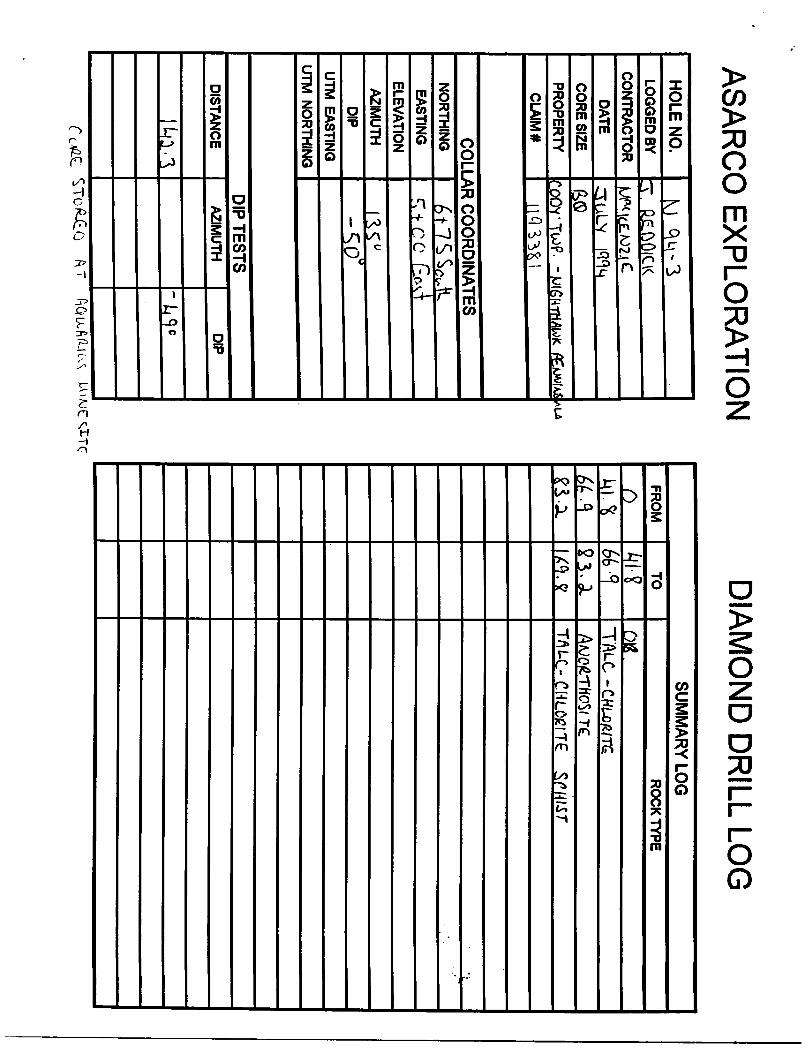
8
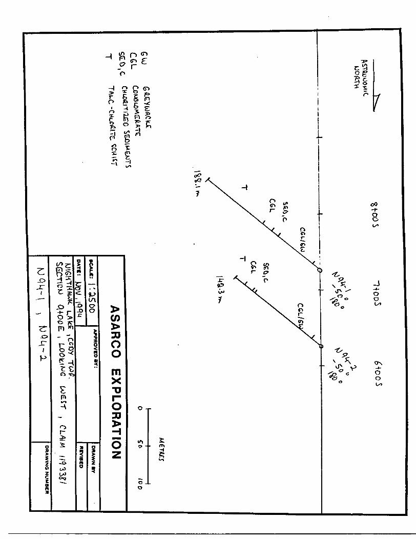
HOLE N t94 -
6 man hours laying waterline(over 1km) @ S27.007hr
BW Casing O - 12.8m @ $32.50/mEQ Core 12.8m - 188.1m @ 175.3m X S32.5Qfm
3 acid tests @ S40.00Xtest
$162.00
416.005697.25120.00
HOLE N 194 - 2
BW Casing O - 18.3m @ X S32.507m BQ Core 18.3m - 142.3m @ X $32.50/m
2 acid tests @ S40.007test l box DD 2000 mud
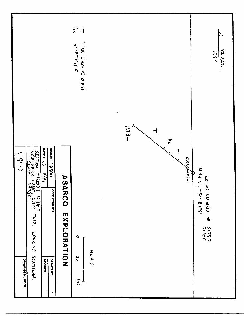
HOLE N |94 - 3
l man hour stringing additional waterline @ S27.007hr
BW Casing O - 43.9m @ 30m X S32.507m13.9m X SSS.SO/m
BQ Core 43.9m - 169.8m @ 125.9m X S32.507m
4030.0080.00
207.00
S27.00
$975.00493.45
4091.75
.../Pg 2
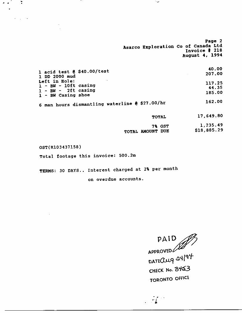
Page 2Asarco Exploration Co of Canada Ltd
Invoice f 218 August 4, 1994
l acid test @ S40.007testl DD 2000 mudLeft in Hole:l - BW - 10ft casingl - BW - 2ft casingl - BW Casing shoe
6 man hours dismantling waterline @ $27.00/hr
TOTAL
7% GST TOTAL AMOUNT DDE
40.00207.00
117.2544.35
185.00
162.00
17,649.80
1,235.49 S18,885.29
GST(R103437158)
Total footage this invoice: 500.2m
TERMS: 30 DAYS.. Interest charged at 2% per month
on overdue accounts.
CHECK No.
TORONTO OFFK5

Coo/ -aop.
AS
AR
CO
E
XP
LO
RA
TIO
N
North
east
Bay
ftf**o
rtj(00
(J.OO
AS
AR
CO
E
XP
LO
RA
TIO
N
SCALK: i . \O
OD
APPROVED BY:
DR
AW
N B
Y
RE
VIS
ED
UA
KE
G
"-lO
*- O
lAM
C^O
O
fiJLL
i , coov
TCO^.M
QM
-I .
MQ
M-J
/pq^-^
DR
AW
ING
NU
MB
ER
(\STftuO
O ̂
i C. O
OfO
-TH
CG
LC
C
HO
XHT.2JEO
too
AS
AR
CO
E
XP
LO
RA
TIO
N
: i-.asooO
ATC:
APPROVED BY:
DR
AW
N B
Y
RE
VIS
ED
DR
AW
ING
NU
MB
ER
CO
U-A
A.
C/U
S
fi.10S
T
-f
SO
AS
AR
CO
E
XP
LO
RA
TIO
N
SCALE: |'. 3.S
OO
OATB:
APPROVED BY:
l 00
DR
AW
N B
Y
RE
VIS
ED
CL/IIM
w 9 "rLAIkJC
, CO
OV
DR
AW
ING
NU
MB
ER
AS
AR
CO
EX
PLO
RA
TIO
ND
IAM
ON
D D
RILL LO
G
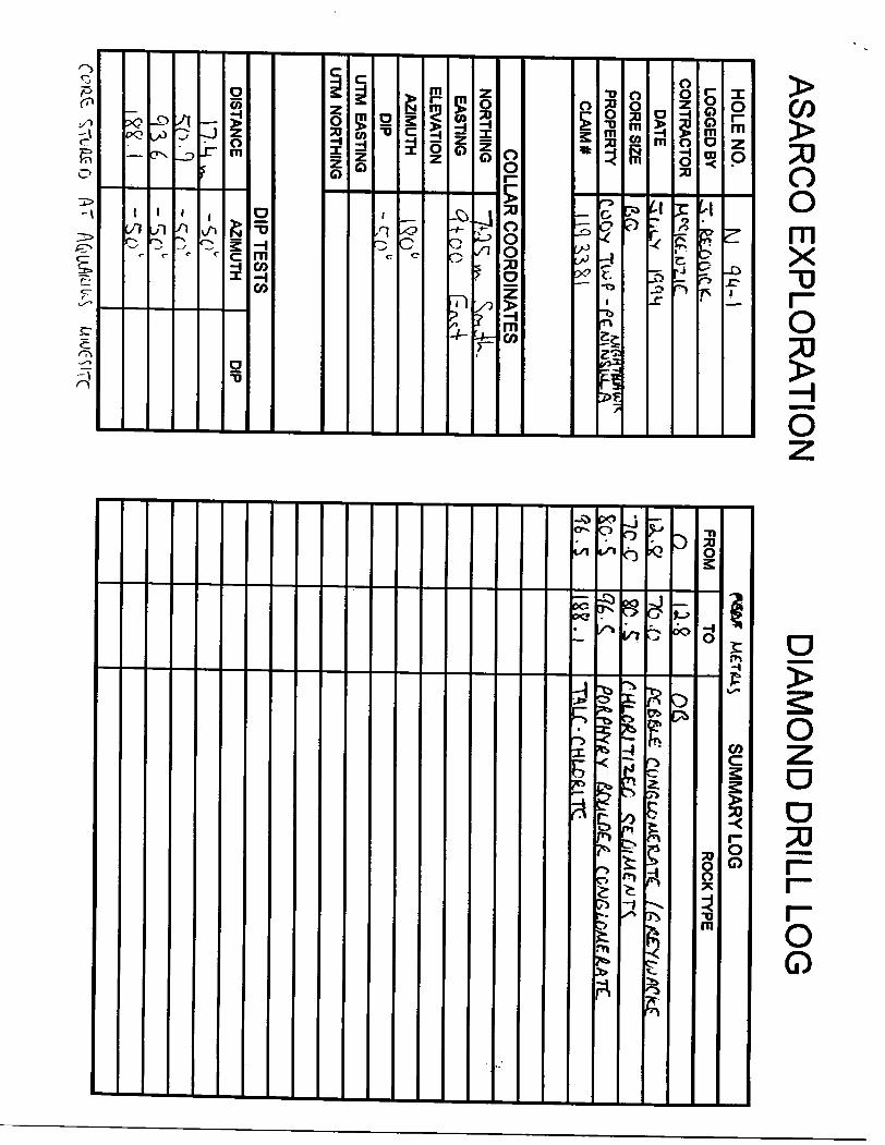
HO
LE N
O.
LOG
GE
D BY
CO
NTR
AC
TOR
DA
TE
CO
RE
SIZE
PR
OP
ER
TY
CLA
IM*
M
4^-
^.feJL
CiftiC
K..
K^lC
f-UL
lf
3iiu
V
lr-iriM
acC
oftv
TW
P-P
tAftK
iEr
nq
^^i
CO
LLAR
CO
OR
DIN
ATE
SN
OR
THIN
G
EA
STIN
G
ELE
VA
TION
AZIM
UTH
DIP
UTM
EA
STIN
G
UTM
NO
RTH
ING
7a^ ^ .^.4U.
^10
0
f^v^4
IQO
0
-crn"
DIP
TE
ST
S
DISTAN
CE
H.L
I^^0
.031.6
i&K
.I
AZIM
UTH
D
IP-so"-^
n"
- ^-S
o1
FRO
M
n
ne -cSo-S
TO
-to .tt80. S
. C(S
K. i
SU
MM
AR
Y LO
GRO
CK
TYP
E
CGMGLTJAF./LATZ
,Tt(lf O A

FRO
MTO
DESC
RIPTIO
NSAM
PLE*FROM
TOLENGTH
CHECK
0
"iy
f 4. l
" kiW
*'Lc
r W~Tk
Sov4
^ /J
Uk
T^N
. T
tt
S•y^y^
AM?
I-Q
•#•0HO
LE NO
.,PAG
EO
F \
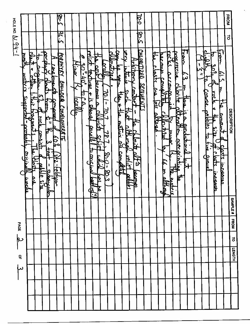
HO
LE N
O.
HO
LE NO.
ASARC
O EXPLO
RATIO
ND
IAMO
ND
DR
ILL LOG
HOLE NO
.LO
GG
ED BY
CONTRACTO
R
DATE
CORE SIZE
PROPERTY
CLA
IM*
(vjqq.^
:r.fUE.Goic.k.l lw
i/ c i n [fN
^ lv
j—^C
It-
3"UU
I^M
Gv
C&
til TWP.- MIGHTMAiAJfc ft^J/M
Sut^
1 |C| 3A9 1
COLLAR CO
ORDINATES
NORTHING
EASTING
ELEVATION
AZIMUTH
DIP
UTM EASTING
UTM NO
RTHING
f; 4- d.^
So J
L
Q t- r, h E^cx'si
Ift0u
-so6
DIP
TE
ST
S
DISTANCE
Oj.Lj
IM3L-"S
AZIMUTH
DIP5tt0
Si*
SU
MM
AR
Y LO
G
FRO
M
.i
us c
TO
//l. -7
RO
CK
TYP
E
CQ(U1

FRO
MTO
DESC
RIPTIO
NSAM
PLE 4FR
OM
TOLE
NG
TH
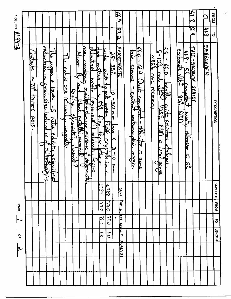
o
i"iav^.
trv
M
Mtl- l
J
17 /^ -
Vvs.iv. i
TrW
JTiL
nlA
LJtT
W
"l/w
P
"f)
TJX
(6-to C-Cs.
T- fK
.c*
44.7 T
LA,CC
I-C.
IK
TU
o&
ML
.9 -
(DM -7
'
r.VxA
** t K
. hv
xiv
jrfl
0 1 iQ
Ut—
fn
rQlfL
y
I 7n l A
yO
r
rv
HO
LE NO.
PAGE
l___
OF
3
ojfc- III, g
.(Q
. 3
fro* -ter A. L? .^flvxp
HO
LE N
O.
TOD
ESCR
IPTION
LENGTH
L&
Tto
L-C
Hl
^lostiy
C
ff/r
.AAi 1 0L
-.I IV
1.1 1
^(a.9.o
HO
LE NO
.PAGE
OF
ASARC
O EXPLO
RATIO
ND
IAMO
ND
DR
ILL LOG
HO
LE NO
.LO
GG
ED B
Y
CO
NTR
AC
TOR
DA
TE
CO
RE
SIZE
PR
OP
ER
TY
CL
AIM
*
|VI Q
U-3
T
fiEftOiC
KM
ft(ldfLM2.lC
^(,L
V
MM
&Q
roO
VT
WP
- -w
fiHtM
A*)lcflEw
wlA
|
llfl ^K
l
CO
LLAR
CO
OR
DIN
ATE
SN
OR
THIN
G
EASTIN
G
ELEVATIO
N
AZIM
UTH
DIP
UTM
EASTIN
G
UTM
NO
RTH
ING
l + m*,^
c + roricA-V
i^^^-W
DIP TE
STS
DIS
TAN
CE
lio.i
AZIM
UTH
D
IP
-L-q*
SUMM
ARY LOG
FROMOm.%
MA
friv
X
TOm-%^
c23.3
11/9.*
ROCK TYPE
Otf
TALC
-CHUWTG
AAJC&THCS/ TCTflLc- CHLORITE
srwwr
SToftJdo AT
riQu.fio.iw
HOLE NO
.
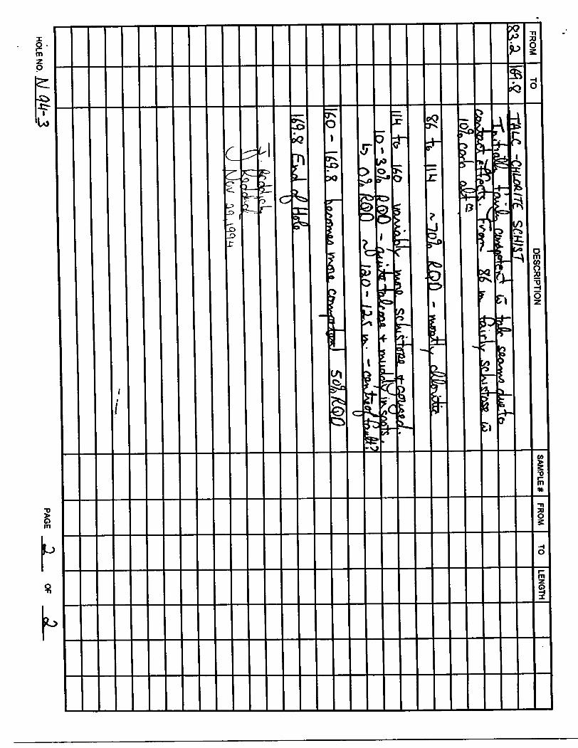
FROM
TOD
ES
CR
IPTIO
NS
AM
PL
E*
FRO
MTO
LEN
GTH
-TALC, -CHUAITC SCHIST
4b |iM
^"?ol
"b
f)0
O?*
/A0-
- - ea
^fao
J*LA?
Ifl.*Tr
O
HO
LE NO
. M
W
'3PA
GE
OF
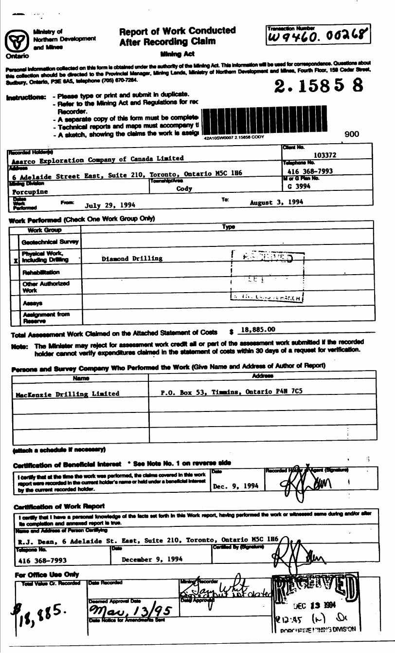
MMstry ofNorthern Development
Ontario
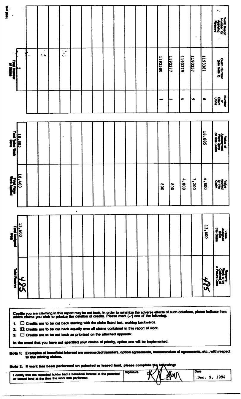
Report of Work Conducted After Recording Claim
on this form Is oblsJnsd under ttw emhorily of Bis MMng Act. TNs MonimMon tMHDSussdtarc
should be dhertsd lo the Prodndel Mmejsr. lining Lands. MMatry at Northern PKSlupmenl end Mnss. Fourth Floor. 188 Cedar are*.
P3E 6AS. Wephorw (70S) 670-7284.
type "print and submit hi- Refer to the MMny Act and flejulBUons for ree
Recorder.- A separate copy of this form must be complete- Technical reports and maps must accompany ttA m m, — m a ^hW^^k^J^h^B aeWd^ ^^^^1^*^^ asV^ A^p**eV ^sk ^^^^2^^
SKetcn, snowing me CHHIHS me wonc M mjsiyi
2-1585 8
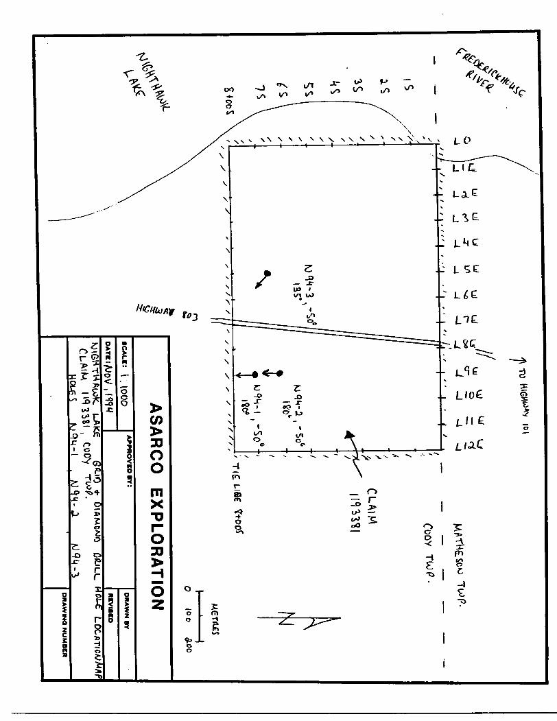
42A1OSW0007 2 15858 CODY 900
RscBnUtUM* Aff*rco Exploration Company of Canada Limited
6 Adelaide Street East, Suite 210,
Porcupine
Ptataimd FtOOC July 29, 1994
Toronto, Ontario HSC 1H6
Cody
CSMNo.103372Mwtamifc ——————————
416 368-7993U or Q PU Ho. ————— —————
G 3994
T" August 3, 1994
Woffc Performed (Check One Work Group Only)
WorkGroup
Z
Geotschnlcal Survey
1— ̂— MB-JI— fc-fc ff^eMk^M *mduang DfwnQ
R^abWatton
Other Authorized•AO^.^B-VVWK
AaaayaAealaninent noni
Type
Diamond Drilling | Ir :~~ '^ ~}*f^J} ~]j -J j
! - - i, 'L t i - :
———————————————————————————————————————————— |:.I.-..^..^J —————————————————————
Total Work Claimed on the Attached Statement of Costs S 18,885.00
NOSK The Mtnietsr may ro|oct for assessment work cfOdH al or part of the assessment work submitted if the recorded
holder cannot verify oxpondMuioo claimed in the statement of costs willrin 30 days of a request for verification.
and Survey Company Who Performed the Work (Give Name and AddroM of Author of noport)
JjlaiBMmiNtVM
Mackenzie Drilling Limited
Address
P.O. Box 53, Timmins, Ontario PAS 7C5
AAW 4 —-^- ——— — ——-no* i on twvfOT
ttottBf VMl fll VW ami*) ana)
MDOrtMraieooidsillntwcoMrad Inftto wocfc
by fw currsrt vsoonM hoMsr. Dec. 9, 1994
penon de* ol Hw fscls Ml lorth hi Ms Worti rafwrt. tawtng pwforaMd ON wortc orItolnw.
OUfatlQ aVvWOf WsW
R.J. Dean. 6 Adelaide St. Eaat, Suite 210, Toronto, Ontario M5C 1H6
For Office) Uee Only
O'AT
poor" PS: JP ? VMM'3 OWIS'OM
ti
- -a
H1
Ul
-v ,,
-
m.
e-
UI 00o
-
H-
j3
-
H-
3
-
^-
O W b)
-
^-
O*
ODl-*
ON
*-.
B|
iK !|
iH
il!
p00
OD ODUl
ODW
s 00o o
OD
3V
00o0
vj
loo o
00w00 O9Ul
9 ODg
S**1*1 frt-
Bfr
•i
V
i
•oCA
wwo*8
^^^^ Hv^j^w\
wm
1*9*
Cradfts you ant claiming hi this report may be cut back. In order to minimize ths adverse effects of such dotations, ptssas Mteaia from *Mch claims you wish to priorize the deletion of credits. Please mark f^) one of the Mowing;
1. D CrsdMs ara to bs cut back starting with the claim Rstsd test, working backwards.
2. O Credit* are to bs cut back equaty over al cfalms contained In this report of work.
3. LJ CredHs are to bs cut back as priortzed on the t
In ths event that you haws not specified your choice of priority, option one wal be implemented.
l:
2: H wotfc has been performed on
1 cert* ft* Hw raoontod hofcfcr had a or IssMd lend st *w Mw ttw work we
rdsd transfers, opt
in in* ptfwMdIMs Dec. 9, 1994
duduNord
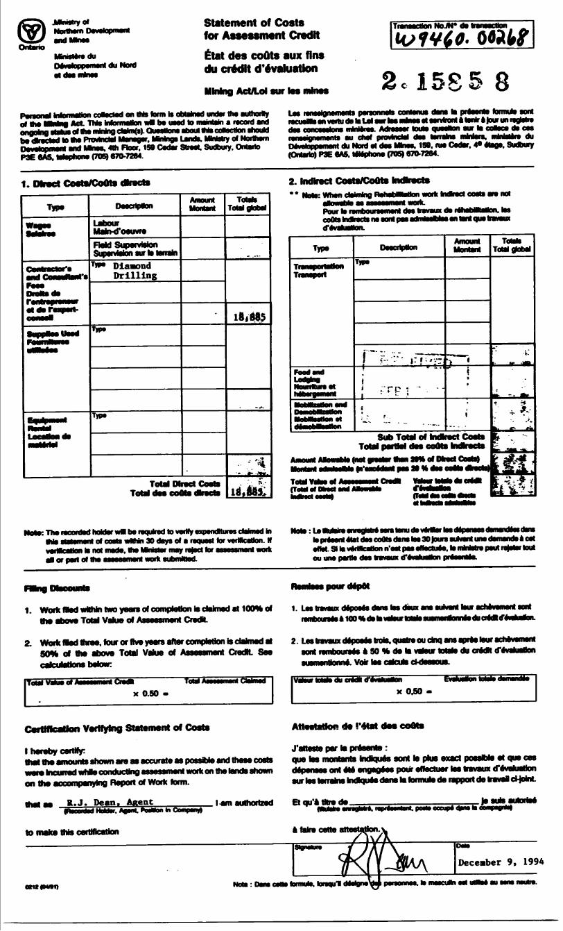
Statement of Costs for Assessment Credit
tlat des coOts aux tins du credit devaluation
Transaction NoJN* da
tO f VI J.
2.1585 8Pereonel of the
i coasctad on tMs form to obtainad undar tha authority LeaAct Thto toforrnalton wB ba uaad lo maintain a record and
l to aw Provincial Manager. MMngs LanoX MnMry of Northami Ftoor. 150 Cadar Straat. Sudbury. Ontario
P3E 6A5. wtopnona (705) 670-7264.
contonus dans to present* l an vertu da to Lei aar toe mhws et ssrvkont a ter* a Jour un ngtatre
aur to ceBece da ces du
DaVatopparmnt du Moid al daa Mkwa. 150. nw Cadar. 4* etoge. Sudbury (Ontario) P3E 6A5. wwnhons (705) 970-7264.
1. Dbvct Costs/CoOts dkact*
Type
MaJrMfoauvra
OaMtAM^^Mflfe MWsupsrvajRjn aurT** Diamond
Prilling
TIP*
Amount
Total Direct Total daa cotte
T) Total global
2. Indirect Costs/CoOtsA 0 M^AAB IMh^** d^^fav^MMnow? wnan cwviwig work ftndbsct costa am not
Pour to rafnbouraamaot coots Mbacta na aonl pi tfavabatton.
Sub Total of Indirect Costa
Near. The reoordad hoUarwM be raquked to verify axprndNurasctohnadta Now: tat idavMtortoatl of costs wMMi 30 days of a raquaat tor verification. M
i to not made, the MMster may reject tor assasamont work l of port of Ino ossossmsfal wwtc subfnittod.
to prtaant alat daa coots dam toa 30toura suwanl una damanda a cat
ou una partto daa travaux d*ev
pour depot
1. Work fled wWiin two yoon of the above Total Value
to claimed at 100* of CrerJL
1. Los liovoux dspooos dons too doux ono ramtaunia* lOOHdatowjtowtototoaui iducntdltfi
2. Work fladthrae, four or five year fleiof the above Total Value of
calculations below:
4etton is claimed at CredK. Sea
Total Vahw of l ToM M lCtobi
x 0.50 -
2. Lastravauxdftpoa68troto.Quatreou dnq ansapres touracnavemant aont lembouraaa * SO H da la vawur totato du credH tf evataflon auamenaonne. Voir toe cateuto d-uaaanm.
Cywuallon lota
x 0.50 -
Catttflcation Verifying Statement of Costs
l hereby certify:that tha amounts shown are aa accurate as p
t Incurred wtwa conducting assessment work on the lands shown on the aocompanyinQ Deport of Work forrn.
that aa R. J. Dean, Agent
qua tos moiitants kirjqiiaa aont la plus exact poaaMa at qua on depenses ont Ms engegees pour eftectuer tea travaux d'avafuatton aur las terrains kwiques dana la formuto de rapport de travel cHokiL
.( am authorized Et qu'atHrede.
to make this certmcatio a take cette
December 9, 1994
otuawaq Not*: Dana oaaa fomww. knqul iHilgni\
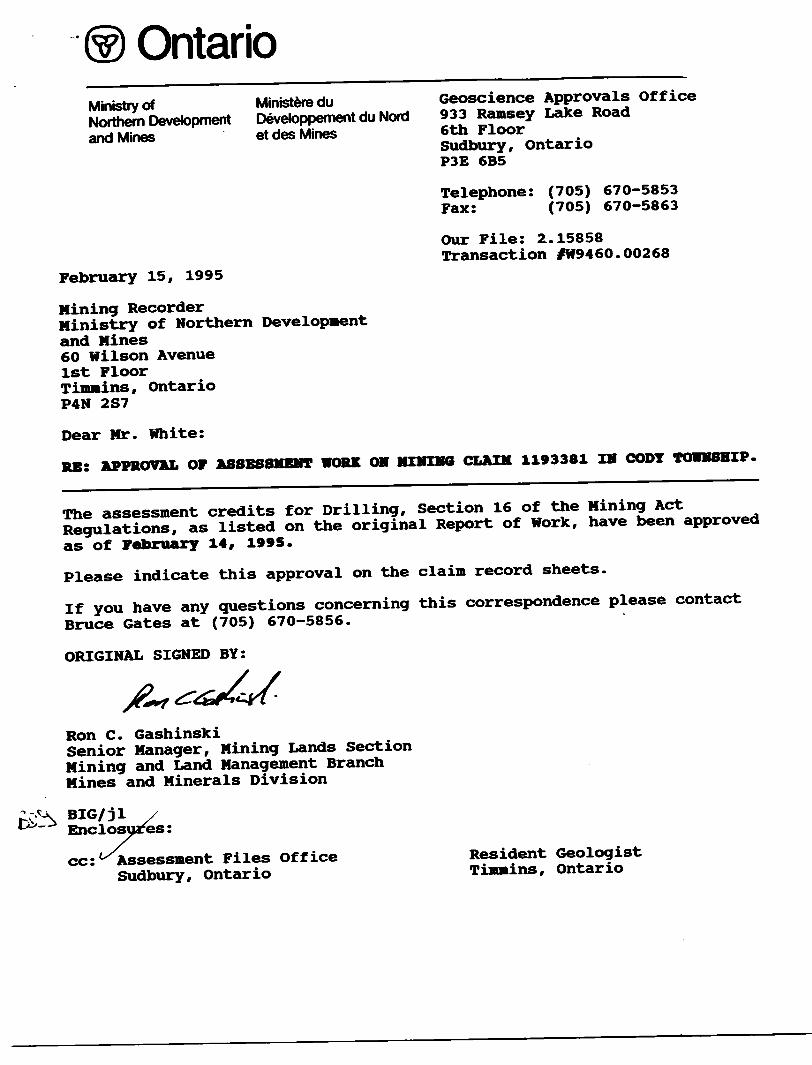
OntarioMinistry of Ministere du Geoscience Approvals Office
Northern Development Developpement du Nord 933 Ramsey Lake Road
and Mines et des Mines 6th FloorSudbury, OntarioP3E 6B5
Telephone: (705) 670-5853 Fax: (705) 670-5863
Our File: 2.15858 Transaction fW9460.00268
February 15, 1995
Mining RecorderMinistry of Northern Developmentand Mines60 Wilson Avenue1st FloorTimmins, OntarioP4N 2S7
Dear Mr. White:
RE: APPROVAL OF ASSESSMENT WORK ON MIMING CLAIM 1193381 IN CODY TOWNSHIP.
The assessment credits for Drilling, Section 16 of the Mining Act
Regulations, as listed on the original Report of Work, have been approved
as of February 14, 1995.
Please indicate this approval on the claim record sheets.
If you have any questions concerning this correspondence please contact
Bruce Gates at (705) 670-5856.
ORIGINAL SIGNED BY:
Ron C. GashinskiSenior Manager, Mining Lands Section Mining and Land Management Branch Mines and Minerals Division
BIG/jl Enclosures:
cc : Assessment Files Office Sudbury , Ontar io
Resident Geologist Timmins, Ontario
MAP SYM9QLOGY
Aerial Cableway
Boundary
l itarnoliono*
inttrprovinciol
District, To*nihip
Indian fttttrvt
Approftlmotf
park Boundary
Bridge
Mood, Railroad
Building
Chimney
Cliff, Pit,Pile
Contours
Diprtltion
Control Pointt
Horizontal
vertical
Culvert
FallsDoubla lint river
Fence, H edge, Wall
tt 01774051
O 300 02
Feature Outline[Construction f tatur
.1C )
Flooded LandLock -^Marsh or Swamp ^jMast i,':-
Mine Head Frame aOutcrop •...--
Pipeline(obovt ground)
Rai l roadSingia Track
iluuDI t T ract
Abandon* d
T uritoblt
RoadHi jn*ay . Count y
To *nlhi p
ACLtsi (load of doughtful mainttnonca or ~ ~ ~ ~"
ign'licant dnvivay)
(portaft ail ty )
RapidsJoubla lino river vim multiple ropldi
Ocukltliixrivrr ( -\Rltpidi ml* nullIcK rapid! \ Y
Retervoir p**"y r
River, Stream, Canal
-Irtction of flo* ^-^-^—^
Kockiijnificant -r
- hoalSpot Elevation
(luti iltvationi) '30OO
Tower a *
Transmission Line
PoKl Pylon*
Tunnel
Utility Poles * Wharf , Dock, Pier
Wooded A raa
C—
AREAS WITHDRAWN FROM DISPOSITION
M.R.O. - MINING RIGHTS ONLY
S.R.O. - SURFACE RIGHTS ONLY
M.+ S. - MINING AND SURFACE RIGHTS
Description Order No. Date Disposition Fill
W 53/76 10/9/76 S R O 16539
(UP) APPLICATION PENDING UNDER PUBLIC LANDS ACT v——J NOTICE RECEIVED 93-MAR-30
(SNOWMOBILE TRAIL)
, HIS TWP IS SUBJECT TO FOREST ACTIVITY IN r' ' FUPTI )FP INFORMATION AVAILABLE OW FILE.©
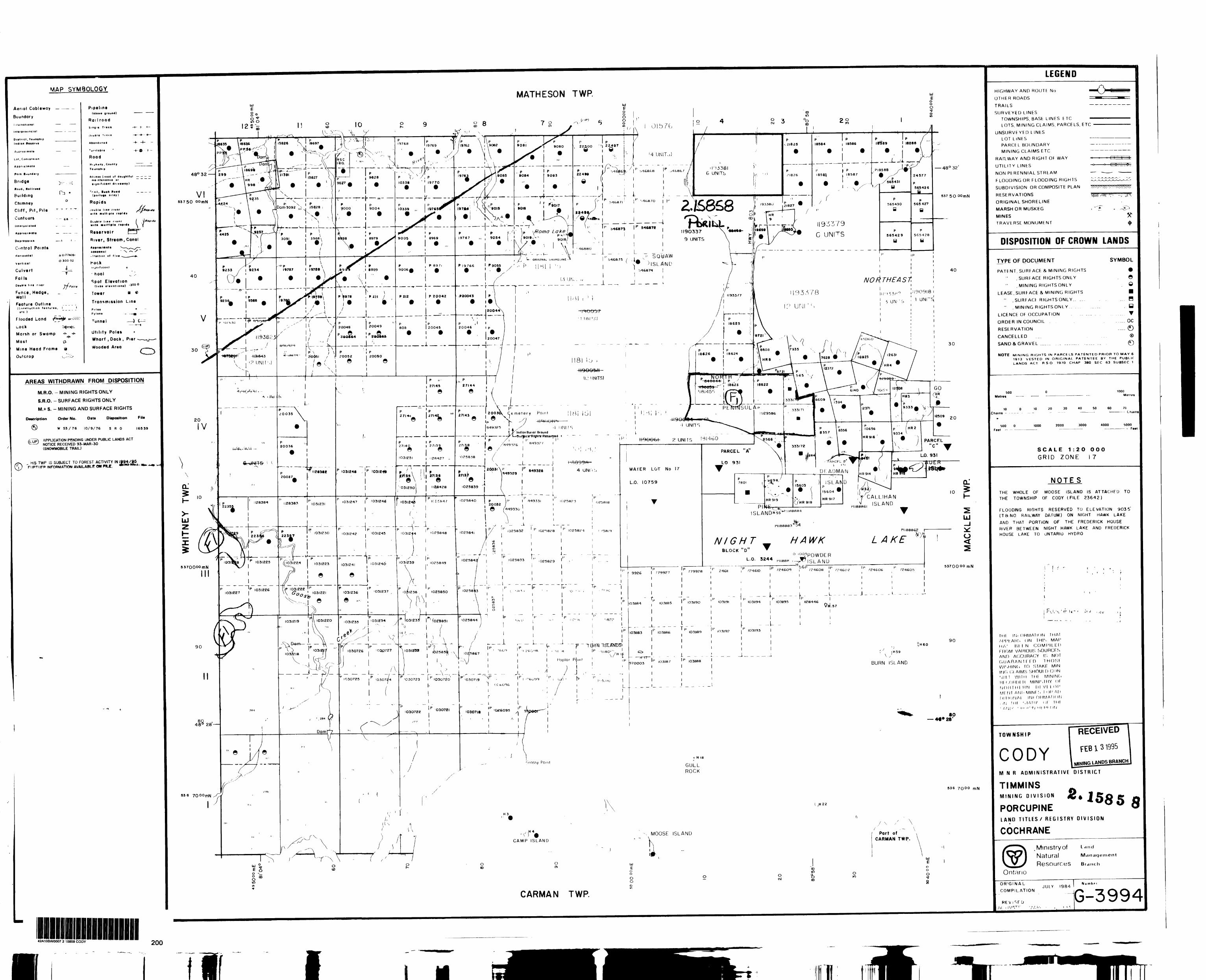
42A10SW0007 2 15858 CODY 200
MATHESON TWP.
480 32
53750 oomN 2..&&S8
\ si f \-~t-~J\t\ i 'l . l
20044X~~-r-i——-•H— - — ——-A- -*
' l l
i.....200S(\ Cemetery Poml
l e Xl r-'-'-'- - \ l. ' ' J l
l i J Indian Burial Ground —— — — ——' T""—"" ~ •TrT-i:9iirtpc*rflrgrifi-RwMrrid r —
'P A i- f
- - -L . - ___ ,
•i—p——k l K-JE&4?
———^^r —' - -r ' i ryMp^n
" i P~ ~ ^~ ^
(fl03l2E4 1031223 —^ l
l 7 d ^ 7
—— 48 0 32
537 50 oo m N
40
30
r !p
i.-
r-p
"P
lf
i
-
L
IM ' l '' ' M3Q/1
•1 UNITS
tiQOQGf- ? UNI I S
WATER LOT No 17
L.O. 10759
T
'p ip9926 1 .'79927 , "9928
1
1
1
IO3II84 ^ IOJII85 IO3II9O
1
1- - - , p ~ ~ " ~ TP' ~IO3II83 1 IO3IIB6 IO3IIB9
1 1
1 1
- — H-T7— | - - f - - -970OO3 lOAIIB/- I P IO3II8B
1 1
1 1
1 1
' - - - '- - - ~ J - - -
5331 n |B \ 1029586 ' \
e*a^. m \
^*^~**^*^ p 1 H- — — — — ^MM^ •HiK^E^tdESX.^^y 9̂ ^^^^*~^ 8 357
61460 ^^see ; .. p ' ^ •^. 9 333I7H
PARCEL "A" \ - . , ,\ •' 'IB* 84 s*'~Vim
LO 931 \ - ' --rm-cFLW \ T DF. AD M /3
, V' '^03 ) 'SLAN
B ' l l 5604HR9I9 " /V ' HR9I7
r /HR 918P NE
ISLAND" -55 *H " a8flM
NIGHT HAWKBLOCK "D" V
O l OOi pQ\A/ QF R
L.O. 3244 P ||88P ,^| SLANU H
IP ip jp bbp ip i 24611 i ^?46IO ' ^24609 i ^?46O8 { r rf\l
1 III
1 ' 1 1 |
1 , 1 1 1
i P ~ 1 P "" ~ ~ P 'P 1IO3II9I . IO3II94 1 IO3II95 . II2B446
i i i i r"i i i i i1 1 L i '' P 103119? | P 1031193 1
' 1 '
1 1 1
1 1 1
T ~~" — - - — ~--iii
- — :
\A, VCALLIHAN v
PII88BG2
LAKEl J y
P /24606
UJ-l x. o
5370000 mN
90
V)H59
BURN ISLAND
•O 28'
a H 16
GULL ROCK
536 7QOO mN
H22
•" vMOOSE ISLAND
y \ s ' \
Part of CARMAN TWP.
oCM
fc00
o10
o oo
CARMAN TWP.
fi I l lfc
LEGEND
HIGHWAY AND ROUTE No
OTHER ROADS
TRAILS
SURVEYED LINESTOWNSHIPS. BASE LINES ETC
LOTS. MINING CLAIMS. PARCELS, ETC
UNSURVEYED LINES
LOT LINESPARCEL BOUNDARY
MINING CLAIMS ETC
RAI'LWAY AND RIGHT OE WAY
UTILITY LINES
NON PERENNIAL STREAM
FLOODING OR FLOODING RIGHTS
SUBDIVISION OR COMPOSITE PLAN
RESERVATIONS
ORIGINAL SHORELINE
MARSH OR MUSKEG
MINES
TRAVERSE MONUMENT
DISPOSITION OF CROWN LANDS
TYPE OF DOCUMENT
PATENT, SURFACE 81 MINING RIGHTS
.SURFACE RIGHTS ONLY
. MINING RIGHTSONLY
LEASE.SURFACE 81 MINING RIGHTS
" .SURFACr RIGHTSONLY,, ...
" . MINING RIGHTSONLY ,
LICENCE OF OCCUPATION
ORDER IN COUNCIL .
RESERVATION
CANCELLED
SAND 8. GRAVEL ..... . ....... ,.
SYMBOL
9. e
e
Hy T
oc
NOTE MINING RIGHTS IN PARCELS PATENTED PRIOR TO MAY 6
1913 VESTED IN ORIGINAL PATENTEE BY THE PUBLIC
LANDS ACT RSO 1970 CHAP 38O SEC 63 SUBSEC 1
SOOMetres
10 O Chains - - - - - -
1000Metres
10 20 30 40 50 60 70Chain*
SOO O 1000 2000 3000 4000 5000 Feel - - ———————— ———————— ——————— - Feel
SCALE 1:20 000
GRID ZONE 17
NOTESTHE WHOLE OF MOOSE ISLAND IS ATTACHED TO
THE TOWNSHIP OF CODY (FILE 23642)
FLOODING RIGHTS RESERVED TO ELEVATION 9O3 5' (TaNO RAILWAY DATUM) ON NIGHT HAWK LAKE
AND THAT PORTION OF THE FREDERICK HOUSE
RIVER BETWEEN NIGHT HAWK LAKE AND FREDERICK
HOUSE LAKE TO ONTARIO HYDRO
FU.'v'.r
JHI IN* OHMAMOIM THAI AI'f'KAHS ON THIS MAC HA' RI l N COMPILED FROM VARIOUS SOURCES AND ACCURACY IS NOT GUARANTEED 1HOSF WI'.HINd fO STAKE MINING ci AIMS snout D CONSill I WIIH IMF MININC. RI t.ORDI R MINISIRY Of NOR l Ml RN DI VI 101' MF NT AMI ' MINf S f OR Al lDI i IONAI INI ORMAT K IN. , ti l HI ' iIM l l' Of" T HI ' /,rj[ r -H' ii' T J Ht Ml ( IN
TOWNSHIP
CODYRECEIVED
FEB l 3 1995; l &NDS BRANCH
MMR ADMINISTRATIVE DISTRICT
TIMMINSMINING DIVISION
PORCUPINELAND TITLES/ REGISTRY DIVISION
COCHRANE
.Ministry of Natural Resources
L a fi ci
Management
Blanch
Ontario
ORIGINAL
COMPILATIONJULY 1984
N u mh f f
jG-3994
~ " ""' "TWT'll