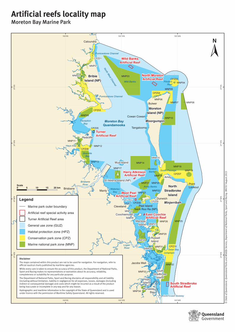
artificial reefs locality map - department of national ... · title: moreton bay marine park...

1
153°30'E 153°30'E 153°15'E 153°15'E 153°0'E 153°0'E 27°0'S 27°0'S 27°15'S 27°15'S 27°30'S 27°30'S 27°45'S 27°45'S Wild Banks Artificial Reef Turner Artificial Reef North Moreton Artificial Reef Harry Atkinson Artificial Reef West Peel Artificial Reef East Coochie Artificial Reef South Stradbroke Artificial Reef Moreton Island (NP) Moorgumpin Moreton Bay Quandamooka North Stradbroke Island Minjerribah Bribie Island (NP) MNP32 MNP30 MNP31 MNP34 MNP33 MNP25 CPZ10 MNP28 MNP27 MNP26 MNP29 MNP21 MNP16 CPZ07 CPZ09 MNP24 MNP18 MNP19 MNP22 MNP23 MNP20 CPZ08 MNP14 MNP10 MNP15 MNP17 MNP13 MNP11 CPZ05 MNP09 CPZ02 CPZ06 MNP12 CPZ04 MNP05 MNP07 CPZ03 MNP03 MNP02 MNP01 CPZ01 MNP08 MNP04 MNP06 Flinders Reef Deception Bay Bramble Bay Hays Inlet Waterloo Bay Raby Bay Jumpinpin Gold Coast Seaway Moreton Banks Wild Banks Amity Banks South Passage Swan Bay Pumicestone Channel Pumicestone Channel North West Channel Brisbane River Logan River Cowan Cowan Bulwer Dunwich Amity Point Lookout Hope Island Cleveland Brisbane Caloundra Redcliffe Manly Jacobs Well Runaway Bay Tangalooma South Stradbroke Island Russell Island Macleay Island Peel Island Teerk Roo Ra (NP) Coochiemudlo Island Mud Island St Helena Island (NP) Artificial reefs locality map Moreton Bay Marine Park © State of Queensland. Queensland Parks and Wildlife Service, Department of National Parks, Sport and Racing. MA707 August 2015 5 10 15 20 km Scale 0 Legend Marine park outer boundary Artificial reef special activity area Turner Artificial Reef area General use zone (GUZ) Habitat protection zone (HPZ) Conservation park zone (CPZ) Marine national park zone (MNP) Disclaimer The maps contained within this product are not to be used for navigation. For navigation, refer to official nautical charts published by maritime agencies. While every care is taken to ensure the accuracy of this product, the Department of National Parks, Sport and Racing makes no representations or warranties about its accuracy, reliability, completeness or suitability for any particular purpose. The Department of National Parks, Sport and Racing disclaims all responsibility and all liability (including without limitation, liability in negligence) for all expenses, losses, damages (including indirect or consequential damage) and costs which might be incurred as a result of the product being inaccurate or incomplete in any way and for any reason. Hydrographic and maritime information is the copyright of the State of Queensland and is used under licence with the permission of Maritime Safety Queensland. All rights reserved.

Upload: duongnhi

Post on 17-Aug-2018

219 views

Category:

Documents


0 download

TRANSCRIPT

153°30'E

153°30'E

153°15'E

153°15'E

153°0'E

153°0'E

27°0

'S

27°0

'S

27°1

5'S

27°1

5'S

27°3

0'S

27°3

0'S

27°4

5'S

27°4

5'S

Wild BanksArtificial Reef

TurnerArtificial Reef

North MoretonArtificial Reef

Harry AtkinsonArtificial Reef

West PeelArtificial Reef

East CoochieArtificial Reef

South StradbrokeArtificial Reef

MoretonIsland (NP)

MoorgumpinMoreton BayQuandamooka

NorthStradbroke

Island

Minjerribah

BribieIsland (NP)

MNP32

MNP30MNP31

MNP34

MNP33

MNP25

CPZ10

MNP28

MNP27MNP26

MNP29

MNP21

MNP16

CPZ07

CPZ09

MNP24

MNP18

MNP19

MNP22MNP23

MNP20

CPZ08

MNP14

MNP10

MNP15

MNP17

MNP13

MNP11

CPZ05

MNP09

CPZ02

CPZ06MNP12

CPZ04MNP05

MNP07

CPZ03MNP03MNP02

MNP01

CPZ01

MNP08

MNP04

MNP06

FlindersReef

DeceptionBay

BrambleBay

Hays Inlet

WaterlooBay

Raby Bay

Jumpinpin

Gold Coast Seaway

MoretonBanks

Wild Banks

Amity Banks

South Passage

Swan Bay

Pumicestone Channel

Pumicestone Channel

North West Channel

Brisbane River

LoganRiver

Cowan Cowan

Bulwer

Dunwich

Amity

PointLookout

HopeIsland

Cleveland

Brisbane

Caloundra

Redcliffe

Manly

Jacobs Well

RunawayBay

Tangalooma

SouthStradbroke

Island

RussellIsland

MacleayIsland

Peel IslandTeerk Roo Ra (NP)

CoochiemudloIsland

Mud Island

St Helena Island (NP)

Artificial reefs locality mapMoreton Bay Marine Park

© S

tate

of Q

ueen

slan

d. Q

ueen

slan

d Pa

rks

and

Wild

life

Serv

ice,

Dep

artm

ent o

f Nat

iona

l Par

ks, S

port

and

Rac

ing.

MA7

07 A

ugus

t 201

5

5 10 15 20 kmScale0

Legend

Marine park outer boundary

Artificial reef special activity area

Turner Artificial Reef area

General use zone (GUZ)

Habitat protection zone (HPZ)

Conservation park zone (CPZ)

Marine national park zone (MNP)

Disclaimer

The maps contained within this product are not to be used for navigation. For navigation, refer to official nautical charts published by maritime agencies.

While every care is taken to ensure the accuracy of this product, the Department of National Parks, Sport and Racing makes no representations or warranties about its accuracy, reliability, completeness or suitability for any particular purpose.

The Department of National Parks, Sport and Racing disclaims all responsibility and all liability (including without limitation, liability in negligence) for all expenses, losses, damages (including indirect or consequential damage) and costs which might be incurred as a result of the product being inaccurate or incomplete in any way and for any reason.

Hydrographic and maritime information is the copyright of the State of Queensland and is used under licence with the permission of Maritime Safety Queensland. All rights reserved.