architectural, facies, and depositional...
TRANSCRIPT
ARCHITECTURAL, FACIES, AND DEPOSITIONAL ENVIRONMENT ANALYSIS
OF PALEOGENE TO NEOGENE DEPOSIT IN THE NORTHERN OMBILIN
BASIN: IMPLICATION HYDROCARBON POTENTIAL
ANALISIS ARSITEKTUR, FASIES DAN LINGKUNGAN PENGENDAPAN PADA
ENDAPAN PALEOGEN HINGGA NEOGEN DI CEKUNGAN OMBILIN BAGIAN
UTARA: IMPLIKASI TERHADAP POTENSI HIDROKARBON
Ray Diwatra Linggadipura1*, R. Edo Fernando1, Muhammad Hafiz Prasetyo1, Avi Krestanu1,
Muhammad Addiansyah1, Budhi Kuswan Susilo2
1 Undergraduate Student at Geological Engineering Study Program of Sriwijaya University 2 Lecturer at Geological Engineering Study Program of Sriwijaya University
Jl. Srijaya Negara, Bukit Lama, Palembang, Sumatera Selatan 30128, Phone: (0711) 580739, Fax: 0711-
580741
Corresponding Author: [email protected]
ABSTRACT : Ombilin Basin is located in the intramontane zone with hydrocarbon potential.
Sangkarewang, Sawahlunto, Sawahtambang dan Ombilin Formation are the subjects of the
research. Literature study, geological mapping, studio and laboratory analyses which included
reservoir, geochemical, granulometry, petrography, and pollen analysis were methods used to
interpret the architectural and facies analysis. The Sangkarewang Formation is deposited in the
lacustrine environment through suspension mechanism which consists of oxic and anoxic
facies. Sawahlunto Formation is deposited by saltation mechanism, thus it is dominated by fine
fraction deposits which indicates the fluvial environment (meander river), it consists of
overbank, point bar and channel facies with sand bed form, and overbank fines architecturals.
Sawahtambang Formation is deposited in a fluvial environment (braided river) through bedload
mechanism. The facies of this formation are channel and overbank facies with channel, sand
bed form, and gravel bars architectural. Ombilin Formation is deposited in the marine
environment through suspension current which facies are pro delta, delta front and flat tidal.
The hydrocarbon system in the Ombilin Basin consists of Sangkarewang Formation as the
source rock with thick black shale lithology and papery shale structure. The hydrocarbon
migration consists of primary and secondary migrations. Sawahlunto Formation and
Sawahtambang Formation have potential as reservoirs. Sawahtambang Formation has excellent
porosity classification (27% -29%) and permeability value amount 183-284 mD. The traps of
hydrocarbon system are Koto Gadang anticline and Sawahluar fault. Ombilin Formation
consist of very thick of impermeable layer is potential as a seal. Further research in Ombilin
Basin is required to prove hydrocarbon potential.
Keywords: Architectural, Sedimentation Facies, Hydrocarbon, Ombilin Basin
INTRODUCTION
Background
Detailed research on Tertiary strata of Ombilin Basin is great for study, especially of the
Paleogen to Neogen deposit. Research area are located on the nothern Ombilin Basin were
focused pada Formasi Sangkarewang, Formasi Sawahlunto, Formasi Sawahtambang dan
Formasi Ombilin (Figure 1). Architectural analysis, facies and depositional environments are
helpful in interpreting potential hydrocarbon implications on ombilin basins in the study area.
Architectural methods is a technique that uses data derived from outcrop profile with
attention to the details of the components and the basis of the reasoning in the form of two and
three dimensional an outcrop (Miall, 1996 within Fernando, et al., 2017). An architectural
element may be defined as a component of a depositional system small or equivalent and larger
than an individual facies unit fill the place, characterized by a distinctive facies assemblage,
internal geometry, and same external form, furthermore architectural element are amenable to
descriptive and genetic classification as are their component lithofacies (Miall, 1996 within
Fernando, et al., 2017).
Facies are a body of rocks that can be identified and distinguished by other rock units on
the basis of geometry, lithology, sedimentary structures, fossils and patterns of its ancient
currents (Selley, 1985). Facies are generally grouped into facies associations that are
genetically related so that facies associations have meaning as environment.
The deposition environment is a part of the earth's surface where physical, chemical, and
biological processes differ from the region adjacent to it (Selley, 1988). Nichols (2009), adding
that the deposition process is a process that takes place during the process of formation,
transport, and sediment deposition.
Geologi Regional
Geologically the Ombilin Basin is a Tertiary basin located in a mountainous hill zone or also
called intramontane basin bounded by Pre-Tertiary rocks at the edge of the basin. The Ombilin
Basin lies in the Magmatic arc of the Barisan Mountains and the process of formation is
strongly influenced by the strike slip fault of Sumatra with the south-east orientation associated
with second-order descent of thrust and normal faults forming the graben structure
(Koesomadinata and Matasak, 1981).
Tectonic Regional
Techtonophysiographically, the Ombilin Basin lies between the current volcanic arc of the
western and non volcanic Barisan Mountains in the eastern Range Mountains (Figure 2).
Ombilin basin is also controlled by active faults in the boundary division of the Takung Fault
which is oriented WNW-ESE in the north-east and the NW-SE Oriented Fault System in
Southwest (Noerardi et al., 2005).
The Evolution of Ombilin Basin is tectonically inseparable from regional tectonic
mechanisms in the tectonic development scale of Southeast Asia, such as the Indian movement
of the block towards the north which eventually with the Eurasian continent by forming the
Himalayas, the Extrusion Concept of Tapponnier (1986), Woyla microplate with oceanic
composition as the basement of the Ombilin Basin, the development of the Sumatran Fault
System, the direction and speed of the Indo-Autralia plate convergence to the West-South side
of the Eurasian plate, the rotation of Sumatra Island, the open Andaman Sea all of which form
back arc basin patterns in Sumatran basically of each other is identical as well as the Ombilin
Basin. The Woyla landscape formed in the western part of Sundaland during the Mesozoicum
End and formed a clear boundary against the Mergui microplate (Pulunggono and Cameron,
1984). Therefore the Ombilin Basin is diverted by two types of microplate microplate
continental mergui in the northeast of the basin and the Woyla microplate oceanic in the
southwest (Situmorang et al., 1991).
Based on the genre of the Ombilin Basin is a pull apart basin, graben extends from the
south of Solok to northwest through Payakumbuh with a length of about 120 km and on the
southern part of the graben basin covered by volcanic rocks from Quaternary to Resent from
Malapi Volcano, Merapi, Maninjau and Singgalang (Yeni, 2011). The compression is the
product of subduction of the Indian-Australian plate under Sundaland, subduction begins in the
Early Middle Eocene and creates an extensional tectonic regime that forms several grabens
along the back arc tectonic setting (Yeni, 2011). The first asymmetric graben on the Ombilin
Basin occurs as a result of the Tertiary Strike-slip fault of the Sumatran Fault system which
then continues the dextral fault movement along the NW-SE direction forming the next graben
(Situmorang et al., 1991).
Stratigraphy
Sedimentary rocks in the Ombilin Basin are aged from paleogene to Pliocene, consisting of
sedimentary lakes, swamps and fluviatil deposits, as well as marine sediments. The
sedimentary rocks are lined by Pre-Tertiary rocks that are uncomfortably covered by Tertiary
sediments starting from the age of the Paleogene (Figure 3). In particular, this study focused
on the Sangkarewang Formation, Sawahlunto Formation, Sawahtambang Formation and
Ombilin Formation.
The Sangkarewang Formation is the oldest Tertiary sedimentary rock in the Ombilin
Basin (Silitonga and Kastowo, 1973; Koesomadinata and Matasak, 1981; Koning, 1985; Moss
and Howells, 1996). The Sangkarewang Formation has a facies relationship to the Brani
Formation. The Eocene of Sangkarewang Formation is a lake sediment consisting of
sandstones and dark gray claystone. Based on the results of pollen analysis in the
Sangkarewang Formation, it is estimated that the early Eocene (Koning, 1985), early Eocene
(Yarmanto and Fletcher, 1993) (Figure 2.4).
The Sawahlunto Formation consists of river deposits and red, green and purple
floodplains, consisting of rocks and shales associated with sandstone deposits, and lined with
layers of precipitated coal at Eocene age. Coal layers are thickness of 15 meters and economic
value (Moss and Howells, 1996). According to Koning (1985), said the Sawahlunto Formation
has an unrelated relationship to the top and bottom of the Sawahlunto Formation. The
deposition enviroment of the formation is interpreted as a meander river system with a number
of lakes around the river channel (Koesomadinata and Matasak, 1981). The hiatus process was
found exposed in several places and as evidence of a lack of coherence on several seismic
sections on the edge of the basin. The thickness of Sawahlunto Formation reaches 274 meters
(Kosoemadinata and Matasak, 1981), whereas according to Koning (1985), based on the
wellbore, this formation has a thickness of 170 meters.
According to Koesomadinata and Matasak (1981), the Sawahtambang Formation is
characterized by a thick, massive sequence of sandy sandstone. The shale and the rocks are
growing locally. Sandstones are light gray to brown, fine grained to very coarse, mostly
conglomerate with quartz sized gravel fragments, very poorly sorted, cornered, hard and
massive. At the bottom of the formation there are inserts of layers of clay or shales of siltstone
and forming a separate unit of the Rasau. Meanwhile, at the top of this formation there are coal
deposits that occur locally and form their own units, namely Poro Members. The age of the
Sawahtambang Formation is Oligocene (Koesomadinata and Matasak, 1981; Koning, 1985;
Yarmanto and Fletcher, 1993; Moss and Howells, 1996). According to Koesomadinata and
Matasak (1981), Sawahtambang Formation has a thickness of between 625 meters to 825
meters, and indicates the occurrence of thickening from north to south basin.
The younger and rising units aligned above Members of the Lower Ombilin Formation are
Members of the Ombilin Formation (Silitonga and Kastowo, 1973) also known as the Ombilin
Formation (Koesomadinata and Matasak, 1981; Koning, 1985). This Ombilin Formation
reaches 1400 meters thick, consisting of marine sediment in the form of gray, clay and local
lies found bioclastic concrete layers (Moss and Howells, 1996). The Ombilin Formation has an
early Miocene (Koesomadinata and Matasak, 1981; Koning, 1985; Yarmanto and Fletcher,
1993; Moss and Howells, 1996). The deposition environment of the Ombilin Formation is an
indication of the marine environment this is due to the predominance of the presence of the
glauconite that compounds it and the fossil accumulation of foraminifera (Koesomadinata and
Matasak, 1981). The Ombilin formation has a thickness of 1442 m (Koesomadinata and
Matasak, 1981), whereas based on Koning (1985), it has a thickness of 2740 meters based on
seismic data (Figure 3).
METHODS AND MATERIAL
The research method used is literature study from previous researchers, both published and
unpublished to collect information on geological conditions of the research area. Followed by
field observation in the form of geological mapping to see and get geological data on the
research area and perform stratigraphic crosssectio measurements on each research object.
Furthermore, from the data that has been obtained in the field of studio analysis and analysis
of laboratory analysis of geochemistry, petrography analysis, reservoir analysis, and
granulometry analysis. Laboratory analyzes were conducted to support field data and assist in
interpreting the depositional environment, facies and architectural data and their implications
for the determination of hydrocarbon potential.
RESULT AND DISCUSSION
Sangkarewang Formation
The Sangkarewang Formation in the study area has two characteristics shalestone is gray
calcareous shalestone and brown carbonaceous shale rich in organic matter content (Figure 4).
These characteristics become the basis for the division of the lithology unit of the
Sangkarewang Formation shalestone unit which is divided into calcareous shale and
carbonaceous shale. The different characteristics of the calcerous and carbonaceous shalestone
are indicated as the implications of different environmental conditions of depositional when
the process of depositional the shalestone unit continue.
Characteristic shalestone unit of Sangkarewang Formation indicates that the lacustrine
environment in the research area is divided into oxic and anoxic facies when suspension
material deposition process continue (Figure 4). The oxic facies deposits the suspension
material that forms the carbonaceous shalestone. The carcarous shale properties of the
carbonaceous shalestone are interpreted to be sourced from the dissolution of the limestone
conglomerate fragments. In carbonaceous shale outcrops found debris flow deposits with thick
geometry and composed by grain sized materials to cobble. This indicates that the oxic zone in
the lacustrine environment is relatively close to the surface and includes the lacustrine slope
which is part of the deposited material flow debris. Thus, the interfingering facies formed in
the oxic zone are characterized by a Brani Formation Tongue composed of pebble to cobble
sized crystalline limestone material located between the carbonaceous shale of the
Sangkarewang Formation.
Anoxic zones are interpreted to include lacustrine depocentre where suspended material
deposits form carbonaceous shale with dark brown characteristics and very low levels of
carbonate content. Anoxic zone under the thermocline line has low oxygen content due to
density stratification which makes oxygen difficult to circulate into anoxic zones (Nichols,
1999), consequently relatively high CO2 content. When carbonaceous material enters the
anoxic zone, there will be a chemical reaction between carbonate (CaCO3), carbon dioxide
(CO2) and lacustrine (H2O) water which produces bicarbonate acid (H2 (CO3) 2). With the
presence of bicarbonic acid in the anoxic zone will dissolve the existing carbonate material and
will leave residual form of calcium.
Sawahlunto Formation
From the results of the lithostratigraphy data obtained from the stratigraphic cross-sectional
measurements, it is shown that the Sawahlunto Formation is deposited in the sedimentation
environment of the meander river system with facies of main channel, flood plain and point
bar, seen in the model of sedimentary environment and facies (Figure 5). This determination is
based on suspension precipitation which almost dominates and is associated with fine
sandstone (Figure 6).
The main channel facies characteristic is that there is an erosional contact at the bottom
of the layer prior to deposited sandstone as the characteristic of the facies, this is influenced by
the strong flow rate of the river (bedload). Lithologi composers in this facies is the deposits
coarse fractions of medium to fines sandstone with a structure of sediment cross bedding and
parallel laminate. The characteristics of overbank facies have a lithologi composition of
suspension deposits in form of claystone, siltstone, shalestone and there is a fine sandstone
intercalation. Point bar facies has characteristic that is the existence of claystone and sandstone
that have sediment structure in the form of parallel lamination. The overbank facies accumulate
in the flood plain area with the characteristics of the sediment deposits formed by the fine
fraction (Figure 7).
The architecture of the Sawahlunto Formation consists of a sand bed form architecture
having a laminate parallel sedimentary structure, The underlying of the sandbars forms the
sharp against the bottom of the deposits with finer grains. In general the thickness of the sand
bed forms is 4.5-5.5 m. Sand bed forms record intra-channel depositional and possibly
produced by migrating dunes within the channel. Furthermore there is an overbank fines
architecture, consisting of massive lithology and has fine grain sizes such as clay and shale.
The fine material contained in this section indicates fining upward succession. Overbank fines
indicate a change of current from strong currents into weaker currents where the coarse grained
will settle at the bottom according to the mass of the existing rocks and also the fine graibed
will settle at the very top because of the small density of the species and makes the fine grained
desposited (Figure 7).
The results of the granulometry analysis on the Sawahlunto Formation at the bottom of
the stratigraphic measurements show the mean values of 5.92, the standard deviation of 1.6,
kurtosis 0.74, and skewness 1.02. Subsequent data at the middle showed a mean of 5.9, standard
deviation 1.8, kurtosis 0.87, and skewness 1.04. The upper part shows a mean value of 2.46,
standard deviation 1.8, kurtosis 0.85, and skewness 1.05. Granulometric analysis performed on
each part of Sawahlunto Formation generally yields a probability curve showing the
sedimentation mechanism in the form of saltation. The results of the statistical calculations in
each section of the formation also generally result in the standard deviation (SD) values tend
to have relatively poor disaggregated grains, the kurtotic values indicate the mesokurtic
conditions, and the skewness value yields very positive to positive data, so that predominantly
the lithology is sedimented in the form of fine-grained lithology (Figure 8). The results of this
analysis prove that the sedimentation facies in the Sawahlunto Formation are facies deposited
on the meander environment.
Sawahtambang Formation
Based on lithostratigraphy data that characterize the texture of lithology of Sawahtambang
Formation, the deposition environment condition of the formation shows the most dominant
facies channel. In determining the type facies consider the condition of lithology that changes
vertically. In the Sawahtambang Formation of channel development has a change in grain size
from old to young with coarse fractions and has a fining upward sequence deposition pattern
(Figure 9).
In addition, the Sawahtambang Formation sandstone condition has the development of a
crossbedding structure as well as at the bottom of the channel an erosional contact shows that
the sedimentation pattern takes place with a strong river velocity. Thus, the stratigraphic
relationship of Sawahtambang Formation in the study area has a special characteristic, which
is dominated by medium to rough grain sandstones with large layer thickness (Figure 10).
Sawahtambang Formation has a channel architecture characterized by lithology with the
size of coarse sand, conglomerate with cross bedding sediment structure. Erosion contained in
channel deposits have an erosion or the presence of channels erosion (Fernando et al., 2017).
In general, the thickness in the formation of this channel 2-5 m, but some have a channel with
a thickness of 4-12 m. Interpreted precipitated with strong energy, low sinousity and in fluvial
environments (Fernando et al., 2017). The architecture of the sand bed form has a laminate
parallel sedimentary structure, the underlying of the sandstone is the sharp against the bottom
of the deposits with fine sand grains. The general thickness of the sandstone bed forms is 2-4
m, although some sandstone bed form has a thickness of up to 11 m. Sandstone forms record
intra-channel depositional and possibly produced by migrating dunes within the channel. The
gravel bars and bed form architecture has a cross bedding sedimentary structure in
conglomerate lithologies. The geometry channels usually like lobate or sheet- like (Miall 1996,
Oplusti et al., 2005 in Fernando et al., 2017). In general the thickness of the gravel bars and
bed forms is 2 m. Gravel bars and bed forms generally erode or scrape the bottom with fine
sandstone from gravel bars and bed forms. This is interpreted by a change in the current on the
channel in which a substantial current change coarse grained and erodes a fine at the bottom of
this deposited (Oplusti et al., 2005 in Fernando et al., 2017) (Figure 11).
Ombilin Formation
Ombilin Formation Composed of carbonaceous shale and there are limestone lens, sandstones,
and claystone. The texture of the shale has a gray to blackish color so it characterizes the
conditions in the anoxic area. In addition, the shale contained calcite veins (vein) and berekasi
with HCL. The condition of the flakes obtained from macrofossil is pelecypoda (Figure 12). In
addition, lithologi contain calcareous shalestone with brown to black color combined with
claystone intercalation. Based on these conditions it can be assumed that the environment of
Brani Formation in the form of marine environment. Ombilin Formation is deposited in the
marine environment through suspension current which facies are pro delta, delta front and flat
tidal.
PETROLEUM SYSTEM
Source Rock
Formation Sangkarewang as source rock in the research area, this formation is composed by
shale rock lithology and deposited on the environment lacustrine. Based on the results of
geochemical analysis, the carbonaceous of Sangkarewang Formation showed the total value of
organic carbon (TOC) of 3.40 - 5.21%, the S1 value of 1.01 - 2.45 mg / g, and the S2 value of
11.91 - 28.34 mg / g (Amarullah, 2007 in Oktarina, et al., 2017). According to Peters and Cassa
(1994), TOC values of 2-4% have very good potential and TOC values> 4% have excellent
potentials, so the carbonaceous of Sangkarewang Formation has very good-excellent potential
as source rock. Based on the geochemical analysis data, the carbon of Sangkarewang Formation
in North Ombilin Basin has fulfilled total organic carbon parameter, organic matter type, and
thermal maturity as source rock which produce hydrocarbon. The results of geochemical
analysis of Sangkarewang Formation carbonaceous rocks by Amarullah (2007) in Oktarina, et
al. (2017) indicates that the carbon rocks of the Sangkarewang Formation have potential as
source rock in the Ombilin Basin.
Migration
Hydrocarbons derived from the source rock of sangkarewang formation then occour a primary
migration to the reservoir in the form of sandstone Sawahtambang Formation. The process of
primary migration through the mechanism of the pores of the Sawahtambang Formation rocks,
based on the grain size of these sandstones, is interlocking to provide migration hydrocarbon
roads to the reservoir.
Reservoir
Based on the results of petrographic analysis on the three rock samples analyzed (R1, R2, and
R3) (Figure 12), it can be seen that the sandstone units have special categorized porosity values
as reservoirs (Table 1), in addition, water volume analysis show permeability of the sandstone
units are open so that the porosity and permeability of these sandstone units are interconnected
and feasible as hydrocarbon reservoirs. The Sawahtambang Formation not only acts as a
reservoir in the petroleum system in the ombilin basin, this formation also acts as a hydrocarbon
trap
Based on the drilling conducted by PT CALTEX Pacific Indonesia on Sinamar 1 well, it
shows that at the top of the Sawahtambang Formation is made up of sandstone lithology which
has an average porosity value of 15%, then with deeper data (1520 m) in the middle
Sawahtambang Formation, showing the value of porosity which increased to 20%. The results
of the cutting data show that at the top of the Sawahtambang Formation found the presence of
hydrocarbons (oil and gas), although with a small amount of flow, but in the middle of the
Sawahtambang Formation, the amount of flow has increased. This hydrocarbon source comes
from lacustrine shale Sangkarewang Formation. Thus it can be seen that the Sawahtambang
Formation has potential as a hydrocarbon reservoir in the Ombilin Basin (Koning, 1985).
Sawahtambang formations are considered to have better capabilities as reservoirs because they
have interconnected rock pores, making it easier to drain the fluid. Based on research conducted
by Koning (1985), Sawahtambang Formation has better potential to be reservoir compared with
Sawahlunto Formation. Thus it can be concluded that the results of this study correlated with
the results of research from previous researchers, although with different research methods.
Trap
Trap on petroleum system at Ombilin Basin is Sawahtambang Formation. This is evidenced by
the presence of Anticline Kotogadang and Sawahluar Fault that is interpreted as having the
potential to act as a trap of geological structure (Figure 13). Hydrocarbons previously
undergoing primary migration to the reservoir, then undergo a secondary migration to both
traps. In Antiklin Kotogadang, hydrocarbons will accumulate at the peak of the anticline, while
in the outer sawahluar crater, the hydrocarbons will be retained and sealed by the permeable
zone in the fault plane that has been filled by destructive lithology in the event of a fault. The
presence of antiklin kotogadang as this trap has conformity with the drilling conducted by PT.
Kaltex in 1983 on anticline sinamar (Koning, 1985). Thus it can be seen that the type of
hydrocarbon trap in the formation sawahtambang trap structure with the type of anticline and
a small form of fault.
Seal
Seal is used to keep hydrocarbon underneath surface. The rock should be impermeable to hold
down the hydrocarbon. The Ombilin Formation claystone has a potential seal for keep
hydrocarbon from Sawahtambang Formation reservoir sandstone. Based on the lithologi
conditions in the Ombilin Formation it is good to be seal, other than that it refers to the
permeability data having a small quantitative value indicating the permeability in the ombilin
formation is very low.
CONCLUSION
Shalestone characteristic of Sangkarewang Formation indicate that the lacustrine environment
in the research area is divided into oxic and anoxic facies when suspension material deposition
process takes place, so this formation is very role as source rock in research area. Sawahlunto
Formation is deposited on the depositional environment of meander river with facies of
channel, overbank and point bar. This determination is based on suspension deposits that
almost dominates and is associated with fine sandstone. then experiencing the primary
migration to the reservoir in the form of sandstone units Sawahtambang Formation. The
Formation Sawahtambang channel development has a change of grain size from old to young
with a coarse fraction and has a pattern of deposition fining upward sequence. at the top of the
Sawahtambang Formation is composed of sandstone lithology which has an average porosity
value of 15%, then with deeper data (1520 m) in the middle of the Sawahtambang Formation,
indicating a porosity value which has increased to 20%. the next type of hydrocarbon trap in
the Formation Sawahtambang form trap structure with anticline type and a small part of the
fault. The Ombilin formation is composed of carbonated rocks and there are limestone gels,
sandstones, and claystone. The Ombilin Formation claystone has a potential seal for keep
hydrocarbon from Sawahtambang Formation reservoir sandstone
ACKNOWLEDGEMENT
This research is supported by personal funding sources, the process of collecting data using
primary data method of field observation and supported by secondary data in the form of study
of previous study. Furthermore, the data interpretation stage in this research is assisted by
Student of Geology Engineering Sriwijaya University 2014 Vita Meiricha who has been
willing to take the time to help the study.
REFERENCE
Oktarina, D., Wahyudi, T.E., Susilo, B.K., 2017. Studi Batuan Shale Formasi Sangkarewang
Sebagai Batuan Induk Daerah Kolok dan Talawi, Sawahlunto, Sumatera Barat.
Proceeding Added Value of Energy Resources (AvoER) 2017
Miall, A. D. (1996). The Geology of Fluvial Deposits, Sedimentary facies, Basin Analysis, and
Petroleum Geology. Springer-Verlag, Germany.
Nichols, G. 2009, Sedimentology and Stratigraphy Second Edition, Wiley-Blackwell: London
Noeradi, D., Djuhaeni, Simanjutak, B., 2005, Rift Play in Ombilin Basin Outcrop, West
Sumatra. Indonesian Petroleum Association Annual Convention 30th, pp 39-51.
Koesoemadinata, R.P., Matasak, T.H., 1981, Stratigraphy and Sedimentation Ombilin Basin
Central Sumatra (West Sumatra Province). Indonesian Petroleum Association Annual
Convention 10th, pp 217-249.
Koning, T., 1985, Petroleum Geology of The Ombilin Intermontane Basin, West Sumatra.
Indonesian Petroleum Association Annual Convention 14 th, pp 117-137.
Pulunggono, A., and Cameron, N.R., 1984, Sumatra Microplates, Their Characteristic and
Their Role in The Evolution of The Central and South Sumatera Basin. Indonesian
Petroleum Association Annual Convention 13th, pp 121 – 143.
Selley, R.C. 1988. Applied Sedimentology. Academic Press. San Diego.
Silitonga, P.H., and Kastowo, D., 1973, Peta Geologi Lembar Solok, Sumatra. Skala 1 :
250.000. Puslitbang Geologi, Bandung.
Situmorang, B., Yulihanto, B., Guntur, A., Romina, H., Jacob, T.G., 1991, Structural
Development of The Ombilin Basin West Sumatra. Indonesian Petroleum Association
Annual Convention 20th, pp 1-15.
Tapponnier, P., Peltzer, G., Armidjo, R., 1986, On Mechanics of the collision between India
and Asia. In : Coward, M.P. & Ries, A. C. (eds) Collision Tectonics. Geological Society,
London, special Publication 19, pp 115-157.
Yarmanto dan Fletcher, G., 1993, Field Trip Guide Book. Indonesian Petroleum Association,
Post Convention Field Trip, Ombilin Basin, West Sumatra
Yeni, Y.F., 2011, Perkembangan Sedimentasi Formasi Brani, Formasi Sawahlunto dan Formasi
Ombilin ditinjau dari Provenance dan Komposisi Batupasir Cekungan Ombilin.
Proceeding JCM Makassar. The 36th HAGI and 40th IAGI Annual Convention and
Exhebition.
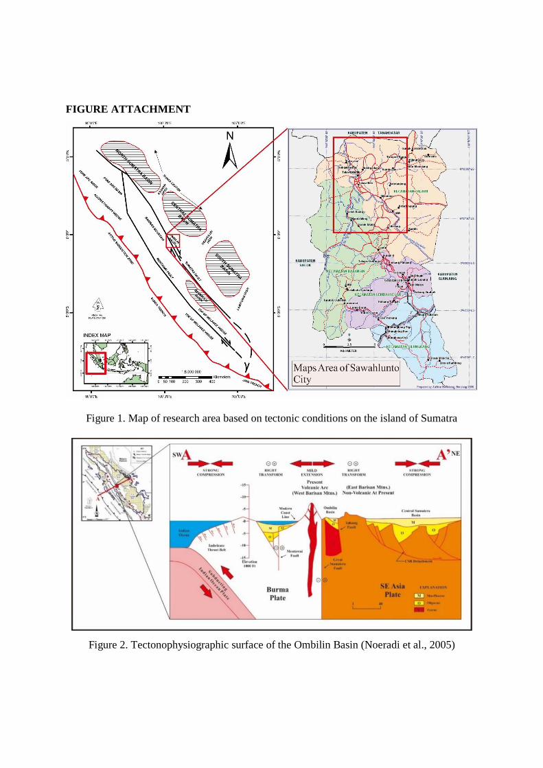
FIGURE ATTACHMENT
Figure 1. Map of research area based on tectonic conditions on the island of Sumatra
Figure 2. Tectonophysiographic surface of the Ombilin Basin (Noeradi et al., 2005)
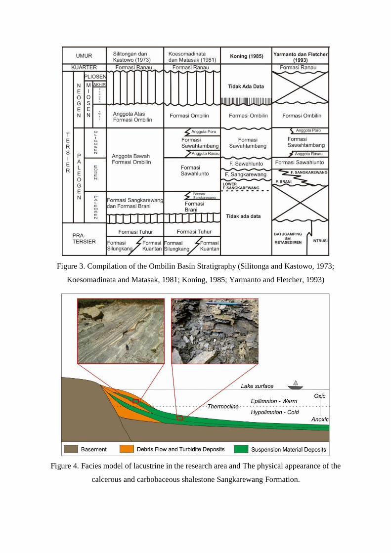
Figure 3. Compilation of the Ombilin Basin Stratigraphy (Silitonga and Kastowo, 1973;
Koesomadinata and Matasak, 1981; Koning, 1985; Yarmanto and Fletcher, 1993)
Figure 4. Facies model of lacustrine in the research area and The physical appearance of the
calcerous and carbobaceous shalestone Sangkarewang Formation.
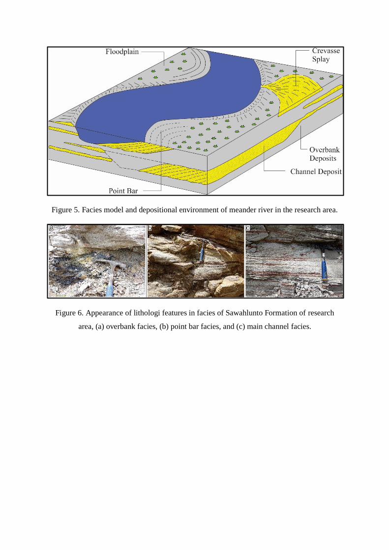
Figure 5. Facies model and depositional environment of meander river in the research area.
Figure 6. Appearance of lithologi features in facies of Sawahlunto Formation of research
area, (a) overbank facies, (b) point bar facies, and (c) main channel facies.
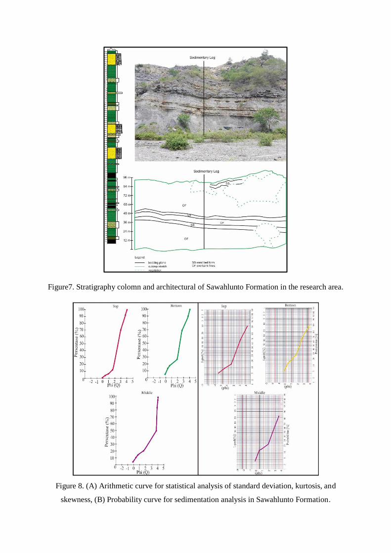
Figure7. Stratigraphy colomn and architectural of Sawahlunto Formation in the research area.
Figure 8. (A) Arithmetic curve for statistical analysis of standard deviation, kurtosis, and
skewness, (B) Probability curve for sedimentation analysis in Sawahlunto Formation.
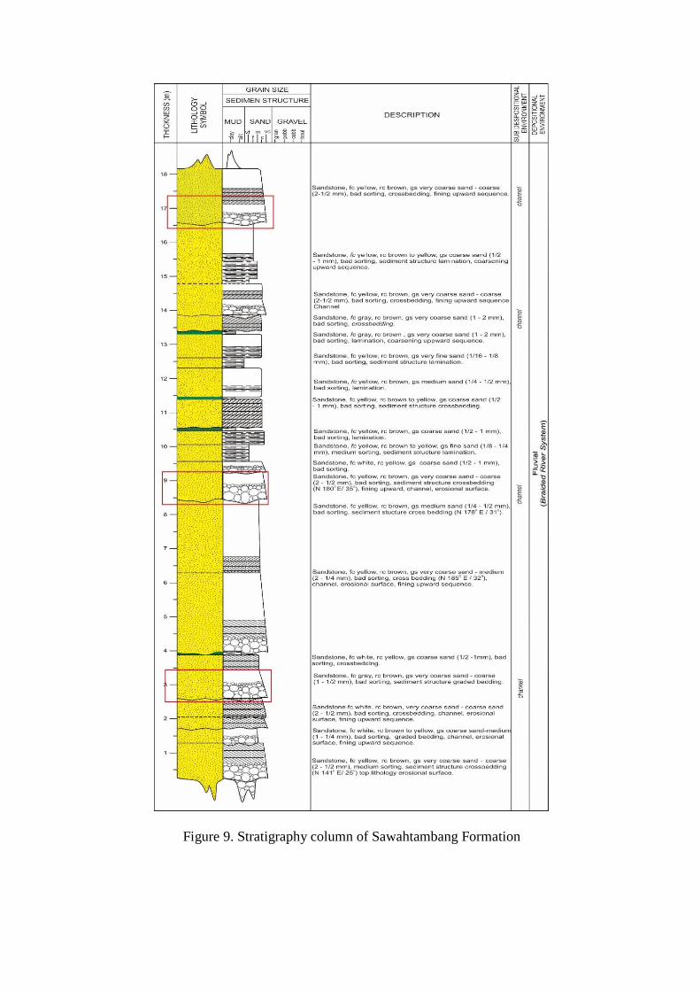
Figure 9. Stratigraphy column of Sawahtambang Formation
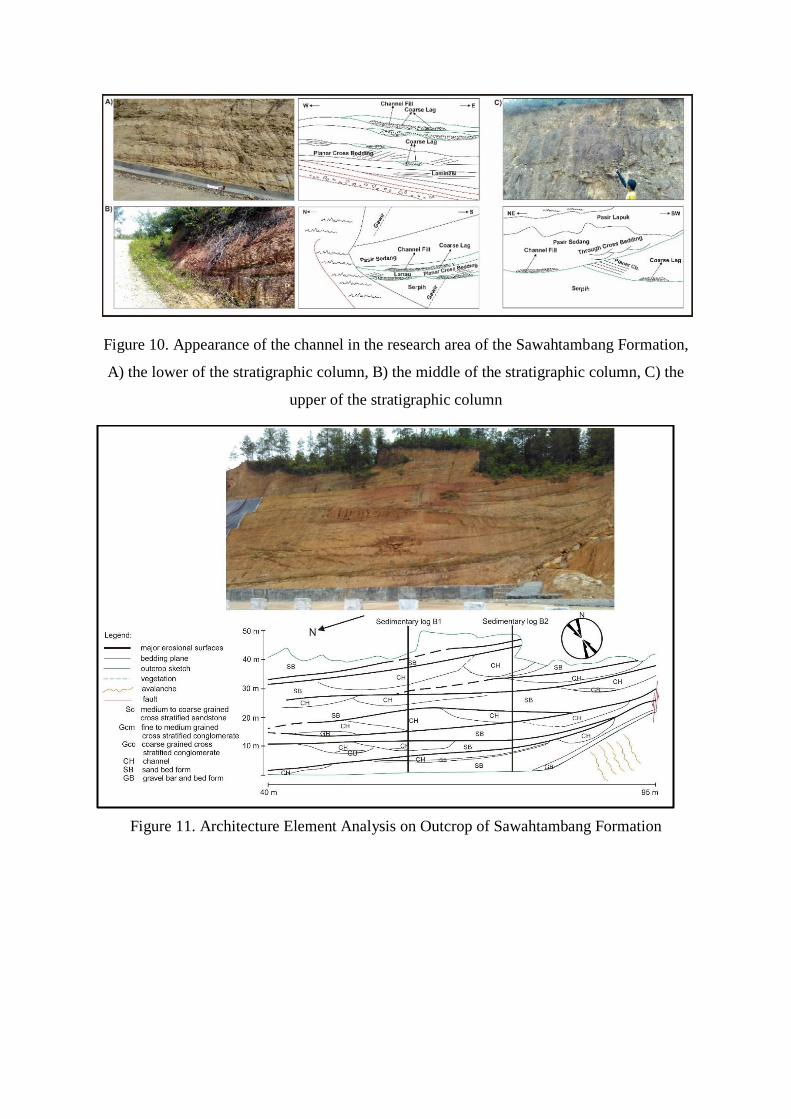
Figure 10. Appearance of the channel in the research area of the Sawahtambang Formation,
A) the lower of the stratigraphic column, B) the middle of the stratigraphic column, C) the
upper of the stratigraphic column
Figure 11. Architecture Element Analysis on Outcrop of Sawahtambang Formation
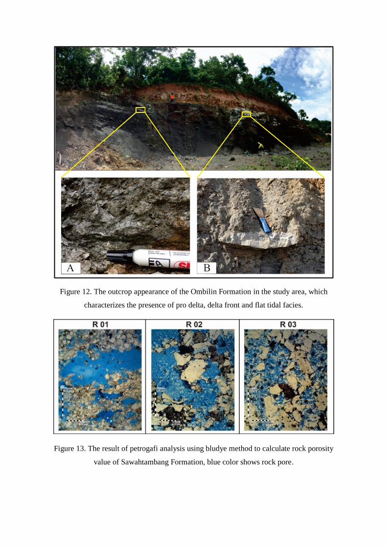
Figure 12. The outcrop appearance of the Ombilin Formation in the study area, which
characterizes the presence of pro delta, delta front and flat tidal facies.
Figure 13. The result of petrogafi analysis using bludye method to calculate rock porosity
value of Sawahtambang Formation, blue color shows rock pore.
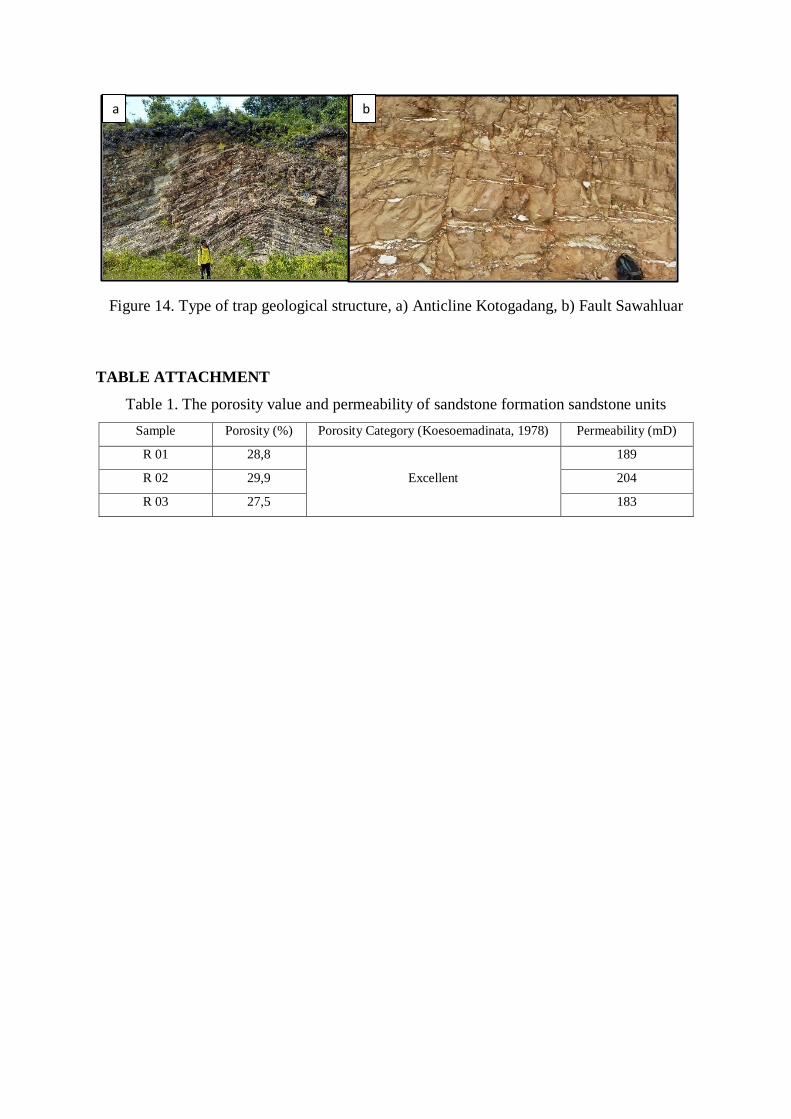
Figure 14. Type of trap geological structure, a) Anticline Kotogadang, b) Fault Sawahluar
TABLE ATTACHMENT
Table 1. The porosity value and permeability of sandstone formation sandstone units
Sample Porosity (%) Porosity Category (Koesoemadinata, 1978) Permeability (mD)
R 01 28,8
Excellent
189
R 02 29,9 204
R 03 27,5 183
a
)
b
)