arcgis online organizations for k12 schools · pdf filearcgis online organizations for k12...
TRANSCRIPT
ArcGIS OnlineOrganizations
for K12 SchoolsFree to any US K12 School (for instructional use)
= Esri's support for ConnectED Initiative
http://www.esri.com/connected
http://esriurl.com/k12gis
20150815

Why GIS for K12 teaching?
• Interactive maps, unlimited topics, global to local
• Usable in science, social studies, math, English/ language arts, technology, engineering, careers, health, service, outdoor/active learning, clubs
• Use for background content + skills
• Rich media – maps, tables, charts, images, video, text
• Representational environment (e.g. thematic map, pop-ups with characteristics, graphs, etc) helps users grasp patterns and relationships but also detail

Why ArcGIS Online for K12 teaching?
• Online = no installs = any connected device (computer, tablet, smartphone) anywhere
• Explore, analyze, modify, save, and share content built by others ("professional") or by oneself
• Ease of use = engagement
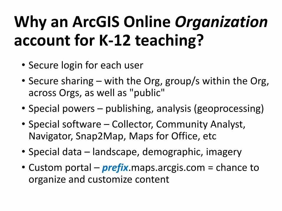
Why an ArcGIS Online Organization account for K-12 teaching?
• Secure login for each user
• Secure sharing – with the Org, group/s within the Org, across Orgs, as well as "public"
• Special powers – publishing, analysis (geoprocessing)
• Special software – Collector, Community Analyst, Navigator, Snap2Map, Maps for Office, etc
• Special data – landscape, demographic, imagery
• Custom portal – prefix.maps.arcgis.com = chance to organize and customize content
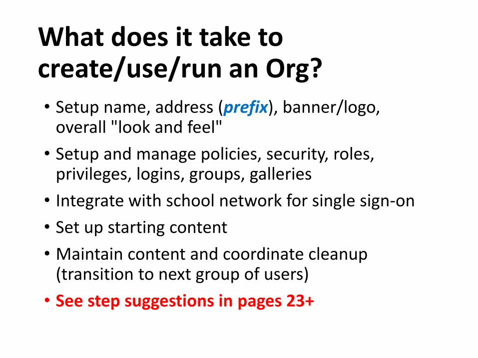
What does it take to create/use/run an Org?• Setup name, address (prefix), banner/logo,
overall "look and feel"
• Setup and manage policies, security, roles, privileges, logins, groups, galleries
• Integrate with school network for single sign-on
• Set up starting content
• Maintain content and coordinate cleanup (transition to next group of users)
• See step suggestions in pages 23+

School Org can be …
• Portal: Link Center/ Launch Pad/ Content Organizer
• Warehouse: Storage zone for individuals' creations
• Login Manager: Zone for creating logins used in accessing various apps
• Different things for different users in the same Org
http://prefix.maps.arcgis.com
… descriptive, not prescriptive …

Custom address
Custom image & name
Custom featured content in carousel
Custom text for links and info
Example Org
Elements can be set to "public" or "members only"
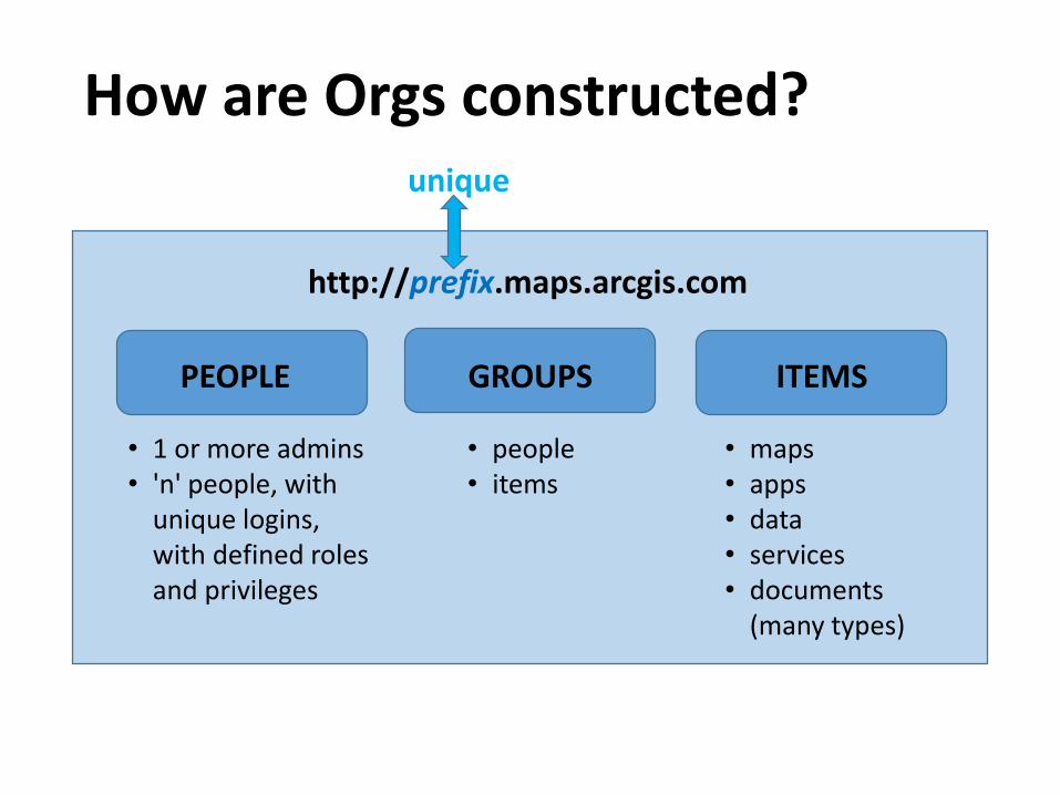
How are Orgs constructed?
PEOPLE GROUPS ITEMS
• 1 or more admins• 'n' people, with
unique logins, with defined roles and privileges
• people• items
• maps• apps• data• services• documents
(many types)
http://prefix.maps.arcgis.com
unique

How are roles/privileges set? (1)Privilege User Publisher Admin Custom
Use maps and apps √ √ √ √
Create content √ √ √ Optional
Share maps and apps √ √ √ Optional
Join and create groups √ √ √ Optional
Edit features √ √ √ Optional
Publish hosted web layers √ √ Optional
Perform analysis √ √ Optional
Manage Open Data sites √ Optional
Invite users to Organization √ Optional
Manage Organization resources √ Optional
View subscription status √ Optional
Configure website √
Create custom roles √
ArcGIS Marketplace provider (req. org. auth.) √

How are roles/privileges set? (2)GENERAL PRIVILEGES
GROUPS CONTENT SHARING
Create, update, delete Create, update, delete Share with groups
Join organizational groups Publish hosted features Share with organization
Join external groups Publish hosted tiles Share with public
Make groups visible to organization
GEOSERVICES FEATURES Make groups visible to public
Geocoding Edit (depending on controls) Make groups available to open data sites
Network analysis Manage open data sites
Spatial analysis
Geoenrichment
Demographics
Elevation
ADMINISTRATIVE PRIVILEGES
MEMBERS GROUPS CONTENT
View all member account info View group owned by member View content owned by member
Update member account info Update group owned by member Update content owned by member
Delete member from the organization Delete group owned by member Delete content owned by member
Invite members to the organization Reassign ownership of groups Reassign ownership of content
Change role of members Add member to groups ARCGIS MARKETPLACE
Manage licenses for members Request purchases, start trials

Example role/privilege setups
… descriptive, not prescriptive …

Teacher & student logins
Teachers Students
http://prefix.maps.arcgis.com => use "prefix" in logins
• prefix.1001
• prefix.1002
• prefix.1003
• prefix.1004
• prefix.1005
• prefix.....
• prefix.MsJLi
• prefix.MsJLee
• prefix.MrDBrown
• prefix.MrTBrown
• prefix.MsAGreen
• prefix.MrAGreen
• prefix.1101
• prefix.1102
• prefix.1103
• prefix.1104
• prefix.1105
• prefix.....
• prefix.1201
• prefix.1202
• prefix.1203
• prefix.1204
• prefix.1205
• prefix.....
Make generic logins, assign to students
Logins are used regularly. Short "prefix" is easier to type, especially on phones. Excellent option = "single sign-on."

Example groups in a school Org
• Science Teachers
• All Students
• Service Club
• Grade 6
• Student Council
• Newspaper
• Spanish 1A, 1B, 1C, 2A, 2B, 3
• AP Human Geography
• Athletics
• Inter-school Project 1,2,3…
Groups are just collections, or organizers.
Each group has its own set of properties.
People and items can be in multiple groups.
Groups can include users from other Orgs, if desired.

2 "mature" school examples …
Large High School
http://prefix.maps.arcgis.com
… descriptive, not prescriptive …
Small Elementary

Large high school Org example
PEOPLE GROUPS ITEMS
http://largehs.maps.arcgis.com
• 1 primary admin• 9 support admins• 20 teacher power users• 100 teacher users• 40 student power users• 1200 students, custom
PrivilegeSets A,B,C,D,E
• 20 "faculty"• 1 "all students"• 4 "grade"• 12 "grade subsets"• 80 "subject/grade"• 25 "club/yearly"• 25 "project/ad hoc"
• Many maps• Many apps• Many data sets• Many services• Many documents
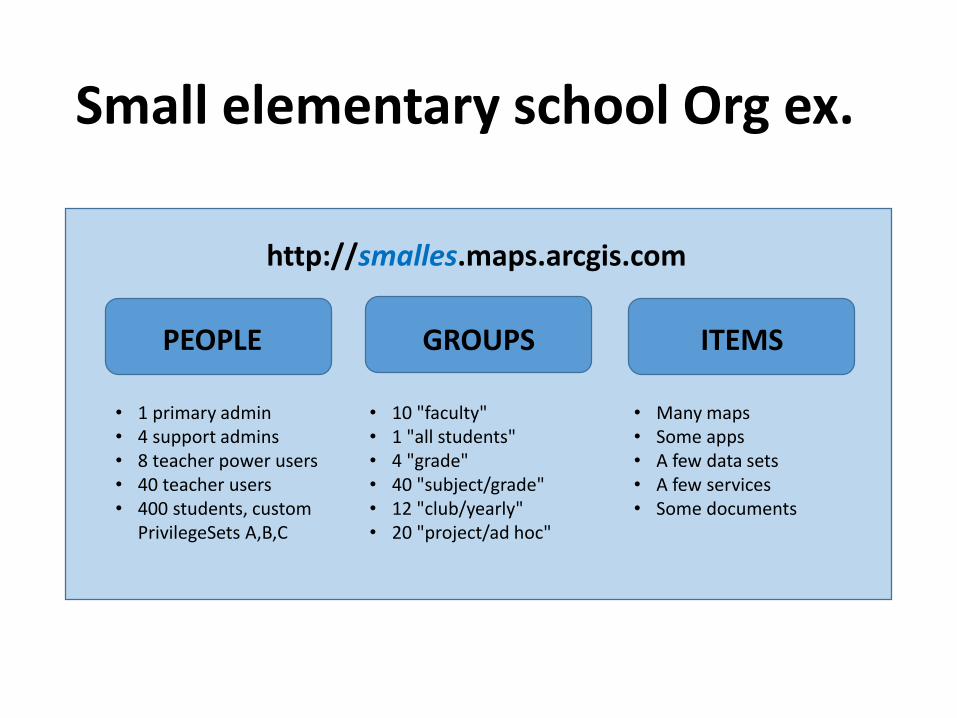
Small elementary school Org ex.
PEOPLE GROUPS ITEMS
http://smalles.maps.arcgis.com
• Many maps• Some apps• A few data sets• A few services• Some documents
• 10 "faculty"• 1 "all students"• 4 "grade"• 40 "subject/grade"• 12 "club/yearly"• 20 "project/ad hoc"
• 1 primary admin• 4 support admins• 8 teacher power users• 40 teacher users• 400 students, custom
PrivilegeSets A,B,C

Example Org growth … #1 of 4
PEOPLE GROUPS ITEMS
http://largehs.maps.arcgis.com
• 1 primary admin• 1 support admin• 0 teacher power users• 5 teacher users• 0 student power users• 100 students, custom
PrivilegeSets A,B,C
• 2 "faculty"• 1 "all students"• 4 "grade" (incl. empty)• 12 "grade subsets"• 10 "subject/grade"• 5 "club/yearly"• 5 "project/ad hoc"
• Some maps• Few apps• Few data sets• Few services• No documents
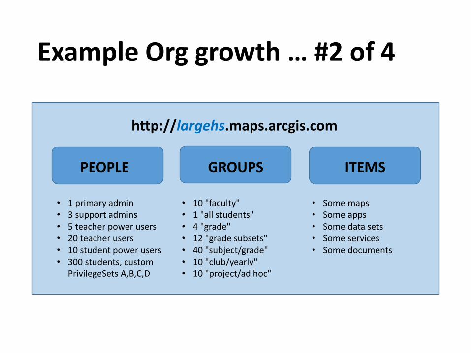
Example Org growth … #2 of 4
PEOPLE GROUPS ITEMS
http://largehs.maps.arcgis.com
• 1 primary admin• 3 support admins• 5 teacher power users• 20 teacher users• 10 student power users• 300 students, custom
PrivilegeSets A,B,C,D
• 10 "faculty"• 1 "all students"• 4 "grade"• 12 "grade subsets"• 40 "subject/grade"• 10 "club/yearly"• 10 "project/ad hoc"
• Some maps• Some apps• Some data sets• Some services• Some documents

Example Org growth … #3 of 4
PEOPLE GROUPS ITEMS
http://largehs.maps.arcgis.com
• 1 primary admin• 6 support admins• 10 teacher power users• 100 teacher users• 20 student power users• 600 students, custom
PrivilegeSets A,B,C,D,E
• 20 "faculty"• 1 "all students"• 4 "grade"• 12 "grade subsets"• 80 "subject/grade"• 25 "club/yearly"• 25 "project/ad hoc"
• Many maps• Many apps• Many data sets• Many services• Many documents

Example Org growth … #4 of 4
PEOPLE GROUPS ITEMS
http://largehs.maps.arcgis.com
• 1 primary admin• 9 support admins• 20 teacher power users• 100 teacher users• 40 student power users• 1200 students, custom
PrivilegeSets A,B,C,D,E
• 20 "faculty"• 1 "all students"• 4 "grade"• 12 "grade subsets"• 80 "subject/grade"• 25 "club/yearly"• 25 "project/ad hoc"
• Many maps• Many apps• Many data sets• Many services• Many documents

ELEMELEMELEMELEMELEMELEMELEM
One possible district setup
HIGH
MIDDLE
ELEM
District + each school has its own http://prefix.maps.arcgis.com
HIGHHIGH
MIDDLEMIDDLEMIDDLEMIDDLEMIDDLE
ELEMELEMELEMELEMELEMELEM
Inter-school groups with any number of members from any number of schools
DISTRICT

A different district setup
The HS MS 1+2 ES 1+2+3+4
Each grade band has its own http://prefix.maps.arcgis.com
Flexible design = lots of ways to construct and collaborate.
Inter-school groups with any number of members from any number of schools
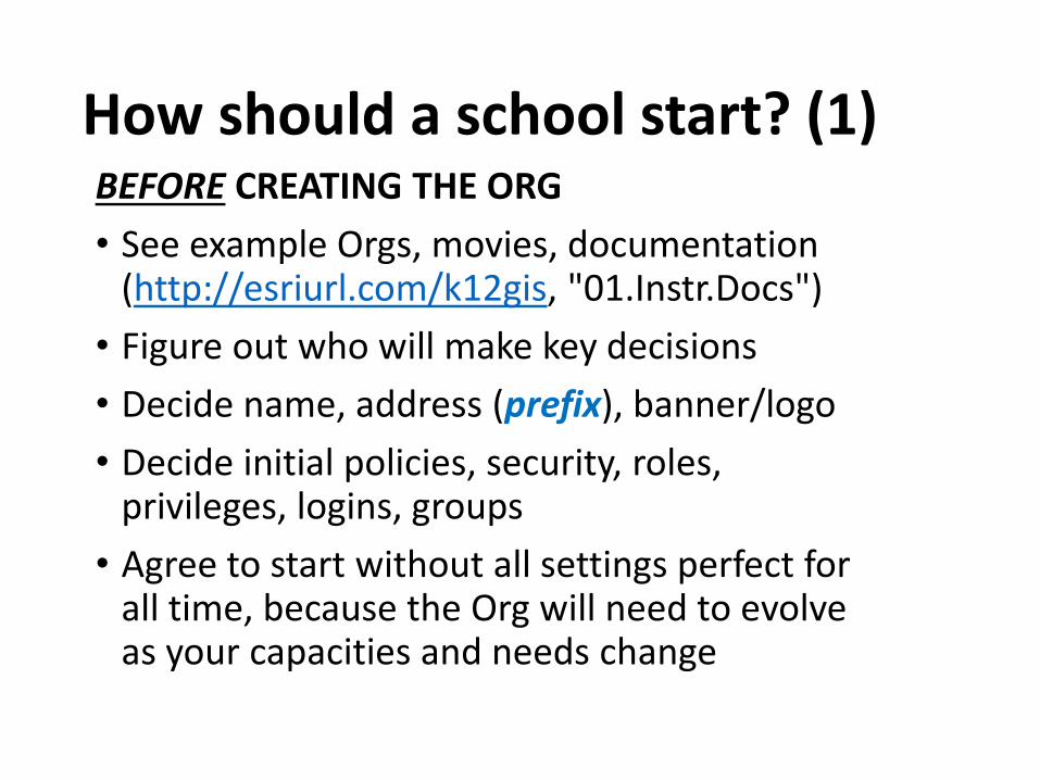
How should a school start? (1)BEFORE CREATING THE ORG
• See example Orgs, movies, documentation (http://esriurl.com/k12gis, "01.Instr.Docs")
• Figure out who will make key decisions
• Decide name, address (prefix), banner/logo
• Decide initial policies, security, roles, privileges, logins, groups
• Agree to start without all settings perfect for all time, because the Org will need to evolve as your capacities and needs change

How should a school start? (2)CREATING THE ORG
• Activate the invitation
• Set up the name and address (prefix)
• Set up a few test logins with different roles
• Test and tweak
• Complete the basic configuration: security, roles, privileges, logins, groups
• Begin using for instruction
• Modify the Org as needed

What choices influence "security"?• Who has which admin privileges?
• Use SSL (http or https)?
• Permit anonymous access (e.g. see "home")?
• Permit users to share beyond Org?
• Permit users to join groups beyond Org?
• Use generic logins (e.g. "prefix.1234")?
• Use generic admin email in creating logins?
• Permit login profiles to be publicly visible?
NOTE: Each of these choices can influence other things as well as security.
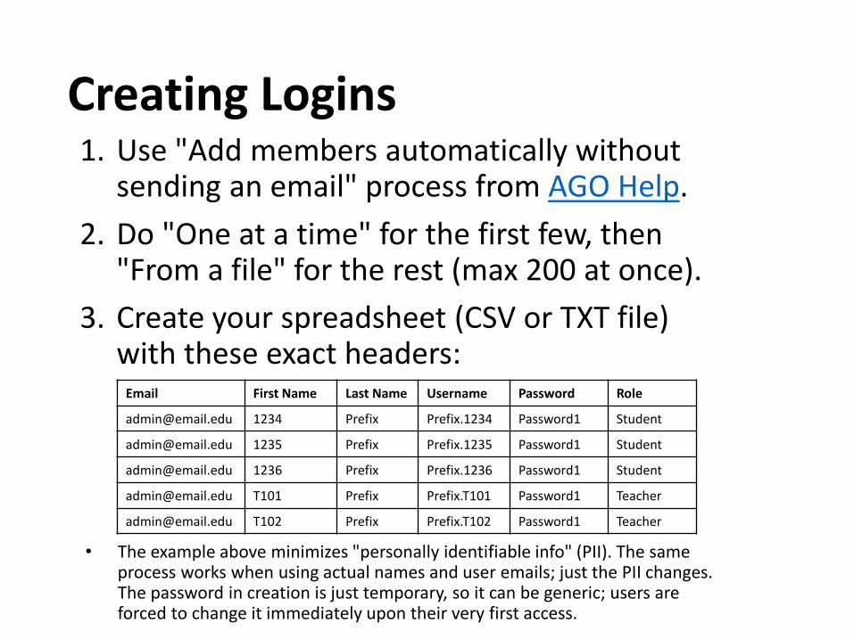
Creating Logins1. Use "Add members automatically without
sending an email" process from AGO Help.
2. Do "One at a time" for the first few, then "From a file" for the rest (max 200 at once).
3. Create your spreadsheet (CSV or TXT file) with these exact headers:
Email First Name Last Name Username Password Role
[email protected] 1234 Prefix Prefix.1234 Password1 Student
[email protected] 1235 Prefix Prefix.1235 Password1 Student
[email protected] 1236 Prefix Prefix.1236 Password1 Student
[email protected] T101 Prefix Prefix.T101 Password1 Teacher
[email protected] T102 Prefix Prefix.T102 Password1 Teacher
• The example above minimizes "personally identifiable info" (PII). The same process works when using actual names and user emails; just the PII changes. The password in creation is just temporary, so it can be generic; users are forced to change it immediately upon their very first access.

Counting Credits and Logins• Orgs get 'n' logins, which represent unique named
users (no sharing permitted). "Commercial" Orgs pay for additional logins; these have real value.
• Orgs get 'n' credits, which get consumed by storage, using premium content, and computation (analysis or service creation). "Commercial" Orgs pay for additional credits; these have real value.
• "Instructional" Orgs get best price for logins and credits. Admins should manage for "informed consumption," and users should practice it, in order to prepare for Org operation in the wider world.
• If in need of logins or credits, contact Esri.
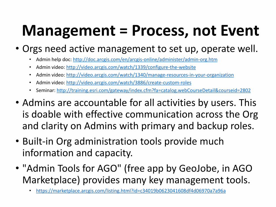
Management = Process, not Event• Orgs need active management to set up, operate well.
• Admin help doc: http://doc.arcgis.com/en/arcgis-online/administer/admin-org.htm
• Admin video: http://video.arcgis.com/watch/1339/configure-the-website
• Admin video: http://video.arcgis.com/watch/1340/manage-resources-in-your-organization
• Admin video: http://video.arcgis.com/watch/3886/create-custom-roles
• Seminar: http://training.esri.com/gateway/index.cfm?fa=catalog.webCourseDetail&courseid=2802
• Admins are accountable for all activities by users. This is doable with effective communication across the Org and clarity on Admins with primary and backup roles.
• Built-in Org administration tools provide much information and capacity.
• "Admin Tools for AGO" (free app by GeoJobe, in AGO Marketplace) provides many key management tools.
• https://marketplace.arcgis.com/listing.html?id=c34019b0623041608df4d06970a7a96a

ArcGIS Online Help DocDetailed, up-to-date guidance on all topics
http://doc.arcgis.com/en/arcgis-online/

Org Options Available
• Standard: Logins and credits vary according to user license – commercial, government, NPO/NGO, education. USK12ed has a special program via Esri/ConnectED (next page).
• Trial: 5 logins, 200 credits, 60 days (limit of 1 trial ever per email address).
• Developer: Build skills, on up to build a business. Free plan has 1 login, 50 credits (no rollover) per month = good idea for every educator: maintain capacity despite changes in employment, connect to your other Org personas via private group.

Esri's offer as part of White House's ConnectED Initiative
• ArcGIS Online Org to any U.S. K12 school (public, nonpublic, or home school), for instruction, for free
• Guidance and instructional materials
• Links to mentors (interested GIS users)
• Professional development opportunities for educators
http://www.esri.com/connected
http://esriurl.com/k12gis

ArcGIS OnlineOrganizations
for K12 SchoolsFree to any US K12 School (for instructional use)
= Esri's support for ConnectED Initiative
http://www.esri.com/connected
http://esriurl.com/k12gis
20150815