arcgis 10.1 projection engine tables: geographic and ... · arcgis 10.1 projection engine tables:...
TRANSCRIPT

Copyright © 2012 Esri 1
ArcGIS 10.1 projection engine tables: geographic and vertical coordinate systems, datums and vertical datums, spheroids, prime meridians, and angular units of measure
Note: Some numerical values have been rounded for display. The extent values for an area of use are in decimal
degrees based on WGS 1984.
Table 1: Geographic coordinate systems: well-known IDs and areas of use .......................................................................... 1
Table 2: Geographic coordinate systems: non-Greenwich or non-degree definitions ......................................................... 19
Table 3: Geodetic datums: well-known IDs and spheroids ................................................................................................... 19
Table 4: Angular units: well-known IDs and conversion values ............................................................................................ 31
Table 5: Prime meridians: well-known IDs and longitude values ......................................................................................... 31
Table 6: Spheroids: well-known IDs and defining parameters ............................................................................................. 31
Table 7: Vertical coordinate systems: well-known IDs and areas of use .............................................................................. 36
Table 8: Vertical coordinate systems: gravity-related or ellipsoidal-based and directions .................................................. 39
Table 9: Vertical datums: well-known IDs ............................................................................................................................. 41
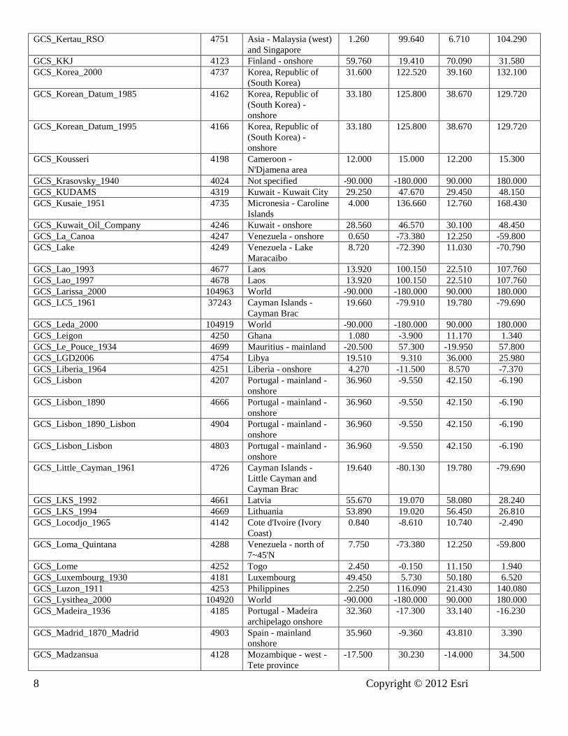
Table 1: Geographic coordinate systems: well-known IDs and areas of use
GCS Name WKID Area of Use Minimum
Latitude
Minimum
Longitude
Maximum
Latitude
Maximum
Longitude
GCS_Abidjan_1987 4143 Cote d'Ivoire (Ivory
Coast)
0.840 -8.610 10.740 -2.490
GCS_Accra 4168 Ghana 1.080 -3.900 11.170 1.340
GCS_Adindan 4201 Africa - Eritrea,
Ethiopia, South Sudan
and Sudan
3.410 21.830 22.230 47.990
GCS_Adrastea_2000 104909 World -90.000 -180.000 90.000 180.000
GCS_Afgooye 4205 Somalia -2.390 41.010 13.400 54.980
GCS_Agadez 4206 Niger 11.700 0.170 23.540 16.010
GCS_Ain_el_Abd_1970 4204 Asia - Middle East -
Bahrain, Kuwait and
Saudi Arabia
16.380 34.570 32.150 55.670
GCS_Airy_1830 4001 Not specified -90.000 -180.000 90.000 180.000
GCS_Airy_Modified 4002 Not specified -90.000 -180.000 90.000 180.000
GCS_Alaskan_Islands 37260 USA - Alaska 51.300 172.430 71.400 -129.990
GCS_Albanian_1987 4191 Albania - onshore 39.640 19.220 42.660 21.050
GCS_Amalthea_2000 104910 World -90.000 -180.000 90.000 180.000
GCS_American_Samoa_1962 4169 American Samoa - 2
main island groups
-14.430 -170.870 -14.120 -169.390
GCS_Amersfoort 4289 Netherlands - onshore 50.750 3.210 53.710 7.210
GCS_Ammassalik_1958 4196 Greenland -
Ammassalik area
65.520 -38.860 65.900 -36.820
GCS_Ananke_2000 104911 World -90.000 -180.000 90.000 180.000
GCS_Anguilla_1957 4600 Anguilla - onshore 18.120 -63.220 18.320 -62.920
GCS_Anna_1_1965 4708 Cocos (Keeling)
Islands - onshore
-15.540 93.540 -5.890 102.430
GCS_Antigua_1943 4601 Antigua - onshore 16.940 -61.940 17.210 -61.620

2 Copyright © 2012 Esri
GCS_Aratu 4208 Brazil - Aratu -35.710 -53.370 4.250 -26.010
GCS_Arc_1950 4209 Africa - Botswana,
Malawi, Zambia,
Zimbabwe
-26.880 20.000 -8.190 35.920
GCS_Arc_1960 4210 Africa - Kenya,
Tanzania and Uganda
-11.740 29.340 4.620 41.910
GCS_Ariel_2000 104945 World -90.000 -180.000 90.000 180.000
GCS_Ascension_Island_1958 4712 St Helena - Ascension
Island
-7.990 -14.420 -7.880 -14.290
GCS_Astro_1952 4711 Japan - Minamitori-
shima (Marcus Island)
24.260 153.950 24.320 154.010
GCS_ATF_Paris 4901 France - mainland
onshore
42.330 -4.870 51.140 8.230
GCS_Atlas_2000 104926 World -90.000 -180.000 90.000 180.000
GCS_ATS_1977 4122 Canada - Maritime
Provinces
43.420 -69.050 48.070 -59.740
GCS_Australian 4003 Not specified -90.000 -180.000 90.000 180.000
GCS_Australian_1966 4202 Australasia - Australia
and PNG - AGD66
-45.000 108.000 -1.330 156.000
GCS_Australian_1984 4203 Australia - AGD84 -39.000 108.000 -10.000 155.000
GCS_Australian_Antarctic_1998 4176 Antarctica - Australian
sector
-90.000 45.000 -60.000 160.000
GCS_Ayabelle 4713 Djibouti 10.940 41.780 12.830 44.050
GCS_Azores_Central_1948 4183 Portugal - Azores C -
onshore
38.320 -28.900 39.140 -26.970
GCS_Azores_Central_1995 4665 Portugal - Azores C -
onshore
38.320 -28.900 39.140 -26.970
GCS_Azores_Occidental_1939 4182 Portugal - Azores W -
onshore
39.300 -31.340 39.760 -31.020
GCS_Azores_Oriental_1940 4184 Portugal - Azores E -
onshore
36.880 -25.910 37.960 -24.960
GCS_Azores_Oriental_1995 4664 Portugal - Azores E -
onshore
36.880 -25.910 37.960 -24.960
GCS_Bab_South 104112 Palau 0.000 130.660 10.910 146.420
GCS_Barbados_1938 4212 Barbados - onshore 13.000 -59.710 13.390 -59.380
GCS_Batavia 4211 Indonesia - Java and
Java Sea
-8.780 105.110 -4.000 115.570
GCS_Batavia_Jakarta 4813 Indonesia - Java -8.780 105.110 -5.730 115.570
GCS_Beacon_E_1945 4709 Japan - Iwo Jima 24.740 141.280 24.820 141.360
GCS_Beduaram 4213 Niger - southeast 12.600 8.000 16.500 15.500
GCS_Beijing_1954 4214 China - onshore 18.040 73.660 53.590 134.850
GCS_Belge_1950 4215 Belgium - onshore 49.510 2.510 51.500 6.400
GCS_Belge_1950_Brussels 4809 Belgium - onshore 49.510 2.510 51.500 6.400
GCS_Belge_1972 4313 Belgium - onshore 49.510 2.510 51.500 6.400
GCS_Belinda_2000 104946 World -90.000 -180.000 90.000 180.000
GCS_Bellevue_IGN 4714 Vanuatu - southern
islands
-19.700 168.100 -17.400 169.640
GCS_Bermuda_1957 4216 Bermuda - onshore 32.210 -64.880 32.430 -64.620
GCS_Bermuda_2000 4762 Bermuda 28.910 -68.830 35.720 -60.710
GCS_Bern_1898_Bern 4801 Europe - Liechtenstein
and Switzerland
45.830 5.970 47.810 10.490
GCS_Bern_1938 4306 Europe - Liechtenstein
and Switzerland
45.830 5.970 47.810 10.490
GCS_Bessel_1841 4004 Not specified -90.000 -180.000 90.000 180.000
GCS_Bessel_Modified 4005 Not specified -90.000 -180.000 90.000 180.000
GCS_Bessel_Namibia 4006 Not specified -90.000 -180.000 90.000 180.000
GCS_Bianca_2000 104947 World -90.000 -180.000 90.000 180.000
GCS_Bissau 4165 Guinea-Bissau - 10.890 -16.730 12.690 -13.650

Copyright © 2012 Esri 3
onshore
GCS_Bogota 4218 Colombia - mainland
and offshore
Caribbean
-4.240 -79.100 13.670 -66.870
GCS_Bogota_Bogota 4802 Colombia - mainland -4.240 -79.100 12.510 -66.870
GCS_Bukit_Rimpah 4219 Indonesia - Banga &
Belitung Islands
-3.250 105.120 -1.490 108.290
GCS_Cadastre_1997 4475 Mayotte - onshore -13.000 44.970 -12.600 45.320
GCS_Callisto_2000 104912 World -90.000 -180.000 90.000 180.000
GCS_Calypso_2000 104927 World -90.000 -180.000 90.000 180.000
GCS_Camacupa 4220 Angola - Angola
proper
-18.050 12.110 -5.750 24.100
GCS_Camp_Area 4715 Antarctica - Camp
McMurdo area
-78.000 165.500 -77.000 167.000
GCS_Campo_Inchauspe 4221 Argentina -58.400 -73.580 -21.780 -52.630
GCS_Canton_1966 4716 Kiribati - Phoenix
Islands
-4.640 -174.200 -2.720 -171.300
GCS_Cape 4222 Africa - Botswana,
Lesotho, South Africa
and Swaziland
-46.970 16.480 -17.780 37.890
GCS_Cape_Canaveral 4717 North America -
Bahamas and USA -
Florida - onshore
20.870 -82.330 30.830 -72.690
GCS_Carme_2000 104913 World -90.000 -180.000 90.000 180.000
GCS_Carthage 4223 Tunisia 30.250 7.500 38.430 13.740
GCS_Carthage_Grad 37225 Tunisia 30.250 7.500 38.430 13.740
GCS_Carthage_Paris 4816 Tunisia - onshore 30.250 7.500 37.350 11.630
GCS_CGRS_1993 104141 Cyprus - onshore 34.590 32.210 35.740 34.650
GCS_CH1903 4149 Europe - Liechtenstein
and Switzerland
45.830 5.970 47.810 10.490
GCS_CH1903+ 4150 Europe - Liechtenstein
and Switzerland
45.830 5.970 47.810 10.490
GCS_Charon_2000 104970 World -90.000 -180.000 90.000 180.000
GCS_Chatham_Island_1971 4672 New Zealand -
Chatham Islands
group
-45.000 -178.000 -43.000 -175.000
GCS_Chatham_Islands_1979 4673 New Zealand -
Chatham Islands
group
-45.000 -178.000 -43.000 -175.000
GCS_China_Geodetic_Coordinate_System
_2000
4490 China 7.160 73.660 53.590 134.850
GCS_Chos_Malal_1914 4160 Argentina - Neuquen
province
-41.090 -71.950 -36.150 -68.010
GCS_Chua 4224 South America -
Brazil - south of 18~S
and west of 54~W +
DF; N Paraguay
-31.910 -62.560 -15.380 -47.100
GCS_Clarke_1858 4007 Not specified -90.000 -180.000 90.000 180.000
GCS_Clarke_1866 4008 Not specified -90.000 -180.000 90.000 180.000
GCS_Clarke_1866_Michigan 4009 Not specified -90.000 -180.000 90.000 180.000
GCS_Clarke_1880 4034 Not specified -90.000 -180.000 90.000 180.000
GCS_Clarke_1880_Arc 4013 Not specified -90.000 -180.000 90.000 180.000
GCS_Clarke_1880_Benoit 4010 Not specified -90.000 -180.000 90.000 180.000
GCS_Clarke_1880_IGN 4011 Not specified -90.000 -180.000 90.000 180.000
GCS_Clarke_1880_RGS 4012 Not specified -90.000 -180.000 90.000 180.000
GCS_Clarke_1880_SGA 4014 Not specified -90.000 -180.000 90.000 180.000
GCS_Combani_1950 4632 Mayotte - onshore -13.000 44.970 -12.600 45.320
GCS_Conakry_1905 4315 Guinea - onshore 7.160 -15.120 12.690 -7.650

4 Copyright © 2012 Esri
GCS_Cordelia_2000 104948 World -90.000 -180.000 90.000 180.000
GCS_Corrego_Alegre 4225 Brazil - Corrego
Alegre 1970-1972
-33.780 -58.160 -2.680 -34.740
GCS_Corrego_Alegre_1961 5524 Brazil - Corrego
Alegre 1961
-27.500 -58.160 -15.000 -38.820
GCS_Cote_d_Ivoire 4226 Cote d'Ivoire (Ivory
Coast)
0.840 -8.610 10.740 -2.490
GCS_CR05 5365 Costa Rica 2.150 -90.440 11.770 -81.430
GCS_Cressida_2000 104949 World -90.000 -180.000 90.000 180.000
GCS_CSG_1967 4623 French Guiana -
coastal area
3.430 -54.450 5.810 -51.620
GCS_D48 104131 Slovenia 45.430 13.380 46.880 16.610
GCS_Dabola_1981 4155 Guinea - onshore 7.160 -15.120 12.690 -7.650
GCS_Datum_73 4274 Portugal - mainland -
onshore
36.960 -9.550 42.150 -6.190
GCS_Datum_Lisboa_Bessel 104105 Portugal 29.250 -35.580 43.070 -6.190
GCS_Datum_Lisboa_Hayford 104106 Portugal 29.250 -35.580 43.070 -6.190
GCS_Dealul_Piscului_1933 4316 Romania - onshore 43.620 20.260 48.260 29.730
GCS_Dealul_Piscului_1970 4317 Romania 43.450 20.260 48.260 31.410
GCS_Deception_Island 4736 Antarctica - Antarctic
Peninsula and
Deception Island
-64.100 -61.000 -62.860 -60.180
GCS_Deimos_2000 104906 World -90.000 -180.000 90.000 180.000
GCS_Deir_ez_Zor 4227 Asia - Middle East -
Lebanon and Syria
onshore
32.310 35.100 37.290 42.380
GCS_Desdemona_2000 104950 World -90.000 -180.000 90.000 180.000
GCS_Despina_2000 104961 World -90.000 -180.000 90.000 180.000
GCS_Deutsches_Hauptdreiecksnetz 4314 Germany - West
Germany all states
47.270 5.870 55.090 13.830
GCS_DGN_1995 4755 Indonesia -13.010 91.660 7.920 141.100
GCS_Dione_2000 104928 World -90.000 -180.000 90.000 180.000
GCS_Dominica_1945 4602 Dominica - onshore 15.150 -61.540 15.680 -61.200
GCS_DOS_1968 37218 Solomon Islands -
New Georgia - Ghizo
(Gizo)
-8.150 156.700 -8.000 156.900
GCS_DOS_71_4 4710 St Helena - St Helena
Island
-16.030 -5.810 -15.880 -5.630
GCS_Douala 4228 Cameroon 1.660 8.380 13.090 16.220
GCS_Douala_1948 4192 Cameroon - coastal
area
1.500 8.400 5.000 12.000
GCS_DRUKREF_03 5264 Bhutan 26.700 88.740 28.250 92.130
GCS_Easter_Island_1967 4719 Chile - Easter Island
onshore
-27.250 -109.500 -27.020 -109.160
GCS_Egypt_1907 4229 Egypt 21.990 24.710 33.750 36.900
GCS_Egypt_1930 4199 Egypt - onshore 21.990 24.710 31.650 36.900
GCS_Egypt_Gulf_of_Suez_S-650_TL 4706 Egypt - Gulf of Suez 27.300 32.300 29.960 34.250
GCS_Elara_2000 104914 World -90.000 -180.000 90.000 180.000
GCS_Enceladus_2000 104929 World -90.000 -180.000 90.000 180.000
GCS_Epimetheus_2000 104930 World -90.000 -180.000 90.000 180.000
GCS_Estonia_1937 104101 Estonia 57.520 20.370 59.990 28.190
GCS_Estonia_1992 4133 Estonia 57.520 20.370 59.990 28.190
GCS_Estonia_1997 4180 Estonia 57.520 20.370 59.990 28.190
GCS_ETRF_1989 104258 Europe - ETRS89 32.880 -16.100 84.160 39.640
GCS_ETRS_1989 4258 Europe - ETRS89 32.880 -16.100 84.160 39.640
GCS_EUREF_FIN 104129 Finland 58.840 19.080 70.090 31.580
GCS_Europa_2000 104915 World -90.000 -180.000 90.000 180.000
GCS_European_1950 4230 Europe - ED50 by 25.710 -16.100 84.160 48.610

Copyright © 2012 Esri 5
country
GCS_European_1950_ED77 4154 Iran 23.350 44.060 39.800 63.370
GCS_European_1979 4668 Europe - west 34.880 -10.560 71.200 31.580
GCS_European_1987 4231 Europe - west 34.880 -10.560 71.200 31.580
GCS_European_Libyan_Datum_1979 4159 Libya 19.510 9.310 36.000 25.980
GCS_Everest_1830 4042 Not specified -90.000 -180.000 90.000 180.000
GCS_Everest_Adj_1937 4015 Not specified -90.000 -180.000 90.000 180.000
GCS_Everest_Bangladesh 37202 Bangladesh 15.090 88.100 26.650 92.720
GCS_Everest_def_1962 4044 Not specified -90.000 -180.000 90.000 180.000
GCS_Everest_def_1967 4016 Not specified -90.000 -180.000 90.000 180.000
GCS_Everest_def_1975 4045 Not specified -90.000 -180.000 90.000 180.000
GCS_Everest_India_Nepal 37203 India 3.120 66.160 35.550 97.450
GCS_Everest_Modified 4018 Not specified -90.000 -180.000 90.000 180.000
GCS_Everest_Modified_1969 37006 World -90.000 -180.000 90.000 180.000
GCS_Fahud 4232 Oman - onshore 16.600 51.900 26.400 59.890
GCS_Fatu_Iva_1972 4688 French Polynesia -
Marquises Islands -
Fatu Iva
-10.550 -138.700 -10.330 -138.550
GCS_FD_1954 4741 Faroe Islands -
onshore
61.340 -7.480 62.410 -6.340
GCS_FD_1958 4132 Iran - FD58 27.250 47.000 33.000 52.700
GCS_Fiji_1956 4721 Fiji - main islands -18.500 177.000 -16.000 -179.500
GCS_Fiji_1986 4720 Fiji -25.100 172.870 -9.790 -176.160
GCS_Fischer_1960 37002 World -90.000 -180.000 90.000 180.000
GCS_Fischer_1968 37003 World -90.000 -180.000 90.000 180.000
GCS_Fischer_Modified 37004 World -90.000 -180.000 90.000 180.000
GCS_fk89 4753 Faroe Islands -
onshore
61.340 -7.480 62.410 -6.340
GCS_Fort_Desaix 4625 Martinique - onshore 14.350 -61.280 14.930 -60.770
GCS_Fort_Marigot 4621 Guadeloupe - St
Martin and St
Barthelemy - onshore
17.830 -63.200 18.170 -62.730
GCS_Fort_Thomas_1955 37240 St Kitts and Nevis 16.350 -63.630 17.670 -62.200
GCS_Galatea_2000 104962 World -90.000 -180.000 90.000 180.000
GCS_Gan_1970 4684 Maldives - onshore 3.900 73.330 4.500 73.700
GCS_Ganymede_2000 104916 World -90.000 -180.000 90.000 180.000
GCS_Garoua 4234 Cameroon 1.660 8.380 13.090 16.220
GCS_GDA_1994 4283 Australia -60.040 110.770 -8.860 174.100
GCS_GDBD2009 5246 Brunei 4.000 112.500 6.370 115.360
GCS_GDM_2000 4742 Malaysia 0.850 98.120 10.070 119.680
GCS_GEM_10C 4031 Not specified -90.000 -180.000 90.000 180.000
GCS_GGRS_1987 4121 Greece - onshore 34.880 19.580 41.750 28.300
GCS_Graciosa_Base_SW_1948 37241 Portugal - Azores C -
onshore
38.320 -28.900 39.140 -26.970
GCS_Grand_Cayman_1959 4723 Cayman Islands -
Grand Cayman
19.220 -81.450 19.400 -81.040
GCS_Grand_Comoros 4646 Comoros - Njazidja
(Grande Comore)
-11.900 43.200 -11.400 43.500
GCS_Greek 4120 Greece - onshore 34.880 19.580 41.750 28.300
GCS_Greek_Athens 4815 Greece - onshore 34.880 19.580 41.750 28.300
GCS_Greenland_1996 4747 Greenland 56.380 -75.000 87.020 8.120
GCS_Grenada_1953 4603 Grenada and southern
Grenadines - onshore
11.950 -61.830 12.560 -61.350
GCS_GRS_1967 4036 Not specified -90.000 -180.000 90.000 180.000
GCS_GRS_1980 4019 Not specified -90.000 -180.000 90.000 180.000
GCS_Guam_1963 4675 Guam - onshore 13.190 144.580 13.700 145.000
GCS_Gulshan_303 4682 Bangladesh 15.090 88.100 26.650 92.720
GCS_Gunung_Segara 4613 Indonesia - -5.720 113.690 4.400 119.620

6 Copyright © 2012 Esri
Kalimantan E
GCS_Gunung_Segara_Jakarta 4820 Indonesia -
Kalimantan E
-5.720 113.690 4.400 119.620
GCS_GUX_1 37221 Solomon Islands -
Guadalcanal Island
-9.960 159.560 -9.240 160.910
GCS_Guyane_Francaise 4235 French Guiana 2.110 -54.600 8.880 -49.460
GCS_Hanoi_1972 4147 Vietnam - onshore 8.450 103.800 23.390 109.600
GCS_Hartebeesthoek_1994 4148 South Africa -50.340 14.030 -22.140 41.160
GCS_HD1909 3819 Hungary 45.750 16.110 48.580 22.890
GCS_Helene_2000 104931 World -90.000 -180.000 90.000 180.000
GCS_Helle_1954 4660 Jan Mayen - onshore 70.750 -9.170 71.230 -7.880
GCS_Helmert_1906 4020 Not specified -90.000 -180.000 90.000 180.000
GCS_Herat_North 4255 Afghanistan 29.410 60.540 38.500 74.960
GCS_Hermannskogel 104102 Europe - Austria and
FR Yugoslavia
40.860 9.530 51.050 23.030
GCS_Himalia_2000 104917 World -90.000 -180.000 90.000 180.000
GCS_Hito_XVIII_1963 4254 South America -
Tierra del Fuego
-55.950 -74.820 -52.400 -65.060
GCS_Hjorsey_1955 4658 Iceland - onshore 63.350 -24.660 66.580 -13.380
GCS_Hong_Kong_1963 4738 China - Hong Kong 22.160 113.890 22.620 114.570
GCS_Hong_Kong_1963_67 4739 China - Hong Kong 22.160 113.890 22.620 114.570
GCS_Hong_Kong_1980 4611 China - Hong Kong 22.160 113.890 22.620 114.570
GCS_Hough_1960 37005 World -90.000 -180.000 90.000 180.000
GCS_HTRS96 4761 Croatia 41.620 13.010 46.540 19.430
GCS_Hughes_1980 4054 Not specified -90.000 -180.000 90.000 180.000
GCS_Hungarian_1972 4237 Hungary 45.750 16.110 48.580 22.890
GCS_Hu_Tzu_Shan 4236 Taiwan - onshore 21.800 119.400 25.400 122.050
GCS_Hyperion_2000 104932 World -90.000 -180.000 90.000 180.000
GCS_Iapetus_2000 104933 World -90.000 -180.000 90.000 180.000
GCS_IGC_1962_6th_Parallel_South 4697 Congo DR (Zaire) -
6th parallel south
-7.250 12.210 -5.000 30.600
GCS_IGCB_1955 4701 Congo DR (Zaire) -
Bas Congo
-6.100 12.210 -3.950 16.500
GCS_IGM_1995 4670 Italy - including San
Marino and Vatican
34.770 5.940 47.090 18.990
GCS_IGN53_Mare 4641 New Caledonia - Mare -21.700 167.750 -21.300 168.150
GCS_IGN56_Lifou 4633 New Caledonia - Lifou -21.200 167.000 -20.700 167.500
GCS_IGN63_Hiva_Oa 4689 French Polynesia -
Marquises Islands -
Hiva Oa and Tahuata
-10.050 -139.180 -9.670 -138.800
GCS_IGN72_Grande_Terre 4662 New Caledonia -
Grande Terre
-22.500 163.900 -20.000 167.100
GCS_IGN72_Nuku_Hiva 4630 French Polynesia -
Marquises Islands -
Nuku Hiva, Ua Huka
and Ua Pou
-9.500 -140.250 -8.750 -139.450
GCS_IGN_Astro_1960 4700 Mauritania 14.730 -20.410 27.310 -4.810
GCS_IGRS 3889 Iraq 29.060 38.820 37.410 49.400
GCS_IKBD_1992 4667 Asia - Middle East -
Iraq-Kuwait boundary
29.050 46.500 30.100 48.000
GCS_Indian_1954 4239 Asia - Myanmar and
Thailand onshore
5.630 92.200 28.550 105.640
GCS_Indian_1960 4131 Asia - Cambodia and
Vietnam - onshore
8.560 102.140 23.320 109.460
GCS_Indian_1975 4240 Thailand - onshore and
offshore Gulf of
Thailand
5.630 98.000 20.470 105.700
GCS_Indonesian 4021 Not specified -90.000 -180.000 90.000 180.000

Copyright © 2012 Esri 7
GCS_Indonesian_1974 4238 Indonesia -13.010 91.660 7.920 141.100
GCS_International_1924 4022 Not specified -90.000 -180.000 90.000 180.000
GCS_Io_2000 104918 World -90.000 -180.000 90.000 180.000
GCS_IRENET95 4173 Europe - Ireland
(Republic and Ulster) -
on- and offshore
51.330 -10.600 55.400 -5.330
GCS_ISN_1993 4659 Iceland 59.960 -30.860 69.580 -5.560
GCS_ISN_2004 5324 Iceland 59.960 -30.860 69.580 -5.560
GCS_Israel 4141 Asia - Middle East -
Israel and Palestine
Territory onshore
29.490 34.220 33.270 35.680
GCS_ISTS_061_1968 4722 South Georgia -55.220 -38.460 -53.800 -34.630
GCS_ISTS_073_1969 4724 British Indian Ocean
Territory - Diego
Garcia
-7.490 72.340 -7.210 72.500
GCS_ITRF_1988 104115 World -90.000 -180.000 90.000 180.000
GCS_ITRF_1989 104116 World -90.000 -180.000 90.000 180.000
GCS_ITRF_1990 104117 World -90.000 -180.000 90.000 180.000
GCS_ITRF_1991 104118 World -90.000 -180.000 90.000 180.000
GCS_ITRF_1992 104119 World -90.000 -180.000 90.000 180.000
GCS_ITRF_1993 104120 World -90.000 -180.000 90.000 180.000
GCS_ITRF_1994 104121 World -90.000 -180.000 90.000 180.000
GCS_ITRF_1996 104122 World -90.000 -180.000 90.000 180.000
GCS_ITRF_1997 104123 World -90.000 -180.000 90.000 180.000
GCS_ITRF_2000 104124 World -90.000 -180.000 90.000 180.000
GCS_ITRF_2005 104896 World -90.000 -180.000 90.000 180.000
GCS_ITRF_2008 104257 World (by country) -90.000 -180.000 90.000 180.000
GCS_JAD_2001 4758 Jamaica 14.080 -80.590 19.360 -74.510
GCS_Jamaica_1875 4241 Jamaica - onshore 17.650 -78.430 18.570 -76.170
GCS_Jamaica_1969 4242 Jamaica - onshore 17.650 -78.430 18.570 -76.170
GCS_Janus_2000 104934 World -90.000 -180.000 90.000 180.000
GCS_JGD_2000 4612 Japan 19.010 122.490 45.920 160.090
GCS_JGD_2000_
touhokutaiheiyouoki2011
104020 Japan 19.010 122.490 45.920 160.090
GCS_Johnston_Island_1961 4725 Johnston Island 16.000 -169.630 16.810 -169.300
GCS_Jordan 104130 Jordan 29.210 34.980 33.400 39.330
GCS_Jouik_1961 4679 Mauritania - north
coast
19.360 -17.500 21.250 -16.000
GCS_Juliet_2000 104951 World -90.000 -180.000 90.000 180.000
GCS_Jupiter_2000 104908 World -90.000 -180.000 90.000 180.000
GCS_Kalianpur_1880 4243 Asia - Bangladesh;
India; Myanmar;
Pakistan
6.750 60.870 37.060 101.170
GCS_Kalianpur_1937 4144 Asia - Bangladesh;
India; Pakistan
6.750 60.870 37.060 97.380
GCS_Kalianpur_1962 4145 Pakistan - onshore 23.600 60.910 37.080 77.870
GCS_Kalianpur_1975 4146 India - onshore 7.950 68.200 35.550 97.450
GCS_Kandawala 4244 Sri Lanka - onshore 5.850 79.600 9.920 81.950
GCS_Karbala_1979_Polservice 4743 Iraq - onshore 29.060 38.820 37.410 49.400
GCS_Kasai_1953 4696 Congo DR (Zaire) -
Kasai - SE
-7.250 21.500 -5.000 24.000
GCS_Katanga_1955 4695 Congo DR (Zaire) -
Katanga
-13.460 21.700 -5.000 30.780
GCS_Kerguelen_Island_1949 4698 French Southern
Territories - Kerguelen
onshore
-49.750 68.500 -48.500 70.600
GCS_Kertau 4245 Asia - Malaysia (west)
and Singapore
1.260 99.640 6.710 104.290
8 Copyright © 2012 Esri
GCS_Kertau_RSO 4751 Asia - Malaysia (west)
and Singapore
1.260 99.640 6.710 104.290
GCS_KKJ 4123 Finland - onshore 59.760 19.410 70.090 31.580
GCS_Korea_2000 4737 Korea, Republic of
(South Korea)
31.600 122.520 39.160 132.100
GCS_Korean_Datum_1985 4162 Korea, Republic of
(South Korea) -
onshore
33.180 125.800 38.670 129.720
GCS_Korean_Datum_1995 4166 Korea, Republic of
(South Korea) -
onshore
33.180 125.800 38.670 129.720
GCS_Kousseri 4198 Cameroon -
N'Djamena area
12.000 15.000 12.200 15.300
GCS_Krasovsky_1940 4024 Not specified -90.000 -180.000 90.000 180.000
GCS_KUDAMS 4319 Kuwait - Kuwait City 29.250 47.670 29.450 48.150
GCS_Kusaie_1951 4735 Micronesia - Caroline
Islands
4.000 136.660 12.760 168.430
GCS_Kuwait_Oil_Company 4246 Kuwait - onshore 28.560 46.570 30.100 48.450
GCS_La_Canoa 4247 Venezuela - onshore 0.650 -73.380 12.250 -59.800
GCS_Lake 4249 Venezuela - Lake
Maracaibo
8.720 -72.390 11.030 -70.790
GCS_Lao_1993 4677 Laos 13.920 100.150 22.510 107.760
GCS_Lao_1997 4678 Laos 13.920 100.150 22.510 107.760
GCS_Larissa_2000 104963 World -90.000 -180.000 90.000 180.000
GCS_LC5_1961 37243 Cayman Islands -
Cayman Brac
19.660 -79.910 19.780 -79.690
GCS_Leda_2000 104919 World -90.000 -180.000 90.000 180.000
GCS_Leigon 4250 Ghana 1.080 -3.900 11.170 1.340
GCS_Le_Pouce_1934 4699 Mauritius - mainland -20.500 57.300 -19.950 57.800
GCS_LGD2006 4754 Libya 19.510 9.310 36.000 25.980
GCS_Liberia_1964 4251 Liberia - onshore 4.270 -11.500 8.570 -7.370
GCS_Lisbon 4207 Portugal - mainland -
onshore
36.960 -9.550 42.150 -6.190
GCS_Lisbon_1890 4666 Portugal - mainland -
onshore
36.960 -9.550 42.150 -6.190
GCS_Lisbon_1890_Lisbon 4904 Portugal - mainland -
onshore
36.960 -9.550 42.150 -6.190
GCS_Lisbon_Lisbon 4803 Portugal - mainland -
onshore
36.960 -9.550 42.150 -6.190
GCS_Little_Cayman_1961 4726 Cayman Islands -
Little Cayman and
Cayman Brac
19.640 -80.130 19.780 -79.690
GCS_LKS_1992 4661 Latvia 55.670 19.070 58.080 28.240
GCS_LKS_1994 4669 Lithuania 53.890 19.020 56.450 26.810
GCS_Locodjo_1965 4142 Cote d'Ivoire (Ivory
Coast)
0.840 -8.610 10.740 -2.490
GCS_Loma_Quintana 4288 Venezuela - north of
7~45'N
7.750 -73.380 12.250 -59.800
GCS_Lome 4252 Togo 2.450 -0.150 11.150 1.940
GCS_Luxembourg_1930 4181 Luxembourg 49.450 5.730 50.180 6.520
GCS_Luzon_1911 4253 Philippines 2.250 116.090 21.430 140.080
GCS_Lysithea_2000 104920 World -90.000 -180.000 90.000 180.000
GCS_Madeira_1936 4185 Portugal - Madeira
archipelago onshore
32.360 -17.300 33.140 -16.230
GCS_Madrid_1870_Madrid 4903 Spain - mainland
onshore
35.960 -9.360 43.810 3.390
GCS_Madzansua 4128 Mozambique - west -
Tete province
-17.500 30.230 -14.000 34.500
Copyright © 2012 Esri 9
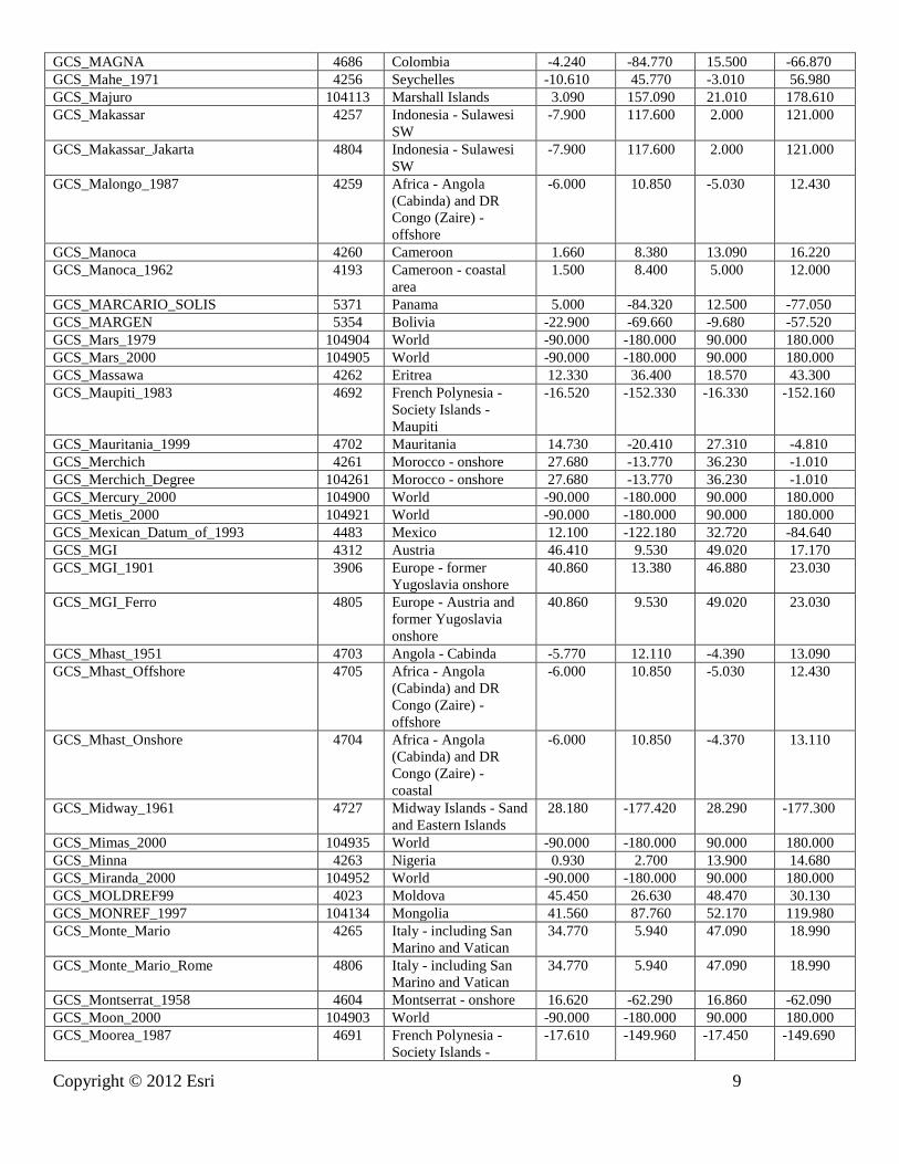
GCS_MAGNA 4686 Colombia -4.240 -84.770 15.500 -66.870
GCS_Mahe_1971 4256 Seychelles -10.610 45.770 -3.010 56.980
GCS_Majuro 104113 Marshall Islands 3.090 157.090 21.010 178.610
GCS_Makassar 4257 Indonesia - Sulawesi
SW
-7.900 117.600 2.000 121.000
GCS_Makassar_Jakarta 4804 Indonesia - Sulawesi
SW
-7.900 117.600 2.000 121.000
GCS_Malongo_1987 4259 Africa - Angola
(Cabinda) and DR
Congo (Zaire) -
offshore
-6.000 10.850 -5.030 12.430
GCS_Manoca 4260 Cameroon 1.660 8.380 13.090 16.220
GCS_Manoca_1962 4193 Cameroon - coastal
area
1.500 8.400 5.000 12.000
GCS_MARCARIO_SOLIS 5371 Panama 5.000 -84.320 12.500 -77.050
GCS_MARGEN 5354 Bolivia -22.900 -69.660 -9.680 -57.520
GCS_Mars_1979 104904 World -90.000 -180.000 90.000 180.000
GCS_Mars_2000 104905 World -90.000 -180.000 90.000 180.000
GCS_Massawa 4262 Eritrea 12.330 36.400 18.570 43.300
GCS_Maupiti_1983 4692 French Polynesia -
Society Islands -
Maupiti
-16.520 -152.330 -16.330 -152.160
GCS_Mauritania_1999 4702 Mauritania 14.730 -20.410 27.310 -4.810
GCS_Merchich 4261 Morocco - onshore 27.680 -13.770 36.230 -1.010
GCS_Merchich_Degree 104261 Morocco - onshore 27.680 -13.770 36.230 -1.010
GCS_Mercury_2000 104900 World -90.000 -180.000 90.000 180.000
GCS_Metis_2000 104921 World -90.000 -180.000 90.000 180.000
GCS_Mexican_Datum_of_1993 4483 Mexico 12.100 -122.180 32.720 -84.640
GCS_MGI 4312 Austria 46.410 9.530 49.020 17.170
GCS_MGI_1901 3906 Europe - former
Yugoslavia onshore
40.860 13.380 46.880 23.030
GCS_MGI_Ferro 4805 Europe - Austria and
former Yugoslavia
onshore
40.860 9.530 49.020 23.030
GCS_Mhast_1951 4703 Angola - Cabinda -5.770 12.110 -4.390 13.090
GCS_Mhast_Offshore 4705 Africa - Angola
(Cabinda) and DR
Congo (Zaire) -
offshore
-6.000 10.850 -5.030 12.430
GCS_Mhast_Onshore 4704 Africa - Angola
(Cabinda) and DR
Congo (Zaire) -
coastal
-6.000 10.850 -4.370 13.110
GCS_Midway_1961 4727 Midway Islands - Sand
and Eastern Islands
28.180 -177.420 28.290 -177.300
GCS_Mimas_2000 104935 World -90.000 -180.000 90.000 180.000
GCS_Minna 4263 Nigeria 0.930 2.700 13.900 14.680
GCS_Miranda_2000 104952 World -90.000 -180.000 90.000 180.000
GCS_MOLDREF99 4023 Moldova 45.450 26.630 48.470 30.130
GCS_MONREF_1997 104134 Mongolia 41.560 87.760 52.170 119.980
GCS_Monte_Mario 4265 Italy - including San
Marino and Vatican
34.770 5.940 47.090 18.990
GCS_Monte_Mario_Rome 4806 Italy - including San
Marino and Vatican
34.770 5.940 47.090 18.990
GCS_Montserrat_1958 4604 Montserrat - onshore 16.620 -62.290 16.860 -62.090
GCS_Moon_2000 104903 World -90.000 -180.000 90.000 180.000
GCS_Moorea_1987 4691 French Polynesia -
Society Islands -
-17.610 -149.960 -17.450 -149.690

10 Copyright © 2012 Esri
Moorea
GCS_MOP78 4639 Wallis and Futuna -
Wallis
-14.000 -177.000 -13.000 -176.000
GCS_Mount_Dillon 4157 Trinidad and Tobago -
Tobago - onshore
11.090 -60.890 11.400 -60.470
GCS_Moznet 4130 Mozambique -26.880 30.230 -9.560 43.000
GCS_Mporaloko 4266 Gabon -6.390 5.910 2.330 14.550
GCS_MSK_1942 104135 Mongolia 41.560 87.760 52.170 119.980
GCS_NAD_1927_CGQ77 4609 Canada - Quebec 44.990 -79.850 62.610 -57.110
GCS_NAD_1927_Definition_1976 4608 Canada - Ontario 41.680 -95.160 56.890 -74.360
GCS_NAD_1983_2011 104145 USA - CONUS and
Alaska; PRVI
14.930 167.650 74.710 -63.890
GCS_NAD_1983_CORS96 104223 USA - CONUS and
Alaska; PRVI
14.930 167.650 74.710 -63.890
GCS_NAD_1983_HARN_Adj_MN_
Anoka
104700 USA - Minnesota 43.500 -97.240 49.390 -89.470
GCS_NAD_1983_HARN_Adj_MN_
Becker
104701 USA - Minnesota 43.500 -97.240 49.390 -89.470
GCS_NAD_1983_HARN_Adj_MN_
Beltrami_North
104702 USA - Minnesota 43.500 -97.240 49.390 -89.470
GCS_NAD_1983_HARN_Adj_MN_
Beltrami_South
104703 USA - Minnesota 43.500 -97.240 49.390 -89.470
GCS_NAD_1983_HARN_Adj_MN_
Benton
104704 USA - Minnesota 43.500 -97.240 49.390 -89.470
GCS_NAD_1983_HARN_Adj_MN_Big_
Stone
104705 USA - Minnesota 43.500 -97.240 49.390 -89.470
GCS_NAD_1983_HARN_Adj_MN_Blue_
Earth
104706 USA - Minnesota 43.500 -97.240 49.390 -89.470
GCS_NAD_1983_HARN_Adj_MN_
Brown
104707 USA - Minnesota 43.500 -97.240 49.390 -89.470
GCS_NAD_1983_HARN_Adj_MN_
Carlton
104708 USA - Minnesota 43.500 -97.240 49.390 -89.470
GCS_NAD_1983_HARN_Adj_MN_
Carver
104709 USA - Minnesota 43.500 -97.240 49.390 -89.470
GCS_NAD_1983_HARN_Adj_MN_Cass_
North
104710 USA - Minnesota 43.500 -97.240 49.390 -89.470
GCS_NAD_1983_HARN_Adj_MN_Cass_
South
104711 USA - Minnesota 43.500 -97.240 49.390 -89.470
GCS_NAD_1983_HARN_Adj_MN_
Chippewa
104712 USA - Minnesota 43.500 -97.240 49.390 -89.470
GCS_NAD_1983_HARN_Adj_MN_Chisa
go
104713 USA - Minnesota 43.500 -97.240 49.390 -89.470
GCS_NAD_1983_HARN_Adj_MN_Cook
_North
104714 USA - Minnesota 43.500 -97.240 49.390 -89.470
GCS_NAD_1983_HARN_Adj_MN_Cook
_South
104715 USA - Minnesota 43.500 -97.240 49.390 -89.470
GCS_NAD_1983_HARN_Adj_MN_
Cottonwood
104716 USA - Minnesota 43.500 -97.240 49.390 -89.470
GCS_NAD_1983_HARN_Adj_MN_Crow
_Wing
104717 USA - Minnesota 43.500 -97.240 49.390 -89.470
GCS_NAD_1983_HARN_Adj_MN_Dako
ta
104718 USA - Minnesota 43.500 -97.240 49.390 -89.470
GCS_NAD_1983_HARN_Adj_MN_
Dodge
104719 USA - Minnesota 43.500 -97.240 49.390 -89.470
GCS_NAD_1983_HARN_Adj_MN_
Douglas
104720 USA - Minnesota 43.500 -97.240 49.390 -89.470
GCS_NAD_1983_HARN_Adj_MN_
Faribault
104721 USA - Minnesota 43.500 -97.240 49.390 -89.470

Copyright © 2012 Esri 11
GCS_NAD_1983_HARN_Adj_MN_
Fillmore
104722 USA - Minnesota 43.500 -97.240 49.390 -89.470
GCS_NAD_1983_HARN_Adj_MN_
Freeborn
104723 USA - Minnesota 43.500 -97.240 49.390 -89.470
GCS_NAD_1983_HARN_Adj_MN_Good
hue
104724 USA - Minnesota 43.500 -97.240 49.390 -89.470
GCS_NAD_1983_HARN_Adj_MN_Grant 104725 USA - Minnesota 43.500 -97.240 49.390 -89.470
GCS_NAD_1983_HARN_Adj_MN_
Hennepin
104726 USA - Minnesota 43.500 -97.240 49.390 -89.470
GCS_NAD_1983_HARN_Adj_MN_
Houston
104727 USA - Minnesota 43.500 -97.240 49.390 -89.470
GCS_NAD_1983_HARN_Adj_MN_Isanti 104728 USA - Minnesota 43.500 -97.240 49.390 -89.470
GCS_NAD_1983_HARN_Adj_MN_Itasca
_North
104729 USA - Minnesota 43.500 -97.240 49.390 -89.470
GCS_NAD_1983_HARN_Adj_MN_Itasca
_South
104730 USA - Minnesota 43.500 -97.240 49.390 -89.470
GCS_NAD_1983_HARN_Adj_MN_
Jackson
104731 USA - Minnesota 43.500 -97.240 49.390 -89.470
GCS_NAD_1983_HARN_Adj_MN_Kana
bec
104732 USA - Minnesota 43.500 -97.240 49.390 -89.470
GCS_NAD_1983_HARN_Adj_MN_
Kandiyohi
104733 USA - Minnesota 43.500 -97.240 49.390 -89.470
GCS_NAD_1983_HARN_Adj_MN_
Kittson
104734 USA - Minnesota 43.500 -97.240 49.390 -89.470
GCS_NAD_1983_HARN_Adj_MN_
Koochiching
104735 USA - Minnesota 43.500 -97.240 49.390 -89.470
GCS_NAD_1983_HARN_Adj_MN_Lac_
Qui_Parle
104736 USA - Minnesota 43.500 -97.240 49.390 -89.470
GCS_NAD_1983_HARN_Adj_MN_Lake
_of_the_Woods_North
104737 USA - Minnesota 43.500 -97.240 49.390 -89.470
GCS_NAD_1983_HARN_Adj_MN_Lake
_of_the_Woods_South
104738 USA - Minnesota 43.500 -97.240 49.390 -89.470
GCS_NAD_1983_HARN_Adj_MN_Le_
Sueur
104739 USA - Minnesota 43.500 -97.240 49.390 -89.470
GCS_NAD_1983_HARN_Adj_MN_
Lincoln
104740 USA - Minnesota 43.500 -97.240 49.390 -89.470
GCS_NAD_1983_HARN_Adj_MN_Lyon 104741 USA - Minnesota 43.500 -97.240 49.390 -89.470
GCS_NAD_1983_HARN_Adj_MN_
Mahnomen
104743 USA - Minnesota 43.500 -97.240 49.390 -89.470
GCS_NAD_1983_HARN_Adj_MN_
Marshall
104744 USA - Minnesota 43.500 -97.240 49.390 -89.470
GCS_NAD_1983_HARN_Adj_MN_
Martin
104745 USA - Minnesota 43.500 -97.240 49.390 -89.470
GCS_NAD_1983_HARN_Adj_MN_
McLeod
104742 USA - Minnesota 43.500 -97.240 49.390 -89.470
GCS_NAD_1983_HARN_Adj_MN_Meek
er
104746 USA - Minnesota 43.500 -97.240 49.390 -89.470
GCS_NAD_1983_HARN_Adj_MN_Morri
son
104747 USA - Minnesota 43.500 -97.240 49.390 -89.470
GCS_NAD_1983_HARN_Adj_MN_Mow
er
104748 USA - Minnesota 43.500 -97.240 49.390 -89.470
GCS_NAD_1983_HARN_Adj_MN_
Murray
104749 USA - Minnesota 43.500 -97.240 49.390 -89.470
GCS_NAD_1983_HARN_Adj_MN_Nicol
let
104750 USA - Minnesota 43.500 -97.240 49.390 -89.470
GCS_NAD_1983_HARN_Adj_MN_
Nobles
104751 USA - Minnesota 43.500 -97.240 49.390 -89.470
GCS_NAD_1983_HARN_Adj_MN_ 104752 USA - Minnesota 43.500 -97.240 49.390 -89.470

12 Copyright © 2012 Esri
Norman
GCS_NAD_1983_HARN_Adj_MN_
Olmsted
104753 USA - Minnesota 43.500 -97.240 49.390 -89.470
GCS_NAD_1983_HARN_Adj_MN_
Ottertail
104754 USA - Minnesota 43.500 -97.240 49.390 -89.470
GCS_NAD_1983_HARN_Adj_MN_
Pennington
104755 USA - Minnesota 43.500 -97.240 49.390 -89.470
GCS_NAD_1983_HARN_Adj_MN_Pine 104756 USA - Minnesota 43.500 -97.240 49.390 -89.470
GCS_NAD_1983_HARN_Adj_MN_
Pipestone
104757 USA - Minnesota 43.500 -97.240 49.390 -89.470
GCS_NAD_1983_HARN_Adj_MN_Polk 104758 USA - Minnesota 43.500 -97.240 49.390 -89.470
GCS_NAD_1983_HARN_Adj_MN_Pope 104759 USA - Minnesota 43.500 -97.240 49.390 -89.470
GCS_NAD_1983_HARN_Adj_MN_
Ramsey
104760 USA - Minnesota 43.500 -97.240 49.390 -89.470
GCS_NAD_1983_HARN_Adj_MN_Red_
Lake
104761 USA - Minnesota 43.500 -97.240 49.390 -89.470
GCS_NAD_1983_HARN_Adj_MN_
Redwood
104762 USA - Minnesota 43.500 -97.240 49.390 -89.470
GCS_NAD_1983_HARN_Adj_MN_
Renville
104763 USA - Minnesota 43.500 -97.240 49.390 -89.470
GCS_NAD_1983_HARN_Adj_MN_Rice 104764 USA - Minnesota 43.500 -97.240 49.390 -89.470
GCS_NAD_1983_HARN_Adj_MN_Rock 104765 USA - Minnesota 43.500 -97.240 49.390 -89.470
GCS_NAD_1983_HARN_Adj_MN_
Roseau
104766 USA - Minnesota 43.500 -97.240 49.390 -89.470
GCS_NAD_1983_HARN_Adj_MN_Scott 104770 USA - Minnesota 43.500 -97.240 49.390 -89.470
GCS_NAD_1983_HARN_Adj_MN_
Sherburne
104771 USA - Minnesota 43.500 -97.240 49.390 -89.470
GCS_NAD_1983_HARN_Adj_MN_
Sibley
104772 USA - Minnesota 43.500 -97.240 49.390 -89.470
GCS_NAD_1983_HARN_Adj_MN_
Stearns
104773 USA - Minnesota 43.500 -97.240 49.390 -89.470
GCS_NAD_1983_HARN_Adj_MN_
Steele
104774 USA - Minnesota 43.500 -97.240 49.390 -89.470
GCS_NAD_1983_HARN_Adj_MN_
Stevens
104775 USA - Minnesota 43.500 -97.240 49.390 -89.470
GCS_NAD_1983_HARN_Adj_MN_St_
Louis
104786 USA - Minnesota 43.500 -97.240 49.390 -89.470
GCS_NAD_1983_HARN_Adj_MN_St_
Louis_Central
104768 USA - Minnesota 43.500 -97.240 49.390 -89.470
GCS_NAD_1983_HARN_Adj_MN_St_
Louis_North
104767 USA - Minnesota 43.500 -97.240 49.390 -89.470
GCS_NAD_1983_HARN_Adj_MN_St_
Louis_South
104769 USA - Minnesota 43.500 -97.240 49.390 -89.470
GCS_NAD_1983_HARN_Adj_MN_Swift 104776 USA - Minnesota 43.500 -97.240 49.390 -89.470
GCS_NAD_1983_HARN_Adj_MN_Todd 104777 USA - Minnesota 43.500 -97.240 49.390 -89.470
GCS_NAD_1983_HARN_Adj_MN_
Traverse
104778 USA - Minnesota 43.500 -97.240 49.390 -89.470
GCS_NAD_1983_HARN_Adj_MN_Waba
sha
104779 USA - Minnesota 43.500 -97.240 49.390 -89.470
GCS_NAD_1983_HARN_Adj_MN_Wade
na
104780 USA - Minnesota 43.500 -97.240 49.390 -89.470
GCS_NAD_1983_HARN_Adj_MN_Wase
ca
104781 USA - Minnesota 43.500 -97.240 49.390 -89.470
GCS_NAD_1983_HARN_Adj_MN_
Watonwan
104782 USA - Minnesota 43.500 -97.240 49.390 -89.470
GCS_NAD_1983_HARN_Adj_MN_Wino
na
104783 USA - Minnesota 43.500 -97.240 49.390 -89.470
GCS_NAD_1983_HARN_Adj_MN_ 104784 USA - Minnesota 43.500 -97.240 49.390 -89.470

Copyright © 2012 Esri 13
Wright
GCS_NAD_1983_HARN_Adj_MN_
Yellow_Medicine
104785 USA - Minnesota 43.500 -97.240 49.390 -89.470
GCS_NAD_1983_MA11 104286 Pacific Ocean -78.800 99.300 65.600 -70.000
GCS_NAD_1983_MARP00 104260 Pacific Ocean -78.800 99.300 65.600 -70.000
GCS_NAD_1983_NSRS2007 4759 USA - CONUS and
Alaska; PRVI
14.930 167.650 74.710 -63.890
GCS_NAD_1983_PA11 104287 Pacific Ocean -78.800 99.300 65.600 -70.000
GCS_NAD_1983_PACP00 104259 Pacific Ocean -78.800 99.300 65.600 -70.000
GCS_Nahrwan_1934 4744 Asia - Middle East -
SE Iraq and SW Iran
29.000 44.300 33.500 50.830
GCS_Nahrwan_1967 4270 Asia - Middle East -
Nahrwan
22.630 38.820 37.410 56.380
GCS_Naiad_2000 104964 World -90.000 -180.000 90.000 180.000
GCS_Nakhl-e_Ghanem 4693 Iran - Kangan district 27.700 51.800 28.200 52.500
GCS_Naparima_1955 4158 Trinidad and Tobago -
Trinidad - onshore
9.990 -61.970 10.890 -60.860
GCS_Naparima_1972 4271 Trinidad and Tobago -
Tobago - onshore
11.090 -60.890 11.400 -60.470
GCS_NEA74_Noumea 4644 New Caledonia -
Grande Terre -
Noumea
-22.350 166.300 -22.100 166.500
GCS_Nepal_Nagarkot 104256 Nepal 26.360 80.100 30.460 88.250
GCS_Neptune_2000 104960 World -90.000 -180.000 90.000 180.000
GCS_Nereid_2000 104965 World -90.000 -180.000 90.000 180.000
GCS_New_Beijing 4555 China - onshore 18.040 73.660 53.590 134.850
GCS_New_Zealand_1949 4272 New Zealand -
onshore and nearshore
-47.400 166.330 -34.000 178.600
GCS_NGN 4318 Kuwait - onshore 28.560 46.570 30.100 48.450
GCS_NGO_1948 4273 Norway - onshore 57.940 4.690 71.200 31.220
GCS_NGO_1948_Oslo 4817 Norway - onshore 57.940 4.690 71.200 31.220
GCS_Nord_de_Guerre_Paris 4902 France - Alsace 47.420 6.850 49.070 8.230
GCS_Nord_Sahara_1959 4307 Algeria - north of
32~N
32.000 -2.920 37.090 9.090
GCS_Nord_Sahara_1959_Paris 4819 Africa - Algeria,
Morocco and Tunisia
18.980 -13.170 37.340 11.990
GCS_North_American_1927 4267 North America -
NAD27
7.980 167.650 83.160 -47.740
GCS_North_American_1983 4269 North America -
NAD83
14.930 167.650 86.450 -47.740
GCS_North_American_1983_CSRS 4617 Canada 40.040 -141.000 86.450 -47.740
GCS_North_American_1983_HARN 4152 USA - HARN -14.580 144.580 49.380 -64.510
GCS_Nouakchott_1965 4680 Mauritania - central
coast
17.300 -16.670 19.360 -15.750
GCS_NSWC_9Z_2 4276 World -90.000 -180.000 90.000 180.000
GCS_NTF 4275 France - onshore -
mainland and Corsica
41.310 -4.870 51.140 9.630
GCS_NTF_Paris 4807 France - onshore -
mainland and Corsica
41.310 -4.870 51.140 9.630
GCS_NWL_9D 4025 Not specified -90.000 -180.000 90.000 180.000
GCS_NZGD_2000 4167 New Zealand -55.950 157.410 -22.740 -170.890
GCS_Oberon_2000 104953 World -90.000 -180.000 90.000 180.000
GCS_Observatario 4129 Mozambique - south -26.880 31.300 -19.750 35.600
GCS_Observatorio_Meteorologico_1939 37245 Portugal - Azores W -
onshore
39.300 -31.340 39.760 -31.020
GCS_Observatorio_Meteorologico_1965 104126 China - Macao 22.090 113.590 22.310 113.690
GCS_Ocotepeque_1935 5451 Costa Rica 2.150 -90.440 11.770 -81.430
GCS_Old_Hawaiian 4135 USA - Hawaii - 18.880 -160.300 22.290 -154.750

14 Copyright © 2012 Esri
onshore
GCS_Old_Hawaiian_Intl_1924 104138 USA - Hawaii -
onshore
18.880 -160.300 22.290 -154.750
GCS_Oman 37206 Oman 14.010 51.900 26.750 63.050
GCS_Ophelia_2000 104954 World -90.000 -180.000 90.000 180.000
GCS_OSGB_1936 4277 UK - Great Britain;
Isle of Man
49.810 -8.730 60.890 1.830
GCS_OSGB_1970_SN 4278 UK - Great Britain;
Isle of Man
49.810 -8.730 60.890 1.830
GCS_OSNI_1952 4188 UK - Northern Ireland
- onshore
53.960 -8.170 55.350 -5.350
GCS_OS_SN_1980 4279 Europe - British Isles -
UK and Ireland
onshore
49.810 -10.560 60.890 1.830
GCS_OSU_86F 4032 Not specified -90.000 -180.000 90.000 180.000
GCS_OSU_91A 4033 Not specified -90.000 -180.000 90.000 180.000
GCS_Padang_1884 4280 Indonesia - Sumatra -6.500 95.000 6.000 108.550
GCS_Padang_1884_Jakarta 4808 Indonesia - Sumatra -6.500 95.000 6.000 108.550
GCS_Palestine_1923 4281 Asia - Middle East -
Israel, Jordan and
Palestine onshore
29.190 34.220 33.380 39.300
GCS_Pampa_del_Castillo 4161 Argentina - Comodoro
Rivadavia
-46.700 -69.500 -45.200 -67.100
GCS_Pan_2000 104936 World -90.000 -180.000 90.000 180.000
GCS_Panama-Colon_1911 5467 Panama - onshore 7.160 -83.030 9.670 -77.200
GCS_Pandora_2000 104937 World -90.000 -180.000 90.000 180.000
GCS_Pasiphae_2000 104922 World -90.000 -180.000 90.000 180.000
GCS_PD/83 4746 Germany - Thuringen 50.200 9.920 51.640 12.560
GCS_PDO_1993 4134 Oman - onshore 16.600 51.900 26.400 59.890
GCS_Peru96 5373 Peru -21.050 -84.670 -0.040 -68.670
GCS_Petrels_1972 4636 Antarctica - Adelie
Land - Petrels island
-66.900 139.500 -66.500 140.500
GCS_Phobos_2000 104907 World -90.000 -180.000 90.000 180.000
GCS_Phoebe_2000 104938 World -90.000 -180.000 90.000 180.000
GCS_Pico_de_Las_Nieves 4728 Spain - Canary Islands
onshore
27.590 -18.220 29.290 -13.370
GCS_Pitcairn_1967 4729 Pitcairn - Pitcairn
Island
-25.160 -130.180 -25.000 -129.990
GCS_Pitcairn_2006 4763 Pitcairn - Pitcairn
Island
-25.160 -130.180 -25.000 -129.990
GCS_Plessis_1817 4027 Not specified -90.000 -180.000 90.000 180.000
GCS_Pluto_2000 104969 World -90.000 -180.000 90.000 180.000
GCS_PNG94 5546 Papua New Guinea
(PNG)
-12.010 140.930 2.600 164.100
GCS_Pohnpei 104109 Micronesia 0.000 136.660 12.760 168.430
GCS_Point_58 4620 Africa - 12th parallel
N
10.000 -16.810 14.000 22.970
GCS_Pointe_Geologie_Perroud_1950 4637 Antarctica - Adelie
Land
-68.000 135.000 -66.000 142.000
GCS_Pointe_Noire 4282 Congo -7.130 8.870 3.720 18.650
GCS_Portia_2000 104955 World -90.000 -180.000 90.000 180.000
GCS_Porto_Santo_1936 4615 Portugal - Madeira
archipelago onshore
32.360 -17.300 33.140 -16.230
GCS_Porto_Santo_1995 4663 Portugal - Madeira
archipelago onshore
32.360 -17.300 33.140 -16.230
GCS_POSGAR 4172 Argentina -58.400 -73.580 -21.780 -52.630
GCS_POSGAR_1994 4694 Argentina -58.400 -73.580 -21.780 -52.630
GCS_POSGAR_1998 4190 Argentina -58.400 -73.580 -21.780 -52.630

Copyright © 2012 Esri 15
GCS_POSGAR_2007 5340 Argentina -58.400 -73.580 -21.780 -52.630
GCS_Principe 4824 Sao Tome and
Principe - onshore -
Principe
1.300 7.250 1.710 7.490
GCS_Prometheus_2000 104939 World -90.000 -180.000 90.000 180.000
GCS_Proteus_2000 104966 World -90.000 -180.000 90.000 180.000
GCS_Provisional_S_American_1956 4248 South America -
PSAD56 by country
-45.000 -81.400 12.680 -48.000
GCS_PRS_1992 4683 Philippines 2.250 116.090 21.430 140.080
GCS_PTRA08 5013 Portugal - Azores and
Madeira
Archipelagoes
32.390 -31.300 39.750 -16.250
GCS_Puck_2000 104956 World -90.000 -180.000 90.000 180.000
GCS_Puerto_Rico 4139 Caribbean - Puerto
Rico and Virgin
Islands - onshore
17.630 -67.960 18.770 -64.250
GCS_Pulkovo_1942 4284 Europe - FSU onshore 35.150 19.580 81.900 -169.570
GCS_Pulkovo_1942_Adj_1958 4179 Europe - onshore -
eastern - S-42(58)
39.640 9.920 54.890 29.730
GCS_Pulkovo_1942_Adj_1983 4178 Europe - onshore -
eastern - S-42(58)
39.640 9.920 54.890 29.730
GCS_Pulkovo_1995 4200 Russia 39.880 18.930 85.190 -168.970
GCS_PZ_1990 4740 World -90.000 -180.000 90.000 180.000
GCS_Qatar_1948 4286 Qatar - onshore 24.480 50.750 26.180 51.640
GCS_Qatar_1974 4285 Qatar - onshore 24.480 50.750 26.180 51.640
GCS_QND_1995 4614 Qatar - onshore 24.480 50.750 26.180 51.640
GCS_Qornoq_1927 4194 Greenland - west coast 59.740 -73.280 79.000 -42.520
GCS_Rassadiran 4153 Iran - Taheri refinery 27.400 52.500 27.600 52.700
GCS_RD/83 4745 Germany - Sachsen 50.210 11.900 51.660 15.030
GCS_REGCAN95 4081 Spain - Canary Islands 24.600 -21.930 32.750 -11.750
GCS_REGVEN 4189 Venezuela 0.650 -73.380 16.750 -58.950
GCS_Reunion_1947 4626 Reunion - onshore -21.400 55.200 -20.800 55.800
GCS_Reykjavik_1900 4657 Iceland - onshore 63.350 -24.660 66.580 -13.380
GCS_RGAF09 5489 Caribbean - French
Antilles
14.080 -63.660 18.530 -57.530
GCS_RGF_1993 4171 France 41.150 -9.860 51.560 10.380
GCS_RGFG_1995 4624 French Guiana 2.110 -54.600 8.880 -49.460
GCS_RGM_2004 4470 Mayotte -14.370 44.130 -11.320 45.770
GCS_RGNC_1991 4645 New Caledonia -23.460 157.090 -17.260 173.890
GCS_RGNC_1991-93 4749 New Caledonia -23.460 157.090 -17.260 173.890
GCS_RGPF 4687 French Polynesia -29.000 -155.000 -7.000 -132.000
GCS_RGR_1992 4627 Reunion -25.920 37.580 -10.600 58.270
GCS_RGRDC_2005 4046 Congo DR (Zaire) -
south
-13.460 28.500 -3.300 30.780
GCS_RGSPM_2006 4463 St Pierre and
Miquelon
43.420 -57.100 47.370 -55.900
GCS_Rhea_2000 104940 World -90.000 -180.000 90.000 180.000
GCS_Roma_1940 104127 Italy - including San
Marino and Vatican
34.770 5.940 47.090 18.990
GCS_Rosalind_2000 104957 World -90.000 -180.000 90.000 180.000
GCS_RRAF_1991 4558 Caribbean - French
Antilles
14.080 -63.660 18.530 -57.530
GCS_RSRGD2000 4764 Antarctica - Ross Sea
Region
-90.000 145.000 -60.000 -140.000
GCS_RT_1990 4124 Sweden 54.960 10.030 69.060 24.170
GCS_RT38 4308 Sweden - onshore 55.290 10.940 69.060 24.170
GCS_RT38_Stockholm 4814 Sweden - onshore 55.290 10.940 69.060 24.170
GCS_S42_Hungary 37257 Hungary 45.750 16.110 48.580 22.890

16 Copyright © 2012 Esri
GCS_SAD_1969_96 5527 Brazil - SAD69 -35.710 -60.570 7.040 -29.030
GCS_Sainte_Anne 4622 Guadeloupe - Grande-
Terre and surrounding
islands - onshore
15.800 -61.850 16.540 -60.970
GCS_Saint_Pierre_et_Miquelon_1950 4638 St Pierre and
Miquelon - onshore
46.700 -56.470 47.180 -56.070
GCS_Samboja 4125 Indonesia -
Kalimantan E -
Mahakam delta
-1.350 116.900 0.000 118.000
GCS_Santo_DOS_1965 4730 Vanuatu - northern
islands
-17.400 166.500 -14.610 168.310
GCS_Sao_Braz 37249 Portugal - Azores E -
onshore
36.880 -25.910 37.960 -24.960
GCS_Sao_Tome 4823 Sao Tome and
Principe - onshore -
Sao Tome
-0.020 6.440 0.450 6.800
GCS_Sapper_Hill_1943 4292 Falkland Islands -
onshore
-52.390 -61.230 -51.200 -57.650
GCS_Saturn_2000 104925 World -90.000 -180.000 90.000 180.000
GCS_Schwarzeck 4293 Namibia -31.200 8.320 -16.990 25.280
GCS_Scoresbysund_1952 4195 Greenland -
Scoresbysund area
68.660 -29.680 74.580 -19.890
GCS_Segora 4294 Indonesia -
Kalimantan SE
-5.720 114.000 2.500 118.000
GCS_Selvagem_Grande_1938 4616 Portugal - Selvagens
onshore
29.980 -16.100 30.200 -15.790
GCS_Serindung 4295 Indonesia -
Kalimantan E
-5.720 113.690 4.400 119.620
GCS_Sibun_Gorge_1922 5464 Belize - onshore 15.890 -89.220 18.490 -87.730
GCS_Sierra_Leone_1924 4174 Sierra Leone -
Freetown Peninsula
8.100 -13.330 8.600 -13.000
GCS_Sierra_Leone_1960 104103 Sierra Leone 4.270 -15.680 10.000 -10.270
GCS_Sierra_Leone_1968 4175 Sierra Leone - onshore 6.890 -13.300 10.000 -10.270
GCS_Sinope_2000 104923 World -90.000 -180.000 90.000 180.000
GCS_SIRGAS 4170 South America -
SIRGAS 1995 by
country
-59.860 -113.200 16.750 -26.010
GCS_SIRGAS_2000 4674 Latin America -
SIRGAS 2000 by
country
-59.860 -122.180 32.720 -26.010
GCS_SIRGAS-Chile 5360 Chile -59.860 -113.200 -17.510 -65.730
GCS_SIRGAS_ES2007.8 5393 El Salvador 9.970 -91.420 14.430 -87.650
GCS_SIRGAS-ROU98 5381 Uruguay -37.770 -58.490 -30.100 -50.010
GCS_S_JTSK 4156 Europe -
Czechoslovakia
47.740 12.090 51.050 22.560
GCS_S_JTSK/05 5228 Czech Republic 48.580 12.090 51.050 18.850
GCS_S_JTSK/05_Ferro 5229 Czech Republic 48.580 12.090 51.050 18.850
GCS_S_JTSK_Ferro 4818 Europe -
Czechoslovakia
47.740 12.090 51.050 22.560
GCS_SLD99 5233 Sri Lanka - onshore 5.850 79.600 9.920 81.950
GCS_Slovenia_1996 4765 Slovenia 45.430 13.380 46.880 16.610
GCS_Solomon_1968 4718 Solomon Islands -13.260 154.090 -3.500 171.100
GCS_South_American_1969 4618 South America -
SAD69 by country
-45.000 -81.400 12.510 -29.030
GCS_South_Asia_Singapore 37207 Singapore 1.120 103.620 1.460 104.160
GCS_South_Yemen 4164 Yemen - South Yemen 12.000 42.500 15.000 53.000
GCS_Sphere 4035 Not specified -90.000 -180.000 90.000 180.000
GCS_Sphere_ARC_INFO 37008 World -90.000 -180.000 90.000 180.000

Copyright © 2012 Esri 17
GCS_Sphere_Clarke_1866_Authalic 4052 Not specified -90.000 -180.000 90.000 180.000
GCS_Sphere_EMEP 104128 Europe - LCC &
LAEA
24.600 -35.580 84.160 44.820
GCS_Sphere_GRS_1980_Authalic 4047 Not specified -90.000 -180.000 90.000 180.000
GCS_Sphere_International_1924_Authalic 4053 Not specified -90.000 -180.000 90.000 180.000
GCS_SREF98 4075 Serbia 41.860 18.820 46.180 23.010
GCS_ST71_Belep 4643 New Caledonia -
Belep
-19.850 163.550 -19.540 163.700
GCS_ST84_Ile_des_Pins 4642 New Caledonia - Ile
des Pins
-22.750 167.300 -22.500 167.550
GCS_ST87_Ouvea 4750 New Caledonia -
Ouvea
-20.750 166.350 -20.350 166.700
GCS_St_George_Island 4138 USA - Alaska - St.
George Island
56.490 -169.870 56.660 -169.380
GCS_St_Kitts_1955 4605 St Kitts and Nevis -
onshore
17.070 -62.910 17.460 -62.500
GCS_St_Lawrence_Island 4136 USA - Alaska - St.
Lawrence Island
62.900 -171.960 63.830 -168.590
GCS_St_Lucia_1955 4606 St Lucia - onshore 13.660 -61.130 14.160 -60.830
GCS_St_Paul_Island 4137 USA - Alaska - St.
Paul Island
57.060 -170.500 57.270 -170.050
GCS_Struve_1860 4028 Not specified -90.000 -180.000 90.000 180.000
GCS_St_Vincent_1945 4607 St Vincent and the
Grenadines - onshore
12.550 -61.510 13.430 -61.070
GCS_Sudan 4296 Sudan 8.750 21.840 22.250 39.410
GCS_SVY21 4757 Singapore 1.120 103.620 1.460 104.160
GCS_SWEREF99 4619 Sweden 54.960 10.030 69.060 24.170
GCS_Swiss_TRF_1995 4151 Europe - Liechtenstein
and Switzerland
45.830 5.970 47.810 10.490
GCS_Tahaa_1954 4629 French Polynesia -
Society Islands - Bora
Bora, Huahine,
Raiatea, Tahaa
-16.950 -151.800 -16.620 -150.900
GCS_Tahiti_1952 4628 French Polynesia -
Society Islands -
Moorea and Tahiti
-17.910 -149.960 -17.450 -149.070
GCS_Tahiti_1979 4690 French Polynesia -
Society Islands -
Tahiti
-17.910 -149.690 -17.450 -149.070
GCS_Tananarive_1925 4297 Madagascar -28.890 41.140 -10.600 55.340
GCS_Tananarive_1925_Paris 4810 Madagascar -28.890 41.140 -10.600 55.340
GCS_Telesto_2000 104941 World -90.000 -180.000 90.000 180.000
GCS_Tern_Island_1961 4707 USA - Hawaii - Tern
Island and Sorel Atoll
23.690 -166.360 23.930 -166.030
GCS_Tete 4127 Mozambique -
onshore
-26.880 30.230 -10.400 40.900
GCS_Tethys_2000 104942 World -90.000 -180.000 90.000 180.000
GCS_Thalassa_2000 104967 World -90.000 -180.000 90.000 180.000
GCS_Thebe_2000 104924 World -90.000 -180.000 90.000 180.000
GCS_Timbalai_1948 4298 Asia - Brunei and East
Malaysia
0.850 109.550 7.350 119.260
GCS_Titan_2000 104943 World -90.000 -180.000 90.000 180.000
GCS_Titania_2000 104958 World -90.000 -180.000 90.000 180.000
GCS_TM65 4299 Europe - Ireland
(Republic and Ulster) -
onshore
51.400 -10.560 55.430 -5.350
GCS_TM75 4300 Europe - Ireland
(Republic and Ulster) -
51.400 -10.560 55.430 -5.350
18 Copyright © 2012 Esri
onshore
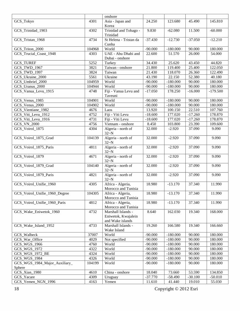
GCS_Tokyo 4301 Asia - Japan and
Korea
24.250 123.680 45.490 145.810
GCS_Trinidad_1903 4302 Trinidad and Tobago -
Trinidad
9.830 -62.080 11.500 -60.000
GCS_Tristan_1968 4734 St Helena - Tristan da
Cunha
-37.430 -12.730 -37.050 -12.210
GCS_Triton_2000 104968 World -90.000 -180.000 90.000 180.000
GCS_Trucial_Coast_1948 4303 UAE - Abu Dhabi and
Dubai - onshore
22.600 51.570 26.000 54.000
GCS_TUREF 5252 Turkey 34.430 25.620 43.450 44.820
GCS_TWD_1967 3821 Taiwan - onshore 21.800 119.400 25.400 122.050
GCS_TWD_1997 3824 Taiwan 21.430 118.070 26.360 122.490
GCS_Ukraine_2000 5561 Ukraine 43.190 22.150 52.380 40.180
GCS_Umbriel_2000 104959 World -90.000 -180.000 90.000 180.000
GCS_Uranus_2000 104944 World -90.000 -180.000 90.000 180.000
GCS_Vanua_Levu_1915 4748 Fiji - Vanua Levu and
Taveuni
-17.050 178.250 -16.000 -179.500
GCS_Venus_1985 104901 World -90.000 -180.000 90.000 180.000
GCS_Venus_2000 104902 World -90.000 -180.000 90.000 180.000
GCS_Vientiane_1982 4676 Laos 13.920 100.150 22.510 107.760
GCS_Viti_Levu_1912 4752 Fiji - Viti Levu -18.600 177.020 -17.260 178.870
GCS_Viti_Levu_1916 4731 Fiji - Viti Levu -18.600 177.020 -17.260 178.870
GCS_VN_2000 4756 Vietnam - onshore 8.450 103.800 23.390 109.600
GCS_Voirol_1875 4304 Algeria - north of
32~N
32.000 -2.920 37.090 9.090
GCS_Voirol_1875_Grad 104139 Algeria - north of
32~N
32.000 -2.920 37.090 9.090
GCS_Voirol_1875_Paris 4811 Algeria - north of
32~N
32.000 -2.920 37.090 9.090
GCS_Voirol_1879 4671 Algeria - north of
32~N
32.000 -2.920 37.090 9.090
GCS_Voirol_1879_Grad 104140 Algeria - north of
32~N
32.000 -2.920 37.090 9.090
GCS_Voirol_1879_Paris 4821 Algeria - north of
32~N
32.000 -2.920 37.090 9.090
GCS_Voirol_Unifie_1960 4305 Africa - Algeria,
Morocco and Tunisia
18.980 -13.170 37.340 11.990
GCS_Voirol_Unifie_1960_Degree 104305 Africa - Algeria,
Morocco and Tunisia
18.980 -13.170 37.340 11.990
GCS_Voirol_Unifie_1960_Paris 4812 Africa - Algeria,
Morocco and Tunisia
18.980 -13.170 37.340 11.990
GCS_Wake_Eniwetok_1960 4732 Marshall Islands -
Eniwetok, Kwajalein
and Wake islands
8.640 162.030 19.340 168.000
GCS_Wake_Island_1952 4733 Marshall Islands -
Wake Island
19.260 166.580 19.340 166.660
GCS_Walbeck 37007 World -90.000 -180.000 90.000 180.000
GCS_War_Office 4029 Not specified -90.000 -180.000 90.000 180.000
GCS_WGS_1966 4760 World -90.000 -180.000 90.000 180.000
GCS_WGS_1972 4322 World -90.000 -180.000 90.000 180.000
GCS_WGS_1972_BE 4324 World -90.000 -180.000 90.000 180.000
GCS_WGS_1984 4326 World -90.000 -180.000 90.000 180.000
GCS_WGS_1984_Major_Auxiliary_
Sphere
104199 World -90.000 -180.000 90.000 180.000
GCS_Xian_1980 4610 China - onshore 18.040 73.660 53.590 134.850
GCS_Yacare 4309 Uruguay -37.770 -58.490 -30.100 -50.010
GCS_Yemen_NGN_1996 4163 Yemen 11.610 41.440 19.010 55.030

Copyright © 2012 Esri 19
GCS_Yoff 4310 Senegal 9.500 -20.210 16.700 -11.370
GCS_Zanderij 4311 Suriname 1.840 -58.070 9.350 -52.660
Table 2: Geographic coordinate systems: non-Greenwich or non-degree definitions GCS Name WKID Prime Meridian Angular Unit
GCS_ATF_Paris 4901 Paris Grad
GCS_Batavia_Jakarta 4813 Jakarta Degree
GCS_Belge_1950_Brussels 4809 Brussels Degree
GCS_Bern_1898_Bern 4801 Bern Degree
GCS_Bogota_Bogota 4802 Bogota Degree
GCS_Carthage_Grad 37225 Greenwich Grad
GCS_Carthage_Paris 4816 Paris Grad
GCS_Greek_Athens 4815 Athens Degree
GCS_Gunung_Segara_Jakarta 4820 Jakarta Degree
GCS_Lisbon_1890_Lisbon 4904 Lisbon Degree
GCS_Lisbon_Lisbon 4803 Lisbon Degree
GCS_Madrid_1870_Madrid 4903 Madrid Degree
GCS_Makassar_Jakarta 4804 Jakarta Degree
GCS_Merchich 4261 Greenwich Grad
GCS_MGI_Ferro 4805 Ferro Degree
GCS_Monte_Mario_Rome 4806 Rome Degree
GCS_NGO_1948_Oslo 4817 Oslo Degree
GCS_Nord_de_Guerre_Paris 4902 Paris Grad
GCS_Nord_Sahara_1959_Paris 4819 Paris Grad
GCS_NTF_Paris 4807 Paris Grad
GCS_Padang_1884_Jakarta 4808 Jakarta Degree
GCS_RT38_Stockholm 4814 Stockholm Degree
GCS_S_JTSK/05_Ferro 5229 Ferro Degree
GCS_S_JTSK_Ferro 4818 Ferro Degree
GCS_Tananarive_1925_Paris 4810 Paris Grad
GCS_Voirol_1875_Grad 104139 Greenwich Grad
GCS_Voirol_1875_Paris 4811 Paris Grad
GCS_Voirol_1879_Grad 104140 Greenwich Grad
GCS_Voirol_1879_Paris 4821 Paris Grad
GCS_Voirol_Unifie_1960 4305 Greenwich Grad
GCS_Voirol_Unifie_1960_Paris 4812 Paris Grad
Table 3: Geodetic datums: well -known IDs and spheroids Datum Name WKID Spheroid Name
D_Abidjan_1987 6143 Clarke_1880_RGS
D_Accra 6168 War_Office
D_Adindan 6201 Clarke_1880_RGS
D_Adrastea_2000 106909 Adrastea_2000_IAU_IAG
D_Afgooye 6205 Krasovsky_1940
D_Agadez 6206 Clarke_1880_IGN
D_Ain_el_Abd_1970 6204 International_1924
D_Airy_1830 6001 Airy_1830
D_Airy_Modified 6002 Airy_Modified
D_Alaskan_Islands 106260 Clarke_1866
D_Albanian_1987 6191 Krasovsky_1940
D_Amalthea_2000 106910 Amalthea_2000_IAU_IAG
D_American_Samoa_1962 6169 Clarke_1866
D_Amersfoort 6289 Bessel_1841
D_Ammassalik_1958 6196 International_1924

20 Copyright © 2012 Esri
Datum Name WKID Spheroid Name
D_Ananke_2000 106911 Ananke_2000_IAU_IAG
D_Anguilla_1957 6600 Clarke_1880_RGS
D_Anna_1_1965 6708 Australian
D_Antigua_1943 6601 Clarke_1880_RGS
D_Aratu 6208 International_1924
D_Arc_1950 6209 Clarke_1880_Arc
D_Arc_1960 6210 Clarke_1880_RGS
D_Ariel_2000 106945 Ariel_2000_IAU_IAG
D_Ascension_Island_1958 6712 International_1924
D_Astro_1952 6711 International_1924
D_ATF 6901 Plessis_1817
D_Atlas_2000 106926 Atlas_2000_IAU_IAG
D_ATS_1977 6122 ATS_1977
D_Australian 6003 Australian
D_Australian_1966 6202 Australian
D_Australian_1984 6203 Australian
D_Australian_Antarctic_1998 6176 GRS_1980
D_Ayabelle 6713 Clarke_1880_RGS
D_Azores_Central_Islands_1948 6183 International_1924
D_Azores_Central_Islands_1995 6665 International_1924
D_Azores_Occidental_Islands_1939 6182 International_1924
D_Azores_Oriental_Islands_1940 6184 International_1924
D_Azores_Oriental_Islands_1995 6664 International_1924
D_Bab_South 106269 Clarke_1866
D_Barbados_1938 6212 Clarke_1880_RGS
D_Batavia 6211 Bessel_1841
D_Beacon_E_1945 6709 International_1924
D_Beduaram 6213 Clarke_1880_IGN
D_Beijing_1954 6214 Krasovsky_1940
D_Belge_1950 6215 International_1924
D_Belge_1972 6313 International_1924
D_Belinda_2000 106946 Belinda_2000_IAU_IAG
D_Bellevue_IGN 6714 International_1924
D_Bermuda_1957 6216 Clarke_1866
D_Bermuda_2000 6762 WGS_1984
D_Bern_1898 6217 Bessel_1841
D_Bern_1938 6306 Bessel_1841
D_Bessel_1841 6004 Bessel_1841
D_Bessel_Modified 6005 Bessel_Modified
D_Bessel_Namibia 6006 Bessel_Namibia
D_Bhutan_National_Geodetic_Datum 1058 GRS_1980
D_Bianca_2000 106947 Bianca_2000_IAU_IAG
D_Bissau 6165 International_1924
D_Bogota 6218 International_1924
D_Bukit_Rimpah 6219 Bessel_1841
D_Cadastre_1997 1037 International_1924
D_Callisto_2000 106912 Callisto_2000_IAU_IAG
D_Calypso_2000 106927 Calypso_2000_IAU_IAG
D_Camacupa 6220 Clarke_1880_RGS
D_Camp_Area 6715 International_1924
D_Campo_Inchauspe 6221 International_1924
D_Canton_1966 6716 International_1924
D_Cape 6222 Clarke_1880_Arc
D_Cape_Canaveral 6717 Clarke_1866
D_Carme_2000 106913 Carme_2000_IAU_IAG
D_Carthage 6223 Clarke_1880_IGN

Copyright © 2012 Esri 21
Datum Name WKID Spheroid Name
D_CH1903 6149 Bessel_1841
D_CH1903+ 6150 Bessel_1841
D_Charon_2000 106970 Charon_2000_IAU_IAG
D_Chatham_Island_1971 6672 International_1924
D_Chatham_Islands_1979 6673 International_1924
D_China_2000 1043 CGCS2000
D_Chos_Malal_1914 6160 International_1924
D_Chua 6224 International_1924
D_Clarke_1858 6007 Clarke_1858
D_Clarke_1866 6008 Clarke_1866
D_Clarke_1866_Michigan 6009 Clarke_1866_Michigan
D_Clarke_1880 6034 Clarke_1880
D_Clarke_1880_Arc 6013 Clarke_1880_Arc
D_Clarke_1880_Benoit 6010 Clarke_1880_Benoit
D_Clarke_1880_IGN 6011 Clarke_1880_IGN
D_Clarke_1880_RGS 6012 Clarke_1880_RGS
D_Clarke_1880_SGA 6014 Clarke_1880_SGA
D_Combani_1950 6632 International_1924
D_Conakry_1905 6315 Clarke_1880_IGN
D_Cordelia_2000 106948 Cordelia_2000_IAU_IAG
D_Corrego_Alegre 6225 International_1924
D_Corrego_Alegre_1961 1074 International_1924
D_Costa_Rica_2005 1065 WGS_1984
D_Cote_d_Ivoire 6226 Clarke_1880_IGN
D_Cressida_2000 106949 Cressida_2000_IAU_IAG
D_Croatian_Terrestrial_Reference_System 6761 GRS_1980
D_CSG_1967 6623 International_1924
D_Cyprus_Geodetic_Reference_System_1993 106225 WGS_1984
D_D48 106278 Bessel_1841
D_Dabola_1981 6155 Clarke_1880_IGN
D_Datum_73 6274 International_1924
D_Datum_Geodesi_Nasional_1995 6755 WGS_1984
D_Datum_Lisboa_Bessel 106262 Bessel_1841
D_Datum_Lisboa_Hayford 106263 International_1924
D_Dealul_Piscului_1933 6316 International_1924
D_Dealul_Piscului_1970 6317 Krasovsky_1940
D_Deception_Island 6736 Clarke_1880_RGS
D_Deimos_2000 106906 Deimos_2000_IAU_IAG
D_Deir_ez_Zor 6227 Clarke_1880_IGN
D_Desdemona_2000 106950 Desdemona_2000_IAU_IAG
D_Despina_2000 106961 Despina_2000_IAU_IAG
D_Deutsches_Hauptdreiecksnetz 6314 Bessel_1841
D_Dione_2000 106928 Dione_2000_IAU_IAG
D_Dominica_1945 6602 Clarke_1880_RGS
D_DOS_1968 106218 International_1924
D_DOS_71_4 6710 International_1924
D_Douala 6228 Clarke_1880_IGN
D_Douala_1948 6192 International_1924
D_Easter_Island_1967 6719 International_1924
D_Egypt_1907 6229 Helmert_1906
D_Egypt_1930 6199 International_1924
D_Egypt_Gulf_of_Suez_S-650_TL 6706 Helmert_1906
D_Elara_2000 106914 Elara_2000_IAU_IAG
D_Enceladus_2000 106929 Enceladus_2000_IAU_IAG
D_Epimetheus_2000 106930 Epimetheus_2000_IAU_IAG
D_Estonia_1937 106101 Bessel_1841

22 Copyright © 2012 Esri
Datum Name WKID Spheroid Name
D_Estonia_1992 6133 GRS_1980
D_Estonia_1997 6180 GRS_1980
D_ETRF_1989 106258 WGS_1984
D_ETRS_1989 6258 GRS_1980
D_Europa_2000 106915 Europa_2000_IAU_IAG
D_European_1950 6230 International_1924
D_European_1950_ED77 6154 International_1924
D_European_1979 6668 International_1924
D_European_1987 6231 International_1924
D_European_Libyan_1979 6159 International_1924
D_Everest_1830 6042 Everest_1830
D_Everest_Adj_1937 6015 Everest_Adjustment_1937
D_Everest_Bangladesh 106202 Everest_Adjustment_1937
D_Everest_Def_1962 6044 Everest_Definition_1962
D_Everest_Def_1967 6016 Everest_Definition_1967
D_Everest_Def_1975 6045 Everest_Definition_1975
D_Everest_India_Nepal 106203 Everest_Definition_1962
D_Everest_Modified 6018 Everest_1830_Modified
D_Everest_Modified_1969 106006 Everest_Modified_1969
D_Fahud 6232 Clarke_1880_RGS
D_Faroe_Datum_1954 6741 International_1924
D_Fatu_Iva_1972 6688 International_1924
D_FD_1958 6132 Clarke_1880_RGS
D_Fiji_1956 6721 International_1924
D_Fiji_1986 6720 WGS_1972
D_Fischer_1960 106002 Fischer_1960
D_Fischer_1968 106003 Fischer_1968
D_Fischer_Modified 106004 Fischer_Modified
D_fk89 6753 International_1924
D_Fort_Desaix 6625 International_1924
D_Fort_Marigot 6621 International_1924
D_Fort_Thomas_1955 106240 Clarke_1880_RGS
D_Galatea_2000 106962 Galatea_2000_IAU_IAG
D_Gan_1970 6684 International_1924
D_Ganymede_2000 106916 Ganymede_2000_IAU_IAG
D_Garoua 6234 Clarke_1880_IGN
D_GDA_1994 6283 GRS_1980
D_GDBD2009 1056 GRS_1980
D_GDM_2000 6742 GRS_1980
D_GEM_10C 6031 GEM_10C
D_GGRS_1987 6121 GRS_1980
D_Graciosa_Base_SW_1948 106241 International_1924
D_Grand_Cayman_1959 6723 Clarke_1866
D_Grand_Comoros 6646 International_1924
D_Greek 6120 Bessel_1841
D_Greenland_1996 6747 GRS_1980
D_Grenada_1953 6603 Clarke_1880_RGS
D_GRS_1967 6036 GRS_1967
D_GRS_1980 6019 GRS_1980
D_Guam_1963 6675 Clarke_1866
D_Gulshan_303 6682 Everest_Adjustment_1937
D_Gunung_Segara 6613 Bessel_1841
D_GUX_1 106221 International_1924
D_Guyane_Francaise 6235 International_1924
D_Hanoi_1972 6147 Krasovsky_1940
D_Hartebeesthoek_1994 6148 WGS_1984

Copyright © 2012 Esri 23
Datum Name WKID Spheroid Name
D_Helene_2000 106931 Helene_2000_IAU_IAG
D_Helle_1954 6660 International_1924
D_Helmert_1906 6020 Helmert_1906
D_Herat_North 6255 International_1924
D_Hermannskogel 106102 Bessel_1841
D_Himalia_2000 106917 Himalia_2000_IAU_IAG
D_Hito_XVIII_1963 6254 International_1924
D_Hjorsey_1955 6658 International_1924
D_Hong_Kong_1963 6738 Clarke_1858
D_Hong_Kong_1963_67 6739 International_1924
D_Hong_Kong_1980 6611 International_1924
D_Hough_1960 106005 Hough_1960
D_Hughes_1980 6054 Hughes_1980
D_Hungarian_1972 6237 GRS_1967
D_Hungarian_Datum_1909 1024 Bessel_1841
D_Hu_Tzu_Shan 6236 International_1924
D_Hyperion_2000 106932 Hyperion_2000_IAU_IAG
D_Iapetus_2000 106933 Iapetus_2000_IAU_IAG
D_IGC_1962_Arc_of_the_6th_Parallel_South 6697 Clarke_1880_RGS
D_IGM_1995 6670 WGS_1984
D_IGN53_Mare 6641 International_1924
D_IGN56_Lifou 6633 International_1924
D_IGN63_Hiva_Oa 6689 International_1924
D_IGN72_Grande_Terre 6634 International_1924
D_IGN72_Nuku_Hiva 6630 International_1924
D_IGN_Astro_1960 6700 Clarke_1880_RGS
D_Indian_1954 6239 Everest_Adjustment_1937
D_Indian_1960 6131 Everest_Adjustment_1937
D_Indian_1975 6240 Everest_Adjustment_1937
D_Indonesian 6021 Indonesian
D_Indonesian_1974 6238 Indonesian
D_Institut_Geographique_du_Congo_Belge_1955 6701 Clarke_1880_RGS
D_International_1924 6022 International_1924
D_International_1967 6023 International_1967
D_Io_2000 106918 Io_2000_IAU_IAG
D_Iraqi_Geospatial_Reference_System 1029 GRS_1980
D_Iraq_Kuwait_Boundary_1992 6667 WGS_1984
D_IRENET95 6173 GRS_1980
D_Islands_Network_1993 6659 GRS_1980
D_Islands_Network_2004 1060 GRS_1980
D_Israel 6141 GRS_1980
D_ISTS_061_1968 6722 International_1924
D_ISTS_073_1969 6724 International_1924
D_ITRF_1988 6647 GRS_1980
D_ITRF_1989 6648 GRS_1980
D_ITRF_1990 6649 GRS_1980
D_ITRF_1991 6650 GRS_1980
D_ITRF_1992 6651 GRS_1980
D_ITRF_1993 6652 GRS_1980
D_ITRF_1994 6653 GRS_1980
D_ITRF_1996 6654 GRS_1980
D_ITRF_1997 6655 GRS_1980
D_ITRF_2000 6656 GRS_1980
D_ITRF_2005 6896 GRS_1980
D_ITRF_2008 1061 GRS_1980
D_Jamaica_1875 6241 Clarke_1880

24 Copyright © 2012 Esri
Datum Name WKID Spheroid Name
D_Jamaica_1969 6242 Clarke_1866
D_Jamaica_2001 6758 WGS_1984
D_Janus_2000 106934 Janus_2000_IAU_IAG
D_JGD_2000 6612 GRS_1980
D_Johnston_Island_1961 6725 International_1924
D_Jordan 106277 International_1924
D_Jouik_1961 6679 Clarke_1880_RGS
D_Juliet_2000 106951 Juliet_2000_IAU_IAG
D_Jupiter_2000 106908 Jupiter_2000_IAU_IAG
D_Kalianpur_1880 6243 Everest_1830
D_Kalianpur_1937 6144 Everest_Adjustment_1937
D_Kalianpur_1962 6145 Everest_Definition_1962
D_Kalianpur_1975 6146 Everest_Definition_1975
D_Kandawala 6244 Everest_Adjustment_1937
D_Karbala_1979_Polservice 6743 Clarke_1880_RGS
D_Kasai_1953 6696 Clarke_1880_RGS
D_Katanga_1955 6695 Clarke_1866
D_Kerguelen_Island_1949 6698 International_1924
D_Kertau 6245 Everest_1830_Modified
D_Kertau_RSO 6751 Everest_Modified_1969
D_KKJ 6123 International_1924
D_Korea_2000 6737 GRS_1980
D_Korean_Datum_1985 6162 Bessel_1841
D_Korean_Datum_1995 6166 WGS_1984
D_Kousseri 6198 Clarke_1880_RGS
D_Krasovsky_1940 6024 Krasovsky_1940
D_Kusaie_1951 6735 International_1924
D_Kuwait_Oil_Company 6246 Clarke_1880_RGS
D_Kuwait_Utility 6319 GRS_1980
D_La_Canoa 6247 International_1924
D_Lake 6249 International_1924
D_Lao_1993 6677 Krasovsky_1940
D_Lao_National_Datum_1997 6678 Krasovsky_1940
D_Larissa_2000 106963 Larissa_2000_IAU_IAG
D_Latvia_1992 6661 GRS_1980
D_LC5_1961 106243 Clarke_1866
D_Leda_2000 106919 Leda_2000_IAU_IAG
D_Leigon 6250 Clarke_1880_RGS
D_Le_Pouce_1934 6699 Clarke_1880_RGS
D_Liberia_1964 6251 Clarke_1880_RGS
D_Libyan_Geodetic_Datum_2006 6754 International_1924
D_Lisbon 6207 International_1924
D_Lisbon_1890 6666 Bessel_1841
D_Lithuania_1994 6126 GRS_1980
D_Little_Cayman_1961 6726 Clarke_1866
D_Locodjo_1965 6142 Clarke_1880_RGS
D_Loma_Quintana 6288 International_1924
D_Lome 6252 Clarke_1880_IGN
D_Luxembourg_1930 6181 International_1924
D_Luzon_1911 6253 Clarke_1866
D_Lysithea_2000 106920 Lysithea_2000_IAU_IAG
D_Madeira_1936 6185 International_1924
D_Madrid_1870 6903 Struve_1860
D_Madzansua 6128 Clarke_1866
D_MAGNA 6686 GRS_1980
D_Mahe_1971 6256 Clarke_1880_RGS

Copyright © 2012 Esri 25
Datum Name WKID Spheroid Name
D_Majuro 106270 Clarke_1866
D_Makassar 6257 Bessel_1841
D_Malongo_1987 6259 International_1924
D_Manoca 6260 Clarke_1880_RGS
D_Manoca_1962 6193 Clarke_1880_IGN
D_Marco_Geodesico_Nacional 1063 GRS_1980
D_Mars_1979 106904 Mars_1979_IAU_IAG
D_Mars_2000 106905 Mars_2000_IAU_IAG
D_Massawa 6262 Bessel_1841
D_Maupiti_1983 6692 International_1924
D_Mauritania_1999 6702 GRS_1980
D_Merchich 6261 Clarke_1880_IGN
D_Mercury_2000 106900 Mercury_2000_IAU_IAG
D_Metis_2000 106921 Metis_2000_IAU_IAG
D_Mexican_Datum_of_1993 1042 GRS_1980
D_MGI 6312 Bessel_1841
D_MGI_1901 1031 Bessel_1841
D_Mhast_1951 6703 Clarke_1880_RGS
D_Mhast_Offshore 6705 International_1924
D_Mhast_Onshore 6704 International_1924
D_Midway_1961 6727 International_1924
D_Mimas_2000 106935 Mimas_2000_IAU_IAG
D_Minna 6263 Clarke_1880_RGS
D_Miranda_2000 106952 Miranda_2000_IAU_IAG
D_MOLDREF99 1032 GRS_1980
D_Monte_Mario 6265 International_1924
D_Montserrat_1958 6604 Clarke_1880_RGS
D_Moon_2000 106903 Moon_2000_IAU_IAG
D_Moorea_1987 6691 International_1924
D_MOP78 6639 International_1924
D_Mount_Dillon 6157 Clarke_1858
D_Moznet 6130 WGS_1984
D_Mporaloko 6266 Clarke_1880_IGN
D_NAD_1927_CGQ77 6609 Clarke_1866
D_NAD_1927_Definition_1976 6608 Clarke_1866
D_NAD_1983_2011 106285 GRS_1980
D_NAD_1983_CORS96 106223 GRS_1980
D_NAD_1983_HARN_Adj_MN_Anoka 106700 S_GRS_1980_Adj_MN_Anoka
D_NAD_1983_HARN_Adj_MN_Becker 106701 S_GRS_1980_Adj_MN_Becker
D_NAD_1983_HARN_Adj_MN_Beltrami_North 106702 S_GRS_1980_Adj_MN_Beltrami_North
D_NAD_1983_HARN_Adj_MN_Beltrami_South 106703 S_GRS_1980_Adj_MN_Beltrami_South
D_NAD_1983_HARN_Adj_MN_Benton 106704 S_GRS_1980_Adj_MN_Benton
D_NAD_1983_HARN_Adj_MN_Big_Stone 106705 S_GRS_1980_Adj_MN_Big_Stone
D_NAD_1983_HARN_Adj_MN_Blue_Earth 106706 S_GRS_1980_Adj_MN_Blue_Earth
D_NAD_1983_HARN_Adj_MN_Brown 106707 S_GRS_1980_Adj_MN_Brown
D_NAD_1983_HARN_Adj_MN_Carlton 106708 S_GRS_1980_Adj_MN_Carlton
D_NAD_1983_HARN_Adj_MN_Carver 106709 S_GRS_1980_Adj_MN_Carver
D_NAD_1983_HARN_Adj_MN_Cass_North 106710 S_GRS_1980_Adj_MN_Cass_North
D_NAD_1983_HARN_Adj_MN_Cass_South 106711 S_GRS_1980_Adj_MN_Cass_South
D_NAD_1983_HARN_Adj_MN_Chippewa 106712 S_GRS_1980_Adj_MN_Chippewa
D_NAD_1983_HARN_Adj_MN_Chisago 106713 S_GRS_1980_Adj_MN_Chisago
D_NAD_1983_HARN_Adj_MN_Cook_North 106714 S_GRS_1980_Adj_MN_Cook_North
D_NAD_1983_HARN_Adj_MN_Cook_South 106715 S_GRS_1980_Adj_MN_Cook_South
D_NAD_1983_HARN_Adj_MN_Cottonwood 106716 S_GRS_1980_Adj_MN_Cottonwood
D_NAD_1983_HARN_Adj_MN_Crow_Wing 106717 S_GRS_1980_Adj_MN_Crow_Wing
D_NAD_1983_HARN_Adj_MN_Dakota 106718 S_GRS_1980_Adj_MN_Dakota

26 Copyright © 2012 Esri
Datum Name WKID Spheroid Name
D_NAD_1983_HARN_Adj_MN_Dodge 106719 S_GRS_1980_Adj_MN_Dodge
D_NAD_1983_HARN_Adj_MN_Douglas 106720 S_GRS_1980_Adj_MN_Douglas
D_NAD_1983_HARN_Adj_MN_Faribault 106721 S_GRS_1980_Adj_MN_Faribault
D_NAD_1983_HARN_Adj_MN_Fillmore 106722 S_GRS_1980_Adj_MN_Fillmore
D_NAD_1983_HARN_Adj_MN_Freeborn 106723 S_GRS_1980_Adj_MN_Freeborn
D_NAD_1983_HARN_Adj_MN_Goodhue 106724 S_GRS_1980_Adj_MN_Goodhue
D_NAD_1983_HARN_Adj_MN_Grant 106725 S_GRS_1980_Adj_MN_Grant
D_NAD_1983_HARN_Adj_MN_Hennepin 106726 S_GRS_1980_Adj_MN_Hennepin
D_NAD_1983_HARN_Adj_MN_Houston 106727 S_GRS_1980_Adj_MN_Houston
D_NAD_1983_HARN_Adj_MN_Isanti 106728 S_GRS_1980_Adj_MN_Isanti
D_NAD_1983_HARN_Adj_MN_Itasca_North 106729 S_GRS_1980_Adj_MN_Itasca_North
D_NAD_1983_HARN_Adj_MN_Itasca_South 106730 S_GRS_1980_Adj_MN_Itasca_South
D_NAD_1983_HARN_Adj_MN_Jackson 106731 S_GRS_1980_Adj_MN_Jackson
D_NAD_1983_HARN_Adj_MN_Kanabec 106732 S_GRS_1980_Adj_MN_Kanabec
D_NAD_1983_HARN_Adj_MN_Kandiyohi 106733 S_GRS_1980_Adj_MN_Kandiyohi
D_NAD_1983_HARN_Adj_MN_Kittson 106734 S_GRS_1980_Adj_MN_Kittson
D_NAD_1983_HARN_Adj_MN_Koochiching 106735 S_GRS_1980_Adj_MN_Koochiching
D_NAD_1983_HARN_Adj_MN_Lac_Qui_Parle 106736 S_GRS_1980_Adj_MN_Lac_Qui_Parle
D_NAD_1983_HARN_Adj_MN_Lake_of_the_Wo
ods_North
106737 S_GRS_1980_Adj_MN_Lake_of_the_Woods_North
D_NAD_1983_HARN_Adj_MN_Lake_of_the_Wo
ods_South
106738 S_GRS_1980_Adj_MN_Lake_of_the_Woods_South
D_NAD_1983_HARN_Adj_MN_Le_Sueur 106739 S_GRS_1980_Adj_MN_Le_Sueur
D_NAD_1983_HARN_Adj_MN_Lincoln 106740 S_GRS_1980_Adj_MN_Lincoln
D_NAD_1983_HARN_Adj_MN_Lyon 106741 S_GRS_1980_Adj_MN_Lyon
D_NAD_1983_HARN_Adj_MN_Mahnomen 106743 S_GRS_1980_Adj_MN_Mahnomen
D_NAD_1983_HARN_Adj_MN_Marshall 106744 S_GRS_1980_Adj_MN_Marshall
D_NAD_1983_HARN_Adj_MN_Martin 106745 S_GRS_1980_Adj_MN_Martin
D_NAD_1983_HARN_Adj_MN_McLeod 106742 S_GRS_1980_Adj_MN_McLeod
D_NAD_1983_HARN_Adj_MN_Meeker 106746 S_GRS_1980_Adj_MN_Meeker
D_NAD_1983_HARN_Adj_MN_Morrison 106747 S_GRS_1980_Adj_MN_Morrison
D_NAD_1983_HARN_Adj_MN_Mower 106748 S_GRS_1980_Adj_MN_Mower
D_NAD_1983_HARN_Adj_MN_Murray 106749 S_GRS_1980_Adj_MN_Murray
D_NAD_1983_HARN_Adj_MN_Nicollet 106750 S_GRS_1980_Adj_MN_Nicollet
D_NAD_1983_HARN_Adj_MN_Nobles 106751 S_GRS_1980_Adj_MN_Nobles
D_NAD_1983_HARN_Adj_MN_Norman 106752 S_GRS_1980_Adj_MN_Norman
D_NAD_1983_HARN_Adj_MN_Olmsted 106753 S_GRS_1980_Adj_MN_Olmsted
D_NAD_1983_HARN_Adj_MN_Ottertail 106754 S_GRS_1980_Adj_MN_Ottertail
D_NAD_1983_HARN_Adj_MN_Pennington 106755 S_GRS_1980_Adj_MN_Pennington
D_NAD_1983_HARN_Adj_MN_Pine 106756 S_GRS_1980_Adj_MN_Pine
D_NAD_1983_HARN_Adj_MN_Pipestone 106757 S_GRS_1980_Adj_MN_Pipestone
D_NAD_1983_HARN_Adj_MN_Polk 106758 S_GRS_1980_Adj_MN_Polk
D_NAD_1983_HARN_Adj_MN_Pope 106759 S_GRS_1980_Adj_MN_Pope
D_NAD_1983_HARN_Adj_MN_Ramsey 106760 S_GRS_1980_Adj_MN_Ramsey
D_NAD_1983_HARN_Adj_MN_Red_Lake 106761 S_GRS_1980_Adj_MN_Red_Lake
D_NAD_1983_HARN_Adj_MN_Redwood 106762 S_GRS_1980_Adj_MN_Redwood
D_NAD_1983_HARN_Adj_MN_Renville 106763 S_GRS_1980_Adj_MN_Renville
D_NAD_1983_HARN_Adj_MN_Rice 106764 S_GRS_1980_Adj_MN_Rice
D_NAD_1983_HARN_Adj_MN_Rock 106765 S_GRS_1980_Adj_MN_Rock
D_NAD_1983_HARN_Adj_MN_Roseau 106766 S_GRS_1980_Adj_MN_Roseau
D_NAD_1983_HARN_Adj_MN_Scott 106770 S_GRS_1980_Adj_MN_Scott
D_NAD_1983_HARN_Adj_MN_Sherburne 106771 S_GRS_1980_Adj_MN_Sherburne
D_NAD_1983_HARN_Adj_MN_Sibley 106772 S_GRS_1980_Adj_MN_Sibley
D_NAD_1983_HARN_Adj_MN_Stearns 106773 S_GRS_1980_Adj_MN_Stearns
D_NAD_1983_HARN_Adj_MN_Steele 106774 S_GRS_1980_Adj_MN_Steele
D_NAD_1983_HARN_Adj_MN_Stevens 106775 S_GRS_1980_Adj_MN_Stevens
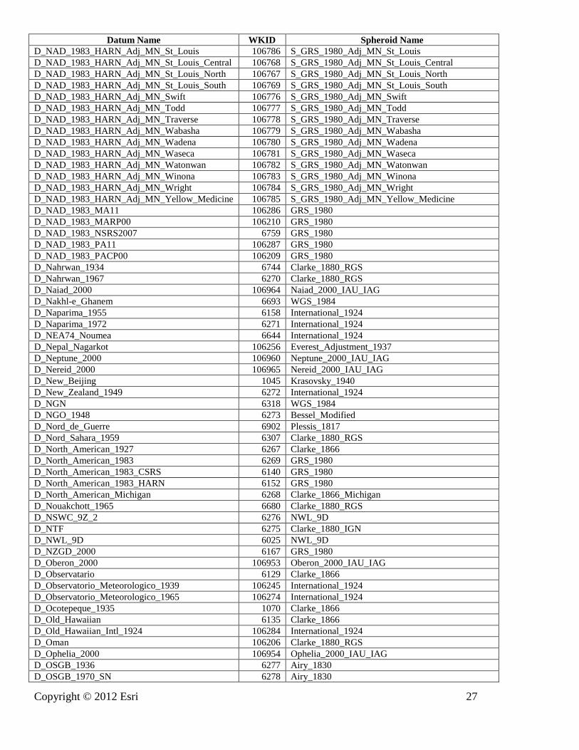
Copyright © 2012 Esri 27
Datum Name WKID Spheroid Name
D_NAD_1983_HARN_Adj_MN_St_Louis 106786 S_GRS_1980_Adj_MN_St_Louis
D_NAD_1983_HARN_Adj_MN_St_Louis_Central 106768 S_GRS_1980_Adj_MN_St_Louis_Central
D_NAD_1983_HARN_Adj_MN_St_Louis_North 106767 S_GRS_1980_Adj_MN_St_Louis_North
D_NAD_1983_HARN_Adj_MN_St_Louis_South 106769 S_GRS_1980_Adj_MN_St_Louis_South
D_NAD_1983_HARN_Adj_MN_Swift 106776 S_GRS_1980_Adj_MN_Swift
D_NAD_1983_HARN_Adj_MN_Todd 106777 S_GRS_1980_Adj_MN_Todd
D_NAD_1983_HARN_Adj_MN_Traverse 106778 S_GRS_1980_Adj_MN_Traverse
D_NAD_1983_HARN_Adj_MN_Wabasha 106779 S_GRS_1980_Adj_MN_Wabasha
D_NAD_1983_HARN_Adj_MN_Wadena 106780 S_GRS_1980_Adj_MN_Wadena
D_NAD_1983_HARN_Adj_MN_Waseca 106781 S_GRS_1980_Adj_MN_Waseca
D_NAD_1983_HARN_Adj_MN_Watonwan 106782 S_GRS_1980_Adj_MN_Watonwan
D_NAD_1983_HARN_Adj_MN_Winona 106783 S_GRS_1980_Adj_MN_Winona
D_NAD_1983_HARN_Adj_MN_Wright 106784 S_GRS_1980_Adj_MN_Wright
D_NAD_1983_HARN_Adj_MN_Yellow_Medicine 106785 S_GRS_1980_Adj_MN_Yellow_Medicine
D_NAD_1983_MA11 106286 GRS_1980
D_NAD_1983_MARP00 106210 GRS_1980
D_NAD_1983_NSRS2007 6759 GRS_1980
D_NAD_1983_PA11 106287 GRS_1980
D_NAD_1983_PACP00 106209 GRS_1980
D_Nahrwan_1934 6744 Clarke_1880_RGS
D_Nahrwan_1967 6270 Clarke_1880_RGS
D_Naiad_2000 106964 Naiad_2000_IAU_IAG
D_Nakhl-e_Ghanem 6693 WGS_1984
D_Naparima_1955 6158 International_1924
D_Naparima_1972 6271 International_1924
D_NEA74_Noumea 6644 International_1924
D_Nepal_Nagarkot 106256 Everest_Adjustment_1937
D_Neptune_2000 106960 Neptune_2000_IAU_IAG
D_Nereid_2000 106965 Nereid_2000_IAU_IAG
D_New_Beijing 1045 Krasovsky_1940
D_New_Zealand_1949 6272 International_1924
D_NGN 6318 WGS_1984
D_NGO_1948 6273 Bessel_Modified
D_Nord_de_Guerre 6902 Plessis_1817
D_Nord_Sahara_1959 6307 Clarke_1880_RGS
D_North_American_1927 6267 Clarke_1866
D_North_American_1983 6269 GRS_1980
D_North_American_1983_CSRS 6140 GRS_1980
D_North_American_1983_HARN 6152 GRS_1980
D_North_American_Michigan 6268 Clarke_1866_Michigan
D_Nouakchott_1965 6680 Clarke_1880_RGS
D_NSWC_9Z_2 6276 NWL_9D
D_NTF 6275 Clarke_1880_IGN
D_NWL_9D 6025 NWL_9D
D_NZGD_2000 6167 GRS_1980
D_Oberon_2000 106953 Oberon_2000_IAU_IAG
D_Observatario 6129 Clarke_1866
D_Observatorio_Meteorologico_1939 106245 International_1924
D_Observatorio_Meteorologico_1965 106274 International_1924
D_Ocotepeque_1935 1070 Clarke_1866
D_Old_Hawaiian 6135 Clarke_1866
D_Old_Hawaiian_Intl_1924 106284 International_1924
D_Oman 106206 Clarke_1880_RGS
D_Ophelia_2000 106954 Ophelia_2000_IAU_IAG
D_OSGB_1936 6277 Airy_1830
D_OSGB_1970_SN 6278 Airy_1830

28 Copyright © 2012 Esri
Datum Name WKID Spheroid Name
D_OSNI_1952 6188 Airy_1830
D_OS_SN_1980 6279 Airy_1830
D_OSU_86F 6032 OSU_86F
D_OSU_91A 6033 OSU_91A
D_Padang_1884 6280 Bessel_1841
D_Palestine_1923 6281 Clarke_1880_Benoit
D_Pampa_del_Castillo 6161 International_1924
D_Pan_2000 106936 Pan_2000_IAU_IAG
D_Panama-Colon-1911 1072 Clarke_1866
D_Pandora_2000 106937 Pandora_2000_IAU_IAG
D_Papua_New_Guinea_Geodetic_Datum_1994 1076 GRS_1980
D_Parametrop_Zemp_1990 6740 PZ_1990
D_Pasiphae_2000 106922 Pasiphae_2000_IAU_IAG
D_PDO_1993 6134 Clarke_1880_RGS
D_Peru96 1067 GRS_1980
D_Petrels_1972 6636 International_1924
D_Philippine_Reference_System_1992 6683 Clarke_1866
D_Phobos_2000 106907 Phobos_2000_IAU_IAG
D_Phoebe_2000 106938 Phoebe_2000_IAU_IAG
D_Pico_de_Las_Nieves 6728 International_1924
D_Pitcairn_1967 6729 International_1924
D_Pitcairn_2006 6763 WGS_1984
D_Plessis_1817 6027 Plessis_1817
D_Pluto_2000 106969 Pluto_2000_IAU_IAG
D_Pohnpei 106266 Clarke_1866
D_Point_58 6620 Clarke_1880_RGS
D_Pointe_Geologie_Perroud_1950 6637 International_1924
D_Pointe_Noire 6282 Clarke_1880_IGN
D_Portia_2000 106955 Portia_2000_IAU_IAG
D_Porto_Santo_1936 6615 International_1924
D_Porto_Santo_1995 6663 International_1924
D_POSGAR 6172 GRS_1980
D_POSGAR_1994 6694 GRS_1980
D_POSGAR_1998 6190 GRS_1980
D_POSGAR_2007 1062 GRS_1980
D_Potsdam_1983 6746 Bessel_1841
D_Principe 1046 International_1924
D_Prometheus_2000 106939 Prometheus_2000_IAU_IAG
D_Proteus_2000 106966 Proteus_2000_IAU_IAG
D_Provisional_S_American_1956 6248 International_1924
D_PTRA08 1041 GRS_1980
D_Puck_2000 106956 Puck_2000_IAU_IAG
D_Puerto_Rico 6139 Clarke_1866
D_Pulkovo_1942 6284 Krasovsky_1940
D_Pulkovo_1942_Adj_1958 6179 Krasovsky_1940
D_Pulkovo_1942_Adj_1983 6178 Krasovsky_1940
D_Pulkovo_1995 6200 Krasovsky_1940
D_Qatar 6285 International_1924
D_Qatar_1948 6286 Helmert_1906
D_QND_1995 6614 International_1924
D_Qornoq_1927 6194 International_1924
D_Rassadiran 6153 International_1924
D_Rauenberg_1983 6745 Bessel_1841
D_Red_Geodesica_de_Canarias_1995 1035 GRS_1980
D_REGVEN 6189 GRS_1980
D_Reseau_Geodesique_de_la_Polynesie_Francaise 6687 GRS_1980

Copyright © 2012 Esri 29
Datum Name WKID Spheroid Name
D_Reseau_Geodesique_de_la_RDC_2005 1033 GRS_1980
D_Reseau_Geodesique_de_Mayotte_2004 1036 GRS_1980
D_Reseau_Geodesique_de_Nouvelle_Caledonie_
1991-93
6749 GRS_1980
D_Reseau_Geodesique_de_St_Pierre_et_Miquelon
_2006
1038 GRS_1980
D_Reunion_1947 6626 International_1924
D_Reykjavik_1900 6657 Danish_1876
D_RGF_1993 6171 GRS_1980
D_RGFG_1995 6624 GRS_1980
D_RGNC_1991 6645 International_1924
D_RGR_1992 6627 GRS_1980
D_Rhea_2000 106940 Rhea_2000_IAU_IAG
D_Roma_1940 106275 International_1924
D_Rosalind_2000 106957 Rosalind_2000_IAU_IAG
D_Ross_Sea_Region_Geodetic_Datum_2000 6764 GRS_1980
D_RRAF_1991 1047 GRS_1980
D_RT_1990 6124 Bessel_1841
D_S42_Hungary 106257 Krasovsky_1940
D_Sainte_Anne 6622 International_1924
D_Saint_Pierre_et_Miquelon_1950 6638 Clarke_1866
D_Samboja 6125 Bessel_1841
D_Santo_DOS_1965 6730 International_1924
D_Sao_Braz 106249 International_1924
D_Sao_Tome 1044 International_1924
D_Sapper_Hill_1943 6292 International_1924
D_Saturn_2000 106925 Saturn_2000_IAU_IAG
D_Schwarzeck 6293 Bessel_Namibia
D_Scoresbysund_1952 6195 International_1924
D_Segora 6294 Bessel_1841
D_Selvagem_Grande_1938 6616 International_1924
D_Serbian_Reference_Network_1998 1034 GRS_1980
D_Serindung 6295 Bessel_1841
D_SGNP_MARCARIO_SOLIS 1066 GRS_1980
D_Sibun_Gorge_1922 1071 Clarke_1858
D_Sierra_Leone_1924 6174 War_Office
D_Sierra_Leone_1960 106103 Clarke_1880_RGS
D_Sierra_Leone_1968 6175 Clarke_1880_RGS
D_Sinope_2000 106923 Sinope_2000_IAU_IAG
D_SIRGAS 6170 GRS_1980
D_SIRGAS_2000 6674 GRS_1980
D_SIRGAS-Chile 1064 GRS_1980
D_SIRGAS_ES2007.8 1069 GRS_1980
D_SIRGAS-ROU98 1068 WGS_1984
D_S_JTSK 6156 Bessel_1841
D_S_JTSK_05 1052 Bessel_1841
D_S_JTSK_05_Ferro 1055 Bessel_1841
D_Slovenia_Geodetic_Datum_1996 6765 GRS_1980
D_Solomon_1968 6718 International_1924
D_South_American_1969 6618 GRS_1967_Truncated
D_South_American_Datum_1969_96 1075 GRS_1967_Truncated
D_South_Asia_Singapore 106207 Fischer_Modified
D_South_Yemen 6164 Krasovsky_1940
D_Sphere 6035 Sphere
D_Sphere_ARC_INFO 106008 Sphere_ARC_INFO
D_Sphere_Clarke_1866_Authalic 6052 Sphere_Clarke_1866_Authalic

30 Copyright © 2012 Esri
Datum Name WKID Spheroid Name
D_Sphere_EMEP 106276 Sphere_EMEP
D_Sphere_GRS_1980_Authalic 6047 Sphere_GRS_1980_Authalic
D_Sphere_International_1924_Authalic 6053 Sphere_International_1924_Authalic
D_Sri_Lanka_Datum_1999 1053 Everest_Adjustment_1937
D_ST71_Belep 6643 International_1924
D_ST84_Ile_des_Pins 6642 International_1924
D_ST87_Ouvea 6750 WGS_1984
D_St_George_Island 6138 Clarke_1866
D_St_Kitts_1955 6605 Clarke_1880_RGS
D_St_Lawrence_Island 6136 Clarke_1866
D_St_Lucia_1955 6606 Clarke_1880_RGS
D_Stockholm_1938 6308 Bessel_1841
D_St_Paul_Island 6137 Clarke_1866
D_Struve_1860 6028 Struve_1860
D_St_Vincent_1945 6607 Clarke_1880_RGS
D_Sudan 6296 Clarke_1880_IGN
D_SVY21 6757 WGS_1984
D_SWEREF99 6619 GRS_1980
D_Swiss_TRF_1995 6151 GRS_1980
D_Tahaa_1954 6629 International_1924
D_Tahiti_1952 6628 International_1924
D_Tahiti_1979 6690 International_1924
D_Tananarive_1925 6297 International_1924
D_Telesto_2000 106941 Telesto_2000_IAU_IAG
D_Tern_Island_1961 6707 International_1924
D_Tete 6127 Clarke_1866
D_Tethys_2000 106942 Tethys_2000_IAU_IAG
D_Thalassa_2000 106967 Thalassa_2000_IAU_IAG
D_Thebe_2000 106924 Thebe_2000_IAU_IAG
D_Timbalai_1948 6298 Everest_Definition_1967
D_Titan_2000 106943 Titan_2000_IAU_IAG
D_Titania_2000 106958 Titania_2000_IAU_IAG
D_TM65 6299 Airy_Modified
D_TM75 6300 Airy_Modified
D_Tokyo 6301 Bessel_1841
D_Trinidad_1903 6302 Clarke_1858
D_Tristan_1968 6734 International_1924
D_Triton_2000 106968 Triton_2000_IAU_IAG
D_Trucial_Coast_1948 6303 Helmert_1906
D_Turkish_National_Reference_Frame 1057 GRS_1980
D_TWD_1967 1025 GRS_1967_Truncated
D_TWD_1997 1026 GRS_1980
D_Ukraine_2000 1077 Krasovsky_1940
D_Umbriel_2000 106959 Umbriel_2000_IAU_IAG
D_Uranus_2000 106944 Uranus_2000_IAU_IAG
D_Vanua_Levu_1915 6748 Clarke_1880_Intl_Ft
D_Venus_1985 106901 Venus_1985_IAU_IAG_COSPAR
D_Venus_2000 106902 Venus_2000_IAU_IAG
D_Vientiane_1982 6676 Krasovsky_1940
D_Vietnam_2000 6756 WGS_1984
D_Viti_Levu_1912 6752 Clarke_1880_Intl_Ft
D_Viti_Levu_1916 6731 Clarke_1880_RGS
D_Voirol_1875 6304 Clarke_1880_IGN
D_Voirol_1879 6671 Clarke_1880_IGN
D_Voirol_Unifie_1960 6305 Clarke_1880_RGS
D_Wake_Eniwetok_1960 6732 Hough_1960

Copyright © 2012 Esri 31
Datum Name WKID Spheroid Name
D_Wake_Island_1952 6733 International_1924
D_Walbeck 106007 Walbeck
D_War_Office 6029 War_Office
D_WGS_1966 6760 WGS_1966
D_WGS_1972 6322 WGS_1972
D_WGS_1972_BE 6324 WGS_1972
D_WGS_1984 6326 WGS_1984
D_WGS_1984_Major_Auxiliary_Sphere 106283 WGS_1984_Major_Auxiliary_Sphere
D_Xian_1980 6610 Xian_1980
D_Yacare 6309 International_1924
D_Yemen_NGN_1996 6163 WGS_1984
D_Yoff 6310 Clarke_1880_IGN
D_Zanderij 6311 International_1924
Reseau_Geodesique_des_Antilles_Francaises_2009 1073 GRS_1980
Table 4: Angular units: well-known IDs and conversion values Angular Unit of Measure Name WKID Conversion Value:
Radians per Unit
Degree 9102 0.01745329251994
Gon 9106 0.01570796326795
Grad 9105 0.01570796326795
Microradian 9109 0.000001
Mil_6400 9114 0.00098174770425
Minute 9103 0.00029088820867
Minute_Centesimal 9112 0.00015707963268
Radian 9101 1.0
Second 9104 0.00000484813681
Second_Centesimal 9113 0.00000157079633
Table 5: Prime meridians: well -known IDs and longitude values Prime Meridian Name WKID Longitude Relative
to Greenwich in
degrees
Athens 8912 23.7163375
Bern 8907 7.43958333
Bogota 8904 -74.08091667
Brussels 8910 4.367975
Ferro 8909 -17.66666667
Greenwich 8901 0.0
Jakarta 8908 106.80771944
Lisbon 8902 -9.13190611
Madrid 8905 -3.68793889
Oslo 8913 10.72291667
Paris 8903 2.33722917
Paris_RGS 8914 2.33720833
Reference_Meridian 108900 0.0
Rome 8906 12.45233333
Stockholm 8911 18.05827778
Table 6: Spheroids: well-known IDs and defining parameters
Spheroid Name WKID Semimajor
Axis (m)
Semiminor
Axis (m)
Inverse
Flattening
Eccentricity
squared (e2)

32 Copyright © 2012 Esri
Spheroid Name WKID Semimajor
Axis (m)
Semiminor
Axis (m)
Inverse
Flattening
Eccentricity
squared (e2)
Adrastea_2000_IAU_IAG 107909 8200.000 8200.000 0.0 0.0
Airy_1830 7001 6377563.396 6356256.909 0.00334085 0.00667054
Airy_Modified 7002 6377340.189 6356034.448 0.00334085 0.00667054
Amalthea_2000_IAU_IAG 107910 83500.000 83500.000 0.0 0.0
Ananke_2000_IAU_IAG 107911 10000.000 10000.000 0.0 0.0
Ariel_2000_IAU_IAG 107945 578900.000 578900.000 0.0 0.0
Atlas_2000_IAU_IAG 107926 16000.000 16000.000 0.0 0.0
ATS_1977 7041 6378135.000 6356750.305 0.00335281 0.00669438
Australian 7003 6378160.000 6356774.719 0.00335289 0.00669454
Belinda_2000_IAU_IAG 107946 33000.000 33000.000 0.0 0.0
Bessel_1841 7004 6377397.155 6356078.963 0.00334277 0.00667437
Bessel_Modified 7005 6377492.018 6356173.509 0.00334277 0.00667437
Bessel_Namibia 7006 6377483.865 6356165.383 0.00334277 0.00667437
Bianca_2000_IAU_IAG 107947 21000.000 21000.000 0.0 0.0
Callisto_2000_IAU_IAG 107912 2409300.000 2409300.000 0.0 0.0
Calypso_2000_IAU_IAG 107927 9500.000 9500.000 0.0 0.0
Carme_2000_IAU_IAG 107913 15000.000 15000.000 0.0 0.0
CGCS2000 107038 6378137.000 6356752.314 0.00335281 0.00669438
Charon_2000_IAU_IAG 107970 593000.000 593000.000 0.0 0.0
Clarke_1858 7007 6378293.645 6356617.988 0.00339835 0.00678515
Clarke_1866 7008 6378206.400 6356583.800 0.00339008 0.00676866
Clarke_1866_Michigan 7009 6378450.047 6356826.620 0.00339008 0.00676866
Clarke_1880 7034 6378249.138 6356514.959 0.00340755 0.00680348
Clarke_1880_Arc 7013 6378249.145 6356514.966 0.00340755 0.00680348
Clarke_1880_Benoit 7010 6378300.790 6356566.430 0.00340755 0.00680348
Clarke_1880_IGN 7011 6378249.200 6356515.000 0.00340755 0.00680349
Clarke_1880_Intl_Ft 7055 6378306.370 6356571.996 0.00340755 0.00680348
Clarke_1880_RGS 7012 6378249.145 6356514.870 0.00340756 0.00680351
Clarke_1880_SGA 7014 6378249.200 6356514.997 0.00340755 0.00680349
Cordelia_2000_IAU_IAG 107948 13000.000 13000.000 0.0 0.0
Cressida_2000_IAU_IAG 107949 31000.000 31000.000 0.0 0.0
Danish_1876 7051 6377019.270 6355762.539 0.00333333 0.00665556
Deimos_2000_IAU_IAG 107906 6200.000 6200.000 0.0 0.0
Desdemona_2000_IAU_IAG 107950 27000.000 27000.000 0.0 0.0
Despina_2000_IAU_IAG 107961 74000.000 74000.000 0.0 0.0
Dione_2000_IAU_IAG 107928 560000.000 560000.000 0.0 0.0
Elara_2000_IAU_IAG 107914 40000.000 40000.000 0.0 0.0
Enceladus_2000_IAU_IAG 107929 249400.000 249400.000 0.0 0.0
Epimetheus_2000_IAU_IAG 107930 59500.000 59500.000 0.0 0.0
Europa_2000_IAU_IAG 107915 1562090.000 1562090.000 0.0 0.0
Everest_1830 7042 6377299.360 6356098.352 0.00332445 0.00663785
Everest_1830_Modified 7018 6377304.063 6356103.039 0.00332445 0.00663785
Everest_Adjustment_1937 7015 6377276.345 6356075.413 0.00332445 0.00663785
Everest_Definition_1962 7044 6377301.243 6356100.230 0.00332445 0.00663785
Everest_Definition_1967 7016 6377298.556 6356097.550 0.00332445 0.00663785
Everest_Definition_1975 7045 6377299.151 6356098.145 0.00332445 0.00663785
Everest_Modified_1969 7056 6377295.664 6356094.668 0.00332445 0.00663785
Fischer_1960 107002 6378166.000 6356784.284 0.00335233 0.00669342
Fischer_1968 107003 6378150.000 6356768.337 0.00335233 0.00669342
Fischer_Modified 107004 6378155.000 6356773.320 0.00335233 0.00669342
Galatea_2000_IAU_IAG 107962 79000.000 79000.000 0.0 0.0
Ganymede_2000_IAU_IAG 107916 2632345.000 2632345.000 0.0 0.0
GEM_10C 7031 6378137.000 6356752.314 0.00335281 0.00669438
GRS_1967 7036 6378160.000 6356774.516 0.00335292 0.00669461
GRS_1967_Truncated 7050 6378160.000 6356774.719 0.00335289 0.00669454

Copyright © 2012 Esri 33
Spheroid Name WKID Semimajor
Axis (m)
Semiminor
Axis (m)
Inverse
Flattening
Eccentricity
squared (e2)
GRS_1980 7019 6378137.000 6356752.314 0.00335281 0.00669438
Helene_2000_IAU_IAG 107931 16000.000 16000.000 0.0 0.0
Helmert_1906 7020 6378200.000 6356818.170 0.00335233 0.00669342
Himalia_2000_IAU_IAG 107917 85000.000 85000.000 0.0 0.0
Hough_1960 7053 6378270.000 6356794.343 0.00336700 0.00672267
Hughes_1980 7058 6378273.000 6356889.449 0.00335256 0.00669388
Hyperion_2000_IAU_IAG 107932 133000.000 133000.000 0.0 0.0
Iapetus_2000_IAU_IAG 107933 718000.000 718000.000 0.0 0.0
Indonesian 7021 6378160.000 6356774.504 0.00335293 0.00669461
International_1924 7022 6378388.000 6356911.946 0.00336700 0.00672267
International_1967 7023 6378160.000 6356774.719 0.00335289 0.00669454
Io_2000_IAU_IAG 107918 1821460.000 1821460.000 0.0 0.0
Janus_2000_IAU_IAG 107934 888000.000 888000.000 0.0 0.0
Juliet_2000_IAU_IAG 107951 42000.000 42000.000 0.0 0.0
Jupiter_2000_IAU_IAG 107908 71492000.000 66854000.000 0.06487439 0.12554010
Krasovsky_1940 7024 6378245.000 6356863.019 0.00335233 0.00669342
Larissa_2000_IAU_IAG 107963 104000.000 89000.000 0.14423077 0.26765902
Leda_2000_IAU_IAG 107919 5000.000 5000.000 0.0 0.0
Lysithea_2000_IAU_IAG 107920 12000.000 12000.000 0.0 0.0
Mars_1979_IAU_IAG 107904 3393400.000 3375730.000 0.00520717 0.01038722
Mars_2000_IAU_IAG 107905 3396190.000 3376200.000 0.00588601 0.01173737
Mercury_2000_IAU_IAG 107900 2439700.000 2439700.000 0.0 0.0
Metis_2000_IAU_IAG 107921 30000.000 20000.000 0.33333333 0.55555556
Mimas_2000_IAU_IAG 107935 1986300.000 1986300.000 0.0 0.0
Miranda_2000_IAU_IAG 107952 235800.000 235800.000 0.0 0.0
Moon_2000_IAU_IAG 107903 1737400.000 1737400.000 0.0 0.0
Naiad_2000_IAU_IAG 107964 29000.000 29000.000 0.0 0.0
Neptune_2000_IAU_IAG 107960 24764000.000 24341000.000 0.01708125 0.03387072
Nereid_2000_IAU_IAG 107965 170000.000 170000.000 0.0 0.0
NWL_10D 7026 6378135.000 6356750.520 0.00335278 0.00669432
NWL_9D 7025 6378145.000 6356759.769 0.00335289 0.00669454
Oberon_2000_IAU_IAG 107953 761400.000 761400.000 0.0 0.0
Ophelia_2000_IAU_IAG 107954 15000.000 15000.000 0.0 0.0
OSU_86F 7032 6378136.200 6356751.517 0.00335281 0.00669438
OSU_91A 7033 6378136.300 6356751.617 0.00335281 0.00669438
Pan_2000_IAU_IAG 107936 10000.000 10000.000 0.0 0.0
Pandora_2000_IAU_IAG 107937 41900.000 41900.000 0.0 0.0
Pasiphae_2000_IAU_IAG 107922 18000.000 18000.000 0.0 0.0
Phobos_2000_IAU_IAG 107907 11100.000 11100.000 0.0 0.0
Phoebe_2000_IAU_IAG 107938 110000.000 110000.000 0.0 0.0
Plessis_1817 7027 6376523.000 6355862.933 0.00324002 0.00646954
Pluto_2000_IAU_IAG 107969 1195000.000 1195000.000 0.0 0.0
Portia_2000_IAU_IAG 107955 54000.000 54000.000 0.0 0.0
Prometheus_2000_IAU_IAG 107939 50100.000 50100.000 0.0 0.0
Proteus_2000_IAU_IAG 107966 208000.000 208000.000 0.0 0.0
Puck_2000_IAU_IAG 107956 77000.000 77000.000 0.0 0.0
PZ_1990 7054 6378136.000 6356751.362 0.00335280 0.00669437
Rhea_2000_IAU_IAG 107940 764000.000 764000.000 0.0 0.0
Rosalind_2000_IAU_IAG 107957 27000.000 27000.000 0.0 0.0
Saturn_2000_IAU_IAG 107925 60268000.000 54364000.000 0.09796243 0.18632823
S_GRS_1980_Adj_MN_Anoka 107700 6378418.941 6357033.310 0.00335281 0.00669438
S_GRS_1980_Adj_MN_Becker 107701 6378586.581 6357200.388 0.00335281 0.00669438
S_GRS_1980_Adj_MN_Beltrami_North 107702 6378505.809 6357119.887 0.00335281 0.00669438
S_GRS_1980_Adj_MN_Beltrami_South 107703 6378544.823 6357158.770 0.00335281 0.00669438
S_GRS_1980_Adj_MN_Benton 107704 6378490.569 6357104.698 0.00335281 0.00669438

34 Copyright © 2012 Esri
Spheroid Name WKID Semimajor
Axis (m)
Semiminor
Axis (m)
Inverse
Flattening
Eccentricity
squared (e2)
S_GRS_1980_Adj_MN_Big_Stone 107705 6378470.757 6357084.952 0.00335281 0.00669438
S_GRS_1980_Adj_MN_Blue_Earth 107706 6378403.701 6357018.121 0.00335281 0.00669438
S_GRS_1980_Adj_MN_Brown 107707 6378434.181 6357048.499 0.00335281 0.00669438
S_GRS_1980_Adj_MN_Carlton 107708 6378454.907 6357069.155 0.00335281 0.00669438
S_GRS_1980_Adj_MN_Carver 107709 6378400.653 6357015.083 0.00335281 0.00669438
S_GRS_1980_Adj_MN_Cass_North 107710 6378567.378 6357181.249 0.00335281 0.00669438
S_GRS_1980_Adj_MN_Cass_South 107711 6378546.957 6357160.897 0.00335281 0.00669438
S_GRS_1980_Adj_MN_Chippewa 107712 6378476.853 6357091.028 0.00335281 0.00669438
S_GRS_1980_Adj_MN_Chisago 107713 6378411.321 6357025.715 0.00335281 0.00669438
S_GRS_1980_Adj_MN_Cook_North 107714 6378647.541 6357261.143 0.00335281 0.00669438
S_GRS_1980_Adj_MN_Cook_South 107715 6378647.541 6357261.143 0.00335281 0.00669438
S_GRS_1980_Adj_MN_Cottonwood 107716 6378514.953 6357129.000 0.00335281 0.00669438
S_GRS_1980_Adj_MN_Crow_Wing 107717 6378546.957 6357160.897 0.00335281 0.00669438
S_GRS_1980_Adj_MN_Dakota 107718 6378421.989 6357036.348 0.00335281 0.00669438
S_GRS_1980_Adj_MN_Dodge 107719 6378481.425 6357095.584 0.00335281 0.00669438
S_GRS_1980_Adj_MN_Douglas 107720 6378518.001 6357132.038 0.00335281 0.00669438
S_GRS_1980_Adj_MN_Faribault 107721 6378521.049 6357135.075 0.00335281 0.00669438
S_GRS_1980_Adj_MN_Fillmore 107722 6378464.661 6357078.877 0.00335281 0.00669438
S_GRS_1980_Adj_MN_Freeborn 107723 6378521.049 6357135.075 0.00335281 0.00669438
S_GRS_1980_Adj_MN_Goodhue 107724 6378434.181 6357048.499 0.00335281 0.00669438
S_GRS_1980_Adj_MN_Grant 107725 6378518.001 6357132.038 0.00335281 0.00669438
S_GRS_1980_Adj_MN_Hennepin 107726 6378418.941 6357033.310 0.00335281 0.00669438
S_GRS_1980_Adj_MN_Houston 107727 6378436.619 6357050.929 0.00335281 0.00669438
S_GRS_1980_Adj_MN_Isanti 107728 6378411.321 6357025.715 0.00335281 0.00669438
S_GRS_1980_Adj_MN_Itasca_North 107729 6378574.389 6357188.237 0.00335281 0.00669438
S_GRS_1980_Adj_MN_Itasca_South 107730 6378574.389 6357188.237 0.00335281 0.00669438
S_GRS_1980_Adj_MN_Jackson 107731 6378521.049 6357135.075 0.00335281 0.00669438
S_GRS_1980_Adj_MN_Kanabec 107732 6378472.281 6357086.471 0.00335281 0.00669438
S_GRS_1980_Adj_MN_Kandiyohi 107733 6378498.189 6357112.292 0.00335281 0.00669438
S_GRS_1980_Adj_MN_Kittson 107734 6378449.421 6357063.688 0.00335281 0.00669438
S_GRS_1980_Adj_MN_Koochiching 107735 6378525.621 6357139.632 0.00335281 0.00669438
S_GRS_1980_Adj_MN_Lac_Qui_Parle 107736 6378476.853 6357091.028 0.00335281 0.00669438
S_GRS_1980_Adj_MN_Lake_of_the_Woods_North 107737 6378466.185 6357080.395 0.00335281 0.00669438
S_GRS_1980_Adj_MN_Lake_of_the_Woods_South 107738 6378496.665 6357110.773 0.00335281 0.00669438
S_GRS_1980_Adj_MN_Le_Sueur 107739 6378434.181 6357048.499 0.00335281 0.00669438
S_GRS_1980_Adj_MN_Lincoln 107740 6378643.579 6357257.195 0.00335281 0.00669438
S_GRS_1980_Adj_MN_Lyon 107741 6378559.758 6357173.655 0.00335281 0.00669438
S_GRS_1980_Adj_MN_Mahnomen 107743 6378586.581 6357200.388 0.00335281 0.00669438
S_GRS_1980_Adj_MN_Marshall 107744 6378441.801 6357056.093 0.00335281 0.00669438
S_GRS_1980_Adj_MN_Martin 107745 6378521.049 6357135.075 0.00335281 0.00669438
S_GRS_1980_Adj_MN_McLeod 107742 6378414.369 6357028.753 0.00335281 0.00669438
S_GRS_1980_Adj_MN_Meeker 107746 6378498.189 6357112.292 0.00335281 0.00669438
S_GRS_1980_Adj_MN_Morrison 107747 6378502.761 6357116.849 0.00335281 0.00669438
S_GRS_1980_Adj_MN_Mower 107748 6378521.049 6357135.075 0.00335281 0.00669438
S_GRS_1980_Adj_MN_Murray 107749 6378617.061 6357230.766 0.00335281 0.00669438
S_GRS_1980_Adj_MN_Nicollet 107750 6378403.701 6357018.121 0.00335281 0.00669438
S_GRS_1980_Adj_MN_Nobles 107751 6378624.681 6357238.360 0.00335281 0.00669438
S_GRS_1980_Adj_MN_Norman 107752 6378468.623 6357082.825 0.00335281 0.00669438
S_GRS_1980_Adj_MN_Olmsted 107753 6378481.425 6357095.584 0.00335281 0.00669438
S_GRS_1980_Adj_MN_Ottertail 107754 6378525.621 6357139.632 0.00335281 0.00669438
S_GRS_1980_Adj_MN_Pennington 107755 6378445.763 6357060.042 0.00335281 0.00669438
S_GRS_1980_Adj_MN_Pine 107756 6378472.281 6357086.471 0.00335281 0.00669438
S_GRS_1980_Adj_MN_Pipestone 107757 6378670.401 6357283.927 0.00335281 0.00669438
S_GRS_1980_Adj_MN_Polk 107758 6378445.763 6357060.042 0.00335281 0.00669438
S_GRS_1980_Adj_MN_Pope 107759 6378502.761 6357116.849 0.00335281 0.00669438

Copyright © 2012 Esri 35
Spheroid Name WKID Semimajor
Axis (m)
Semiminor
Axis (m)
Inverse
Flattening
Eccentricity
squared (e2)
S_GRS_1980_Adj_MN_Ramsey 107760 6378418.941 6357033.310 0.00335281 0.00669438
S_GRS_1980_Adj_MN_Red_Lake 107761 6378445.763 6357060.042 0.00335281 0.00669438
S_GRS_1980_Adj_MN_Redwood 107762 6378438.753 6357053.055 0.00335281 0.00669438
S_GRS_1980_Adj_MN_Renville 107763 6378414.369 6357028.753 0.00335281 0.00669438
S_GRS_1980_Adj_MN_Rice 107764 6378434.181 6357048.499 0.00335281 0.00669438
S_GRS_1980_Adj_MN_Rock 107765 6378624.681 6357238.360 0.00335281 0.00669438
S_GRS_1980_Adj_MN_Roseau 107766 6378449.421 6357063.688 0.00335281 0.00669438
S_GRS_1980_Adj_MN_Scott 107770 6378421.989 6357036.348 0.00335281 0.00669438
S_GRS_1980_Adj_MN_Sherburne 107771 6378443.325 6357057.612 0.00335281 0.00669438
S_GRS_1980_Adj_MN_Sibley 107772 6378414.369 6357028.753 0.00335281 0.00669438
S_GRS_1980_Adj_MN_Stearns 107773 6378502.761 6357116.849 0.00335281 0.00669438
S_GRS_1980_Adj_MN_Steele 107774 6378481.425 6357095.584 0.00335281 0.00669438
S_GRS_1980_Adj_MN_Stevens 107775 6378502.761 6357116.849 0.00335281 0.00669438
S_GRS_1980_Adj_MN_St_Louis 107786 6378523.000 6357138.314 0.00335261 0.00669398
S_GRS_1980_Adj_MN_St_Louis_Central 107768 6378605.783 6357219.525 0.00335281 0.00669438
S_GRS_1980_Adj_MN_St_Louis_North 107767 6378543.909 6357157.859 0.00335281 0.00669438
S_GRS_1980_Adj_MN_St_Louis_South 107769 6378540.861 6357154.821 0.00335281 0.00669438
S_GRS_1980_Adj_MN_Swift 107776 6378470.757 6357084.952 0.00335281 0.00669438
S_GRS_1980_Adj_MN_Todd 107777 6378548.481 6357162.416 0.00335281 0.00669438
S_GRS_1980_Adj_MN_Traverse 107778 6378463.746 6357077.965 0.00335281 0.00669438
S_GRS_1980_Adj_MN_Wabasha 107779 6378426.561 6357040.904 0.00335281 0.00669438
S_GRS_1980_Adj_MN_Wadena 107780 6378546.957 6357160.897 0.00335281 0.00669438
S_GRS_1980_Adj_MN_Waseca 107781 6378481.425 6357095.584 0.00335281 0.00669438
S_GRS_1980_Adj_MN_Watonwan 107782 6378514.953 6357129.000 0.00335281 0.00669438
S_GRS_1980_Adj_MN_Winona 107783 6378453.688 6357067.940 0.00335281 0.00669438
S_GRS_1980_Adj_MN_Wright 107784 6378443.325 6357057.612 0.00335281 0.00669438
S_GRS_1980_Adj_MN_Yellow_Medicine 107785 6378530.193 6357144.189 0.00335281 0.00669438
Sinope_2000_IAU_IAG 107923 14000.000 14000.000 0.0 0.0
Sphere 7035 6371000.000 6371000.000 0.0 0.0
Sphere_ARC_INFO 107008 6370997.000 6370997.000 0.0 0.0
Sphere_Clarke_1866_Authalic 7052 6370997.000 6370997.000 0.0 0.0
Sphere_EMEP 107009 6370000.000 6370000.000 0.0 0.0
Sphere_GRS_1980_Authalic 7048 6371007.000 6371007.000 0.0 0.0
Sphere_International_1924_Authalic 7057 6371228.000 6371228.000 0.0 0.0
Struve_1860 7028 6378298.300 6356657.143 0.00339294 0.00677436
Telesto_2000_IAU_IAG 107941 11000.000 11000.000 0.0 0.0
Tethys_2000_IAU_IAG 107942 529800.000 529800.000 0.0 0.0
Thalassa_2000_IAU_IAG 107967 40000.000 40000.000 0.0 0.0
Thebe_2000_IAU_IAG 107924 49300.000 49300.000 0.0 0.0
Titan_2000_IAU_IAG 107943 2575000.000 2575000.000 0.0 0.0
Titania_2000_IAU_IAG 107958 788900.000 788900.000 0.0 0.0
Triton_2000_IAU_IAG 107968 1352600.000 1352600.000 0.0 0.0
Umbriel_2000_IAU_IAG 107959 584700.000 584700.000 0.0 0.0
Uranus_2000_IAU_IAG 107944 25559000.000 24973000.000 0.02292734 0.04532903
Venus_1985_IAU_IAG_COSPAR 107901 6051000.000 6051000.000 0.0 0.0
Venus_2000_IAU_IAG 107902 6051800.000 6051800.000 0.0 0.0
Walbeck 107007 6376896.000 6355834.847 0.00330273 0.00659455
War_Office 7029 6378300.000 6356751.689 0.00337838 0.00674534
WGS_1966 107001 6378145.000 6356759.769 0.00335289 0.00669454
WGS_1972 7043 6378135.000 6356750.520 0.00335278 0.00669432
WGS_1984 7030 6378137.000 6356752.314 0.00335281 0.00669438
WGS_1984_Major_Auxiliary_Sphere 107037 6378137.000 6378137.000 0.0 0.0
Xian_1980 7049 6378140.000 6356755.288 0.00335281 0.00669438

36 Copyright © 2012 Esri
Table 7: Vertical coordinate systems: well -known IDs and areas of use
VCS Name WKID Area of Use Minimum
Latitude
Minimum
Longitude
Maximum
Latitude
Maximum
Longitude
AHD 5711 Australia - mainland -39.150 112.910 -10.140 153.620
AHD_Tasmania 5712 Australia - Tasmania mainland
onshore
-43.500 144.500 -40.300 149.000
AIOC95_Depth 5734 Azerbaijan - offshore and Sangachal 37.900 48.660 42.580 51.730
AIOC95_Height 5797 Azerbaijan - offshore and Sangachal 37.900 48.660 42.580 51.730
Alicante 5782 Spain - mainland onshore 35.960 -9.360 43.810 3.390
Antalya 5775 Turkey - onshore 35.820 25.620 42.140 44.820
Auckland 5759 New Zealand - North Island -
Auckland vcrs
-37.500 174.000 -35.800 176.000
Baltic 5705 Europe - FSU, Czechoslovakia -
onshore
35.150 12.090 81.900 -169.570
Baltic_1982 5786 Bulgaria - onshore 41.240 22.370 44.220 28.670
Baltic_depth 5612 Europe - FSU, Czechoslovakia -
onshore
35.150 12.090 81.900 -169.570
Bandar_Abbas 5752 Iran - onshore 24.950 44.060 39.800 63.370
Belfast 5732 UK - Northern Ireland - onshore 53.960 -8.170 55.350 -5.350
Black_Sea 5735 Georgia - onshore 41.050 40.000 43.580 46.710
Bluff 5760 New Zealand - South Island - Bluff
vcrs
-46.600 168.000 -46.300 168.700
Bora_Bora_SAU_2001 5607 French Polynesia - Society Islands -
Bora Bora
-16.650 -152.330 -16.420 -151.650
Cascais 5780 Portugal - mainland - onshore 36.960 -9.550 42.150 -6.190
Caspian 5706 Asia - FSU - Caspian Sea 37.350 46.950 46.960 53.920
Caspian_height 5611 Asia - FSU - Caspian Sea 37.350 46.950 46.960 53.920
CGVD_1928 5713 Canada - CVD28 41.680 -141.000 69.800 -59.740
Chatham_Island 5771 New Zealand - Chatham Island
onshore
-45.000 -178.000 -43.000 -175.000
Constanta 5781 Romania - onshore 43.620 20.260 48.260 29.730
Danger_1950 5792 St Pierre and Miquelon - onshore 46.700 -56.470 47.180 -56.070
Dansk_Normal_Nul 5733 Denmark - onshore 54.510 8.000 57.800 15.240
DHHN85 5784 Germany - West Germany all states 47.270 5.870 55.090 13.830
DHHN92 5783 Germany - onshore 47.270 5.870 55.090 15.030
Douglas 5750 Isle of Man - onshore 54.010 -4.830 54.480 -4.250
Dunedin 5761 New Zealand - South Island -
Dunedin vcrs
-46.000 168.000 -44.000 171.000
Dunedin_Bluff_1960_height 4458 New Zealand - South Island -
Dunedin-Bluff vcrs
-46.700 166.400 -44.700 170.300
Durres 5777 Albania - onshore 39.640 19.220 42.660 21.050
DVR90 5799 Denmark - onshore 54.510 8.000 57.800 15.240
EGM2008_Geoid 3855 World -90.000 -180.000 90.000 180.000
EGM84_Geoid 5798 World -90.000 -180.000 90.000 180.000
EGM96_Geoid 5773 World -90.000 -180.000 90.000 180.000
EOMA_1980 5787 Hungary 45.750 16.110 48.580 22.890
ETRS_1989 115701 Europe - ETRS89 32.880 -16.100 84.160 39.640
EVRF_2007 5621 Europe - EVRF2007 35.260 -9.550 71.200 31.580
EVRS_2000 5730 Europe - EVRF2000 35.260 -9.550 71.200 31.580
Fahud_Height_Datum_1993 5725 Oman - onshore 16.600 51.900 26.400 59.890
Fair_Isle 5741 UK - Fair Isle onshore 59.450 -1.760 59.600 -1.510
Fao 5751 Asia - Middle East -SE Iraq and SW
Iran
29.000 44.300 33.500 50.830
Fao_1979 3886 Iraq - onshore 29.060 38.820 37.410 49.400
Flannan_Isles 5748 UK - Flannan Isles onshore 58.220 -7.750 58.350 -7.460
Foula 5743 UK - Foula onshore 60.070 -2.200 60.190 -1.950

Copyright © 2012 Esri 37
VCS Name WKID Area of Use Minimum
Latitude
Minimum
Longitude
Maximum
Latitude
Maximum
Longitude
FVR09_height 5317 Faroe Islands - onshore 61.340 -7.480 62.410 -6.340
Genoa_height 5214 Italy - mainland and Sicily 36.600 6.620 47.090 18.580
GHA 5778 Austria 46.410 9.530 49.020 17.170
Gisborne 5762 New Zealand - North Island -
Gisborne vcrs
-39.000 176.300 -37.500 178.500
Guadeloupe_1951 5795 Guadeloupe - Grande-Terre and
Basse-Terre - onshore
15.880 -61.850 16.540 -61.160
Ha_Tien_1960 5726 Asia - Cambodia and Vietnam -
onshore
8.560 102.140 23.320 109.460
Hon_Dau_1992 5727 Vietnam - onshore 8.450 103.800 23.390 109.600
Hong_Kong_Chart_Datum 5739 China - Hong Kong - offshore 22.160 113.890 22.620 114.570
Hong_Kong_Principal_Datum 5738 China - Hong Kong - onshore 22.160 113.890 22.620 114.570
Huahine_SAU_2001 5605 French Polynesia - Society Islands -
Huahine
-16.850 -151.060 -16.670 -150.930
HVRS_1971 5610 Croatia - onshore 42.350 13.430 46.540 19.430
IGLD_1955 5608 North America - Great Lakes basin
and St Lawrence Seaway
41.000 -93.160 52.210 -54.760
IGLD_1985 5609 North America - Great Lakes basin
and St Lawrence Seaway
41.000 -93.160 52.210 -54.760
IGN_1966 5601 French Polynesia - Society Islands -
Tahiti
-17.910 -149.690 -17.450 -149.070
IGN_1987 5756 Martinique - onshore 14.350 -61.280 14.930 -60.770
IGN_1988 5757 Guadeloupe - Grande-Terre and
Basse-Terre - onshore
15.880 -61.850 16.540 -61.160
IGN_1988_LS 5616 Guadeloupe - Les Saintes - onshore 15.800 -61.680 15.930 -61.520
IGN_1988_MG 5617 Guadeloupe - Marie-Galante -
onshore
15.800 -61.380 16.040 -61.140
IGN_1988_SB 5619 Guadeloupe - St Barthelemy -
onshore
17.830 -62.920 17.980 -62.730
IGN_1988_SM 5620 Guadeloupe - St Martin - onshore 18.020 -63.200 18.170 -62.960
IGN_1989 5758 Reunion - onshore -21.400 55.200 -20.800 55.800
IGN_1992_LD 5618 Guadeloupe - La Desirade - onshore 16.270 -61.130 16.370 -60.970
Incheon_height 5193 Korea, Republic of (South Korea) -
mainland
33.900 125.100 38.640 129.600
Japanese_Standard_Levelling_
Datum_1949
5723 Japan - Hokkaido, Honshu,
Shikoku, Kyushu - onshore
30.150 128.500 45.920 146.090
KOC_Construction_Datum 5790 Kuwait - onshore 28.560 46.570 30.100 48.450
KOC_WD_depth_ft 5614 Kuwait - onshore 28.560 46.570 30.100 48.450
KOC_Well_Datum 5789 Kuwait - onshore 28.560 46.570 30.100 48.450
Kuwait_PWD 5788 Kuwait - onshore 28.560 46.570 30.100 48.450
Lagos_1955 5796 Nigeria - onshore 4.150 2.700 13.900 14.680
Lerwick 5742 UK - Shetland Islands onshore 59.800 -1.790 60.890 -0.660
LHN95 5729 Europe - Liechtenstein and
Switzerland
45.830 5.970 47.810 10.490
LN_1902 5728 Europe - Liechtenstein and
Switzerland
45.830 5.970 47.810 10.490
Lyttleton 5763 New Zealand - South Island -
Lyttleton vcrs
-45.000 168.200 -41.300 174.000
Malin_Head 5731 Europe - Ireland (Republic and
Ulster) - onshore
51.400 -10.560 55.430 -5.350
Maputo 5722 Mozambique - onshore -26.880 30.230 -10.400 40.900
Martinique_1955 5794 Martinique - onshore 14.350 -61.280 14.930 -60.770
Maupiti_SAU_2001 5604 French Polynesia - Society Islands -
Maupiti
-16.520 -152.330 -16.330 -152.160
Mayotte_1950 5793 Mayotte - onshore -13.000 44.970 -12.600 45.320
Moorea_SAU_1981 5602 French Polynesia - Society Islands - -17.610 -149.960 -17.450 -149.690

38 Copyright © 2012 Esri
VCS Name WKID Area of Use Minimum
Latitude
Minimum
Longitude
Maximum
Latitude
Maximum
Longitude
Moorea
Moturiki 5764 New Zealand - North Island -
Moturiki vcrs
-40.200 174.200 -37.500 177.400
MSL_Depth 5715 World -90.000 -180.000 90.000 180.000
MSL_Height 5714 World -90.000 -180.000 90.000 180.000
N2000_height 3900 Finland - onshore 59.760 19.410 70.090 31.580
N60 5717 Finland - onshore 59.760 19.410 70.090 31.580
NAD_1983 115702 North America - NAD83 14.930 167.650 86.450 -47.740
NAP 5709 Netherlands - onshore 50.750 3.210 53.710 7.210
Napier 5765 New Zealand - North Island -
Hawkes Bay mc Napier vcrs
-40.600 175.900 -38.900 178.100
NAVD_1988 5703 USA - CONUS and east Alaska -
onshore
24.410 -152.000 70.620 -66.920
Nelson 5766 New Zealand - South Island -
Nelson vcrs
-42.300 171.500 -40.500 173.600
Newlyn 5701 UK - Great Britain mainland
onshore
49.910 -7.080 58.710 1.830
Newlyn_Orkney_Isles 5740 UK - Orkney Islands onshore 58.620 -3.530 59.450 -2.230
NGC_1948 5791 France - Corsica onshore 41.310 8.500 43.060 9.630
NGF_IGN69 5720 France - mainland onshore 42.330 -4.870 51.140 8.230
NGF_IGN78 5721 France - Corsica onshore 41.310 8.500 43.060 9.630
NGF_Lallemand 5719 France - mainland onshore 42.330 -4.870 51.140 8.230
NGG_1977 5755 French Guiana - onshore 2.110 -54.600 5.810 -51.620
NG_L 5774 Luxembourg 49.450 5.730 50.180 6.520
NGNC 5753 New Caledonia - Grande Terre -22.500 163.900 -20.000 167.100
NGPF 5600 French Polynesia - Society Islands -
main islands
-17.910 -152.330 -16.420 -149.070
NGVD_1929 5702 USA - CONUS - onshore 24.410 -124.790 49.380 -66.920
NN54 5776 Norway - onshore 57.940 4.690 71.200 31.220
North_Rona 5745 UK - North Rona onshore 59.070 -5.920 59.190 -5.730
NVN99 5779 Slovenia - onshore 45.430 13.380 46.880 16.610
NZVD2009_height 4440 New Zealand -55.950 157.410 -22.740 -170.890
One_Tree_Point 5767 New Zealand - North Island - One
Tree vcrs
-36.500 172.500 -34.000 175.000
Oostende 5710 Belgium - onshore 49.510 2.510 51.500 6.400
PDO_Height_Datum_1993 5724 Oman - onshore 16.600 51.900 26.400 59.890
Piraeus 5716 Greece - onshore 34.880 19.580 41.750 28.300
Poolbeg 5754 Europe - Ireland (Republic and
Ulster) - onshore
51.400 -10.560 55.430 -5.350
Raiatea_SAU_2001 5603 French Polynesia - Society Islands -
Raiatea
-16.940 -151.570 -16.690 -151.410
RH1900 5615 Sweden - onshore 55.290 10.940 69.060 24.170
RH2000 5613 Sweden - onshore 55.290 10.940 69.060 24.170
RH70 5718 Sweden - onshore 55.290 10.940 69.060 24.170
SLVD_height 5237 Sri Lanka - onshore 5.850 79.600 9.920 81.950
SNN76 5785 Germany - East Germany all states 50.200 9.920 54.730 15.030
Stewart_Island 5772 New Zealand - Stewart Island -47.400 167.300 -46.670 168.450
St_Kilda 5747 UK - St. Kilda onshore 57.750 -8.730 57.920 -8.410
St_Marys 5749 UK - Scilly Isles onshore 49.810 -6.490 50.040 -6.160
Stornoway 5746 UK - Outer Hebrides onshore 56.890 -7.650 58.560 -6.050
Sule_Skerry 5744 UK - Sule Skerry onshore 59.050 -4.490 59.130 -4.310
Tahaa_SAU_2001 5606 French Polynesia - Society Islands -
Tahaa
-16.690 -151.500 -16.550 -151.340
Taranaki 5769 New Zealand - North Island -
Taranaki vcrs
-40.000 173.700 -38.500 175.000
Tararu 5768 New Zealand - North Island - -37.200 175.400 -36.900 176.000

Copyright © 2012 Esri 39
VCS Name WKID Area of Use Minimum
Latitude
Minimum
Longitude
Maximum
Latitude
Maximum
Longitude
Tararu vcrs
Trieste_height 5195 Europe - former Yugoslavia
onshore
40.860 13.380 46.880 23.030
Wellington 5770 New Zealand - North Island -
Wellington vcrs
-41.800 176.300 -40.000 178.500
WGS_1984 115700 World -90.000 -180.000 90.000 180.000
WGS_1984_Geoid 105700 World -90.000 -180.000 90.000 180.000
Yellow_Sea_1956 5736 China - onshore 18.040 73.660 53.590 134.850
Yellow_Sea_1985 5737 China - onshore 18.040 73.660 53.590 134.850
Table 8: Vertical coordinate systems: gravity-related or ellipsoidal-based and directions VCS Name WKID Model Positive Direction
AHD 5711 Gravity-related Positive up
AHD_Tasmania 5712 Gravity-related Positive up
AIOC95_Depth 5734 Gravity-related Positive down
AIOC95_Height 5797 Gravity-related Positive up
Alicante 5782 Gravity-related Positive up
Antalya 5775 Gravity-related Positive up
Auckland 5759 Gravity-related Positive up
Baltic 5705 Gravity-related Positive up
Baltic_1982 5786 Gravity-related Positive up
Baltic_depth 5612 Gravity-related Positive down
Bandar_Abbas 5752 Gravity-related Positive up
Belfast 5732 Gravity-related Positive up
Black_Sea 5735 Gravity-related Positive up
Bluff 5760 Gravity-related Positive up
Bora_Bora_SAU_2001 5607 Gravity-related Positive up
Cascais 5780 Gravity-related Positive up
Caspian 5706 Gravity-related Positive down
Caspian_height 5611 Gravity-related Positive up
CGVD_1928 5713 Gravity-related Positive up
Chatham_Island 5771 Gravity-related Positive up
Constanta 5781 Gravity-related Positive up
Danger_1950 5792 Gravity-related Positive up
Dansk_Normal_Nul 5733 Gravity-related Positive up
DHHN85 5784 Gravity-related Positive up
DHHN92 5783 Gravity-related Positive up
Douglas 5750 Gravity-related Positive up
Dunedin 5761 Gravity-related Positive up
Dunedin_Bluff_1960_height 4458 Gravity-related Positive up
Durres 5777 Gravity-related Positive up
DVR90 5799 Gravity-related Positive up
EGM2008_Geoid 3855 Gravity-related Positive up
EGM84_Geoid 5798 Gravity-related Positive up
EGM96_Geoid 5773 Gravity-related Positive up
EOMA_1980 5787 Gravity-related Positive up
ETRS_1989 115701 Ellipsoidal Positive up
EVRF_2007 5621 Gravity-related Positive up
EVRS_2000 5730 Gravity-related Positive up
Fahud_Height_Datum_1993 5725 Gravity-related Positive up
Fair_Isle 5741 Gravity-related Positive up
Fao 5751 Gravity-related Positive up
Fao_1979 3886 Gravity-related Positive up
Flannan_Isles 5748 Gravity-related Positive up

40 Copyright © 2012 Esri
VCS Name WKID Model Positive Direction
Foula 5743 Gravity-related Positive up
FVR09_height 5317 Gravity-related Positive up
Genoa_height 5214 Gravity-related Positive up
GHA 5778 Gravity-related Positive up
Gisborne 5762 Gravity-related Positive up
Guadeloupe_1951 5795 Gravity-related Positive up
Ha_Tien_1960 5726 Gravity-related Positive up
Hon_Dau_1992 5727 Gravity-related Positive up
Hong_Kong_Chart_Datum 5739 Gravity-related Positive down
Hong_Kong_Principal_Datum 5738 Gravity-related Positive up
Huahine_SAU_2001 5605 Gravity-related Positive up
HVRS_1971 5610 Gravity-related Positive up
IGLD_1955 5608 Gravity-related Positive up
IGLD_1985 5609 Gravity-related Positive up
IGN_1966 5601 Gravity-related Positive up
IGN_1987 5756 Gravity-related Positive up
IGN_1988 5757 Gravity-related Positive up
IGN_1988_LS 5616 Gravity-related Positive up
IGN_1988_MG 5617 Gravity-related Positive up
IGN_1988_SB 5619 Gravity-related Positive up
IGN_1988_SM 5620 Gravity-related Positive up
IGN_1989 5758 Gravity-related Positive up
IGN_1992_LD 5618 Gravity-related Positive up
Incheon_height 5193 Gravity-related Positive up
Japanese_Standard_Levelling_Datum_1949 5723 Gravity-related Positive up
KOC_Construction_Datum 5790 Gravity-related Positive up
KOC_WD_depth_ft 5614 Gravity-related Positive down
KOC_Well_Datum 5789 Gravity-related Positive down
Kuwait_PWD 5788 Gravity-related Positive up
Lagos_1955 5796 Gravity-related Positive up
Lerwick 5742 Gravity-related Positive up
LHN95 5729 Gravity-related Positive up
LN_1902 5728 Gravity-related Positive up
Lyttleton 5763 Gravity-related Positive up
Malin_Head 5731 Gravity-related Positive up
Maputo 5722 Gravity-related Positive up
Martinique_1955 5794 Gravity-related Positive up
Maupiti_SAU_2001 5604 Gravity-related Positive up
Mayotte_1950 5793 Gravity-related Positive up
Moorea_SAU_1981 5602 Gravity-related Positive up
Moturiki 5764 Gravity-related Positive up
MSL_Depth 5715 Gravity-related Positive down
MSL_Height 5714 Gravity-related Positive up
N2000_height 3900 Gravity-related Positive up
N60 5717 Gravity-related Positive up
NAD_1983 115702 Ellipsoidal Positive up
NAP 5709 Gravity-related Positive up
Napier 5765 Gravity-related Positive up
NAVD_1988 5703 Gravity-related Positive up
Nelson 5766 Gravity-related Positive up
Newlyn 5701 Gravity-related Positive up
Newlyn_Orkney_Isles 5740 Gravity-related Positive up
NGC_1948 5791 Gravity-related Positive up
NGF_IGN69 5720 Gravity-related Positive up
NGF_IGN78 5721 Gravity-related Positive up
NGF_Lallemand 5719 Gravity-related Positive up

Copyright © 2012 Esri 41
VCS Name WKID Model Positive Direction
NGG_1977 5755 Gravity-related Positive up
NG_L 5774 Gravity-related Positive up
NGNC 5753 Gravity-related Positive up
NGPF 5600 Gravity-related Positive up
NGVD_1929 5702 Gravity-related Positive up
NN54 5776 Gravity-related Positive up
North_Rona 5745 Gravity-related Positive up
NVN99 5779 Gravity-related Positive up
NZVD2009_height 4440 Gravity-related Positive up
One_Tree_Point 5767 Gravity-related Positive up
Oostende 5710 Gravity-related Positive up
PDO_Height_Datum_1993 5724 Gravity-related Positive up
Piraeus 5716 Gravity-related Positive up
Poolbeg 5754 Gravity-related Positive up
Raiatea_SAU_2001 5603 Gravity-related Positive up
RH1900 5615 Gravity-related Positive up
RH2000 5613 Gravity-related Positive up
RH70 5718 Gravity-related Positive up
SLVD_height 5237 Gravity-related Positive up
SNN76 5785 Gravity-related Positive up
Stewart_Island 5772 Gravity-related Positive up
St_Kilda 5747 Gravity-related Positive up
St_Marys 5749 Gravity-related Positive up
Stornoway 5746 Gravity-related Positive up
Sule_Skerry 5744 Gravity-related Positive up
Tahaa_SAU_2001 5606 Gravity-related Positive up
Taranaki 5769 Gravity-related Positive up
Tararu 5768 Gravity-related Positive up
Trieste_height 5195 Gravity-related Positive up
Wellington 5770 Gravity-related Positive up
WGS_1984 115700 Ellipsoidal Positive up
WGS_1984_Geoid 105700 Gravity-related Positive up
Yellow_Sea_1956 5736 Gravity-related Positive up
Yellow_Sea_1985 5737 Gravity-related Positive up
Table 9: Vertical datums: well-known IDs Vertical Datum Name WKID
AIOC_1995 5133
Alicante 5180
Antalya 5173
Auckland 5157
Australian_Height_Datum 5111
Australian_Height_Datum_Tasmania 5112
Baltic_1980 5185
Baltic_1982 5184
Baltic_Sea 5105
Bandar_Abbas 5150
Belfast 5131
Black_Sea 5134
Bluff 5158
Bora_Bora_SAU_2001 5202
Canadian_Geodetic_Vertical_Datum_of_1928 5114
Cascais 5178

42 Copyright © 2012 Esri
Vertical Datum Name WKID
Caspian_Sea 5106
Chatham_Island 5169
Constanta 5179
Croatian_Vertical_Reference_System_1971 5207
Danger_1950 5190
Dansk_Normal_Nul 5132
Dansk_Vertical_Reference_1990 5206
Deutches_Haupthohennetz_1985 5182
Deutches_Haupthohennetz_1992 5181
Douglas 5148
Dunedin 5159
Dunedin_Bluff_1960 1040
Durres 5175
EGM2008_Geoid 1027
EGM84_Geoid 5203
EGM96_Geoid 5171
European_Vertical_Reference_Frame_2000 5129
European_Vertical_Reference_Frame_2007 5215
Fahud_Height_Datum 5124
Fair_Isle 5139
Fao 5149
Fao_1979 1028
Faroe_Islands_Vertical_Reference_2009 1059
Flannan_Isles 5146
Foula 5141
Gebrauchshohen_Adria 5176
Genoa 1051
Gisborne 5160
Guadeloupe_1951 5193
Ha_Tien_1960 5125
Helsinki_1960 5116
Hon_Dau_1992 5126
Hong_Kong_Chart_Datum 5136
Hong_Kong_Principal_Datum 5135
Huahine_SAU_2001 5200
IGN_1966 5196
IGN_1987 5154
IGN_1988 5155
IGN_1988_LS 5210
IGN_1988_MG 5211
IGN_1988_SB 5213
IGN_1988_SM 5214
IGN_1989 5156
IGN_1992_LD 5212
Incheon 1049
International_Great_Lakes_Datum_1955 5204
International_Great_Lakes_Datum_1985 5205
Japanese_Standard_Levelling_Datum_1949 5122
KOC_Construction_Datum 5188
KOC_Well_Datum 5187
Kuwait_PWD 5186
Lagos_1955 5194
Landeshohennetz_1995 5128
Landesnivellement_1902 5127
Lerwick 5140
Lyttleton 5161

Copyright © 2012 Esri 43
Vertical Datum Name WKID
Malin_Head 5130
Maputo 5121
Martinique_1955 5192
Maupiti_SAU_2001 5199
Mayotte_1950 5191
Mean_Sea_Level 5100
Moorea_SAU_1981 5197
Moturiki 5162
N2000 1030
Napier 5163
National_Geodetic_Vertical_Datum_1929 5102
National_Vertical_Network_1999 5177
Nelson 5164
New_Zealand_Vertical_Datum_2009 1039
Nivellement_General_de_la_Corse_1948 5189
Nivellement_General_de_la_France_IGN69 5119
Nivellement_General_de_la_France_IGN78 5120
Nivellement_General_de_la_France_Lallemand 5118
Nivellement_General_de_Nouvelle_Caledonie 5151
Nivellement_General_de_Polynesie_Francaise 5195
Nivellement_General_du_Luxembourg 5172
Nivellement_General_Guyanais_1977 5153
Normaal_Amsterdams_Peil 5109
North_American_Vertical_Datum_1988 5103
North_Rona 5143
Norway_Normal_Nul_1954 5174
One_Tree_Point 5165
Oostende 5110
Ordnance_Datum_Newlyn 5101
Ordnance_Datum_Newlyn_Orkney_Isles 5138
PDO_Height_Datum_1993 5123
Piraeus_Harbour_1986 5115
Poolbeg 5152
Raiatea_SAU_2001 5198
Rikets_Hojdsystem_1900 5209
Rikets_Hojdsystem_1970 5117
Rikets_Hojdsystem_2000 5208
Sea_Level 5113
SNN76 5183
Sri_Lanka_Vertical_Datum 1054
Stewart_Island 5170
St_Kilda 5145
St_Marys 5147
Stornoway 5144
Sule_Skerry 5142
Tahaa_SAU_2001 5201
Taranaki 5167
Tararu 5166
Trieste 1050
Wellington 5168
WGS_1984_Geoid 105100
Yellow_Sea_1956 5104
Yellow_Sea_1985 5137