appendix k cultural resources support material · appendix k cultural resources support material...
TRANSCRIPT

Appendix K Cultural Resources Support Material Conejo Archaeological Consultants Record Search for the Cabrillo I LLC Encina Site Marine Oil Terminal Abandonment Plan, City of Carlsbad, San Diego County (January 23, 2013)
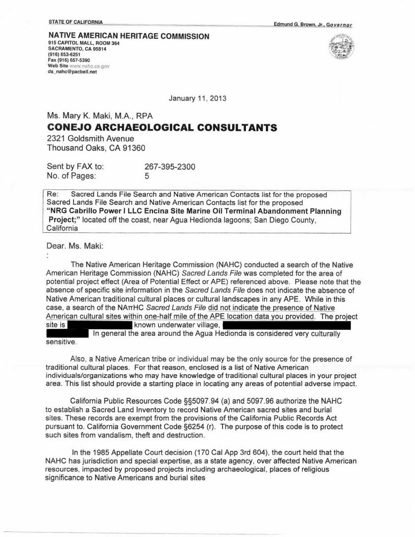
Native American Heritage Commission letter to Conejo Archaeological Consultants (January 11, 2013)
Sample letter to Native American Representatives on the Subject of NRG Cabrillo Power I LLC Encina Site Marine Oil Terminal Abandonment Planning Project, Carlsbad, San Diego County (directed to San Pasqual Band of Mission Indians, January 30, 2013)
Letter from Pala Tribal Historic Preservation Office to Conejo Archaeological Consultants (February 20, 2013)
Telephone Record between Conejo Archaeological Consultants and Cami Mojado, San Luis Rey Band of Mission Indians (February 25, 2013)
Letter from Rincon Band of Luiseno Indians to Conejo Archaeological Consultants (March 5, 2013)
A Cultural Resources Evaluation for the Cabrillo Power I LLC Encina Site Offshore Marine Oil Terminal, Carlsbad, San Diego County, prepared by John Minch and Associates, Inc. (February 19, 2013)
Letter from the California State Lands Commission’s Executive Office Notifying Native American Representatives of the Cabrillo Power I LLC Encina Marine Oil Terminal Decommissioning Project (October 2, 2015)
January 18, 2013
Donna Hebert Padre Associates, Inc. 1861 Knoll Drive Ventura, CA 93003
Subject: Record Search Results for the Cabrillo I LLC Encina Site Marine Oil Terminal Abandonment Plan, City of Carlsbad, San Diego County
Dear Ms. Hebert:
Per your request, Conejo Archaeological Consultants (Conejo) has completed a records search at
the South Coastal Information Center (SCIC) for the above project. In addition, Federal, state and
local historic listings were reviewed. This investigation also included a review of the California
State Lands Commission's shipwreck database. The findings of this investigation are summarized
below.
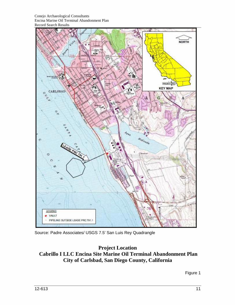
Project Location & Description
The Encina Power Station (EPS) was constructed in 1953 as an oil burning, steam generating
electric power generation plant. In order to transfer fuel, an offshore marine terminal (MOT) was
also constructed in 1953. The power plant converted to the use of natural gas as a fuel source, but
the offshore terminal was retained to provide an alternative fuel source as required by the
California Independent System Operator. This requirement is no longer in place and the need to
maintain the offshore terminal has ceased. Therefore, planning for abandonment of the offshore
terminal has begun. The EPS address is 4600 Carlsbad Avenue, Carlsbad, California. The project
site location is shown on Figure 1.
The MOT is on land leased by the California State Lands Commission (CSLC) referenced as
Lease PRC 791.1 (Figure 1) and consists of a 7-point mooring and a single 20-inch diameter
submarine pipeline to the shore facility. The submarine pipeline runs ashore approximately 350
feet to the north of the power station structure as viewed from the mooring. The onshore portion
of the pipeline at the beach is covered with a substantial amount of rip-rap. The pipeline crosses
under Carlsbad Boulevard (State Route 1) and can be accessed via an open vault structure within
CONEJO
ARCHAEOLOGICAL
CONSULTANTS
2321 Goldsmith Avenue Thousand Oaks, California 91360 805/494-4309 [email protected]
Conejo Archaeological Consultants Encina Marine Oil Terminal Abandonment Plan Record Search Results
12-613 2
the power plant. The vault measures approximately 12 feet by 11 feet and is approximately 10
feet deep.
The project location is outlined on the USGS 7.5’ San Luis Rey Quadrangle in Figure 1, and lies
within the historic boundaries of Mexican Land Grant Rancho Agua Hedionda, Township 12S
and Range 4W.
South Coastal Information Center Records Search
The general project area is sensitive for archaeological resources. A records search for the
Carlsbad Energy Center Project, located within the northeast section of the EPS, identified 35
archaeological sites within a one-mile radius (California Energy Commission, 2009:4.3-13).
Nick Doose, the SCIC GIS Coordinator, conducted a rush records search for this project on
January 15, 2013. A 0.25-mile radius was used for this linear project site. The record search
results are attached under Appendix A.
Prehistoric & Historic Archaeological Sites
One archaeological site is recorded within a 0.25-mile radius of the project site as described
below.
CA-SDI-16885 is a small, sparse scatter of artifacts with shell on a bluff overlooking the
western portion of Agua Hedionda lagoon. The site was first recorded by Gallegos &
Associates in 2003 (James et. al 2003). Tift (2004) indicates that the site is probably
associated with CA-SDI-6751 , located approximately , and SA-
SDI-210 located approximately .
Smallwood's 2005 CA-SDI-16885 site record update notes:
Historic photographs of the EPS [Encina Power Station] revealed that prior to its
construction the entire property had been graded, some areas were leveled and
filled, a stream was channelized, the lagoon was dredged, and a large
underground intake was constructed to bring water into the plant from the
ocean...In short, the entire EPS property has received a high level of disturbance.
Geological borings in the area revealed that the soils at Site CA-SDI-16885 are
composed of reddish brown sandy terrace material that has been mechanically
re-deposited as fill to a depth of approximately 2.5 to 10 feet (ibid.). In light of
the information obtained from historic photographs and the results of the
geological borings, it is apparent that these surface artifacts were mechanically
Conejo Archaeological Consultants Encina Marine Oil Terminal Abandonment Plan Record Search Results
12-613 3
re-deposited during the previous grading that occurred on the EPS property,
beginning in the 1950s. Artifacts may be present subsurface in the fill soils at
this location, but it has been determined that the artifacts observed at the site do
not exhibit any contextual integrity. However, additional artifacts or
archaeological deposits may exist subsurface in undisturbed soils near Fuel Oil
Tanks #2 and #3.
The Agua Hedionda lagoon lies in an area where, at least during the Late
Prehistoric and Protohistoric periods, the traditional territories of two Native
American groups, the Luiseno and the Kumeyaay, may have overlapped...In any
case, the site is indicative of prehistoric occupation, food processing activities,
and subsistence strategies associated with the lagoon and terrace resources.
CA-SDI-16885 is located approximately of the vault and will not be
impacted by project implementation.
It is important to note that although the SCIC site record map only plotted CA-SDI-16885 within
a 0.25-mile radius of the EPS project site, there is an indication that a second archaeological site,
CA-SDI-210, may be located within close proximity to the vault as described below.
CA-SDI-209. The CA-SDI-16885 site record form includes a site map that shows CA-
SDI-210 within the Encina Power Plant (See Figure 2). The CA-SDI-16885 site record
also states that CA-SDI-210 is located (Tift 2004).
Conejo contacted the SCIC for additional information on CA-SDI-210. The SCIC
provided the site record for CA-SDI-210 and noted in the email:
Attached is the site record for SDI-210, it does not have a map, it refers to SDI-209 for a map, but
the map in SDI-209 does not show any sites in this area (Doose personal communication).
In addition to having no map, the CA-SDI-210 site record provides minimal information limited to
the following:
• Township 11S, Range 4W
• Location (See map with 209)
• Contour Elevation .
• Nearest Water Agua Hedionda Creek
• Recorded by Treganza
Conejo Archaeological Consultants Encina Marine Oil Terminal Abandonment Plan Record Search Results
12-613 4
The Universal Transverse Mercator (UTM) numbers listed above are the most useful information
the site record provides. When Zone 11, is plotted it places CA-SDI-210
approximately of the vault, and
as noted in the CA-SDI-210 site record.
Larry Tift, who helped prepare the archaeological site record form, was contacted and asked what
information he used to plot CA-SDI-210 within the EPS. Mr. Tift's email response is provided
below:
That is definitely my site form, so I PERSONALLY drew that boundary for SDI-
210 - but I am afraid I do not recall! We had our own in-house record search
maps, that we were pretty good about keeping updated. We had an extensive
regional CRM library, so the location may have come from an archived report (a
previous, regional study), or from another, institutional source. This area was of
special interest to Dennis Gallegos, so he had compiled pretty comprehensive
data on the area - I believe I can say that wherever it came from, this location
was pretty well considered, although of course some of these earlier sites were
only sketchily (word?) documented at best! So what this location may represent
is the best anyone can/could have guessed!!
The location of CA-SDI-210 is unclear, but based on the information gathered in this investigation it is
assumed that the archaeological site is located . Review
of Google Earth's aerial coverage of the EPS also make it clear that CA-SDI-210's estimated site location
was subject to extensive grading during construction of the existing plant. However, there is a possibility
that buried intact deposits associated with CA-SDI-210 may occur within the EPS.
Previous Archaeological Investigations
Eight archaeological investigations have been conducted within a 0.25-mile radius of the project
site. Three of these investigations included sections of the on land portion of the project area
consisting of the beach and Carlsbad Boulevard:
• Bryd, Brian F. and Collin O'Neill, 2002;
• Polan, Keith, 1981; and
• Woodward, Jim and George Stammerjohan, 1985.
Guerrero, Stropes and Gallegos's 2004 archaeological investigation was located within the EPS
but did not include the current project site.
Conejo Archaeological Consultants Encina Marine Oil Terminal Abandonment Plan Record Search Results
12-613 5
Federal, State and Local Historical Listings
The National Register of Historic Places (NRHP) listings include no properties within or adjacent
to the project site (National Park Service 2013). No California Historical Landmarks, California
Register Historical Properties or California Points of Historical Interest are located within or
adjacent to the project site (Office of Historic Preservation 2013). No City of Carlsbad
designated historical landmarks are located within or adjacent to the project site (City of Carlsbad
2013).
California State Lands Commission's Shipwreck Database
SCIC's shipwreck database review identified no shipwrecks within a 0.25-mile radius of the
project site.
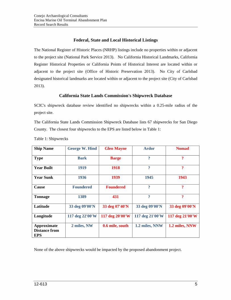
The California State Lands Commission Shipwreck Database lists 67 shipwrecks for San Diego
County. The closest four shipwrecks to the EPS are listed below in Table 1:
Table 1: Shipwrecks
Ship Name George W. Hind Glen Mayne Ardor Nomad
Type Bark Barge ? ?
Year Built 1919 1918 ? ?
Year Sunk 1936 1939 1945 1943
Cause Foundered Foundered ? ?
Tonnage 1389 431 ? ?
Latitude 33 deg 09'00'N 33 deg 07'40'N 33 deg 09'00'N 33 deg 09'00'N
Longitude 117 deg 22'00'W 117 deg 20'00'W 117 deg 21'00'W 117 deg 21'00'W
Approximate Distance from EPS
2 miles, NW 0.6 mile, south 1.2 miles, NNW 1.2 miles, NNW
None of the above shipwrecks would be impacted by the proposed abandonment project.
Conejo Archaeological Consultants Encina Marine Oil Terminal Abandonment Plan Record Search Results
12-613 6
Summary
The EPS is located with a general area considered sensitive for archaeological resources. A
previous project in the northeast section of the EPS identified 35 archaeological sites within a
one-mile radius. However, the onshore portion of the current project is associated with the
abandonment of existing facilities including a 10 foot deep vault and buried pipeline onshore.
Excavation associated with the construction of the vault and trenching for the pipeline would
have destroyed the contextual integrity of any (if present) archaeological resource within the
original construction impact zone.
The current investigation identified two prehistoric sites, CA-SDI-210 & CA-SDI-16885, within
a 0.25-mile radius of the project site. The exact location of CA-SDI-210 is somewhat
speculative, but based on available information Gallegos & Associates have placed the site
(Tift personal communication).
Unfortunately, extensive grading and the lack of ground surface visibility within the onshore
portion of the project site render a Phase 1 Archaeological Survey unfeasible. If project related
earth disturbances extend outside of the previously disturbed construction areas, vertically or
horizontally, then there is a potential that intact buried deposits associated with CA-SDI-210
could be impacted.
CA-SDI-16885 is located and will not be
impacted by project implementation.
No shipwrecks are recorded within a 0.5-mile radius of the pipeline.
The EPS MOT was built in 1953 and is over 60 years old. The current plan consists of the
abandonment of the vault, pipeline and moorings. Under CEQA Guidelines, a resource is
generally considered to be historically significant if it meets the criteria for listing in the
California Register of Historic Resources (CRHP). These criteria are essentially the same as the
eligibility criteria for the National Register of Historic Places (NRHP). In addition to being at
least 50 years old, a resource must meet at least one of the following four criteria: is associated
with events that have made a significant contribution to the broad patterns of our history
(Criterion 1); or, is associated with the lives of persons significant in our past (Criterion 2); or,
that embodies the distinctive characteristics of a type, period, or method of construction, or
represents the work of a master, or possesses high artistic values (Criterion 3); or, that has
yielded, or may be likely to yield, information important to history or prehistory (Criterion 4)
(Public Resources Code § 5024.1). In addition, historical resources must also possess integrity of

Conejo Archaeological Consultants Encina Marine Oil Terminal Abandonment Plan Record Search Results
12-613 7
location, design, setting, materials, workmanship, feeling, and association (California Code of
Regulations, Title 14, § 4852[c]).
The vault, pipeline and moorings meet the 50 year age requirement and possibly Criterion 1 as
contributing features to the EPS MOT.
Based on the results of this records search in combination with the extent of previous ground
disturbances within the project site, the following recommendations are made:
1. Conduct a Native American Heritage Commission (NAHC) Sacred Lands File Check for
the project and provide project description letter to all Native Americans contacts provided
by the NAHC.
2. A historic archaeologist should be retained to complete the Department of Parks and
Recreation (DPR) Form 523b- Building, Structure, Object, Record for any MOT features
that would be destroyed or altered under the final abandonment plan. The historic
archaeologist shall also determine the significance or lack thereof for these features and
provide recommendations as appropriate.
3. Limit all construction impacts to the previously disturbed area. If project impacts will
extend outside of and/or deeper than the original excavation for the vault, an Extended
Phase 1 Archaeological Subsurface Excavation should be conducted within those
previously undisturbed areas to determine the presence or absence of cultural resources.
4. Retain an archaeologist and Native American consultant to monitor all onshore project
related excavation. Monitoring within the previously disturbed area will allow the
archaeologist to note the presence or absence of cultural resources and may help determine
if CA-SDI-210 is in the immediate project vicinity.
A. At the commencement of project construction, the archaeological monitor
shall give all workers associated with earth-disturbing procedures an
orientation regarding the probability of exposing cultural resources and
directions as to what steps are to be taken if a find is encountered.
B. The archaeologist shall have the authority to temporarily halt or redirect
project construction in the event that potentially significant cultural resources
are exposed. Based on monitoring observations and the actual extent of
project disturbance, the lead archaeologist shall have the authority to refine
Conejo Archaeological Consultants Encina Marine Oil Terminal Abandonment Plan Record Search Results
12-613 8
the monitoring requirements as appropriate (i.e., change to spot checks,
reduce or increase the area to be monitored) in consultation with the client.
C. A monitoring report shall be prepared upon completion of construction and
provided to the SCIC.
5. In the event that archaeological resources are discovered during project construction, all
earth disturbing work within the vicinity of the find must be temporarily suspended or
redirected until a professional archaeologist has been retained to evaluate the nature and
significance of the find. The District shall be notified immediately of any such find. After
the find has been appropriately mitigated, work in the area may resume. A Native
American representative should monitor any mitigation work associated with Native
American cultural material.
6. If human remains are unearthed, State Health and Safety Code Section 7050.5 requires
that no further disturbance shall occur until the County Coroner has made the necessary
findings as to origin and disposition pursuant to Public Resources Code Section 5097.98.
If the remains are determined to be of Native American descent, the coroner has 24 hours to
notify the Native American Heritage Commission (NAHC). The District shall be notified
immediately of the find.
If the project's potential impact area expands beyond its current limits, then additional
archaeological investigation may be required.
Please call if you have any questions regarding the record search findings. Thank you for you
using Conejo Archaeological Consultants for your cultural resource management needs.
Sincerely,
Mary K. Maki, M.A., RPA Archaeologist
Conejo Archaeological Consultants Encina Marine Oil Terminal Abandonment Plan Record Search Results
12-613 9
Sources Cited Bryd, Brian F. and Collin O'Neill
2002 Archaeological Survey Report for the Phase 1 Archaeological Survey along Interstate 5 San Diego County, CA. Unpublished report on file at the South Coastal Information Center, San Diego State University.
California Energy Commission
2009 Final Staff Assessment, Carlsbad Energy Center Project, Application for Certification (07-AFC-6, San Diego County. http://www.energy.ca.gov/2009publications/CEC-700-2009-017/CEC-700-2009-017-FSA.PDF.
Carlsbad, City of
2013 Historic Carlsbad. http://www.carlsbadca.gov/services/departments/library/about-us/Pages/historic-carlsbad.aspx
Guerrero, Monica C., Tracy Stropes, and Dennis R. Gallegos
2004 Cultural Resource Monitor and Test Report for the Encina Power Plant Project, Carlsbad, California. Unpublished report on file at the South Coastal Information Center, San Diego State University.
Hector, Susan
2007 Encina-Penasquitos Transmission Line Records Search. Unpublished report on file at the South Coastal Information Center, San Diego State University.
James, Del, Monica Guerrero and Larry Tift.
2003 CA-SDI-16885 Primary Record Form. On file at the South Coastal Information Center, San Diego State University.
National Park Service
2013National Register of Historic Places. Carlsbad, San Diego County, California. http://nrhp.focus.nps.gov/natreghome.do.
Office of Historic Preservation, California Department of Parks and Recreation
2013 California Historical Resources, San Diego County.
http://ohp.parks.ca.gov/ListedResources/?view=county&criteria=37
2012b Directory of Properties in the Historic Property Data File for Santa Barbara County, 04-05-12
Polan, H. Keith
1981 Carlsbad Boulevard: An Archaeological Survey Report of the Right-of-Way for Proposed Bridge and Street Improvements Between Tamarack Avenue and Cannon Road, Carlsbad, California. Unpublished report on file at the South Coastal Information Center, San Diego State University.
Smallwood, John
2005a CA-SDI-16885 Update. On file at the South Coastal Information Center San Diego State University.
Conejo Archaeological Consultants Encina Marine Oil Terminal Abandonment Plan Record Search Results
12-613 10
2005b Archaeological/Paleontological Monitoring of Boring Activities San Diego Water Authority's Seawater Desalination Project, Encina Power Station, City of Carlsbad, San Diego county, California. Unpublished report on file at the South Coastal Information Center, San Diego State University.
Tift, Larry
2004 CA-SDI-16885 Archaeological Site Record. On file at the South Coastal Information Center, San Diego State University.
Woodward, Jim and George Stammerjohan
1985 Resource Inventory Cultural Resources San Diego Coast State Beaches. Department of Parks and Recreation. Unpublished report on file at the South Coastal Information Center, San Diego State University.
Individuals and Institutions Contacted
Doose, Nick, GIS Coordinator, South Coastal Information Center, email dated January 16, 2013.
Tift, Larry, Archaeologist, ASM Affiliates, email dated January 18, 2012.
Conejo Archaeological Consultants Encina Marine Oil Terminal Abandonment Plan Record Search Results
12-613 11
Source: Padre Associates/ USGS 7.5' San Luis Rey Quadrangle
Project Location Cabrillo I LLC Encina Site Marine Oil Terminal Aba ndonment Plan
City of Carlsbad, San Diego County, California
Figure 1
STATE QF CALIEOFIiIIA
NATIVE AMERICAN HERITAGE COMMISSION915C PrOL MArt, FOOM 364SACRAMENTO, CA 958t4(915) 653{251
W.b Sil€. ,.1 .., ,,-.,
January'11,2013
Ms. Mary K. Maki, M.A., RPA
GONEJO ARCHAEOLOGICAL GONSULTANTS2321 Goldsmith AvenueThousand Oaks, CA 91360
Ednund G,!rown, ,tr- Go /.rrot
#e*.,.9,
Sent by FAX to:No. of Pages:
267-395-2300
Re: Sacred Lands File Search and Native American Contacts list for the proposedSacred Lands File Search and Native American Contacts list for the proposed
| "NRG Cabrillo Power I LLC Encina Site Marine Oil Terminal Abandonment PlanningProiect;" located off the coast. near Agua Hedionda lagoons, San Diego County.
Calfornia
Dear. Ms. Maki::
The Native American Heritage Commission (NAHC) conducted a search of the NativeAmerican Heritage Commission (NAHC) Sacred Lands File was completed for the area ofpotential project effect (Area of Potential Effect or APE) referenced above. Please note that theabsence of specific site information in the Sacred Lands File does not indicate the absence ofNative American traditional cultural places or cultural landscapes in any APE. While in thiscase, a search of the NAIHC Sacred Lands Frle d jfugt ircllqate lttlq p@-senQqof l)btjyeAlnerilq! cqllqral q!!es t4!!hi! olq-half mile of the APE l,olaljgn !Le!a yqqprovjdqd. The projectsite is known underwater village,
. ln general the area around the Agua Hedionda is considered very culturallysensitive.
Also, a Native American tribe or individual may be the only source for the presence oftraditional cultural places. For that reason, enclosed is a list of Native Americanindividuals/organizations who may have knowledge oftraditional cultural places in your projectarea. This list should provide a starting place in locating any areas of potential adverse impact.
California Public Resources Code 555097.94 (a) and 5097.96 authorize the NAHCto establish a Sacred Land lnventory to record Native American sacred sites and burialsites. These records are exempt from the provisions of the California Public Records Actpursuant to. California Government Code 56254 (r). The purpose ofthis code is to protectsuch sites from vandalism, theft and destruction.
ln the 1985 Appellate Court decision (170 CalApp 3rd 604), the court held that theNAHC hasjurisdiction and special expertise, as a state agency, over affected Native Americanresources, impacted by proposed projects including archaeological, places of religioussignificance to Native Americans and burial sites
The California Environmentat Quatity Act (CEeA - CA pubtic Resources Code SS21000-21177, amendments effective 3/18/2010) requires that any project that causes asubstantial adverse change in the significance of an historical resource, that includesarchaeological resources, is a 'signiflcant effect' requiring the preparation of an Environmentallmpact Report (ElR) per the CEQA Guidetines defines a significant impact on the environmentas 'a substantial, or potentially substantial, adverse change in any of physical conditions withinan area affected by the proposed project, including ... objects of historic or aestheticsignificance.' ln order to comply with this provision, the lead agency is required to assesswhether the project will have an adverse impact on these resources within the 'area ot potentialeffect (APE), and if so, to mitigate that effect. CA Government Code 565040.12(e) defines"environmental justice" provisions and is applicable to the environmental review processes. TheNAHC recommends ayodarce as defined by CEQA Guidetines S15370(a) to pursuing a projectthat would damage or destroy Native American cultural resources and California PublicResources Code Section 21083.2 (Archaeological Resources) that requires documentation,data recovery of cultural resources, construction to avoid sites and the possible use of covenanteasements to protect sites.
Early consultation with Native American tribes in your area is the best way to avoidunanticipated discoveries once a project as underway. Local Native Americans may haveknowledge ofthe religious and cultural significance ofthe historic properties of the proposedproject for the area (e.9. APE). Consultation with Native American communities is also a matterof environmental justice as detined by California covernment Code 565040.12(e). We urgeconsultation with those tribes and interested Native Americans on the list that the NAHC hasprovided in order to see if your proposed project might impact Native American cultrtratresources. Lead agencies should consider alddan@ as defined in S15370 ofthe CEQAGuidelines when significant cultural resources as defined by the CEQA Guldelines S'15064.5(b)(c)(D may be affected by a proposed project. lf so, Section 15382 of the CEOA Guidelinesdefines a significant impact on lhe environment as "substantial," and Section 2'1083.2 whichrequires documentation, data recovery of cultural resources.
The NAHC makes no recommendation or preference of any single individual, or groupover another. All of those on the list should be contacted, if they cannot supply information, theymight recommend others with specific knowledge. By contacting allthose listed, yourorganization will be better able to respond to claims of failure to consult with the appropriatetribe orgroup. lf a response has not been received within two weeks of notification, the NAHCrequests that you follow-up with a telephone call to ensure that the project information has beenreceived-
The 1992 Secretary of the Inteiors Standards lor the Trcatnent of Histoic Propeftieswere revised so that they could be applied to all historic resource types included in the NationalRegister of Historic Places and including cultural landscapes. Also, federal Executive OrdersNos. 11593 (preservation of cultural environment), 13175 (coordination & consultation) and13007 (Sacred Sites) are helpful, supportive guides for Section 106 consultation. Theaforementioned Secretary ofthe lnterior's Slardards include recommendations for all 'leadagencies' to consider the [iq!orig!q! eI! of proposed projects and to "research" the qu!!q?lland!.cap€ that might include the 'area of potential effect.'
Partnerlng with local tribes and interested Native American consulting parties, on theNAHC list, should be conducted in compliance with the requirements of federal NEPA (42 U.S.C4321-43351) and Section 1064(D, Section 110 and (k) ofthe federal NHPA (16 U.S.C. 470 efseg), Section 4(f) of the Department of Transportation Act of 1966 (23 CFR 774); 36 CFR Part
800.3 (D (2) &.5, the President's Councilon Environmentat euatity (CSe,42 U.S.C 437,1 etseg. and NAGPRA (25 U.S.C. 3001-3013) as appropriate. The 1992 Secretary of the tnte(iotsStandards for the Treatment of Hisloic Properlies were revised so that they could be applied toall historic resource types included in the National Register of Historic places and includingcultural landscapes. Also, federal Executive Orders Nos. 1 1593 (preservation of culturalenvjronment), 13175 (coordination & consultation) and 13007 (Sacred Sites) are helpful,supportive guides for Section 105 consultation. The NAHC remains concemed aboutthelimitations and methods employed for NHPA Section 106 Consultation.
Also. Calitornia Public Resources Code Section 5097.98, California Government Code52749'1 and Health & Safety Code Section 7050.5 provide for provisions for accidentallydiscovered archeological resources during construction and mandate the processes to befollowed in the event of an accidental discovery of any human remains in a project location otherthan a 'dedicated cemetery', another importanl reason io have Native American Monitors onboard wlth the project.
To be effective, consultation on specitic projects must be the result of an ongoingrelationship between Native American tribes and lead agencies, project p.oponents and their
contractors, in lhe opinion ofthe NAHC. An excellent way to reinforce the relationship betweena project and local tribes is to employ Native American Monitors in all phases of proposedprojects including the planning phases.
Confidentiality of "historic properties of religious and cultural significance" may also beprotected under Section 304 of he NHPA or at the Secretary of the lnterior discretion if noteligible for listing on the National Register of Hisloric Places. The Secretary may also beadvised by the federal lndian Religious Freedom Act (cf. 42 U.S.C., 1996) in issuing a decisionon whether or not to disclose items of religious and/or cultural significance identitied in or nearthe APE and possibility threatened by proposed project activity.
lf you receive notification of change of addresses and phone numbers from any of theseindividuals or groups, please notify me. With your assistance we are able to assure that ourlists contain current informalion. lfyou have any questions about this response to your request,please do not hesitale to contact me at (916) 653-6251.
Sincerely,
Dave Singleton
Attachment: Native American Contact List
Barona Group of the Capitan GrandeEdwin Romer airperson
ad Lakeside CA 92040
Native American ContactsSanDiego CountyJanuary 11, 2013
Pauma & Yuima ReservationRandall Nlajel, ChajrpersonP.O. Box 369 LuisenoPauma Valley CA 92061
San Pasqual Band ol Mission lndians Pechanga Band of Mission lndiansAllen E. Lawson, Chairperson Paul Macarro, Cultural Resources ManagerPO Box 365 Diegueno P.O. Box1477 Luiseno
Temecula CA 92593lband.com
Mesa Grande Band of lvlission lndians Rincon Band ol Mission lndiansMark Romero, Chairperson Vincent Whipple, Tribal Historic Preationv. OfficerP.O Box 27O Diegueno P.O. Box 68 Luiseno
O Valley Center, CA [email protected]
Pala Band of Mission lndians Kwaaymii Laguna Band of Misslon lndiansHistoricPreservationOffice/ShastaGaughen CarmenLucas
d, LUiSenO P.O. Box 775 Diegueno -Pala ' CA 92059 Cupeno Pine Valley ' CA91962PMB 50
Thi3 list is curent only a3 ol th€ date or thi3 docutr€nt.
Obt bution of this llst do€6 not rslisvo any porson of th6 3iatutory respoEibillty as d€flEd in S6tion 7050,5 of th€ Health and Safety Code,
Seciion 5097.94 ot the Public Resourc€s Code and S€ction 5097.98 ofth€ Pubric R6ources Co(b.
ThI3 lbt is appllcable for contactlng local Native AmedcaB with Egard to clltural resources to. the proposed
NRG Cabrillo Porver I LLC Encina St f.dn€ Oil forminal Abandonmedt Planning P.oject; locatod oft lhe San Dlego County coa3tat the city ot Caftbad, Calltornla tor wnlch a SacFd LandB Fil6 search anlt Natlve ame.lcan contacb w6re requested.
Rincon Band of l\rission lndiansBo Mazzetti, ChairpersonP.O. Box 68Valley Center, CA 92082
Luiseno
San Pasqual Band of lndiansKristie Orosco, Environmental CoordinatorP.O. Box 365 DieguenoValley Center, CA 92082
San Luis Bev Band of lvlission lndiansCultural Dep-
e LuisenoVista CA 92081 Cupeno
lpay Nation of Santa YsabelClint Linton. Director of Cultural ResourcesP.O. Box 507 Diegueno/KumeyaaySanta Ysabel, CA 92070
Native American ContactsSanDiego CountyJanuary 11, 2013
Kumeyaay Cultural Repatriation CommitteeBernice Paipa e Spokesperson
ad Diegueno/KumeyaayLakeside CA s2040
(KCRC is a Colation of 12Kumeyaay Governments
This list is cun ntonly as of the date ot tnis docum€nt.
Olltribution of thi3 list do€s not r€lievo any p€Eon of th€ staMory rs3ponsibality as .letined ln S€cllon 7050,5 of th€ Health end Saf.ty Code,Sootion 5097.94 of the Public Ro.ourc€. Cod6.n.l Soctlon 5097.98 ol the Public Resourc6 Code-
Thls list b applic:ble for cont otlng local llative Arericans w n regErd to cultulal r6ourc€. for tte prcpd€dNRGcabrlllo Pder' LLC EnclnaSit€ lu..ine OllTermlnal Ab.ndonmont Plannlng ProJocr; located ofl th€ San Diego County coast.t the cig ot carl.bdd, Califomi. fo. whlch 5 SscEd lrnds Filo s€a.ch .nd I'Ltive Am.ridn contacb r€6 requ€6t d.
January 30, 2013
San Pasqual Band of Mission Indians Allen E. Lawson, Chairperson P.O. Box 365 Valley Center, CA 92080 Subject: NRG Cabrillo Power I LLC Encina Site Marine Oil Terminal Abandonment
Planning Project, Carlsbad, San Diego County Dear Chairperson Lawson:
On behalf of Padre Associates, Conejo Archaeological Consultants is conducting a records search
for the above project.
The Encina Power Station (EPS) was constructed in 1953 as an oil burning, steam generating
electric power generation plant. In order to transfer fuel, an offshore marine terminal (MOT) was
also constructed in 1953. The power plant converted to the use of natural gas as a fuel source, but
the offshore terminal was retained to provide an alternative fuel source as required by the
California Independent System Operator. This requirement is no longer in place and the need to
maintain the offshore terminal has ceased. Therefore, planning for abandonment of the offshore
terminal has begun. The EPS address is 4600 Carlsbad Avenue, Carlsbad, California. The project
site location is shown on Figure 1.
The MOT is on submerged land leased by the California State Lands Commission (CSLC) and
consists of a 7-point mooring and a single approximately 0.5 mile long, 20-inch diameter
submarine pipeline to the shore facility. The onshore portion of the current project is associated
with the abandonment of existing facilities including a 10 foot deep vault and approximate 350
feet of buried pipeline. The majority of the onshore pipeline is located within Carlsbad State
Beach, with a short length crossing underneath Carlsbad Boulevard to the EPS shore facility.
Please respond if you have any information on cultural resources within the project site or
specific project concerns. My email address and phone number are located on the letterhead. All
responses shall be forwarded to Padre Associates. Thank you for your time.
Sincerely,
Mary K. Maki, M.A., RPA Archaeologist
CONEJO
ARCHAEOLOGICAL
CONSULTANTS
2321 Goldsmith Avenue Thousand Oaks, California 91360 805/494-4309 [email protected]

Conejo Archaeological Consultants Encina Marine Oil Terminal Abandonment Plan
12-614 2
Source: USGS 7.5' San Luis Rey Quadrangle

Consultation letter 3
PALA TRIBAL HISTORIC
PRESERVATION OFFICE
PMB 50, 35008 Pala Temecula Road
Pala, CA 92059
760-891-3510 Office | 760-742-3189 Fax
February 20, 2013
Mary K. Maki
Conejo Archaeological Consultants
2321 Goldsmith Ave
Thousand Oaks, CA 91360
Re: NRG Cabrillo Power I LLC Encina Site Marine Oil Terminal Abandonment Planning Project
Dear Ms. Maki:
The Pala Band of Mission Indians Tribal Historic Preservation Office has received your notification of
the project referenced above. This letter constitutes our response on behalf of Robert Smith, Tribal
Chairman.
We have consulted our maps and determined that the project as described is not within the boundaries of
the recognized Pala Indian Reservation. The project is also beyond the boundaries of the territory that the
tribe considers its Traditional Use Area (TUA). It is, however, situated in close proximity to the
Reservation and information generated would likely be useful in better understanding regional culture and
history. Therefore, we request as a courtesy to be kept in the information loop as the project progresses
and would appreciate being maintained on the receiving list for project updates, reports of investigations,
and/or any documentation that might be generated regarding previously reported or newly discovered
sites. Further, if the project boundaries are modified to extend beyond the currently proposed limits, we
do request updated information and the opportunity to respond to your changes.
We appreciate involvement with your initiative and look forward to working with you on future efforts. If
you have questions or need additional information, please do not hesitate to contact me by telephone at
760-891-3515 or by e-mail at [email protected].
Sincerely,
Shasta C. Gaughen, PhD
Tribal Historic Preservation Officer
Pala Band of Mission Indians
ATTENTION: THE PALA TRIBAL HISTORIC PRESERVATION OFFICE IS RESPONSIBLE FOR ALL
REQUESTS FOR CONSULTATION. PLEASE ADDRESS CORRESPONDENCE TO SHASTA C. GAUGHEN
AT THE ABOVE ADDRESS. IT IS NOT NECESSARY TO ALSO SEND NOTICES TO PALA TRIBAL
CHAIRMAN ROBERT SMITH.
Telephone Record
Date: February 25, 2013
Time: 3:10 to 3:16
Caller: Mary Maki, Conejo Archaeological Consultants, 805-494-4309
Called: Cami Mojado, San Luis Rey Band of Mission Indians,
Project: NRG Cabrillo Power I LLC Encina Site Marine Oil Terminal Abandonment Planning Project,
Carlsbad, San Diego County
Notes from telephone conversation:
Passed on the following information from Donna Hebert of Padre Associates to Ms. Mojado .
• The current work scope for the Abandonment Plan has changed to removal of the
anchors and chains, and is limited to offshore work.
• Explained that her earlier comments (Telephone Record) will be included in the
environmental documentation that Padre Associates is providing the State Lands
Commission. Also, noted that the States Lands Commission will undertake any future
project notifications.
If the project changes to include onshore work, Ms. Mojado requested that she again be contacted.
Cami Mojado

A CULTURAL RESOURCES EVALUATION OF THE CABRILLO POWER I LLCENCINA SITE OFFSHORE MARINE OIL TERMINAL, CARLSBAD,
SAN DIEGO COUNTY
Prepared for:
Sheila Henika, P.E.NRG Cabrillo Power LLC
Encina Site4600 Carlsbad Boulevard
Carlsbad, CA 92008
Prepared by:
Robert S. WhiteLaura S. White, M.A.
John Minch and Associates, Inc.26623 Sierra Vista
Mission Viejo, CA 92692
Tel: (949) 367-1000Fax: (949) 367-0117
February 19, 2013
Study Area USGS 7.5' Topographic Quadrangle: San Luis ReyUnsectioned, Township 11 South, Range 4 West, SBBM
KEYWORDS: Historical Evaluation, Primary #37-032953, Offshore Marine Oil Terminal, Encina Power Station, Carlsbad, San Diego County
The undersigned certifies that the attached report is a true and accurate description of the resultsof a CULTURAL RESOURCES EVALUATION described herein.
.............................…Laura S. White, M.A.Principal Investigator
i
TABLE OF CONTENTS
PAGE
Management Summary. . . . . . . . . iii
I. INTRODUCTION. . . . . . . . . 1
II. LOCATION . . . . . . . . . 1
III. BRIEF HISTORY OF ENCINA SITE AND . . . . 3 OFFSHORE MARINE OIL TERMINAL
IV. RECORDS SEARCH. . . . . . . 6
V. DESCRIPTION OF MARINE OIL TERMINAL . . . . 8 AND RELATED FEATURES
VI. RESOURCE EVALUATION . . . . . . . 10
VII. CONCLUSIONS AND RECOMMENDATIONS . . . . 13
REFERENCES CITED. . . . . . . . . 14
APPENDIX A: DPR 523 Forms Package for Primary # 37-032953
ii
LIST OF FIGURES
PAGE
Figure 1. Regional location of the project area as indicated . . . 2on a portion of the Oceanside USGS 1:100,000 scaleTopographic Map Sheet.
Figure 2. Study area indicated on a portion of the San Luis . . . . 4Rey 7.5’USGS Topographic Quadrangle.
Figure 3. Footprint of MOT depicted on aerial photograph . . . . 5
LIST OF PLATES
PAGE
Plate I. Top: Oblique aerial view of Encina site . . . . . 15 during initial phase of construction in 1953 (note pipe yard in top left of photo). Bottom: Close-up of pipeline assembly area.
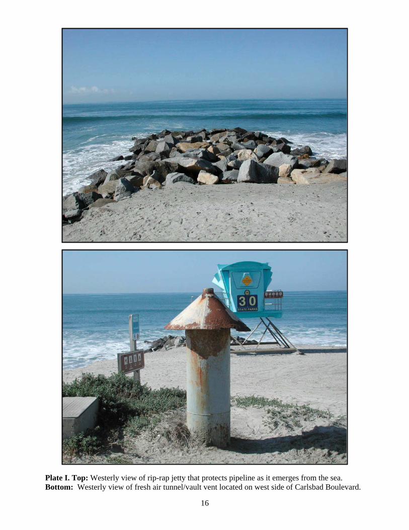
Plate II. Top: Westerly view of rip-rap jetty . . . . . 16that protects pipeline as it emerges from the sea.Bottom: Westerly view of fresh air tunnel/vaultvent located on west side of Carlsbad Boulevard.
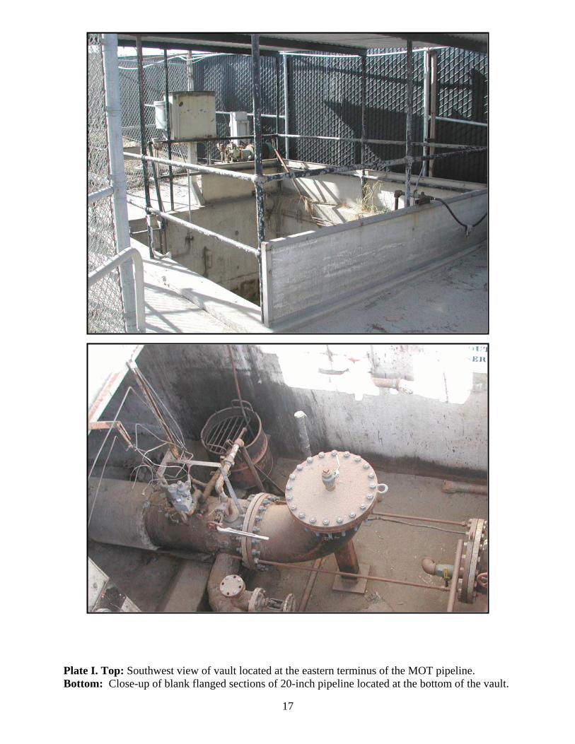
Plate III. Top: Southwest view of vault located . . . . . 17at the eastern terminus of the MOT pipeline.Bottom: Close-up of blank flanged sections of20-inch pipeline located at the bottom of the vault.

iii
MANAGEMENT SUMMARY
At the request of Cabrillo Power I LLC, John Minch and Associates, Inc. (JMA) has
undertaken a cultural resources evaluation of the Encina Site Offshore Marine Oil Terminal
(MOT). The MOT comprises: 1) a 7-point mooring area, 2) approximately 3,850 feet of
concrete jacketed, steel pipeline most of which is submarine, 3) a rip-rap jetty, and 4) a concrete
vault and short section of concrete tunnel. The purpose of this study was to evaluate the MOT
for architectural and historical significance pursuant to both National Register of Historic Places
(NRHP) and California Register of Historical Resources (CRHR) criteria.
The MOT was constructed circa 1954 during the initial phase of development for the
Encina generating station. The MOT is in the process of being abandoned and has been
decommissioned since 2009-10. Consequently, all of the anchor buoys have been removed as
has the 225-foot submarine hose. The pipeline has been sealed and charged with potable water
that contains an anticorrosion agent.
Although the MOT is over fifty years of age, the original seven mooring anchors were
replaced circa 1971. The eighth anchor was positioned in 1979. All of the anchors are
considered modern as they are less than fifty years of age. The anchors and associated chain are
presently laying on the ocean floor in the mooring area.
The results of the architectural and historical assessment have indicated that the MOT
does not appear eligible for either the NRHP or the CRHR. Therefore, the proposed
abandonment program will not have an adverse impact on historical resources. No further work
in conjunction with cultural resources is recommended or warranted in conjunction with the
abandonment program. As a matter of course, the MOT has been recorded on the appropriate
DPR 523 series forms and submitted to the SCIC at San Diego State University. It has been
assigned Primary # 37-032953.
1
I. INTRODUCTION
The following report was prepared for Cabrillo Power I LLC by John Minch and
Associates, Inc. (JMA). It describes the results of a cultural resources evaluation of the Encina
Power Station Offshore Marine Oil Terminal located in Carlsbad, San Diego County. Project
proponents plan to abandon the facility’s offshore terminal which comprises a 7-point mooring
and 3,854 feet of submarine and onshore pipeline that terminates at a concrete vault just inside
the southern power station boundary.
The study described herein was conducted in accordance with the California
Environmental Quality Act (CEQA) as it pertains to the management of cultural resources. The
purpose of the evaluation was to establish the architectural and historical significance of the
various components of the offshore Marine Oil Terminal that are over 50 years of age. This
information is needed since adoption of the proposed abandonment plan could result in adverse
effects upon these structures.
JMA personnel involved in the study included Laura S. White, M.A., RPA (Principal
Investigator), Robert S. White (Project Director), and David Van Horn, Ph.D. Ms. White is a
San Diego County “Approved” Archaeologist and Dr. Van Horn meets the Secretary of the
Interior’s Standards for Architectural History. Our evaluation consisted of: (1) literature review,
(2) archival research, (3) field inspection/architectural analysis of the submarine pipeline and
related features, (4) determinations of architectural and historical significance on the federal and
state levels, and (5) completion of Department of Parks and Recreation (DPR) 523 series forms.
II. LOCATION
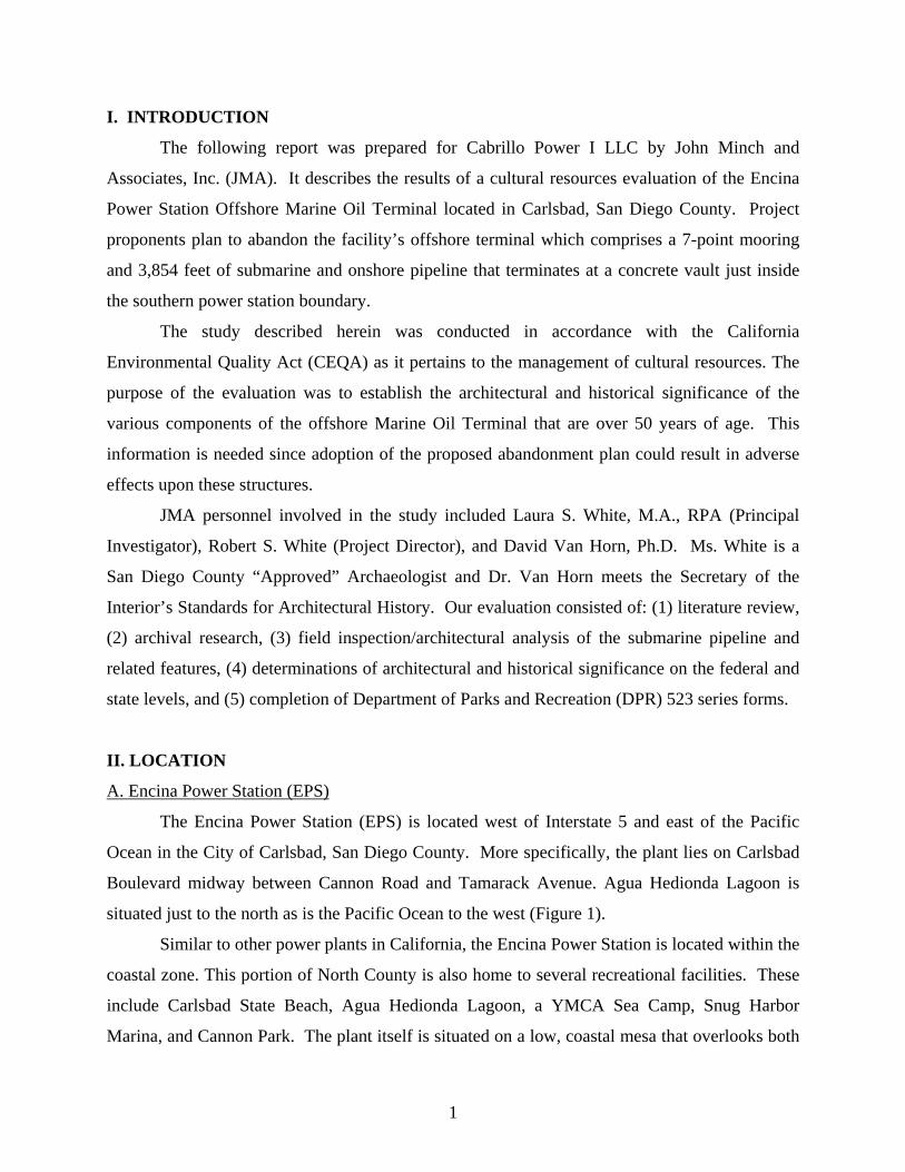
A. Encina Power Station (EPS)
The Encina Power Station (EPS) is located west of Interstate 5 and east of the Pacific
Ocean in the City of Carlsbad, San Diego County. More specifically, the plant lies on Carlsbad
Boulevard midway between Cannon Road and Tamarack Avenue. Agua Hedionda Lagoon is
situated just to the north as is the Pacific Ocean to the west (Figure 1).
Similar to other power plants in California, the Encina Power Station is located within the
coastal zone. This portion of North County is also home to several recreational facilities. These
include Carlsbad State Beach, Agua Hedionda Lagoon, a YMCA Sea Camp, Snug Harbor
Marina, and Cannon Park. The plant itself is situated on a low, coastal mesa that overlooks both

2
Figure 1. Regional location of the project area as indicated on a portion of the Oceanside USGS1:100,000 scale Topographic Map Sheet.
3
Agua Hedionda and the Pacific Ocean (Figure 2). The three basins (inner, middle and outer)
comprising the lagoon are all owned by Cabrillo Power I LLC and provide cooling water for the
facility. The inner basin is popular with hikers and bird watchers. The middle basin is open to
boating, jet skiing, water-skiing and sailboarding. The outer basin contains a sea bass fish
hatchery, mussel farm, and the Hubbs-Sea World Research Institute (ESA 1998).
B. Marine Oil Terminal (MOT)
The offshore MOT is located in the Pacific Ocean on land leased from the California
State Land Commission (CSLC) and referenced as PRC 791.1. The submarine pipeline lies on
the seafloor directly offshore from the Encina Power Station. The onshore portion of the
pipeline extends under a rip-rap jetty and section of beach. It then crosses under Carlsbad
Boulevard to a vault located adjacent to the main entrance to the plant at 4600 Carlsbad
Boulevard (Figures 2 and 3).
III. BRIEF HISTORY OF ENCINA SITE AND OFFSHORE MARINE OIL TERMINAL
A. San Diego Gas and Electric (SDG&E)
In 1953, SDG&E began construction of the Encina Power Plant. It was originally built as
an oil burning, steam generating, electric power station. Of the six generation units, the first
three steam units (Units 1-3) were constructed between 1954 and 1958, each generating over 100
megawatts. Units 4 and 5 were built in the 1970s with a capacity of 300 and 330 megawatts
respectively. Unit 6 was constructed in 1968 and represents the only Gas Turbine unit within the
Plant (CPUC 2010).
In order to provide fuel oil to the Encina Power Plant, SDG&E entered into a lease
agreement with the California State Lands Commission (CSLC) in 1953 for construction of an
offshore marine oil terminal (MOT). Generally, this consisted of a single, 7-point mooring and a
single submarine pipeline that extended to the shore facility (see section V for a complete
description of the MOT components).
By 1990, the power station had converted to natural gas as its primary fuel source. In
conjunction with that transition, the plant retained the offshore terminal to provide bunker fuel
oil as an alternative fuel source as required by the California Independent System Operator (CA
ISO;Scott 2011).

4Figure 2. Study area indicated on a portion of the San Luis Rey 7.5’USGS Topographic Quadrangle.

5
Figure 3. Footprint of MOT depicted on aerial photograph.
6
B. Cabrillo Power I LCC and the Encina Power Plant/Marine Oil Terminal
After operating the Encina Power Plant for over 45 years, SDG&E sold the facility
(including the lease area for the marine oil terminal) to Cabrillo Power in May 1999 as part of a
joint venture between Dynegy and NRG. SDG&E’s original 1953 lease with the CSLS was for a
period of 49 years. It officially expired in March of 2002 but continued in a holdover period.
Subsequently, the Cal ISO removed the requirement that the plant maintain an alternative fuel
source. Therefore, the original need to maintain the offshore marine terminal ceased.
In March of 2009, Cabrillo Power I LLC requested that the CSLC place the offshore
MOT in “caretaker” status (Cabrillo Power 2009). A work plan was generated to complete the
transition to this status. The MOT was placed in caretaker status in 2010 and Lease PRC 791.1
was extended in 2011 (Padre Associates 2013). Under caretaker status modifications made to
the MOT included removing connection hoses, cleaning and capping the fixed pipeline, removal
of surface buoys, and blanking the pipeline ends. In addition, notices were filed with the proper
authorities to place the facility into an out of service condition (Scott 2011). Cabrillo I LLC is
presently working on abandonment plans for the remaining MOT equipment (seven anchors,
connecting chain, and submarine pipeline).
IV. RECORDS SEARCH
At the request of Padre Associates, Conejo Archaeological Consultants conducted a
cultural resources records search with the South Coastal Information Center (SCIC) at San Diego
State University (Padre 2013:Appendix A). The search was performed on January 15, 2013 and
entailed a review of all previously recorded prehistoric and historic archaeological sites situated
on or within a 1/4-mile radius of the MOT. Additionally, the National Register of Historic
Places (NRHP), California Register of Historical Resources (CRHR), California Historical
Landmarks (CHL), California Points of Historical Interest (CPHI), and the California Directory
of Properties (DOP, aka the Historic Resources Inventory [HRI]) were reviewed for the purpose
of identifying historic properties. Lastly, the search also included a review of the California
State Lands Commission’s shipwreck database.

7
A. Archaeological Sites
The results of the search indicated that two archaeological sites (CA-SDI-16885 and CA-
SDI-210) had been recorded within a 1/4-mile radius. Prehistoric site SDI-16885 was recorded
by Gallegos & Associates in 2003 and described as “a small, sparse scatter of artifacts with
shell” located on a bluff overlooking a portion of Agua Hedionda Lagoon (James et. al 2003).
However, a review of historic maps revealed that the location had been highly disturbed by
grading prior to construction of the Encina Power Station (EPS). Furthermore, geological
borings in the area indicated that reddish brown sandy soil had been mechanically re-deposited
as fill to a depth of approximately 2.5-10 feet. Therefore, it was concluded that the surface
artifacts at SDI-16885 “were mechanically re-deposited during the previous grading that
occurred on the EPS property, beginning in the 1950s.” Furthermore, the site lies over
of the vault and will not be impacted by implementation of the future abandonment project
(Conejo Archaeological Consultants 2013:2f.).
Very little information is available for the second site, CA-SDI-210. No site map was
provided and the record form itself contains only minimal information. It was recorded by
Treganza (no date) and does not include any site description. Furthermore, the exact location of
the site is unclear. The Universal Transverse Mercator (UTM) numbers provided on the form
plot out approximately vault and outside the boundaries of the MOT
abandonment project (ibid:4).
B. Historic Sites
With regard to historic resources, the records search failed to identify any NRHP, CRHR,
CHL, or CPHI resources within a 1/4-mile radius of the MOT. However, due to the fact that the
MOT is over 50 years of age, Conejo Archaeological Consultants recommended the following:
A historic archaeologist should be retained to complete the Department ofParks and Recreation (DPR) Form 523b- Building, Structure, Object, Record forany MOT features that would be destroyed or altered under the final abandonmentplan. The historic archaeologist shall also determine the significance or lackthereof for these features and provide recommendations as appropriate (2013:7).

8
C. Shipwreck Database
The California State Lands Commission’s Shipwreck Database review identified no
shipwrecks within a 1/4-mile radius of the MOT. Therefore no shipwrecks will be adversely
impacted by the proposed abandonment project.
V. DESCRIPTION OF MARINE OIL TERMINAL AND RELATED FEATURES
A. Operations
“The Marine Oil Terminal (MOT) was in operation from 1954-1990. After 1990, the
Encina site transitioned to natural gas and fuel oil was only used as a back-up energy source if
the natural gas supply were to become unavailable. During this period of time, the Encina site
received bi-monthly shipments of fuel oil in the amount of 20,000 gallons per delivery (Henika
2013:pers. comm.). The following is a description on the procedures followed when off-loading
fuel oil to the Encina site via the MOT.
The vessel enters the mooring from the south, heading northwesterly. Anchorsare dropped and positioned in approximately 80’ of water. Once the vessel ismoored, the San Diego Gas & Electric marine representative directs shore, vesseland diver personnel in lifting the hose assembly to connect to the vessel’s deckmanifold.
Two certified shore operators pressurize the pipeline/hose assembly to 60 psi.These shore operators remain in radio contact with the marine representativesthroughout the operation. Two divers inspect the underwater fittings for leaks orunusual conditions. They surface after attaching the vessel’s crane hook andreport to the marine representative. If all are satisfied, the marine representativedirects the hose be lifted over the rail. Shore personnel then place a vacuum onthe hose assembly to prevent spills while making connections.
Before cargo transfer, vessel and shore personnel check the Declaration ofInspection list. Cargo discharge now begins at a slow rat. Once established, flowinto the shore tank increases to a maximum of 12,000 barrels per hour. Volumespumped by the vessel and received in shore tanks are compared regularly.Throughout the oil transfer, one of the contract boats checks the vessel perimeterand pipeline for unusual conditions.
When cargo unloading is complete, the vacuum/pressure procedures are repeatedand the hose assembly laid back to the ocean floor. The divers now inspect thehose assembly to see that it has no kinks and that it is in the proper position forthe next operation.
9
With the assistance of the contractor boats, the vessel unmoors from the buoys,lifts anchors and departs.” (Marine Exchange of Southern California 2003).
B. Mooring
The offshore mooring lies approximately 3,500 feet directly off the beach from the power
plant. It served as the anchorage for the supply tankers and barge that brought fuel oil to the
plant. Until recently, the mooring comprised eight anchors and buoys, anchoring chain and a
submarine hose. The anchors are manufactured from steel and characterized as “lightweight” of
the fluke or Danforth variety. Each anchor weighs 30,000 pounds without chain or connecting
hardware. The seven original anchors were replaced circa 1971. The eighth anchor (tugboat
mooring) was put in position circa 1979 when a transition in the type of supply vessel took place.
From 1954 until approximately 1979, self-propelled oil tankers (ships) were used to
supply oil to the plant. In 1979, San Diego Gas & Electric, who owned the Encina facility at the
time, commissioned the construction of an oil barge for use in supplying fuel oil to the plant.
The barge JOVALAN was employed to that end until 1990 (Henika 2013:pers. comm., NOAA
2013).
In 2009-2010, the buoys and the 225-foot submarine hose were removed as part of the
Encina Power Station Offshore Marine Terminal “Caretaker” Transition Project. The anchors
and associated chain remain on the ocean floor.
C. Pipeline
The offshore fuel oil pipeline stretches some 3,854 feet from the mooring to the onshore
vault. Of this length, approximately 350’ lies onshore. A jetty composed of stone rip-rap
protects the pipeline as it emerges from the water. Construction of the pipeline began in 1953 at
the same time construction of the generating station began. The pipeline is fashioned from
prefabricated sections of 20” diameter steel pipe that is tarred, wrapped in a composite material
and encased in a 2” concrete jacket. The sections were placed on the ocean floor and joined by
welding. Each welded joint was then covered with a concrete patch intended to curtail corrosion
from the saltwater.
Supply vessels were connected to the seaward end of the pipeline with 225 feet of
flexible neoprene hose of varying diameters. Once the pipeline reached the shore it was buried
and passed through an 8’ diameter section of pre-cast concrete pipe that runs under Carlsbad
10
Boulevard for approximately 50’. The eastern end of the tunnel terminates in the west wall of
the vault. An above-ground ventilator consisting of a steel pipe fitted with a mushroom-shaped
cap lies on the western shoulder of Carlsbad Blvd. providing fresh air to the tunnel.
Presently, both ends of the pipeline have been blank flanged (sealed). Prior to sealing,
the pipeline was charged with potable water and Nalco 1120, an anticorrosion agent.
D. Vault
The vault houses the terminus of the 20” diameter offshore fuel oil pipeline, associated
valving and control apparatus. It is located just inside and to the south of the Encina Power
Station main entry gate at 4600 Carlsbad Boulevard. The structure was under construction in
1953 and comprises a cast in place reinforced concrete vault that is open to daylight. It measures
12’6” (east-west) x 12’ (north-south). It is approximately 12’6” down to the main floor although
the oil sump is slightly deeper. Access to the bottom of the vault is via a steel ladder set in the
southeast corner of the south wall. A steel pipe rail, 42” high, encircles the vault. Solid concrete
panels have been added to the lower half of the rail enclosure on the north, west and south. The
vault is sheltered from the elements by a corrugated metal lean to roof support by metal pipe
supports which are integral to the protective railing.
VI. RESOURCE EVALUATION
The Encina Power Station Offshore Marine Oil Terminal (MOT) was evaluated for
significance under criteria based on two separate but overlapping legislative sources: (1) NHPA
of 1966, which includes criteria for eligibility to the NRHP; and (2) CEQA, as amended in 1992,
which includes criteria for eligibility to the CRHR.
A. NRHP Evaluation
In order for an historic resource to be significant pursuant to Federal law, it must be
eligible for listing in the NRHP. Requirements for listing a property in the National Register are
explained in detail in National Register Bulletin 15: How to Apply the National Register Criteria
for Evaluation. Generally, listing in the NRHP requires that a building or structure be at least 50
years old and that it possess "The quality of significance in American history, architecture,
archaeology, engineering, and culture ... present in districts, sites, buildings, structures, and

11
objects that possess integrity of location, design, setting, material, workmanship, feeling, and
association..." and ...
(A) That are associated with events that have made a significant contribution to thebroad patterns of our history or
(B) That are associated with the lives of persons significant in our past; or
(C) That embody the distinctive characteristics of a type, period, or method ofconstruction, or that represent the work of a master, or that possess high artisticvalues, or that represent a significant and distinguishable entity whosecomponents may lack individual distinction; or
(D) That have yielded, or may be likely to yield, information important in prehistoryor history."
Criterion A
The MOT is not associated with any event important in the history of United States.
Terminals such as these were common for water-cooled, coastal power plants that were
originally designed to burn fuel oil to generate electricity. They are currently utilized in the off-
loading of crude oil for refineries along the southern California coast. That is, submarine
pipelines are not unique in their role of conveying petroleum from ships/barges to land
installations or into land-based distribution networks.
Criterion B
The MOT is not associated with the lives of any individual important to national history.
Criterion C
The pipeline itself comprises prefabricated sections of concrete jacketed steel pipe. The
pipe is of robust construction but of standard design. The mooring anchors are of standard
design (Danforth) and are modern. The vault and tunnel are devoid of any significant
architectural features. The rip-rap jetty is also ubiquitous in nature. None of the components of
the MOT are considered the work of a master and there is no evidence that unique methods or
materials were utilized in their construction.
12
Criterion D
Given the utilitarian uses of MOT, it is highly unlikely that it has the potential to yield
additional information pertinent to national history. Consequently, the MOT, including the eight
modern anchors that are less than 50 years of age, does not appear significant pursuant to NHRP
criteria.
B. CRHR Evaluation
The MOT was also evaluated for significance under the CEQA. As amended in 1992,
CEQA includes criteria for CRHR eligibility. Resources eligible for listing include buildings,
sites, structures, objects, or historic districts that retain historic integrity and are historically
significant at the local, state or national level under one or more of the following four criteria:
(1) It is associated with events that have made a significant contribution to the broadpatterns of local or regional history, or the cultural heritage of California or theUnited States.
(2) It is associated with the lives of persons important to local, California, or nationalhistory;
(3) It embodies the distinctive characteristics of a type, period, region, or method ofconstruction, or represents the work of a master or possesses high artistic values;or
(4) It has yielded, or has the potential to yield, information important to the prehistoryor history of the local area, California, or the nation.
Criterion 1
In applying Criterion 1 of the CRHR, the MOT is not associated with any event important
in the local/regional history of California. It is not the only MOT in the region. Chevron
maintains a MOT just off Dockweiler Beach for its sprawling refinery in El Segundo as does
Golden West Refining Company in Huntington Beach. Southern California Edison’s Mandalay
Generating Station in Goleta is also supplied with fuel via an offshore pipeline. No unique uses
other than conveying fuel oil to the Encina site have been identified with the MOT.

13
Criterion 2
The MOT is not associated with the lives of any individual important to local or
California history.
Criterion 3
It is to be noted that the concrete jacketed steel pipe sections were well-designed and
built to withstand the ravages of time. However, they were prefabricated at a factory off-site and
are of standard design. None of the components of the MOT exhibit any unique architectural or
design features. That is, they were designed and constructed to be purely utilitarian in design
and function. The MOT is not considered the work of a master and there is no evidence that
unique methods or materials were utilized its construction.
Criterion 4
Given the utilitarian uses of the MOT, it is highly unlikely that it will have the potential
to yield any additional information pertinent to the history of the local area or the State of
California. Consequently, the MOT, including the eight modern anchors that are less than 50
years of age, does not appear significant pursuant to CRHR criteria.
VII. CONCLUSIONS AND RECOMMENDATIONS
The results of the evaluation indicate that the MOT does not appear to meet the threshold
criteria for significance under the NRHP or the CRHR. Abandonment plans call for complete
removal, abandonment in place or various combinations of the two. As the MOT does not appear
to represent a significant historical resource, adoption of any of the abandonment plans would
have no adverse impact on the MOT. Additionally, the shipwreck database search that was
prepared independently of this evaluation concluded that it was unlikely that the undertaking will
have an impact on existing (submerged) resources. Therefore, no further work in conjunction
with cultural resources is recommended or warranted. As a matter of course, the MOT has been
recorded on the appropriate DPR 523 series forms and submitted to the SCIC at San Diego State
University. It has been assigned Primary # 37-032953.
14
REFERENCES CITED
CABRILLO POWER2009 Encina Power Station Offshore Marine Terminal “Caretaker” Transition Project.
Carlsbad.
CALIFORNIA PUBLIC UTILITIES COMMISSION (CPUC)2010 Final Report on the Audit of the Encina Power Plant. Electric Generation
Performance Branch, Consumer Protection and Safety Division. San Francisco.
CODE OF FEDERAL REGULATIONS (CFR)1998 Title 46, Part 15- Manning Requirements, Section 15.1010.
CONEJO ARCHAEOLOGICAL CONSULTANTS2013 Records Search Results for the Cabrillo I LLC Encina Site Marine Oil Terminal
Abandonment Plan, City of Carlsbad, San Diego County. Thousand Oaks.
ENVIRONMENTAL SCIENCE ASSOCIATES1998 Chapter 4. Land Use and Planning. Draft Initial Study for San Diego Gas &
Electric Company’s Application No. 97-12-039. Los Angeles.
HENIKA, SHEILA, P.E.2013 Personal communication. Environmental Engineer, Cabrillo Power I. Carlsbad.
JAMES, DEL, MONICA GUERRERO, and LARRY TIFT2003 Site record form for CA-SDI-16885. Gallegos & Associates. Form on file with
the South Coast Information Center, San Diego State University.
MARINE EXCHANGE OF SOUTHERN CALIFORNIA2003 B. Encina Marine Terminal. Table of Appendices: Appendix F: Executive
Summaries of Terminal Operations Manuals for Offshore Marine Terminals.
NATIONAL OCEANIC AND ATMOSPHERIC ADMINISTRATION (NOAA)2013 Coast Guard Vessel Documentation. www.st.nmfs.noaa.gov/coast-guard-vessel-
search/index
PADRE ASSOCIATES, INC.2013 Draft Site Assessment- Cabrillo Power I LLC Encina Site Marine Oil Terminal
Abandonment Planning. Ventura.
SCOTT, A.2011 Meeting of the California State Lands Commission (October 27, 2011), Calendar
Item C39, PRC 791, General Lease-Industrial Use.
15
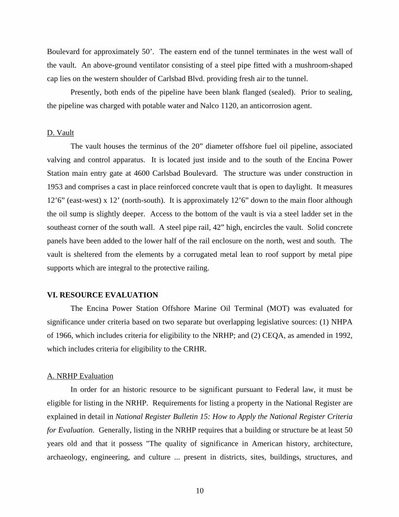
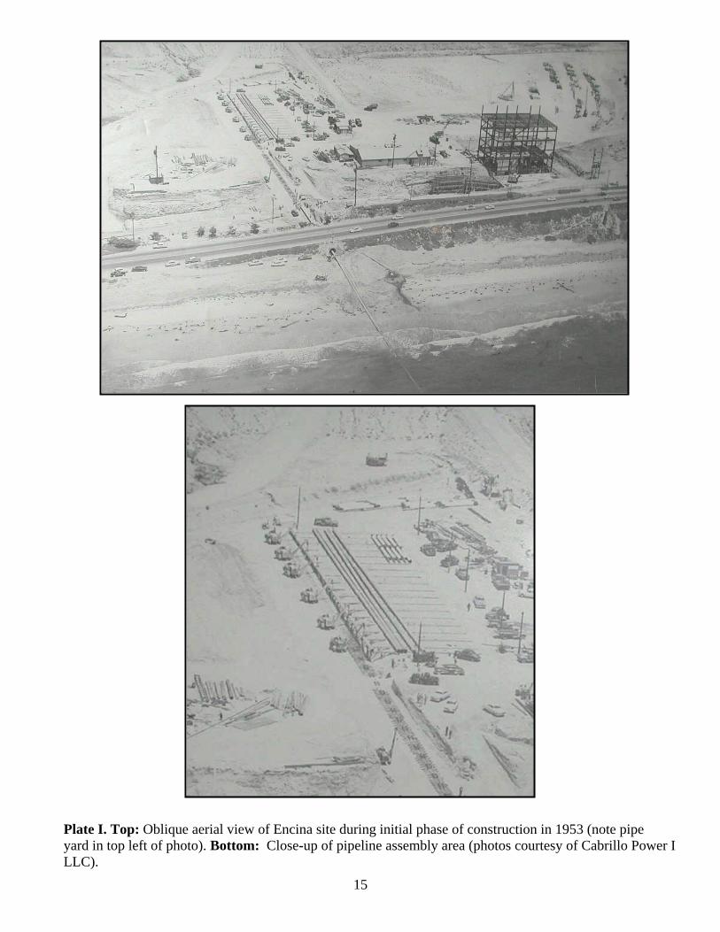
Plate I. Top: Oblique aerial view of Encina site during initial phase of construction in 1953 (note pipeyard in top left of photo). Bottom: Close-up of pipeline assembly area (photos courtesy of Cabrillo Power ILLC).
16
Plate I. Top: Westerly view of rip-rap jetty that protects pipeline as it emerges from the sea.Bottom: Westerly view of fresh air tunnel/vault vent located on west side of Carlsbad Boulevard.
17
Plate I. Top: Southwest view of vault located at the eastern terminus of the MOT pipeline.Bottom: Close-up of blank flanged sections of 20-inch pipeline located at the bottom of the vault.

Cabrillo Power I LLC Encina Marine Oil Terminal Decommissioning Project Revised Project Execution Plan
Blank Page

APPENDIX A:
DPR 523 Forms Package for Primary # 37-032953
Caltrans DPR 523B (11/94) Page 1 of 6*Required Information.
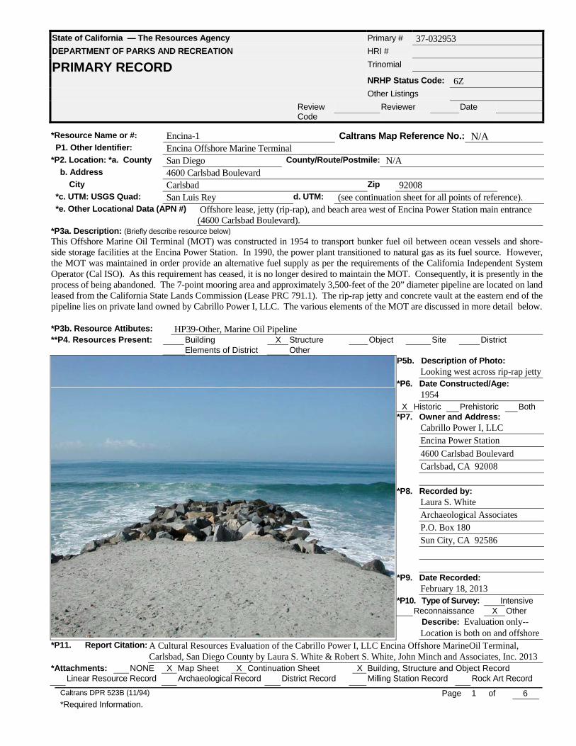
State of California — The Resources Agency Primary # 37-032953DEPARTMENT OF PARKS AND RECREATION HRI #
PRIMARY RECORD Trinomial
NRHP Status Code: 6ZOther Listings
ReviewCode
Reviewer Date
*Resource Name or #: Encina-1 Caltrans Map Reference No.: N/A P1. Other Identifier: Encina Offshore Marine Terminal*P2. Location: *a. County San Diego County/Route/Postmile: N/A b. Address 4600 Carlsbad Boulevard City Carlsbad Zip 92008 *c. UTM: USGS Quad: San Luis Rey d. UTM: (see continuation sheet for all points of reference). *e. Other Locational Data (APN #) Offshore lease, jetty (rip-rap), and beach area west of Encina Power Station main entrance
(4600 Carlsbad Boulevard).*P3a. Description: (Briefly describe resource below)
This Offshore Marine Oil Terminal (MOT) was constructed in 1954 to transport bunker fuel oil between ocean vessels and shore-side storage facilities at the Encina Power Station. In 1990, the power plant transitioned to natural gas as its fuel source. However,the MOT was maintained in order provide an alternative fuel supply as per the requirements of the California Independent SystemOperator (Cal ISO). As this requirement has ceased, it is no longer desired to maintain the MOT. Consequently, it is presently in theprocess of being abandoned. The 7-point mooring area and approximately 3,500-feet of the 20” diameter pipeline are located on landleased from the California State Lands Commission (Lease PRC 791.1). The rip-rap jetty and concrete vault at the eastern end of thepipeline lies on private land owned by Cabrillo Power I, LLC. The various elements of the MOT are discussed in more detail below.
*P3b. Resource Attibutes: HP39-Other, Marine Oil Pipeline**P4. Resources Present: Building X Structure Object Site District
Elements of District OtherP5b. Description of Photo:
Looking west across rip-rap jetty*P6. Date Constructed/Age:
1954X Historic Prehistoric Both
*P7. Owner and Address:Cabrillo Power I, LLCEncina Power Station4600 Carlsbad BoulevardCarlsbad, CA 92008
*P8. Recorded by:Laura S. WhiteArchaeological AssociatesP.O. Box 180Sun City, CA 92586
*P9. Date Recorded:February 18, 2013
*P10. Type of Survey: IntensiveReconnaissance X Other
Describe: Evaluation only--Location is both on and offshore
*P11. Report Citation: A Cultural Resources Evaluation of the Cabrillo Power I, LLC Encina Offshore MarineOil Terminal,Carlsbad, San Diego County by Laura S. White & Robert S. White, John Minch and Associates, Inc. 2013
*Attachments: NONE X Map Sheet X Continuation Sheet X Building, Structure and Object RecordLinear Resource Record Archaeological Record District Record Milling Station Record Rock Art Record
Caltrans DPR 523B (11/94) Page 2 of 6*Required Information
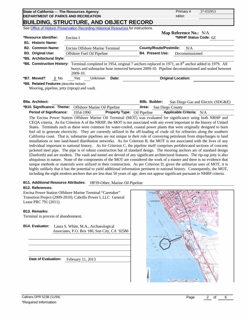
State of California ⎯ The Resources Agency: Primary # 37-032953DEPARTMENT OF PARKS AND RECREATION HRI#:
BUILDING, STRUCTURE, AND OBJECT RECORDSee Office of Historic Preservation Recording Historical Resources for instructions.
Map Reference No.: N/A*Resource Identifier: Encina-1 *NRHP Status Code: 6Z B1. Historic Name:
B2. Common Name: Encina Offshore Marine Terminal County/Route/Postmile: N/A B3. Original Use: Offshore Fuel Oil Pipeline B4. Present Use: Decommissioned*B5. Architectural Style:
*B6. Construction History: Terminal completed in 1954, original 7 anchors replaced in 1971, an 8th anchor added in 1979. Allbuoys and submarine hose removed between 2009-10. Pipeline decommissioned and sealed between2009-10.
*B7. Moved? X No Yes Unknown Date: Original Location:
*B8. Related Features (describe below):Mooring, pipeline, jetty (riprap) and vault.
B9a. Architect: B9b. Builder: San Diego Gas and Electric (SDG&E)*B10. Significance: Theme: Offshore Marine Oil Pipeline Area: San Diego County
Period of Significance: 1954-1990 Property Type: Oil Pipeline Applicable Criteria: N/AThe Encina Power Station Offshore Marine Oil Terminal (MOT) was evaluated for significance using both NRHP andCEQA criteria. As for Criterion A of the NRHP, the MOT is not associated with any event important in the history of UnitedStates. Terminals such as these were common for water-cooled, coastal power plants that were originally designed to burnfuel oil to generate electricity. They are currently utilized in the off-loading of crude oil for refineries along the southernCalifornia coast. That is, submarine pipelines are not unique in their role of conveying petroleum from ships/barges to landinstallations or into land-based distribution networks. As for Criterion B, the MOT is not associated with the lives of anyindividual important to national history. As for Criterion C, the pipeline itself comprises prefabricated sections of concretejacketed steel pipe. The pipe is of robust construction but of standard design. The mooring anchors are of standard design(Danforth) and are modern. The vault and tunnel are devoid of any significant architectural features. The rip-rap jetty is alsoubiquitous in nature. None of the components of the MOT are considered the work of a master and there is no evidence thatunique methods or materials were utilized in their construction. As per Criterion D, given the utilitarian uses of MOT, it ishighly unlikely that it has the potential to yield additional information pertinent to national history. Consequently, the MOT,including the eight modern anchors that are less than 50 years of age, does not appear significant pursuant to NHRP criteria.
B11. Additional Resource Attributes: HP39-Other, Marine Oil PipelineB12. References:Encina Power Station Offshore Marine Terminal “Caretaker”Transition Project (2009-2010), Cabrillo Power I, LLC GeneralLease PRC 791 (2011).
B13. Remarks:Terminal in process of abandonment.
B14. Evaluator: Laura S. White, M.A., ArchaeologicalAssociates, P.O. Box 180, Sun City, CA 92586
Date of Evaluation: February 11, 2013
Caltrans DPR 523L (12/94) Page 3 of 6
State of California ⎯ The Resources Agency Primary #: 37-032953DEPARTMENT OF PARKS AND RECREATION HRI #/Trinomial
CONTINUATION SHEET
See Office of Historic Preservation Recording Historical Resources for instructions. X Continuation Update
Caltrans Map Reference No.: N/AResource Identifier: Encina-1 County/Route/Postmile: N/A
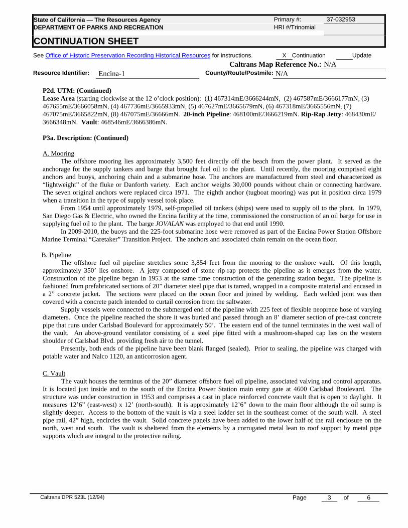
P2d. UTM: (Continued)Lease Area (starting clockwise at the 12 o’clock position): (1) 467314mE/3666244mN, (2) 467587mE/3666177mN, (3)467655mE/3666058mN, (4) 467736mE/3665933mN, (5) 467627mE/3665679mN, (6) 467318mE/3665556mN, (7)467075mE/3665822mN, (8) 467075mE/36666mN. 20-inch Pipeline: 468100mE/3666219mN. Rip-Rap Jetty: 468430mE/3666348mN. Vault: 468546mE/3666386mN.
P3a. Description: (Continued)
A. MooringThe offshore mooring lies approximately 3,500 feet directly off the beach from the power plant. It served as the
anchorage for the supply tankers and barge that brought fuel oil to the plant. Until recently, the mooring comprised eightanchors and buoys, anchoring chain and a submarine hose. The anchors are manufactured from steel and characterized as“lightweight” of the fluke or Danforth variety. Each anchor weighs 30,000 pounds without chain or connecting hardware.The seven original anchors were replaced circa 1971. The eighth anchor (tugboat mooring) was put in position circa 1979when a transition in the type of supply vessel took place.
From 1954 until approximately 1979, self-propelled oil tankers (ships) were used to supply oil to the plant. In 1979,San Diego Gas & Electric, who owned the Encina facility at the time, commissioned the construction of an oil barge for use insupplying fuel oil to the plant. The barge JOVALAN was employed to that end until 1990.
In 2009-2010, the buoys and the 225-foot submarine hose were removed as part of the Encina Power Station OffshoreMarine Terminal “Caretaker” Transition Project. The anchors and associated chain remain on the ocean floor.
B. PipelineThe offshore fuel oil pipeline stretches some 3,854 feet from the mooring to the onshore vault. Of this length,
approximately 350’ lies onshore. A jetty composed of stone rip-rap protects the pipeline as it emerges from the water.Construction of the pipeline began in 1953 at the same time construction of the generating station began. The pipeline isfashioned from prefabricated sections of 20” diameter steel pipe that is tarred, wrapped in a composite material and encased ina 2” concrete jacket. The sections were placed on the ocean floor and joined by welding. Each welded joint was thencovered with a concrete patch intended to curtail corrosion from the saltwater.
Supply vessels were connected to the submerged end of the pipeline with 225 feet of flexible neoprene hose of varyingdiameters. Once the pipeline reached the shore it was buried and passed through an 8’ diameter section of pre-cast concretepipe that runs under Carlsbad Boulevard for approximately 50’. The eastern end of the tunnel terminates in the west wall ofthe vault. An above-ground ventilator consisting of a steel pipe fitted with a mushroom-shaped cap lies on the westernshoulder of Carlsbad Blvd. providing fresh air to the tunnel.
Presently, both ends of the pipeline have been blank flanged (sealed). Prior to sealing, the pipeline was charged withpotable water and Nalco 1120, an anticorrosion agent.
C. VaultThe vault houses the terminus of the 20” diameter offshore fuel oil pipeline, associated valving and control apparatus.
It is located just inside and to the south of the Encina Power Station main entry gate at 4600 Carlsbad Boulevard. Thestructure was under construction in 1953 and comprises a cast in place reinforced concrete vault that is open to daylight. Itmeasures 12’6” (east-west) x 12’ (north-south). It is approximately 12’6” down to the main floor although the oil sump isslightly deeper. Access to the bottom of the vault is via a steel ladder set in the southeast corner of the south wall. A steelpipe rail, 42” high, encircles the vault. Solid concrete panels have been added to the lower half of the rail enclosure on thenorth, west and south. The vault is sheltered from the elements by a corrugated metal lean to roof support by metal pipesupports which are integral to the protective railing.

Caltrans DPR 523L (12/94) Page 4 of 6
State of California ⎯ The Resources Agency Primary #: 37-032953DEPARTMENT OF PARKS AND RECREATION HRI #/Trinomial
CONTINUATION SHEET
See Office of Historic Preservation Recording Historical Resources for instructions. X Continuation Update
Caltrans Map Reference No.: N/AResource Identifier: Encina-1 County/Route/Postmile: N/A
B.12: Significance (Continued)In applying Criterion 1 of the CRHR, the MOT is not associated with any event important in the local/regional history ofCalifornia. It is not the only MOT in the region. In particular, Cheveron maintains a MOT just off El Segundo for itssprawling refinery as does Southern California Edison for its Mandalay Generating Station in Goleta. No unique uses otherthan conveying fuel oil to the Encina site have been identified with the MOT. Per Criterion 2, the MOT is not associatedwith the lives of any individual important to local or California history. In the application of Criterion 3, it is to be notedthat the concrete over steel pipe sections of pipeline were well designed and built to withstand the ravages of time.However, they were prefabricated at a factory off-site and are of standard design. None of the components of the MOTexhibit any unique architectural or design features. That is, they were designed and constructed to be purely utilitarian indesign and function. The MOT is not considered the work of a master and there is no evidence that unique methods ormaterials were utilized its construction. Per Criterion 4, given the utilitarian uses of the MOT, it is highly unlikely that itwill have the potential to yield any additional information pertinent to the history of the local area or the State of California.Consequently, the MOT, including the eight modern anchors that are less than 50 years of age, does not appear significantpursuant to CRHR criteria.
Northwesterly view of pipeline vault located immediately south of main entrance on Carlsbad Boulevard.
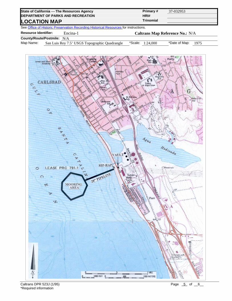
Caltrans DPR 523J (1/95) Page 5 of __6__*Required information
State of California ⎯ The Resources Agency Primary # 37-032953DEPARTMENT OF PARKS AND RECREATION HRI#
LOCATION MAP Trinomial
See Office of Historic Preservation Recording Historical Resources for instructions.
Resource Identifier: Encina-1 Caltrans Map Reference No.: N/ACounty/Route/Postmile: N/AMap Name: San Luis Rey 7.5’ USGS Topographic Quadrangle *Scale: 1:24,000 *Date of Map: 1975
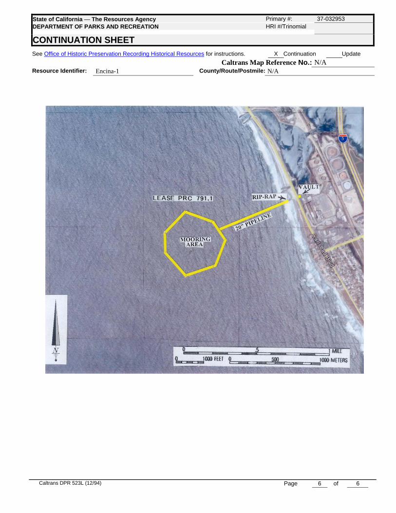
Caltrans DPR 523L (12/94) Page 6 of 6
State of California ⎯ The Resources Agency Primary #: 37-032953DEPARTMENT OF PARKS AND RECREATION HRI #/Trinomial
CONTINUATION SHEET
See Office of Historic Preservation Recording Historical Resources for instructions. X Continuation Update
Caltrans Map Reference No.: N/AResource Identifier: Encina-1 County/Route/Postmile: N/A
STATE OF CALIFORNIA EDMUND G. BROWN JR., Governor
October 2, 2015 File Ref: W30068.1
«CompanyOrg» «First» «Last»«Title» «Address» «City», «State» «Zip»
Subject: Notification of the Cabrillo Power I LLC Encina Marine Oil Terminal Decommissioning Project
Dear Mr./Ms. «Last»:
California State Lands Commission (CSLC) staff is providing this letter to notify you of the proposed Cabrillo Power I LLC Encina Marine Oil Terminal Decommissioning Project (Project), for which we are preparing a Mitigated Negative Declaration (MND). A new California law known as “Assembly Bill (AB) 52” (Chapter 532, Statutes of 2014) effective on July 1, 2015, makes changes to the California Environmental Quality Act (CEQA) regarding tribal cultural resources and consultation with California Native American Tribes who have previously requested to be notified of projects in the geographic area traditionally and culturally affiliated with that tribe. While we have no written requests from any tribes for the area associated with this Project, we wish to engage with tribes proactively to ensure you have the opportunity to provide meaningful input on the Project’s potential effects. You will also receive a separate notice when the MND is released for a 30-day public review and comment period.
The proposed Project involves the decommissioning of existing, non-operational infrastructure, and does not include the development of any new structures (please review the proposed Project components, described below). Conejo Archaeological Consultants sent notification of the Project on January 20, 2013, to a list of Native American representatives provided by the Native American Heritage Commission (NAHC). Information collected and investigations conducted for the MND analysis indicate that there are two archaeological sites within 0.25 mile of the Project site; however, a Sacred Lands File search conducted by the NAHC did not identify Native American traditional cultural places or properties within 0.5 mile of the Project’s infrastructure. The NAHC did note that the Project site is located 5 miles north of a known underwater village, which is considered California State Parks land off Cardiff State Beach, and that the area around the Agua Hedionda Lagoon to the north of the Project site is considered very culturally sensitive.
CALIFORNIA STATE LANDS COMMISSION
EXECUTIVE OFFICE 100 Howe Avenue, Suite 100-South
Sacramento, CA 95825-8202
JENNIFER LUCCHESI, Executive Officer (916) 574-1800 Fax (916) 574-1810
California Relay Service TDD Phone 1-800-735-2929 Voice Phone 1-800-735-2922
«First» «Last» Page 2 October 2, 2015
If you have any questions, or wish to discuss the Project, please contact Jennifer DeLeon at [email protected], or at (916) 574-0748. CSLC staff also encourages you to visit the NAHC’s AB 52 resource page at http://nahc.ca.gov/codes/, where you can find a sample letter requesting notification of future CEQA projects, along with other information. The Project is located in and offshore of the City of Carlsbad, San Diego County. The address of the Encina Power Station (EPS), which houses the onshore components of the Encina Marine Oil Terminal (MOT), is 4600 Carlsbad Boulevard, Carlsbad, California 92008. The Project involves the decommissioning of the existing non-operational MOT, including the removal of an approximately 3,855-foot fuel oil submarine pipeline. The fuel oil submarine pipeline originates in the EPS, crossing Carlsbad Boulevard and Carlsbad State Beach below ground, and terminates offshore in approximately 60 feet of water. The Project, in summary, is comprised of the following decommissioning elements:
1. Removal of the entire fuel oil submarine pipeline; 2. Decommissioning of the onshore EPS, including the beach valve pit, underpass
conduit, underpass end structure, and all associated electrical and piping components;
3. Temporary removal of the riprap groin on Carlsbad State Beach and restoration of the groin after the underlying fuel oil submarine pipeline has been removed;
4. Restoration of the beach; 5. Removal of several components of the offshore MOT, including two end anchors
and a termination marker buoy at the offshore terminus of the fuel oil submarine pipeline, a navigation buoy, a seven-point mooring system, and a single-point mooring;
6. Removal of all seafloor debris associated with the MOT operations; and 7. Quit claim of the remaining portions of the underpass to the City of Carlsbad.
Onsite decommissioning activities are currently scheduled to begin in September 2016 and completed in January 2018. Again, if you have any questions, please feel free to contact me or my tribal liaison at your convenience. You may also contact the Project staff lead, Kelly Keen, by phone at (916) 574-1938 or via email at [email protected]. Sincerely, JENNIFER LUCCHESI Executive Officer
«First» «Last» Page 3 October 2, 2015
Enclosures: 1. Project Site Location 2. Onshore Project Components 3. Offshore Project Components cc: K. Keen J. DeLeon P. Griggs K. Colson Identical Letters Sent To: Barona Group of the Captain Grande California Native American Heritage Commission Ipay Nation of Santa Ysabel Kumeyaay Cultural Repatriation Committee Kwaaymii Laguna Band of Mission Indians Mesa Grande Band of Mission Indians Office of Historic Preservation Pala Band of Mission Indians, Historic Preservation Office Pauma & Yuima Reservation Pechanga Band of Mission Indians Rincon Band of Luiseño Indians Rincon Band of Mission Indians, Chairperson Rincon Band of Mission Indians, Tribal Historic Preservation Officer San Luis Rey Band of Mission Indians San Pasqual Band of Mission Indians, Chairperson San Pasqual Band of Indians, Environmental Coordinator
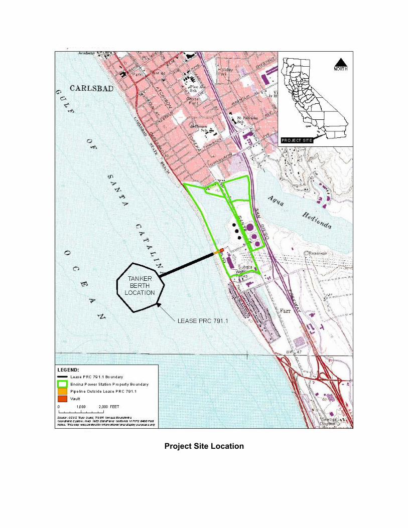
Project Site Location
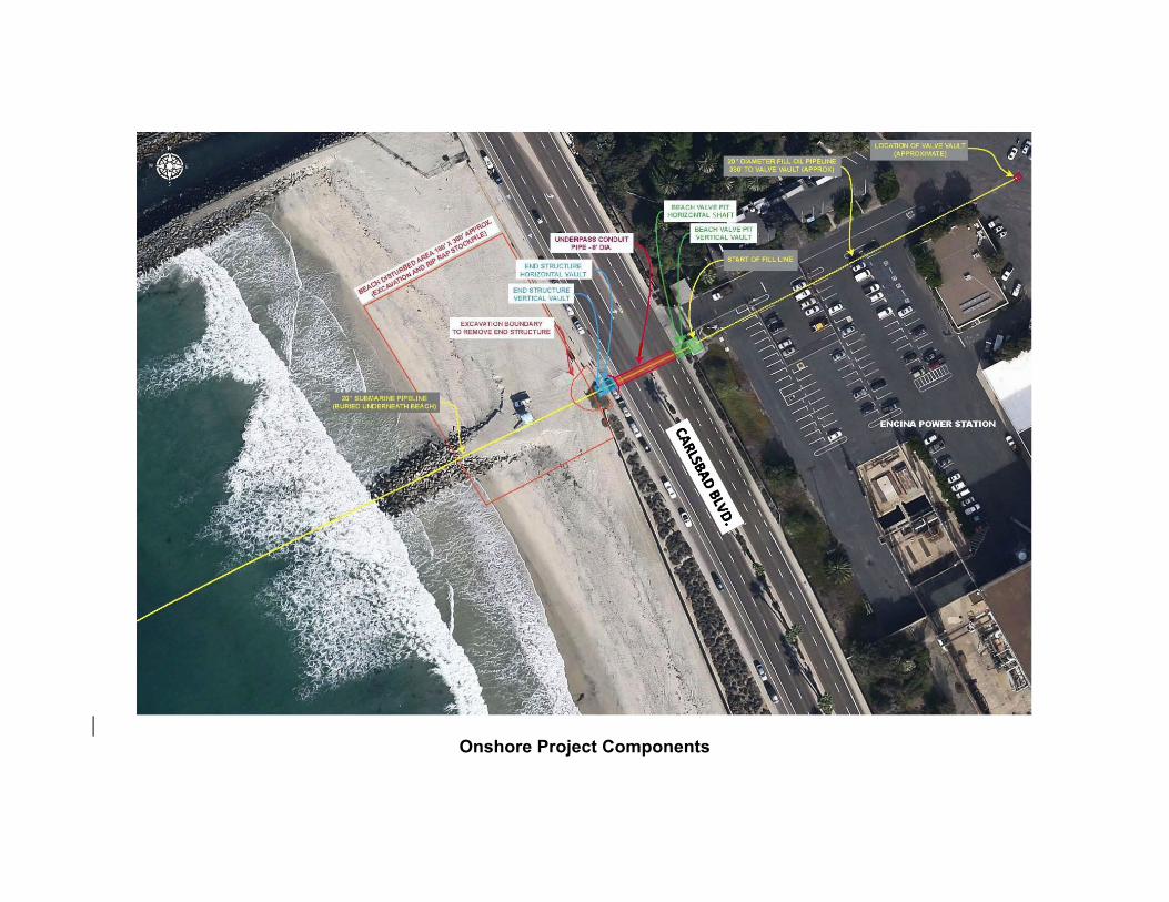
Onshore Project Components
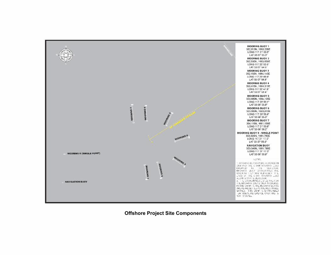
Offshore Project Site Components