appendix f wildlife report - deq.state.wy.us documents/surface...appendix f wildlife report ... mule...
TRANSCRIPT
Appendix F Wildlife Report
Salt Creek Use Attainability Analysis Salt Creek, Natrona County and Johnson County, Wyoming
Prepared by:
The RETEC Group, Inc. 2409 Research Blvd., Suite 106 Fort Collins, Colorado 80526
RETEC Project Number: APC02-18086-460
Prepared for:
Anadarko Petroleum Corporation P.O. Box 10 Midwest, Wyoming 82643
Prepared by:
____________________________________________ Ken Pinnella, Toxicologist
Reviewed by:
____________________________________________ Bjorn Bjorkman, Senior Scientist
October 25, 2004
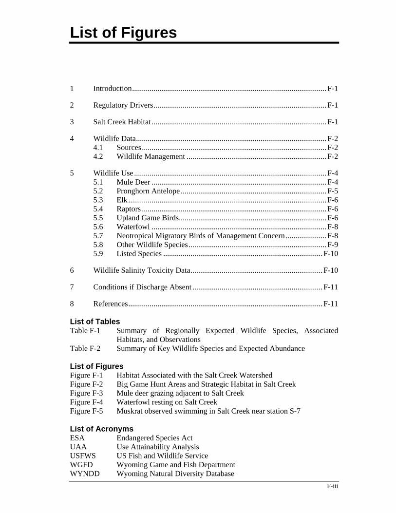
List of Figures
F-iii
1 Introduction....................................................................................................F-1
2 Regulatory Drivers.........................................................................................F-1
3 Salt Creek Habitat ..........................................................................................F-1
4 Wildlife Data..................................................................................................F-2 4.1 Sources...............................................................................................F-2 4.2 Wildlife Management ........................................................................F-2
5 Wildlife Use ...................................................................................................F-4 5.1 Mule Deer ..........................................................................................F-4 5.2 Pronghorn Antelope ...........................................................................F-5 5.3 Elk ......................................................................................................F-6 5.4 Raptors ...............................................................................................F-6 5.5 Upland Game Birds............................................................................F-6 5.6 Waterfowl ..........................................................................................F-8 5.7 Neotropical Migratory Birds of Management Concern .....................F-8 5.8 Other Wildlife Species.......................................................................F-9 5.9 Listed Species ..................................................................................F-10
6 Wildlife Salinity Toxicity Data....................................................................F-10
7 Conditions if Discharge Absent ...................................................................F-11
8 References....................................................................................................F-11 List of Tables Table F-1 Summary of Regionally Expected Wildlife Species, Associated
Habitats, and Observations Table F-2 Summary of Key Wildlife Species and Expected Abundance List of Figures Figure F-1 Habitat Associated with the Salt Creek Watershed Figure F-2 Big Game Hunt Areas and Strategic Habitat in Salt Creek Figure F-3 Mule deer grazing adjacent to Salt Creek Figure F-4 Waterfowl resting on Salt Creek Figure F-5 Muskrat observed swimming in Salt Creek near station S-7 List of Acronyms ESA Endangered Species Act UAA Use Attainability Analysis USFWS US Fish and Wildlife Service WGFD Wyoming Game and Fish Department WYNDD Wyoming Natural Diversity Database
Appendix F – Wildlife Report
F-1
1 Introduction This report evaluates available data on wildlife species that occur or are likely to occur in the area of Salt Creek and the Powder River immediately downstream of its confluence with Salt Creek. The study area is depicted in Figure F-1. Both game and non-game wildlife species are known to be present in association with Salt Creek. The goal of this evaluation is to support the Use Attainability Analysis (UAA) by determining the effect on regional wildlife from altering current Salt Creek (produced water) conditions. To this end, this evaluation will qualitatively and quantitatively assess the presence of species that occur in the study area under current conditions; review the ecological resources and habitats present that support these species under current conditions; evaluate the potential effect on future populations should the produced water of the Salt Creek watershed be diminished or eliminated; and evaluate the tolerance of wildlife species to elevated chloride levels in Salt Creek water.
2 Regulatory Drivers Wildlife beneficial use includes protection of water quality to a level that is safe for contact and consumption by avian and terrestrial wildlife species. It is a designated use for all waters of the State (Section 3(h) of Chapter 1 of the Water Quality Rules and Regulations) (WDEQ, 2001).
Wyoming does not provide numeric criteria for this use. A water of the State is considered to be partially supporting or not supporting this use if any pollutant can be demonstrated to cause exceedance of one or more narrative water quality standards as it pertains to wildlife (WDEQ, 2002). To make this determination, specific water quality data is reviewed in conjunction with literature data on wildlife health or on information on injury to wildlife reported by wildlife agencies. For this UAA, the wildlife use of Salt Creek is described and the chloride data on Salt Creek is compared to chloride tolerance data found in the literature.
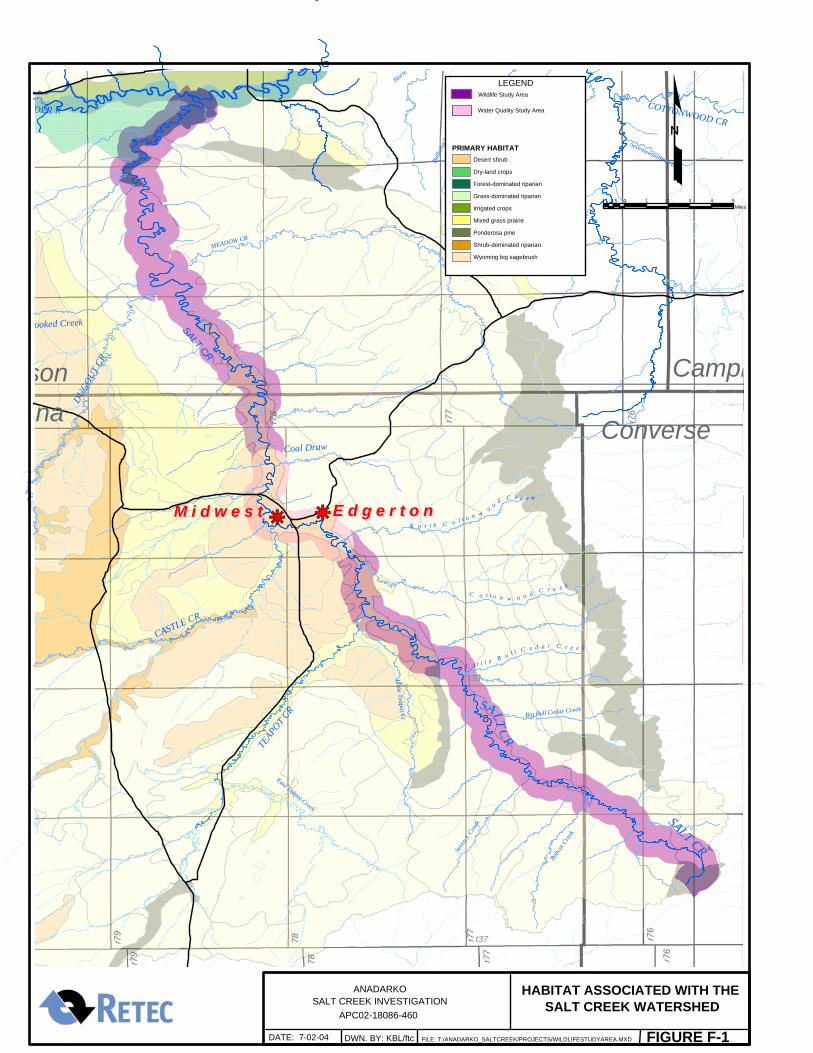
3 Salt Creek Habitat Salt Creek flows through a mosaic of habitat types within the study area, as depicted in Figure F-1. Wyoming Game and Fish Department (WGFD) land cover classifications and GAP Analysis Project mapping were used to define terrestrial vegetation and land cover types (Figure F-1). The habitats directly associated with or adjacent to Salt Creek include mixed grass prairie, Wyoming big sagebrush, desert shrub, forest-dominated riparian, and dry land crops. Other vegetative land cover types exist within the study area, but do not occur adjacent to Salt Creek. These include shrub-dominated riparian (on hillsides in the western end of the watershed), ponderosa pine (along Pine
Appendix F – Wildlife Report
F-2
Ridge to the east of the watershed), and irrigated cropland and grass-dominated riparian areas (north of the Upper Powder River). In addition, Salt Creek proper, and associated wetlands provides habitat for wildlife and birds. Wetland areas are described in detail in Appendix C (Wetlands Report).
The vegetation types listed above provide habitat and resources to a variety terrestrial and riparian wildlife that are common to the area. It is expected that many wildlife species utilize resources from more than one habitat type due to the mosaic of associated habitats that occur within the study area. Wildlife species that are expected to occur regionally in these habitats are included in Table F-1.
4 Wildlife Data 4.1 Sources
Available data on wildlife were derived from the following principal sources. Numeric data from WGFD and the Wyoming Natural Diversity Database (WYNDD) is considered quantitative and credible. Other data is qualitative.
• Wyoming Natural Diversity Database (WYNDD, 2004) – study area-specific information on occurrence of sensitive species (i.e., federal or state listed species) in graphical and tabular form.
• Powder River Final EIS (BLM, 2003) – information on census and hunting reports for game species during 2000 season and general information regarding species occurrences.
• Wyoming Game and Fish Department (WGFD) – the WGFD web site and other resources were consulted to obtain supplemental census and hunting data, lek location information, 2002 hunting and census data, and other pertinent data.
• Self-reporting by area ranchers as part of Appendix G (Livestock Report)
• Casual observations by RETEC and AATA field staff during field surveys
4.2 Wildlife Management Local, state or federal administered wildlife areas including refuges, reserves, preserves, wetlands, and lands otherwise designated for wildlife habitat and/or use was reviewed to determine whether any occur within the Salt Creek study area. State administered areas include wildlife habitat management areas (WHMAs), strategic habitat areas, and hunt areas. Federal administered areas include areas containing critical habitat such as wetlands and areas known to
Appendix F – Wildlife Report
F-3
attract (for feeding, resting or breeding) rare and endangered species, managed under the US Fish and Wildlife Service (USFWS), and other important and sensitive habitats.
• Wildlife Habitat Management Areas
Wildlife habitat management areas are areas maintained by WGFD to provide critical winter habitat, important production areas, and important staging and feeding habitat for game and non-game wildlife species. No WHMAs are present in the Salt Creek watershed.
• Strategic Habitat Areas
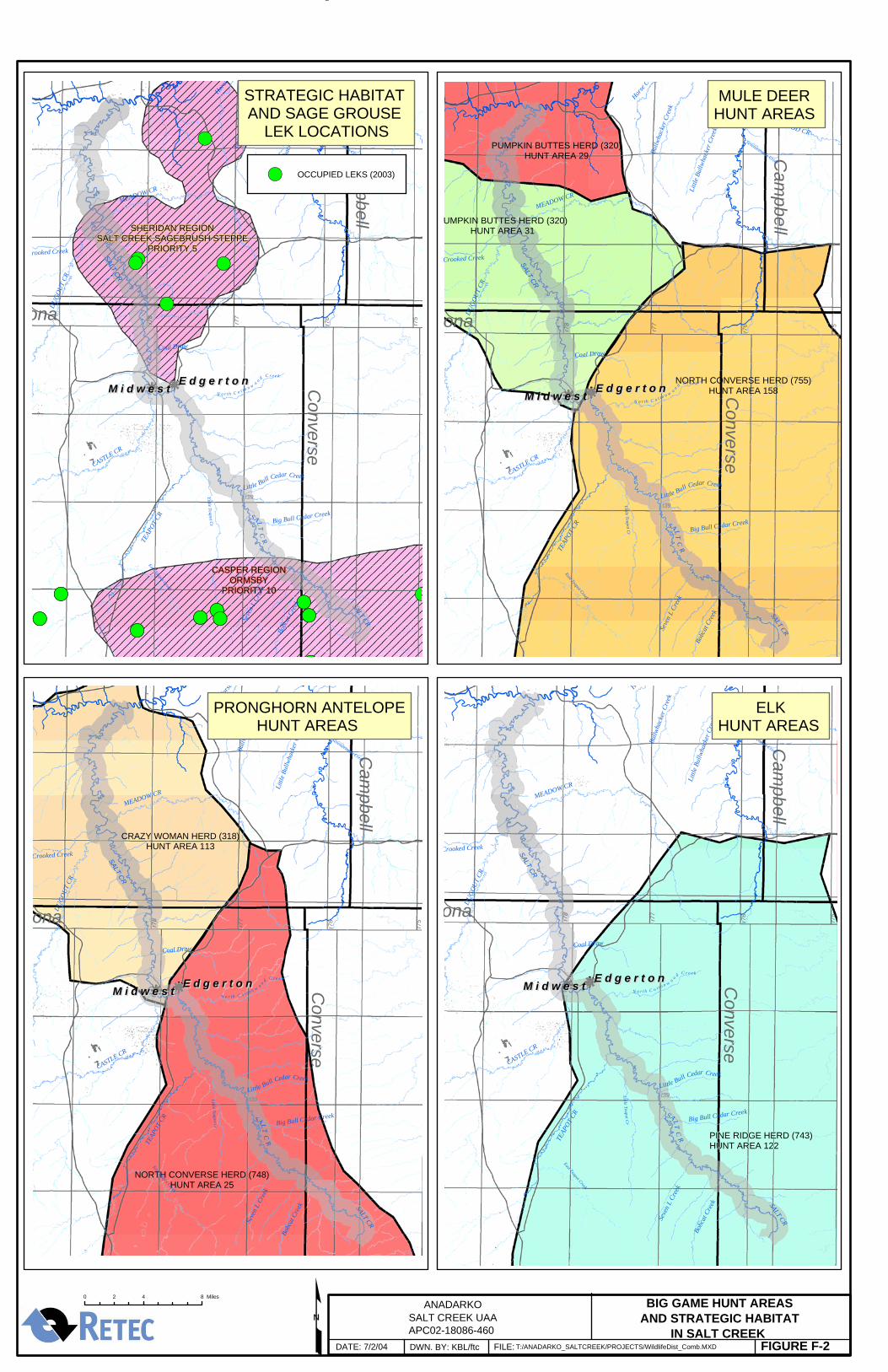
In an effort to conserve habitats and wildlife WGFD has prepared a Strategic Habitat Plan (WGFD, 2001). The scope of the plan is to manage and/or restore habitat to sustain wildlife populations under current and future conditions. WGFD has defined two strategic habitat areas in the Salt Creek area (Figure F-2): Sheridan Region Salt Creek Sagebrush Steppe (priority number 5) and the Ormsby area (Casper Region priority number 10). These areas correspond to primarily upland habitats and are not specifically dependent on Salt Creek.
• Hunt Areas
The Salt Creek watershed falls within big game (i.e., antelope, deer and elk) hunt areas and small and upland game management areas. These areas may occur on private and/or state or federal land. Hunt areas do not affect Salt Creek habitat.
• Critical Habitat
The US Fish and Wildlife Service (USFWS) administer habitat or natural features that serve as essential areas for threatened and endangered species under the Endangered Species Act (ESA). No critical habitat for a listed species has been identified in the study area.
• Sensitive Habitat
The Wyoming Department of Environmental Quality (WDEQ) has defined sensitive habitat as local, state or federally administered natural areas including wetlands, refuges and preserves, habitat restoration areas, lands designated for wildlife habitat or use, and unique or rare habitat (e.g., thermal springs) (WDEQ, 2004). Some wetland areas occur in association with Salt Creek (see Appendix C, Wetland Report) but no other sensitive habitat areas are present.
Appendix F – Wildlife Report
F-4
5 Wildlife Use The Salt Creek corridor provides important habitat to a variety of wildlife species: both upland and riparian habitat are important for food, shelter, and water resources. The natural (native) habitat in this area has been impacted by historical oil and gas development and production, agriculture, livestock use, and other land uses. Local topography includes small canyons and breaks, rocky outcrops, cliffs, and small rocky hills, all of which provide important habitat for wildlife. The following subsections provide information on wildlife observations made in the study area by landowners and project biologists, summarizes current wildlife use, and identifies key species.
Observations of wildlife using the habitats in and around the Salt Creek corridor were compiled from project biologists as well as local landowners (see Appendix G, Livestock Report). Observed wildlife is tabulated in Table F-1 and includes ungulates (mule deer, pronghorn antelope, and elk), carnivores (coyotes), small mammals (rabbit), upland birds (chukar, gray partridge, sage grouse), raptors (eagles – species not specified), and waterfowl (cranes, ducks and geese – species not specified). Additional qualitative observations made by project biologists, during field visits, include mule deer and pronghorn antelope, cottontail rabbit, beaver, red fox, and passerine and non-passerine birds (e.g., red-tailed hawk, ring-necked pheasant, sandhill crane). The degree of dependence of wildlife species on Salt Creek for critical habitat and resources varies. A few commercially or ecologically significant species are discussed in greater detail in the following sections.
5.1 Mule Deer Mule deer are common in the Salt Creek area (Figure F-3). Two primary mule deer herd units identified by WGFD occupy the Salt Creek study area either entirely or partially and include the Pumpkin Buttes herd unit (320) and the North Converse herd unit (755) (Figure F-2). The overall population of these herds is approximately 21,557 animals (WGFD, 2004a). The range of herd 759 (North Natrona) abuts the western extent of the Salt Creek study area but overlaps only a small fraction of the Salt Creek watershed and is not considered in the population estimate. Based on herds 320 and 755, a total harvest of 1,656 animals was recorded for the 2002 mule deer hunting season (WGFD, 2002a). The Ormsby (hunt area 158), Johnson (hunt area 29), and Salt Creek (hunt area 31) mule deer hunt areas encompass parts of the Salt Creek basin (Figure F-2). A total of 877 animals were harvested in these areas in the 2002 hunting season (WGFD, 2002a).
The seasonal distribution of mule deer was reviewed based on 2000 data (BLM, 2003). Although the ranges are subject to change the 2000 season is thought adequately representative of current conditions. BLM (2003) reports that the mule deer range in the Salt Creek watershed includes a total year-round range of approximately 114,819 acres. Sixty-two percent (71,511 acres)
Appendix F – Wildlife Report
F-5
of this range is also occupied by winter populations, indicating a significant influx of additional animals into the area during winter months.
Mule deer use of Salt Creek occurs in all areas of upland and riparian habitats. Mule deer persist on a wide-range of vegetation consisting of shrubs, grasses, and forbs and make use of Salt Creek corridor topography (canyons and breaks) for access to and from upland and riparian areas as well as for browse and shelter. Mule deer foraging ranges range up to 5400 acres (Fitzgerald, 1994). Mule deer are generally thought to require good quality water for drinking. Salt Creek is likely to provide a critical water source for the resident herd(s), particularly in summer when other sources are dry or undrinkable, and during critical winter foraging when moisture (snow) is absent.
5.2 Pronghorn Antelope Pronghorn antelope occur throughout Wyoming but are most abundant in short and mixed grass habitats and open sagebrush steppe ecosystems. This species is very common in the Salt Creek corridor. It persists on a diet of primarily shrubs and forbs. Typical daily movement of pronghorn does not exceed 10 kilometers, but territory size ranges up to 5.2 km2 or 1300 acres.
The seasonal distribution of pronghorn based on watershed, surface cover and land ownership was reviewed in BLM (2003), based on 2000 data. Although the ranges are subject to change based on current management data the 2000 season is thought adequately representative of current conditions. Per BLM (2003), the distribution of pronghorn along the Salt Creek watershed includes a total range of approximately 139,825 acres of which the antelope population, or a portion thereof, makes use of the associated habitat within the range on a year-round basis. A portion of the population (about 13%) uses this watershed seasonally, using the habitats within the range during spring, summer and fall but over-wintering outside this range, while winter-yearlong populations (indicating a significant influx of additional animals into the area from other areas during winter months) occupy another 13%. Seventy-four percent of the population is resident in the area.
The Crazy Woman (318) and North Converse (748) herd units occupy the study area either entirely or partially (Figure F-2). The overall population of these herd units is approximately 32,460 animals (WGFD, 2004a). A total of 708 animals corresponding to these herds were harvested during the 2002 hunting season. The primary hunt areas corresponding to these herds include the Salt Creek (113) and Ormsby (25) hunt areas, where 198 and 510 animals were harvested during the 2002 hunting season, respectively (WGFD, 2002b).
Antelope are wide-ranging and generally quite tolerant to changes in water availability and quality (Deblinger, 1988). Although specific needs for reliable water sources may be more pronounced for younger animals or lactating females, Deblinger demonstrated that with the removal of a primary water source, no major distribution shifts were noted. Thus pronghorn in the Salt
Appendix F – Wildlife Report
F-6
Creek corridor are not expected to be dependent on Salt Creek for water resources.
5.3 Elk Elk are uncommon in the Salt Creek corridor due to lack of suitable habitat but have been observed by local ranchers in upland areas associated with the upper portions of Salt Creek. These animals are likely migrants from nearby Pine Ridge.
Only one herd unit occupies the study area either entirely or partially (i.e., Pine Ridge herd unit 743) (Figure F-2). This herd is largely concentrated in the coniferous forests associated with Pine Ridge, to the east of Salt Creek. While some occurrences of elk in the Salt Creek watershed may occur, these are uncommon (personal communication between Reg Rothwell, WGFD and Ken Pinnella, RETEC). Elk are not expected to be associated with or dependent upon Salt Creek for resources.
5.4 Raptors Many raptor species occur through out the region and a number are expected to occur in appropriate habitats in the Salt Creek corridor. According to the study conducted by BLM, common species in the area include the golden eagle, American kestrel, Swainson’s hawk, ferruginous hawk, prairie falcon, short-eared owl, and great horned owl (BLM, 2003). Less common species include the bald eagle, rough-legged hawk, osprey, merlin, and burrowing owl. While some raptors may use habitat associated with Salt Creek, due to relatively large foraging ranges and low occurrence of water dependent species, raptors are not likely dependent on Salt Creek water resources.
5.5 Upland Game Birds Several species of upland game birds occur throughout the region and are likely to occur in upland areas associated with Salt Creek. Common game birds for the area based on observation by AATA and local ranchers and expected ranges include the sage grouse (Centrocercus urophasianus), sharp-tailed grouse (Pediocetes phansianellus) gray partridge (Perdix perdix), chukar partridge (Alectoris chukar), ring-necked pheasant (Phasianus colchicus), and Merriam’s turkey (Meleagris gallopavo) (Luce et al., 1997 and WGFD, 2004b).
Upland birds (and waterfowl and small game) are not extensively managed. Consequently, hunt areas are considerably larger and less defined (e.g., sharp-tailed grouse have a single hunt area (Area 1) - located east of the continental divide), and so records of hunting take are not readily available and estimates of populations of upland birds is not possible. Locations of lek sites, areas were mating “dances” are performed by male birds, were identified for upland
Appendix F – Wildlife Report
F-7
species (i.e., sage grouse) to determine if any occur in association with the Salt Creek corridor. Key species are discussed below.
• Sage Grouse
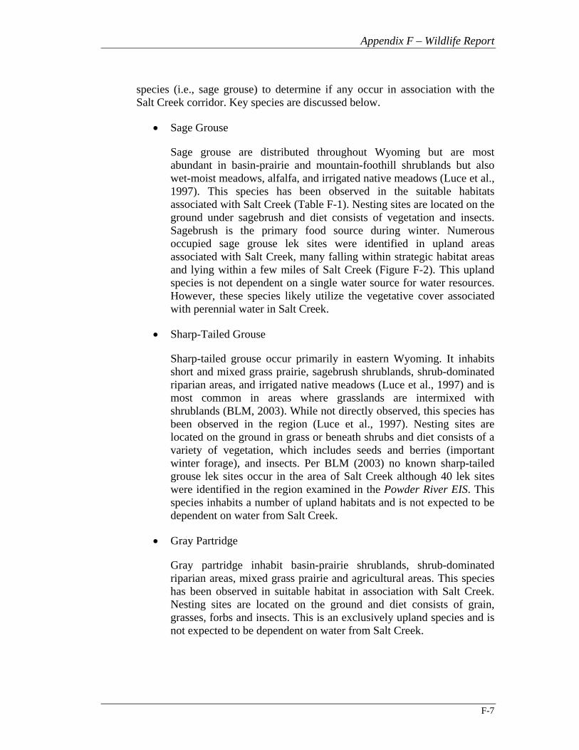
Sage grouse are distributed throughout Wyoming but are most abundant in basin-prairie and mountain-foothill shrublands but also wet-moist meadows, alfalfa, and irrigated native meadows (Luce et al., 1997). This species has been observed in the suitable habitats associated with Salt Creek (Table F-1). Nesting sites are located on the ground under sagebrush and diet consists of vegetation and insects. Sagebrush is the primary food source during winter. Numerous occupied sage grouse lek sites were identified in upland areas associated with Salt Creek, many falling within strategic habitat areas and lying within a few miles of Salt Creek (Figure F-2). This upland species is not dependent on a single water source for water resources. However, these species likely utilize the vegetative cover associated with perennial water in Salt Creek.
• Sharp-Tailed Grouse
Sharp-tailed grouse occur primarily in eastern Wyoming. It inhabits short and mixed grass prairie, sagebrush shrublands, shrub-dominated riparian areas, and irrigated native meadows (Luce et al., 1997) and is most common in areas where grasslands are intermixed with shrublands (BLM, 2003). While not directly observed, this species has been observed in the region (Luce et al., 1997). Nesting sites are located on the ground in grass or beneath shrubs and diet consists of a variety of vegetation, which includes seeds and berries (important winter forage), and insects. Per BLM (2003) no known sharp-tailed grouse lek sites occur in the area of Salt Creek although 40 lek sites were identified in the region examined in the Powder River EIS. This species inhabits a number of upland habitats and is not expected to be dependent on water from Salt Creek.
• Gray Partridge
Gray partridge inhabit basin-prairie shrublands, shrub-dominated riparian areas, mixed grass prairie and agricultural areas. This species has been observed in suitable habitat in association with Salt Creek. Nesting sites are located on the ground and diet consists of grain, grasses, forbs and insects. This is an exclusively upland species and is not expected to be dependent on water from Salt Creek.
Appendix F – Wildlife Report
F-8
• Chukar
Chukar partridge occur primarily through the central portion of Wyoming. It inhabits mountain-foothill desert shrubland habitat. This species has been observed in suitable upland habitat in association with Salt Creek. Nesting sites are located on the ground among rocks and/or shrubs and diet consists of seeds, leaves, and insects. This is an upland species and is not expected to be dependent on water from Salt Creek.
• Ring-necked Pheasant
Ring-necked pheasant inhabit forest-dominated (cottonwood) and shrub-dominated riparian areas, sedge meadows, and agricultural areas (Luce et al., 1997). This species has been observed in suitable habitat in association with Salt Creek by both AATA biologists and local ranchers (see Appendix G, Livestock Study). Nesting sites are located on the ground among grasses or weeds and diet consists of a variety of vegetation, insects and animals. Pheasant depend on brushy cover associated with perennial water sources for habitat and forage. Dependence on Salt Creek water is likely.
5.6 Waterfowl Salt Creek and the Powder River may serve as important stopover habitats for migrating waterfowl in the spring and fall and serve as important staging and breeding habitats during summer (Figure F-4). Salt Creek is in a region that lies at the western edge of the central flyway or migratory route and may serve as an important stopover area for waterfowl. Observations by local ranchers confirm that large numbers of ducks, geese and other waterfowl (e.g., herons) use Salt Creek seasonally, especially in fall, and during periods of inclement whether. The occurrence and distribution of these species may vary by local conditions such as climate (e.g., drought), land use, season, and adjacent upland habitat (BLM, 2003). The presence of waterfowl is entirely dependent on the availability of perennial water in Salt Creek.
AATA biologists observed five species of waterfowl during June and July of 2003: great blue heron, Canada goose, mallard, northern pintail, and blue-winged teal. These and other waterfowl expected to occur in the area are summarized in Table F-1.
5.7 Neotropical Migratory Birds of Management Concern The BLM has identified a wide variety of neotropical migrants that may use all or part of the study region, including the Salt Creek corridor, for breeding or during migration (BLM, 2003). The BLM study notes that shrub-steppe
Appendix F – Wildlife Report
F-9
habitats and short grass prairie habitats common to the area are critical habitat types to some migrants, as many species of management concern use these habitats as primary breeding areas.
The Wyoming Bird Conservation Plan (Cerovski et al., 2001) identifies two categories of high priority neotropical migrant species that are of management concern in Wyoming, Level I and Level II species. Level I species are those migrant species in need of active conservation, while Level II species are those requiring monitoring efforts. Regionally significant Level I and Level II species with habitat requirements consistent with Salt Creek and surrounding area are tabulated in Table F-1. Of the species listed in Table F-1 the following species have been observed using Salt Creek and associated habitats (AATA observations): Wilson’s pharlope (Level I) and lark bunting (Level II). Quantitative estimates of migratory birds are not available (BLM, 2003), although Breeding Bird Survey data per Sauer et al. (2001) were compiled and evaluated by BLM to determine population trends in Wyoming and the United States (increasing or decreasing trend). The appropriate trend analysis for these observed bird species is included in Table F-2. Wilson’s pharlope is an aquatic bird species that is dependent on reliable water flow in Salt Creek.
5.8 Other Wildlife Species Other wildlife species include small game and other small nongame species. Several species of game and nongame species were identified by AATA and RETEC biologists, and local Salt Creek ranchers including: cottontail rabbit, black-tailed jackrabbit, black-tailed prairie dog, muskrat, American beaver, porcupine, red fox, American badger, common raccoon, deer mouse, and coyote. Three species are of particular interest to Salt Creek.
• Muskrat
The muskrat (Ondatra zibethicus) is found in aquatic habitats, including wetlands. Nesting sites are made on in mud or deep in a burrow built in a stream bank. Diet consists of roots, aquatic vegetation, crayfish, fish and mollusks (Luce et al., 1997). This species has been observed in marshy habitat in Salt Creek (see Figure F-5) and is entirely dependent on perennial water in Salt Creek.
• American Beaver
The beaver (Castor canadensis) is found in aquatic habitats, especially those adjacent to willow or cottonwood stands. Beaver have been recently seen in Salt Creek where they likely utilize other less preferred plant species (e.g., salt cedar (Tamarix chinensis)). An adult beaver was observed downstream of the State Highway 387 Bridge in July 2003 by AATA biologists. The continued presence of beaver in Salt Creek is entirely dependent on perennial water.
Appendix F – Wildlife Report
F-10
• Raccoon
The raccoon (Procyon lotor) is found in association with aquatic habitats and is especially abundant in forested (cottonwood) riparian areas and along perennial creeks and streams (Luce et al., 1997). Raccoon activity was observed to be present through most of Salt Creek but especially heavy in areas near the mouth of Salt Creek at the confluence with the Powder River based on freshly made tracks in the area. Continued presence in the Salt Creek corridor is dependent upon perennial water.
5.9 Listed Species This UAA does not address State or Federally listed species, or BLM, WGFD, or USFWS sensitive species. Species status is not considered in the evaluation of use attainment.
6 Wildlife Salinity Toxicity Data This section evaluates water quality in the Salt Creek watershed in relation to available toxicological benchmarks for wildlife. Neither USEPA nor Wyoming (or other state regulatory agencies) has established ambient water quality criteria for salinity for wildlife. However, Chapter 8 of the Wyoming Water Quality Rules and Regulations includes salinity standards for agricultural use. These established limits may serve as a general index of water quality. The following limits are available:
• Chlorides: 2000 mg/L • Sulfates 3000 mg/L • Total Dissolved Solids (TDS): 5000 mg/L
These limits have not been exceeded in Salt Creek ambient waters affected by produced water. The Livestock Report (Appendix G) and Water Quality Report (Appendix B) provide additional detail and data regarding TDS, sulfates, and chlorides.
No specific toxicity data for salinity are available for most wildlife species with the exception of that for some avian species. However, ample mammalian data are available for livestock such as cattle and sheep. For avian aquatic species (mallard), TDS ranging from 9000 – 12,000 mg/L exhibited no adverse effect (USDI, 1998). However, levels of concern were identified from 10,000 to 15,000 mg/L for this species. Other species have shown severe toxicity at levels as low as 9,000 mg/L (mottled duck). No estimates are available for terrestrial bird species but values available for poultry indicate that TDS below 3000 mg/L is generally acceptable. Salinity above this value typically causes a higher incidence of adverse effects including increased mortality and decreased growth (Colorado State, 1999).
Appendix F – Wildlife Report
F-11
Mammalian wildlife species are more difficult to assess, as no applicable data are available. In the absence of this data, a review of toxicity data for livestock indicate that saline water is well tolerated by all classes of livestock at levels below 3000 mg/L (Colorado State, 1999). Adult male and non-pregnant/non-lactating female livestock including beef cattle, swine, horses, and sheep tolerate saline levels as high as 7000 mg/L but adverse effects are noted at higher levels: sheep are tolerant of levels up to about 10,000 mg/L TDS (Agnote, 2004). Maximum acceptable levels of chloride range from 1200 mg/L for horses to 4000 mg/L for beef cattle. Adult sheep may tolerate levels as high as 5600 mg/L.
Wildlife species occupying the Salt Creek corridor are likely adapted to higher saline levels due to naturally high levels of salts in the region and suffer little adverse effect from salinity. No reports of toxic conditions affecting wildlife have been reported. Many wildlife species have be found to obtain water resources indirectly by consumption of high water content vegetation around saline water bodies (personal communication between Stan Harter, WGFD and Ken Pinnella, RETEC).
Based on the available data, under current water conditions in Salt Creek no adverse affect to wildlife species is expected. This water of the State complies with attainment of beneficial use as stated in Section 3(h) of Chapter 1 of the Wyoming Water Quality Rules and Regulations. Review of upstream water quality data (above discharge) indicates that “natural” areas frequently exceed the level of 10,000 mg/L TDS.
7 Conditions if Discharge Absent In the absence of produced water discharge to Salt Creek many wildlife species would likely be severely impacted. Some big game species particularly mule deer, depend on Salt Creek for water because few other perennial sources are present in the area. Absence of produced water in the lower Salt Creek would likely result in a decline in resident and visiting numbers of mule deer, water fowl, and water birds in the area due to loss of water resources and associated habitat. In addition upland game, raptors, and other non-game-species may exhibit a decline due to loss of vegetative cover near the creek and associated reduction in forage and/or prey species dependent on riparian vegetation.
8 References Agnote, 2003. Water for Livestock: Interpreting Water Quality Tests. Agnote
DAI-299, New South Wales Agriculture. November.
Appendix F – Wildlife Report
F-12
BLM, 2003. Final Environmental Impact Statement and Proposed Plan Amendment for the Powder River Basin Oil and Gas Project. WY-070-02-65, pp. 3-1- thru 3-299. Bureau of Land Management. January.
Cerovski, A., Gorges, M., Byer, T., Duffy, K., and Felley, D., eds. 2001. Wyoming Bird Conservation Plan, Version 1.0. Partners in Flight. Wyoming Game and Fish Department, Lander Wyoming.
Colorado State, 2001. Livestock Drinking Water Quality. Colorado State University Cooperative Extension Publication no. 4.908. Prepared by P. Soltanpour and W. Raley. May.
Deblinger, R., 1988. “Ecology and Behavior of Pronghorn in the Red Desert, Wyoming with Reference to Energy Development”. Department of Fishery and Wildlife Biology, Colorado State University. PhD Dissertation.
Fitzgerald, J., Meaney, C., Armstrong, D., 1994. “Order Artiodactyla – Artiodactyls, Even-Toed Hoofed Mammals” in: Mammals of Colorado. Denver, Colorado, Denver Museum of Natural History and University Press of Colorado: 386-390.
Luce,B., Oakleaf,B., Cervovski,A., Hunter,L. and Priday,J., 1997. "Atlas of Birds, Mammals, Reptiles and Amphibians in Wyoming". 1-192. Lander, Wyoming, Wyoming Game and Fish Department, Wildlife Division, Biological Services Section. November.
Sauer, J., Hines, J., Fallon, J., 2001. “The American Breeding Bird Survey, Results and Analysis 1966-2000”. Version 2001.2 US Geological Survey Patuxent Wildlife Research Center, Laurel, MD. Available on-line: http://www.mbr-pwrc.usgs.gov/bbs/
USDI, 1998. Guidelines for Interpretation of the Biological Effects of Selected Constituents in Biota, Water and Sediment: Salinity. National Irrigation Water Quality Program Information Report No. 3. United States Department of the Interior. November.
WDEQ, 2001. Water Quality Rules and Regulations Chapter 1: Wyoming Surface Water Quality Standards. Wyoming Department of Environmental Quality, Water Quality Division. Cheyenne, WY. Adopted June 21, 2001.
WDEQ, 2002. Method for Determining Water Quality Condition of Surface Waters.” Department of Environmental Quality Wyoming. Finalized June 10, 2002.
WDEQ, 2004. Ecological Risk Assessment: Steps 1 and 2 Ecological Exclusion and Scoping Assessments Under the Voluntary Remediation
Appendix F – Wildlife Report
F-13
Program. Wyoming Department of Environmental Quality. WDEQ Fact Sheet #14. April 14, 2004. V6.
WGFD, 2001. Strategic Habitat Plan. Wyoming Game and Fish Department. December. Available on-line: http://gf.state.wy.us/wildlife/habitat/reports/strategic/2001/index.asp
WGFD, 2002a. Statewide Deer Harvest Report for 2002. Wyoming Game and Fish Department. Final Report, January 6, 2004. Available on-line: http://gf.state.wy.us/downloads/pdf/02_harvest_Deer.pdf
WGFD, 2002b. Statewide Antelope Harvest Report for 2002. Wyoming Game and Fish Department. Final Report, January 6, 2004. Available on-line: http://gf.state.wy.us/downloads/pdf/02_harvest_antelope.pdf
WGFD, 2004a. “Herd Unit Estimates, Objectives, and Ratios for Some Herds Within Wyoming (2000-2003)”. Wyoming Game and Fish Department. Prepared for K. Pinnella (RETEC) by Rebecca Schilowsky (WGFD). June 25, 2004.
WGFD, 2004b. “Wyoming Game Birds”. Educational Pamphlet. Wyoming Game and Fish Department.
WYNDD, 2004. Data Compilation for K. Pinnella (RETEC), Completed March 4, 2004. Unpublished Report. 2004. Laramie, Wyoming, Wyoming Natural Diversity Database, University of Wyoming.

Tables
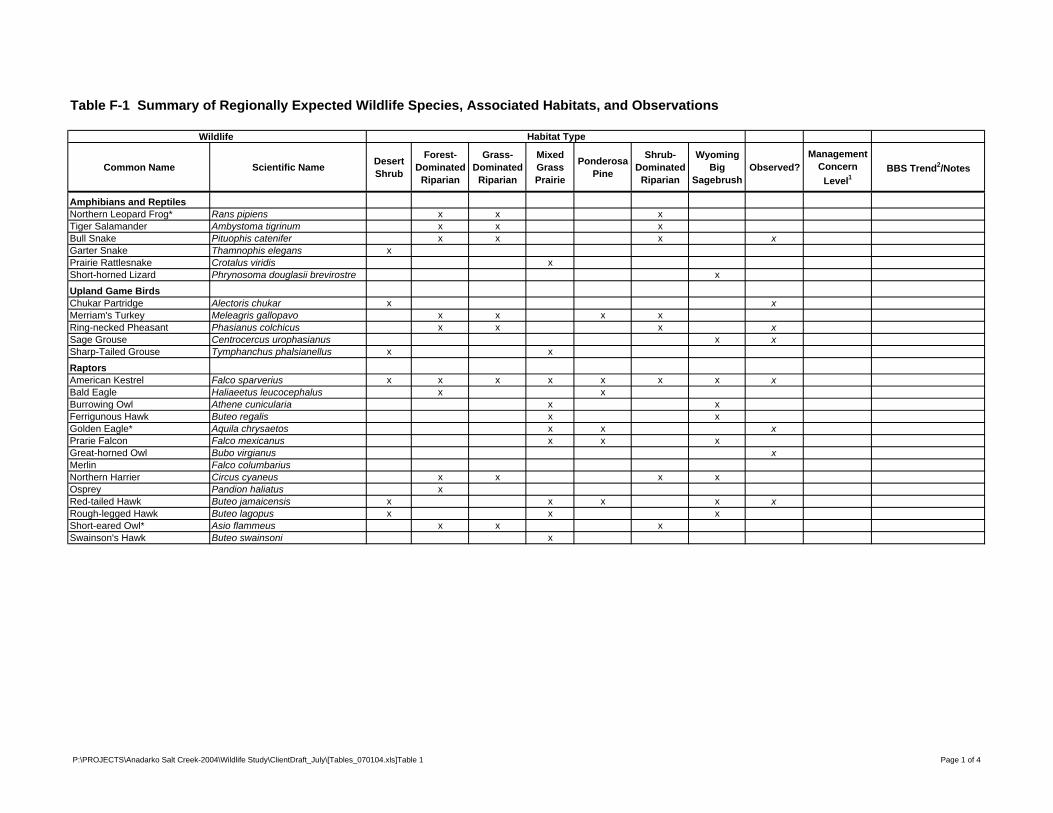
Table F-1 Summary of Regionally Expected Wildlife Species, Associated Habitats, and Observations
Wildlife Habitat Type
Common Name Scientific Name Desert Shrub
Forest-Dominated
Riparian
Grass-Dominated
Riparian
Mixed Grass Prairie
Ponderosa Pine
Shrub-Dominated
Riparian
Wyoming Big
SagebrushObserved?
Management Concern
Level1BBS Trend2/Notes
Amphibians and ReptilesNorthern Leopard Frog* Rans pipiens x x xTiger Salamander Ambystoma tigrinum x x xBull Snake Pituophis catenifer x x x xGarter Snake Thamnophis elegans xPrairie Rattlesnake Crotalus viridis xShort-horned Lizard Phrynosoma douglasii brevirostre x
Upland Game BirdsChukar Partridge Alectoris chukar x xMerriam's Turkey Meleagris gallopavo x x x xRing-necked Pheasant Phasianus colchicus x x x xSage Grouse Centrocercus urophasianus x xSharp-Tailed Grouse Tymphanchus phalsianellus x x
RaptorsAmerican Kestrel Falco sparverius x x x x x x x xBald Eagle Haliaeetus leucocephalus x xBurrowing Owl Athene cunicularia x xFerrigunous Hawk Buteo regalis x xGolden Eagle* Aquila chrysaetos x x xPrarie Falcon Falco mexicanus x x xGreat-horned Owl Bubo virgianus xMerlin Falco columbariusNorthern Harrier Circus cyaneus x x x xOsprey Pandion haliatus xRed-tailed Hawk Buteo jamaicensis x x x x xRough-legged Hawk Buteo lagopus x x xShort-eared Owl* Asio flammeus x x xSwainson's Hawk Buteo swainsoni x
P:\PROJECTS\Anadarko Salt Creek-2004\Wildlife Study\ClientDraft_July\[Tables_070104.xls]Table 1 Page 1 of 4
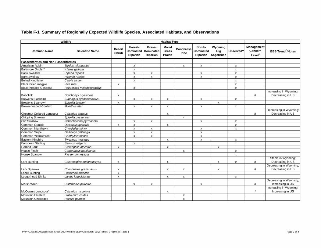
Table F-1 Summary of Regionally Expected Wildlife Species, Associated Habitats, and Observations
Wildlife Habitat Type
Common Name Scientific Name Desert Shrub
Forest-Dominated
Riparian
Grass-Dominated
Riparian
Mixed Grass Prairie
Ponderosa Pine
Shrub-Dominated
Riparian
Wyoming Big
SagebrushObserved?
Management Concern
Level1BBS Trend2/Notes
Passeriformes and Non-PasseriformesAmerican Robin Turdus migratorius x x x xBaltimore Oriole** Icterus galbula x xBank Swallow Riparia Riparia x x x xBarn Swallow Hirundo rustica x x x xBelted Kingfisher Ceryle alcyon x xBlack-billed magpie Pica pica x xBlack-headed Gosbeak Pheucticus melanocephalus x x
Bobolink Dolichonyx oryzivorus x IIIncreasing in Wyoming;
Decreasing in USBrewer's Blackbird Euphagus cyanocephalus x x x x xBrewer's Sparrow* Spizella breweri x xBrown-headed Cowbird Molothus ater x x x x x
Chestnut Collared Longspur Calcarius ornatus x IIDecreasing in Wyoming;
Decreasing in USChipping Sparrow Spizella passerina xCliff Swallow Petrochelidon pyrrhonota x x x xCommon Grackle Quiscalus quiscula x x x xCommon Nighthawk Chordeiles minor x x x xCommon Snipe Gallinago gallinago x x xCommon Yellowthroat Geothylpis trichas x x xEastern Kingbird Tyrannus tyrannus x x xEuropean Starling Sturnus vulgaris x xHorned Lark Eremophila alpestris x x xHouse Finch Carpodacus mexicanus x xHouse Sparrow Passer domesticus x
Lark Bunting Calamospiza melanocoryos x x x x IIStable in Wyoming; Decreasing in US
Lark Sparrow Chondestes grammacus x x x x IIDecreasing in Wyoming;
Decreasing in USLazuli Bunting Passerina amoena xLoggerhead Shrike Lanius ludovicianus x x x x
Marsh Wren Cistothorus palustris x x x IIDecreasing in Wyoming;
Increasing in US
McCown's Longspur* Calcarius mccownii x IIncreasing in Wyoming;
Increasing in USMountain Bluebird Sialia currucoides xMountain Chickadee Poecile gambeli x
P:\PROJECTS\Anadarko Salt Creek-2004\Wildlife Study\ClientDraft_July\[Tables_070104.xls]Table 1 Page 2 of 4
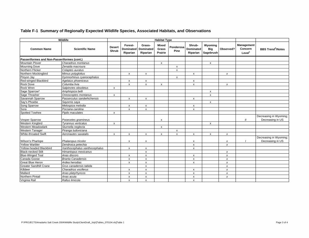
Table F-1 Summary of Regionally Expected Wildlife Species, Associated Habitats, and Observations
Wildlife Habitat Type
Common Name Scientific Name Desert Shrub
Forest-Dominated
Riparian
Grass-Dominated
Riparian
Mixed Grass Prairie
Ponderosa Pine
Shrub-Dominated
Riparian
Wyoming Big
SagebrushObserved?
Management Concern
Level1BBS Trend2/Notes
Passeriformes and Non-Passeriformes (cont.)Mountain Plover Charadrius montanus x xMourning Dove Zenaida macroura xNorthern Flicker Colaptes auratus xNorthern Mockingbird Mimus polyglottus x x x xPinyon Jay Gymnorhinus cyanocephalus xRed-winged Blackbird Agelaius phoeniceus x x xRock Dove Columba livia x x x x xRock Wren Salpinctes obsoletus xSage Sparrow* Amphispiza belli xSage Thrasher Oreoscoptes montanus x xSavannah Sparrow Passerculus sandwhichensis x x xSay's Phoebe Sayornis saya xSong Sparrow Melospiza melodia x x xSora Porzana carolina x x xSpotted Towhee Pipilo maculates x
Vesper Sparrow Pooecetes gramineus x IIDecreasing in Wyoming;
Decreasing in USWestern Kingbird Tyrannus verticalus x xWestern Meadowlark Sturnella neglecta xWestern Tanager Piranga ludoviciana xWhite-throated Swift Aeronautes saxatalis x x x x x x x x
Wilson's Pharlope Phalaropus tricolor x x x x IDecreasing in Wyoming;
Decreasing in USYellow Warbler Dendroica petechia x xYellow-headed Blackbird Xanthocephalus xanthocephalus x x xBlack-necked Stilt Himantopus mexicanus x xBlue-Winged Teal Anas discors x x x xCanada Goose Branta Canadensis x x x xGreat Blue Heron Ardea herodias x x x xGreater Sandhill Crane Grus canadensis tabida x xKilldeer Charadrius vociferus x x x xMallard Anas platyrhyncos x x x xNorthern Pintail Anas acuta x x x xVirginia Rail Rallus limicola x x x
P:\PROJECTS\Anadarko Salt Creek-2004\Wildlife Study\ClientDraft_July\[Tables_070104.xls]Table 1 Page 3 of 4
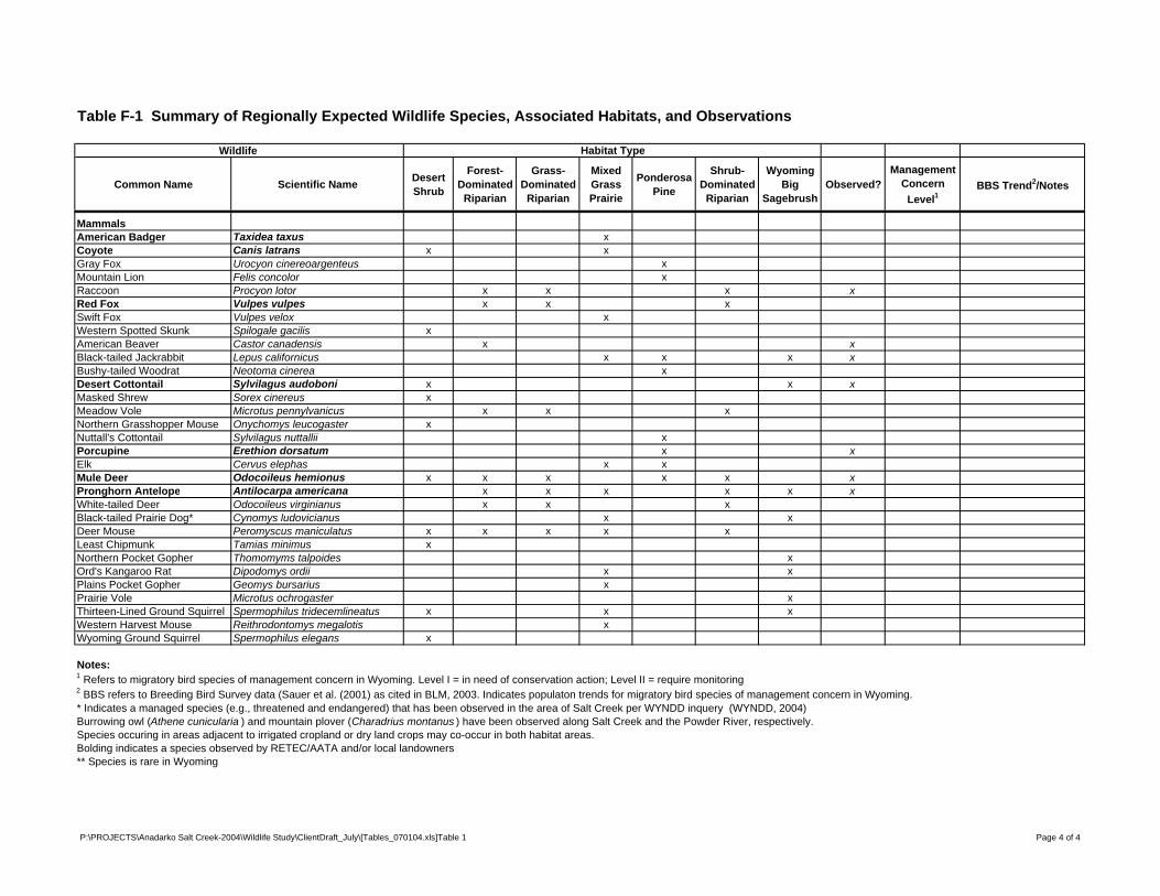
Table F-1 Summary of Regionally Expected Wildlife Species, Associated Habitats, and Observations
Wildlife Habitat Type
Common Name Scientific Name Desert Shrub
Forest-Dominated
Riparian
Grass-Dominated
Riparian
Mixed Grass Prairie
Ponderosa Pine
Shrub-Dominated
Riparian
Wyoming Big
SagebrushObserved?
Management Concern
Level1BBS Trend2/Notes
MammalsAmerican Badger Taxidea taxus xCoyote Canis latrans x xGray Fox Urocyon cinereoargenteus xMountain Lion Felis concolor xRaccoon Procyon lotor x x x xRed Fox Vulpes vulpes x x xSwift Fox Vulpes velox xWestern Spotted Skunk Spilogale gacilis xAmerican Beaver Castor canadensis x xBlack-tailed Jackrabbit Lepus californicus x x x xBushy-tailed Woodrat Neotoma cinerea xDesert Cottontail Sylvilagus audoboni x x xMasked Shrew Sorex cinereus xMeadow Vole Microtus pennylvanicus x x xNorthern Grasshopper Mouse Onychomys leucogaster xNuttall's Cottontail Sylvilagus nuttallii xPorcupine Erethion dorsatum x xElk Cervus elephas x xMule Deer Odocoileus hemionus x x x x x xPronghorn Antelope Antilocarpa americana x x x x x xWhite-tailed Deer Odocoileus virginianus x x xBlack-tailed Prairie Dog* Cynomys ludovicianus x xDeer Mouse Peromyscus maniculatus x x x x xLeast Chipmunk Tamias minimus xNorthern Pocket Gopher Thomomyms talpoides xOrd's Kangaroo Rat Dipodomys ordii x xPlains Pocket Gopher Geomys bursarius xPrairie Vole Microtus ochrogaster xThirteen-Lined Ground Squirrel Spermophilus tridecemlineatus x x xWestern Harvest Mouse Reithrodontomys megalotis xWyoming Ground Squirrel Spermophilus elegans x
Notes:1 Refers to migratory bird species of management concern in Wyoming. Level I = in need of conservation action; Level II = require monitoring2 BBS refers to Breeding Bird Survey data (Sauer et al. (2001) as cited in BLM, 2003. Indicates populaton trends for migratory bird species of management concern in Wyoming. * Indicates a managed species (e.g., threatened and endangered) that has been observed in the area of Salt Creek per WYNDD inquery (WYNDD, 2004)Burrowing owl (Athene cunicularia ) and mountain plover (Charadrius montanus ) have been observed along Salt Creek and the Powder River, respectively.Species occuring in areas adjacent to irrigated cropland or dry land crops may co-occur in both habitat areas.Bolding indicates a species observed by RETEC/AATA and/or local landowners** Species is rare in Wyoming
P:\PROJECTS\Anadarko Salt Creek-2004\Wildlife Study\ClientDraft_July\[Tables_070104.xls]Table 1 Page 4 of 4
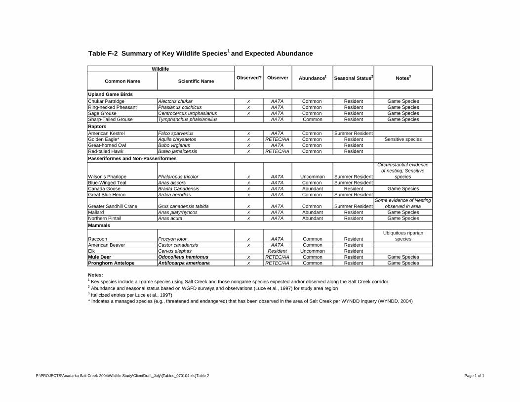
Table F-2 Summary of Key Wildlife Species1 and Expected Abundance
Wildlife
Common Name Scientific Name
Upland Game BirdsChukar Partridge Alectoris chukar x AATA Common Resident Game SpeciesRing-necked Pheasant Phasianus colchicus x AATA Common Resident Game SpeciesSage Grouse Centrocercus urophasianus x AATA Common Resident Game SpeciesSharp-Tailed Grouse Tymphanchus phalsianellus AATA Common Resident Game SpeciesRaptorsAmerican Kestrel Falco sparverius x AATA Common Summer ResidentGolden Eagle* Aquila chrysaetos x RETEC/AA Common Resident Sensitive speciesGreat-horned Owl Bubo virgianus x AATA Common ResidentRed-tailed Hawk Buteo jamaicensis x RETEC/AA Common ResidentPasseriformes and Non-Passeriformes
Wilson's Pharlope Phalaropus tricolor x AATA Uncommon Summer Resident
Circumstantial evidence of nesting; Sensitive
speciesBlue-Winged Teal Anas discors x AATA Common Summer ResidentCanada Goose Branta Canadensis x AATA Abundant Resident Game SpeciesGreat Blue Heron Ardea herodias x AATA Common Summer Resident
Greater Sandhill Crane Grus canadensis tabida x AATA Common Summer ResidentSome evidence of Nesting
observed in areaMallard Anas platyrhyncos x AATA Abundant Resident Game SpeciesNorthern Pintail Anas acuta x AATA Abundant Resident Game SpeciesMammals
Raccoon Procyon lotor x AATA Common ResidentUbiquitous riparian
speciesAmerican Beaver Castor canadensis x AATA Common ResidentElk Cervus elephas Resident Uncommon ResidentMule Deer Odocoileus hemionus x RETEC/AA Common Resident Game SpeciesPronghorn Antelope Antilocarpa americana x RETEC/AA Common Resident Game Species
Notes:1 Key species include all game species using Salt Creek and those nongame species expected and/or observed along the Salt Creek corridor.2 Abundance and seasonal status based on WGFD surveys and observations (Luce et al., 1997) for study area region3 Italicized entries per Luce et al., 1997)* Indcates a managed species (e.g., threatened and endangered) that has been observed in the area of Salt Creek per WYNDD inquery (WYNDD, 2004)
Abundance2 Seasonal Status2Observed? Notes3Observer
P:\PROJECTS\Anadarko Salt Creek-2004\Wildlife Study\ClientDraft_July\[Tables_070104.xls]Table 2 Page 1 of 1

Figures
hghg
r76
r79
78 r77
r76
r79
78 r77
r76
t39
t37
r78
r77
SALT CR
onason Campb
Converse
M i d w e s tM i d w e s t E d g e r t o nE d g e r t o n
SALT CR
CASTLE CR
N o r t h C o t t o n wo o d C r e e k
Seve
n L C
reek
Big Bull Cedar Creek
L i t t l e B u l l C e d a r C r e e k
C o t t o n w o o d C r e e k
Bobc
at Cre
ek
ooked Creek
MEADOW CR
SALT CR
DUGO
UT C
R
Bullw
hack
er C
reek
Horse
Littl
e Bul
lwha
cker
Cre
ek
DER R
Seventeenmile Creek
COTTONWOOD CR
Little Teapot Cr
East Teapot Creek
TEAPOT C
R
Coal Draw
HABITAT ASSOCIATED WITH THE SALT CREEK WATERSHED
p
1 0 1 2 3 4 50.5Miles
DWN. BY: KBL/ftc FILE: T:/ANADARKO_SALTCREEK/PROJECTS/WILDLIFESTUDYAREA.MXDDATE: 7-02-04 FIGURE F-1
£
ANADARKOSALT CREEK INVESTIGATION
APC02-18086-460
PRIMARY HABITAT
Desert shrub
Dry-land crops
Forest-dominated riparian
Grass-dominated riparian
Irrigated crops
Mixed grass prairie
Ponderosa pine
Shrub-dominated riparian
Wyoming big sagebrush
Wildlife Study Area
Water Quality Study Area
LEGEND
ANADARKOSALT CREEK UAA
BIG GAME HUNT AREASAND STRATEGIC HABITAT
IN SALT CREEK APC02-18086-460
0 4 82 Miles
T:/ANADARKO_SALTCREEK/PROJECTS/WildlifeDist_Comb.MXDDWN. BY: KBL/ftc FILE: DATE: 7/2/04 FIGURE F-2
p
£
!(
!(!(
!(!(
!(
!(!(!(
!(!(
!(!(
!(!(
!(
!(!(!(
!( !(!(
!(
!(
r76
r75
t39
r78
r77
SHERIDAN REGIONSALT CREEK SAGEBRUSH STEPPE
PRIORITY 5
CASPER REGIONORMSBY
PRIORITY 10
ona
Cam
pbell
Converse
Bullw
hack
er C
reek
Horse
Littl
e Bu
llwha
cker
Cre
ek
Seventeenmile Creek
COTTONWOOD CR
SALT CR
SALT
CR
CASTLE CR
N o r t h C o t t o n w
o o d C r e e k
Seve
n L
Cree
k
Big Bull Cedar Creek
Little Bull Cedar Creek
Bobc
at C
reek
Crooked Creek
MEADOW CR
SALT CR
DU
GO
UT
CR
Little Teapot Cr
East Teapot Creek
TEAP
OT C
R
Coal Draw
M i d w e s tM i d w e s t E d g e r t o nE d g e r t o n
r76
r75
t39
r78
r77
PUMPKIN BUTTES HERD (320)HUNT AREA 29
UMPKIN BUTTES HERD (320)HUNT AREA 31
NORTH CONVERSE HERD (755)HUNT AREA 158
rona
Cam
pbell
Converse
Bullw
hack
er C
reek
Horse
Cr
Littl
e Bu
llwha
cker
Cre
ek
Seventeenmile Creek
COTTONWOOD CR
SALT CR
SALT
CR
CASTLE CR
N o r t h C o t t o n w
o o d C r e e k
Seve
n L
Cree
k
Big Bull Cedar Creek
Little Bull Cedar Creek
Bobc
at C
reek
Crooked Creek
MEADOW CR
SALT CR
DU
GO
UT
CR
Little Teapot Cr
East Teapot Creek
TEAP
OT CR
Coal Draw
M i d w e s tM i d w e s t E d g e r t o nE d g e r t o n
r76
r75
t39
r78
r77
CRAZY WOMAN HERD (318)HUNT AREA 113
NORTH CONVERSE HERD (748)HUNT AREA 25
rona
Cam
pbell
Converse
Bullw
hack
er C
reek
Horse
Littl
e Bul
lwha
cker
Cre
ek
Seventeenmile Creek
COTTONWOOD CR
SALT CR
SALT
CR
CASTLE CR
N o r t h C o t t o n w
o o d C r e e k
Seve
n L
Cree
k
Big Bull Cedar Creek
Little Bull Cedar Creek
Bobc
at C
reek
Crooked Creek
MEADOW CR
SALT CR
DU
GO
UT
CR
Little Teapot Cr
East Teapot Creek
TEAP
OT CR
Coal Draw
M i d w e s tM i d w e s t E d g e r t o nE d g e r t o n
r76
r75
t39
r78
r77
PINE RIDGE HERD (743)HUNT AREA 122
ona
Cam
pbell
Converse
Bullw
hack
er C
reek
H
Littl
e Bul
lwha
cker
Cre
ek
Seventeenmile Creek
COTTONWOOD CR
SALT CR
SALT
CR
CASTLE CR
N o r t h C o t t o n w
o o d C r e e k
Seve
n L
Cree
k
Big Bull Cedar Creek
Little Bull Cedar Creek
Bobc
at C
reek
Crooked Creek
MEADOW CR
SALT CR
DU
GOU
T CR
Little Teapot Cr
East Teapot Creek
TEAP
OT CR
Coal Draw
M i d w e s tM i d w e s t E d g e r t o nE d g e r t o n
STRATEGIC HABITAT AND SAGE GROUSE
LEK LOCATIONS
MULE DEER HUNT AREAS
PRONGHORN ANTELOPEHUNT AREAS
ELKHUNT AREAS
!( OCCUPIED LEKS (2003)
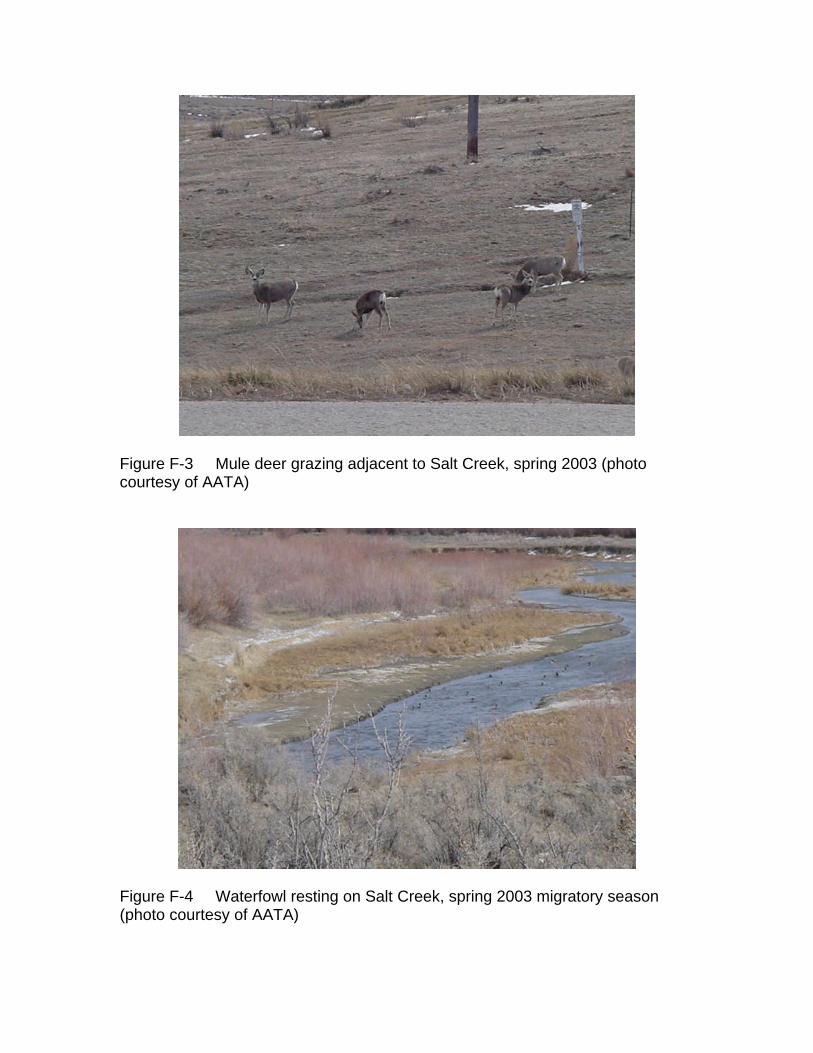
Figure F-3 Mule deer grazing adjacent to Salt Creek, spring 2003 (photo courtesy of AATA)
Figure F-4 Waterfowl resting on Salt Creek, spring 2003 migratory season (photo courtesy of AATA)
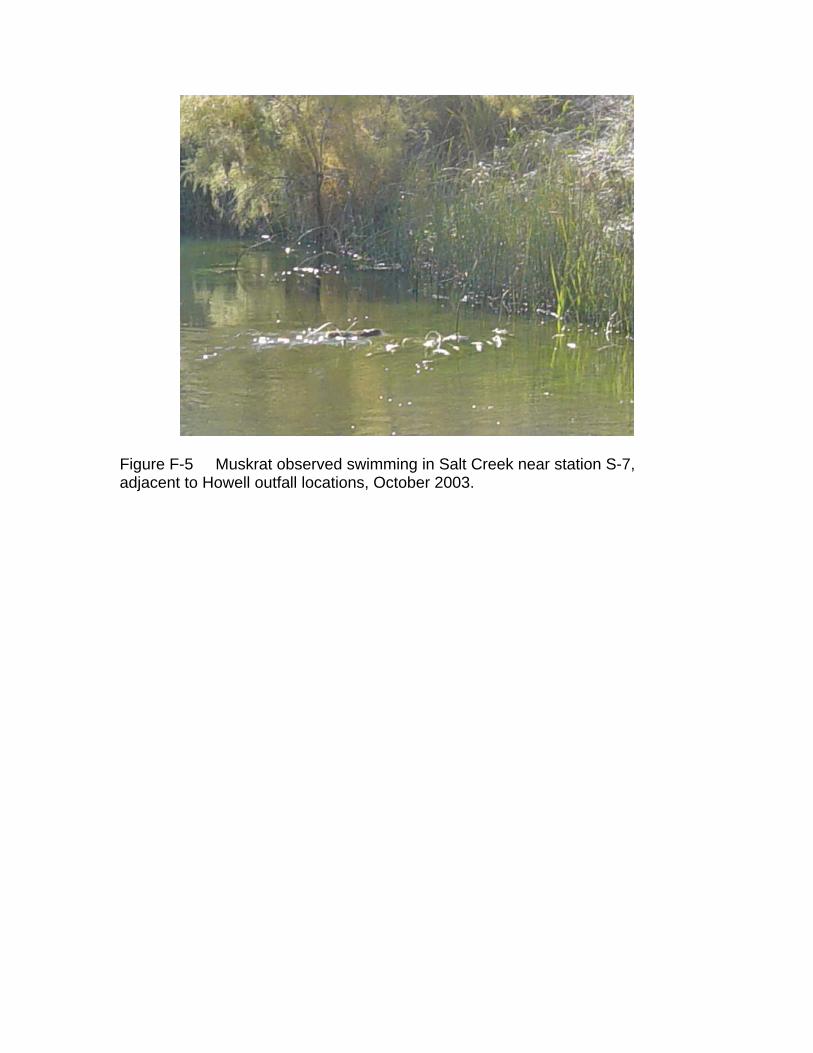
Figure F-5 Muskrat observed swimming in Salt Creek near station S-7, adjacent to Howell outfall locations, October 2003.