antarctic expedition cruise 11 november 20...
TRANSCRIPT
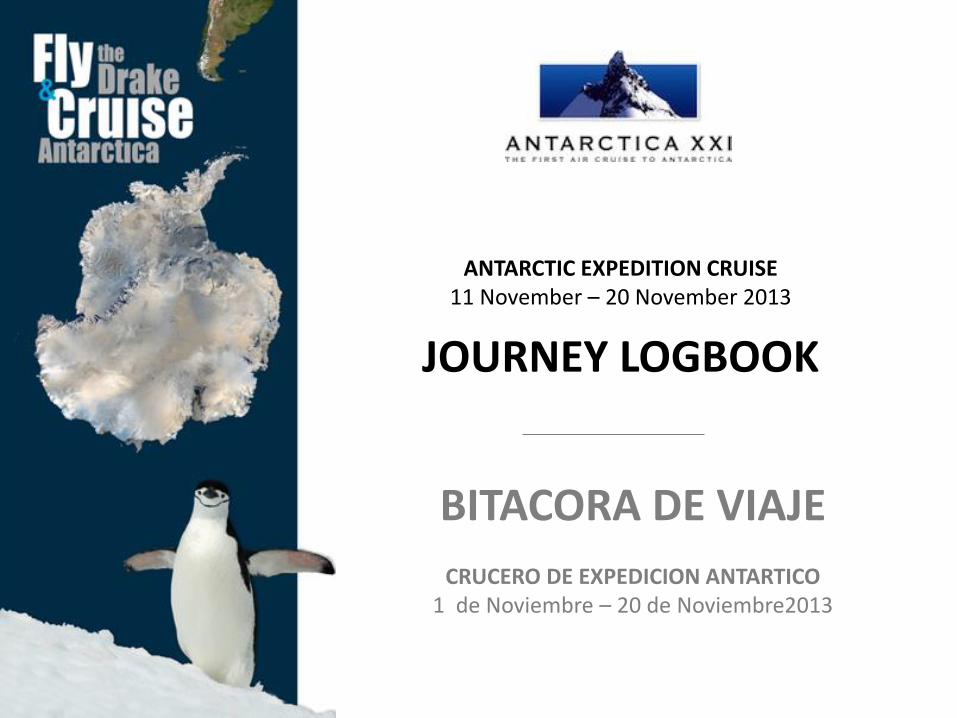
BITACORA DE VIAJE
CRUCERO DE EXPEDICION ANTARTICO 1 de Noviembre – 20 de Noviembre2013
ANTARCTIC EXPEDITION CRUISE 11 November – 20 November 2013
JOURNEY LOGBOOK

w w w . a n t a r c t i c a x x i . c o m
ANTARCTICA XXI thanks you for having participated in this exciting adventure. We hope that this Journey Logbook will help remembering such an unforgettable experience!
ANTARCTICA XXI le agradece haber participado en esta fantástica aventura. Esperamos que esta Bitácora de Viaje le ayude a recordar una experiencia inolvidable!
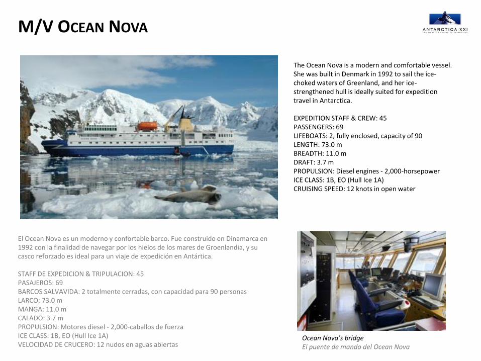
M/V OCEAN NOVA
The Ocean Nova is a modern and comfortable vessel. She was built in Denmark in 1992 to sail the ice-choked waters of Greenland, and her ice-strengthened hull is ideally suited for expedition travel in Antarctica. EXPEDITION STAFF & CREW: 45 PASSENGERS: 69 LIFEBOATS: 2, fully enclosed, capacity of 90 LENGTH: 73.0 m BREADTH: 11.0 m DRAFT: 3.7 m PROPULSION: Diesel engines - 2,000-horsepower ICE CLASS: 1B, EO (Hull Ice 1A) CRUISING SPEED: 12 knots in open water
El Ocean Nova es un moderno y confortable barco. Fue construido en Dinamarca en 1992 con la finalidad de navegar por los hielos de los mares de Groenlandia, y su casco reforzado es ideal para un viaje de expedición en Antártica. STAFF DE EXPEDICION & TRIPULACION: 45 PASAJEROS: 69 BARCOS SALVAVIDA: 2 totalmente cerradas, con capacidad para 90 personas LARCO: 73.0 m MANGA: 11.0 m CALADO: 3.7 m PROPULSION: Motores diesel - 2,000-caballos de fuerza ICE CLASS: 1B, EO (Hull Ice 1A) VELOCIDAD DE CRUCERO: 12 nudos en aguas abiertas
Ocean Nova’s bridge El puente de mando del Ocean Nova

20 November 2013 20 de Noviembre 2013
DAILY PROGRAMME PROGRAMA DEL DIA
Welcome to Ushuaia! Bienvenidos a Ushuaia!
15:00-16:00 Embarkation – Welcome aboard MV Ocean Nova
Embarque – Bienvenidos al MV Ocean Nova
~ 16:30 (*)
Welcome briefing, mandatory emergency briefing and lifeboat drill in the Panorama lounge (Deck 5)
Charla de bienvenida, charla obligatoria de emergencia y zafarrancho en el Salón Panorámico (Cubierta 5)
~ 17:00 (*) Ocean Nova sets sail into the Beagle Channel
Zarpe del Ocean Nova y navegación en el Canal Beagle
19:00 (*)
Welcome cocktail with the Captain and Staff introduction in the Panorama Lounge (Deck 5)
Cocktail de bienvenida con el Capitán y presentación del equipo en el Salón Panorámico (Cubierta 5)
19:30 Dinner Cena
(*) TO BE CONFIRMED: Please be alert for announcements on the PA system
A CONFIRMAR: Por favor estén atentos a los anuncios por el sistema de altavoz
“Glittering white, shining blue, raven black, in the
light of the sun the land looks like a fairytale.
Pinnacle after pinnacle, peak after peak, crevassed,
wild as any land on our globe, it lies, unseen and
untrodden”.
Roald Amundsen
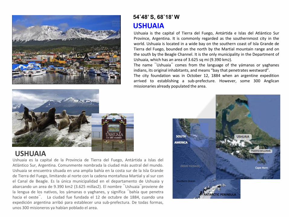
USHUAIA Ushuaia is the capital of Tierra del Fuego, Antártida e Islas del Atlántico Sur Province, Argentina. It is commonly regarded as the southernmost city in the world. Ushuaia is located in a wide bay on the southern coast of Isla Grande de Tierra del Fuego, bounded on the north by the Martial mountain range and on the south by the Beagle Channel. It is the only municipality in the Department of Ushuaia, which has an area of 3.625 sq mi (9.390 km2). The name ¨Ushuaia¨ comes from the language of the yámanas or yaghanes indians, its original inhabitants, and means “bay that penetrates westward”. The city foundation was in October 12, 1884 when an argentine expedition arrived to establishing a sub-prefecture. However, some 300 Anglican missionaries already populated the area.
Ushuaia es la capital de la Provincia de Tierra del Fuego, Antártida a Islas del Atlántico Sur, Argentina. Comunmente nombrada la ciudad más austral del mundo. Ushuaia se encuentra situada en una amplia bahía en la costa sur de la Isla Grande de Tierra del Fuego, limitando al norte con la cadena montañosa Martial y al sur con el Canal de Beagle. Es la única municipalidad en el departamento de Ushuaia y abarcando un area de 9.390 km2 (3.625 millas2). El nombre ¨Ushuaia¨proviene de la lengua de los nativos, los yámanas o yaghanes, y significa ¨bahía que penetra hacia el oeste¨. La ciudad fue fundada el 12 de octubre de 1884, cuando una expedición argentina arribó para establecer una sub-prefectura. De todas formas, unos 300 misioneros ya habían poblado el area.
USHUAIA
54˚48’ S, 68˚18’ W
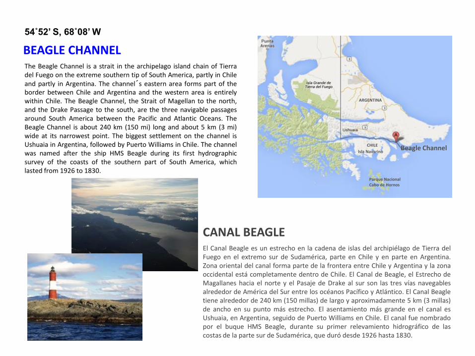
The Beagle Channel is a strait in the archipelago island chain of Tierra del Fuego on the extreme southern tip of South America, partly in Chile and partly in Argentina. The channel´s eastern area forms part of the border between Chile and Argentina and the western area is entirely within Chile. The Beagle Channel, the Strait of Magellan to the north, and the Drake Passage to the south, are the three navigable passages around South America between the Pacific and Atlantic Oceans. The Beagle Channel is about 240 km (150 mi) long and about 5 km (3 mi) wide at its narrowest point. The biggest settlement on the channel is Ushuaia in Argentina, followed by Puerto Williams in Chile. The channel was named after the ship HMS Beagle during its first hydrographic survey of the coasts of the southern part of South America, which lasted from 1926 to 1830.
El Canal Beagle es un estrecho en la cadena de islas del archipiélago de Tierra del Fuego en el extremo sur de Sudamérica, parte en Chile y en parte en Argentina. Zona oriental del canal forma parte de la frontera entre Chile y Argentina y la zona occidental está completamente dentro de Chile. El Canal de Beagle, el Estrecho de Magallanes hacia el norte y el Pasaje de Drake al sur son las tres vías navegables alrededor de América del Sur entre los océanos Pacífico y Atlántico. El Canal Beagle tiene alrededor de 240 km (150 millas) de largo y aproximadamente 5 km (3 millas) de ancho en su punto más estrecho. El asentamiento más grande en el canal es Ushuaia, en Argentina, seguido de Puerto Williams en Chile. El canal fue nombrado por el buque HMS Beagle, durante su primer relevamiento hidrográfico de las costas de la parte sur de Sudamérica, que duró desde 1926 hasta 1830.
BEAGLE CHANNEL
54˚52’ S, 68˚08’ W
CANAL BEAGLE
Parque Nacional Cabo de Hornos
Isla Navarino
ARGENTINA
CHILE Beagle Channel
DAILY PROGRAMME PROGRAMA DEL DIA
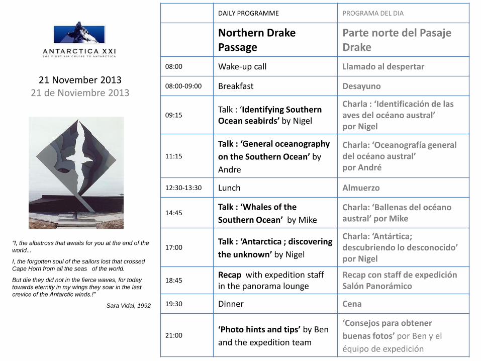
Northern Drake Passage
Parte norte del Pasaje Drake
08:00 Wake-up call Llamado al despertar
08:00-09:00 Breakfast Desayuno
09:15 Talk : ‘Identifying Southern Ocean seabirds’ by Nigel
Charla : ‘Identificación de las aves del océano austral’ por Nigel
11:15
Talk : ‘General oceanography
on the Southern Ocean’ by
Andre
Charla: ‘Oceanografía general del océano austral’ por André
12:30-13:30 Lunch Almuerzo
14:45 Talk : ‘Whales of the
Southern Ocean’ by Mike
Charla: ‘Ballenas del océano austral’ por Mike
17:00 Talk : ‘Antarctica ; discovering
the unknown’ by Nigel
Charla: ‘Antártica; descubriendo lo desconocido’ por Nigel
18:45 Recap with expedition staff in the panorama lounge
Recap con staff de expedición Salón Panorámico
19:30 Dinner Cena
21:00 ‘Photo hints and tips’ by Ben
and the expedition team
‘Consejos para obtener
buenas fotos’ por Ben y el
équipo de expedición
21 November 2013 21 de Noviembre 2013
“I, the albatross that awaits for you at the end of the
world...
I, the forgotten soul of the sailors lost that crossed
Cape Horn from all the seas of the world.
But die they did not in the fierce waves, for today
towards eternity in my wings they soar in the last
crevice of the Antarctic winds.!”
Sara Vidal, 1992
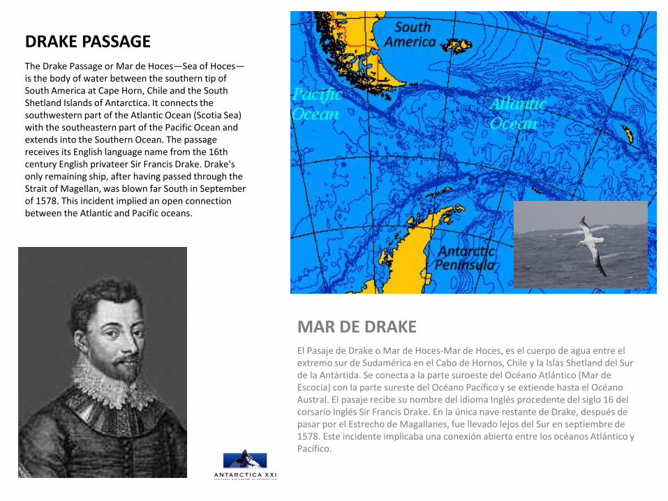
The Drake Passage or Mar de Hoces—Sea of Hoces—is the body of water between the southern tip of South America at Cape Horn, Chile and the South Shetland Islands of Antarctica. It connects the southwestern part of the Atlantic Ocean (Scotia Sea) with the southeastern part of the Pacific Ocean and extends into the Southern Ocean. The passage receives its English language name from the 16th century English privateer Sir Francis Drake. Drake's only remaining ship, after having passed through the Strait of Magellan, was blown far South in September of 1578. This incident implied an open connection between the Atlantic and Pacific oceans.
DRAKE PASSAGE
El Pasaje de Drake o Mar de Hoces-Mar de Hoces, es el cuerpo de agua entre el extremo sur de Sudamérica en el Cabo de Hornos, Chile y la Islas Shetland del Sur de la Antártida. Se conecta a la parte suroeste del Océano Atlántico (Mar de Escocia) con la parte sureste del Océano Pacífico y se extiende hasta el Océano Austral. El pasaje recibe su nombre del idioma Inglés procedente del siglo 16 del corsario Inglés Sir Francis Drake. En la única nave restante de Drake, después de pasar por el Estrecho de Magallanes, fue llevado lejos del Sur en septiembre de 1578. Este incidente implicaba una conexión abierta entre los océanos Atlántico y Pacífico.
MAR DE DRAKE

DAILY PROGRAMME PROGRAMA DEL DIA
Southern Drake Passage
El Sur del Mar de Drake
08:00 Wake-up call Llamado al despertar
08:00-09:00
Breakfast Desayuno
09:15 ‘Sea Ice dynamics’ by Andre
‘Dinámica del mar congelado’ por André
11:15 ‘The River of Krill’ by Jamie
‘El rio de Krill’ por Jamie
12:30-13:30
Lunch Almuerzo
14:45
‘Going ashore in the Antarctic’ and ‘Zodiac’ briefings by Jamie and Ben - MANDATORY BRIEFING -
‘Desembarcar en la Antártica con los botes Zodiac’ por Jamie y Ben - CHARLA OBLIGATORIA -
17:00 ‘Seals of the Southern Ocean’ by Mike
‘Focas del Océano Austral’ por Mike
18:45 ‘Recap and briefing’ with the expedition staff
‘Charla de recapitulación’ con el equipo de expedición
19:30 Dinner Cena
22 November 2013 22 de Noviembre 2013
“The ice was here, the ice was there, the ice was all
around: it cracked and growled, and roared and
howled, like noises in a sound!”
Coleridge, The Ancient Mariner
DAILY PROGRAMME PROGRAMA DEL DIA
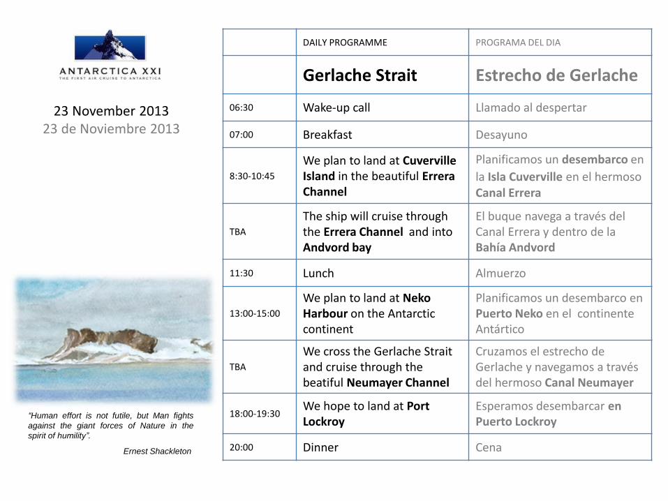
Gerlache Strait Estrecho de Gerlache
06:30 Wake-up call Llamado al despertar
07:00 Breakfast Desayuno
8:30-10:45
We plan to land at Cuverville Island in the beautiful Errera Channel
Planificamos un desembarco en
la Isla Cuverville en el hermoso Canal Errera
TBA
The ship will cruise through the Errera Channel and into Andvord bay
El buque navega a través del Canal Errera y dentro de la Bahía Andvord
11:30 Lunch Almuerzo
13:00-15:00
We plan to land at Neko Harbour on the Antarctic continent
Planificamos un desembarco en Puerto Neko en el continente Antártico
TBA
We cross the Gerlache Strait and cruise through the beatiful Neumayer Channel
Cruzamos el estrecho de Gerlache y navegamos a través del hermoso Canal Neumayer
18:00-19:30 We hope to land at Port Lockroy
Esperamos desembarcar en Puerto Lockroy
20:00 Dinner Cena
“Human effort is not futile, but Man fights
against the giant forces of Nature in the
spirit of humility”.
Ernest Shackleton
23 November 2013 23 de Noviembre 2013
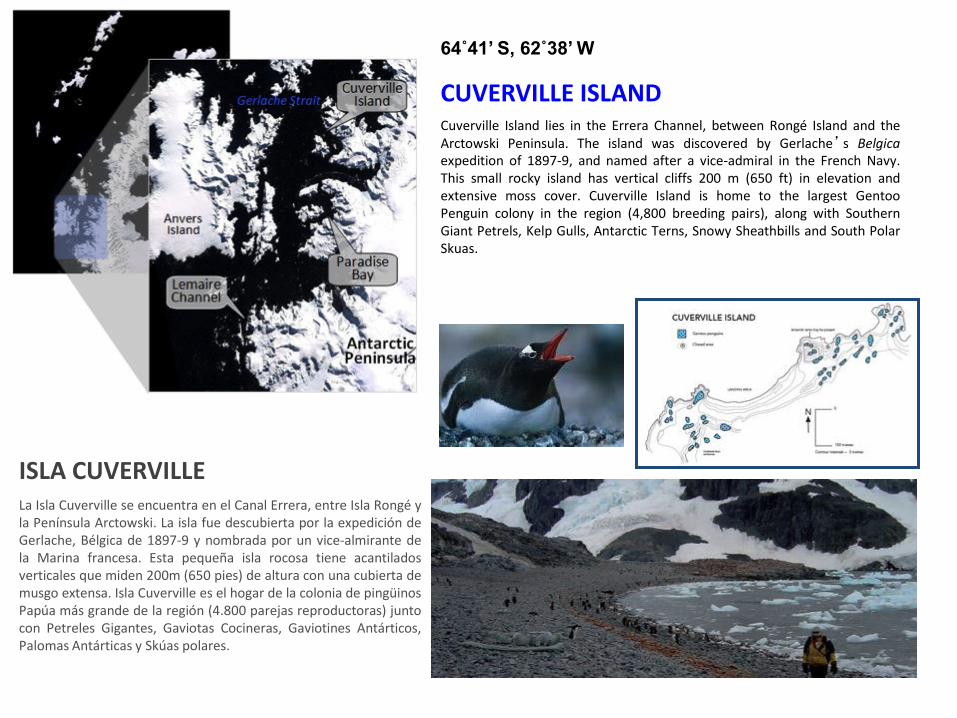
La Isla Cuverville se encuentra en el Canal Errera, entre Isla Rongé y la Península Arctowski. La isla fue descubierta por la expedición de Gerlache, Bélgica de 1897-9 y nombrada por un vice-almirante de la Marina francesa. Esta pequeña isla rocosa tiene acantilados verticales que miden 200m (650 pies) de altura con una cubierta de musgo extensa. Isla Cuverville es el hogar de la colonia de pingüinos Papúa más grande de la región (4.800 parejas reproductoras) junto con Petreles Gigantes, Gaviotas Cocineras, Gaviotines Antárticos, Palomas Antárticas y Skúas polares.
CUVERVILLE ISLAND
64˚41’ S, 62˚38’ W
ISLA CUVERVILLE
Cuverville Island lies in the Errera Channel, between Rongé Island and the Arctowski Peninsula. The island was discovered by Gerlache’s Belgica expedition of 1897-9, and named after a vice-admiral in the French Navy. This small rocky island has vertical cliffs 200 m (650 ft) in elevation and extensive moss cover. Cuverville Island is home to the largest Gentoo Penguin colony in the region (4,800 breeding pairs), along with Southern Giant Petrels, Kelp Gulls, Antarctic Terns, Snowy Sheathbills and South Polar Skuas.
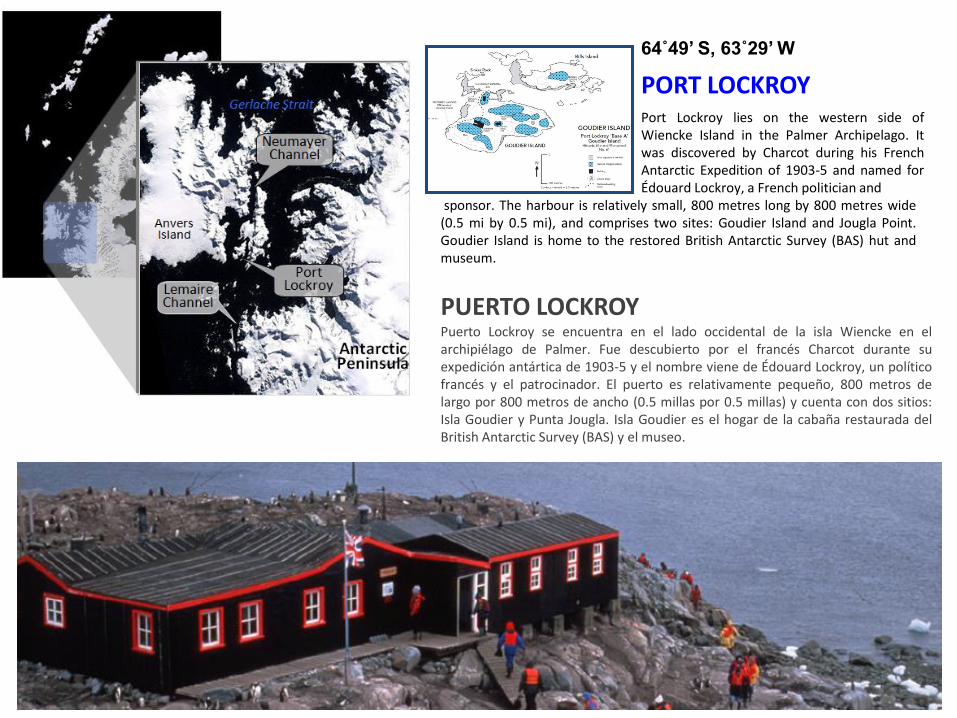
PORT LOCKROY
64˚49’ S, 63˚29’ W
Puerto Lockroy se encuentra en el lado occidental de la isla Wiencke en el archipiélago de Palmer. Fue descubierto por el francés Charcot durante su expedición antártica de 1903-5 y el nombre viene de Édouard Lockroy, un político francés y el patrocinador. El puerto es relativamente pequeño, 800 metros de largo por 800 metros de ancho (0.5 millas por 0.5 millas) y cuenta con dos sitios: Isla Goudier y Punta Jougla. Isla Goudier es el hogar de la cabaña restaurada del British Antarctic Survey (BAS) y el museo.
PUERTO LOCKROY
Port Lockroy lies on the western side of Wiencke Island in the Palmer Archipelago. It was discovered by Charcot during his French Antarctic Expedition of 1903-5 and named for Édouard Lockroy, a French politician and
sponsor. The harbour is relatively small, 800 metres long by 800 metres wide (0.5 mi by 0.5 mi), and comprises two sites: Goudier Island and Jougla Point. Goudier Island is home to the restored British Antarctic Survey (BAS) hut and museum.

NEKO HARBOUR
64˚50’ S, 62˚33’ W
Neko Harbour lies on the eastern shore of Andvord Bay, approximately 11 km (7 mi) south of the Errera Channel. It was discovered by Gerlache
PUERTO NEKO Puerto Neko se encuentra en la orilla oriental de Bahía Andvord a unos 11 kilómetros (7 millas) al sur del Canal Errera. Fue descubierto por Gerlache durante su expedición antártica belga (1897-9). Se llama así por el barco ballenero factoría flotante, Neko, que a menudo utilizaba esta bahía. Neko operó entre 1911-2 y 1923-4 en las Shetland del Sur y Península Antártica. Este sitio es un desembarco continental y hogar de aproximadamente 250 parejas reproductoras de pingüinos Papúa. Focas de Weddell también pueden ser vistas en la playa de piedras o por encima del lugar de desembarco.
during his Belgian Antarctic expedition (1897-9). It is named for the floating whale factory ship, Neko, which often used this bay. Neko operated between 1911-2 summer and 1923-4 summer in the South Shetlands and the Antarctic Peninsula. This site is a continental landing and home to approximately
250 breeding pairs of Gentoo Penguins, some of which nest around the ex Argentine refuge hut. Weddell Seals may also be seen hauled out on the cobblestone beach or above the landing site.
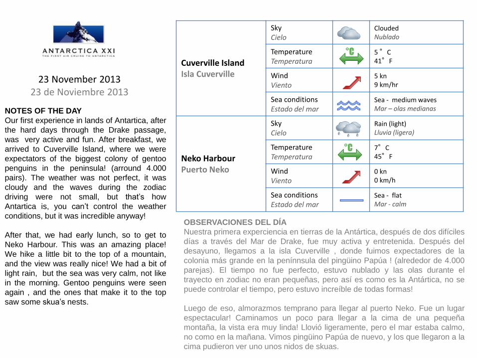
Cuverville Island Isla Cuverville
Sky Cielo
Clouded Nublado
Temperature Temperatura
5 °C 41°F
Wind Viento
5 kn 9 km/hr
Sea conditions Estado del mar
Sea - medium waves Mar – olas medianas
Neko Harbour Puerto Neko
Sky Cielo
Rain (light) Lluvia (ligera)
Temperature Temperatura
7°C 45°F
Wind Viento
0 kn 0 km/h
Sea conditions Estado del mar
Sea - flat Mar - calm
23 November 2013 23 de Noviembre 2013
NOTES OF THE DAY
Our first experience in lands of Antartica, after
the hard days through the Drake passage,
was very active and fun. After breakfast, we
arrived to Cuverville Island, where we were
expectators of the biggest colony of gentoo
penguins in the peninsula! (arround 4.000
pairs). The weather was not perfect, it was
cloudy and the waves during the zodiac
driving were not small, but that’s how
Antartica is, you can’t control the weather
conditions, but it was incredible anyway!
After that, we had early lunch, so to get to
Neko Harbour. This was an amazing place!
We hike a little bit to the top of a mountain,
and the view was really nice! We had a bit of
light rain, but the sea was very calm, not like
in the morning. Gentoo penguins were seen
again , and the ones that make it to the top
saw some skua’s nests.
OBSERVACIONES DEL DÍA
Nuestra primera experciencia en tierras de la Antártica, después de dos difíciles
días a través del Mar de Drake, fue muy activa y entretenida. Después del
desayuno, llegamos a la isla Cuverville , donde fuimos expectadores de la
colonia más grande en la penínnsula del pingüino Papúa ! (alrededor de 4.000
parejas). El tiempo no fue perfecto, estuvo nublado y las olas durante el
trayecto en zodiac no eran pequeñas, pero así es como es la Antártica, no se
puede controlar el tiempo, pero estuvo increíble de todas formas!
Luego de eso, almorazmos temprano para llegar al puerto Neko. Fue un lugar
espectacular! Caminamos un poco para llegar a la cima de una pequeña
montaña, la vista era muy linda! Llovió ligeramente, pero el mar estaba calmo,
no como en la mañana. Vimos pingüino Papúa de nuevo, y los que llegaron a la
cima pudieron ver uno unos nidos de skuas.

Port Lockroy Puerto Lockroy
Sky Cielo
Clouded Nublado
Temperature Temperatura
5°C 41°F
Wind Viento
2 kn 3 km/hr
Sea conditions Estado del mar
Sea - light waves Mar – olas ligeras
NOTES OF THE DAY:
23 November 2013 23 de Noviembre 2013
We finished at 15:00 hrs, and arround
18:30-19:00, we had the last landing of
the day at Port Lockroy, a British base. It
was nice, there’s a museum, and it
transport you to a couple of decads ago,
and shows how people used to eat and
dress during their stay in Antartica (much
different!). Some of us were able to send
some postcards to our family, and to buy
some nice souvenirs. We found some
more gentoos. The day ended with a
good dinner, after a long but incredible
day!.
OBSERVACIONES DEL DÍA
Terminamos a eso de las 15:00 hrs, y alrededor de las 18:30 – 19:00 tuvimos el
último desembarco del día en Puerto Lockroy, una base británica. Lo que fue
una base científica ahora está hecho un museo. Te transporta a un par de
décadas atrás y muestra como la gente se vestía y lo que comían dureante sus
estadías en la Antártica (muy diferente!) Agunos de nosotros enviamos postales
a familia, y compramos algunos souvenirs. También pudimos ver pingüinos
Papúa. El día terminó con una buena cena, después de un largo pero increíble
día!.
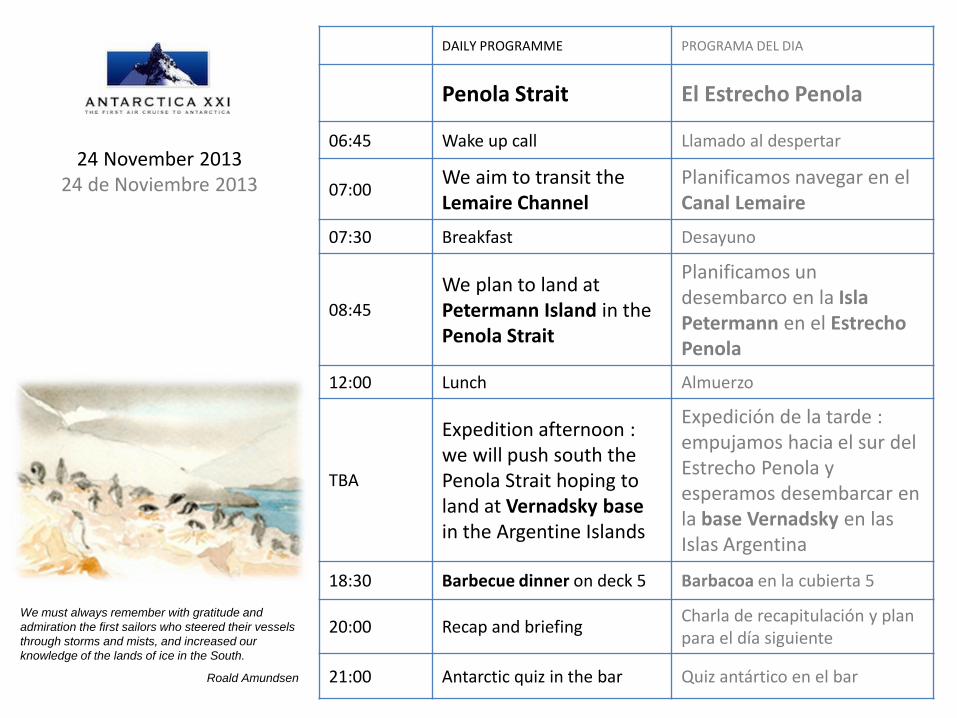
DAILY PROGRAMME PROGRAMA DEL DIA
Penola Strait El Estrecho Penola
06:45 Wake up call Llamado al despertar
07:00 We aim to transit the Lemaire Channel
Planificamos navegar en el Canal Lemaire
07:30 Breakfast Desayuno
08:45
We plan to land at Petermann Island in the Penola Strait
Planificamos un desembarco en la Isla Petermann en el Estrecho Penola
12:00 Lunch Almuerzo
TBA
Expedition afternoon : we will push south the Penola Strait hoping to land at Vernadsky base in the Argentine Islands
Expedición de la tarde : empujamos hacia el sur del Estrecho Penola y esperamos desembarcar en la base Vernadsky en las Islas Argentina
18:30 Barbecue dinner on deck 5 Barbacoa en la cubierta 5
20:00 Recap and briefing Charla de recapitulación y plan para el día siguiente
21:00 Antarctic quiz in the bar Quiz antártico en el bar
24 November 2013 24 de Noviembre 2013
We must always remember with gratitude and
admiration the first sailors who steered their vessels
through storms and mists, and increased our
knowledge of the lands of ice in the South.
Roald Amundsen
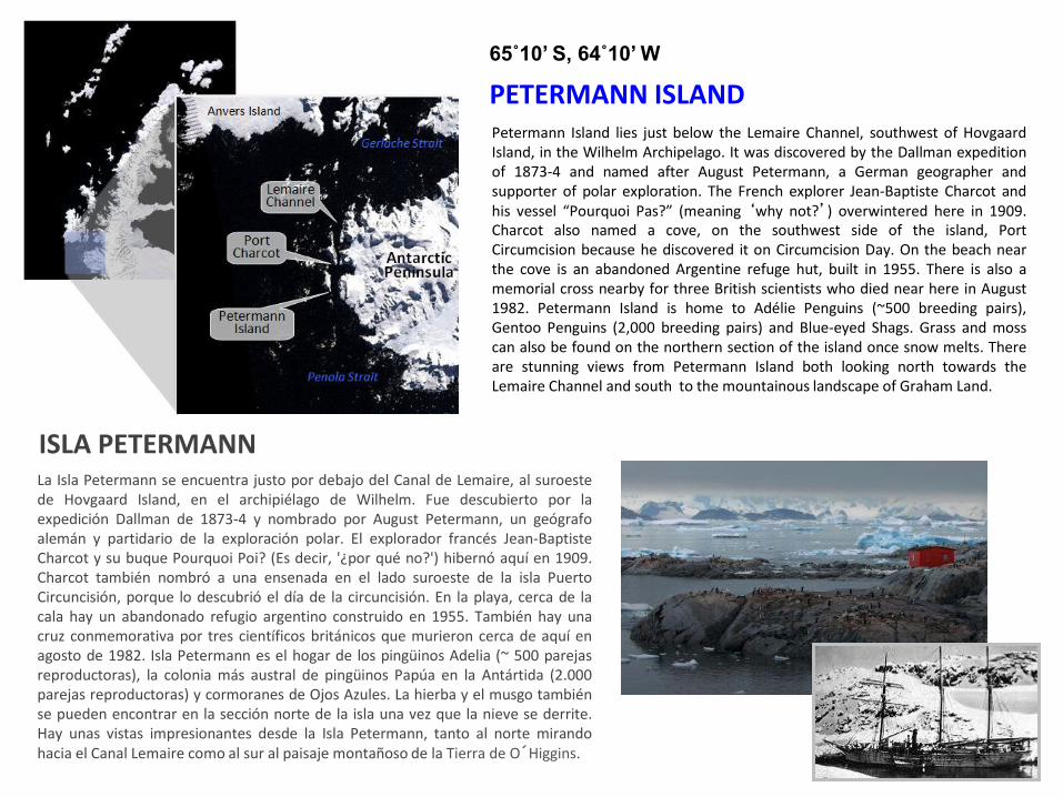
PETERMANN ISLAND
65˚10’ S, 64˚10’ W
Petermann Island lies just below the Lemaire Channel, southwest of Hovgaard Island, in the Wilhelm Archipelago. It was discovered by the Dallman expedition of 1873-4 and named after August Petermann, a German geographer and supporter of polar exploration. The French explorer Jean-Baptiste Charcot and his vessel “Pourquoi Pas?” (meaning ‘why not?’) overwintered here in 1909. Charcot also named a cove, on the southwest side of the island, Port Circumcision because he discovered it on Circumcision Day. On the beach near the cove is an abandoned Argentine refuge hut, built in 1955. There is also a memorial cross nearby for three British scientists who died near here in August 1982. Petermann Island is home to Adélie Penguins (~500 breeding pairs), Gentoo Penguins (2,000 breeding pairs) and Blue-eyed Shags. Grass and moss can also be found on the northern section of the island once snow melts. There are stunning views from Petermann Island both looking north towards the Lemaire Channel and south to the mountainous landscape of Graham Land.
La Isla Petermann se encuentra justo por debajo del Canal de Lemaire, al suroeste de Hovgaard Island, en el archipiélago de Wilhelm. Fue descubierto por la expedición Dallman de 1873-4 y nombrado por August Petermann, un geógrafo alemán y partidario de la exploración polar. El explorador francés Jean-Baptiste Charcot y su buque Pourquoi Poi? (Es decir, '¿por qué no?') hibernó aquí en 1909. Charcot también nombró a una ensenada en el lado suroeste de la isla Puerto Circuncisión, porque lo descubrió el día de la circuncisión. En la playa, cerca de la cala hay un abandonado refugio argentino construido en 1955. También hay una cruz conmemorativa por tres científicos británicos que murieron cerca de aquí en agosto de 1982. Isla Petermann es el hogar de los pingüinos Adelia (~ 500 parejas reproductoras), la colonia más austral de pingüinos Papúa en la Antártida (2.000 parejas reproductoras) y cormoranes de Ojos Azules. La hierba y el musgo también se pueden encontrar en la sección norte de la isla una vez que la nieve se derrite. Hay unas vistas impresionantes desde la Isla Petermann, tanto al norte mirando hacia el Canal Lemaire como al sur al paisaje montañoso de la Tierra de O´Higgins.
ISLA PETERMANN
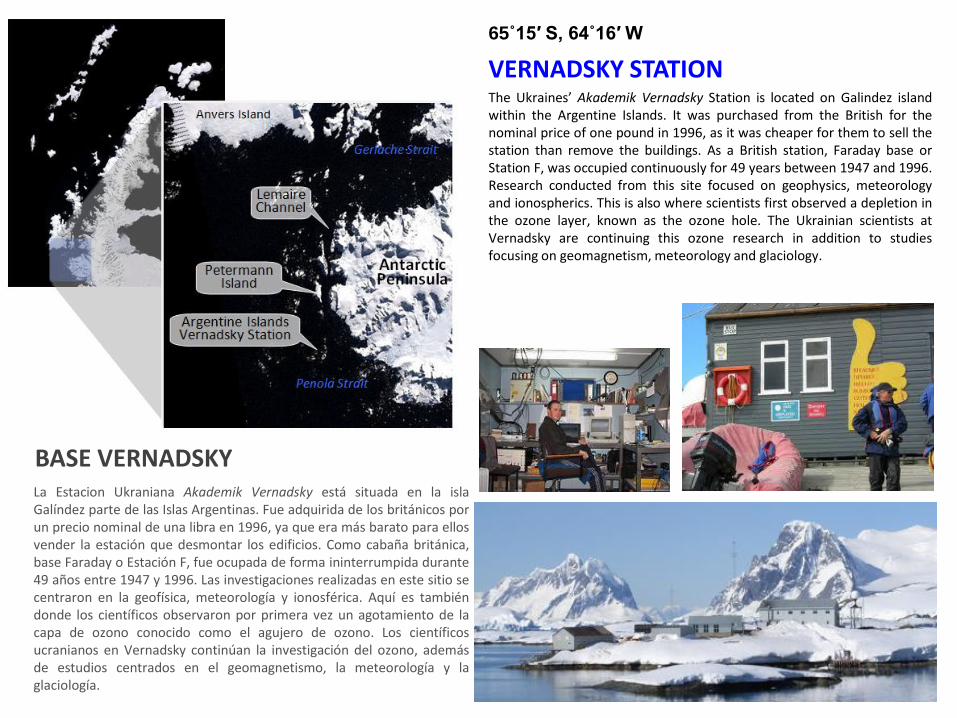
VERNADSKY STATION
65˚15′ S, 64˚16′ W
The Ukraines’ Akademik Vernadsky Station is located on Galindez island within the Argentine Islands. It was purchased from the British for the nominal price of one pound in 1996, as it was cheaper for them to sell the station than remove the buildings. As a British station, Faraday base or Station F, was occupied continuously for 49 years between 1947 and 1996. Research conducted from this site focused on geophysics, meteorology and ionospherics. This is also where scientists first observed a depletion in the ozone layer, known as the ozone hole. The Ukrainian scientists at Vernadsky are continuing this ozone research in addition to studies focusing on geomagnetism, meteorology and glaciology.
La Estacion Ukraniana Akademik Vernadsky está situada en la isla Galíndez parte de las Islas Argentinas. Fue adquirida de los británicos por un precio nominal de una libra en 1996, ya que era más barato para ellos vender la estación que desmontar los edificios. Como cabaña británica, base Faraday o Estación F, fue ocupada de forma ininterrumpida durante 49 años entre 1947 y 1996. Las investigaciones realizadas en este sitio se centraron en la geofísica, meteorología y ionosférica. Aquí es también donde los científicos observaron por primera vez un agotamiento de la capa de ozono conocido como el agujero de ozono. Los científicos ucranianos en Vernadsky continúan la investigación del ozono, además de estudios centrados en el geomagnetismo, la meteorología y la glaciología.
BASE VERNADSKY
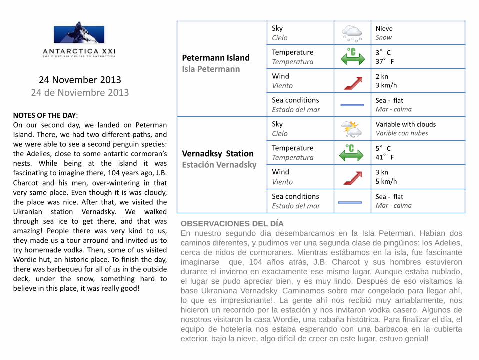
Petermann Island Isla Petermann
Sky Cielo
Nieve Snow
Temperature Temperatura
3°C 37°F
Wind Viento
2 kn 3 km/h
Sea conditions Estado del mar
Sea - flat Mar - calma
Vernadksy Station Estación Vernadsky
Sky Cielo
Variable with clouds Varible con nubes
Temperature Temperatura
5°C 41°F
Wind Viento
3 kn 5 km/h
Sea conditions Estado del mar
Sea - flat Mar - calma
NOTES OF THE DAY: On our second day, we landed on Peterman Island. There, we had two different paths, and we were able to see a second penguin species: the Adelies, close to some antartic cormoran’s nests. While being at the island it was fascinating to imagine there, 104 years ago, J.B. Charcot and his men, over-wintering in that very same place. Even though it is was cloudy, the place was nice. After that, we visited the Ukranian station Vernadsky. We walked through sea ice to get there, and that was amazing! People there was very kind to us, they made us a tour arround and invited us to try homemade vodka. Then, some of us visited Wordie hut, an historic place. To finish the day, there was barbequeu for all of us in the outside deck, under the snow, something hard to believe in this place, it was really good!
24 November 2013 24 de Noviembre 2013
OBSERVACIONES DEL DÍA
En nuestro segundo día desembarcamos en la Isla Peterman. Habían dos
caminos diferentes, y pudimos ver una segunda clase de pingüinos: los Adelies,
cerca de nidos de cormoranes. Mientras estábamos en la isla, fue fascinante
imaginarse que, 104 años atrás, J.B. Charcot y sus hombres estuvieron
durante el invierno en exactamente ese mismo lugar. Aunque estaba nublado,
el lugar se pudo apreciar bien, y es muy lindo. Después de eso visitamos la
base Ukraniana Vernadsky. Caminamos sobre mar congelado para llegar ahí,
lo que es impresionante!. La gente ahí nos recibió muy amablamente, nos
hicieron un recorrido por la estación y nos invitaron vodka casero. Algunos de
nosotros visitaron la casa Wordie, una cabaña histótrica. Para finalizar el día, el
equipo de hotelería nos estaba esperando con una barbacoa en la cubierta
exterior, bajo la nieve, algo difícil de creer en este lugar, estuvo genial!
DAILY PROGRAMME PROGRAMA DEL DIA
Paradise Harbour & Melchior Islands
Puerto Paraiso y las Islas Melchior
07:00 Wake up call Llamado al despertar
07:30 Breakfast Desayuno
08:45
We plan to zodiac cruise at Paradise Harbour, and aim to land
Planificamos un crucero zodiac en Puerto Paraíso, y esperamos desembarcar
12:30 Lunch Almuerzo
14:30 Talk: ‘Antarctic Birds’ by Nigel
Charla : ‘Pájaros Antárticos’ por Nigel
~ 16:00
We aim to zodiac cruise at Melchiors islands in the Dallman Bay
Planificamos un crucero en zodiac en las Islas Melchior en la Bahía Dallman
19:30 Dinner Cena
21:15 Movie in the library Película en la librería
25 November 2013 25 de Noviembre 2013
We must always remember with gratitude and
admiration the first sailors who steered their vessels
through storms and mists, and increased our
knowledge of the lands of ice in the South.
Roald Amundsen
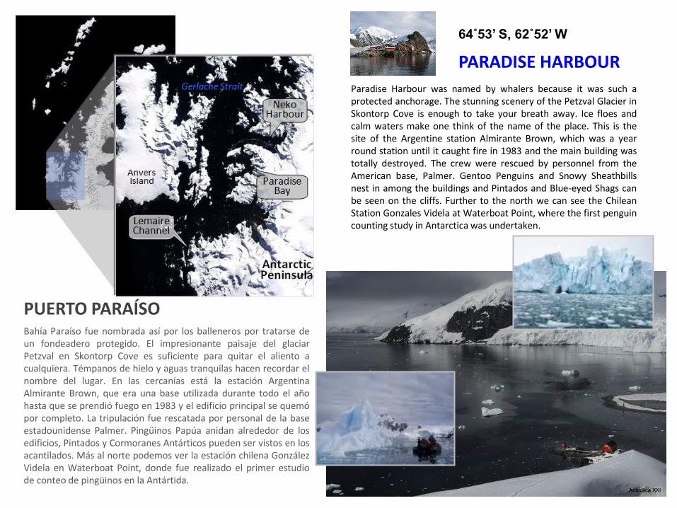
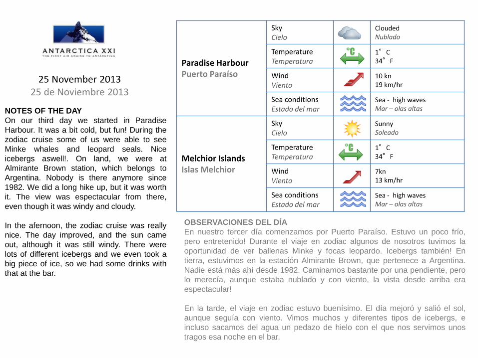
Paradise Harbour was named by whalers because it was such a protected anchorage. The stunning scenery of the Petzval Glacier in Skontorp Cove is enough to take your breath away. Ice floes and calm waters make one think of the name of the place. This is the site of the Argentine station Almirante Brown, which was a year round station until it caught fire in 1983 and the main building was totally destroyed. The crew were rescued by personnel from the American base, Palmer. Gentoo Penguins and Snowy Sheathbills nest in among the buildings and Pintados and Blue-eyed Shags can be seen on the cliffs. Further to the north we can see the Chilean Station Gonzales Videla at Waterboat Point, where the first penguin counting study in Antarctica was undertaken.
Bahía Paraíso fue nombrada así por los balleneros por tratarse de un fondeadero protegido. El impresionante paisaje del glaciar Petzval en Skontorp Cove es suficiente para quitar el aliento a cualquiera. Témpanos de hielo y aguas tranquilas hacen recordar el nombre del lugar. En las cercanías está la estación Argentina Almirante Brown, que era una base utilizada durante todo el año hasta que se prendió fuego en 1983 y el edificio principal se quemó por completo. La tripulación fue rescatada por personal de la base estadounidense Palmer. Pingüinos Papúa anidan alrededor de los edificios, Pintados y Cormoranes Antárticos pueden ser vistos en los acantilados. Más al norte podemos ver la estación chilena González Videla en Waterboat Point, donde fue realizado el primer estudio de conteo de pingüinos en la Antártida.
PARADISE HARBOUR
64˚53’ S, 62˚52’ W
PUERTO PARAÍSO
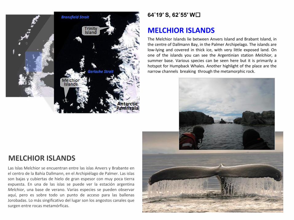
MELCHIOR ISLANDS
64˚19′ S, 62˚55′ W
The Melchior Islands lie between Anvers Island and Brabant Island, in the centre of Dallmann Bay, in the Palmer Archipelago. The islands are low-lying and covered in thick ice, with very little exposed land. On one of the islands you can see the Argentinian station Melchior, a summer base. Various species can be seen here but it is primarily a hotspot for Humpback Whales. Another highlight of the place are the narrow channels breaking through the metamorphic rock.
Las Islas Melchior se encuentran entre las islas Anvers y Brabante en el centro de la Bahía Dallmann, en el Archipiélago de Palmer. Las islas son bajas y cubiertas de hielo de gran espesor con muy poca tierra expuesta. En una de las islas se puede ver la estación argentina Melchior, una base de verano. Varias especies se pueden observar aquí, pero es sobre todo un punto de acceso para las ballenas Jorobadas. Lo más singificativo del lugar son los angostos canales que surgen entre rocas metamórficas.
MELCHIOR ISLANDS
Paradise Harbour Puerto Paraíso
Sky Cielo
Clouded Nublado
Temperature Temperatura
1°C 34°F
Wind Viento
10 kn 19 km/hr
Sea conditions Estado del mar
Sea - high waves Mar – olas altas
Melchior Islands Islas Melchior
Sky Cielo
Sunny Soleado
Temperature Temperatura
1°C 34°F
Wind Viento
7kn 13 km/hr
Sea conditions Estado del mar
Sea - high waves Mar – olas altas
25 November 2013 25 de Noviembre 2013
NOTES OF THE DAY
On our third day we started in Paradise
Harbour. It was a bit cold, but fun! During the
zodiac cruise some of us were able to see
Minke whales and leopard seals. Nice
icebergs aswell!. On land, we were at
Almirante Brown station, which belongs to
Argentina. Nobody is there anymore since
1982. We did a long hike up, but it was worth
it. The view was espectacular from there,
even though it was windy and cloudy.
In the afernoon, the zodiac cruise was really
nice. The day improved, and the sun came
out, although it was still windy. There were
lots of different icebergs and we even took a
big piece of ice, so we had some drinks with
that at the bar.
OBSERVACIONES DEL DÍA
En nuestro tercer día comenzamos por Puerto Paraíso. Estuvo un poco frío,
pero entretenido! Durante el viaje en zodiac algunos de nosotros tuvimos la
oportunidad de ver ballenas Minke y focas leopardo. Icebergs también! En
tierra, estuvimos en la estación Almirante Brown, que pertenece a Argentina.
Nadie está más ahí desde 1982. Caminamos bastante por una pendiente, pero
lo merecía, aunque estaba nublado y con viento, la vista desde arriba era
espectacular!
En la tarde, el viaje en zodiac estuvo buenísimo. El día mejoró y salió el sol,
aunque seguía con viento. Vimos muchos y diferentes tipos de icebergs, e
incluso sacamos del agua un pedazo de hielo con el que nos servimos unos
tragos esa noche en el bar.
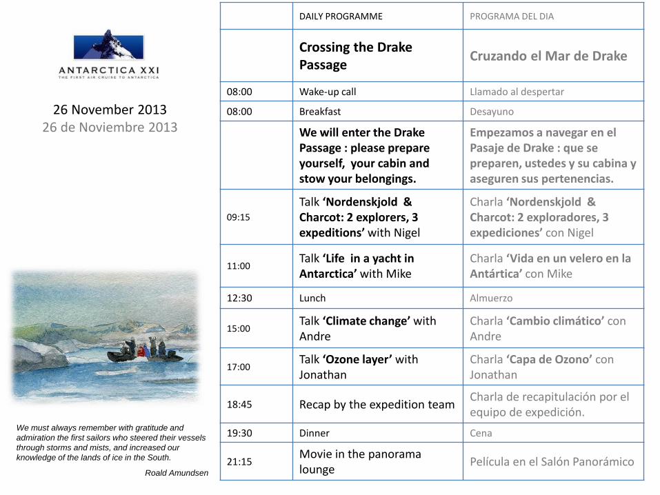
DAILY PROGRAMME PROGRAMA DEL DIA
Crossing the Drake Passage
Cruzando el Mar de Drake
08:00 Wake-up call Llamado al despertar
08:00 Breakfast Desayuno
We will enter the Drake Passage : please prepare yourself, your cabin and stow your belongings.
Empezamos a navegar en el Pasaje de Drake : que se preparen, ustedes y su cabina y aseguren sus pertenencias.
09:15
Talk ‘Nordenskjold & Charcot: 2 explorers, 3 expeditions’ with Nigel
Charla ‘Nordenskjold & Charcot: 2 exploradores, 3 expediciones’ con Nigel
11:00 Talk ‘Life in a yacht in Antarctica’ with Mike
Charla ‘Vida en un velero en la Antártica’ con Mike
12:30 Lunch Almuerzo
15:00 Talk ‘Climate change’ with Andre
Charla ‘Cambio climático’ con Andre
17:00 Talk ‘Ozone layer’ with Jonathan
Charla ‘Capa de Ozono’ con Jonathan
18:45 Recap by the expedition team Charla de recapitulación por el equipo de expedición.
19:30 Dinner Cena
21:15 Movie in the panorama lounge
Película en el Salón Panorámico
26 November 2013 26 de Noviembre 2013
We must always remember with gratitude and
admiration the first sailors who steered their vessels
through storms and mists, and increased our
knowledge of the lands of ice in the South.
Roald Amundsen
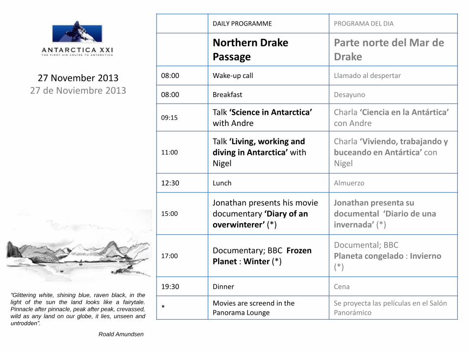
DAILY PROGRAMME PROGRAMA DEL DIA
Northern Drake Passage
Parte norte del Mar de Drake
08:00 Wake-up call Llamado al despertar
08:00 Breakfast Desayuno
09:15 Talk ‘Science in Antarctica’ with Andre
Charla ‘Ciencia en la Antártica’ con Andre
11:00
Talk ‘Living, working and diving in Antarctica’ with Nigel
Charla ‘Viviendo, trabajando y buceando en Antártica’ con Nigel
12:30 Lunch Almuerzo
15:00
Jonathan presents his movie documentary ‘Diary of an overwinterer’ (*)
Jonathan presenta su documental ‘Diario de una invernada’ (*)
17:00 Documentary; BBC Frozen Planet : Winter (*)
Documental; BBC Planeta congelado : Invierno (*)
19:30 Dinner Cena
* Movies are screend in the Panorama Lounge
Se proyecta las películas en el Salón Panorámico
27 November 2013 27 de Noviembre 2013
“Glittering white, shining blue, raven black, in the
light of the sun the land looks like a fairytale.
Pinnacle after pinnacle, peak after peak, crevassed,
wild as any land on our globe, it lies, unseen and
untrodden”.
Roald Amundsen
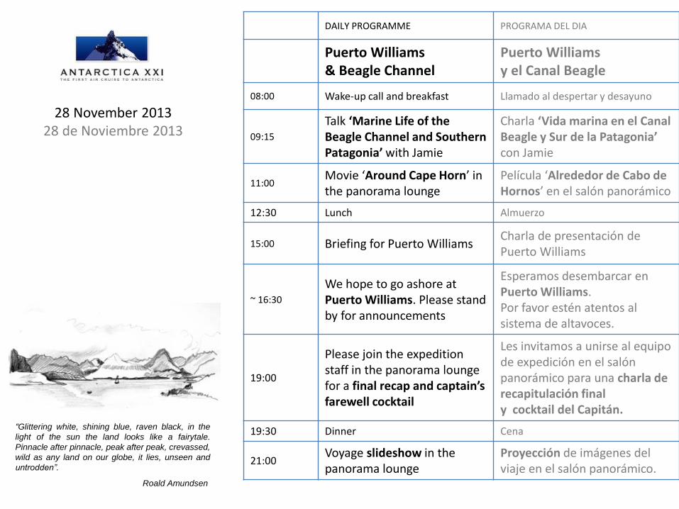
DAILY PROGRAMME PROGRAMA DEL DIA
Puerto Williams & Beagle Channel
Puerto Williams y el Canal Beagle
08:00 Wake-up call and breakfast Llamado al despertar y desayuno
09:15
Talk ‘Marine Life of the Beagle Channel and Southern Patagonia’ with Jamie
Charla ‘Vida marina en el Canal Beagle y Sur de la Patagonia’ con Jamie
11:00 Movie ‘Around Cape Horn’ in the panorama lounge
Película ‘Alrededor de Cabo de Hornos’ en el salón panorámico
12:30 Lunch Almuerzo
15:00 Briefing for Puerto Williams Charla de presentación de Puerto Williams
~ 16:30
We hope to go ashore at Puerto Williams. Please stand by for announcements
Esperamos desembarcar en Puerto Williams. Por favor estén atentos al sistema de altavoces.
19:00
Please join the expedition staff in the panorama lounge for a final recap and captain’s farewell cocktail
Les invitamos a unirse al equipo de expedición en el salón panorámico para una charla de recapitulación final y cocktail del Capitán.
19:30 Dinner Cena
21:00 Voyage slideshow in the panorama lounge
Proyección de imágenes del viaje en el salón panorámico.
28 November 2013 28 de Noviembre 2013
“Glittering white, shining blue, raven black, in the
light of the sun the land looks like a fairytale.
Pinnacle after pinnacle, peak after peak, crevassed,
wild as any land on our globe, it lies, unseen and
untrodden”.
Roald Amundsen
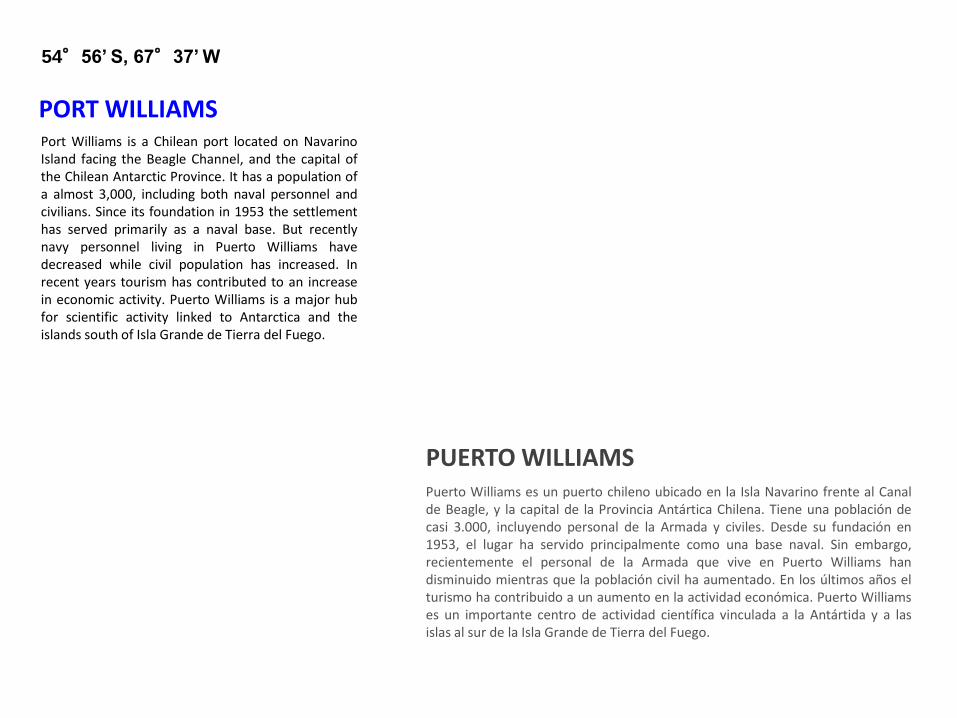
Port Williams is a Chilean port located on Navarino Island facing the Beagle Channel, and the capital of the Chilean Antarctic Province. It has a population of a almost 3,000, including both naval personnel and civilians. Since its foundation in 1953 the settlement has served primarily as a naval base. But recently navy personnel living in Puerto Williams have decreased while civil population has increased. In recent years tourism has contributed to an increase in economic activity. Puerto Williams is a major hub for scientific activity linked to Antarctica and the islands south of Isla Grande de Tierra del Fuego.
PORT WILLIAMS
54°56’ S, 67°37’ W
Puerto Williams es un puerto chileno ubicado en la Isla Navarino frente al Canal de Beagle, y la capital de la Provincia Antártica Chilena. Tiene una población de casi 3.000, incluyendo personal de la Armada y civiles. Desde su fundación en 1953, el lugar ha servido principalmente como una base naval. Sin embargo, recientemente el personal de la Armada que vive en Puerto Williams han disminuido mientras que la población civil ha aumentado. En los últimos años el turismo ha contribuido a un aumento en la actividad económica. Puerto Williams es un importante centro de actividad científica vinculada a la Antártida y a las islas al sur de la Isla Grande de Tierra del Fuego.
PUERTO WILLIAMS
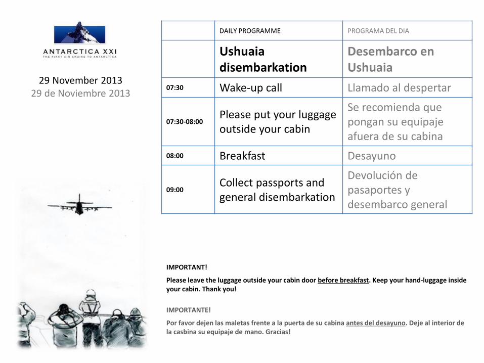
DAILY PROGRAMME PROGRAMA DEL DIA
Ushuaia disembarkation
Desembarco en Ushuaia
07:30 Wake-up call Llamado al despertar
07:30-08:00 Please put your luggage outside your cabin
Se recomienda que pongan su equipaje afuera de su cabina
08:00 Breakfast Desayuno
09:00 Collect passports and general disembarkation
Devolución de pasaportes y desembarco general
IMPORTANT!
Please leave the luggage outside your cabin door before breakfast. Keep your hand-luggage inside your cabin. Thank you!
IMPORTANTE!
Por favor dejen las maletas frente a la puerta de su cabina antes del desayuno. Deje al interior de la casbina su equipaje de mano. Gracias!
29 November 2013 29 de Noviembre 2013
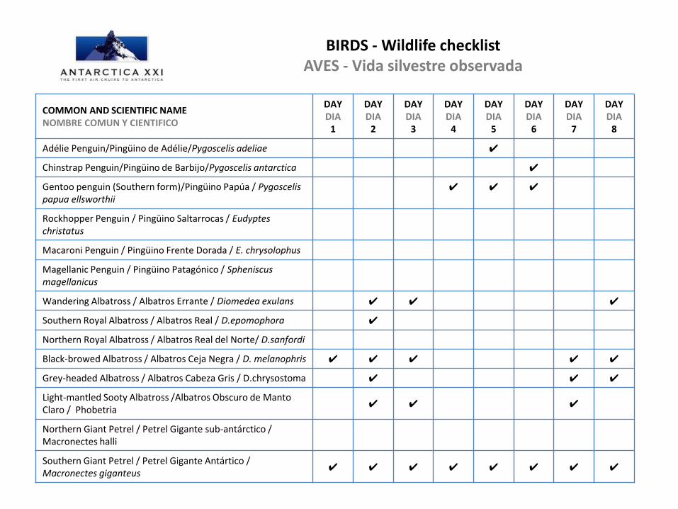
BIRDS - Wildlife checklist AVES - Vida silvestre observada
COMMON AND SCIENTIFIC NAME NOMBRE COMUN Y CIENTIFICO
DAY DIA
1
DAY DIA
2
DAY DIA
3
DAY DIA
4
DAY DIA
5
DAY DIA
6
DAY DIA
7
DAY DIA
8
Adélie Penguin/Pingüino de Adélie/Pygoscelis adeliae ✔
Chinstrap Penguin/Pingüino de Barbijo/Pygoscelis antarctica ✔
Gentoo penguin (Southern form)/Pingüino Papúa / Pygoscelis papua ellsworthii
✔ ✔ ✔
Rockhopper Penguin / Pingüino Saltarrocas / Eudyptes christatus
Macaroni Penguin / Pingüino Frente Dorada / E. chrysolophus
Magellanic Penguin / Pingüino Patagónico / Spheniscus magellanicus
Wandering Albatross / Albatros Errante / Diomedea exulans ✔ ✔ ✔
Southern Royal Albatross / Albatros Real / D.epomophora ✔
Northern Royal Albatross / Albatros Real del Norte/ D.sanfordi
Black-browed Albatross / Albatros Ceja Negra / D. melanophris ✔ ✔ ✔ ✔ ✔
Grey-headed Albatross / Albatros Cabeza Gris / D.chrysostoma ✔ ✔ ✔
Light-mantled Sooty Albatross /Albatros Obscuro de Manto Claro / Phobetria
✔ ✔ ✔
Northern Giant Petrel / Petrel Gigante sub-antárctico / Macronectes halli
Southern Giant Petrel / Petrel Gigante Antártico / Macronectes giganteus
✔ ✔ ✔ ✔ ✔ ✔ ✔ ✔
COMMON AND SCIENTIFIC NAME NOMBRE COMUN Y CIENTIFICO
DAY DIA
1
DAY DIA
2
DAY DIA
3
DAY DIA
4
DAY DIA
5
DAY DIA
6
DAY DIA
7
DAY DIA
8
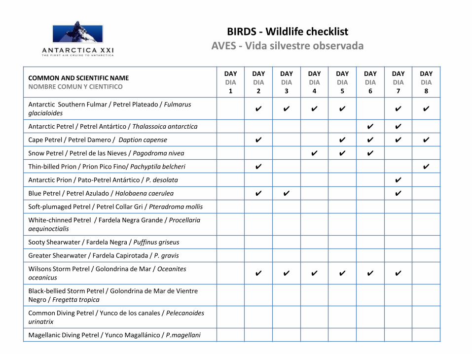
Antarctic Southern Fulmar / Petrel Plateado / Fulmarus glacialoides
✔ ✔ ✔ ✔ ✔ ✔
Antarctic Petrel / Petrel Antártico / Thalassoica antarctica ✔ ✔
Cape Petrel / Petrel Damero / Daption capense ✔ ✔ ✔ ✔ ✔
Snow Petrel / Petrel de las Nieves / Pagodroma nivea ✔ ✔ ✔
Thin-billed Prion / Prion Pico Fino/ Pachyptila belcheri ✔ ✔
Antarctic Prion / Pato-Petrel Antártico / P. desolata ✔
Blue Petrel / Petrel Azulado / Halobaena caerulea ✔ ✔ ✔
Soft-plumaged Petrel / Petrel Collar Gri / Pteradroma mollis
White-chinned Petrel / Fardela Negra Grande / Procellaria aequinoctialis
Sooty Shearwater / Fardela Negra / Puffinus griseus
Greater Shearwater / Fardela Capirotada / P. gravis
Wilsons Storm Petrel / Golondrina de Mar / Oceanites oceanicus
✔ ✔ ✔ ✔ ✔ ✔
Black-bellied Storm Petrel / Golondrina de Mar de Vientre Negro / Fregetta tropica
Common Diving Petrel / Yunco de los canales / Pelecanoides urinatrix
Magellanic Diving Petrel / Yunco Magallánico / P.magellani
BIRDS - Wildlife checklist AVES - Vida silvestre observada
COMMON AND SCIENTIFIC NAME NOMBRE COMUN Y CIENTIFICO
DAY DIA
1
DAY DIA
2
DAY DIA
3
DAY DIA
4
DAY DIA
5
DAY DIA
6
DAY DIA
7
DAY DIA
8
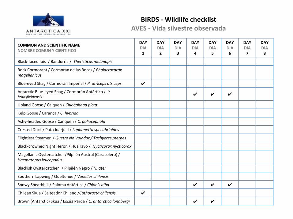
Black-faced Ibis / Bandurria / Theristicus melanopis
Rock Cormorant / Cormorán de las Rocas / Phalacrocorax magellanicus
Blue-eyed Shag / Cormorán Imperial / P. atriceps atriceps ✔
Antarctic Blue-eyed Shag / Cormorán Antártico / P. bransfieldensis
✔ ✔ ✔
Upland Goose / Caiquen / Chloephaga picta
Kelp Goose / Caranca / C. hybrida
Ashy-headed Goose / Canquen / C. poliocephala
Crested Duck / Pato Juarjual / Lophonetta specubrioides
Flightless Steamer / Quetro No Volador / Tachyeres pternes
Black-crowned Night Heron / Huairavo / Nycticorax nycticorax
Magellanic Oystercatcher /Pilpilén Austral (Caracolero) / Haematopus leucopodus
Blackish Oystercatcher / Pilpilén Negro / H. ater
Southern Lapwing / Queltehue / Vanellus chilensis
Snowy Sheathbill / Paloma Antártica / Chionis alba ✔ ✔ ✔
Chilean Skua / Salteador Chileno /Catharacta chilensis ✔
Brown (Antarctic) Skua / Escúa Parda / C. antarctica lonnbergi ✔ ✔
BIRDS - Wildlife checklist AVES - Vida silvestre observada
COMMON AND SCIENTIFIC NAME NOMBRE COMUN Y CIENTIFICO
DAY DIA
1
DAY DIA
2
DAY DIA
3
DAY DIA
4
DAY DIA
5
DAY DIA
6
DAY DIA
7
DAY DIA
8
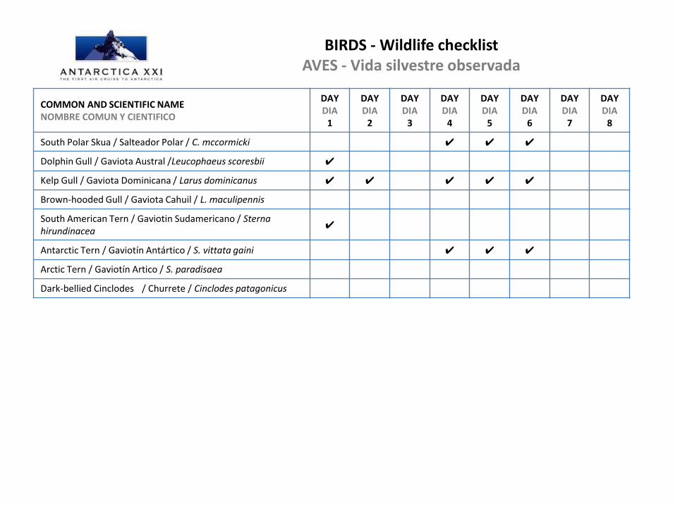
South Polar Skua / Salteador Polar / C. mccormicki ✔ ✔ ✔
Dolphin Gull / Gaviota Austral /Leucophaeus scoresbii ✔
Kelp Gull / Gaviota Dominicana / Larus dominicanus ✔ ✔ ✔ ✔ ✔
Brown-hooded Gull / Gaviota Cahuil / L. maculipennis
South American Tern / Gaviotin Sudamericano / Sterna hirundinacea
✔
Antarctic Tern / Gaviotín Antártico / S. vittata gaini ✔ ✔ ✔
Arctic Tern / Gaviotín Artico / S. paradisaea
Dark-bellied Cinclodes / Churrete / Cinclodes patagonicus
BIRDS - Wildlife checklist AVES - Vida silvestre observada
MAMMALS - Wildlife checklist MAMIFEROS - Vida silvestre observada
COMMON AND SCIENTIFIC NAME NOMBRE COMUN Y CIENTIFICO
DAY DIA
1
DAY DIA
2
DAY DIA
3
DAY DIA
4
DAY DIA
5
DAY DIA
6
DAY DIA
7
DAY DIA
8
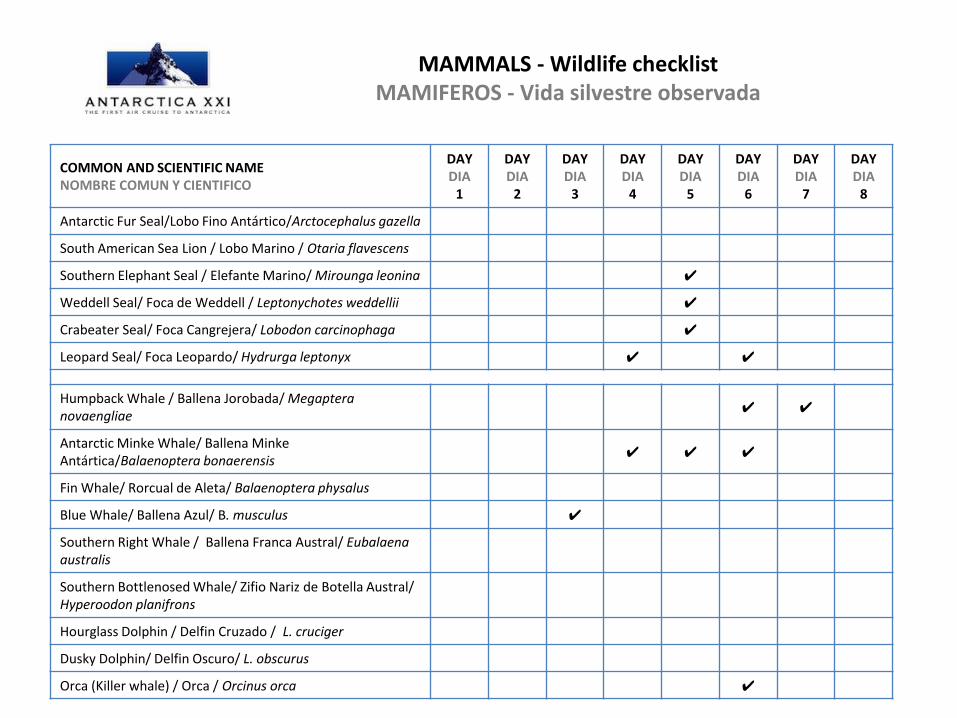
Antarctic Fur Seal/Lobo Fino Antártico/Arctocephalus gazella
South American Sea Lion / Lobo Marino / Otaria flavescens
Southern Elephant Seal / Elefante Marino/ Mirounga leonina ✔
Weddell Seal/ Foca de Weddell / Leptonychotes weddellii ✔
Crabeater Seal/ Foca Cangrejera/ Lobodon carcinophaga ✔
Leopard Seal/ Foca Leopardo/ Hydrurga leptonyx ✔ ✔
Humpback Whale / Ballena Jorobada/ Megaptera novaengliae
✔ ✔
Antarctic Minke Whale/ Ballena Minke Antártica/Balaenoptera bonaerensis
✔ ✔ ✔
Fin Whale/ Rorcual de Aleta/ Balaenoptera physalus
Blue Whale/ Ballena Azul/ B. musculus ✔
Southern Right Whale / Ballena Franca Austral/ Eubalaena australis
Southern Bottlenosed Whale/ Zifio Nariz de Botella Austral/ Hyperoodon planifrons
Hourglass Dolphin / Delfin Cruzado / L. cruciger
Dusky Dolphin/ Delfin Oscuro/ L. obscurus
Orca (Killer whale) / Orca / Orcinus orca ✔
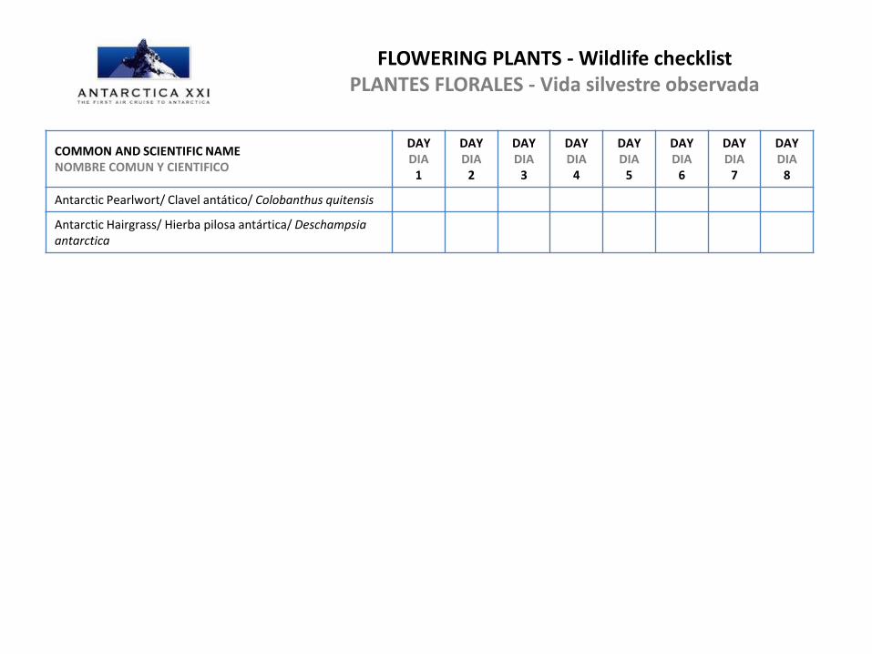
FLOWERING PLANTS - Wildlife checklist PLANTES FLORALES - Vida silvestre observada
COMMON AND SCIENTIFIC NAME NOMBRE COMUN Y CIENTIFICO
DAY DIA
1
DAY DIA
2
DAY DIA
3
DAY DIA
4
DAY DIA
5
DAY DIA
6
DAY DIA
7
DAY DIA
8
Antarctic Pearlwort/ Clavel antático/ Colobanthus quitensis
Antarctic Hairgrass/ Hierba pilosa antártica/ Deschampsia antarctica
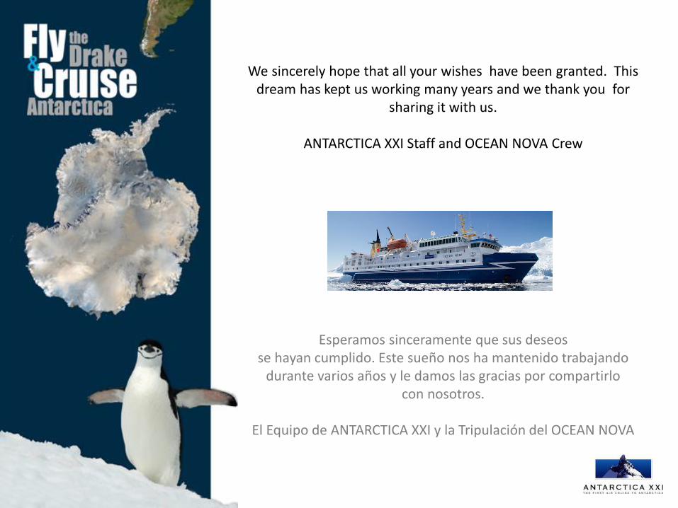
We sincerely hope that all your wishes have been granted. This dream has kept us working many years and we thank you for
sharing it with us.
ANTARCTICA XXI Staff and OCEAN NOVA Crew
Esperamos sinceramente que sus deseos se hayan cumplido. Este sueño nos ha mantenido trabajando
durante varios años y le damos las gracias por compartirlo con nosotros.
El Equipo de ANTARCTICA XXI y la Tripulación del OCEAN NOVA
w w w . a n t a r c t i c a x x i . c o m