angelfest music and arts festival
TRANSCRIPT
LOS ANGELES COUNTY DRAINAGE AREA SEPULVEDA DAM BASIN ANGELFEST MUSIC AND ARTS FESTIVAL
Draft Environmental Assessment Draft Finding of No Significant Impact Prepared by US Army Corps of Engineers Los Angeles District 915 Wilshire Blvd. Los Angeles, California 90017-3401 With Technical Assistance by City of Los Angeles Department of Recreation and Parks April 2016


AngelFest i 150107
Draft Environmental Assessment April 2016
TABLE OF CONTENTS Draft Environmental Assessment
Page
Chapter 1, Introduction ..................................................................................................................... 1-1 1.1 Proposed Project Site ....................................................................................................... 1-2
1.1.1 Woodley Park .................................................................................................... 1-7 1.1.2 Sepulveda Basin Cricket Fields ......................................................................... 1-8 1.1.3 Woodley Park Archery Range ........................................................................... 1-8 1.1.4 Sepulveda Basin Wildlife Area .......................................................................... 1-8 1.1.5 Japanese Garden................................................................................................. 1-8
1.2 Parking Areas .................................................................................................................. 1-8 1.2.1 Woodley Lakes Municipal Golf Course ............................................................ 1-9 1.2.2 Balboa Sports Center ......................................................................................... 1-9 1.2.3 Sepulveda Basin Sports Complex ...................................................................... 1-9 1.2.4 Van Nuys Model Airplane Field ........................................................................ 1-9 1.2.5 Orange Line Parking Lots .................................................................................. 1-9 1.2.6 Other Satellite Parking Areas (Outside the Basin) ............................................. 1-9
1.3 Surrounding Land Uses ................................................................................................. 1-10 1.4 Authority........................................................................................................................ 1-10 1.5 Background .................................................................................................................... 1-11 1.6 Purpose and Need .......................................................................................................... 1-11 1.7 RAP’s Project Objectives .............................................................................................. 1-12
Chapter 2, Alternatives ...................................................................................................................... 2-1 2.1 Alternatives Eliminated From Consideration .................................................................. 2-1
2.1.1 Alternate Locations in the Basin ........................................................................ 2-1 2.1.2 Two Day Event in Sepulveda Basin .................................................................. 2-2 2.1.3 Alternate Locations Outside of the Basin .......................................................... 2-3
2.2 Alternatives Carried Forward for Comparison .............................................................. 2-11 2.2.1 Alternative 2 .................................................................................................... 2-11 2.2.2 No Action Alternative ...................................................................................... 2-11
2.3 Proponent’s Preferred Alternative ................................................................................. 2-12 2.3.1 Festival Characteristics .................................................................................... 2-13 2.3.2 Festival Production Schedule ........................................................................... 2-30 2.3.3 Pre-Festival Site Preparation Activities ........................................................... 2-31 2.3.4 Post-Festival Restoration ................................................................................. 2-34
Chapter 3, Baseline Conditions ......................................................................................................... 3-1 3.1 Physical Land Resources ................................................................................................. 3-1
3.1.1 Earthquake Faults .............................................................................................. 3-1 3.2 Water Resources .............................................................................................................. 3-1 3.3 Air Quality ....................................................................................................................... 3-2
3.3.1 Local Air Quality ............................................................................................... 3-2
Table of Contents
Page
AngelFest ii 150107
Draft Environmental Assessment April 2016
3.3.2 Greenhouse Gas Emissions ................................................................................ 3-4 3.4 Climate Change ............................................................................................................... 3-5 3.5 Noise ................................................................................................................................ 3-6
3.5.1 Existing Noise Environment .............................................................................. 3-7 3.6 Biological Resources ..................................................................................................... 3-11
3.6.1 Vegetation Communities ................................................................................. 3-12 3.6.2 Common Wildlife ............................................................................................ 3-13 3.6.3 Federally Listed Species .................................................................................. 3-14 3.6.4 Jurisdictional Resources ................................................................................... 3-15 3.6.5 Wildlife Corridors ............................................................................................ 3-15 3.6.6 Protected Trees ................................................................................................ 3-15
3.7 Cultural Resources ......................................................................................................... 3-16 3.7.1 Known Cultural Resources .............................................................................. 3-16
3.8 Hazardous Materials and Wastes ................................................................................... 3-17 3.9 Socioeconomics and Environmental Justice .................................................................. 3-18 3.10 Transportation and Traffic ............................................................................................. 3-19 3.11 Utilities .......................................................................................................................... 3-21 3.12 Aesthetics ...................................................................................................................... 3-21 3.13 Recreation Resources .................................................................................................... 3-22 3.14 Public Health and Safety ............................................................................................... 3-22
3.14.1 Floodplain Management .................................................................................. 3-23 3.14.2 Emergency Responders .................................................................................... 3-24
3.15 Sustainability ................................................................................................................. 3-24
Chapter 4, Alternatives Impacts Assessment .................................................................................. 4-1 4.1 Physical Land Resources ................................................................................................. 4-1
4.1.1 Thresholds of Significance ................................................................................ 4-1 4.1.2 Proponent’s Preferred Alternative ..................................................................... 4-1 4.1.3 Alternative 2 ...................................................................................................... 4-2 4.1.4 No Action Alternative ........................................................................................ 4-3 4.1.5 Environmental Commitments ............................................................................ 4-3
4.2 Water Resources .............................................................................................................. 4-3 4.2.1 Thresholds of Significance ................................................................................ 4-3 4.2.2 Proponent’s Preferred Alternative ..................................................................... 4-4 4.2.3 Alternative 2 ...................................................................................................... 4-5 4.2.4 No Action Alternative ........................................................................................ 4-5 4.2.5 Environmental Commitments ............................................................................ 4-6
4.3 Air Quality ....................................................................................................................... 4-7 4.3.1 Thresholds of Significance ................................................................................ 4-7 4.3.2 Proponent’s Preferred Alternative ..................................................................... 4-7 4.3.3 Alternative 2 .................................................................................................... 4-12 4.3.4 No Action Alternative ...................................................................................... 4-12 4.3.5 Environmental Commitments .......................................................................... 4-12
4.4 Noise .............................................................................................................................. 4-13 4.4.1 Thresholds of Significance .............................................................................. 4-13 4.4.2 Proponent’s Preferred Alternative ................................................................... 4-13 4.4.3 Alternative 2 .................................................................................................... 4-25 4.4.4 No Action Alternative ...................................................................................... 4-25 4.4.5 Environmental Commitments .......................................................................... 4-25
4.5 Biological Resources ..................................................................................................... 4-27 4.5.1 Thresholds of Significance .............................................................................. 4-27 4.5.2 Proponent’s Preferred Alternative ................................................................... 4-27
Table of Contents
Page
AngelFest iii 150107
Draft Environmental Assessment April 2016
4.5.3 Alternative 2 .................................................................................................... 4-32 4.5.4 No Action Alternative ...................................................................................... 4-32 4.5.5 Environmental Commitments .......................................................................... 4-33
4.6 Cultural Resources ......................................................................................................... 4-35 4.6.1 Thresholds of Significance .............................................................................. 4-35 4.6.2 Proponent’s Preferred Alternative ................................................................... 4-36 4.6.3 Alternative 2 .................................................................................................... 4-36 4.6.4 No Action Alternative ...................................................................................... 4-36 4.6.5 Environmental Commitments .......................................................................... 4-36
4.7 Hazardous and Toxic Waste Materials .......................................................................... 4-37 4.7.1 Thresholds of Significance .............................................................................. 4-37 4.7.2 Proponent’s Preferred Alternative ................................................................... 4-37 4.7.3 Alternative 2 .................................................................................................... 4-38 4.7.4 No Action Alternative ...................................................................................... 4-38 4.7.5 Environmental Commitments .......................................................................... 4-38
4.8 Socioeconomics and Environmental Justice .................................................................. 4-39 4.8.1 Thresholds of Significance .............................................................................. 4-39 4.8.2 Proponent’s Preferred Alternative ................................................................... 4-39 4.8.3 Alternative 2 .................................................................................................... 4-39 4.8.4 No Action Alternative ...................................................................................... 4-40
4.9 Traffic and Transportation ............................................................................................. 4-40 4.9.1 Thresholds of Significance .............................................................................. 4-40 4.9.2 Proponent’s Preferred Alternative ................................................................... 4-40 4.9.3 Alternative 2 .................................................................................................... 4-44 4.9.4 No Action Alternative ...................................................................................... 4-44 4.9.5 Environmental Commitments .......................................................................... 4-44
4.10 Utilities .......................................................................................................................... 4-45 4.10.1 Thresholds of Significance .............................................................................. 4-45 4.10.2 Proponent’s Preferred Alternative ................................................................... 4-45 4.10.3 Alternative 2 .................................................................................................... 4-46 4.10.4 No Action Alternative ...................................................................................... 4-46
4.11 Aesthetics ...................................................................................................................... 4-46 4.11.1 Thresholds of Significance .............................................................................. 4-46 4.11.2 Proponent’s Preferred Alternative ................................................................... 4-47 4.11.3 Alternative 2 .................................................................................................... 4-48 4.11.4 No Action Alternative ...................................................................................... 4-48 4.11.5 Environmental Commitments .......................................................................... 4-48
4.12 Recreation ...................................................................................................................... 4-48 4.12.1 Thresholds of Significance .............................................................................. 4-48 4.12.2 Proponent’s Preferred Alternative ................................................................... 4-49 4.12.3 Alternative 2 .................................................................................................... 4-52 4.12.4 No Action Alternative ...................................................................................... 4-52 4.12.5 Environmental Commitments .......................................................................... 4-52
4.13 Public Health and Safety ............................................................................................... 4-52 4.13.1 Thresholds of Significance .............................................................................. 4-52 4.13.2 Proponent’s Preferred Alternative ................................................................... 4-53 4.13.3 Alternative 2 .................................................................................................... 4-54 4.13.4 No Action Alternative ...................................................................................... 4-55 4.13.5 Environmental Commitments .......................................................................... 4-55
4.14 Sustainability ................................................................................................................. 4-56 4.14.1 Thresholds of Significance .............................................................................. 4-56 4.14.2 Proponent’s Preferred Alternative ................................................................... 4-56

Table of Contents
Page
AngelFest iv 150107
Draft Environmental Assessment April 2016
4.14.3 Alternative 2 .................................................................................................... 4-58 4.14.4 No Action Alternative ...................................................................................... 4-58
4.15 Cumulative Impacts ....................................................................................................... 4-58 4.15.1 Past Actions ..................................................................................................... 4-58 4.15.2 Present Conditions ........................................................................................... 4-59 4.15.3 Future Actions .................................................................................................. 4-59
Chapter 5, Public Involvement, Coordination, and Consultation ................................................. 5-1 5.1 Project Delivery Team ..................................................................................................... 5-1 5.2 Agency Coordination ....................................................................................................... 5-1 5.3 Institutional Involvement ................................................................................................. 5-2 5.4 Public Involvement .......................................................................................................... 5-2
Chapter 6, Environmental Laws, Regulations, and Policy Compliance ....................................... 6-1 6.1 Federal ............................................................................................................................. 6-1
National Environmental Policy Act (42 U.S.C. §4321 et seq.) ....................................... 6-1 U.S. Fish and Wildlife Coordination Act (16 U.S.C. § 661 et seq.) ................................ 6-1 Endangered Species Act (16 U.S.C. § 1531 et seq.) ........................................................ 6-1 Migratory Bird Treaty Act (16 U.S.C. §703, et seq.) ...................................................... 6-2 Clean Water Act (33 U.S.C. §1251 et seq.) ..................................................................... 6-2 Clean Air Act (42 U.S.C. §7401 et seq.) ......................................................................... 6-3 Noise Control Act of 1972 (42 U.S.C. §4901 et seq., as amended) ................................ 6-3 National Historic Preservation Act (54 U.S.C. §300101 et seq.) .................................... 6-3 Archaeological Resources Protection Act (16 U.S.C. §770aa et seq.) ............................ 6-4 National Trails System Act .............................................................................................. 6-4 Occupational Safety and Health Administration ............................................................. 6-5 Executive Order (EO) 11514, Protection and Enhancement of Environmental
Quality, amended by Executive Order 11991, Relating to Protection and Enhancement of Environmental Quality ............................................................ 6-5
Executive Order 11988 Floodplain Management (as amended/modified by EO 13960) ................................................................................................................ 6-5
Executive Order 12088, Federal Compliance with Pollution Control Standards ............ 6-6 Executive Order 12898 Environmental Justice ............................................................... 6-6 Executive Order 13045 Protection of Children from Environmental Health Risks
and Safety Risks ................................................................................................. 6-6 Executive Order 13653, Preparing the United States for the Impacts of Climate
Change ............................................................................................................... 6-7
Chapter 7, List of Preparers ............................................................................................................. 7-1 List of Reviewers ....................................................................................................................... 7-1
U.S. Army Corps of Engineers ........................................................................................ 7-1
Chapter 8, References ........................................................................................................................ 8-1
Table of Contents
Page
AngelFest v 150107
Draft Environmental Assessment April 2016
Appendices
A: Air Quality/Greenhouse Gas Modeling B: Noise Modeling C: Traffic Management Plan D: Environmental Commitments
Figures
1 Regional Location Map ................................................................................................................. 1-3 2 Sepulveda Basin Recreational Amenities ...................................................................................... 1-4 3 Proposed Project Site Boundary .................................................................................................... 1-5 4 Conceptual Traffic Management Plan ........................................................................................... 1-6 5 Festival Site Stage Areas ............................................................................................................. 2-16 6 Festival Site Plan ......................................................................................................................... 2-17 7 Fencing ........................................................................................................................................ 2-24 8 Decibel Scale and Common Noise Sources .................................................................................. 3-8 9 Long-Term Noise Monitoring Locations ...................................................................................... 3-9 10 Nearest Off-Site Sensitive Receptor Locations ........................................................................... 4-20
Tables
1 Vehicle Parking Locations .......................................................................................................... 2-29 2 Air Quality Data Summary (2012 – 2014) For Project Area ........................................................ 3-3 3 South Coast Air Basin Attainment Status ..................................................................................... 3-4 4 Long-Term Ambient Noise measurement results ....................................................................... 3-10 5 Ambient Noise Levels in the Wildlife Area ................................................................................ 3-11 6 Proposal Site Demographics ....................................................................................................... 3-19 7 Roadways and Traffic Volumes .................................................................................................. 3-20 8 Public Services in the Vicinity of the Basin ................................................................................ 3-25 9 De Minimis Thresholds ................................................................................................................. 4-8 10 Proposed Project Annual Criteria Pollutant Emissions (Tons per Year) ...................................... 4-9 11 Proposed Project Annual GHG Emissions (Metric Tons Per Year) ........................................... 4-11 12 Noise Emission Reference Levels and Usage Factors ................................................................ 4-15 13 Construction Noise Levels .......................................................................................................... 4-16 14 Noise Levels from Outdoor Stage Sound Systems...................................................................... 4-21 15 Noise Levels Increase Over Ambient Condition ......................................................................... 4-22

AngelFest 1-1 150107
Environmental Assessment
CHAPTER 1
Introduction
The U.S. Army Corps of Engineers (Corps) is in receipt of a request by the City of Los Angeles Department of Recreation and Parks (RAP), the recreational lessee at Sepulveda Recreation Area at the Sepulveda Dam Basin (Basin) for a proposed special event entitled AngelFest (Festival), to be managed by Make Good Group. Pursuant to 36 Code of Federal Regulations (C.F.R.) Section 327.21, the Corps is authorized to approve special events at its water resources development projects. Under this authority, special events at Corps projects are prohibited unless written permission has been granted by the District Commander. An appropriate fee may be charged for an event under the authority of Section 327.23. Consistent with the C.F.R. and RAP’s lease, the public shall not be charged any fee by the sponsor of such event unless the District Commander has approved in writing (and the sponsor has properly posted) the proposed schedule of fees. The District Commander has authority to revoke permission, require removal of any equipment, and require restoration of an area to pre-event condition, upon failure of the sponsor to comply with terms and conditions of the permission or these regulations. RAP has requested such permission from the District Commander for this special event. Under the terms of RAP’s recreation lease with the Corps, any special event exceeding 1,000 people requires individual permission from the Corps. Special events with more than 5,000 people or which include activities not already evaluated in the Corps’ 2011 Sepulveda Dam Basin Master Plan and Environmental Assessment (EA) are subject to evaluation in an event-specific National Environmental Policy Act (NEPA) document. Special events must also comply with the Basin Master Plan Appendix A5: Policy on Special Events at the Sepulveda Dam Basin. If a proposed event does not comply with these conditions, the Corps may consider a waiver of the Special Events Policy. The Basin is a federally authorized flood risk management project constructed, operated, and maintained by the Corps. Its primary purpose is to provide flood risk management for the residents of Los Angeles County residing downstream of Sepulveda Dam. The Corps will review RAP’s request in light of Basin’s primary purpose of flood risk management, applicable Federal laws, and Corps regulations and policies in assessing whether the proposed event is a compatible use with Corps’ operations and land use guidelines/policies, and whether it is the public interest.
Chapter 1: Introduction
AngelFest 1-2 150107
Draft Environmental Assessment April 2016
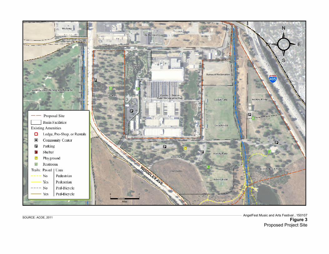
The Corps has prepared this Draft EA to evaluate the potential impacts of the event as proposed by RAP, which is described here as the Proponent’s Preferred Alternative, along with other alternatives including the No Action Alternative. This Draft EA has been prepared pursuant to NEPA (42 United States Code 4321 et seq.), Council on Environmental Quality (CEQ) regulations published at 40 Code of Federal Regulations (CFR) Part 1500 et seq., the Corps’ Engineering Regulation 200-2-2, Procedures for Implementing NEPA (33 CFR Part 230), other environmental laws, Executive Orders, and Corps regulations and policies. This Draft EA is being circulated to the public and relevant agencies for a 30-day period. The Sepulveda Dam Basin Master Plan and Environmental Assessment (2011) describes the baseline conditions for the natural and human resources within the Basin. Those portions of Chapters 3 and 4 of the Master Plan EA that describe baseline environmental conditions relevant to the alternatives are incorporated here by reference. 1.1 Proposed Project Site The Sepulveda Dam Flood Control Basin (Basin) is located in the San Fernando Valley about 17 miles northwest of downtown Los Angeles and two miles southwest of the community of Van Nuys, within the City of Los Angeles, Los Angeles County, California. Regional access is provided by two freeways, the Ventura Freeway (U.S. Highway 101[US-101]) and the San Diego Freeway (Interstate 405 [I-405]), and lies northwest of the junction of these freeways. Local access is provided from Victory Boulevard, Woodley Avenue, Balboa Boulevard, and Burbank Boulevard (see Figure 1). The Proposed Project Site would encompass approximately 195 acres within the Basin and would include Woodley Park (I and II) and activity fields, the cricket fields, the archery range, the Japanese Garden, and the northern landscaped part of the Sepulveda Basin Wildlife Area (Woodley III) (Figure 2 and Figure 3). Parking areas within the Basin would include the Sepulveda Basin Sports Complex, Woodley Lakes Municipal Golf Course, Balboa Sports Center, model airplane field (north of the airstrip), and the Orange Line parking lot at Victory and Balboa. Parking areas outside the Basin and outside Corps jurisdiction include the Orange Line parking lot at Erwin Street, the Van Nuys Flyaway lot, Pierce College, and the paved parking lots located northeast of the intersection of Balboa Boulevard and Stagg Street, south of San Fernando Valley Parole Unit. The Festival and parking areas within Corps’ jurisdiction are collectively referred to as the Proposed Project Site (see Figure 4).
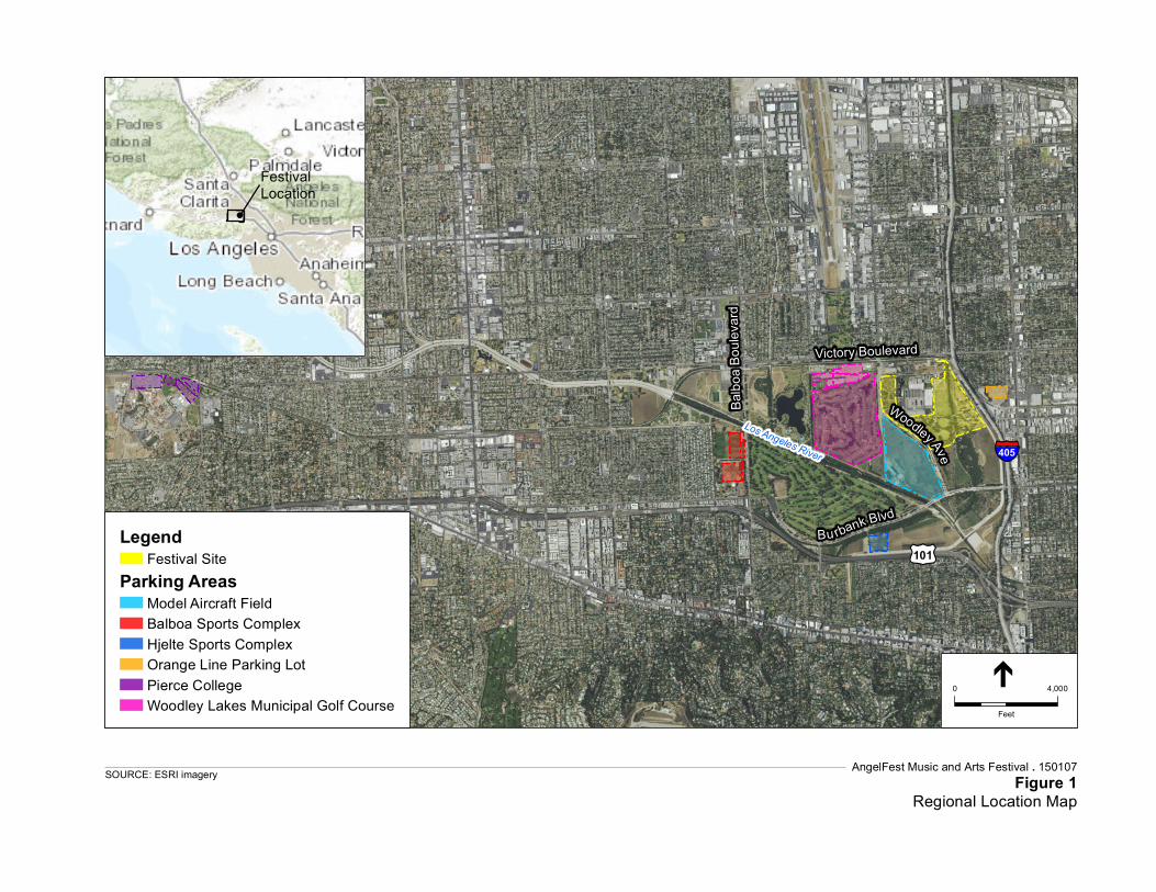
Service Layer Credits: Sources: Esri, HERE,DeLorme, Intermap, increment P Corp.,GEBCO, USGS, FAO, NPS, NRCAN,GeoBase, IGN, Kadaster NL, OrdnanceSurvey, Esri Japan, METI, Esri China (HongKong), swisstopo, MapmyIndia, ©OpenStreetMap contributors, and the GISUser CommunitySource: Esri, DigitalGlobe, GeoEye, EarthstarGeographics, CNES/Airbus DS, USDA,USGS, AEX, Getmapping, Aerogrid, IGN, IGP,swisstopo, and the GIS User Community
AngelFest Music and Arts Festival . 150107Figure 1
Regional Location MapSOURCE: ESRI imagery
LegendFestival Site
Parking AreasModel Aircraft FieldBalboa Sports ComplexHjelte Sports ComplexOrange Line Parking LotPierce CollegeWoodley Lakes Municipal Golf Course
Festival Location
§̈¦405
£¤101
Victory Boulevard
Balbo
a Bou
levard
Los Angeles River
Bu rbank Blvd
Woodley Ave
0 4,000
Feet
Land Allocation, Land Use Classification, and Resource Inventory and Analysis 6
Map 10 Existing Recreation
AngelFest Music and Arts Festival . 150107Figure 2
Sepulveda Basin Recreational Amenities
SOURCE: ACOE, 2011
0 .5
Miles
Existing Amenities
Land Allocation, Land Use Classification, and Resource Inventory and Analysis 7
Map 11 Woodley Park, Cricket Fields, Archery Range
Existing Amenities
AngelFest Music and Arts Festival . 150107Figure 3
Proposed Project Site
SOURCE: ACOE, 2011
0 .1
Miles
Bureau of ReclamationBureau of Reclamation
Corn FieldsCorn Fields
Proposal Site

INSET FLY AWAY PARKING AREA
(NORTH ON WOODLEY AT SATICOY)
EGRESS ROUTES SHOWN INLIGHT GREEN LAKE BALBOA NEIGHBORHOOD
(ACCESS RESTRICTED TO RESIDENTSAND GUESTS)
1000
320
2500
2000
124
248
166
762
10001000ADA
4350
2950
890
100
150
INSET - FLY AWAY PARKINGAT WOODLEY AND SATICOY
INSET - STAFFPARKINGSOUTH OF SFVPAROLE UNIT
INSET - PARKINGAT PIERCECOLLEGE
BURBANK BLVD.
VICTORY BLVD.
OXNARD ST.
VICTORY BLVD.
WO
OD
LEY
AV
E.
BA
LBO
A B
LVD
.
EVENT SITE ANDPRODUCTION(SHOWN IN ORANGE)
180
456
215
2120
324
1650
1677CLOSED ROADSSHOWN IN RED
PEDESTRIAN ROUTE(TYPICAL)
PARKING AREAS SHOWN INYELLOW/GREEN OR BLUE
PARKING LOT CAPACITY(TYPICAL)
225
(NOT TO SCALE)
AngelFest Music and Arts Festival . 150107Figure 4
Conceptual Traffic Management Plan
SOURCE: Make Good Group, 2015
Chapter 1: Introduction
AngelFest 1-7 150107
Draft Environmental Assessment April 2016
1.1.1 Woodley Park Woodley Park is an 80 acre developed recreation area that borders the western and southern sides of the Donald C. Tillman Water Reclamation Plant (TWRP). The park is divided into two sections (I and II) with similar amenities in each. The developed part of the Wildlife Area is known as Woodley III. Woodley Park I and II are identified in the Basin Master Plan as locations for special events which would not require separate approval from the Corps if other Special Events Policy conditions are met (such as a maximum of 5,000 attendees and timing restrictions). Therefore, these areas are currently used for numerous special events with a limited scope, as described below. However, the Master Plan does not specifically identify a suitable area for special events with scopes exceeding 5,000 people, or for events not consistent with other Special Events Policy conditions. Therefore, locations for larger proposed events must be independently analyzed by the Corps for suitability. Woodley Park hosts special events at various times throughout the year. Between the months of August and December there are events hosted at Woodley Park weekly. In the fall of 2014, these events included 5K walks for charity, car shows, dog shows and festivals, which garnered anywhere from 100 attendees to 5,000 attendees per event (Loomis, 2015). Specifically, the following events and event activities have occurred at Woodley Park:
Persian Festival – This annual event in the spring has occurred at Woodley Park over recent years. Attendance sometimes reaches 16,000 people. The Festival includes a stage, amplified music, food/beverage sales, and information/demonstration booths. This event draws more vehicles than a typical weekend and increased pedestrian activity in the Sepulveda Basin.
The Israel Festival – This event that has reached an estimated 30,000 attendees at Woodley Park. This Festival includes multiple stages with amplified music. The event includes nighttime lighting, food/beverage sales, information/demonstration booths, and other activities in the park. This event draws more vehicles than a typical weekend and increased pedestrian activity in the Sepulveda Basin.
The Los Angeles Police Department Children’s Day Festival – This was the largest event at Woodley Park to date with approximately 60,000 attendees. This event included multiple stages with amplified music operating concurrently. The event included food/beverage sales, information/demonstration booths and other activities in the Park. This event drew more vehicles than a typical weekend and increased pedestrian activity in the Sepulveda Basin.
World Festival – The World Festival in Woodley Park attracts up to 25,000 attendees. It included multiple stages with amplified music operating concurrently. Various food and beverage stands were placed within the park. This event drew more vehicles than a typical weekend and increased pedestrian activity in the Sepulveda Basin.
Chapter 1: Introduction
AngelFest 1-8 150107
Draft Environmental Assessment April 2016
DEA Festival – The DEA Festival attracts approximately 5,000 attendees with a stage and amplified music and vocals. Various food and beverage stands were placed within the park. This event drew more vehicles than a typical weekend and increased pedestrian activity in the Sepulveda Basin.
Irish Festival – The Irish Festival has drawn approximately 35,000 attendees. It included multiple stages with amplified music operating concurrently. Various food and beverage stands were placed within the park. This event drew more vehicles than a typical weekend and increased pedestrian activity in the Sepulveda Basin.
1.1.2 Sepulveda Basin Cricket Fields The Sepulveda Basin Cricket Fields are located in the northeastern portion of the Basin, east of the TWRP. The facility has four contiguous cricket fields two on out-granted land to the City of Los Angeles Bureau of Sanitation (BOS) and two in Woodley II, with the plant to the west and the Wildlife Area to the south. 1.1.3 Woodley Park Archery Range The Woodley Park Archery Range is located in the extreme northeastern portion of the Basin on approximately eight acres of land. This area is used by reservation only, and it is not generally used by the casual public. 1.1.4 Sepulveda Basin Wildlife Area The Sepulveda Basin Wildlife Area is approximately 130 acres and is located in the eastern portion of the Basin and is bounded by the Sepulveda Dam embankment on the east, Burbank Blvd. on the south, Woodley Avenue on the west and Woodley Park II and the archery range on the north. The Proposed Project Site would include the northern portion of the Sepulveda Basin Wildlife Area (known as Woodley III), as well as parts of the Wildlife Area immediately south of Woodley II. The Proposed Project Site does not include the Wildlife Lake, the area east of the Lake, or most of the Wildlife Area between Woodley Avenue and Haskell Creek. 1.1.5 Japanese Garden The Japanese Garden is located on the grounds of the TWRP and covers an area of 6.5 acres covering three separate gardens. The garden was developed by the BOS. Reclaimed water from the TWRP is used to supply the water features in the garden. The Japanese Garden is a paid-use area for patrons, and is accessible Sunday through Thursday. 1.2 Parking Areas Several parking areas, both within and immediately surrounding the Proposed Project Site would be used for Festival parking. Onsite parking areas would include the Sepulveda Basin Sports Complex, Woodley Lakes Municipal Golf Course, Balboa Sports
Chapter 1: Introduction
AngelFest 1-9 150107
Draft Environmental Assessment April 2016
Center, the model airplane field (north of the airstrip), and the Orange Line parking lot at Victory and Balboa. Offsite parking would include the Van Nuys Airport FlyAway parking lot, Orange Line parking lot at Erwin Street, Pierce College, and the lot South of San Fernando Valley Parole Unit. Figure 4 shows the parking locations that are proposed. 1.2.1 Woodley Lakes Municipal Golf Course The Woodley Lakes Municipal Golf Course is a public course with 18 holes with a total length of 6,803 yards. The course is located south of Victory Boulevard, west of Woodley Avenue, and occupies approximately 184 acres of land. 1.2.2 Balboa Sports Center The Balboa Sports Center is an 85-acre facility located northwest of the intersection of Balboa and Burbank Boulevards. 1.2.3 Sepulveda Basin Sports Complex The Sepulveda Basin Sports Complex contains softball and soccer fields west of Balboa Boulevard and south of Victory Boulevard, north of the Balboa Sports Complex. 1.2.4 Van Nuys Model Airplane Field The model airplane field is located at the confluence of Woodley Creek and the Los Angeles River. The field occupies approximately 15 acres and includes an open graded field for radio controlled and tethered model airplanes. This area experiences occasional fires, which the Los Angeles Fire Department allows to burn in a controlled condition. 1.2.5 Orange Line Parking Lots The Orange Line parking lots located at Balboa Boulevard and Victory Boulevard (within the Basin) and on Erwin Street (outside the Basin) are paved lots serving commuters who use this transit line. 1.2.6 Other Satellite Parking Areas (Outside the Basin) The Van Nuys Airport Fly Away parking areas would be used north of the Festival area, off Woodley Avenue and Saticoy Street. These areas are all paved parking areas and a multilevel parking garage. Pierce College is located west of the Festival area off Victory Boulevard and Winnetka Avenue. Existing parking areas would be used on the campus. Additional parking would be provided south of the San Fernando Valley Parole Unit, within a paved surface lot off Balboa Boulevard and Strathern Street.
Chapter 1: Introduction
AngelFest 1-10 150107
Draft Environmental Assessment April 2016
1.3 Surrounding Land Uses The Proposed Project Site is located within a highly urbanized area with the Basin providing the primary open space and recreational amenity in the area. The development surrounding the Basin is primarily residential with some commercial businesses and industrial development located to the east of the Sepulveda Dam along Sepulveda Boulevard and a mixture of residential and commercial development along Victory Boulevard. The Orange Line Bus-Way runs along the northern edge of the Proposed Project Site boundary. Recreational amenities within the Basin surrounding the Proposed Project Site which would not be affected by the Proposed Action, include the Anthony C. Beilenson Park including Lake Balboa, the Universal Access Play Area (south of Lake Balboa), the southern (primary) portion of the Sepulveda Basin Wildlife Area, and the Encino and Balboa Municipal Golf Courses. The Anthony C. Beilenson Park is located west of the Proposed Project Site, occupies approximately 80 acres, and is bounded by the Los Angeles River to the south, Balboa Boulevard to the west, Victory Boulevard on the north, and the Woodley Lakes Municipal Golf Course on the east. The southern portion of the Sepulveda Basin Wildlife Area is immediately south of the Proposed Project Site. 1.4 Authority The Sepulveda Dam and Basin is a Federally authorized flood risk management project constructed, operated, and maintained by the Corps’ Los Angeles District, with a primary purpose to provide flood risk management for the residents of Los Angeles County residing downstream of the dam. The Flood Control Act (FCA) of 1936 (Public Law (P.L.) 74-738) authorized civil works projects for flood risk management to reduce flood risk for Los Angeles County, California. The Flood Control Act of 1938 authorized acquisition of land for flood control projects for the Los Angeles County Drainage Area (LACDA), including Sepulveda Dam and Basin. Section 4 of the FCA of 1944, (P.L. 78-534), as amended authorizes the Corps to construct, maintain, and operate public park and recreation amenities at water resource development projects and to permit the construction, maintenance, and operation of such amenities. It authorizes the Corps to grant leases of lands, including structures or amenities that are suitable for public parks and recreation purposes to Federal, state, or local government agencies when such action is determined to be in the public interest. Pursuant to 36 CFR Section 327.21, the Corps is authorized to approve special events at its water resources development projects. Under this authority, special events at Corps projects are prohibited unless written permission has been granted by the District Commander. The District Commander has authority to revoke permission, require removal of any equipment, and require restoration of an area to pre-event condition, upon failure of the sponsor to comply with terms and conditions of the permission or these regulations.
Chapter 1: Introduction
AngelFest 1-11 150107
Draft Environmental Assessment April 2016
Pursuant to its authority under 16 U.S.C. 460d, the Corps granted to the City of Los Angeles a recreational lease. Under this lease (provision 38.d.), RAP shall obtain written approval from the District Engineer on all large events with gatherings over 1,000 people. The Corps will review RAP’s request in light of the Basin’s primary flood risk management purpose and applicable Federal laws, and Corps regulations and policies in assessing whether the proposed event is a compatible use with Corps operations and land use guidelines/policies and whether it is in the public interest. 1.5 Background According to the event organizer, Make Good Group, large multi-day music festivals have increased in popularity over the last 15 years; however, they occur primarily outside of the City of Los Angeles (City). Make Good Group has also indicated that the economic and social benefits that would be gained by hosting a music festival within the City of Los Angeles would enhance the image of the City and that, if permitted, AngelFest would provide an event aimed at celebrating the history, culture, music and arts of Los Angeles and an opportunity to bring the City together in pride within a recreational area with adequate regional and local access. Woodley Park I and II are identified in the Basin Master Plan as locations for special events which would not require separate approval from the Corps if other Special Events Policy conditions are met (such as a maximum of 5,000 attendees and timing restrictions). Thus, these areas are currently used for numerous special events with a limited scope. However, the Master Plan does not specifically identify a suitable area for special events witch scopes exceeding 5,000 people, or for events not consistent with other Special Events Policy conditions, so the location for large proposed events must be independently analyzed by the Corps for suitability. In addition, the Master Plan includes requirements for all special events in Appendix A5: Corps Policy on Special Events at Sepulveda Dam Basin. When a proposed event does not comply with conditions of the Master Plan, the Corps may consider a waiver. 1.6 Purpose and Need The Corps has received a request from the City of Los Angeles RAP, the recreation lessee at Sepulveda Dam Basin, to hold a special event at the Basin. As proposed, the Proponent’s Preferred Alternative is described as a three (3)-day special musical event to be held generally within the northeastern portion of the Basin including Woodley Park (I, II and III), the cricket fields, the archery range, and the parking lot of the Japanese Garden. Proposed parking onsite would be at the field adjacent to the model airplane runways, Woodley Lakes Municipal Golf Course, and other areas within the Basin, as well as offsite satellite parking. Set up and break down of the event is proposed for 16 days before and 8 days after the event for a total of 27 days during which major portions of the Basin would be affected.
Chapter 1: Introduction
AngelFest 1-12 150107
Draft Environmental Assessment April 2016
The proposed event does not comply with several conditions of the Corps’ Policy on Special Events at the Sepulveda Dam Basin and as such, the Corps has been asked for a waiver of the conflicting conditions of the Special Events Policy. Since the primary purpose of the Basin is to provide flood risk management for the residents of Los Angeles County residing downstream of Sepulveda Dam, the Corps will review the proponent’s request in light of the Basin’s primary flood risk management purpose and applicable Federal laws, Corps’ regulations and policies in assessing whether the proposed event is a compatible use with Corps operations and land use guidelines/policies and whether it is in the public interest. 1.7 RAP’s Project Objectives The RAP has identified the following objectives for the special music event:
Location in City of Los Angeles that highlights and is central to showcasing the best of Los Angeles.
Location on a public park managed by the City of Los Angeles RAP, because the event organizer has designated the Los Angeles Parks Foundation as a beneficiary of a portion of all ticket sales.
Regional accessibility with access to major freeways, public transit lines, and stations (such as Metro, Amtrak, and Metrolink) bus stops, bicycle lanes, and airports.
Topographic requirements of expansive flat areas with minimal sight line obstructions.
Separate ingress/egress points to major streets and freeways, allowing for backstage and “back of house” production area
Accessibility to majority of parking areas requiring a walking distance less than 1 mile from auto to entrance gate (some shuttling from satellite parking acceptable).
Size large enough to accommodate a minimum of 65,000 people. Site large enough to accommodate up to 5 stages, ample ingress/egress, gathering
areas, and sufficient creative space for event activities (roughly 200 acres). Site with sufficient buffer to minimize impacts to surrounding communities
AngelFest 2-1 150107
Draft Environmental Assessment April 2016
CHAPTER 2 Alternatives This chapter presents the Proponent’s Preferred Alternative that is being considered by the Corps and a detailed description of all components including pre- and post-Festival activities and the three (3)-day Festival itself. NEPA Section 102 (E) requires that Federal agencies “study, develop, and describe appropriate alternatives to recommended courses of action in any proposal which involves unresolved conflicts concerning alternative uses of available resources.” The purpose in analyzing alternatives is to show whether there may be different, possibly a superior way(s), to meet the stated project purpose and need and RAP’s objectives as described above in Sections 1.6 and 1.7. This Draft EA also evaluates the No Action Alternative as required by NEPA and another action alternative (Alternative 2), and provides a description and brief discussion of alternatives that were eliminated from further analysis. 2.1 Alternatives Eliminated From Consideration In identifying a reasonable range of alternatives to the Proponent’s Preferred Alternative, other possible Festival location sites both within and outside of the Basin were considered and evaluated based on their feasibility (both economic and practicality); their ability to meet the purpose and need of the project; and the effectiveness of alternative locations to reduce potential environmental effects. A screening evaluation was conducted and is provided below. 2.1.1 Alternate Locations in the Basin Several locations within the Basin, including variations of the Proposed Project Site, were considered. These locations would, similar to the Proponent’s Preferred Alternative, require approval by the Corps as well as the granting of a waiver for several Special Events Policy conditions. Locations considered included both a full or partial use of the Woodley Lakes Municipal Golf Course for the Festival (as opposed to its proposed use in the Proponent’s Preferred Alternative for parking only), and the use of Anthony C. Beilenson Park. Alternative sites in the Basin would meet project objectives related to a location on a City of Los Angeles RAP facility with adequate regional access; however, they would not meet several other key objectives. In evaluating the full or partial use of Woodley Lakes Municipal Golf Course for the Festival, several limitations were identified. As described by RAP, for practicality reasons, a golf course cannot be easily partially closed as a park like Woodley Park can, as the entire golf course would be effectively unusable if even some holes are closed, and would likely be required to be closed for all or a large part of the duration of setup (16 days), the Festival (3 days) and breakdown (8 days), a total of 27 days. This approximately 27 day closure would be required for an either full or partial use of the golf course for the Festival. Moreover, RAP has indicated the resulting economic loss
Chapter 2: Proposed Action
AngelFest 2-2 150107
Draft Environmental Assessment April 2016
during the closure would not be sustainable for the golf course, and would be economically and practically infeasible. In addition to the overall closure limitations, use of Woodley Lakes Municipal Golf Course (either fully or partially for the Festival), presents other practical limitations that would conflict with other project objectives. The topographic variations that make it ideal for golfing present challenges in siting cohesive festival grounds with easy access, pedestrian movement between stages, and locating of Festival components such as stages. The abundance of trees make sight lines difficult for viewing of stages, and the various sand traps, water features, and other golf-related accessories present impediments to overall site cohesiveness (they would have to all be fenced or excluded from access for safety reasons). The usable area would be less than the 200 acre size that is needed for the project. Another location within the Basin that was considered but eliminated from further analysis is the use of the north side of Lake Balboa in the Anthony C. Beilenson Park for the Festival. Similar to Woodley Park, the north side of Lake Balboa is identified as a Special Use Area in the Master Plan and has often hosted special events in the past. However, RAP has determined that there are significant ingress/egress access issues at the site itself, as there are only two entrance points off Woodley Avenue that can be used (one lane each direction), and no safe access into the staging area north of the lake. Pedestrian and vehicle traffic would use the same access points, which presents a safety hazard. An event at the size proposed would exceed its carrying capacity and the LAPD and LAFD have encouraged RAP to not permit the north side of Lake Balboa for special events after a previous music event of 20,000 people which raised concerns. The approximate useable area for the Festival would be 100 acres, which would be much less than the 200 acres needed to sufficiently plan a Festival of the anticipated number of stages and attendees. If used in combination with other parts of the Basin, the site would be too separated from other usable parts of the Basin, like Woodley Park, compromising the cohesion of the event and presenting logistical connectivity difficulties. Additionally, the lake is central to the site and, given the projected visitor-ship for the Festival, presents a substantial safety consideration/liability. Consequently, the Lake Balboa alternative location would not meet the project objectives for ingress/egress and site size, and it presents practical limitations and risks that make it infeasible for the Festival. 2.1.2 Two Day Event in Sepulveda Basin A two (2) day Festival instead of a three (3)-day Festival was considered within the same footprint as the Proponent’s Preferred Alternative. The two (2) day Festival would not meet the Proponent’s objectives as it would limit the Festival to Saturday and Sunday, and eliminate Friday activities. The alternative would still require the same set-up and break-down time. Therefore, impacts related to recreational area closures would not be reduced. Further, a two (2) day Festival would not be considered economically feasible. The costs of coordinating and building a two (2) day Festival of this scale are similar to
Chapter 2: Proposed Action
AngelFest 2-3 150107
Draft Environmental Assessment April 2016
the costs of a three (3) day Festival. The reduced ticket prices and revenues for a two (2) day Festival would not cover the expenses. By limiting the days of the Festival to two (2) days versus three (3) days, the economic benefits to the City, local businesses, and RAP would be reduced. These benefits would be generated from the Festival through direct and indirect spending, and the direct contributions by the Festival operator. Therefore, a two (2) -day Festival is considered logistically and financially infeasible. 2.1.3 Alternate Locations Outside of the Basin
These locations (except for Hansen Dam Basin and Whittier Narrows Dam Basin) would not require approval by the Corps nor a waiver of Corps policy. Below is rationale for why these locations were not considered feasible. 2.1.3.1 Grand Park (Los Angeles County) Grand Park is located in in the civic center core of downtown Los Angeles but is not managed by the RAP. While Grand Park is the location for various one (1)-day and smaller scale musical events throughout the year, it is not an appropriate location for an event of the size and type that is proposed. The Performance Lawn is about one (1) acre, and the Event Lawn is about 1.5 acres. It does not have an available 200 usable contiguous acres to accommodate five stages and 65,000 attendees, as well as adequate staging and operational use areas. While the location is served by a variety of transit options, it does not have suitable ingress/egress points to major streets and freeways to accommodate the three (3) Festival days. Additionally, the number of street closures in downtown Los Angeles around Grand Park that would be necessary throughout the event and its required setup/breakdown periods (27 days in total) would not be feasible given the existing high traffic volumes. The addition of roughly 18,000 passenger vehicles, plus shuttle busses, over three (3) days of the Festival would significantly constrain traffic and public safety in the already very crowded downtown Los Angeles. The site layout would not be suitable for adequate security including fencing surrounding the site to prevent people from wandering out into non Festival areas and/or entering without credentials. Consequently, the Grand Park alternative location would fail to meet the project objectives for a location on a public park that is managed by the RAP; one that has separate ingress/egress points to major streets and freeways; one that is accessible to sufficient parking; and one that meets the minimum site size requirements. In addition, the Grand Park site would likely result in significantly increased environmental effects. 2.1.3.2 Griffith Park (City of Los Angeles) While overall Griffith Park presents a sizable recreational amenity managed by the RAP, the usable portions of it for a Festival of the size and scale which would meet RAP’s objectives are not available. Specifically, Griffith Park does not have roughly 200
Chapter 2: Proposed Action
AngelFest 2-4 150107
Draft Environmental Assessment April 2016
contiguous acres to accommodate up to five stages, gathering spaces, and concession areas for 65,000 people. Griffith Park is dominated by rugged mountainous areas with steep hillsides and does not fulfill the topographic requirements of expansive flat areas with minimal sight line obstructions. While Griffith Park has good regional freeway access (in proximity to I-5, SR-134, SR-110, and SR-101) local access is limited to two main ingress/egress points, from the north and south on Crystal Springs Drive, the southern access of which is through residential communities, nor located in an area with access to large public transit lines and stations (such as Amtrak and Metrolink). There is not sufficient parking onsite or within a reasonable one-mile walking distance that is needed for such an event. For these reasons, Griffith Park as an alternative location for the Festival would not meet a number of the project objectives and is not considered a feasible location for a project alternative. 2.1.3.3 The Griffith Park Golf Course (City of Los Angeles) The Griffith Park (Wilson and Harding) Golf Course presents similar access limitations as described above for Griffith Park as a whole. Because of the narrow fairways and surrounding tall trees, it does not fulfill the topographic requirements of expansive flat areas with minimal sight line obstructions that are necessary to accommodate the stages and Festival attractions. Security and fencing would not be adequate due to the site layout limitations. The site would require several internal fences to protect greens, tee boxes, traps, and water hazards that would overall limit the size of available area to less than 200 acres. The site would not be located in an area with regional accessibility with access to major freeways, public transit lines, and stations (such as Metro, Amtrak, and Metrolink). For these reasons, Griffith Park Golf Course as an alternative location for the Festival would not meet a number of the project objectives and is not considered a feasible location for a project alternative. 2.1.3.4 Exposition Park (City of Los Angeles) Exposition Park is a sizeable recreational amenity located in the City of Los Angeles that currently holds several large events and is managed by the RAP. However, it presents similar space limitations as described above for Griffith Park. The facilities at Expo Center within Exposition Park include the Rose Garden, W.M. Keck Amphitheater, and the Natural History Museum South Lawn. The Rose Garden is about nine (9) acres with blocks of rose bushes throughout, much less than the 200 acres requested per RAP’s objectives. The W.M. Keck Amphitheater is about one (1) acre with one (1) stage. The Natural History Museum South Lawn is about five (5) acres of open space. Individually, these areas would not provide sufficient space for the Festival. While these areas could be used collectively, they would not provide a contiguous cohesive space for event goers. Several surface parking lots are located throughout Exposition Park; however, their use as stages would greatly reduce the availability of Festival parking onsite.
Chapter 2: Proposed Action
AngelFest 2-5 150107
Draft Environmental Assessment April 2016
Other competing and smaller scale music festivals and other events have been held at the Los Angeles Memorial Sports Arena and the Los Angeles Memorial Coliseum. However, these spaces do not provide an expansive outdoor space required to meet the objectives of the proposed Festival. For these reasons, Exposition Park as an alternative location for the Festival would fail to meet a number of the project objectives is not considered a feasible location for a project alternative. 2.1.3.5 Dodger Stadium (City of Los Angeles) Dodger Stadium is located in the City of Los Angeles and is not a park managed by the RAP, therefore one of the primary objectives of locating the Festival on a park managed by the RAP would not be met. While Dodger Stadium is the location for Major League Baseball (MLB) games and other large single-day events, it is not an ideal location for the multi-day festival. The additional setup and breakdown demands (totaling 27 days) would present a substantial scheduling conflict with the mandatory MLB uses, particularly should playoff games occur. While there is ample flat contiguous space available, it is situated on asphalt surfaces within parking areas, with inadequate shading, such that surface temperatures can rise significantly. Dodger Stadium is not located in an area with regional accessibility or access to major freeways, and public transit lines and stations (such as Metro, Amtrak, and Metrolink). As much of the parking areas at the stadium would have to be used for Festival uses, additional offsite parking would be necessary. Adequate parking within one mile of the facility to meet this need is also not available. For these reasons, Dodger Stadium as an alternative location for the Festival would not meet the project objectives to be located on a public park managed by the RAP or to provide access to public transit lines and stations; and is not considered a feasible location for a project alternative. 2.1.3.6 Los Angeles State Historic Park (City of Los Angeles) Los Angeles State Historic Park is located in the City of Los Angeles just north of downtown Los Angeles and is managed by California State Parks. It is not managed by the RAP; therefore, one of the primary objectives of locating the Festival on a park managed by the RAP would not be met. The Los Angeles Historic Park is currently undergoing redesign and is in construction, with an uncertain completion date due to state funding issues. While it could potentially have an available 200 usable contiguous acres, the site is essentially unavailable at this time. For these reasons, the State Historic Park as an alternative location for the Festival would fail to meet a number of the project objectives and is not considered a feasible location for a project alternative.
Chapter 2: Proposed Action
AngelFest 2-6 150107
Draft Environmental Assessment April 2016
2.1.3.7 Hansen Dam Flood Control Basin and Recreation Area (City of Los Angeles) The Hansen Dam Flood Control Basin and Recreation Area is located in the northeastern area of the San Fernando Valley in the City of Los Angeles. RAP leases a large portion of the Basin from the Corps for recreational purposes. As with the Proponent’s Preferred Alternative, this location would require written approval by the Corps and waiver of certain conditions of the Hansen Dam Basin Special Events Policy. The recreational amenities at Hansen Dam include Hansen Dam Park, Sports Complex, Lake View Terrace Recreation Center, Equestrian Center, and Little League Baseball Fields. The useable portions of these amenities would be slightly less than 200 acres. The potential usable space is constrained due to relatively uneven topography and trees that result in sight line obstructions. Sufficient vehicle parking is not available within the recreation area, and would have to be located in surrounding locations within the community, much of which would not be one-mile walking distance. Hansen Dam is also not located in an area with direct access to major public transit lines and stations (such as Metro, Amtrak, and Metrolink), and being located in northeast Los Angeles, is not regionally accessible either (primary access is off I-210). For these reasons, Hansen Dam Recreation Area as an alternative location for the Festival would fail to meet a number of the project objectives and is not considered a feasible location for a project alternative. 2.1.3.8 Ken Malloy Harbor Regional Park (City of Los Angeles) While overall the Ken Malloy Harbor Regional Park (Regional Park) presents a sizable recreational amenity managed by the RAP, the usable portions of it for a festival of the size and scale proposed are not available with the useable space at just under 100 acres. The potential usable spaces are constraining due to relatively uneven topography and trees that result in sight line obstructions. The facility has designated vehicle parking and additional parking is potentially available on the adjacent Harbor Park Golf Course. However, even with the additional parking, there is not sufficient parking onsite or within a reasonable one-mile walking distance that is needed for such an event. Harbor College is located immediately to the east of the park and the Festival schedule would overlap with class times. The Regional Park does not fulfill the project objectives for the size and expansive flat areas with minimal sight line obstructions and parking. For these reasons, the Ken Malloy Harbor Regional Park is not considered a feasible location for a project alternative. 2.1.3.9 Venice Beach (City of Los Angeles) Venice Beach presents a sizable recreational amenity managed by the RAP, but only approximately 50 acres could be used for a festival of the size and scale proposed. Fifty
Chapter 2: Proposed Action
AngelFest 2-7 150107
Draft Environmental Assessment April 2016
acres would not be adequate for festival stages, activities, concession, movement, setup, and breakdown. Venice Beach would not provide cohesive atmosphere since the layout of the festival would have to be linear rather than circular which does not fulfill the project objectives for the size and layout. Venice Beach is located in an area with limited direct access to public transit lines and stations. There is not sufficient parking onsite or within a reasonable one-mile walking distance that is needed for such an event. The site layout would not be suitable for adequate security including fencing surrounding the site to prevent people from wandering out into non festival areas and/or entering without credentials. For these reasons, Venice Beach as an alternative location for the festival would fail to meet a number of the project objectives and is not considered a feasible location for a project alternative. 2.1.3.10 Will Rogers State Beach (County of Los Angeles) Will Rogers State Beach is located on a narrow beach area north of Pacific Palisades, and is not managed by the RAP (managed by Los Angeles County Department of Beaches and Harbors). Will Rogers State Beach presents similar size, parking, public transit, and security limitations as described above for Venice Beach as a whole. The site layout would not be suitable for adequate security including fencing surrounding the site to prevent people from wandering out into non festival areas and/or entering without credentials. For these reasons, Will Rogers State Beach as an alternative location for the Festival would fail to meet a number of the project objectives and is not considered a feasible location for a project alternative. 2.1.3.11 The Rose Bowl (City of Pasadena) The Rose Bowl is located within the Arroyo Seco in the western portion of the City of Pasadena. It not in the City of Los Angeles, thus one of the primary objectives of locating the festival on a park managed by the RAP to showcase the City of Los Angeles would not be met. The Rose Bowl is the potential location for a separate competing multi-day festival. The City of Pasadena has limitations for the number of events that can be held at the Rose Bowl on an annual basis, and does not currently extend to this festival. The Rose Bowl as an alternative location would not meet the project objectives to be located on a public park managed by the RAP and is not considered a feasible location for a project alternative. 2.1.3.12 Zuma State Beach (Malibu) Zuma State Beach is located in Malibu and is managed by the Los Angeles County Department of Beaches and Harbors, and not the RAP. Therefore, one of the primary objectives of locating the Festival on a park managed by the RAP would not be met. Zuma State Beach is not located in an area with regional accessibility to major freeways, public transit lines, and stations (such as Metro, Amtrak, and Metrolink) and has limited
Chapter 2: Proposed Action
AngelFest 2-8 150107
Draft Environmental Assessment April 2016
parking availability. The site layout would not be suitable for adequate security including fencing surrounding the site to prevent people from wandering out into non Festival areas and/or entering without credentials. Zuma State Beach as an alternative location for the Festival would fail to meet a number of the project objectives and is not considered a feasible location for a project alternative. 2.1.3.13 King Gillette Ranch (Calabasas) King Gillette Ranch is located in the City of Calabasas and is not managed by the RAP; therefore, one of the primary objectives of locating the Festival on a park managed by the RAP would not be met. King Gillette Ranch would not have adequate accessibility with separate ingress/egress points to major streets and freeways. Specifically, King Gillette Ranch is nestled in the Santa Monica Mountains and is located about seven (7) miles from Pacific Coast Highway and about three (3) miles from US101. There are no public transportation lines that stop at the King Gillette Ranch. The King Gillette Ranch is not located in an area with regional accessibility to major freeways, public transit lines, and stations (such as Metro, Amtrak, and Metrolink). For these reasons, King Gillette Ranch as an alternative location for the Festival would fail to meet a number of the project objectives and is not considered a feasible location for a project alternative. 2.1.3.14 Whittier Narrows Recreation Area (South El Monte) Whittier Narrows Recreation Area is located in the Whittier Narrows Dam Basin (owned by the Federal government and operated and managed for flood risk management by the Corps) and is out-granted to the Los Angeles County Department of Parks and Recreation for recreation purposes. It is not managed by the RAP; therefore, one of the primary objectives of locating the Festival on a park managed by the RAP would not be met. While the Whittier Narrows Recreation Area has been the site of various smaller musical events, it has received negative criticism about its failure to safely and efficiently support large musical events, and therefore does not meet the layout and operational needs of this Festival. For these reasons, Whittier Narrows Recreation Area as an alternative location for the Festival would fail to meet a number of the project objectives and is not considered a feasible location for a project alternative. 2.1.3.15 Pomona Fairplex (City of Pomona) The Pomona Fairplex is located in the City of Pomona about 30 miles east of downtown Los Angeles. It is not managed by the RAP; therefore, one of the primary objectives of locating the festival on a park managed by the RAP would not be met. There would be a
Chapter 2: Proposed Action
AngelFest 2-9 150107
Draft Environmental Assessment April 2016
time conflict between the anticipated dates of the festival and the Los Angeles County Fair. For these reasons, the Pomona Fairplex as an alternative location for the Festival would fail to meet a number of the project objectives and is not considered a feasible location for a project alternative. 2.1.3.16 Chatsworth Reservoir (County of Los Angeles) Chatsworth Reservoir is located just south of the community of Chatsworth in the City of Los Angeles. It is not managed by the RAP; therefore, one of the primary objectives of locating the Festival on a park managed by the RAP would not be met. Chatsworth Reservoir is within the larger Chatsworth Nature preserve and presents a variety of sensitive biological resources and concerns that potentially result in increased impacts compared to the Proponent’s Preferred Alternative. Access to the Chatsworth Reservoir is through residential neighborhoods and there are significant ingress/egress access issues at the site itself. There is also no direct access to major public transit lines and stations (such as Metro, Amtrak, and Metrolink) and there is not sufficient parking within a reasonable one-mile walking distance. For these reasons, the Chatsworth Reservoir as an alternative location for the Festival would fail to meet a number of the project objectives, would potentially result in significant environmental effects, and is therefore not considered a feasible location for a project alternative. 2.1.3.17 Pierce College Pierce College is an academic institution within the Los Angeles City College District, located in Woodland Hills in the southwestern San Fernando Valley. The site is not managed by the RAP, and therefore one of the primary objectives of locating the festival on a park managed by the RAP would not be met. Classes would be in session at Pierce College during the festival time period and festival activities could disrupt campus activities including accessibility to classes. In order to obtain sufficient space for the festival (approximately 200 acres), site grading and relocation of permanent and semi-permanent structures including barns, stable, and corrals would be required. While Pierce College is within one-mile of the Metro Orange Line stop, single street access to the site passes through residential neighborhoods resulting in potential significant impacts to adjacent communities. For these reasons, Pierce College as an alternative location for the festival would fail to meet a number of the project objectives and is not considered a feasible location for a project alternative.
Chapter 2: Proposed Action
AngelFest 2-10 150107
Draft Environmental Assessment April 2016
2.1.3.18 Warner Center (City of Los Angeles) The Warner Center is a commercial district located in the southwestern area of the San Fernando Valley, near Pierce College. It is not managed by the RAP; therefore, one of the primary objectives of locating the festival on a park managed by the RAP would not be met. The only space large enough to accommodate the festival size is the former parking lot surrounding the former Rocketdyne plant along Canoga Avenue. This site could require significant environmental remediation prior to any activities on the site. Parking would need to be located at the nearby shopping and commercial areas which would also be open for business during the festival period, therefore, creating parking and ingress/egress limitations not suitable for the festival size. Warner Ranch Park, also located in the Warner Center, does not have 200 contiguous acres needed to sufficiently plan a festival. For these reasons, the Warner Center as an alternative location for the festival would fail to meet a number of the project objectives and is not considered a feasible location for a project alternative. 2.1.3.19 Alamitos Beach (City of Long Beach) Alamitos Beach is located in the City of Long Beach. It is not managed by RAP and therefore it would not fulfill one of the main objectives of the festival to be held at a facility managed by the RAP. Alamitos Beach is not located in an area with regional accessibility to major freeways, public transit lines, and stations (such as Metro, Amtrak, and Metrolink) and has limited parking availability. The site layout would not be suitable for adequate security including fencing surrounding the site to prevent people from wandering out into non festival areas and/or entering without credentials. For these reasons, Alamitos Beach as an alternative location for the festival would fail to meet a number of the project objectives and is not considered a feasible location for a project alternative. 2.1.3.20 Orange County Great Park (City of Irvine) The Orange County Great Park is located in the City of Irvine in South Orange County. It is not managed by RAP and therefore it would not fulfill one of the main objectives of the festival to be held at a facility managed by the RAP. While there could potentially be ample space and parking at this location, the central theme of the festival is celebrating Los Angeles culture and this would not be obtained by holding the festival outside of Los Angeles County. For these reasons, Great Park is not considered a feasible location for a project alternative.
Chapter 2: Proposed Action
AngelFest 2-11 150107
Draft Environmental Assessment April 2016
2.1.3.21 Orange County Fairgrounds (City of Costa Mesa) The Orange County Fairgrounds is located in the City of Costa Mesa in Orange County. It is not managed by RAP and therefore it would not fulfill one of the main objectives of the festival to be held at a facility managed by the RAP. While there could potentially be ample space and parking at this location, the central theme of the festival is celebrating Los Angeles culture and this would not be obtained by holding the festival outside of Los Angeles County. For these reasons, the Orange County Fair Grounds is not considered a feasible location for a project alternative. 2.2 Alternatives Carried Forward for Comparison 2.2.1 Alternative 2 Under Alternative 2, the Corps would grant permission to hold the event as proposed and would grant a waiver of similar conditions of the Basin Special Events Policy as with the Proponent’s Preferred Alternative (which is described in detail in Section 2.3, below), except that the Proponent would redesign the parking plan to include additional parking within the Basin, as opposed to off-site satellite parking. This would include 3,100 parking spaces at Balboa Municipal Golf Course (located at the intersection of Balboa Boulevard and Burbank Boulevard), and 200 spaces at the Balboa Recreation Center. The inclusion of the Balboa Golf Course as a parking option would reduce the number of satellite shuttles to the Proposed Project Site compared to the Proponent’s Preferred Alternative. The parking plan redesign would require the golf course to be closed to the public during the three (3)-day festival. All other components of the Proponent’s Preferred Alternative would remain. This alternative is intended to reduce offsite shuttling and therefore traffic and air quality impacts, although it would have greater impacts within the Basin for recreation. 2.2.2 No Action Alternative NEPA requires that the range of alternatives include analysis of a No Action Alternative. The No Action Alternative is the most likely condition expected to exist in the future in the absence of any developed alternative, including known changes in law or public policy. Under the No Action Alternative, the Corps would not grant permission for the event or a waiver of certain conditions of the Special Events Policy for the AngelFest three (3)-day Festival to occur in the Basin in any form. The proponent has indicated that were permission for the event to be denied, AngelFest would not occur in a different location outside of the Basin. The existing recreation area would continue to serve park patrons and hold special events at a capacity similar to current conditions. There are no changes to current environmental conditions associated with the No Action Alternative. This alternative would not fulfill the Proponent’s identified objectives listed in Section 1.7 of this Draft EA. The No Action Alternative is consistent with the Sepulveda Dam
Chapter 2: Proposed Action
AngelFest 2-12 150107
Draft Environmental Assessment April 2016
Basin Master Plan, and could consist of an event with a maximum of 5,000 people, limited to Woodley Park I and II or the area north of Lake Balboa, as these limited-scope events were already considered in the Master Plan EA and would not require separate Corps approval. However, since the Proponent has indicated that an event with less than approximately 65,000 attendees would not be logistically or economically justified, the No Action Alternative would result in the special event not occurring. The environmental impacts of this alternative are discussed in Chapter 4 of this Draft EA. 2.3 Proponent’s Preferred Alternative Under this alternative, the Corps would grant permission for the Proponent’s Preferred Alternative as described below and grant a waiver of certain conditions of the Special Events Policy. The event the Corps would be approving and granting a waiver of certain Special Event Policy conditions for is referred to in this Draft EA as the Proponent’s Preferred Alternative. The event would be entitled AngelFest (also known as the Festival), and would be a three (3)-day music, arts, and food Festival dedicated to celebrating the City of Los Angeles. The three (3)-day (Friday through Sunday) Festival would occur in early October 2016. As described by the organizer to the Corps, the Festival is anticipated to have a cross-generational and multicultural feel while also highlighting the unique contributions the City of Los Angeles makes to the world. A portion of every ticket sold would be donated to the Los Angeles Parks Foundation with those funds to be used to improve the recreation amenities within the Basin. The Proponent’s Preferred Alternative would expect to draw up to 65,000 people each day of the three (3)-day Festival. This would include approximately 1,200 Festival employees, including event staff, security, and emergency responders. Up to five (5) musical stages and one (1) comedy tent are proposed as part of the Festival. Music stage areas would be themed to reflect City of Los Angeles locales and iconic imagery (e.g., Hollywood, Canyons, The Beach, etc.). These stages would be used for amplified musical performances through the three (3)-day Festival. Each stage would be equipped with sound systems, lighting systems, display screens, generators, and sound system control panels, typical of music concerts. The daily schedule for the Festival would begin with the gates opening at 10:00 a.m., music beginning at noon, and the amplified music and Festival would end at 11:00 p.m. on Friday and Saturday and 9:45 p.m. on Sunday. There would be multiple music acts playing on all five (5) festival stages, plus comedy and jazz in the Comedy Tent. In addition, a children’s Kid Zone would provide music and carnival rides and games. When the music ends at 11:00 p.m. (9:45 p.m. on Sunday), remaining patrons would be required to begin vacating the Festival site. Parking would be located within the Basin and lots at offsite locations. Shuttle busses would be used to transport people to and from the site.
Chapter 2: Proposed Action
AngelFest 2-13 150107
Draft Environmental Assessment April 2016
Traffic, parking, and pedestrian access would be managed through traffic control, Los Angeles Police Department, and Festival security oversight. Setup of the festival would begin 16 days prior to the Festival and would occur from 7:00 a.m. to 8:00 p.m. The Proposed Project Site and some Festival parking areas would become exclusive to the Festival 12 days prior to the Festival and would not be accessible to park visitors during that time. The northeast corner of the Basin adjacent to and north of the archery ranges would be cleared of debris, mowed, and raked. This site preparation would occur up to 10 days in advance of the Festival and would require closures. Closures of these recreation areas would be coordinated through RAP to limit the closure day(s). On Monday after the Festival, an eight (8) day breakdown period would begin. During that period, the site would be restored to its pre-Festival condition. Remediation of the site may include turf replacement, fence and parking lot barrier replacements, and restoration of the cricket fields and other fields. All areas of the Proposed Project Site, including Woodley Park, would reopen to the public seven (7) days post-Festival, at the latest, with any areas suitable for reopening earlier becoming available. Areas used for parking would reopen to the public beginning the Monday after the Festival. 2.3.1 Festival Characteristics 2.3.1.1 Attendance The Festival would have a maximum attendance of 65,000 people per day, which includes approximately 1,200 employees. Until tickets are sold, it is impossible to forecast the approximate daily attendance and regional market. However, it is anticipated that the Festival would draw from the widely diverse and scattered zip code population of southern California much like that of a Dodgers game, a concert event at Staples Center, or entertainment events at the Rose Bowl Stadium. The three (3)-day general admission ticket is projected to be $295 (cheaper options would be available for “early-bird” purchasing). Individual one (1)-day general admission tickets are projected to be $125. The VIP three (3)-day ticket is projected to be $495. The Festival would make a number of tickets available at no charge to those who perform a threshold number of hours of community service for local non-profit organizations that are mission-aligned with the Festival’s support of City of Los Angeles parks, as well as its environmental and water responsible efforts. This may also extend to other non-profit organizations working to improve quality of life in the San Fernando Valley. The daily schedule for the festival would be: gates open at 10:00 a.m., music begins at noon, and the amplified music and all Festival activities end at 11:00 p.m. on Friday and Saturday and 9:45 p.m. on Sunday. There would be multiple music acts playing on all five (5) Festival stages, plus comedy and jazz in the Comedy Tent, as well as children’s music in the Kid Zone. Patrons would be required to begin vacating the Festival at the end time (11:00 p.m. or 9:45 p.m.), when the music would stop and temporary security lights are turned on. Patrons would be required to be vacated by 12:30 a.m. on Friday and Saturday and 11:15 p.m. on Sunday. The audience arrival pattern for each day should be:
Chapter 2: Proposed Action
AngelFest 2-14 150107
Draft Environmental Assessment April 2016
10:00 a.m. – 5:00 p.m. would see a consistent flow of approximately 10 percent of
the audience per hour (i.e., 65 to 70 percent by 5:00 p.m.); 5:00 p.m. – 7:00 p.m. would see an additional 20 to 25 percent of the audience; 7:00 p.m. on would see the remaining 5 to 10 percent of the audience will arrive.
The audience departure pattern for each day is anticipated to be as follows:
20 to 25 percent of the audience would start to leave at about 9:30 p.m. The balance of the audience would depart when the music ends at 11:00 p.m.
(9:45 p.m. on Sunday) 2.3.1.2 Employment Included within the estimated 65,000 people are approximately 1,200 employees to support the Festival over the three (3)–day event. The 1,200 employees would include but not be limited to concessions employees, security, sales, maintenance, and band-associated employees during the Festival. There would be employees working on the Proposed Project Site each day beginning 16 days prior to the Festival. It is anticipated that pre-Festival activities would start off at approximately 30 staff per day and increase to approximately 500 in the few days immediately prior to the Festival. Over the eight (8)-days following the festival, staff would be on-site removing all temporary structures and cleaning up the area. 2.3.1.3 Stages As shown in Figures 5 and 6, up to five (5) musical stages and one comedy tent are proposed as part of the Proponent’s Preferred Alternative. Music stage areas would be themed to reflect the City of Los Angeles locales and iconic imagery (e.g., Hollywood, Canyons, The Beach, etc.). These stages would be used for amplified musical performances through the three (3)-day Festival. Each stage would be equipped with sound systems, lighting systems, display screens, generators, and sound system control panels, typical of music concerts. Stage effects could include the use of pyrotechnics on The Main Stage and The Beach Stage. Pyrotechnics could include fire and low-level fireworks (e.g. large sparklers). While a definitive stage timing schedule for the Festival has not been finalized at this time, it is anticipated that Stage 1 and Stage 2 would not be operating simultaneously during the Festival. Additionally, it is also anticipated that Stage 3 and Stage 4 would not be operating simultaneously during the Festival hours. However, Stage 1 and Stage 3 are anticipated to operate in a simultaneous manner from time to time each Festival day, generally during daylight hours. Stage 1 and Stage 4 are expected to operate in a simultaneous manner from 12:00 p.m. to -11:00 p.m. Friday and Saturday (9:45 p.m. on Sunday). Finally, Stage 5 is expected to operate simultaneously with Stages 1, 2, 3, or 4.
Chapter 2: Proposed Action
AngelFest 2-15 150107
Draft Environmental Assessment April 2016
In addition to the stages described below, the Festival would include themed areas such as The Fringe area and the Zocalo. The Fringe Area would be used for check-in, welcome lounges, merchandise, food and beverage, and art exhibitions (see Figure 5). The Zocalo area would include food and beverage service and a general gathering area or “main square” with seating (see Figures 5 and 6). The Festival would include other exhibition areas to display exhibits relevant to the Festival theme (see Figure 6). Stage #1 “The Main Stage” – This stage is located at the northern end of the cricket fields, directed south to the audience on the cricket fields. The stage would be no more than 47 feet high above the ground surface. The stage covers an audience area of approximately 1,000 feet southward and approximately 500 feet wide. This area provides capacity for 50,000 attendees during the headline act. Music at Stage #1 would continue until 11:00 p.m. Friday and Saturday nights, but on Sunday night conclude at 9:45 p.m. As with all stages, Stage #1 would be located such that no trees will need to be removed for installation of the stage. The sound system for this stage would consist of two speaker clusters of 18 cabinets hung on stage left and stage right, a total of two bass clusters with one cluster on stage right and one cluster on stage left located at the bottom of each speaker cluster, 20 subwoofer cabinets on the ground in front of the stage and behind the audience barricade, and four delay tower clusters located throughout the audience area and hung from scaffolding with electric wenches. Stage #1 would use adaptive speaker systems capable of directing sound using digital signal processing to control the dispersion of sound into the surrounding communities. Virtually all of the stage components and structures are prefabricated and would be assembled on the Proposed Project Site. The structures would not require subsurface installation. The majority of the equipment that would generally be used for the setup and breakdown activities would include forklifts, boom lifts, platform lifts, cranes, crawler loaders, and skid-steer loaders. Stage #2 “Hollywood Land Stage” – This stage would be located east of Stage #3 and in the northern part of the Sepulveda Basin Wildlife Area and east of Haskell Creek (Woodley III). The stage would be no more than 30 feet high above the ground surface, and would be constructed in a similar manner as Stage #1. The stage would be directed to the east towards I-405 and the audience gathering between the stage and the Sepulveda Dam Embankment to the east. Music at Stage #2 would end before 10:00 p.m. each day, and earlier on Sunday. Stage #2 would provide capacity for 15,000 people during the headline act. Similar amplification as Stage #3 would be used and is described in Section 2.3.1.4. As with Stage #1 and all stages, the system would include advanced subwoofer technology.
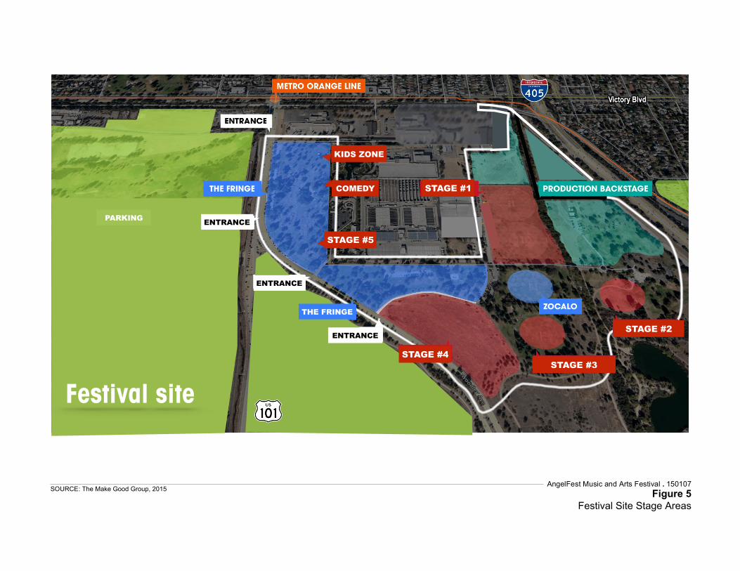
STAGE #1
STAGE #2
COMEDY
ENTRANCE
STAGE #5
ENTRANCE ENTRANCE
STAGE #3
Festival site
KIDS ZONE
ENTRANCE
PARKING ENTRANCE
ENTRANCE
THE FRINGE
STAGE #4
AngelFest Music and Arts Festival . 150107Figure 5
Festival Site Stage Areas
SOURCE: The Make Good Group, 2015
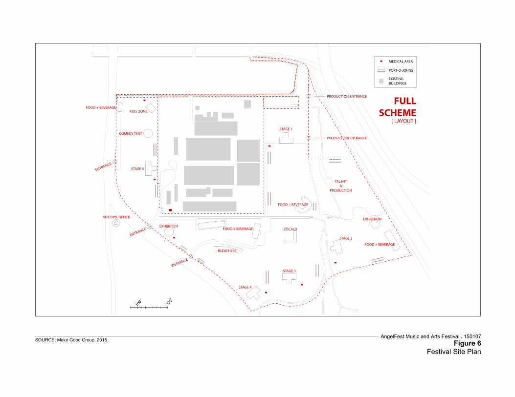
MEDICAL AREA
PORT-O-JOHNS
EXISTINGBUILDINGS
PRODUCTION ENTRANCE
PRODUCTION ENTRANCE
TALENT&
PRODUCTION
FOOD + BEVERAGE
STAGE 1
PRODUCTION PARKING
ZOCALO
EXHIBITION
STAGE 3
STAGE 2
FOOD + BEVERAGE
STAGE 4
BLEACHERS
FOOD + BEVERAGEEXHIBITION
SITE OPS. OFFICE
STAGE 5
COMEDY TENT
KIDS’ ZONEFOOD + BEVERAGE
FULLSCHEME
[ LAYOUT ]
AngelFest Music and Arts Festival . 150107Figure 6
Festival Site Plan
SOURCE: Make Good Group, 2015
Chapter 2: Proposed Action
AngelFest 2-18 150107
Draft Environmental Assessment April 2016
Stage #3 “The Canyons Stage” – This stage would be located at the southern portion of Woodley Park II, directed north towards the TWRP and Zocalo gathering area. The stage would be no more than 30 feet high above the ground surface, and would be constructed in a similar manner as Stage #1. Music would end at Stage #3 before 10:00 p.m. each day, and earlier on Sunday. Stage #3 would provide capacity for 15,000 people during the headline act. Similar amplification as Stage #2 would be used. Stage #4 “The Beach” – This stage would be located in the southwestern corner of the Proposed Project Site, directed north to the TWRP audience gathering in Woodley Park. The stage would be no more than 47 feet high above the ground, and would be constructed in a similar manner as Stage #1. The Beach stage would include temporary placement of up to 132,000 cubic feet of sand atop a layer of visqueen plastic sheeting and include features such as volleyball courts. Music at this stage would continue until 11:00 p.m. Friday and Saturday night of the Festival but on Sunday night it would conclude at 9:45 p.m. Stage #4 would provide capacity for 30,000 people during the headline act. Similar amplification as Stage #1 would be used. Stage #5 – This stage would be located south of the comedy tent in the western portion of Woodley Park (I). The stage would be no more than 30 feet high above the ground surface, and would be constructed in a similar manner as Stage #1. The stage would be directed west towards Woodley Lakes Municipal Golf Course and the Festival entrances. Music would end at Stage #5 before 9:00 p.m. each day. Stage #5 would provide capacity for 5,000 people during the headline act. Similar amplification as Stages #2 and #3 would be used. Comedy Tent – the Comedy Tent would be located just north of Stage #5 in the northwestern portion of Woodley Park (I), and would feature stand-up comedy and local acts and jazz music. The comedy tent would have lower levels of amplified sound. The Comedy Tent would provide capacity for 750 people during the headline act. Kids’ Zone – The Kids’ Zone would be located north of the comedy tent in the northwestern portion of Woodley Park I. The Kids’ Zone stage would feature children’s music and activities including carnival rides and games. The Kids’ Zone music would be moderately amplified. The Kids’ Zone stage would provide capacity for 750 people during the headline act. 2.3.1.4 Sound Systems The sound systems to be used at the stages are described in more detail below, and would be the same for each of the stages, except where noted for the larger stages (Stages #1 and #4). AngelFest would use Fly Larger Systems or flying loudspeaker systems rather than ground or stage stacking the loudspeaker for “The Main Stage” (Stage #1) and “The Beach Stage” (Stage #4). AngelFest would use Cardioid Subwoofer Arrays a method that uses a large number of subwoofers and Digital Signal Processing to create a large directional low frequency loudspeaker array. The array of loudspeakers act together to project the low frequency energy in one main direction, toward the audience, and not in
Chapter 2: Proposed Action
AngelFest 2-19 150107
Draft Environmental Assessment April 2016
off-axis directions (i.e., not to the sides or rear). This often results in an overall lower sound level both on stage and throughout the audience. For the entire Festival planning period and during the operation, production teams would be instructed to use the following steps to reduce off-site noise levels on adjacent neighborhoods and in environmentally sensitive areas: 1. CONTROL DISPERSION: Sound systems with the latest technology would be used
that are able to control the dispersion of sound. Several loudspeaker systems now offer the ability to control both where sound is projected and also where it is not. For the louder stages (The Main Stage (#1), The Beach (#4)), adaptive systems would be used (such as Anya from EAW, or MLA from Martin Audio or other with equivalent capabilities for directing sound using digital signal processing capabilities).
2. OPTIMIZE PERFORMANCE: The performance of the sound systems would be optimized, so that they provide tonally balanced and impactful sound without generating excessive sound energy.
3. DIGITAL SIGNAL PROCESSING (DSP): Use of DSP would control the dispersion of sound. This is a new and very effective tool that has only in the past few years become cost effective and widely used. This technology has been proven effective at several outdoor festivals in reducing the noise levels on adjacent neighborhoods.
4. FLY LARGER SYSTEMS: For larger stages (The Main Stage (#1), The Beach (#4)), flying loudspeakers systems rather than ground or stage stacking the loudspeakers would be employed to physically or electronically aim the loudspeaker systems downward. This allows the sound to be pointed or directed at the audience and not at distance off-site areas.
5. USE DISTRIBUTED DELAY LOUDSPEAKER SYSTEMS: Where required, use of smaller ‘delay loudspeakers’ located within the audience to allow the main loudspeaker systems on the stage to be run at lower levels, throwing sound a more limited distance. The combination of the main loudspeaker systems and the lower level distributed ‘delay’ loudspeakers would allow the audience to hear sound at ‘concert level’ but would reduce off-site noise.
6. USE LOW FREQUENCY ARRAYS: The most common community complaint with regard to intrusive sound is the low frequency ‘thumping bass’. It is the repetitive nature of thumping bass that causes it to be disturbing. To specifically address the low frequency part of the sound, “Cardioid Subwoofer Arrays” would be employed. This is a method that uses a large number of subwoofers and DSP to create a large directional low frequency loudspeaker array. This means that the array of loudspeakers act together to project the low frequency energy in one main direction, toward the audience, and not in an off-axis directions (i.e., not to the sides or rear). This lack of off-axis energy helps musicians hear themselves more easily on stage and not raise the stage volume as high as when traditional subwoofers are used. This often results in an overall lower sound level both on stage and throughout the audience (and in most cases, better quality sound was well).
7. MONITOR SOUND LEVELS ON AND OFF-SITE: Throughout the Festival, noise monitors would be employed to monitor sound levels in real time both at the Front of House and at strategic locations within the communities and the Wildlife Area adjacent to the site during the Festival. This real-time noise monitoring would create

Chapter 2: Proposed Action
AngelFest 2-20 150107
Draft Environmental Assessment April 2016
logs and records to document actual sound levels, and to be consulted in the event of complaints. The monitoring would also be used to inform the production team if noise reaches levels that exceed community standards, so that adjustments in volume could be made.
8. TEST AND VERIFY DURING SETUP. During system setup sound levels would be monitored to set limits on sound system performance levels as measured at Front of House to inform the production team if they are reaching levels that exceed community standards so that volume adjustments could be made.
2.3.1.5 Concession Areas In addition to music stages, AngelFest would feature local food and beverages in concession areas throughout the Proposed Project Site. Approximately 100 10-feet by 10-feet tents, 40 12-feet by 20-feet tents, and ten 20-feet by 20-feet tents would be located throughout the Proposed Project Site. Each tent would be less than 15-feet tall. A merchandise stand would be located just south of the main Festival entrance adjacent to Woodley Avenue. The Festival would include water stands to so that Festival attendees may fill-up their water containers. Plastic water bottles would not be allowed at the event or sold, but metal water bottles would available for purchase. 2.3.1.6 Support Facilities The Festival intends to rely on the widespread use of generators powered by solar and bio-fuels. No electrical energy from the local grid is anticipated. The Festival would employ the following equipment at various times, including setup, the Festival operation, and breakdown activities:
Two (2) twin 300kW generator Seven (7) 125kW generators Two (2) 225kW generators Six (6) 60kW generators Five (5) 40kW generators Sixteen (16) forklifts Eight (8) boom lifts Three (3) platform lifts One (1) 90 ton crane One (1) 40 ton crane One-hundred (100) lighting towers Fifty (50) genie lifts Two-hundred fifty (250) golf carts
Chapter 2: Proposed Action
AngelFest 2-21 150107
Draft Environmental Assessment April 2016
2.3.1.7 Water Use Woodley Park utilizes recycled (gray) water reclaimed from the adjacent TWRP for irrigation and maintenance purposes. The Festival plans to utilize that same water source where possible in accordance with County of Los Angeles and State of California public health regulations for dust control purposes and general irrigation to maintain turf conditions. Gray water would not be used for drinking and/or cooking. The primary potable water would come from the Department of Water and Power. An estimated two gallons per day of potable water per person is anticipated, including water bottle fills, cooking, cleaning, and other concessions. This equates to approximately 390,000 gallons of potable water overall. An estimated 1.7 gallons of recycled (gray) water would be generated per person per day for the three (3)-day Festival. This equates to approximately 331,500 gallons of wastewater. 2.3.1.8 Restroom Facilities Approximately 750 portable toilets, 250 hand-washing stations, and 40 ADA compliant restrooms would be provided throughout the Festival site, providing a ratio of approximately one (1) restroom to 100 people. They would be located in areas that have the necessary accessibility in order to maintain cleanliness, and, to the extent feasible, would be located in areas that have the lowest risk of flooding within the Basin (i.e., highest elevation). See Figure 6 for anticipated locations. No permanent restroom structures that are a part of the existing recreational amenities would be available for Festival attendees. 2.3.1.9 Event Lighting Lighting would be temporarily located throughout the Festival area for entertainment purposes, art displays, special effects, public safety, event cleanup, and after-hours preparation for the next event day. The lighting towers would be powered by solar and bio-fuel generators and would be supported by a large base with support legs. No stakes into the ground would be necessary. All lighting would be directed to the interior of the Proposed Project Site and away from the Wildlife Area. Lighting would be used after dark for security of assets, including the equipment storage area. Six 20 kilowatt (kW) light towers would be temporarily installed and used at night from eight days prior to the Festival until Monday morning after the Festival. Major production equipment would be removed out of the Proposed Project Site on the last show night after the last act. Therefore, on Sunday night work and associated lighting would run from 9:45 p.m. through the night. The equipment storage area would be located east of Haskell Creek and adjacent to the archery range and Dam embankment. Each of the stages would include lighting designed to light the artists. The theatrical lighting instruments would be focused downward onto the stage performance area. Screens would be placed in the back of the stages to project a larger view of the artist and artwork. Light towers would be located throughout the site and in the parking areas for
Chapter 2: Proposed Action
AngelFest 2-22 150107
Draft Environmental Assessment April 2016
exit and security lighting at the conclusion of each Festival day. The towers would be powered by solar and/or bio-fuel-powered generators. Theatrical parabolic aluminized reflector (PAR) lamps and light-emitting diode (LED) lighting fixtures would be placed at the base of the stage and/or hung on some of the Proposed Project Site’s trees to provide pathway lighting. A brief fireworks show could occur to signal the end of the Festival on Saturday. The duration would be 10-15 minutes in length, from either the Main Stage (#1) or Beach Stage (#4) areas. 2.3.1.10 Event Signage Event notification, directional, and detour signage would be located on primary access streets surrounding the Proposed Project Site. These would be placed in coordination with RAP, Los Angeles Department of Transportation (LADOT), California Department of Transportation (Caltrans), and Metro. 2.3.1.11 Waste Management A primary goal of AngelFest is to be the greenest and most water-wise festival worldwide. Recycling and being water-wise will be major and inescapable operating principles and messaging points at the Festival. The Proponent’s Preferred Alternative would incorporate a waste management plan to reduce waste generation by recycling and composting, banning plastic bottles and bags, and providing paperless tickets. The purchasing guidelines of the Festival would be focused on sourcing materials locally and those made from the highest percentage of post-consumer materials available. Current estimates indicate that AngelFest could generate approximately .0018 tons (3.6 pounds) per person of recyclable waste and 0.0016 tons (3.15 pounds) per person of municipal solid waste that is diverted to landfills. These waste management numbers could be greatly reduced through a robust recycling and composting program (nearby composting operations are being considered). Use of bio-based, compostable serving containers, cups, utensils, etc. for the festival’s food and beverage needs and elimination of any plastic bottles would reduce overall consumption of resources and producing of waste. During the three (3) Festival days, regular waste management and cleanup would continuously occur within the Festival area and all parking areas. At the conclusion of each day, waste would be removed from the area and transferred to the appropriate waste collection areas. Following the Festival and during the breakdown period, a comprehensive waste collection effort would be conducted throughout the Proposed Project Site, including all of Woodley and Haskell Creeks, where trash would be removed, but no vegetation cleared.
Chapter 2: Proposed Action
AngelFest 2-23 150107
Draft Environmental Assessment April 2016
2.3.1.12 Fencing A temporary six-foot high chain-link fence with driven posts would be installed around the Proposed Project Site. This is necessary in order to ensure site safety and control access to the Festival. Chain-link fencing would be placed at Festival entrance points along Woodley Avenue. The fence would extend 100 yards on each side of the entrances to create a moat area to prevent items from being tossed over. There would be both fence and bike rack barricades used to maintain the pedestrian walk-ways and entrances to the Proposed Project Site. Mojo Barriers, which are aluminum stage barricades, would be placed in front of each stage. Each stage would include a “VIP” area with Mojo Barriers either left or right the stage. Additionally, there would be a fence line erected around each backstage area to secure the artist and production areas. The backstage fencing would connect to the exterior Festival fence-line and would be screened with green or black windscreen for backstage privacy and security. A waist-high, white picket fence, not driven into the ground, would be placed along the west side of the cricket fields adjacent to the TRWP and near the permanent restrooms between cricket fields three and four. Depending on the location of the fence, it will be covered with cloth, vinyl, and canvas suitable for art and painting. There would be 6 to 12-foot fence line with green polypropylene mesh placed to protect all off-limits park areas including sensitive wildlife/habitat areas (which would be double-fenced for additional protection) and other areas from which pedestrian and/or auto traffic would be restricted. High visibility snow-drift fencing would be placed along the western perimeter of the Wildlife Area along Woodley Avenue between the Festival’s southern boundary and Burbank Boulevard to discourage festival attendees from entering the Wildlife Area during the Festival. Fencing along Haskell Creek and Woodley Creek, which are interior to the Proposed Project Site, would run along the length of the water features, and there would be no access to the Creeks by event staff or Festival attendees during the Festival. In order to prevent access to Haskell Creek and Woodley Creek, the fencing would be fabric covered double-fence as shown in Figure 7.
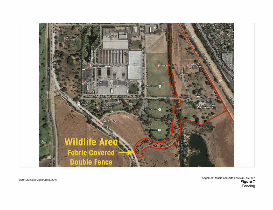
Wildlife Area Fabric Covered Double Fence
AngelFest Music and Arts Festival . 150107Figure 7Fencing
SOURCE: Make Good Group, 2016
Chapter 2: Proposed Action
AngelFest 2-25 150107
Draft Environmental Assessment April 2016
2.3.1.13 Security The Festival would have a director of security who would coordinate with all security personnel required on the Proposed Project Site including the Los Angeles Police Department (LAPD) and Los Angeles Fire Department (LAFD) as well as private security employed by the Festival organizers. Consistent with the Sepulveda Dam Basin Master Plan, there is anticipated to be at least one security guard for every 500 people. A full deployment schedule by each security post would be completed by the director of security and the director would hold daily security briefings during the Festival to update the deployments. The director of security would coordinate with the California Highway Patrol (CHP) on freeway management, freeway signage, and any CHP personnel needed on site. The director of security would coordinate with the LAPD and LA DOT with regards to local roads, road signage and LAPD presence onsite and streets adjacent to the Festival. Private security companies would be used to staff the security posts in the parking lots, walkways, entrances, fence lines, stages, backstage areas, and within the venue. The security presence would be 24-hours a day and seven (7)-days a week from the day that the equipment arrives onsite until the complete removal of all equipment and personnel from the site six (6)-days after the Festival. The Festival would provide a security operations center located centrally within the Proposed Project Site. 2.3.1.14 Emergency Response An emergency response plan for the Festival would be prepared in coordination with LAPD, LAFD, RAP, and the Corps. The plan would cover all types of potential emergency scenarios such as flooding, fire, hazardous material encounters, employee safety, and general public safety. It would be developed during the detailed planning phase of the Festival as directed by the emergency responders. The emergency response plan would include but not be limited to:
Evacuation details and routes for various emergency scenarios; Rain forecast event cancellation details; How emergency announcements would be broadcasted; How the shuttle system could be utilized as part of the evacuation process; Setup and breakdown procedures in the event of a significant emergency; and Human health emergency response.
The Festival would have a safety director to coordinate with all medical and safety personnel onsite, as well as the director of security. The Festival would contract with local emergency services/ambulance services to provide ambulances on the Proposed Project Site during the Festival. The Festival would have on staff physicians, paramedics, and emergency medical teams. EMTs would be stationed at every medical tent, paramedics would be both stationed in the main medical tent and be part of the roaming response teams, and the physicians would be stationed in the main medical tent. The
Chapter 2: Proposed Action
AngelFest 2-26 150107
Draft Environmental Assessment April 2016
Festival would provide a main medical tent in addition to multiple smaller medical tents. The proposed medical areas can be seen on Figure 6. The director of safety would coordinate with the local hospitals for all transports. The director of safety would also coordinate with the director of security and director of site operations to establish the most efficient routes for medical carts onsite and for the best egress for ambulances. 2.3.1.15 Access Traffic and parking would be managed through traffic control, the LAPD, and security oversight, consistent with special event and current best practices. Parking passes would be sold in advance during the ticketing sales process and would consist of color-coded hang tags matching color coded designated parking areas. The passes would have directions and traffic patterns printed on the back to assist patrons and the event staff getting patrons to the appropriate lots. By requiring parking or transit decisions during the ticketing process, it would reduce or eliminate the day-of need to make day-of parking arrangements. This also avoids the potential for overflow parking in local neighborhoods. Access into local neighborhoods would only be accessible to residents and their guests. This access into neighborhoods would be controlled and monitored by Festival security and police presence. Signage and traffic personnel would be used to direct traffic away from the site into major city streets that have direct access to main arteries and freeways. Vehicle ingress and egress routes would include Sherman Way, Balboa Boulevard, Vanowen Street, Woodley Avenue north of Victory Boulevard, and Burbank Boulevard (see Figure 4). To facilitate pedestrian safety, Woodley Avenue would be closed to all traffic, with the exception of emergency services, production vehicles, shuttle buses and law enforcement, between the entrance of Woodley Lakes Municipal Golf Course and Burbank Boulevard beginning Thursday prior to the Festival at 7:00 p.m. and reopening Monday at 10:00 a.m. Woodley Avenue would remain open during other days of the setup and breakdown activities. Haskell Avenue would be closed between Victory Boulevard and the parking lot at Erwin Street / Sepulveda Boulevard from Thursday at 12:00 midnight prior to the Festival through Monday at 10:00 a.m. Partial road closures would occur on Burbank Boulevard (westbound only from I-405 to Woodley Avenue) and the southbound exit from I-405 to Burbank Boulevard, from 8:00 p.m. to 2:00 a.m. on the three (3) days of the Festival. Access into the neighborhood north of the Basin would be restricted to residents and their guests. While the above-cited roadways would be temporarily closed to traffic, and access for adjacent uses would be restricted, there would be suitable alternative routes available. For example, Balboa Boulevard and Sepulveda Boulevard would accommodate north-south traffic that would otherwise use Woodley Avenue and Haskell Avenue, Victory Boulevard would accommodate east-west traffic that would otherwise use Burbank Boulevard, and traffic that wishes to exit I-405 at Burbank Boulevard would be directed to exit onto Victory Boulevard. Access to areas of the Basin not used to support
Chapter 2: Proposed Action
AngelFest 2-27 150107
Draft Environmental Assessment April 2016
the festival (e.g., Lake Balboa/Anthony C. Beilenson Park) would be available from Balboa Boulevard. During the Festival, Woodley Lakes Municipal Golf Course, Woodley Park (I, II, and III), including park picnic tables, restrooms, a trail segment near the northern part of the Wildlife Area, the Japanese Garden, cricket fields, archery range, Balboa Sports Center, Sepulveda Basin Sports Complex, and model airplane field would be closed to the public. The Sepulveda Basin Wildlife Area, Lake Balboa, and Universal Access Playground would remain open during the duration of the Festival. 2.3.1.16 Pedestrian Circulation A Pedestrian Circulation Plan would be developed for agency review (e.g., RAP, Corps, LA Department of Transportation) to describe pedestrian crossings and safety measures at main roadways. The plan would expedite event ingress while minimizing impacts to background traffic. To facilitate pedestrian safety, Woodley Avenue would be closed to all non-event traffic (with the exception of emergency services, shuttle buses, and law enforcement) between the entrance to Woodley Lakes Municipal Golf Course and a point 900 feet north of Burbank Boulevard, beginning Thursday prior to the Festival at 7:00 p.m. and reopening Monday at 10:00 a.m. . Pedestrians leaving the site and going to the following parking/pick-up/drop-off areas would use the described pedestrian routes:
The Van Nuys lot and private charter/shuttle bus areas would cross Woodley Avenue north of the intersection into the model airplane field (at the airstrip landing) and proceed north/south following signage to designated areas.
Woodley Lakes Municipal Golf Course lot, Uber/rideshare program area, Balboa Sports Complex lot and Sepulveda Sports Complex lot would cross Woodley Avenue south of the golf course entrance and proceed north and west following signage and marked crossings to designated areas.
Parent/Taxi Area would be located at the Orange Line Parking lot located at 15430 Erwin Street. Pedestrians would exit the venue following signage and go north on Woodley Avenue, make a right on the Orange Line bike path on the south side of Victory Boulevard to Haskell Avenue, which would remain closed to all except pedestrians and bicyclists, and continue approximately one mile to Orange Line parking lot. As needed, security would be posted along this route.
2.3.1.17 Parking Based on typical industry standards for similar events, about 13,000 attendees, or 20 percent of the expected 65,000 attendees, would use mass transit. About 3,250, or five percent of the expected attendees, would use the pickup/drop-off program. About 3,250, or five percent of the expected attendees, would use private charter buses, and about 1,950 attendees, or three percent of the expected attendees, would use taxi and Uber/Lyft
Chapter 2: Proposed Action
AngelFest 2-28 150107
Draft Environmental Assessment April 2016
taxi services. The remaining estimated 43,550 attendees would arrive in personal vehicles. Historical evidence shows that the average ridership for music concerts is about 2.4 patrons per vehicle. At 43,550 patrons needing parking and 2.4 persons per vehicle, the Festival would require parking accommodations for up to 18,145 vehicles. Based on the onsite parking spaces needed, a minimum of 254 ADA compliant spaces would be needed with 43 of them being van accessible. As shown in Table 1, parking areas to accommodate this demand would be located on- and off-site, totaling 24,157 spaces. The majority of that parking (16,645spaces) would be within the Basin). In addition to the 24,147 confirmed spaces presented in Table 1, several additional off-site satellite parking locations can be available if needed (totaling 5,305 spaces and described in detail in the Traffic Management Plan; see Appendix C to this EA). The percentage of parking capacity at offsite parking locations would be close to 100 percent except on Friday until approximately 7:00 p.m. to accommodate the usual number of evening commuters. Coordination with Metro and LA World Airports would ensure adequate parking is provided for parking users. All parking passes would be sold in advance of the festival so as to avoid parking delays onsite associated with payment and searching for appropriate locations. In the event patrons arrive without parking passes, or patrons wish to purchase a one-day pass, they would be directed to the Fly Away lot or Pierce College lots. Parking passes would be color-coded, according to lot, and would have directions printed on the back to assist patrons and event staff in finding appropriate locations.
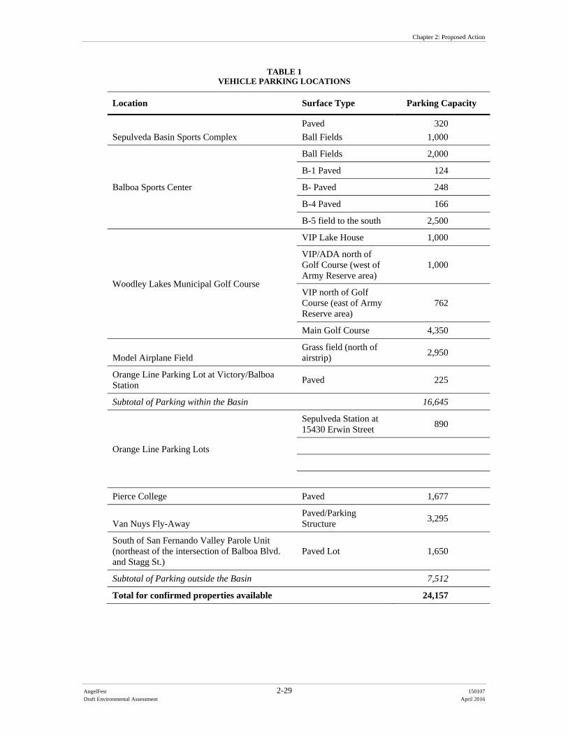
Chapter 2: Proposed Action
AngelFest 2-29 150107
Draft Environmental Assessment April 2016
TABLE 1 VEHICLE PARKING LOCATIONS
Location Surface Type Parking Capacity
Sepulveda Basin Sports Complex
Paved
Ball Fields
320
1,000
Balboa Sports Center
Ball Fields 2,000
B-1 Paved 124
B- Paved 248
B-4 Paved 166
B-5 field to the south 2,500
Woodley Lakes Municipal Golf Course
VIP Lake House 1,000
VIP/ADA north of Golf Course (west of Army Reserve area)
1,000
VIP north of Golf Course (east of Army Reserve area)
762
Main Golf Course 4,350
Model Airplane Field Grass field (north of airstrip)
2,950
Orange Line Parking Lot at Victory/Balboa Station
Paved 225
Subtotal of Parking within the Basin 16,645
Orange Line Parking Lots
Sepulveda Station at 15430 Erwin Street
890
Pierce College Paved 1,677
Van Nuys Fly-Away Paved/Parking Structure
3,295
South of San Fernando Valley Parole Unit (northeast of the intersection of Balboa Blvd. and Stagg St.)
Paved Lot 1,650
Subtotal of Parking outside the Basin 7,512
Total for confirmed properties available 24,157
Chapter 2: Proposed Action
AngelFest 2-30 150107
Draft Environmental Assessment April 2016
Shuttles would be provided to accommodate offsite parking areas. A share of the shuttles would be compressed natural gas (CNG)-powered (as opposed to diesel or gas). Shuttles would load and unload attendees at the Proposed Project Site on Woodley Avenue south of the Y-intersection (see Figure 4). Offsite shuttle pickup and drop-off areas would include the following locations:
Amtrak and Metrolink at Van Nuys and Saticoy Cal State University, Northridge Pierce College Orange Line Parking Van Nuys FlyAway Lot south of San Fernando Valley Parole Unit Veterans Center (Westwood) Universal Studios Valley College Calabasas (MPTF Campus) Santa Clarita Burbank Pasadena Downtown Los Angeles East Los Angeles Community College South Bay The Forum (Inglewood) Balboa Boulevard and Stagg Street Greater Los Angeles VA
2.3.1.18 Transit Option Festival attendees would also be encouraged to use transit options such as those provided by Metrolink, Amtrak, Metro Rail, ridesharing (such as Uber and/or Lyft), and taxis. The Metro Orange Line stops at Woodley Park, Balboa and Victory Boulevards, and Sepulveda and Haskell. Metro Orange Local has six (6) stops on Victory Boulevard all within walking distance of the Proposed Project Site. Shuttle services would be available at all of the Metro Orange Line stops. Shuttle services would also include five (5) of the Metro Rapid (Red) Bus stops along Victory Boulevard between I-405 and Balboa Boulevard. An Amtrak Station is located at Van Nuys Boulevard and Saticoy (3.5 miles bus ride to the Proposal Site). Metrolink stations are located at Van Nuys Boulevard and Saticoy and the Northridge Metrolink Station is located at Wilbur Avenue and Parthenia Street, 0.8 miles southwest of California State University, Northridge. 2.3.2 Festival Production Schedule Setup of the festival would begin 16 days prior to the Festival and would occur from 7:00 a.m. to 8:00 p.m. Approximately 50 to 60 trucks over a 16-day pre-production period
Chapter 2: Proposed Action
AngelFest 2-31 150107
Draft Environmental Assessment April 2016
would deliver Festival materials to the Proposed Project Site, with the majority of the truck trips occurring between the hours of 7:00 a.m. and 6:00 p.m. Different truck types would be used including flatbeds, closed-back trucks, semi-trailers, trailer-hitched cabs, and dump trucks. The trucks would vary in length from 18 feet to 40 feet. Setup activities would include fencing, positioning trailers, portable restrooms, power hookups, stage production equipment, scaffolding, scenery, lighting and sound, and stage erection, set-up of food and beverage operations. Production trailers, portable restrooms, and installation of perimeter and interior fence lines would be positioned and powered 14 days prior to the festival. The entire Proposed Project Site excluding parking sites would become exclusive to the Festival 12 days prior to the Festival and would not be accessible to visitors during that time. Load-in of stage production equipment (stages and stage barricades, sound, lights, and video) and Festival production equipment (e.g., scaffolding, scenery, lighting, and sound) would commence eight (8) days prior to the Festival. Load-in and set-up of food and beverage concessions would begin four (4) days prior to the Festival. Load-out of the production gear and cleanup at Woodley Park would commence on closing night (Sunday). On Monday after the Festival, breakdown would begin for eight (8) days. The site would be restored to its pre-Festival condition. Remediation of the site would include turf restoration, replacement of damaged shrubs and trees, fence and parking lot barrier replacements, cricket field restoration, and other areas as required. Areas used for parking only would reopen after the three-day event, and Woodley Park and other areas would reopen to the public seven (7) days post-Festival (Sunday). 2.3.3 Pre-Festival Site Preparation Activities During the first stages of Festival setup, site preparation activities like mobilization of equipment would occur at the corn maze east of Woodley Avenue, the area north of the cricket fields, and the northeast corner of the Basin, north of the archery range. Consistent with the City of Los Angeles Noise Ordinance, the Festival’s setup and breakdown activities would occur from 7:00 a.m. to 8:00 p.m., Monday through Friday, and from 8:00 a.m. to 6:00 p.m. on Saturdays, unless approval from the Executive Director of the Board of Police Commissioners is granted (Los Angeles Municipal Code Section 41.40). Setup activities will not commence until after the end of the nesting season (roughly September 15), and all Festival equipment must be removed from the Proposed Project Site prior to the beginning of the rainy season (late October). Virtually all of the stage components and structures used are prefabricated and would be assembled on the Proposed Project Site. The structures would not require subsurface installation, except for the chain link fencing in the area behind TWRP. The majority of the equipment that would generally be used for the setup and breakdown activities would include forklifts, boom lifts, platform lifts, cranes, crawler loaders, and skid-steer loaders. Some minor grading would occur north of the cricket fields and north of the archery range.
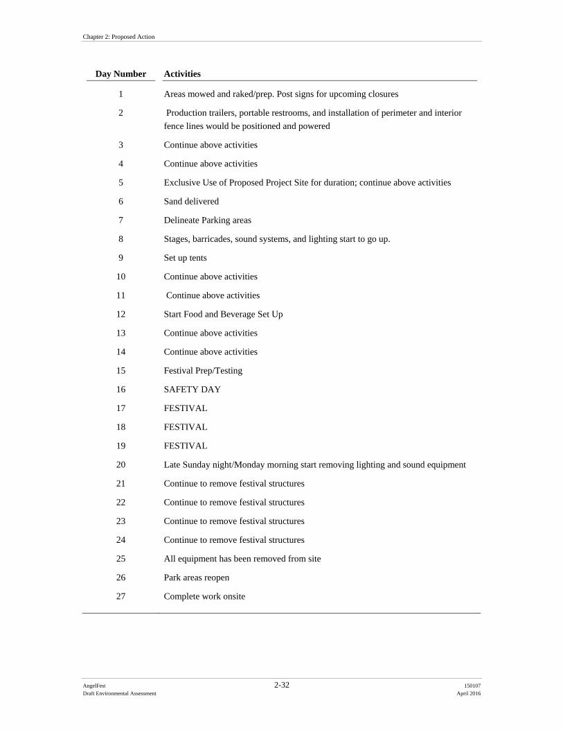
Chapter 2: Proposed Action
AngelFest 2-32 150107
Draft Environmental Assessment April 2016
Day Number Activities
1 Areas mowed and raked/prep. Post signs for upcoming closures
2 Production trailers, portable restrooms, and installation of perimeter and interior
fence lines would be positioned and powered
3 Continue above activities
4 Continue above activities
5 Exclusive Use of Proposed Project Site for duration; continue above activities
6 Sand delivered
7 Delineate Parking areas
8 Stages, barricades, sound systems, and lighting start to go up.
9 Set up tents
10 Continue above activities
11 Continue above activities
12 Start Food and Beverage Set Up
13 Continue above activities
14 Continue above activities
15 Festival Prep/Testing
16 SAFETY DAY
17 FESTIVAL
18 FESTIVAL
19 FESTIVAL
20 Late Sunday night/Monday morning start removing lighting and sound equipment
21 Continue to remove festival structures
22 Continue to remove festival structures
23 Continue to remove festival structures
24 Continue to remove festival structures
25 All equipment has been removed from site
26 Park areas reopen
27 Complete work onsite
Chapter 2: Proposed Action
AngelFest 2-33 150107
Draft Environmental Assessment April 2016
The model airplane field and the corn maze located east of Woodley Avenue would be mechanically mowed and raked (consistent with ongoing vegetation management). However, no subsurface disturbance would occur such that underlying soils and vegetation root systems are disturbed. Subject to the BOS approval, the area north of the cricket fields and east of the water treatment plant, south of the septic tank disposal area, and west of Haskell Creek would be cleared of debris and lightly raked in a similar fashion as described above. The northeast corner of the Basin adjacent to and, north of the archery ranges would be similarly cleared of debris, mowed, and raked. This site preparation would occur up to 10 days in advance of the Festival and would require closures. Closures of these recreation areas would be coordinated through RAP to limit the closure day(s). During the setup period, lighting would be used after dark for security of assets (i.e., the equipment storage area, etc.). This would be done with six 20kW light towers. The area to be lit during setup is east of Haskell Creek and adjacent to the archery range and Dam embankment. Additionally, the major production equipment (sound, lights, video, etc.) would load out of the site on the last show night after the last act departs the stage. Consequently, on Sunday evening, work and associated work lights would run from 9:45 p.m. through the night requiring an additional 90 stagehands. Fuels would be delivered “as needed” to the site. There may be stage pyrotechnics and possibly at the end of Saturday night of the Festival, a fireworks display at the main stage. Pyrotechnics would be delivered on the day for these purposes and would not be stored on-site overnight. Cleaning solutions for food and beverage and restroom maintenance would be subject to City and County of Los Angeles health and sanitation guidelines. Woodley Park I, II and III, the cricket fields, and the archery range would be closed to the public 12 days preceding the Festival and seven (7) days post-Festival. The Japanese Gardens would be closed a total of five (5) days. The Sepulveda Basin Wildlife Area, except for the landscaped northeastern section, Lake Balboa, and Universal Access Playground would remain open during the duration of the Festival including Festival setup and breakdown. The Sepulveda Basin Wildlife area would be accessible via pedestrian access. Parking would be provided in separate parking fenced off for non-Festival visitors located at the dirt lot at the southeast corner of Encino Golf Course, just west of the Los Angeles River and north of Burbank Boulevard. Signs would be placed, as part of the traffic management plan, to direct Wildlife Area visitors to their respective parking areas. The Anthony C. Beilenson Park, including Lake Balboa, would not be used as part of the Festival site or Festival parking. Therefore, access to Anthony C. Beilenson Park, including Lake Balboa, would not be altered and would be accessible via Balboa Boulevard. Parking for Anthony C. Beilenson Park, including Lake Balboa, would not be accessible to Festival attendees. Based on previous events, the cost of the event, and the nature of multi-day events, it is highly unlikely that Festival attendees would use the open recreational facilities’ parking.
Chapter 2: Proposed Action
AngelFest 2-34 150107
Draft Environmental Assessment April 2016
2.3.4 Post-Festival Restoration Immediately following the Festival and during breakdown activities all areas of the Proposed Project Site would be returned to pre-event conditions or better. This includes resod/replanting of turf areas where needed (such as the cricket fields or general Woodley Park areas), replacement of damaged trees and shrubs, cleaning and removal of all waste, and any other cleaning and/or repairs that may be necessary. Areas including but not limited to the cricket fields, golf courses, ball fields, model airplane field, fencing, asphalt parking areas, dirt pathways, and grassy areas would be restored to a condition superior to their pre-production, pre-event status. It would include cleanup of Haskell Creek, but no vegetation removal. The event organizer, Make Good Group, would be required to post a bond for all restoration activities. This would be done consistent with RAP policy and practice. These activities would include, for example, re-sodding of areas worn down by foot or vehicle traffic. RAP Maintenance staff would assess the conditions of the Festival location and parking areas, and restoration would begin within eight (8) days. For sod reestablishment, additional isolated closure may be needed to ensure the regrowth without being damaged. This would result in only localized fenced off areas; not closure of recreational areas. The event organizer and/or RAP would re-inspect the area after sufficient time to ensure reestablishment was successful, or to determine if additional restoration is needed. Additional funding would be requested if more funds than the posted amount are needed. The balance would be returned if fewer funds are used.

AngelFest 3-1 150107
Draft Environmental Assessment April 2016
CHAPTER 3
Baseline Conditions
3.1 Physical Land Resources The Sepulveda Dam Basin is located in the San Fernando Valley, surrounded by the Santa Susana and San Gabriel Mountains to the north, the Santa Monica Mountains to the south, the Verdugo Hills to the east, and the Simi Hills to the west. Elevations within the Proposed Project Site vary from 725 feet at the northernmost portion of the Festival site to a low 692 feet in and around Haskell Creek. 3.1.1 Earthquake Faults The Basin does not lie within a fault zone, however, several active Quaternary faults (faults less than 1.6 million years old) are found in the immediate area:
Northridge Hills Fault is 15.5 miles long, runs in a northwesterly direction, and is located 3.5 miles north of the Basin.
Chatsworth Fault is 12.5 miles long, runs in a northeasterly direction, and is location four miles northwest of the Basin.
Verdugo Fault is 13 miles long, runs in a northwesterly direction, and is located approximately 6.5 miles east of the Basin.
Malibu Coast Fault is located immediately adjacent to the Basin. All four faults are classified as reverse faults, or faults whose displacement is vertical. The most recent surface rupture activity for these faults is estimated to be in the late Quaternary period, most likely less than 130,000 years ago. Although intervals between major ruptures are unknown, the probable magnitude of previous ruptures is estimated between 6.0 to 6.8 magnitude (ML) for the Chatsworth and Verdugo Faults. The Basin is within the state of California’s designated Seismic Zone. These are areas that are based on historic occurrences of liquefaction, local geological, geotechnical, or groundwater conditions and have the potential for permanent ground displacements. 3.2 Water Resources Southern California is known to have little rainfall throughout the year. Normal annual precipitation over the majority of the San Fernando Valley ranges from less than 15 inches to more than 22 inches atop both the Santa Susana and Santa Monica Mountains. Since monthly and annual precipitation rates vary, the most significant contributor to the hydrology of the watershed is storm runoff. Upper watershed runoff into the Basin is a result of high flood peaks of short duration from high intensity rainfall. In particular, the average rainfall for the month of October, the anticipated time frame for the Festival,
Chapter 3: Baseline Conditions
AngelFest 3-2 150107
Draft Environmental Assessment April 2016
within the Basin from 2010-2011 (a particularly wet year) and 2012-2013 (a particularly dry year, was 1.19 inches and 0.42 inches, respectively (LADPW, 2012 and 2014). Because of the highly impervious watershed and efficient storm-drain network, during high intensity rainfall events discharges within the Los Angeles River increase and then recede rapidly. 3.3 Air Quality The Sepulveda Dam Basin lies within the boundaries of the South Coast Air Basin (SCAB), which is managed by the South Coast Air Quality Management District (SCAQMD). The SCAB, which covers an area of approximately 6,745 square miles, is bounded by the Pacific Ocean to the west and the San Gabriel, San Bernardino and San Jacinto Mountains to the north and east, and encompasses Orange County, Riverside County, Los Angeles County except for Antelope Valley, and the non-desert portion of San Bernardino County. 3.3.1 Local Air Quality The California Air Resources Board (CARB) coordinates and oversees state and Federal air pollution control programs in California, oversees activities of local air quality management agencies and maintains air quality monitoring stations throughout the state in conjunction with the US Environmental Protection Agency (EPA) and local air districts. The air quality monitoring station closest to the Basin is the Reseda monitoring station, which is located approximately 2.4 miles from the Proposed Project Site at 18330 Gault Street in the community of Reseda. This station monitors ambient concentrations of ozone, NO2, CO, PM10, and PM2.5. Historical data of ambient concentrations from the Reseda monitoring station for the most recent three years (2012 – 2014) are shown in Table 2. The EPA uses this type of monitoring data to designate areas according to their attainment status for criteria air pollutants. The purpose of these designations is to identify the areas with air quality problems and thereby initiate planning efforts for improvement. The three basic designation categories are nonattainment, attainment, and unclassified. Unclassified is used in an area that cannot be classified on the basis of available information as meeting or not meeting the standards. The current Federal attainment statuses for the SCAB are provided in Table 3.
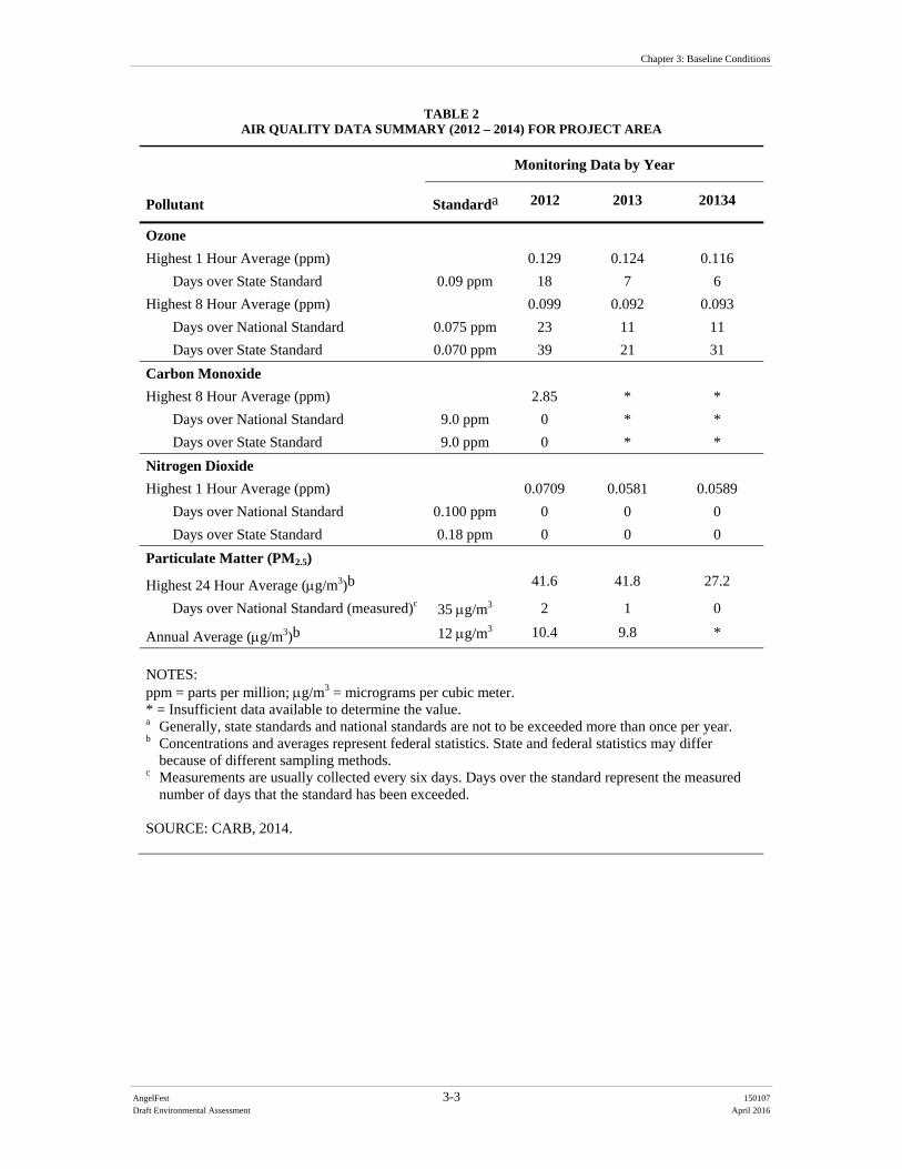
Chapter 3: Baseline Conditions
AngelFest 3-3 150107
Draft Environmental Assessment April 2016
TABLE 2 AIR QUALITY DATA SUMMARY (2012 – 2014) FOR PROJECT AREA
Pollutant
Monitoring Data by Year
Standarda 2012 2013 20134
Ozone
Highest 1 Hour Average (ppm) 0.129 0.124 0.116
Days over State Standard 0.09 ppm 18 7 6
Highest 8 Hour Average (ppm) 0.099 0.092 0.093
Days over National Standard 0.075 ppm 23 11 11
Days over State Standard 0.070 ppm 39 21 31
Carbon Monoxide
Highest 8 Hour Average (ppm) 2.85 * *
Days over National Standard 9.0 ppm 0 * *
Days over State Standard 9.0 ppm 0 * *
Nitrogen Dioxide
Highest 1 Hour Average (ppm) 0.0709 0.0581 0.0589
Days over National Standard 0.100 ppm 0 0 0
Days over State Standard 0.18 ppm 0 0 0
Particulate Matter (PM2.5)
Highest 24 Hour Average (g/m3)b 41.6 41.8 27.2
Days over National Standard (measured)c 35 g/m3 2 1 0
Annual Average (g/m3)b 12 g/m3 10.4 9.8 *
NOTES: ppm = parts per million; g/m3 = micrograms per cubic meter. * = Insufficient data available to determine the value. a Generally, state standards and national standards are not to be exceeded more than once per year. b Concentrations and averages represent federal statistics. State and federal statistics may differ
because of different sampling methods. c Measurements are usually collected every six days. Days over the standard represent the measured
number of days that the standard has been exceeded. SOURCE: CARB, 2014.
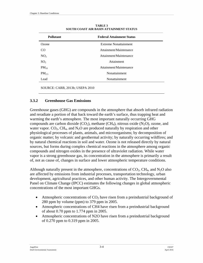
Chapter 3: Baseline Conditions
AngelFest 3-4 150107
Draft Environmental Assessment April 2016
TABLE 3 SOUTH COAST AIR BASIN ATTAINMENT STATUS
Pollutant Federal Attainment Status
Ozone Extreme Nonattainment
CO Attainment/Maintenance
NO2 Attainment/Maintenance
SO2 Attainment
PM10 Attainment/Maintenance
PM2.5 Nonattainment
Lead Nonattainment
SOURCE: CARB, 2013b; USEPA 2010
3.3.2 Greenhouse Gas Emissions Greenhouse gases (GHG) are compounds in the atmosphere that absorb infrared radiation and reradiate a portion of that back toward the earth’s surface, thus trapping heat and warming the earth’s atmosphere. The most important naturally occurring GHG compounds are carbon dioxide (CO2), methane (CH4), nitrous oxide (N2O), ozone, and water vapor. CO2, CH4, and N2O are produced naturally by respiration and other physiological processes of plants, animals, and microorganisms; by decomposition of organic matter; by volcanic and geothermal activity; by naturally occurring wildfires; and by natural chemical reactions in soil and water. Ozone is not released directly by natural sources, but forms during complex chemical reactions in the atmosphere among organic compounds and nitrogen oxides in the presence of ultraviolet radiation. While water vapor is a strong greenhouse gas, its concentration in the atmosphere is primarily a result of, not as cause of, changes in surface and lower atmospheric temperature conditions. Although naturally present in the atmosphere, concentrations of CO2, CH4, and N2O also are affected by emissions from industrial processes, transportation technology, urban development, agricultural practices, and other human activity. The Intergovernmental Panel on Climate Change (IPCC) estimates the following changes in global atmospheric concentrations of the most important GHGs.
Atmospheric concentrations of CO2 have risen from a preindustrial background of 280 ppm by volume (ppm) to 379 ppm in 2005.
Atmospheric concentrations of CH4 have risen from a preindustrial background of about 0.70 ppm to 1.774 ppm in 2005.
Atmospheric concentrations of N2O have risen from a preindustrial background of 0.270 ppm to 0.319 ppm in 2005.
Chapter 3: Baseline Conditions
AngelFest 3-5 150107
Draft Environmental Assessment April 2016
The IPCC has concluded that these changes in atmospheric composition are almost entirely the result of human activity, not the result of changes in natural processes that produce or remove these gases. CO2, CH4 and N2O have atmospheric residence times ranging from about a decade to more than a century. Several other important GHG compounds with long atmospheric residence times are produced almost entirely by various industrial processes; these include sulfur hexafluoride (SF6) and a wide range of fluorinated hydrocarbons (HFCs). Fluorinated compounds typically have atmospheric residence times ranging from a few decades to thousands of years. The overall global warming potential of GHG emissions is typically present in terms of carbon dioxide equivalents (CO2e), using equivalency factors developed by the IPCC. The IPCC has published sets of CO2e factors as part of its periodic climate change assessment reports issued in 1995, 2001, and 2007. The latest IPCC data assign global warming potential multipliers of 1 to CO2, 25 CH4 and 298 to N2O. The global warming potential multiplier for SF6 is 22,800; global warming potential multiplier for HFCs vary widely according to the specific compound. Scientific research to date indicates that observed climate change is most likely a result of increased emission of GHGs associated with human activity. California produced 459 gross MMTCO2e in 2013 (CARB, 2015). Combustion of fossil fuel in the transportation sector was the single largest source of California’s GHG emissions in 2013, accounting for 36.8 percent of total GHG emissions in the state (CARB, 2015). This sector was followed by the industrial sector (20.2 percent) and the electric power sector (including both in-state and out-of-state sources) (19.7 percent) (CARB, 2015). 3.4 Climate Change Climate change is a change in the average climatic conditions of the earth, as characterized by changes in wind patterns, storms, precipitation, and temperature. Climate models applied to California's conditions project that under different scenarios, temperatures in California are expected to increase by 3 to 10.5 degrees F (CCC 2006). As such, temperature increases would lead to adverse environmental impacts in a wide variety of areas, including sea level rise, increased risk of wildfires, public health hazards associated with higher peak temperatures, heat waves, and decreased air quality. The potential adverse effects of climate change would affect Los Angeles County. Climate change is expected to cause sea level rise threatening urban and natural coastal areas; cause variations in natural plant communities affecting wildlife; cause variations in crop quality and yields; exacerbate air quality problems that would adversely affect human health by increasing heat stress and related deaths; and increase the incidence of infectious diseases, asthma, and respiratory health problems. Climate change is also expected to result in more extreme weather events and heavier precipitation events that can lead to flooding as well as more extended drought periods. Almost all climate scenarios include a continuing trend of warming through the end of the 21st century given the substantial amounts of greenhouse gases already released and the difficulties associated with reducing emissions to a level that would stabilize the climate.
Chapter 3: Baseline Conditions
AngelFest 3-6 150107
Draft Environmental Assessment April 2016
Climate change is additionally expected to result in more severe drought events. The southern California region has experienced four consecutive below normal rainfall seasons. Although droughts are often started by lower-than-usual levels of precipitation, there have been many periods of low precipitation in California’s recent and distant past; the current drought may also be affected by rising temperatures which contribute to drought’s severity, by increasing evaporation and decreasing soil moisture (UCLA and LARC 2014). 3.5 Noise Noise can be defined as unwanted sound or combination of sounds that may interfere with conversation, work, rest, recreation, and sleep, or in the extreme may produce physiological or psychological damage. Sound travels from a source in the form of wave, which exerts a pressure on a receptor such as a human ear. The amount of pressure a sound wave exerts is referred to as sound level, commonly measured in decibels (dB). As a reference, a sound level of zero dB corresponds roughly to the threshold of human hearing, and a sound level in the range of 120 to 140 dB can produce human pain. Sound has two main components to a human ear; pitch and loudness. While the pitch of a sound is generally associated with an annoyance, sound loudness can interfere with activities such as conversation, sleep, and learning, and can even have lasting physiological effects, such as hearing loss. Those who are more sensitive to noise such as children and the elderly are at higher risk of being adversely affected by excessive noise levels. Figure 8 lists some of the sources and effects associated with a typical range of noise levels. Noise can be one of the most widespread environmental pollutants affecting communities. “Community noise,” or environmental noise, in any given area varies continuously over a period of time depending on the contributing sound sources within and surrounding the area. This community noise is typically made up of a combination of relatively stable background noise, where individual contributors are not identifiable, and the periodic addition of short duration noise sources such as aircraft flyovers, motor vehicles, sirens, etc. Some land uses can be considered more sensitive to community noise levels than others, and are often referred to as sensitive receptors. These include residences, schools, hotels, hospitals, nursing homes, churches, libraries, and cemeteries. Shopping centers, commercial parks, strip malls, industrial areas, and active recreation areas can be considered less noise-sensitive receptors.
Chapter 3: Baseline Conditions
AngelFest 3-7 150107
Draft Environmental Assessment April 2016
In addition, wildlife may be sensitive receptors to noise and vibrations. Animals rely on meaningful sounds for communication, navigation, avoiding danger and finding food. Noise may be defined for wildlife as “any human sound that alters the behavior of animals or interferes with their functioning” (Bowles, 1995). The level of disturbance may be qualified as damage, which may harm health, reproduction, survivorship, habitat use, distribution, abundance or genetic distribution, or disturbance which causes a detectable change in behavior. Behavioral and physiological responses of wildlife to noise have the potential to cause injury, energy loss, decrease in food intake, habitat avoidance and abandonment, and reproductive losses (National Park Service, 1994). 3.5.1 Existing Noise Environment Roadway vehicle traffic is the primary source of noise in and around the Basin. The Basin is bordered by I-405 on the east and by U.S. 101 on the south; the Basin lies in the northwest corner of the junction of these freeways. The Basin is also bordered by several other main traffic arteries including Sepulveda Boulevard, Ventura Boulevard, White Oak Avenue, Van Nuys, and Victory Boulevards. Woodley Avenue, Burbank Boulevard and Balboa Boulevard pass through the Basin. Operation of the Van Nuys Airport, located at approximately 2.6 miles north of the Basin, also contributes to the existing noise levels in the area. Long-term (24-hour) noise measurements were taken in the vicinity of Receptor Locations R5 and R25 on November 4, 2015 (see Figure 9). These noise measurements were conducted using Metrosonics Model db-3080 sound level meters that were calibrated prior to use and operated according to the manufacturer’s written specifications. The location of the long-term noise measurements are shown in Figure 9, and the hourly noise levels that were recorded at the two locations are provided in Table 4.
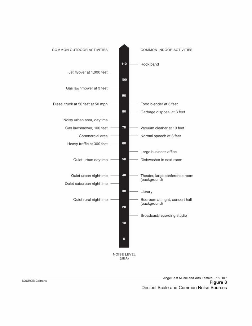
Rock band
Gas lawnmower at 3 feet
Diesel truck at 50 feet at 50 mph Food blender at 3 feet
Garbage disposal at 3 feet
Noisy urban area, daytime
Gas lawnmower, 100 feet Vacuum cleaner at 10 feet
Commercial area Normal speech at 3 feet
Quiet urban daytime Dishwasher in next room
Quiet urban nighttime Theater, large conference room (background)
Quiet suburban nighttime
Library
Quiet rural nighttime Bedroom at night, concert hall (background)
Broadcast/recording studio
COMMON OUTDOOR ACTIVITIES COMMON INDOOR ACTIVITIES
NOISE LEVEL(dBA)
110
100
90
80
70
60
50
40
30
20
10
0
SOURCE: CaltransAngelFest Music and Arts Festival . 150107
Figure 8Decibel Scale and Common Noise Sources
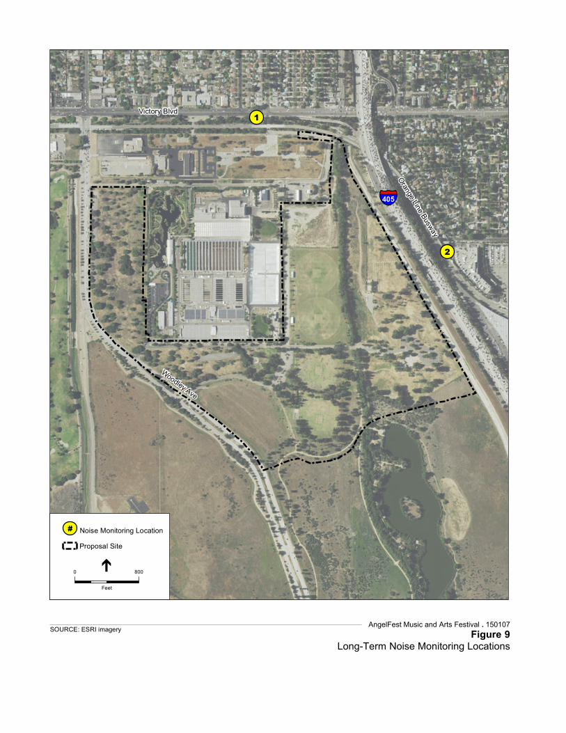
Service Layer Credits: Source: Esri,DigitalGlobe, GeoEye, Earthstar Geographics,CNES/Airbus DS, USDA, USGS, AEX,Getmapping, Aerogrid, IGN, IGP, swisstopo,and the GIS User Community
1
2
§̈¦405
Victory Blvd
Woodley Ave
Orange Line Busway
AngelFest Music and Arts Festival . 150107 Figure 9
Long-Term Noise Monitoring LocationsSOURCE: ESRI imagery
# Noise Monitoring LocationProposal Site
0 800
Feet
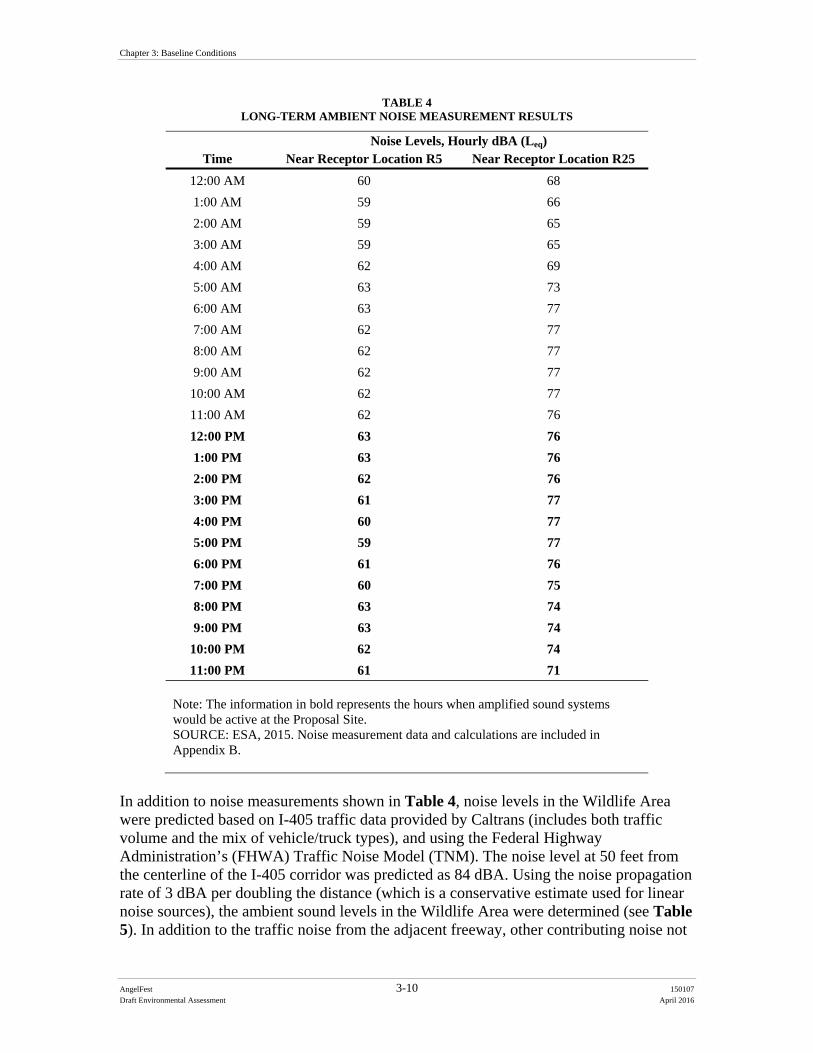
Chapter 3: Baseline Conditions
AngelFest 3-10 150107
Draft Environmental Assessment April 2016
TABLE 4 LONG-TERM AMBIENT NOISE MEASUREMENT RESULTS
Time Noise Levels, Hourly dBA (Leq)
Near Receptor Location R5 Near Receptor Location R25
12:00 AM 60 68
1:00 AM 59 66
2:00 AM 59 65
3:00 AM 59 65
4:00 AM 62 69
5:00 AM 63 73
6:00 AM 63 77
7:00 AM 62 77
8:00 AM 62 77
9:00 AM 62 77
10:00 AM 62 77
11:00 AM 62 76
12:00 PM 63 76
1:00 PM 63 76
2:00 PM 62 76
3:00 PM 61 77
4:00 PM 60 77
5:00 PM 59 77
6:00 PM 61 76
7:00 PM 60 75
8:00 PM 63 74
9:00 PM 63 74
10:00 PM 62 74
11:00 PM 61 71 Note: The information in bold represents the hours when amplified sound systems would be active at the Proposal Site. SOURCE: ESA, 2015. Noise measurement data and calculations are included in Appendix B.
In addition to noise measurements shown in Table 4, noise levels in the Wildlife Area were predicted based on I-405 traffic data provided by Caltrans (includes both traffic volume and the mix of vehicle/truck types), and using the Federal Highway Administration’s (FHWA) Traffic Noise Model (TNM). The noise level at 50 feet from the centerline of the I-405 corridor was predicted as 84 dBA. Using the noise propagation rate of 3 dBA per doubling the distance (which is a conservative estimate used for linear noise sources), the ambient sound levels in the Wildlife Area were determined (see Table 5). In addition to the traffic noise from the adjacent freeway, other contributing noise not
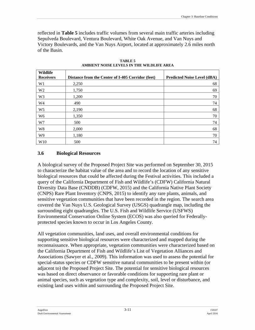
Chapter 3: Baseline Conditions
AngelFest 3-11 150107
Draft Environmental Assessment April 2016
reflected in Table 5 includes traffic volumes from several main traffic arteries including Sepulveda Boulevard, Ventura Boulevard, White Oak Avenue, and Van Nuys and Victory Boulevards, and the Van Nuys Airport, located at approximately 2.6 miles north of the Basin.
TABLE 5 AMBIENT NOISE LEVELS IN THE WILDLIFE AREA
Wildlife Receivers Distance from the Center of I-405 Corridor (feet) Predicted Noise Level (dBA)
W1 2,250 68
W2 1,750 69
W3 1,200 70
W4 490 74
W5 2,190 68
W6 1,350 70
W7 500 74
W8 2,000 68
W9 1,180 70
W10 500 74 3.6 Biological Resources A biological survey of the Proposed Project Site was performed on September 30, 2015 to characterize the habitat value of the area and to record the location of any sensitive biological resources that could be affected during the Festival activities. This included a query of the California Department of Fish and Wildlife’s (CDFW) California Natural Diversity Data Base (CNDDB) (CDFW, 2015) and the California Native Plant Society (CNPS) Rare Plant Inventory (CNPS, 2015) to identify any rare plants, animals, and sensitive vegetation communities that have been recorded in the region. The search area covered the Van Nuys U.S. Geological Survey (USGS) quadrangle map, including the surrounding eight quadrangles. The U.S. Fish and Wildlife Service (USFWS) Environmental Conservation Online System (ECOS) was also queried for Federally-protected species known to occur in Los Angeles County. All vegetation communities, land uses, and overall environmental conditions for supporting sensitive biological resources were characterized and mapped during the reconnaissance. When appropriate, vegetation communities were characterized based on the California Department of Fish and Wildlife’s List of Vegetation Alliances and Associations (Sawyer et al., 2009). This information was used to assess the potential for special-status species or CDFW sensitive natural communities to be present within (or adjacent to) the Proposed Project Site. The potential for sensitive biological resources was based on direct observance or favorable conditions for supporting rare plant or animal species, such as vegetation type and complexity, soil, level or disturbance, and existing land uses within and surrounding the Proposed Project Site.
Chapter 3: Baseline Conditions
AngelFest 3-12 150107
Draft Environmental Assessment April 2016
3.6.1 Vegetation Communities 3.6.1.1 Festival Site The Proposed Project Site is largely within Woodley Park, and the majority of the park facilities consist of a diversity of native and non-native trees, such as (but not limited to) California sycamore (Platanus racemosa), coast live oak (Quercus agrifolia), blue gum (Eucalyptus globulus), and Mexican fan palm (Washingtonia robusta). The grounds within these areas consist mostly of maintained lawn and areas of bare ground. Children’s playgrounds, barbecue pits, picnic tables, and restroom facilities are scattered throughout these areas, as well as a series of public paved roads and parking lots. The Proposed Project Site also includes the use of two multi-purpose activity fields, two cricket fields, and an archery range. Sports fields used for soccer, baseball, and cricket fields consist of manicured turf. The archery range has sparse ground cover and is mostly bare ground with patchy lawn worn down from foot traffic. The Proposed Project Site also includes three areas of Woodley Park that are not maintained for public use, one in the southern portion of the Proposed Project Site adjacent to Woodley Avenue (known as the corn maze), and two in the northeast corner of the Basin on each side of Haskell Creek. The corn maze consists of a gentle slope towards a flat open area that is mowed regularly and dominated by Sahara mustard (Brassica tournefortii) and brome grasses (Bromus ssp.), with a few scattered coyote brush (Baccharis pilularis), and Russian thistle (Salsola tragus). An unmaintained area located to the east of Haskell Creek is dominated by Sahara mustard and brome grasses and bare ground as a result of vehicle and foot traffic. Haskell Creek runs through the eastern portion of the Proposed Project Site. The creek is lined by a mix of riparian forest dominated by mature willow trees (Salix ssp.), with cottonwood (Populus fremontii), California sycamore, and California black walnut (Juglans californica) occurring sporadically. This area is characterized as Southern Mixed Riparian Forest, which is a CDFW designated sensitive natural community. The southern and southeastern portions of the Festival site are within the northern portion of Sepulveda Basin Wildlife Area. The Sepulveda Basin Wildlife Area includes approximately 225 acres of native riparian and upland habitat. As shown in Figure 3, the Proposed Project Site would be situated on approximately 46 acres of a developed park (Woodley III) in the northern portion of the Wildlife Area that has been previously disturbed and does not contain habitat for wildlife other than common resident birds. The developed park area within Woodley III consists of a paved public road, parking lot, and restroom facilities, surrounded by a mixed woodland and lawn with patches of bare ground. Haskell Creek extends through the wildlife area adjacent to where Festival activities would occur. The approximately 11 acres of the Proposed Project Site within the Wildlife Area (outside of Woodley III) is located between Haskell Creek and Woodley Avenue, and includes dirt pedestrian trails, valley oak (Quercus lobata) and
Chapter 3: Baseline Conditions
AngelFest 3-13 150107
Draft Environmental Assessment April 2016
coast live oak trees, and an understory of non-native brome grasses. A few native coyote brush shrubs are also scattered in this area. The Proposed Project Site outside Woodley I, II, and III includes a portion of the surface paved parking lot within the Japanese Garden. The Japanese Garden has ornamental species set amongst pedestrian trails and a man-made water feature. 3.6.1.2 Parking Areas Parking for the Festival at the Woodley Lakes Municipal Golf Course is proposed on two bare dirt lots currently used for parking at the north end of the golf course, as well as existing paved parking areas, and on the fairways of the 18-hole course. The golf course includes open maintained fairways lined with mature native and non-native trees of mixed species similar to those within Woodley Park, as well as man-made ponds. The model airplane field includes approximately 90 acres of disturbed areas dominated with non-native grasses with occasional patches of coyote brush and black mustard. These vegetation types serve as foraging habitat as well as nesting habitat for certain taxa of birds, such as house finch (Haemorhous mexicanus) or lesser goldfinch (Spinus psaltria). Parking is proposed on the northern part of the disturbed grassy area (north of the airstrip). The grassy area is dominated by brome grasses and Sahara mustard and is underneath the airspace of the flying field. It is said that model plane crashes can ignite fires, which periodically burn the vegetation within the airfield. Patches of burnt ground and dead or singed shrubs were observed during the reconnaissance. The Balboa Sports Center and Sepulveda Basin Sports Complex have sports fields used for baseball and soccer and associated parking facilities, both paved and gravel areas. Parking for the Festival is proposed to occur on the existing parking facilities and on the sports fields. 3.6.2 Common Wildlife Bird species observed during the reconnaissance include black phoebe (Sayornis nigricans), house finch, red-tailed hawk (Buteo jamaicensis), and common raven (Corvux corax). An osprey (Pandion haliaetus) was observed during the site reconnaissance; however, the occurrence of this species is seasonal and this is not a year-round resident. In addition, red-tailed hawk, red-shouldered hawk (Buteo lineatus), Cooper’s hawk (Accipiter cooperii), barn owl (Tyto alba), and great-horned owl (Bubo virginianus) are species known to nest and forage within the Basin and Proposed Project Site. California ground squirrel (Otospermophilus beecheyi) were observed during the reconnaissance throughout Woodley Park and a particularly high density of burrows were observed along the edge of the sloped portion of the unmaintained park area (corn maze) at the south end of the Proposed Project Site. Other small mammals such as desert cottontail (Sylvilagus audubonii), and Botta’s pocket gopher (Thomomys bottae) likely occur in the undeveloped areas of the Proposed Project Site. Large mammals such as
Chapter 3: Baseline Conditions
AngelFest 3-14 150107
Draft Environmental Assessment April 2016
coyote (Canis latrans), raccoon (Procyon lotor), and opossum (Didelphis virginiana) likely use all of the Proposed Project Site and the golf courses to move between foraging and shelter sites. Coyotes in particular are known to utilize nearly all of the Proposed Project Site for foraging, while resting or denning in very specific areas, and have been observed directly in many parts of the Proposed Project Site. It is estimated that one to two coyote family groups exist within the Sepulveda Basin and environs. Common bats such as big brown bat (Eptesicus fuscus) could forage on insects within the Proposed Project Site. Amphibians such as Pacific treefrog (Pseudacris regilla) are expected to occur in areas immediately adjacent to Haskell Creek, and reptiles such as western fence lizard (Sceloporus occidentalis) are expected to occur throughout the Proposed Project Site and undeveloped proposed parking areas. Numerous other common wildlife species that are adapted to urban conditions are expected to occur within the Proposed Project Site as well. 3.6.3 Federally Listed Species The Proposed Project Site does not support habitat for any Federally-protected plant species. The following wildlife species receive specific protection that is defined by federal endangered species legislation. Federally-endangered least Bell’s vireo (Vireo belii ssp. pusillus) is known to breed in immediately adjacent to the Proposed Project Site. The least Bell’s vireo (LBVI) was Federally listed as endangered in 1986. Federally designated critical habitat exists for the species, but not at Sepulveda Dam Basin. Nonetheless, the vireo breeding habitat along riparian vegetation of Haskell Creek is still protected under Endangered Species Act (ESA). The least Bell’s vireo is the westernmost subspecies of the Bell’s vireo. The least Bell’s vireo breeding season extends from March through September. The natural history and ecology of the least Bell’s vireo has been intensively studied in both published journals and gray literature for 37 years (1978 – 2015) by a variety of government, academic, and consulting biologists. Vireos are known to breed in specific land parcels with the Sepulveda Basin such as the Los Angeles River. LBVI have been expanding their breeding territories within Sepulveda Basin. Vireo were first encountered along the Los Angeles River in 2010, were then found to inhabit Bull Creek in 2012, and expanded their breeding territories in Haskell Creek in 2014 where large population existed in 2015. Because this riparian habitat is intact, it is predicted that the northern extent of the Haskell Creek riparian habitat may eventually be used by LBVI, if certain conditions are met. Vireo breeding territory is within 150 feet of a proposed stage location where Haskell Creek bisects the Proposed Project Site.
Chapter 3: Baseline Conditions
AngelFest 3-15 150107
Draft Environmental Assessment April 2016
3.6.4 Jurisdictional Resources Haskell Creek flows into the Los Angeles River, a known Traditional Navigable Water that is under the jurisdiction of the Corps. The recycled water from TWRP is used for the Japanese Garden Lake, the Wildlife Area Lake, Lake Balboa, and Bull Creek all of which flow into the Los Angeles River. The remainder of the TWRP treated water is discharged to the Los Angeles River through Haskell Creek. The creek heads at the north-end of the Festival site where a storm water drain outlets into the creek (just south of Victory Boulevard). The creek flows southward through the Proposed Project Site. The creek continues southward through the Sepulveda Basin Wildlife Area and the confluence of Haskell Creek and the Los Angeles River is less than one mile south of the Proposed Project Site. 3.6.5 Wildlife Corridors As noted in the Los Angeles County’s 1996 Los Angeles River Master Plan, migratory and resident birds move along the major flyways between the Los Angeles River, and other sites with surface water such as the Sepulveda Basin. The 225-acre Sepulveda Basin Wildlife Preserve is the only officially designated wildlife area along the River, within the City. The soft-bottom portions of the Los Angeles River here provide valuable resting and feeding zones for migratory birds, yet these areas are seasonally inundated with high flows, which often preclude nesting. Haskell Creek provides opportunities for local wildlife movement for species that may use the river to travel between habitats, including those that occur at Woodley Park and Haskell Creek. For example, Canada geese have returned to the Basin every year for the last 30 years. Predators such as coyotes, birds of prey, and Neotropical migrating birds are present and use the Basin. More specifically, Woodley Park, Haskell Creek and other open space areas in the vicinity of the Proposed Project Site, even though disturbed, may provide stopover habitat for migrating birds, and common terrestrial species such as skunk, long-tailed weasels and coyote that use the Los Angeles River and Haskell Creek for local movement. A wildlife movement or habitat linkage study has not been completed for the project; however, the connection between Haskell Creek and the Los Angeles River provides local and regional terrestrial wildlife an opportunity to move between areas of suitable habitat. In addition, areas of relatively intact vegetation communities found in Haskell Creek and the Wildlife Area provide stopover for migratory birds to forage and rest. The Proposed Project Site is situated partially within and immediately adjacent to the Sepulveda Basin Wildlife Area which is used by various terrestrial mammalian species that are endemic to the region, as well as migratory and resident avian species. 3.6.6 Protected Trees California black walnut and California sycamore trees are protected by the City of Los Angeles Protected Tree Ordinance and occur scattered along the edges of Haskell Creek. Coast live oak and valley oak trees are found within the Sepulveda Basin Wildlife Area and are also protected by the City of Los Angeles Protected Tree Ordinance. California
Chapter 3: Baseline Conditions
AngelFest 3-16 150107
Draft Environmental Assessment April 2016
sycamore, coast live oak, and California black walnut are found in Woodley Park and the surrounding golf courses. 3.7 Cultural Resources Cultural resources are expressions of human culture and history in the physical environment, and may include archaeological sites, buildings, structures, objects, districts, works of art, architecture, and natural features that were important in past human events. They may consist of physical remains, but also may include areas where significant human events occurred, even though evidence of the events no longer remains. Cultural resources also include definite locations (sites or places) of traditional cultural or religious importance to specified social and/or cultural groups. Section 106 of the National Historic Preservation Act (NHPA) requires a Federal agency with jurisdiction over a proposed Federal action (referred to as an “undertaking” under the NHPA) to take into account the effects of the undertaking on historic properties, and to, in certain circumstances, provide the Advisory Council on Historic Preservation (ACHP) an opportunity to comment on the undertaking. The term “historic properties” refers to “any prehistoric or historic district, site, building, structure, or object included in, or eligible for inclusion in, the National Register [of Historic Places]” (36 CFR 800.16(l)(1)). The steps of the Section 106 process are accomplished through consultation with the State Historic Preservation Office (SHPO), Federally-recognized Indian tribes, local governments, and other interested parties. The goal of consultation is to identify potentially affected historic properties, assess effects to such properties, and seek ways to avoid, minimize, or mitigate any adverse effects on such properties. An Area of Potential Effects (APE) is defined as “the geographic area or areas within which an undertaking may directly or indirectly cause changes in the character or use of historic properties” (36 CFR 800.16(d)). The APE for this project is defined as the Proposed Project Site which includes the Festival site and onsite parking areas (including the Balboa Municipal Golf Course and the Balboa Recreation Center, which are considered as parking options in Alternative 2), as well as the offsite parking areas described above and on Figure 4. The APE is generally heavily disturbed by grading and development. 3.7.1 Known Cultural Resources A project-specific cultural resources records search was conducted at the California Historical Resources Information System-South Central Coastal Information Center (CHRIS-SCCIC) in October, 2015. This records search included an examination of previous survey coverage and reports, and known cultural resources within the APE, as well as within a half-mile radius of the Festival site. Other sources that were reviewed included the California Points of Historical Interest, the California Historical Landmarks, the California Register of Historical Resources (California Register), the National Register of Historic Places (National Register), and the California State Historic Resources Inventory.
Chapter 3: Baseline Conditions
AngelFest 3-17 150107
Draft Environmental Assessment April 2016
Results of the CHRIS-SCCIC search indicate that the Proposed Project Site has been a part of ten archaeological studies, which cover approximately 100 percent of the Proposed Project Site. Four resources are located within ½-mile of the Proposed Project Site and include a college gymnasium (P-19-188834), the Sepulveda Dam (P-19-188093), and two Cold War-era military sites (P-19-189772 and P-19-187950). One prehistoric site, CA-LAN-345, was previously recorded in one of the planned parking areas but was noted as destroyed prior to 1977. A Sacred Lands Search for the Proposed Project Site was requested from the Native American Heritage Commission (NAHC) in October 2015. A response was received on November 3, 2015. No Native American cultural resources were identified as a result of the Sacred Lands File search. Project notification/consultation letters were sent to individuals and tribes on the NAHC list and the SHPO in March 2016 and follow-up calls with Native American contacts are in process to identify any concerns. The general Proposed Project Site vicinity is considered sensitive for prehistoric archaeological resources. The Los Angeles River and Encino Spring were important water sources, and prehistoric settlement would have concentrated around them. Prehistoric archaeological site CA-LAN-345 was previously recorded about ½ mile from the Proposed Project Site. In addition, although not identified in the records search, and not within the Proposed Project Site, an additional prehistoric site (CA-LAN-111) has also been recorded within the Basin, and the ethnographic village of Sitcuanga was located just south of the Basin, in present-day Encino. 3.8 Hazardous Materials and Wastes A preliminary hazardous and toxic waste materials investigation was conducted to determine the presence of current or historical contamination within the Proposed Project Site. The investigation was based on a database review of relevant environmental information maintained by the Department of Toxic Substances Control (DTSC), California Environmental Protection Agency (EPA), and California State Water Resources Control Board (SWRCB). The lists contained sites within or near the Proposed Site location that have had recent or historical unauthorized releases of hazardous materials or hazardous wastes, may store or use hazardous materials, or be generators and/or transporters of hazardous wastes. The following government databases were used in the investigation:
ENVIROSTOR – The DTSC manages information on this list of known hazardous waste sites that are present throughout California. This list includes priority sites planned for cleanup which will be paid either by the state or by potentially responsible parties.
GeoTracker – The SWRCB data management system for managing sites that impact groundwater, especially those that require groundwater cleanup (like Leaking Underground Storage Tanks) as well as permitted facilities such as Underground Storage Tanks (USTs) and land disposal sites.
Chapter 3: Baseline Conditions
AngelFest 3-18 150107
Draft Environmental Assessment April 2016
Leaking Underground Storage Tanks (LUST) – Information is maintained by the SWRCB that reports leaking underground storage tank incidents. It can be found via the GeoTracker tool.
According to the California State Water Resources Control Board and Department of Toxic Substances Control, there are no hazardous sites within the Proposed Project Site. However, there are three hazardous cleanup sites located within 0.5 mile that includes: Sepulveda Air National Guard cleanup site, Sepulveda ANG (Missile Silo) cleanup site, and Arco #5021 LUST cleanup site (SWRCB, 2015). The Arco #5021 is a closed LUST cleanup site and the Sepulveda ANG is an open cleanup site that is eligible to be closed. The Sepulveda Air National Guard cleanup site is listed on the Cortese List and has potential sludge and waste oil contaminants but it does not potentially affect any media. Thus, there currently are no hazardous materials in the Proposed Project Site. 3.9 Socioeconomics and Environmental Justice Data from the U.S. Census Bureau was used to identify minority and/or low-income communities that could be affected by the Proposed Project Site. Specifically, the data includes the 2010-2014 American Community Survey (ACS) 5-year estimates for selected economic characteristics and demographic and housing estimates. The study area includes potentially affected areas immediately surrounding the Festival site and areas that could potentially be affected by the Festival, including from traffic, air quality impacts, or closure of recreational amenities. Data was reviewed at the census tract level to identify the potential existence of minority and/or low income communities. A census tract averages about 4,000 inhabitants. The Proposed Project could potentially affect 16 census tracts, which range from about 800 feet to two miles around the Festival site. The Council on Environmental Quality (CEQ), identifies minority groups as Asian, American Indian or Alaskan Native, Pacific Islander, Black not of Hispanic origin, and Latino. It defines minority population as any group of minorities that exceed 50 percent of the existing population in an area or where a minority group comprises a meaningfully greater percentage of the local population than in the general population. Additionally, the CEQ identifies low income as individuals living below the poverty level. For the purposes of this study, a low income population will be defined similarly as a local area population with more than 50% of people living below the poverty level. As shown in Table 6, the communities surrounding the Proposed Project Site include large populations of white and Latino with some Asian, Black or African American and other races. There is a small (less than 1 percent) population of American Indian, Alaskan Native, Native Hawaiian, or Pacific Islander. The population in these census tracts does not meet the definition of a minority community based on the criteria that the minority population comprises more than 50% of the total population. The minority population in each census tract was also compared with the City of Los Angeles average to identify where the minority population is potentially “meaningfully greater” than the minority
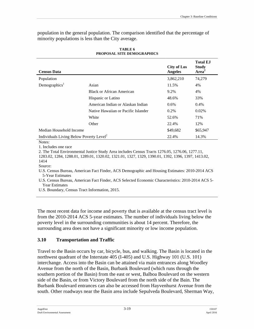
Chapter 3: Baseline Conditions
AngelFest 3-19 150107
Draft Environmental Assessment April 2016
population in the general population. The comparison identified that the percentage of minority populations is less than the City average.
TABLE 6 PROPOSAL SITE DEMOGRAPHICS
Census Data City of Los Angeles
Total EJ Study Area2
Population 3,862,210 74,279
Demographics1 Asian 11.5% 4%
Black or African American 9.2% 4%
Hispanic or Latino 48.6% 33%
American Indian or Alaskan Indian 0.6% 0.4%
Native Hawaiian or Pacific Islander 0.2% 0.02%
White 52.6% 71%
Other 22.4% 12%
Median Household Income $49,682 $65,947
Individuals Living Below Poverty Level2 22.4% 14.3% Notes: 1. Includes one race 2. The Total Environmental Justice Study Area includes Census Tracts 1276.05, 1276.06, 1277.11, 1283.02, 1284, 1288.01, 1289.01, 1320.02, 1321.01, 1327, 1329, 1390.01, 1392, 1396, 1397, 1413.02, 1414 Source: U.S. Census Bureau, American Fact Finder, ACS Demographic and Housing Estimates: 2010-2014 ACS
5-Year Estimates U.S. Census Bureau, American Fact Finder, ACS Selected Economic Characteristics: 2010-2014 ACS 5-
Year Estimates U.S. Boundary, Census Tract Information, 2015.
The most recent data for income and poverty that is available at the census tract level is from the 2010-2014 ACS 5-year estimates. The number of individuals living below the poverty level in the surrounding communities is about 14 percent. Therefore, the surrounding area does not have a significant minority or low income population. 3.10 Transportation and Traffic Travel to the Basin occurs by car, bicycle, bus, and walking. The Basin is located in the northwest quadrant of the Interstate 405 (I-405) and U.S. Highway 101 (U.S. 101) interchange. Access into the Basin can be attained via main entrances along Woodley Avenue from the north of the Basin, Burbank Boulevard (which runs through the southern portion of the Basin) from the east or west, Balboa Boulevard on the western side of the Basin, or from Victory Boulevard from the north side of the Bain. The Burbank Boulevard entrances can also be accessed from Hayvenhurst Avenue from the south. Other roadways near the Basin area include Sepulveda Boulevard, Sherman Way,
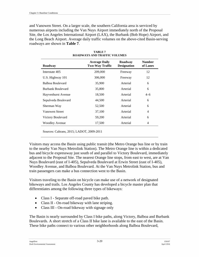
Chapter 3: Baseline Conditions
AngelFest 3-20 150107
Draft Environmental Assessment April 2016
and Vanowen Street. On a larger scale, the southern California area is serviced by numerous airports including the Van Nuys Airport immediately north of the Proposal Site, the Los Angeles International Airport (LAX), the Burbank (Bob Hope) Airport, and the Long Beach Airport. Average daily traffic volumes on the above-cited Basin-serving roadways are shown in Table 7.
TABLE 7 ROADWAYS AND TRAFFIC VOLUMES
Roadway Average Daily
Two-Way Traffic Roadway
Designation Number of Lanes
Interstate 405 209,000 Freeway 12
U.S. Highway 101 306,000 Freeway 12
Balboa Boulevard 35,900 Arterial 6
Burbank Boulevard 35,800 Arterial 6
Hayvenhurst Avenue 18,500 Arterial 4–6
Sepulveda Boulevard 44,500 Arterial 6
Sherman Way 52,500 Arterial 6
Vanowen Street 37,100 Arterial 4
Victory Boulevard 59,200 Arterial 6
Woodley Avenue 17,500 Arterial 4
Sources: Caltrans, 2015; LADOT, 2009-2011
Visitors may access the Basin using public transit (the Metro Orange bus line or by train to the nearby Van Nuys Metrolink Station). The Metro Orange line is within a dedicated bus and bicycle expressway just south of and parallel to Victory Boulevard, immediately adjacent to the Proposal Site. The nearest Orange line stops, from east to west, are at Van Nuys Boulevard (east of I-405), Sepulveda Boulevard at Erwin Street (east of I-405), Woodley Avenue, and Balboa Boulevard. At the Van Nuys Metrolink Station, bus and train passengers can make a bus connection west to the Basin. Visitors traveling to the Basin on bicycle can make use of a network of designated bikeways and trails. Los Angeles County has developed a bicycle master plan that differentiates among the following three types of bikeways:
Class I - Separate off-road paved bike path. Class II - On-road bikeway with lane striping. Class III - On-road bikeway with signage only
The Basin is nearly surrounded by Class I bike paths, along Victory, Balboa and Burbank Boulevards. A short stretch of a Class II bike lane is available to the east of the Basin. These bike paths connect to various other neighborhoods along Balboa Boulevard,
Chapter 3: Baseline Conditions
AngelFest 3-21 150107
Draft Environmental Assessment April 2016
Woodley Avenue, and Oxnard Street. For visitors who prefer to walk to the Basin, there are continuous sidewalks on most connecting streets. Emergency vehicles can access the Basin through the main public access nodes along Woodley Avenue, Burbank Boulevard, Balboa Boulevard, or Victory Boulevard. The two Burbank Boulevard entrances can also be accessed from Hayvenhurst Avenue to the south. 3.11 Utilities There are several water lines that run though the Sepulveda Dam Basin Recreational Area within close proximity of the Proposed Project Site. According to the Master Plan, Map 26 Utilities, a water line runs along the western border of the Proposed Project Site, parallel to Woodley Creek and turns east to connect to the TWRP, located north of the Proposed Project Site. Another water line runs parallel to the Hayvenhurst Channel and through the Woodley Lakes Golf Course. 3.12 Aesthetics The Sepulveda Dam Basin and Recreation Area contain major visual features including the Los Angeles River, Sepulveda Dam, Lake Balboa, adjacent parks, golf courses, and the Wildlife areas. The Los Angeles River is a channelized waterway that passes through the center of the Basin, and is characterized by native and non-native vegetation. The Sepulveda Dam outlet structure is visible from the southeastern areas of the Basin. The outlet structure is a large concrete structure that rises above the landscape. Lake Balboa is a man-made lake surrounded by maintained lawns and ornamental trees. The Sepulveda Basin Wildlife Area in the eastern area of the Basin is characterized by scrub vegetation and a man-made lake. Views in this area are short-range due to trees, except to the west of Woodley Avenue, where mid-range views sweep over the scrub shrub habitat below the model airplane airspace. There are few long-range views within the Basin that are suitable as overlooks, primarily because of the presence of tall trees and the absence of elevated areas. Burbank Boulevard passes over the Dam into the Basin near the southeastern corner, providing a long range view of the Los Angeles River, Sepulveda Dam, Lake Balboa, and the Sepulveda Basin Wildlife Area. Woodley Park is characterized by grassy fields and trees with picnic bench areas, restroom building facilities, and a parking lot. The TWRP is immediately north of and visible from Woodley Park. Part of the TWRP is the Japanese Garden, which includes a 6.5-acre garden with a dry Zen meditation garden, arrangement of stones, and a wisteria arbor across a Plover path. It also includes a garden with waterfalls, lakes, streams, stone lanterns, and a tea house. The Japanese Garden is fenced off and surrounded by trees and the TWRP; therefore, it is not fully visible from the Proposed Project Site or the surrounding area, except partially from its parking lot. The cricket fields are grass lawns bordered by a dirt field to the north, Haskell Creek to the east, Woodley Park to the south, and the TWRP to the west. The archery range is an
Chapter 3: Baseline Conditions
AngelFest 3-22 150107
Draft Environmental Assessment April 2016
open field east of Haskell Creek with a small building. The northern portion of the Wildlife Area is currently landscaped with grass sod, trees and contains walking paths/trails, paved access roads and parking areas. Views of the southern portion of the Sepulveda Basin Wildlife Area include an expanse of scrub vegetation west of Woodley Avenue and a manmade lake and additional acreage of scrub vegetation. 3.13 Recreation Resources The Sepulveda Dam Recreational Area consists of the Balboa Sports Center, Hjelte Sports Center, Lake Balboa/Anthony C. Beilenson Park, Sepulveda Garden Center, Sherman Oaks Castle Park, Woodley Park, Encino Golf Course, Balboa Golf Course, and Woodley Lakes Municipal Golf Course. The Proposed Project Site consists of Woodley Park, cricket fields, archery range, the Japanese Garden including its parking lot, and the Sepulveda Basin Wildlife Area (northern portion). Onsite parking areas would include the model airplane field, Balboa Sports Center, Sepulveda Basin Sports Complex, and the Woodley Lake Municipal Golf Course. During the month of October, it is estimated that on a typical Friday, Saturday and Sunday, an average of 1,600 people per day use Woodley Park, a total of 5,000 users during the three (3) -day period, from sunrise to sundown. An estimated 167 users per day, a total of 500 people would utilize the cricket fields during the same three (3) day period. An average of 67 people per day would use the archery range, a total of 200 people, and an average of 100 users per day would be expected to use the model airplane field, a total of 300 people over the three (3) day period, from sunrise to sundown (Loomis, 2015). The Japanese Garden is closed on Fridays and Saturdays. 248 people visit the Japanese Garden specifically on Sundays (Green, 2016). During the month of October, it is estimated that on a typical Friday, Saturday, and Sunday, an average of 425 people use the Woodley Lake Municipal Golf Course per weekend day (Manukyan, 2016). There are both programmed and passive recreational uses within the Sepulveda Dam Basin Recreation Area on a daily basis. Programmed recreational uses typically include use of the golf course and use of the archery range and cricket fields. Passive recreation uses include use of playgrounds, picnic areas, and walking paths/trails. In addition to the daily recreational uses that occur at the aforementioned recreational areas, Woodley Park hosts special events at various times throughout the year. 3.14 Public Health and Safety Public health and safety focuses on the potential risks to the public from hazards that may occur within the Proposed Project Site or may impact public services adjacent to the Proposed Project Site. Health and safety hazards to the public can evolve from recreation uses, plants and wildlife, flooding, hazardous materials, and criminal activity. Nearby public services, such as law enforcement, fire protection, hospitals, and schools, may be dependent on access through the Proposed Project Site, designated as respondents to health and safety issues, or be impacted by activities within the Proposed Project Site.
Chapter 3: Baseline Conditions
AngelFest 3-23 150107
Draft Environmental Assessment April 2016
3.14.1 Floodplain Management The potential hazard posed by the flood risk within the Basin is of primary concern for any activities within the Basin. The Corps manages the Basin to facilitate periodic inundation so as to hold back flood waters and prevent flooding in downstream communities. Land use within the basin is managed to preserve uses compatible with inundation and to avoid activities and development that could harm the primary operation for flood risk management. Because the Proposed Project Site is located within the Basin, its overall purpose of being used for flood risk management is paramount. The Basin’s flood frequency elevations corresponding to the 1 percent (100-year), 2 percent (50-year), and 10 percent (10-year) annual exceedance probability events are shown in Map 16 of the Sepulveda Dam Basin Master Plan. There is no human habitation allowed within the overall Basin and existing structures and improvements are either floodable, flood-proofed, or protected by flood walls up to at least the base flood (100 year) elevation. Most of the Japanese Garden and Archery Range fall within the 100-year floodplain annual exceedance probability event (some parts are located in the 50-year floodplain). The Woodley Parks (I, II, and III), Cricket Fields, and Woodley Lakes Municipal Golf Course largely fall within the 50-year floodplain, with some parts falling within the 10-year floodplain. The Model Airplane Field and most of the Sepulveda Basin Wildlife Area fall within the 10-year flood plain. During storm and flood events, inflow to the Basin can create hazardous conditions related to flowing water (such as fast-moving, high water levels in the area, closure of roads including exit routes, water sweeping debris or people downstream), erosion of soil from streambanks, inundation of Basin lands, and potential for Dam failure. A risk-based evaluation of the Corps’ dams nation-wide was prepared and the dams were classified into Dam Safety Action Classes (DSAC). The classifications were based on event probability, probability of failure, and consequences given the physical properties of the Dam. The Sepulveda Dam is a DSAC 3 out of 5, with 5 having the lowest risk level. Rainfall events exceeding 0.5 inches in a day cause rapid increases in water surface within the Basin that are a potential hazard to recreational users. For example, events exceeding 0.5 inches of rain have been observed to cause water in the basin to rise by more than 20 feet in 18 hours. Between 1931 and 2015, rainfall events in the Upper Los Angeles River Watershed exceeding 0.5 inches of rain per day have been recorded as having occurred 8 times in the first 16 days of October, with an average probability of occurring in any given year of approximately 10 percent. The probability of a rain event greater than 0.5 inches occurring within a three day window in the first two weeks of October such as the Columbus Day weekend is 2 percent per year.
Chapter 3: Baseline Conditions
AngelFest 3-24 150107
Draft Environmental Assessment April 2016
3.14.2 Emergency Responders Onsite law enforcement at the recreation amenities within the Basin is provided by the City of Los Angeles, Department of General Services – Office of Public Safety, which is headquartered at Griffith Park, and the LAPD. The nearest law enforcement services are located at the LAPD West Valley Police Station at 19020 Vanowen Street, approximately 2.5 miles northwest from the Proposal Site. According to the Los Angeles Fire Department (LAFD) and the City of LA Zoning Maps System, the Proposed Project Site is located outside of a wildfire hazard area, and is not located within a Very High Fire Severity Zone (City of Los Angeles, 1996; ZIMAS, 2015). The Proposal Site does contain some naturally vegetated areas that are susceptible to wildfire. This includes the model airplane field, which experiences fairly regular fires that are controlled and generally not extinguished to by the local fire department. Fire protection and emergency medical services are provided by the LAFD Fire Station 39 is located at 14415 Sylvan Street, approximately 1.8 miles east from the Proposed Project Site. LAFD Fire Station 39 is also nearby, located within two miles of the Proposed Project Site. Emergency room and Hospital services are found at Valley Presbyterian Hospital in Van Nuys approximately 1 mile east of the Proposed Project Site. Table 8 lists the public services that are located closest and serve as primary responders to the Proposal Site. 3.15 Sustainability Sustainability can be broadly defined as “meeting the needs of the present generation without compromising the ability of future generations to meet their own needs.” This definition takes into account that there are three “spheres” comprising sustainability (environmental, economic, and social) that need to be considered when developing and evaluating projects and management systems. For the Corps, applying the goals inherent in this definition to the development and implementation of Corps and Corps co-sponsored projects involves approaching the planning, design, construction, and operation phases of these projects with the intention of sustaining natural resources, protecting the environment, achieving economic viability, and promoting a high quality of life. The TWRP discharges advanced tertiary-treated water and this water is used throughout the Basin. From the water in Lake Balboa to irrigation of the golf greens and finally discharge to the Los Angeles River, the discharge from the reclamation plant irrigates the entire recreation area within the Basin. Recognizing the value of the recycled water, as irrigation is upgraded, “smart irrigation” is being installed that irrigates only the amount that is needed on the landscape.
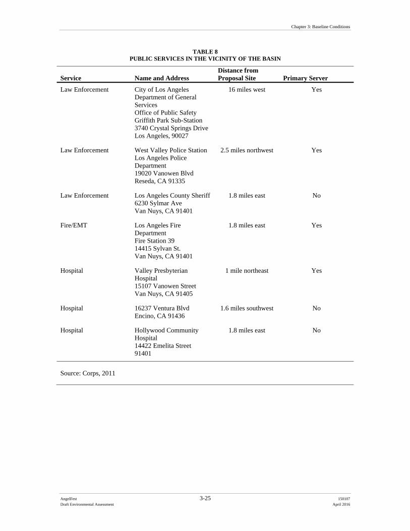
Chapter 3: Baseline Conditions
AngelFest 3-25 150107
Draft Environmental Assessment April 2016
TABLE 8 PUBLIC SERVICES IN THE VICINITY OF THE BASIN
Service Name and Address Distance from Proposal Site Primary Server
Law Enforcement City of Los Angeles Department of General Services Office of Public Safety Griffith Park Sub-Station 3740 Crystal Springs Drive Los Angeles, 90027
16 miles west Yes
Law Enforcement West Valley Police Station Los Angeles Police Department 19020 Vanowen Blvd Reseda, CA 91335
2.5 miles northwest Yes
Law Enforcement Los Angeles County Sheriff6230 Sylmar Ave Van Nuys, CA 91401
1.8 miles east No
Fire/EMT Los Angeles Fire Department Fire Station 39 14415 Sylvan St. Van Nuys, CA 91401
1.8 miles east Yes
Hospital Valley Presbyterian Hospital 15107 Vanowen Street Van Nuys, CA 91405
1 mile northeast Yes
Hospital 16237 Ventura Blvd Encino, CA 91436
1.6 miles southwest No
Hospital Hollywood Community Hospital 14422 Emelita Street 91401
1.8 miles east No
Source: Corps, 2011

AngelFest 4-1 150107
Draft Environmental Assessment April 2016
CHAPTER 4
Alternatives Impacts Assessment
4.1 Physical Land Resources 4.1.1 Thresholds of Significance A significant impact could occur to physical land resources if the Proposed Action would:
Significantly increase wind or water erosion of soils or loss of topsoil, either on or off the site;
Result in substantial adverse effect to people or structures from earthquakes or related ground shaking.
4.1.2 Proponent’s Preferred Alternative 4.1.2.1 Erosion During Festival setup the model airplane field north of the runway area and the corn maze would be mowed and raked, consistent with regular RAP vegetation management of this area. The RAP regularly conducts hammer knife mowing twice a year at most. These areas would only be cleared once prior to the Festival, in order to limit ground disturbance. Although some subsurface activity would occur from posting fencing, no subsurface disturbance would occur to the extent that underlying soils and vegetation root systems would disturbed. Subject to BOS approval (which has been requested by RAP), the area north of the cricket fields and east of the TWRP, south of the septic tank disposal area, and west of Haskell Creek would be cleared of debris and raked in a similar fashion as described above. The northeast corner of the Basin adjacent to and, north of the archery ranges would be similarly cleared of debris, mowed, and raked. There would be no subsurface earthwork (except chain link fence post installation).There would be no alteration of subsurface geology, so there would be no potential for alteration related to chemical soil properties, geologic features, or minerals. The three (3)-day Festival would occur on areas of the Proposed Project Site that generally consist of pervious ground cover surfaces (mainly grassy areas). These types of surfaces host large events without resulting in substantial soil exposure or erosion. The proposed activities within the Proposed Project Site would be temporary and short-term in nature (with most potential for impacts occurring over the three (3)–day Festival. Parking on grassy areas would not result in a significant impact regarding erosion due to
Chapter 4: Chapter 4: Alternatives Impacts Assessment
AngelFest 4-2 150107
Draft Environmental Assessment April 2016
the limited length of time the unpaved areas would be used for parking and planned restoration activities. While foot traffic on grassy areas from the Festival are not anticipated to result in substantial soil exposure or soil erosion (and given the unlikely possibility of a significant erosion-inducing rain storm given the time of year), given the scope of the event, including the number of attendees, equipment anticipated, and vehicle traffic on grassy areas, some compaction, exposure of bare soil, and potential for erosion is anticipated, though impacts would be less than significant. Parking on grassy areas would not result in a significant impact from potential erosion due to the limited length of time that the unpaved areas would be used for parking. Impacts after the Festival from teardown and restoration activities are likewise anticipated to be less than significant. Due to the timing of the event at the onset of the flood season, there is a remote risk that areas would be exposed due to foot or vehicle traffic or other disturbances associated with the teardown and restoration after the event. Reestablishment to prevent further soil exposure and erosion would be ensured by conducting the efforts in conformance with RAP practice, which has ongoing experience in managing the turf year round. Even in a worst case that certain areas take longer to reestablish turf than others, these would be isolated conditions that would not result in substantial erosion.
To further minimize any potential impacts regarding erosion, several environmental commitments (PLR-1 through PLR-6) would be implemented (see Section 4.1.5 and Appendix D).
4.1.2.2 Ground shaking In the event that an earthquake was to occur during the Festival, the Proposed Project Site, as well as the larger surrounding region, could be susceptible to earthquake related ground shaking. The Festival would be staffed by dozens of security, police, and emergency responders who would be available to assist in the remote chance that earthquake related response is needed. To further minimize any potential impacts, environmental commitment PLR-7, listed in Section 4.1.5 and in Appendix D, would be implemented. As such, there would be no impacts related to ground shaking. 4.1.3 Alternative 2 This alternative is within the same geological formation and provides similar physical characteristics as the Proponent’s Preferred Alternative. The physical conditions in relation to geology and soils are comparable. The impacts of Alternative 2 would less than significant with respect to physical land resources. Since Festival goers would walk to the Festival via the maintenance road along the south side of the Los Angeles River to Burbank Boulevard and north on Woodley Avenue, accidental erosion of side slopes could be caused, falling into the Los Angeles River.

Chapter 4: Alternatives Impacts Assessment
AngelFest 4-3 150107
Draft Environmental Assessment April 2016
4.1.4 No Action Alternative Under the No Action Alternative, the Proposed Action would not occur and no impacts to physical land resources, such as erosion would increase beyond normal use of the area. The potential for unpredictable earthquakes remains, with potential magnitude that could cause land damages. 4.1.5 Environmental Commitments The following environmental commitments would be in place to further minimize any impacts to physical land resources. PLR-1 The Proponent will water all unpaved areas to minimize soil erosion as
needed. All unpaved areas will be watered down prior to opening for use each day to minimize fugitive dust.
PLR-2 To reduce potential erosion, areas disturbed by the event would be immediately returned to pre-event conditions by re-vegetating as appropriate. As necessary to restore prior conditions, barren areas would be seeded and/or planted with native vegetation.
PLR-3 Areas along Woodley Creek and Haskell Creek will be fenced to ensure no substantial erosion affects the sensitive waterways.
PLR-4 No ground disturbing activities (other than fence posting) within the sensitive wildlife areas will occur.
PLR-5 Double fencing to ensure no access along the boundaries of Haskell Creek and to protect the adjacent Sepulveda Basin Wildlife Area will be implemented to protect sensitive areas from potential erosion.
PLR-6 Grading and construction activities shall not be conducted during a rain event. Workers and equipment shall be removed from the area until the cessation of rain.
PLR-7 Emergency access routes will be identified as part of the development of the emergency response plan based on input from emergency responders to address an emergency such as an earthquake.
4.2 Water Resources 4.2.1 Thresholds of Significance A significant impact could occur to water resources if the Proposed Action would:
Expose people or structures to a significant risk of loss, injury, or death involving flooding.
Cause a violation of any water quality standard or waste discharge requirement, or otherwise substantially degrade water quality.
Chapter 4: Chapter 4: Alternatives Impacts Assessment
AngelFest 4-4 150107
Draft Environmental Assessment April 2016
4.2.2 Proponent’s Preferred Alternative 4.2.2.1 Floodplain Management The entire Basin is subject to rapid onset flooding. However, the Proposed Project Site is situated mainly at higher elevation areas that are not as susceptible to flooding. As described in Section 3.5, rainfall events exceeding 0.5 inches in a day cause rapid increases in water surface within the Basin that are a potential hazard to users. For example, events exceeding 0.5 inches of rain have been observed to cause water in the basin to rise by more than 20 feet in 18 hours. Setup for the Festival would begin in mid-late September 2016, and continue until the beginning of the Festival in early October 2016. Breakdown activities would continue until mid-October. The Festival would be held at the very beginning of the water year (begins in October and the Festival is the first week of October). The location of the Festival itself is mostly within the 50- or 100-year floodplain within the Basin, but parts are within the 10-year floodplain. Between 1931 and 2015, rainfall events in the Upper Los Angeles River Watershed exceeding 0.5 inches of rain per day have occurred 8 times in the first 15 days of October, with an average probability of occurring in any given year of approximately 10 percent. As noted in Section 3.13, the probability of a rain event greater than 0.5 inches occurring within a three day window in the first two weeks of October such as the Columbus Day weekend is 2 percent per year. Given the rapid nature of flooding that can occur in the Basin, the Corps requires that evacuation plans for the Basin include rainfall monitoring of the National Oceanic and Atmospheric Administration (NOAA) Quantitative Precipitation Forecast (QPF) with potential for evacuation where forecast events exceed 0.5 inches of rain in a day. As described as part of the Proponent’s Preferred Alternative (Section 2.3.1.14), an evacuation/emergency response plan will be prepared for the Festival, led by emergency response providers (LAPD/LAFD) (Environmental Commitment (EC) WR-2). This would also include are requirement that all activities will be suspended if a rain event is forecast of 0.5 inches or greater in any 24-hour period for any of the event days, including all days of setup, the three (3) Festival days, or the breakdown days (EC WR-3). In addition, parking locations were chosen based on floodplain elevation, and parking in the areas lowest in the Basin would not be allowed. Overall, there would be no significant impact with respect to flooding, and EC WR-1 through WR-3 would further minimize any potential impacts. 4.2.2.2 Water Quality The Proponent’s Preferred Alternative would not involve any changes to the landscape or surfaces such that surface water runoff/drainage patterns, groundwater characteristics, or erosion rates would be altered. The most substantial impact to water resources from the implementation of the Proposed Project Site is the potential effects to water quality that would come from its contributions to runoff or littering. Currently, the Proposed Project Site is located primarily within Woodley Park, which utilizes recycled (gray) water reclaimed from the adjacent TWRP for irrigation and maintenance purposes. The Festival
Chapter 4: Alternatives Impacts Assessment
AngelFest 4-5 150107
Draft Environmental Assessment April 2016
plans on utilizing the same water resource where possible, such as for dust control, irrigation, and general cleaning, in accordance with Los Angeles County and State of California public health regulations. Thus, the Proponent’s Preferred Alternative would not be introducing a new source of water that could potentially affect the water quality within the existing water resources. The setup of the Festival does not involve any permanent construction or substantial excavation, beyond some minor grading north of the cricket fields and north of the archery range, so groundwater and surface water supplies would not be affected and runoff from construction-related activities are not anticipated. Possible contaminants that could affect the water resources are debris from employees and attendees throughout the construction and operation of the Festival. However, a temporary six foot high chain-link fence would be installed around the Proposed Project Site that would be used to prevent debris from being tossed into Haskell Creek (EC WR-4). Fencing along Haskell Creek and Woodley Creek, which are interior to the Proposed Project Site, would run along the length of the water features (with limited designated spots for attendees to pass through), and there would be no access to the Creeks by event staff or Festival attendees during the Festival. In order to prevent access to Haskell Creek and Woodley Creek, the fencing would be fabric covered double-fence. Event staff would only access the water features in the event that minor litter removal is required from the water features during Festival breakdown. The 12 acre Wildlife Lake would not be significantly affected by the Festival setup or attendees because it would be off-limits. Similarly, the Los Angeles River is located south of the Proposed Project Site, more than 2,600 feet from any Festival activities. Even if there is a rain event, when materials could be carried down to the Los Angeles River, silt fencing around the Festival boundary (EC WR-4) would minimize potential debris. Environmental Commitments WR-4 through WR-6 will further minimize any potential impacts to water quality. 4.2.3 Alternative 2 The physical conditions in relation to water resources are generally comparable to the above. With Festival goers using the maintenance road along the south side of the Los Angeles River to Burbank Boulevard, and north on Woodley Avenue, there is an increased likelihood of trash and debris being thrown into the Los Angeles River during the three (3) days of the Festival. Festival goers returning to their cars at night would have a greater chance of accidentally falling or being pushed into the Los Angeles River. Addition security guards would be required for this area as well as additional fencing along the Los Angeles River. 4.2.4 No Action Alternative Under the No Action Alternative, no physical changes to the Proposed Project Site would occur nor would human use or maintenance activities change. Additionally, groundwater usage and recharge would not be harmed. The water quality is expected to continue to diminish with population growth and increase in visitation growth.

Chapter 4: Chapter 4: Alternatives Impacts Assessment
AngelFest 4-6 150107
Draft Environmental Assessment April 2016
4.2.5 Environmental Commitments The following environmental commitments would be in place to further minimize impacts to water resources. WR-1 To minimize potential impacts should a rain event occur, the setup and
breakdown will be phased to the extent feasible such that areas in lower parts of the Basin, which are more susceptible to flooding, will be installed last and removed first, thus minimizing the time floatable debris is located in the lowest parts of the Basin. Locations of port-o-johns will also be located in areas of higher elevations to the extent feasible.
WR-2 The Festival Proponent or organizer (RAP or Make Good Group) will prepare a final evacuation/emergency response plan in coordination with emergency response providers (LAPD/LAFD) and the Corps’ Safety Office. The plan will include rainfall monitoring of the National Oceanic and Atmospheric Administration (NOAA) Quantitative Precipitation Forecast (QPF) with potential for evacuation where forecast events exceed 0.5 inches of rain in a day. The plan will be consistent with Corps’ Engineer Manual 385-1-1, where applicable. The plan will address all protocols for response to public safety matters including weather, an accidental hazardous material exposure, earthquakes, early warning intelligence indicating the potential need to evacuate, and other conditions. The plan will be developed during the detailed planning phase of the Festival as directed by the emergency responders. The emergency response plan will include, for example:
Evacuation details and routes for various emergency scenarios; Rain forecast event cancellation details; How emergency announcements will be broadcasted; How the shuttle system could be utilized as part of the evacuation process; Setup and breakdown procedures in the event of a significant emergency;
and Human health emergency response.
WR-3 Consistent with the evacuation/emergency response plan to be prepared (EC WR-2), RAP and the Festival Proponent will be immediately notified and all activities will be suspended if a rain event is forecast of 0.5 inches or greater in any 24-hour period for any of the event days, including all days of setup, the three (3) Festival days, or the breakdown days.
WR-4 A temporary six foot high chain-link fence will be installed around the Proposed Project Site to prevent debris from being tossed into Haskell Creek. Fencing along Haskell Creek and Woodley Creek, which are interior to the Proposed Project Site, will run along the length of the water features through the entirety within the Proposed Project Site, and there would be no access by event staff or Festival attendees during the Festival. There will be limited designated spots where attendees can pass through. Silt fencing will be placed
Chapter 4: Alternatives Impacts Assessment
AngelFest 4-7 150107
Draft Environmental Assessment April 2016
along the Festival boundary to minimize debris being washed into the Los Angeles River.
WR-5 Complete litter removal would be conducted within the affected water features including Haskell Creek and the Wildlife Area Lake in coordination with and under the direction of the RAP and the Corps.
WR-6 Fluids released because of spills, equipment failure (broken hose, punctured tank) or refueling will be immediately controlled, contained, and cleaned-up per Federal and state regulations. All contaminated materials will be disposed of promptly and properly to prevent contamination of the site.
4.3 Air Quality 4.3.1 Thresholds of Significance There could be significant impacts to air quality if the Proposed Action would:
Result in non-compliance with the Federal General Conformity Rule (40 CFR Parts 6, 51, and 93) Requirements;
Exceed 25,000 metric tons of CO2e or otherwise substantially negatively contribute to the effects of climate change;
Exceed any Federal de minimis thresholds for any criteria pollutant for which the project region is non-attainment under an applicable federal ambient air quality standard (including releasing emissions that exceed quantitative thresholds for ozone precursors);
Expose the public (especially schools, day care centers, hospitals, retirement homes; convalescence amenities, and residences) to substantial pollutant concentrations; and/or
Create objectionable odors affecting a substantial number of people. 4.3.2 Proponent’s Preferred Alternative 4.3.2.1 Criteria Pollutant Emissions The General Conformity Rule ensures that the actions taken by Federal agencies in nonattainment and maintenance areas do not interfere with a state’s plans to meet the NAAQS for criteria pollutants and are consistent with the air quality plans established in the applicable state implementation plans (SIP) for these pollutants. Implementation of the General Conformity Regulations fall into three phases: applicability analysis, conformity determination, and review process. The regulations recognize that the vast majority of Federal actions do not result in a significant increase in emissions and, therefore, include a number of exemptions, the most predominantly implemented of which is the de minimis emission levels based on the type and severity of the nonattainment problem. If a proposed action would cause emissions above the de minimis level in any nonattainment or maintenance area and the action is not otherwise exempt, “presumed to conform,” or included in the existing emissions budget of the SIP, then the
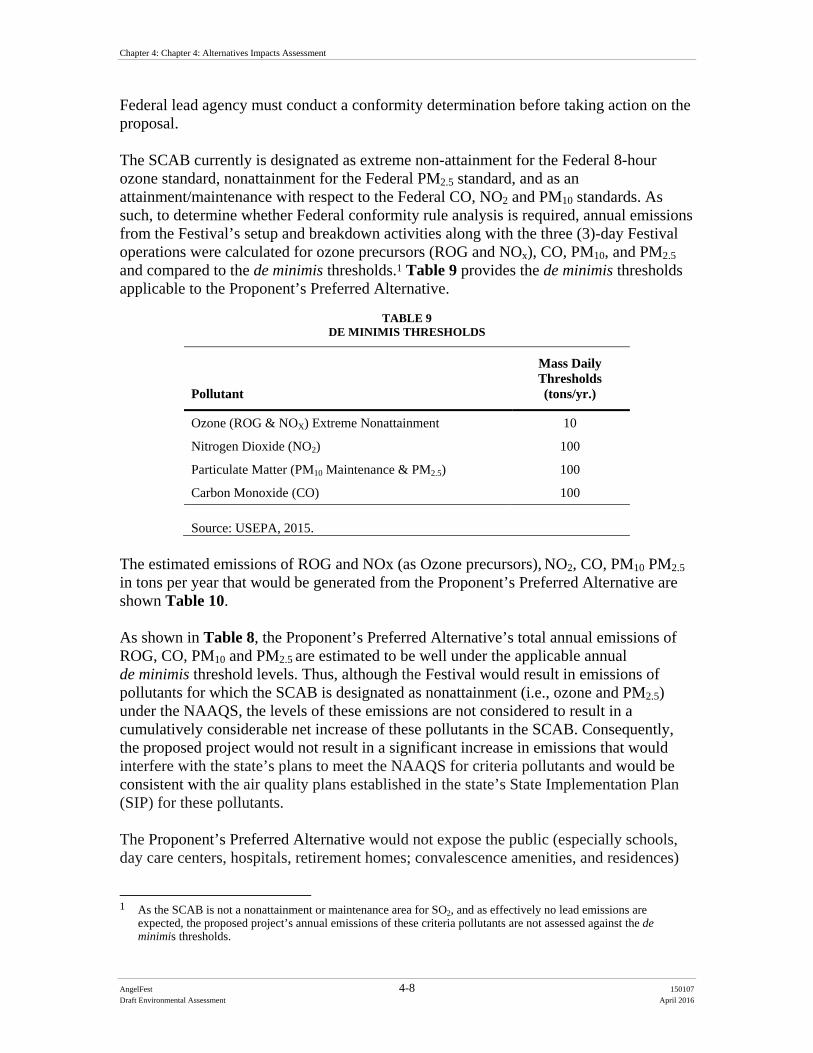
Chapter 4: Chapter 4: Alternatives Impacts Assessment
AngelFest 4-8 150107
Draft Environmental Assessment April 2016
Federal lead agency must conduct a conformity determination before taking action on the proposal. The SCAB currently is designated as extreme non-attainment for the Federal 8-hour ozone standard, nonattainment for the Federal PM2.5 standard, and as an attainment/maintenance with respect to the Federal CO, NO2 and PM10 standards. As such, to determine whether Federal conformity rule analysis is required, annual emissions from the Festival’s setup and breakdown activities along with the three (3)-day Festival operations were calculated for ozone precursors (ROG and NOx), CO, PM10, and PM2.5 and compared to the de minimis thresholds.1 Table 9 provides the de minimis thresholds applicable to the Proponent’s Preferred Alternative.
TABLE 9 DE MINIMIS THRESHOLDS
Pollutant
Mass Daily Thresholds (tons/yr.)
Ozone (ROG & NOX) Extreme Nonattainment 10
Nitrogen Dioxide (NO2) 100
Particulate Matter (PM10 Maintenance & PM2.5) 100
Carbon Monoxide (CO) 100
Source: USEPA, 2015.
The estimated emissions of ROG and NOx (as Ozone precursors), NO2, CO, PM10 PM2.5
in tons per year that would be generated from the Proponent’s Preferred Alternative are shown Table 10. As shown in Table 8, the Proponent’s Preferred Alternative’s total annual emissions of ROG, CO, PM10 and PM2.5 are estimated to be well under the applicable annual de minimis threshold levels. Thus, although the Festival would result in emissions of pollutants for which the SCAB is designated as nonattainment (i.e., ozone and PM2.5) under the NAAQS, the levels of these emissions are not considered to result in a cumulatively considerable net increase of these pollutants in the SCAB. Consequently, the proposed project would not result in a significant increase in emissions that would interfere with the state’s plans to meet the NAAQS for criteria pollutants and would be consistent with the air quality plans established in the state’s State Implementation Plan (SIP) for these pollutants. The Proponent’s Preferred Alternative would not expose the public (especially schools, day care centers, hospitals, retirement homes; convalescence amenities, and residences)
1 As the SCAB is not a nonattainment or maintenance area for SO2, and as effectively no lead emissions are
expected, the proposed project’s annual emissions of these criteria pollutants are not assessed against the de minimis thresholds.
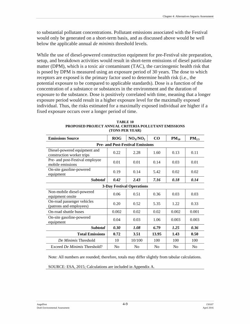
Chapter 4: Alternatives Impacts Assessment
AngelFest 4-9 150107
Draft Environmental Assessment April 2016
to substantial pollutant concentrations. Pollutant emissions associated with the Festival would only be generated on a short-term basis, and as discussed above would be well below the applicable annual de minimis threshold levels. While the use of diesel-powered construction equipment for pre-Festival site preparation, setup, and breakdown activities would result in short-term emissions of diesel particulate matter (DPM), which is a toxic air contaminant (TAC), the carcinogenic health risk that is posed by DPM is measured using an exposure period of 30 years. The dose to which receptors are exposed is the primary factor used to determine health risk (i.e., the potential exposure to be compared to applicable standards). Dose is a function of the concentration of a substance or substances in the environment and the duration of exposure to the substance. Dose is positively correlated with time, meaning that a longer exposure period would result in a higher exposure level for the maximally exposed individual. Thus, the risks estimated for a maximally exposed individual are higher if a fixed exposure occurs over a longer period of time.
TABLE 10 PROPOSED PROJECT ANNUAL CRITERIA POLLUTANT EMISSIONS
(TONS PER YEAR)
Emissions Source ROG NOX/NO2 CO PM10 PM2.5
Pre- and Post-Festival Emissions Diesel-powered equipment and construction worker trips
0.22 2.28 1.60 0.13 0.11
Pre- and post-Festival employee mobile emissions
0.01 0.01 0.14 0.03 0.01
On-site gasoline-powered equipment
0.19 0.14 5.42 0.02 0.02
Subtotal 0.42 2.43 7.16 0.18 0.14
3-Day Festival Operations Non-mobile diesel-powered equipment onsite
0.06 0.51 0.36 0.03 0.03
On-road passenger vehicles (patrons and employees)
0.20 0.52 5.35 1.22 0.33
On-road shuttle buses 0.002 0.02 0.02 0.002 0.001 On-site gasoline-powered equipment
0.04 0.03 1.06 0.003 0.003
Subtotal 0.30 1.08 6.79 1.25 0.36
Total Emissions 0.72 3.51 13.95 1.43 0.50
De Minimis Threshold 10 10/100 100 100 100
Exceed De Minimis Threshold? No No No No No Note: All numbers are rounded; therefore, totals may differ slightly from tabular calculations. SOURCE: ESA, 2015; Calculations are included in Appendix A.
Chapter 4: Chapter 4: Alternatives Impacts Assessment
AngelFest 4-10 150107
Draft Environmental Assessment April 2016
According to the Office of Environmental Health Hazard Assessment, carcinogenic health risk assessments, which determine the exposure of sensitive receptors to TAC emissions, should be based on a 30-year exposure period; however, such assessments should be limited to the period or duration of activities associated with proposed site restoration. As the pre-Festival site preparation, setup, and breakdown activities would only occur over an approximately a three-week period and would be substantially less than the 30-year period used for risk determination, the emissions of TACs generated by the proposed project would be negligible and would not expose sensitive receptors to substantial emissions of TACs. Overall, the short-term emissions generated by the Proponent’s Preferred Alternative would not have an adverse effect on air quality. 4.3.2.2 Dust Localized emissions could be generated during the Festival by vehicles traveling to the Proposed Project Site and parking in unpaved parking areas and by general pedestrian foot traffic within the Festival. Dust control would be conducted as needed throughout the Proposed Project Site and unpaved parking areas. All unpaved areas would be watered down prior to opening for use each day (EC PLR-1). The majority of the Proposed Project Site is landscaped with grass; therefore, there would be a low potential for dust to be generated within the Proposed Project Site. Any dust that is generated would be temporary and localized. EC AQ-1 will further minimize dust impacts. 4.3.2.3 Odors Substantial odor-generating sources are generally associated with land uses such as agricultural activities, feedlots, wastewater treatment facilities, landfills or various heavy industrial uses. The Proponent’s Preferred Alternative does not propose any such uses or activities that would result in adverse effects associated with odors. Potential sources of operational odors at the Proposed Project Site during the three (3)-day Festival would include food preparation by vendors, disposal of miscellaneous refuse, and disposal of vendor food wastes. While odors may also be generated by the on-site generators used to power the Festival operations, these generators would all be powered by solar and bio-fuel, which typically does not produce odors that are considered to be objectionable. As all refuse generated at the Proposed Project Site would be stored in covered containers and removed at regular intervals in compliance with solid waste regulations (EC AQ-2), no objectionable odors affecting a substantial number of people would result from the Festival. Therefore, operation of the Festival would not have a significant effect on the surrounding environment with respect to objectionable odors. 4.3.2.4 GHG Emissions The Council on Environmental Quality (CEQ) issued the Revised Draft Guidance for Greenhouse Gas Emissions and Climate Change Impacts in December 2014 (CEC, 2014). This guidance indicates that NEPA analyses should consider climate change issues that arise in relation to the consideration of the GHG emissions effects of a proposed action and alternative actions as well as the relationship of climate change effects to a
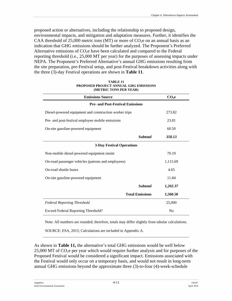
Chapter 4: Alternatives Impacts Assessment
AngelFest 4-11 150107
Draft Environmental Assessment April 2016
proposed action or alternatives, including the relationship to proposed design, environmental impacts, and mitigation and adaptation measures. Further, it identifies the CAA threshold of 25,000 metric tons (MT) or more of CO2e on an annual basis as an indication that GHG emissions should be further analyzed. The Proponent’s Preferred Alternative emissions of CO2e have been calculated and compared to the Federal reporting threshold (i.e., 25,000 MT per year) for the purposes of assessing impacts under NEPA. The Proponent’s Preferred Alternative’s annual GHG emissions resulting from the site preparation, pre-Festival setup, and post-Festival breakdown activities along with the three (3)-day Festival operations are shown in Table 11.
TABLE 11 PROPOSED PROJECT ANNUAL GHG EMISSIONS
(METRIC TONS PER YEAR)
Emissions Source CO2e
Pre- and Post-Festival Emissions
Diesel-powered equipment and construction worker trips 273.82
Pre- and post-festival employee mobile emissions 23.81
On-site gasoline-powered equipment 60.50
Subtotal 358.13
3-Day Festival Operations
Non-mobile diesel-powered equipment onsite 70.19
On-road passenger vehicles (patrons and employees) 1,115.69
On-road shuttle buses 4.65
On-site gasoline-powered equipment 11.84
Subtotal 1,202.37
Total Emissions 1,560.50
Federal Reporting Threshold 25,000
Exceed Federal Reporting Threshold? No
Note: All numbers are rounded; therefore, totals may differ slightly from tabular calculations. SOURCE: ESA, 2015; Calculations are included in Appendix A.
As shown in Table 11, the alternative’s total GHG emissions would be well below 25,000 MT of CO2e per year which would require further analysis and for purposes of the Proposed Festival would be considered a significant impact. Emissions associated with the Festival would only occur on a temporary basis, and would not result in long-term annual GHG emissions beyond the approximate three (3)-to-four (4)-week-schedule

Chapter 4: Chapter 4: Alternatives Impacts Assessment
AngelFest 4-12 150107
Draft Environmental Assessment April 2016
required for the Festival’s setup, operation, and breakdown activities. No permanent land uses would be introduced at the Proposed Project Site that would generate GHG emissions on a permanent basis. Overall, the GHG emissions generated by the Proponent’s Preferred Alternative’s would not have a significant impact associated with GHG emissions or with climate change. Implementation of Environmental Commitments AQ-1 through AQ-5 will further minimize any potential impacts regarding air quality. 4.3.3 Alternative 2 Under Alternative 2, the parking plan would be redesigned to include the more parking within the Basin as opposed to off-site parking locations. This, in turn, would reduce the number of satellite shuttles to the Proposed Project Site. Consequently, the slight reduction in the number of shuttles operating during the festival would result in corresponding reductions of pollutant emissions and GHG emissions from the shuttles. As such, the environmental effects associated with pollutant and GHG emissions would be similar but slightly less in magnitude under this alternative compared to the Proponent’s Preferred Alternative. 4.3.4 No Action Alternative The No Action Alternative would leave the Proposed Project Site in its present conditions, and no changes to the existing environment would occur. Thus, no additional sources of pollutant or GHG emissions other than those that are currently being generated by passenger vehicles associated with park visitors at the Proposed Project Site would occur. 4.3.5 Environmental Commitments The following environmental commitments would be in place to further minimize impacts to air quality. AQ-1 A Fugitive Dust Emission Control Plan would be developed and implemented.
Measures to be incorporated into the plan would include: All unpaved areas will be watered down prior to opening for use each day
to minimize fugitive dust (consistent with ER PLR-1). Install wheel washers/cleaners or wash the wheels of trucks and other
heavy equipment where vehicles exit the site or unpaved access roads. Increase the frequency of watering, or implement other additional fugitive
dust mitigation measures, of all disturbed fugitive dust emission sources when wind speeds (as instantaneous wind gusts) exceed 20 miles per hour.
AQ-2 All refuse generated at the Proposed Project Site will be stored in covered containers and removed at regular intervals in compliance with solid waste
Chapter 4: Alternatives Impacts Assessment
AngelFest 4-13 150107
Draft Environmental Assessment April 2016
regulations to ensure no objectionable odors affecting a substantial number of people would result from the Festival.
AQ-3 All on-road construction vehicles will meet all applicable California on-road emission standards and will be licensed in the State of California. This does not apply to construction worker personal vehicles.
AQ-4 All off-road construction diesel engines not registered under California Air Resources Board’s Statewide Portable Equipment Registration Program, which have a rating of 50 horsepower or more, shall meet, at a minimum, the Tier 3 California Emission Standards for Off-road Compression-Ignition Engines as specified in California Code of Regulations, Title 13, Section 2423(b)(1). If a Tier 3 or Tier 3-equivalent engine is not available for a particular item of equipment, Tier 2 compliant engines shall be allowed on a case by case basis.
AQ-5 Idling of heavy-duty diesel trucks during loading and unloading shall be limited to five minutes; auxiliary power units will be used whenever possible. State law requires drivers of diesel fueled commercial vehicles weighing more than 10,000 pounds:
Shall not idle a diesel-fueled auxiliary power system (APS) for more than 5 minutes to power a heater, air conditioner, or any ancillary equipment on the vehicle if you have a sleeper berth and you are within 100 feet of a restricted area (homes and schools).
Construction worker trips should be minimized by requiring carpooling and by providing for lunch onsite.
Water or use environmentally safe chemical stabilization to treat the earthen fill storage piles to create stabilized surfaces that will minimize wind erosion emissions.
Limit vehicle speeds on the Proposed Action Site unpaved roads to 10 mph.
4.4 Noise 4.4.1 Thresholds of Significance The Proposed Action may result in significant impacts on noise quality if:
Projected noise levels would not comply with the relevant Federal, state, and/or local standards or regulations; and/or
There would be a substantial permanent increase in noise levels above the existing ambient condition at either residential or sensitive wildlife receptors as a result of the activities.
4.4.2 Proponent’s Preferred Alternative 4.4.2.1 On-Site Setup and Breakdown Noise
Chapter 4: Chapter 4: Alternatives Impacts Assessment
AngelFest 4-14 150107
Draft Environmental Assessment April 2016
The Festival includes a 16-day setup period prior to the Festival and an 8-day breakdown period after the Festival at the Proposed Project Site. For the purposes of this Festival, setup and breakdown equates to construction activities. While pre-Festival site preparation activities at the Van Nuys Model Airplane Field, corn maze east of Woodley Avenue, the area north of the cricket fields, and the northwest corner of the Sepulveda Basin would also occur, these activities would be relatively minor when compared to the Festival setup and breakdown activities as they would generally involve the continuation of existing vegetation management activities (mowing and raking) along with light mechanized grading in certain areas where leveling is needed, currently expected to be north of the cricket fields and behind the archery range. The pre-Festival site preparation activities are anticipated to require small power tools and small-scale construction equipment.
The majority of the equipment that would generally be used for the setup and breakdown activities would include forklifts, boom lifts, platform lifts, cranes, crawler loaders, and skid-steer loaders. Noise impacts from these activities that occur within the Proposed Project Site would be a function of the noise generated by construction equipment, the location of the equipment, the timing and duration of the noise-generating construction activities, and the distance to noise receptors located offsite. The maximum noise levels generated by the individual pieces of construction equipment that would be used for the Festival’s construction activities at a distance of 50 feet are shown in Table 12. These noise levels at a distance of 50 feet for the construction equipment are based on the Federal Highway Administration’s (FHWA) Roadway Construction Noise Model (RCNM) User’s Guide (FHWA, 2006), which is a technical report containing actual measured noise data for construction equipment. While not all of the specific construction equipment anticipated to be used at the Proposed Project Site is available for selection in the RCNM model, other construction equipment that are similar in type and size are used as surrogates in this analysis. As shown in Table 12, the construction equipment that would be used at the Proposed Project Site could produce maximum noise levels of 74 A-weighted decibels (dBA) to 81 dBA at a reference distance of 50 feet from the noise source. These maximum noise levels would occur when the equipment is operating under full power conditions. However, because construction equipment used on construction sites often operates at less than full power, an acoustical usage factor is applied. The acoustical usage factor is a percentage of time that a particular piece of equipment is anticipated to be in full power operation during a typical construction day. These acoustical usage factors are estimates and would vary based on the actual construction activities and duration.
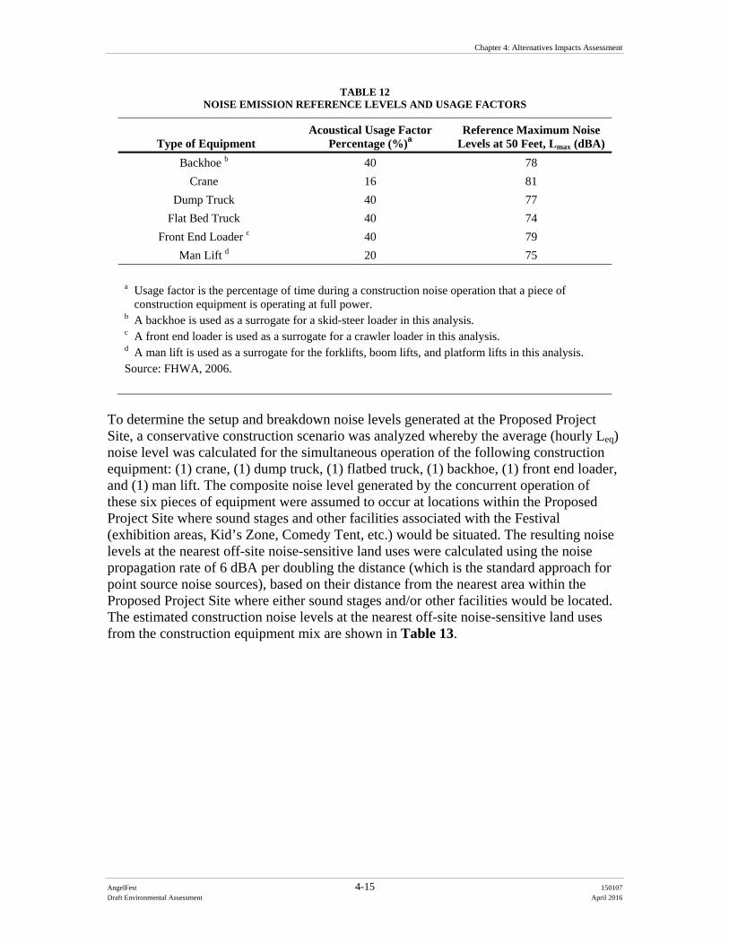
Chapter 4: Alternatives Impacts Assessment
AngelFest 4-15 150107
Draft Environmental Assessment April 2016
TABLE 12 NOISE EMISSION REFERENCE LEVELS AND USAGE FACTORS
Type of Equipment Acoustical Usage Factor
Percentage (%)a Reference Maximum Noise
Levels at 50 Feet, Lmax (dBA)
Backhoe b 40 78
Crane 16 81
Dump Truck 40 77
Flat Bed Truck 40 74
Front End Loader c 40 79
Man Lift d 20 75
a Usage factor is the percentage of time during a construction noise operation that a piece of construction equipment is operating at full power.
b A backhoe is used as a surrogate for a skid-steer loader in this analysis. c A front end loader is used as a surrogate for a crawler loader in this analysis. d A man lift is used as a surrogate for the forklifts, boom lifts, and platform lifts in this analysis. Source: FHWA, 2006.
To determine the setup and breakdown noise levels generated at the Proposed Project Site, a conservative construction scenario was analyzed whereby the average (hourly Leq) noise level was calculated for the simultaneous operation of the following construction equipment: (1) crane, (1) dump truck, (1) flatbed truck, (1) backhoe, (1) front end loader, and (1) man lift. The composite noise level generated by the concurrent operation of these six pieces of equipment were assumed to occur at locations within the Proposed Project Site where sound stages and other facilities associated with the Festival (exhibition areas, Kid’s Zone, Comedy Tent, etc.) would be situated. The resulting noise levels at the nearest off-site noise-sensitive land uses were calculated using the noise propagation rate of 6 dBA per doubling the distance (which is the standard approach for point source noise sources), based on their distance from the nearest area within the Proposed Project Site where either sound stages and/or other facilities would be located. The estimated construction noise levels at the nearest off-site noise-sensitive land uses from the construction equipment mix are shown in Table 13.
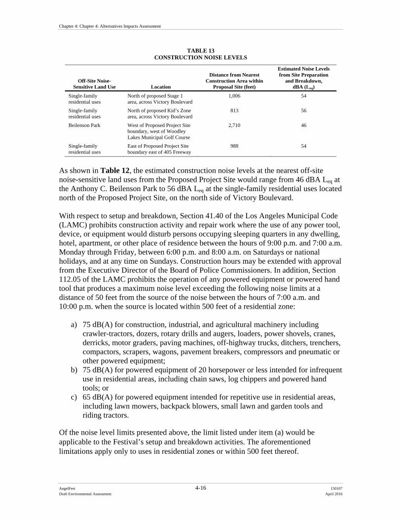
Chapter 4: Chapter 4: Alternatives Impacts Assessment
AngelFest 4-16 150107
Draft Environmental Assessment April 2016
TABLE 13 CONSTRUCTION NOISE LEVELS
Off-Site Noise-Sensitive Land Use Location
Distance from Nearest Construction Area within
Proposal Site (feet)
Estimated Noise Levels from Site Preparation
and Breakdown, dBA (Leq)
Single-family residential uses
North of proposed Stage 1 area, across Victory Boulevard
1,006 54
Single-family residential uses
North of proposed Kid’s Zone area, across Victory Boulevard
813 56
Beilenson Park West of Proposed Project Site boundary, west of Woodley Lakes Municipal Golf Course
2,710 46
Single-family residential uses
East of Proposed Project Site boundary east of 405 Freeway
988 54
As shown in Table 12, the estimated construction noise levels at the nearest off-site noise-sensitive land uses from the Proposed Project Site would range from 46 dBA Leq at the Anthony C. Beilenson Park to 56 dBA Leq at the single-family residential uses located north of the Proposed Project Site, on the north side of Victory Boulevard. With respect to setup and breakdown, Section 41.40 of the Los Angeles Municipal Code (LAMC) prohibits construction activity and repair work where the use of any power tool, device, or equipment would disturb persons occupying sleeping quarters in any dwelling, hotel, apartment, or other place of residence between the hours of 9:00 p.m. and 7:00 a.m. Monday through Friday, between 6:00 p.m. and 8:00 a.m. on Saturdays or national holidays, and at any time on Sundays. Construction hours may be extended with approval from the Executive Director of the Board of Police Commissioners. In addition, Section 112.05 of the LAMC prohibits the operation of any powered equipment or powered hand tool that produces a maximum noise level exceeding the following noise limits at a distance of 50 feet from the source of the noise between the hours of 7:00 a.m. and 10:00 p.m. when the source is located within 500 feet of a residential zone:
a) 75 dB(A) for construction, industrial, and agricultural machinery including crawler-tractors, dozers, rotary drills and augers, loaders, power shovels, cranes, derricks, motor graders, paving machines, off-highway trucks, ditchers, trenchers, compactors, scrapers, wagons, pavement breakers, compressors and pneumatic or other powered equipment;
b) 75 dB(A) for powered equipment of 20 horsepower or less intended for infrequent use in residential areas, including chain saws, log chippers and powered hand tools; or
c) 65 dB(A) for powered equipment intended for repetitive use in residential areas, including lawn mowers, backpack blowers, small lawn and garden tools and riding tractors.
Of the noise level limits presented above, the limit listed under item (a) would be applicable to the Festival’s setup and breakdown activities. The aforementioned limitations apply only to uses in residential zones or within 500 feet thereof.
Chapter 4: Alternatives Impacts Assessment
AngelFest 4-17 150107
Draft Environmental Assessment April 2016
As shown in Table 12, the areas within the Proposed Project Site where construction equipment would be used for the setup and breakdown activities would be located beyond 500 feet of the nearest off-site residential uses. As such, the operation of construction equipment within the Proposed Project Site would not violate the noise limitations of Section 112.05 of the LAMC. As no noise standards or regulations regarding breakdown and setup activities would be exceeded or violated, the Proponent’s Preferred Alternative would not have significant effects associated with its Festival setup and breakdown activities. Further, there would not be a substantial permanent increase in noise levels above the existing ambient condition at either residential or sensitive wildlife receptors as a result of the Festival activities. Environmental Commitments N-1 through N-6, listed in Section 4.4.5 and Appendix D, will further minimize these insignificant impacts. 4.4.2.2 On-Site Festival Operations During operation of the three (3) -day festival, noise levels generated at the Proposed Project Site would primarily be dominated by the outdoor amplified sound systems. Additionally, crowd noise would also be perceptible at the surrounding uses to the Proposed Project Site throughout the day, although these noise levels would occur sporadically and would be the loudest at the end of a musical performance. Throughout the course of an event day, the most notable and constant noise that would be experienced by the surrounding uses to the Proposed Project Site would be those generated from the outdoor sound stages. In addition, use of pyrotechnics and fireworks could generate additional noise, but would not result in a significant impact because those activities would last between 10-15 minutes and would not be constant throughout an event day. The Proposed Project Site is located in the City of Los Angeles and operates under the restrictions of the LAMC on the local level. The City’s comprehensive Noise Ordinance, found in Chapter XI of the LAMC, sets forth sound measurement procedure and criteria, minimum ambient noise levels for different land use zoning classifications, sound emission levels for specific uses, hours of operation for certain uses, standards for determining when noise is deemed to be a disturbance, and legal remedies for violations. Based on a review of the noise provisions in the City’s Noise Ordinance for special noise sources, Section 115.02 of the LAMC, which regulates noise levels from sound amplifying equipment, stipulates that no sound amplifying equipment should be installed, operated, or used for commercial purposes at any time in all residential zones or within 500 feet of a residential zone. Additionally, in all other non-residential zones the operation or use of sound amplifying equipment for commercial purposes is prohibited between the hours of 9:00 p.m. and 8:00 a.m. of the following day. Furthermore, Section 115.02 prohibits sound from amplified sound equipment to be audible at a distance in excess of 200 feet from the sound equipment. However, the noise regulations of Section 115.02 do not apply to a Special Event that is permitted under Section 41.20.1 of the LAMC, which is defined as:
Chapter 4: Chapter 4: Alternatives Impacts Assessment
AngelFest 4-18 150107
Draft Environmental Assessment April 2016
“an event, or series of related events, of cultural, civic, economic, social, recreational or educational nature, including Athletic Events, sponsored by an individual or individuals, a non-profit organization or community group, charitable organization or for-profit organization or group, that is: (1) held wholly or partially on property owned or maintained by the City; or (2) held on any other property, and that requires for its successful execution, the partial or complete closure of streets or sidewalks or the provision and coordination of municipal services to a degree over and above the level that the City normally provides. Special Events also include any other organized activity that involves the use of, or has a direct or indirect impact on, public property or facilities or that can reasonably be foreseen to have such an impact on, or to require a higher level of, public safety services or other municipal services, including advance planning services, than that normally provided by the City.”
Although operation of the proposed three (3) -day Festival would result in increased noise levels at the Proposed Project Site and its immediate surrounding area, this temporary Special Event would be authorized by the City and would not be subject to the noise regulations stipulated in Section 115.02 of the LAMC. Therefore, projected noise levels would comply with the relevant standards and regulations. For the purposes of determining whether there would be a significant impact from an increase in noise levels above the ambient condition, the noise levels that would be generated from the amplified sound systems at the Proposed Project Site have been analyzed and evaluated against the existing noise environment at the nearest off-site noise sensitive uses. While a definitive stage timing schedule for the Festival has not been finalized at this time, it is anticipated that Stage 1 and Stage 2 would not be operating simultaneously during the Festival. It is also anticipated that Stage 3 and Stage 4 would not be operating simultaneously during the Festival hours. However, Stage 1 and Stage 3 are anticipated to operate in a simultaneous manner from time to time each Festival day, generally during daylight hours. Stage 1 and Stage 4 are expected to operate in a simultaneous manner from 12:00 p.m. to -11:00 p.m. (9:45 p.m. on Sunday). Finally, Stage 5 is expected to operate simultaneously with Stages 1, 2, 3, or 4. Given these conditions, the noise levels generated from the Festival’s outdoor stage sound systems were evaluated for the following scenarios:
1. Simultaneous operation of Stages 1, 3, and 5; 2. Simultaneous operation of Stages 1, 4, and 5; 3. Simultaneous operation of Stages 2, 3, and 5; and 4. Simultaneous operation of Stages 2, 4, and 5.
Chapter 4: Alternatives Impacts Assessment
AngelFest 4-19 150107
Draft Environmental Assessment April 2016
The resulting noise levels at the nearest sensitive receptors located offsite from the simultaneous operation of outdoor stages during the festival are shown in Table 14 (noise-sensitive receptors, some of which are residential sites, are R1-R27 and wildlife receivers are W1 through W10). The off-site receptor locations and wildlife receivers referred to in Table 13 are shown in Figure 10. Based on the results shown in Table 14, the highest noise levels experienced by the surrounding off-site noise-sensitive receptors (R1 through R27) from the Festival’s outdoor amplified sound systems (under the four scenarios identified above) would occur to the north and to the west of the Proposed Project Site. Receptor Locations that would experience highest noise levels include R2 through R5, R7, and R22 through R27. The noise levels to the west (Receptor Locations R2-R5, R7) would range from 58 to 67 dBA Leq, while the noise levels to the north (Receptor Locations R23-R27) would range from 59 to 65 dBA Leq during the various scenarios where multiple sound stages would be operating concurrently. To determine the potential increase in noise levels that would be experienced at these receiver locations during the festival, long-term (24-hour) noise measurements were taken in the vicinity of R5 and R25 on November 4, 2015. R5 and R25 was selected because it was determined that the collected ambient noise levels would represent other nearby modeled receivers. These noise measurements were conducted using Metrosonics Model db-3080 sound level meters that were calibrated prior to use and operated according to the manufacturer’s written specifications. The location of the long-term noise measurements are shown in Figure 9, and the hourly noise levels that were recorded at the two locations are provided in Table 4. Based on the existing hourly noise levels shown in Table 4, it is determined that the existing hourly ambient noise levels near the residential uses located at Receptor Location R25 would be greater than the noise levels generated by the Festival’s amplified sound systems during all of the active Festival hours (i.e., 12:00 p.m. to 11:00 p.m.) when amplified sound systems would be in operation. Even outside Festival operation hours, the lowest ambient level recorded for R25 was 65 dBA. This is the same as the highest noise level anticipated under any of the four stage combination scenarios during Festival operation. Therefore, no increase in noise level is expected from the Festival at R25 or other nearby noise-sensitive receptors.
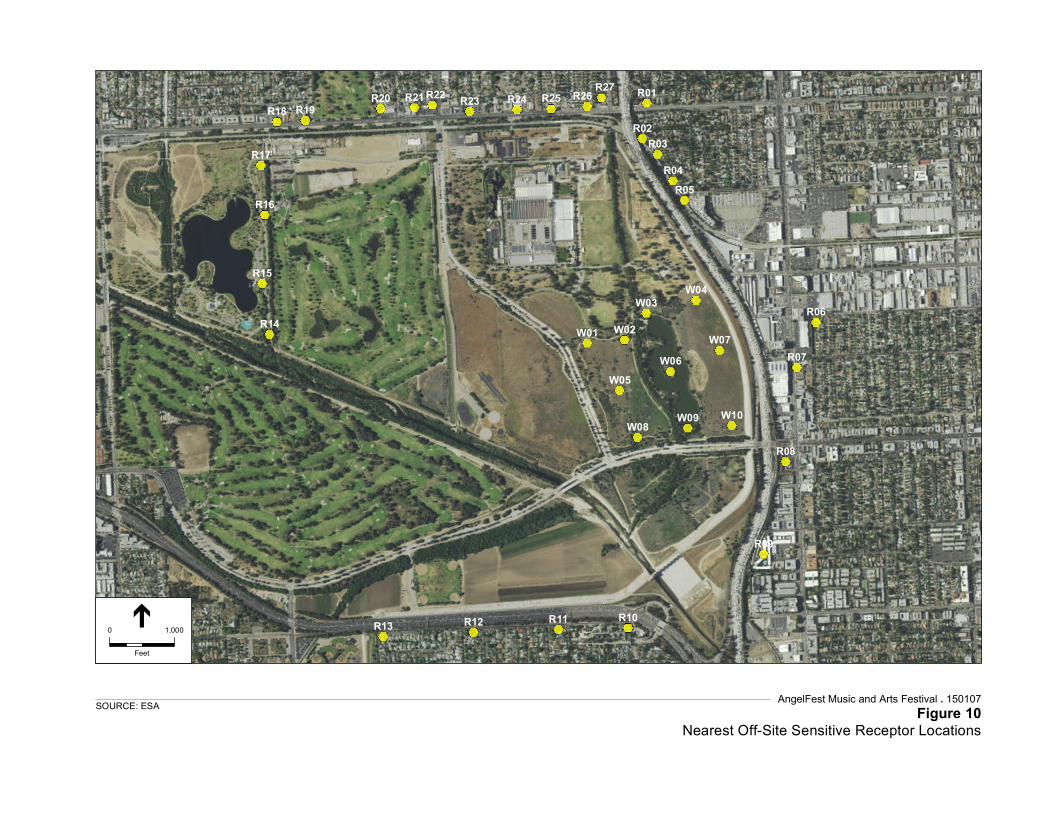
Service Layer Credits: Source: Esri,DigitalGlobe, GeoEye, Earthstar Geographics,CNES/Airbus DS, USDA, USGS, AEX,Getmapping, Aerogrid, IGN, IGP, swisstopo,and the GIS User Community
R01
R02R03
R05R04
R06
R07
R08
R09
R13 R12 R11 R10
R14
R15
R16
R17
R18 R19R20 R21 R22 R23 R24 R25 R26 R27
W01 W02
W03W04
W05W06
W07
W08 W09 W10
AngelFest Music and Arts Festival . 150107Figure 10
Nearest Off-Site Sensitive Receptor LocationsSOURCE: ESA
0 1,000
Feet
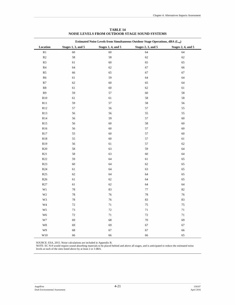
Chapter 4: Alternatives Impacts Assessment
AngelFest 4-21 150107
Draft Environmental Assessment April 2016
TABLE 14 NOISE LEVELS FROM OUTDOOR STAGE SOUND SYSTEMS
Location
Estimated Noise Levels from Simultaneous Outdoor Stage Operations, dBA (Leq)
Stages 1, 3, and 5 Stages 1, 4, and 5 Stages 2, 3, and 5 Stages 2, 4, and 5
R1 60 60 64 64
R2 58 58 62 62
R3 61 60 65 65
R4 64 62 67 66
R5 66 65 67 67
R6 61 59 64 64
R7 62 60 65 64
R8 61 60 62 61
R9 59 57 60 58
R10 61 61 58 58
R11 59 57 58 56
R12 57 56 57 55
R13 56 56 55 55
R14 56 59 57 60
R15 56 60 58 60
R16 56 60 57 60
R17 55 60 57 60
R18 55 60 57 61
R19 56 61 57 62
R20 58 63 59 64
R21 58 63 60 64
R22 59 64 61 65
R23 60 64 62 65
R24 61 64 63 65
R25 62 64 64 65
R26 61 62 64 65
R27 61 62 64 64
W1 78 83 77 82
W2 78 76 78 76
W3 78 76 83 83
W4 72 71 75 75
W5 73 72 71 71
W6 72 71 72 71
W7 69 68 70 69
W8 69 69 67 67
W9 68 67 67 66
W10 66 66 66 65 SOURCE: ESA, 2015. Noise calculations are included in Appendix B. NOTE: EC N-8 would require sound absorbing materials to be placed behind and above all stages, and is anticipated to reduce the estimated noise levels at each of the sites listed above by at least 2 or 3 dBA.
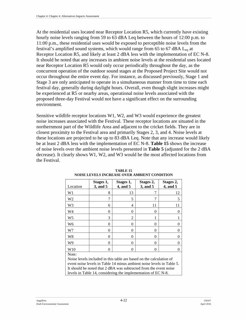
Chapter 4: Chapter 4: Alternatives Impacts Assessment
AngelFest 4-22 150107
Draft Environmental Assessment April 2016
At the residential uses located near Receptor Location R5, which currently have existing hourly noise levels ranging from 59 to 63 dBA Leq between the hours of 12:00 p.m. to 11:00 p.m., these residential uses would be exposed to perceptible noise levels from the festival’s amplified sound systems, which would range from 65 to 67 dBA Leq at Receptor Location R5, and likely at least 2 dBA less with the implementation of EC N-8. It should be noted that any increases in ambient noise levels at the residential uses located near Receptor Location R5 would only occur periodically throughout the day, as the concurrent operation of the outdoor sound stages at the Proposed Project Site would not occur throughout the entire event day. For instance, as discussed previously, Stage 1 and Stage 3 are only anticipated to operate in a simultaneous manner from time to time each festival day, generally during daylight hours. Overall, even though slight increases might be experienced at R5 or nearby areas, operational noise levels associated with the proposed three-day Festival would not have a significant effect on the surrounding environment. Sensitive wildlife receptor locations W1, W2, and W3 would experience the greatest noise increases associated with the Festival. These receptor locations are situated in the northernmost part of the Wildlife Area and adjacent to the cricket fields. They are in closest proximity to the Festival area and primarily Stages 2, 3, and 4. Noise levels at these locations are projected to be up to 83 dBA Leq. Note that any increase would likely be at least 2 dBA less with the implementation of EC N-8. Table 15 shows the increase of noise levels over the ambient noise levels presented in Table 5 (adjusted for the 2 dBA decrease). It clearly shows W1, W2, and W3 would be the most affected locations from the Festival.
TABLE 15 NOISE LEVELS INCREASE OVER AMBIENT CONDITION
Location Stages 1, 3, and 5
Stages 1, 4, and 5
Stages 2, 3, and 5
Stages 2, 4, and 5
W1 8 13 7 12
W2 7 5 7 5
W3 6 4 11 11
W4 0 0 0 0
W5 3 2 1 1
W6 0 0 0 0
W7 0 0 0 0
W8 0 0 0 0
W9 0 0 0 0
W10 0 0 0 0 Note: Noise levels included in this table are based on the calculation of event noise levels in Table 14 minus ambient noise levels in Table 5. It should be noted that 2 dBA was subtracted from the event noise levels in Table 14, considering the implementation of EC N-8.
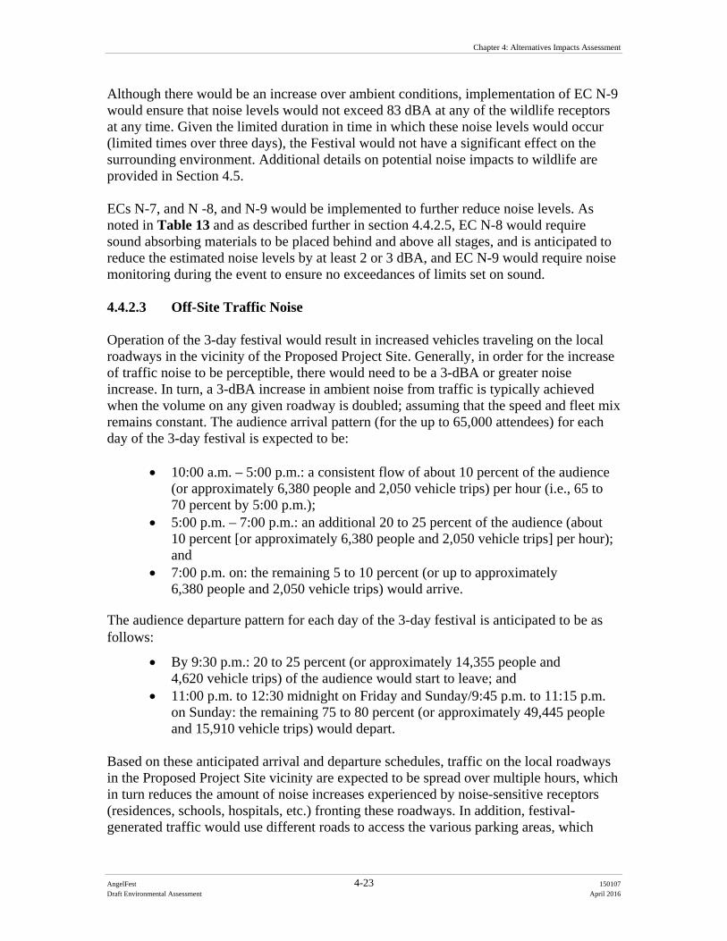
Chapter 4: Alternatives Impacts Assessment
AngelFest 4-23 150107
Draft Environmental Assessment April 2016
Although there would be an increase over ambient conditions, implementation of EC N-9 would ensure that noise levels would not exceed 83 dBA at any of the wildlife receptors at any time. Given the limited duration in time in which these noise levels would occur (limited times over three days), the Festival would not have a significant effect on the surrounding environment. Additional details on potential noise impacts to wildlife are provided in Section 4.5. ECs N-7, and N -8, and N-9 would be implemented to further reduce noise levels. As noted in Table 13 and as described further in section 4.4.2.5, EC N-8 would require sound absorbing materials to be placed behind and above all stages, and is anticipated to reduce the estimated noise levels by at least 2 or 3 dBA, and EC N-9 would require noise monitoring during the event to ensure no exceedances of limits set on sound. 4.4.2.3 Off-Site Traffic Noise Operation of the 3-day festival would result in increased vehicles traveling on the local roadways in the vicinity of the Proposed Project Site. Generally, in order for the increase of traffic noise to be perceptible, there would need to be a 3-dBA or greater noise increase. In turn, a 3-dBA increase in ambient noise from traffic is typically achieved when the volume on any given roadway is doubled; assuming that the speed and fleet mix remains constant. The audience arrival pattern (for the up to 65,000 attendees) for each day of the 3-day festival is expected to be:
10:00 a.m. – 5:00 p.m.: a consistent flow of about 10 percent of the audience (or approximately 6,380 people and 2,050 vehicle trips) per hour (i.e., 65 to 70 percent by 5:00 p.m.);
5:00 p.m. – 7:00 p.m.: an additional 20 to 25 percent of the audience (about 10 percent [or approximately 6,380 people and 2,050 vehicle trips] per hour); and
7:00 p.m. on: the remaining 5 to 10 percent (or up to approximately 6,380 people and 2,050 vehicle trips) would arrive.
The audience departure pattern for each day of the 3-day festival is anticipated to be as follows:
By 9:30 p.m.: 20 to 25 percent (or approximately 14,355 people and 4,620 vehicle trips) of the audience would start to leave; and
11:00 p.m. to 12:30 midnight on Friday and Sunday/9:45 p.m. to 11:15 p.m. on Sunday: the remaining 75 to 80 percent (or approximately 49,445 people and 15,910 vehicle trips) would depart.
Based on these anticipated arrival and departure schedules, traffic on the local roadways in the Proposed Project Site vicinity are expected to be spread over multiple hours, which in turn reduces the amount of noise increases experienced by noise-sensitive receptors (residences, schools, hospitals, etc.) fronting these roadways. In addition, festival-generated traffic would use different roads to access the various parking areas, which
Chapter 4: Chapter 4: Alternatives Impacts Assessment
AngelFest 4-24 150107
Draft Environmental Assessment April 2016
would reduce the amount of vehicular traffic on any individual roadway. It is expected that the majority of vehicles accessing the Proposed Project Site would travel along the major arterials such as Sepulveda Boulevard, Balboa Boulevard, Victory Boulevard, Sherman Way, Vanowen Street, and Burbank Boulevard. While recent 2011 data regarding the average daily traffic volumes on these roadways are available from the LADOT, no current hourly traffic data is readily available for these roadways. However, as a general rule of thumb, the peak hour traffic volumes typically represent 10 percent of the average daily traffic volumes in an urban environment. As it is estimated that approximately 2,050 vehicle trips per hour would occur during the arrival period on the event day, this amount of vehicle trips per hour would not result in the doubling of traffic volumes on any of these arterial roadways. Additionally, because the 2,050 vehicle trips per hour would be spread out on multiple roadways, none of the arterial roadways discussed above would experience the entire 2,050 vehicle trips. As such, the increased traffic resulting from the Festival during the arrival period would not result in a substantial increase in traffic noise levels and would not result in a significant effect on noise-sensitive uses located along the local roadways. During the departure period, however, it is estimated that up to 15,910 vehicle trips could occur between the hours of 11:00 p.m. and 12:30 a.m. on Friday and Saturday (between 9:45 p.m. and 11:15 p.m. on Sunday) While this amount of vehicle trips would likely result in more than doubling of traffic on the arterial roadways in the Proposed Project Site vicinity, traffic noise levels would not necessarily increase along these roadways because the amount of traffic would likely result in substantially reduced vehicle travel speeds. For instance, while the posted speed limit on Victory Boulevard is 45 miles per hour (mph), the vehicles traveling on this roadway during the departure period would only be traveling at 25 mph or lower due to the traffic congestion, which would result in substantially reduced traffic noise levels which would not result in a significant impact. Overall, as discussed previously, the Festival would be a permitted Special Event that would be authorized by the City. As part of the permitting process, a traffic and parking management plan, prepared in coordination with the Special Events section of the LADOT, would be required to ensure that significant effects on traffic (including transit and pedestrian) conditions (congestion and safety) would be minimized.2 The Special Events section and RAP would coordinate local signage, alerts, etc. As the festival is a Special Event that would only occur for a temporary period (24 days of setup and teardown and three (3) days of the Festival), any potential noise increase along roadways in the Proposed Project Site vicinity would only be temporary in nature and would not have a significant impact on the surrounding community or environment. To further minimize any potential impacts, Environmental Commitments N-1 through N-9 would be implemented.
2 A Preliminary Plan for Traffic and Parking at the Sepulveda Basin Recreational Area for the proposed AngelFest
Festival was prepared by PST Event Engineering, LLC, on September 29, 2015. A Final Plan would be submitted to the LADOT Special Events section in advance of the Festival.
Chapter 4: Alternatives Impacts Assessment
AngelFest 4-25 150107
Draft Environmental Assessment April 2016
4.4.3 Alternative 2 Under Alternative 2, Balboa Golf Course would be used for parking. Under this Alternative, the number of shuttle trips would be reduced because attendees could walk to the Proposal Site from the Balboa Golf Course. Implementation of the alternative would result in comparable impacts as the Proponent’s Preferred Alternative, and no noise standards or regulations regarding construction activities would be exceeded or violated. In addition, any increase in noise compared to ambient levels would not be significant because setup and breakdown would be temporary and would not result in permanent increases in ambient noise levels; therefore, Alternative 2 would not have significant effects associated with its Festival setup and breakdown activities. Additionally, because the three (3) -day Festival would be a permitted Special Event that would be authorized by the City, no noise standards or regulations would be violated by the Proposed Action. While noise levels from the Festival’s amplified sound systems may be perceptible at the existing residential uses located near Receptor Location R5, these increases in noise levels would only occur on a temporary basis and would not increase significantly as compared to ambient levels. As such, operational noise levels associated with the implementation of Alternative 2 would not have a significant effect on the surrounding environment. Consistent with the Proponent’s Preferred Alternative, Alternative 2 is a Special Event that would only occur for a three (3)-day period, any potential noise increase along roadways in the Proposed Project Site vicinity would only be temporary in nature and would not have a significant impact on the surrounding community or environment. 4.4.4 No Action Alternative The No Action Alternative would leave the Proposed Project Site in its present conditions, and no temporary changes to the existing noise environment would occur. General noise levels associated with passive and active recreation activities would continue to occur on the Proposed Project Site. 4.4.5 Environmental Commitments The following environmental commitments would be in place to further minimize any potential noise impacts:
N-1 All equipment used will be muffled and maintained in good operating condition. All internal combustion engine driven equipment will be fitted with well-maintained mufflers in accordance with manufacturer’s recommendations.
N-2 A toll-free telephone number shall be established for dealing with public concerns/ complaints about noise and other project-related issues.
N-3 As part of the Proposed Action’s advanced notification to all residences and property owners, a contact person name and phone number shall be provided. The contact person shall respond to questions or concerns related to noise and

Chapter 4: Chapter 4: Alternatives Impacts Assessment
AngelFest 4-26 150107
Draft Environmental Assessment April 2016
vibration within 24 hours. If warranted by inquiries or complaints, on-site noise measurements shall be taken to determine if noise or vibration levels are substantially greater than expected levels.
N-4 All equipment shall include noise reduction measures, as applicable. These measures shall include, but may not be limited to, properly operating and maintaining mufflers, correct placement of equipment engine covers, and ensuring that small loading equipment is equipped with rubber tires.
N-5 All machinery shall be equipped with the best available exhaust mufflers and “hush kits,” as applicable.
N-6 Noise producing signals, including horns, whistles, alarms, and bells shall be limited to safety warning purposes only.
N-7 All measures described in Section 2.3.1.4 of the draft EA will be implemented for the applicable sound systems.
N-8 The stage design will include sound absorbing materials at each stage to further minimize any noise. These materials would be placed on the stage roof, rear of stage, and areas behind the loudspeaker arrays. Estimated sound reduction in areas behind the stages would be between 2 and 3 dB. The following describes the sound absorbing materials: Stage design would include sound absorptive 2-inch thick weather
resistant panels with an emphasis on the stage roof, rear of stage and areas behind the loudspeaker arrays.
Material allows for sound to reach the absorptive core, and have a NRC rating of 0.85 or higher.
Sound Monitors would be located in sensitive areas to monitor sound levels from Stages 2, 3, and 4. The Sound Monitors would have both a sound level meter and a communication device that would be used to report to the production manager when sound levels exceed the goals.
N-9 During the two (2) weeks prior to the Festival setup beginning, ambient noise
levels will be recorded at four (4) designated locations, as designated by a Corps biologist, within the Wildlife Area at least three times a week to document pre-Festival conditions. One (1) recording each week will occur during a weekend day, and the other two (2) will occur during a weekday. Monitoring will occur hourly from 12:00 p.m. until 11:00 p.m. to coincide with the hours music would be played at the Festival.
During one (1) week of the setup period, noise levels will be recorded in the same manner as above to document setup noise conditions.
Throughout the three (3) Festival days, noise monitors will monitor sound levels in real time both at the Front of House and at up to three (3) strategic locations within the communities adjacent to the Festival site and at the four (4) locations within the Wildlife Area previously identified by the Corps biologist. The monitoring within the Wildlife Area will be conducted at least hourly from when the music starts until it ends (11:00 p.m. on Friday and Saturday, 9:45 p.m. on Sunday). This real-time noise monitoring will create logs and records to document actual sound levels during the course of the
Chapter 4: Alternatives Impacts Assessment
AngelFest 4-27 150107
Draft Environmental Assessment April 2016
Festival, and will be consulted in the event of complaints. The sound monitors will have both a sound level meter and a communication device that can be used to report back to the production manager when sound levels exceed sited goals. The monitoring results will also be used to inform the Corps, RAP, and Festival Proponent, and if noise reaches levels exceed wildlife or community standards, adjustments in volume will be made to keep the noise within those standards. The wildlife standard is 83 dBA and the community standard is 67 dBA.
4.5 Biological Resources 4.5.1 Thresholds of Significance A significant impact could occur to biological resources if the Proposed Action would result in:
Impacts which would result in the loss or harm of a federally-listed species, either directly or through habitat modifications that would substantially diminish population numbers, or the distribution of a habitat type or its functions and values within the region
Substantial adverse effect on any riparian habitat or other sensitive natural community identified in local or regional plans, policies, and regulations or by the USFWS; Substantial adverse effect on Federally protected wetlands as defined by Section 404 of the CWA (including, but not limited to, marsh, vernal pool, and coastal wetlands) through direct removal, filling, hydrological interruption, or other means;
Substantial interference with the movement of any native resident or migratory wildlife species or with established native resident or migratory wildlife corridors, or impeded use of native wildlife breeding sites;
Substantial increase in the ambient noise levels for adjoining areas that interfere with breeding behavior and/or movement of foraging of resident species, specifically birds of prey
Substantial loss of species diversity in natural vegetation or wildlife habitat; Substantial loss of habitat that is regionally unique or designated as sensitive; Substantial disturbance or degradation of existing native and/or sensitive
vegetation. 4.5.2 Proponent’s Preferred Alternative 4.5.2.1 Overview The Proposed Project Site is highly developed in most places, and the use of Woodley Park I, II, and III, the cricket fields, archery range, and the parking areas during the Festival would be similar to the current and past uses. Certain areas of the Proposed Project Site are not highly developed: Haskell Creek (which would be fenced and not
Chapter 4: Chapter 4: Alternatives Impacts Assessment
AngelFest 4-28 150107
Draft Environmental Assessment April 2016
available for use by the public during the Festival, per EC WR-4) and the northwestern section of the Wildlife Area where backstage operation would occur along existing walking paths. Although limited trimming or mowing would occur, no direct removal of native habitat would occur during the setup or teardown of the Festival, which reduces the potential for impacts to biological resources. This alternative would include mowing, compaction of soils and grading, debris removal, and impacts to grass from vehicles and attendees of the Festival. It would also include installation of temporary fences along Haskell and Woodley Creeks to prevent Festival goers from impacting the habitat within these creeks, as required by EC WR-4. The alternative would also amplify noise and may include the use of fireworks, which could contribute to the Festivals’ noise impacts on wildlife. Any impacts that may occur would be temporary (predominantly over three days), and no common or special-status species are expected to be killed or permanently displaced from the Proponent’s Preferred Alternative. These impacts would be lessened by the implementation of ECs N-7, N-8, and N-9 for noise impacts, as well as the biological resources Environmental Commitments listed in Section 4.5.2.5. In particular, implementation of EC N-8 (installation of sound absorbing materials at each stage) is expected to reduce all noise by at least 2 dBA compared to the levels presented in Table 12. To further minimize any potential impacts, immediately following the Festival and during breakdown activities, all areas of the Proposed Project Site would be returned to pre-event conditions or better. This includes planting turf grass where needed, such as the cricket fields or general Woodley Park areas, replacement of damaged trees and shrubs, cleaning and removal of all waste, and any other cleaning and/or repairs that may be necessary (EC BIO-6). Areas including but not limited to the cricket fields, golf courses, ball fields, model airplane field, Haskell Creek, fencing, asphalt parking areas, dirt pathways, and grassy areas would be restored to a condition superior to their pre-production, pre-event status. Specific impacts to biological resources are discussed below. 4.5.2.2 Birds and Bats Native birds protected in accordance with the federal Migratory Bird Treaty Act of 1918 and Fish and Game Code (Sections 3503, 3503.5, 3511, and 3513) are expected to carry out their life cycle requisites such as nesting and foraging in the various habitat types and structures present within the Basin including existing disturbed habitat. The typical bird nesting season is February through September depending on the weather, and the Festival activities are scheduled in October to reduce potential impacts to nesting birds. While set up activities would begin at the end of the nesting season (mid-late September), activities during this period would be minimal, including employee trips and general increased activity consistent with the level of activity in the recreational area, and would not involve disturbance of nesting habitat. Most birds (including raptors) have completed their nesting cycle by September and the potential for a bird to nest this late in the season is low. Moreover, any bird that nests within close proximity (i.e., within 500 feet) to the
Chapter 4: Alternatives Impacts Assessment
AngelFest 4-29 150107
Draft Environmental Assessment April 2016
Festival site is expected to be somewhat adapted to urban environs and associated noises due to the existing ambient noises and human presence that already occurs in the immediate area. Therefore, a bird that may be nesting in proximity to the setup activities is not expected to abandon its nest, nor would the chicks be expected to jump out of the nest due to the additional noises and human presence associated with the initial Festival setup. With the use of the advanced sound system described in detail in Section 2.3.1.4 and required pursuant to EC N-7, noise within the Wildlife Area is anticipated to range from 65 to 83 dB (see Table 12), which would be roughly the equivalent to a food blender or garbage disposal at 3 feet distance. As noted above, with implementation of EC N-8, the noise level is expected to decrease by at least 2 dBA below those levels. Still, at certain times in certain locations within the Wildlife Area, the noise volume would exceed estimated ambient noise levels, potentially at levels up to a 13-dBA increase (see Table 15). In addition, the noise anticipated from the Festival differs from ambient noise like traffic noise, which resident birds are more accustomed to, because it would be a higher volume, would include sudden outbursts like fireworks, and would partially occur during nighttime hours, when traffic is typically slower but when some birds are more sensitive. Resident species are relatively adjusted to the local ambient conditions that include constant noise from two major highways, and periodic concerts and sporting events (e.g., cricket matches) that have increased levels of pedestrian activity in proximity to the wildlife area. As discussed further below, it is anticipated that due to noise and light impacts, some species would move away from the Festival site, such as by moving to the south portion of the lake in the Wildlife Area or to the Los Angeles River, or to the part of the Wildlife Area south of Burbank Boulevard. It is also anticipated that some individual animals could flee the Basin, either temporarily or, though unlikely, permanently, due to the noise and lights. In order to minimize any potential effects to wildlife from noise and lights, a number of environmental commitments would be required, as described at the end of this section and as noted in the noise section. Overall, the impacts to bird and bats, and all species, from noise and light sources are anticipated to be less than significant. For example, there is a viable population of nesting birds and breeding least Bell’s vireo within the Santa Clara River located in close proximity (approximately 1,000 feet) to the Six Flags Magic Mountain theme park where fireworks shows have occurred during the breeding season. In particular, this least Bell’s vireo population been monitored for several years and there is no literature to support that the birds have been affected by the theme park’s firework shows. Moreover, few, if any, birds are expected to be nesting in October when the Festival would occur and therefore no significant impacts from the fireworks show are anticipated to nesting birds. There would likely be impacts to resident and migratory birds foraging and resting/roosting in cover habitat. The Sepulveda Basin Wildlife Area has become a refugia for a wide array of songbirds, raptors, and waterbirds amongst the surrounding urban setting. These various taxa along with the mega-fauna (e.g., coyotes, bobcat) have not had to deal with acute loud noise or bright lighting over a three (3) day period, and more importantly including the night hours. The loud music and night lighting would range within 350 feet to 700 feet of the nearest water body used by
Chapter 4: Chapter 4: Alternatives Impacts Assessment
AngelFest 4-30 150107
Draft Environmental Assessment April 2016
wildlife for foraging and roosting habitat. As noted above, if birds and other more sensitive or illusive animals are present, they may temporarily relocate to the wildlife habitat farther south into the Wildlife Area and into the Corps Basin operation area south of Burbank Boulevard, or into the Los Angeles River. This could temporarily put extra pressure on bird populations, in particular the predator-prey process. Some animals may also temporarily or, though unlikely, permanently flee the basin. However, this disturbance is not expected to permanently threaten the existence of a population of birds, bats, or terrestrial wildlife, nor is any mortality of such animals expected to result from the temporary noises and lighting associated with the Festival. Laboratory studies have shown that gleaning bats, which locate prey by the sounds they make (i.e., echolocation), avoid hunting in noisy areas, which reduces the amount of once-habitable areas available to these species. For example, one gleaning bat species are less likely to cross roads than other bat species that forage in open areas, suggesting the noise of the traffic could fragment their hunting grounds. In terms of light, most bat species will not emerge from their roosts or feed in light levels above 1 Lux (1 Lux is natural full moon on a clear night). Light pollution can displace bats both temporarily and permanently. If this happens, bats do not have the same capacity to re-colonize because they only produce one pup per year, and only if the weather conditions allow. Research indicates that vision is very important to bats and observations of bat use of vision are well documented (Fure, 2006). For example, early emerging bats do not usually echolocate when leaving their roost; they use their vision. Bat vision works best in dim light. This vision can be interrupted by greater luminance, thus causing disruption in natural patterns of movement and foraging. This light sensitivity varies between species, but generally tolerance of red visual light is greater than white light (Fure, 2006). There are no potential bat maternity roosts or day roost sites located in the vicinity of the Proposed Project Site; therefore, the Festival activities (including setup and breakdown) would not impact any bat roosting colonies. Foraging bats may be temporarily displaced during the three (3)-day Festival, and a reduction of bat foraging may occur during the setup of the Festival in areas where nighttime lighting may be used. However, because the Proposed Project Site is located in an area where there are existing ambient noises and nightly illumination from the freeway corridors and city lights (as well other recreational uses of the property and general disturbance within the larger urban setting), and because the Festival would occur over a three (3)-day period, its effects on foraging bats would not be significant and the temporary noise and nighttime lighting impacts associate with the Festival are not expected to cause mortality of individuals or result in a local bat population to drop below self-sustaining levels. Overall, with implementation of ECs N-7, N-8, and N-9 as well as ECs BIO-1 through BIO-5, there is expected to be no significant impact to birds or bats. Although there would be an increase in noise from the alternative compared to ambient conditions, this increase would be temporary and would not be substantial enough such that it would interfere with breeding behavior and/or movement of foraging or resident species, such as birds of prey.
Chapter 4: Alternatives Impacts Assessment
AngelFest 4-31 150107
Draft Environmental Assessment April 2016
4.5.2.3 Special-Status Wildlife 4.5.2.3.1 Least Bell’s Vireo While set up activities would begin near the end of the nesting season (late September), least Bell’s vireo would have commenced migration and would not be present in their breeding sites. The activities associated with the Proposed Project Site would not drastically change the use of the area. Any vegetation disturbance would be restored prior to the species returning. There would be no significant impact related to the species. Due to the potential for minor impacts to least Bell’s vireo habitat along Haskell Creek, the Corps has determined the Proponent’s Preferred Alternative may effect, but is not likely to adversely affect, least Bell’s vireo. The Corps is informally consulting with the USFWS to seek concurrence with this determination. 4.5.2.3.2 Raptors Cooper’s hawk, a California Watchlist species, and other resident hawks and owls in the Basin (red-tailed hawk, red-shouldered hawk, barn owl, great-horned owl, and migrant raptors) are known to occur within urbanized habitat similar to that found on the Proposed Project Site. Because the Festival would occur outside of the bird nesting season (early-spring to mid-summer), no impacts would occur to breeding pairs or their nests. These species are known to forage within urban environments and public parks and are a relatively common resident in the San Fernando Valley). The Festival itself may temporarily render the Proposed Project Site unsuitable for foraging during the event (three days); however, the construction, operation, and teardown of the event would not result in any direct impacts to raptors. Overall, the implementation of the survey (EC BIO-4), use of ECs BIO-1 through BIO-6, and continued coordination between the Corps, RAP, and the event organizer, would ensure no significant impact to raptors. 4.5.2.4 Sensitive Natural Communities Mixed riparian forest that includes California black walnut and California sycamore trees, occur in Haskell Creek, which is considered a sensitive natural community. There would be no access to Haskell Creek during the Festival and its entire length through the Proposed Project Site would be fenced to prevent access, per EC WR-4. As such, there would be no potential impacts to the sensitive natural community. 4.5.2.5 Jurisdictional Resources Again, there would be no access to Haskell Creek during the Festival and its entire length through the Proposed Project Site would be fenced to prevent access. There would be no potential impacts to jurisdictional resources.
Chapter 4: Chapter 4: Alternatives Impacts Assessment
AngelFest 4-32 150107
Draft Environmental Assessment April 2016
4.5.2.6 Wildlife Movement Corridors Noise and vibration from the Festival speakers, increased human presence, nighttime lighting have the potential to temporarily deter wildlife movement within Haskell Creek, the Sepulveda Basin Wildlife Area, and the golf courses. The disruption of wildlife movement in the area due to nighttime lighting, as well as noises and vibrations associated with the Festival would be temporary and would not affect the life cycle of any rare species, nor would it cause a population of species to drop below self-sustaining levels. Fencing established as part of this alternative would not significantly impact wildlife movement because, while Haskell Creek would be inaccessible to the public during the three (3) days of the Festival, it would remain accessible to wildlife. For example, birds would be able to fly over the fence and larger animals could climb over or otherwise avoid the area. The existing ambient lighting and minimal lighting from the security lights at the Festival would ensure wildlife could see the fence. Impacts from noise and lighting would be further reduced with the environmental commitments described below. For these reasons the impacts to wildlife movement corridors that may occur on the Festival site would not be significant. 4.5.2.7 Protected Trees There would be no access to Haskell Creek during the Festival and its entire length through the Proposed Project Site would be fenced to prevent access. As such, there would be no significant impacts to protected trees in the creek. A ramp large enough for people and equipment is proposed through the cluster of valley oak trees leading to the “Beach Stage” (#4) in the unmaintained part of the park, which could impact limbs or roots of coast live oak and valley oak trees during set-up and breakdown, per EC BIO-4. BIO-6 would further minimize any overall impacts. It is not likely that impacts would damage the tree in a way that jeopardizes the future existence of the tree, so significant impacts are not anticipated. 4.5.3 Alternative 2 Under Alternative 2 the Festival would have similar effects related to biological resources. Though more parking would be located within the Basin with this Alternative on the Balboa Golf Course, it would not result in a substantial increase in impacts over the Proponent’s Preferred Alternative. The potential to impact special-status wildlife, sensitive natural communities, wildlife movement corridors, and protected trees would still remain under Alternative 2. Environmental Commitments would be implemented to further reduce potential effects. 4.5.4 No Action Alternative The No Action Alternative would leave the Festival site in its present conditions, no potential for impacts to special-status wildlife, protected trees, wildlife corridors, or sensitive natural communities; and no change would occur. However, the No Action

Chapter 4: Alternatives Impacts Assessment
AngelFest 4-33 150107
Draft Environmental Assessment April 2016
Alternative would not meet the goals of the Festival of providing a local arts and music cultural event. There would be no change to the existing biological resources present in the Festival site and parking areas, and no effect to biological resources with the No Action Alternative. Under this alternative, park maintenance would continue to occur and no physical changes or changes in the temporary use of the site would occur. 4.5.5 Environmental Commitments The following environmental commitments would further reduce the potential impacts to biological resources: BIO-1
Impacts to native vegetation shall be avoided to the greatest extent feasible.
When clearing the ground vegetation within the model airplane field and corn maze, methods that do not remove plant roots or disturb the soil such as mowing or weed whipping will be used to preserve the underground plant parts and seed bank within the top few inches of the soil, so that natural re-growth and establishment (i.e., seed germination) can occur following the completion of the Festival.
BIO-2 To minimize the impact to wildlife movement within the Sepulveda Basin Wildlife Area, lighting and sound systems will be directed away from Haskell Creek and away from the undeveloped areas of the Sepulveda Basin Wildlife Area to the greatest extent feasible. All lighting systems, including those used for the Festival at the Woodley Municipal Golf Course parking area, will point in a downward direction to reduce light spillage onto areas that could be used by wildlife.
BIO-3 Pre-Festival
In coordination with a Corps’ biologist, a knowledgeable, experienced qualified biologist will conduct nocturnal (nighttime) surveys in the Proposed Project Site three (3) times each week for the four (4) weeks preceding the start of Festival set-up to identify owls and nightjars, such as the lesser nighthawk. The 12 surveys should be evenly spaced apart.
Bat surveys must be accomplished by a qualified, experienced, and knowledgeable bat biologist over the same period discussed above for nocturnal birds.
All data collection locations shall be documented using GPS in GIS format (geo-database or shapefile) project must be California Stateplane Zone 5, NAD83 for both pre and post surveys.
In coordination with the Corps biologist, a knowledgeable, experienced qualified biologist will conduct diurnal surveys in the Proposed Project Site three (3) times each week for four (4) weeks prior to the start of Festival setup to identify raptors over the entire Sepulveda Basin,
Chapter 4: Chapter 4: Alternatives Impacts Assessment
AngelFest 4-34 150107
Draft Environmental Assessment April 2016
including within grasslands, shrublands, and riparian forest areas. The 12 surveys should be evenly spaced apart and the locations of any sensitive wildlife shall be documented. These surveys shall follow a “strip transect” or “areas search” method to be determined prior to surveys commencing.
Waterbird surveys will be accomplished separately from other bird surveys. Waterbird surveys will be accomplished at the same frequency and on the time and period schedule as discussed above and observe use of the lake (i.e., roosting, foraging).
Post-Festival
Following the complete removal of all Festival equipment, in coordination with a Corps’ biologist, a knowledgeable, experienced qualified biologist will conduct nocturnal surveys in the proposed Project Site three (3) times each week for the four (4) weeks to identify owl and nightjar, such as lesser nighthawk. The 12 surveys should be evenly spaced apart.
Waterbird surveys will be accomplished separately from other bird surveys. Waterbird surveys will be accomplished at the same frequency and on the time and period schedule as discussed above and observe use of the lake (i.e., roosting, foraging).
In coordination with the Corps biologists, a knowledgeable, experienced qualified biologist will conduct diurnal surveys in the Proposed project site three (3) times each week for four (4) weeks following the complete removal of all Festival equipment to identify raptors over the entire Wildlife Areas, including within grasslands, shrublands, and riparian forest areas. The 12 surveys should be evenly spaced apart and the locations of any sensitive wildlife shall be documented. These surveys shall follow a “strip transect” or “areas search” method to be determined prior to surveys commencing.
A draft report documenting all surveys shall be sent to a Corps’ biologist within 30 days of the last survey.
The Corps senior ecologist will determine based on resumes, those who are knowledgeable, experienced, and qualified biologists.
All data collection locations shall be documented using GPS in GIS format (geo-database or shapefile) project must be California Stateplane Zone 5, NAD83 for both pre, during, and post surveys.
BIO-4 Construction of a ramp providing stage access at the southern end of the
Festival will avoid all oak trees, regardless of their size. Oak trees within the undeveloped areas of the Sepulveda Basin Wildlife
Area that are vulnerable to impacts from the stage and ramp construction will be fenced with high-visibility fencing (e.g., orange mesh snow drift fencing) and avoided as best practicable.
Chapter 4: Alternatives Impacts Assessment
AngelFest 4-35 150107
Draft Environmental Assessment April 2016
BIO-5 High visibility snow-drift fencing would be placed along the western perimeter of the Wildlife Area along Woodley Avenue between the Festival’s southern boundary and Burbank Boulevard to discourage festival attendees from entering the Wildlife Area during the Festival.
BIO-6-6
The Festival Proponent or organizer (RAP or Make Good Group) will restore the site to pre-event conditions or better, including by restoring turf, removing fence and parking lot barrier replacements and repairing any damages, restoring the cricket fields and other fields and replacing damaged shrubs and trees.
If determined necessary by a RAP arborist, any oak tree damaged during the Festival shall be replaced with a 15 gallon tree of the same species within the Wildlife Area north of Burbank Boulevard. The replacement tree shall be derived from a local source or obtained from a local nursery and shall be maintained by the RAP for a minimum of three (3) years. A report shall be prepared by the Proposed Project Proponent or Festival organizer following the three-year maintenance period and submitted to the Corps’ biologist to verify that all replacement trees are established and sustaining without supplemental irrigation. Any replacement tree that dies during the three year maintenance period shall be replaced and maintained for an additional three years, followed by a report to the Corps that documents the tree establishment.
4.6 Cultural Resources 4.6.1 Thresholds of Significance Criteria for the evaluation of effects to National Register properties are found in 36 CFR 800.9, Criteria of Effect and Adverse Effect.
An undertaking has an effect on a historic property when the undertaking may alter characteristics of the property that may qualify the property for inclusion in the National Register. For the purpose of determining effect, alteration to features of a property’s location, setting, or use may be relevant depending on a property's significant characteristics and should be considered. An undertaking is considered to have an adverse effect when the effect on a historic property may diminish the integrity of the property’s location, design, setting, materials, workmanship, feeling, or association. For purposes of this draft EA, an effect would be considered significant if it resulted in an adverse effect to a historic property or cultural resource.
Chapter 4: Chapter 4: Alternatives Impacts Assessment
AngelFest 4-36 150107
Draft Environmental Assessment April 2016
4.6.2 Proponent’s Preferred Alternative The Proponent’s Preferred Alternative would constitute an undertaking as defined in 36 C.F.R. § 800.16(y). However, the APE has previously been fully surveyed and no cultural resources or historic properties have been recorded within the APE. Further, the Site is generally a highly disturbed area and proposed activities would consist of temporary, non-ground-disturbing activities (except for minor grading and fence posting). Because there are no historic properties within the Proposed Project Site, there would be no effect and no significant impact to historic properties or cultural resources. The Corps is conducting consultation with the State Historic Preservation Officer (SHPO) on its conclusion of no effect to historic properties. The Corps sent a letter with this determination to the SHPO on March 3, 2016. 4.6.3 Alternative 2 Alternative 2 would redesign the parking plan to include the Balboa Municipal Golf Course and would also constitute an undertaking as defined in 36 C.F.R. § 800.16(y). No known resources have been identified within Balboa Municipal Golf Course or Balboa Recreation Center and thus Alternative 2 would not result in any significant impacts to historic properties or cultural resources. 4.6.4 No Action Alternative Under the No Action Alternative, the Proposal Site would remain in its current state. This would result in no land use alterations to the location and would not result in a significant impact to cultural resources. 4.6.5 Environmental Commitments The following environmental commitments would be in place to further minimize any potential impacts to cultural resources. C-1 If previously unknown cultural resources are uncovered, work in the immediate
area would cease until the requirements in 36 C.F.R. §800.13 are complied with. The on-site supervisor shall contact an approved archaeological consultant immediately. The on-site supervisor shall additionally divert all project-related activities to other areas until the discovery has been evaluated by the approved archaeological consultant, who will determine if further actions are warranted.
Chapter 4: Alternatives Impacts Assessment
AngelFest 4-37 150107
Draft Environmental Assessment April 2016
4.7 Hazardous and Toxic Waste Materials 4.7.1 Thresholds of Significance A significant impact could occur related to hazards if the Proposed Action would result in:
Soil contamination, including flammable or toxic gases, at levels exceeding
federal, State and local hazardous waste limits established by 40 CFR Part 261 and Title 22 CCR 66261.21, 66261.22, 66261.23 and 66261.24;
Mobilization of contaminants, creating potential pathways of exposure to workers, the public or other sensitive receptors to contaminated or hazardous materials and such exposure exceeds permissible exposure levels set by the California OSHA in CCR Title B, and Federal OSHA in Title 29 CFR Part 1910;
Creation of a significant hazard to the public or environment through release of hazardous materials into the environment.
4.7.2 Proponent’s Preferred Alternative The proposed Festival includes the temporary use and transport of hazardous materials including bio-fuel for generators and other portable equipment, the use of pyrotechnics for musical performances, and standard cleaning supplies. The use and storage of these materials at the Proposed Project Site is subject to the issuance of permits by the Los Angeles Fire Department (LAFD) and inspections during the event. These materials would be used for a short period of time and would be transported, stored, and used onsite or offsite in accordance with existing Federal, state, and local regulations. With the amount of event attendees expected and the size of the festival, there could be an increased risk of an accidental exposure of hazardous materials to the public through an accidental spill or release of hazardous materials. In order to be prepared for an accidental spill, several emergency response plans will be prepared by the Event Operator in coordination with LAFD, Los Angeles Police Department (LAPD), and private emergency medical service personnel. Therefore, the Festival would not result in a significant hazard to the public or the environment through the release of hazardous materials. If requested by the emergency response providers, a Fire Incident Plan would be prepared with the LAFD that would describe the LAFD operating conditions and emergency response in case of an accidental spill and an Emergency Plan would be prepared with the LAPD that describes the command structure and organization of operational staff to respond to any emergency incident involving hazardous materials (consistent with EC WR-2). A Private Emergency Medical Services Plan would be coordinated with private emergency medical personnel that would be present during the festivities to respond onsite to hazardous conditions. To ensure the safety of the public with pyrotechnics, an issuance of a permit from the LAFD to allow the use of fireworks and to include any provisions, such as regulation of the size of firework shells and the fall out area, would be
Chapter 4: Chapter 4: Alternatives Impacts Assessment
AngelFest 4-38 150107
Draft Environmental Assessment April 2016
necessary. Further, any use of fireworks or pyrotechnics will be coordinated with the Corps Safety Office. Therefore, the coordination and compliance of these aforementioned permits and implementation of the safety plans (Fire Incident, Emergency, and Private Emergency Medical Services Plans) would ensure that the Festival would not result in a significant impact regarding hazardous and toxic waste materials. 4.7.3 Alternative 2 Alternative 2 would result in similar impacts to the Proponent’s Preferred Alternative. In order to be prepared for an accidental spill, several emergency response plans would be prepared by RAP and/or the event organizer in coordination with LAFD, LAPD, and private emergency medical service personnel, as described above. Therefore, the coordination and compliance of these aforementioned permits and implementation of the safety plans would ensure that Alternative 2 would not result in significant impacts related to hazardous and toxic waste materials. 4.7.4 No Action Alternative Under the No Action Alternative, the Festival would not occur and the Proposed Project Site would remain in its current state of functioning as an open space and recreational area. The Proposed Project Site would continue to be used for passive recreation activities that do not necessitate the use of hazardous materials that would have significant effects on the public. 4.7.5 Environmental Commitments
HW-1 Compliance with all applicable local, regional, state, and Federal laws, policies, and regulations regarding the transportation, storage, handling, management, and disposal of hazardous materials and wastes.
HW-2 The Festival Proponent shall prepare Solid and Hazardous Materials and
Waste Management Plan. HW-3 The Festival Proponent shall have in place an accidental spill prevention and
response plan for all hazardous materials that may be used on site. In the event of a spill or release of hazardous substances, the contaminated soil shall be immediately contained, excavated and treated per Federal and State regulations developed by the EPA, as well as local hazardous waste ordinances.
HW-4 During Festival set-up or breakdown, should an area of suspected contamination be encountered, construction activity in the area shall cease and soil sampling shall be conducted to determine the nature and extent of the potential contamination. If testing indicates that contamination does exist, the area shall be cleaned up in accordance with applicable Federal and State regulations.
Chapter 4: Alternatives Impacts Assessment
AngelFest 4-39 150107
Draft Environmental Assessment April 2016
HW-5 If requested by the emergency response providers, a Fire Incident Plan shall be prepared with the LAFD that will describe the LAFD operating conditions and emergency response in case of an accidental spill.
HW-6 A Private Emergency Medical Services Plan shall be coordinated with private emergency medical personnel to be present during the festivities to respond onsite to hazardous conditions.
HW-7 To ensure the safety of the public with pyrotechnics, the Festival Proponent or organizer (RAP or Make Good Group) shall obtain any necessary permits from the LAFD to allow the use of fireworks and to include any provisions, such as regulation of the size of firework shells and the fall out area. Any use of fireworks or pyrotechnics will also be coordinated with the Corps Safety Office.
4.8 Socioeconomics and Environmental Justice 4.8.1 Thresholds of Significance A significant impact could occur related to socioeconomics and environmental justice if the Proposed Action would result in:
Negative impacts to a sector of the economy, productivity, competition, prices, or jobs or on the welfare of minority or low income populations;
Disproportionately high and adverse impacts on minorities, low income residents, or children; and/or
A substantial population growth in an area was induced by the project. 4.8.2 Proponent’s Preferred Alternative As described in Section 3.8, there are no disproportionate minority or low income population identified within the adjacent communities. In addition, the Proponent’s Preferred Alternative consists of a three (3)-day Festival (plus 16 days before and 8 days after for setup and teardown activities) that would be temporary in nature, and would potentially provide an overall economic benefit to the surrounding community through the increased visitors and increased local employment opportunities. There would be no permanent population changes that would affect the availability of public services. Additionally, the Proponent’s Preferred Alternative would not displace existing housing nor result in insufficient housing availability for the existing population. Therefore, the Proponent’s Preferred Alternative would not have a disproportionate effect on a significant minority or low income population and no significant impact regarding socioeconomics or environmental justice would occur from approval of the Festival. 4.8.3 Alternative 2 Under Alternative 2, the Proposed Project Site and Festival activities would generally remain the same as the Proponent’s Preferred Alternative. There are no disproportionate
Chapter 4: Chapter 4: Alternatives Impacts Assessment
AngelFest 4-40 150107
Draft Environmental Assessment April 2016
minority or low income population identified within the adjacent communities. Alternative 2 would not result a significant impact regarding socioeconomics or environmental justice. 4.8.4 No Action Alternative Under the No Action Alternative, the Festival would not occur and the Proposed Project Site would remain in its current state of functioning as an open space and recreational area. The Proposed Project Site would continue to be used for passive recreation activities and occasional special events. There are no current socioeconomic or environmental justice concerns within the surrounding communities, and there would be no impacts. 4.9 Traffic and Transportation 4.9.1 Thresholds of Significance A significant impact could occur related to traffic if the Proposed Action would result in:
Closure of a major roadway (arterial or collector classification) to through traffic as a result of project activities, and there would be no suitable alternative route available;
Restricted access to or from adjacent land uses, and there would be no suitable alternative access;
An increase in vehicle trips associated with additional commuter and truck trips that would result in an extended or permanent unacceptable reduction in level of service of local jurisdictions on roadways in the vicinity of the project, or would result in long-term safety problems for vehicular traffic, transit operations, or trains;
An increase in roadway wear in the vicinity of the work zone as a result of heavy truck or equipment movements, resulting in noticeable deterioration of roadway surfaces; and/or
Conflict with planned transportation improvements in the area. 4.9.2 Proponent’s Preferred Alternative 4.9.2.1 Festival Traffic and Circulation The Proponent’s Preferred Alternative would result in a three (3) -day Festival that would generate a substantial number of vehicle trips in the Basin and surrounding roadways associated with the 65,000 in attendance. This would include approximately 18,000 passenger vehicles (accounting for a 2.4 person/vehicle ride share that is observed for other similar events), 3,250 using a pickup/drop off, 3,250 using private charter buses, and 1,950 using taxi/Uber/rideshare services. In addition, there would be an estimated 65 shuttle buses going to and from the offsite parking areas and the Festival site. All of these
Chapter 4: Alternatives Impacts Assessment
AngelFest 4-41 150107
Draft Environmental Assessment April 2016
vehicle trips would be a substantial increase above existing traffic levels over the course of the three (3) days of the Festival. A preliminary Traffic Management Plan that documents anticipated road closures, parking areas, and ingress/egress into the Festival has been included as Appendix C. The daily schedule for the Festival would be 10:00 a.m. to 11:00 p.m. (9:45 p.m. on Sunday); the audience arrival pattern for each day is expected to be as follows:
10:00 a.m. – 5:00 p.m.: a consistent flow of about 10 percent of the audience (or approximately 6,380 people and 2,050 vehicle trips) per hour (i.e., 65 to 70 percent by 5:00 p.m.);
5:00 p.m. – 7:00 p.m.: an additional 20 to 25 percent of the audience (about 10 percent [or approximately 6,380 people and 2,050 vehicle trips] per hour);
7:00 p.m. on: the remaining 5 to 10 percent (or up to approximately 6,380 people and 2,050 vehicle trips) would arrive.
The audience departure pattern for each day is anticipated to be as follows:
By 9:30 p.m.: 20 to 25 percent (or approximately 14,355 people and 4,620 vehicle trips) of the audience would start to leave;
11:00 p.m. to 12:30 midnight on Friday and Saturday/9:45 p.m. to 11:30 p.m. on Sunday: the remaining 75 to 80 percent (or approximately 49,445 people and 15,910 vehicle trips) would depart.
During periods of arrival and departure over each of the three (3) Festival days, traffic flow within the roadways serving the Basin would be notably increased. The scheduled start of the Festival (10:00 a.m.) would ensure that Festival attendees would not arrive at their parking location during the morning weekday commute period. The anticipated arrival and departure schedule would result in traffic being distributed over multiple hours, resulting in a less-than-substantial concentration of Festival traffic during the afternoon/evening weekday commute period, and over the course of the Saturday and Sunday event days. In addition, Festival-generated traffic would use different roads to access the various parking areas (lessening the effect on any individual road). The planned pre-assignment of ticket holders to specific parking lots would reduce or eliminate the need for people to circle around looking for a parking space, further reducing the effects on traffic level of service. LADOT will coordinate closely with the Festival Proponent and RAP, to ensure that, consistent with LADOT policy, event traffic is managed safely, efficiently, and in response to real-time needs and conditions. As described in Appendix C, in order to facilitate traffic and pedestrian safety, the following temporary changes would be implemented to help alleviate short-term impacts to traffic circulation:
Woodley Avenue (between Victory Boulevard and Burbank Boulevard) would be closed to all traffic, with the exception of emergency services, production vehicles, shuttle buses and law enforcement, for a period starting the Thursday at 7:00 p.m. prior to the Festival through Monday at 10:00 a.m.;
Chapter 4: Chapter 4: Alternatives Impacts Assessment
AngelFest 4-42 150107
Draft Environmental Assessment April 2016
Woodley Avenue would remain open during days of the setup and breakdown activities.
Haskell Avenue would be closed between Victory Boulevard and the parking lot at Erwin Street / Sepulveda Boulevard from Thursday at 12:00 midnight prior to the festival through Monday at 10:00 a.m.
Partial road closures would occur on Burbank Boulevard (westbound only from I-405 to Woodley Avenue) and the southbound exit from I-405 to Burbank Boulevard, from 8:00 p.m. to 2:00 a.m. on the 3 days of the Festival.
Access into the neighborhood north of the Basin would be restricted to residents and their guests.
While the above-cited roadways would be temporarily closed to traffic, and access for adjacent uses would be restricted, there would be suitable alternative routes available. For example, Balboa Boulevard and Sepulveda Boulevard would accommodate north-south traffic that would otherwise use Woodley Avenue and Haskell Avenue, Victory Boulevard would accommodate east-west traffic that would otherwise use Burbank Boulevard, and traffic that wish to exit I-405 at Burbank Boulevard would be directed to exit onto Victory Boulevard. Access to areas of the Basin not used to support the festival (e.g., Lake Balboa/Anthony C. Beilenson Park) would be available, from Balboa Boulevard. Therefore, suitable alternative access would exist within the vicinity. Additionally, RAP, LADOT, LAPD, and a traffic management team would ensure that access for non-Festival goers is provided. The closure of Woodley Avenue would ensure that pedestrian and vehicular traffic would be safely accommodated during ingress and egress flows of Festival attendees. Access for emergency vehicles would be maintained during the times when roads would be closed. Also, the Festival Proponent would consult with Metro to ensure sufficient ridership capacity on the Orange Line, and the use of the Orange Line Parking Lots (west of LA Fitness at Erwin Street and at Balboa and Victory Boulevards) would be monitored to ensure no significant impact regarding use of that transit line (particularly on the festival Friday). FlyAway users would likewise not be significantly impeded because coordination with Metro and LA World Airports would ensure adequate parking is provided for parking users. LADOT, particularly its special events division, analyzes potential transportation impacts associated with development projects, and coordination with LADOT in preparation of this Draft EA was conducted. For temporary special events, LADOT coordinates directly with the special event promoter (in this case, RAP and Make Good Group) to ensure preparation of a traffic management plan, which is a working document that evolves based on real time conditions, site requirements, and event needs. LADOT has begun review of the proposed project. A preliminary traffic and parking management plan has been prepared for the Festival that would ensure that adverse effects on traffic (including transit and pedestrian) conditions (congestion and safety), would be minimized (Appendix C). A final plan will be submitted to LADOT special events division in
Chapter 4: Alternatives Impacts Assessment
AngelFest 4-43 150107
Draft Environmental Assessment April 2016
advance of the Festival, after thorough coordination to ensure it meets the needs of the community, LADOT, transit providers, and safety providers. As described above, and given the required coordination with LADOT and LAPD to ensure that a traffic management plan addresses all site-specific issues associated with the Festival, while there would be an increase in vehicle traffic in the area, no significant impacts are anticipated. Although there would be a temporary increase in traffic in the area, especially during the three (3) days of the Festival, there would not be an on-going/long-term increase in vehicle trips associated with additional commuter or truck trips that would result in a permanent unacceptable reduction in level of service of local jurisdictions on roadways in the vicinity of the project; therefore, impacts would be less than significant. Implementation of ECs T-1 through T-5 will further minimize any potential impacts. 4.9.2.2 Setup/Breakdown Setup and breakdown activities would employ a maximum of 1,200 people who would go to/from the Proposed Project Site over the course of the day leading up to the Festival. These trips would be temporary in nature and would not be concentrated within peak hour commute period. They would be similar to other entertainment uses that occur within the Basin. Although setup and breakdown of the Festival would generate truck trips to deliver materials to the Site, including use of flatbeds, closed-back trucks, semi-trailers, trailer-hitched cabs, and dump trucks, this temporary increase in truck traffic would occur over a short of a duration and would not materially affect road wear and tear, and the major roads (arterials and freeways) in the area are built to accommodate truck traffic. 4.9.2.3 Parking The following estimate of parking demand (taking into account expected travel modes by AngelFest attendees and employees) is based on typical industry standards for similar events: 65,000 Maximum attendance (people) -13,000 People using public transit travel mode (20%) -3,250 People using pick-up / drop-off program (5%) -3,250 People using private charter buses (5%) -1,950 People using taxi and Uber/Lyft-type service (3%) (-21,450) Total people using non-private vehicle travel mode (33%) 43,550 People using private vehicle travel mode (67%) 18,000 Approximate number of vehicles requiring parking spaces,
based on an average of 2.4 persons per private vehicle)
Chapter 4: Chapter 4: Alternatives Impacts Assessment
AngelFest 4-44 150107
Draft Environmental Assessment April 2016
As part of the Traffic and Parking Management Plan, parking passes would be sold during the advance ticketing sales process and would consist of color-coded hang tags matching color-coded designated parking areas. The passes would have directions and traffic patterns printed on the back to assist patrons and the event staff getting patrons to the appropriate parking lots. By requiring parking or transit decisions during the ticketing process, it would eliminate the need for people to circle around looking for a parking space. This also avoids the potential for overflow parking in local neighborhoods. During the ticketing process, individuals would also be encouraged to utilize public transit as opposed to parking. Incentives such as limited quantity of discounted ticket prices, merchandise concessions, or other offers, would be provided on a first-come, first-serve basis. The parking demands would not result in a significant impact regarding traffic. 4.9.3 Alternative 2 Under Alternative 2, the parking plan would include additional parking within the Basin, as opposed to off-site satellite parking. This would include 3,100 parking spaces at Balboa Municipal Golf Course and 200 spaces at the Balboa Recreation Center. The inclusion of these sites as a parking option would reduce the number of satellite shuttles to the Proposed Project Site. All other components of the Proponent’s Preferred Alternative would remain. While the number of overall passenger vehicle trips associated would remain, this alternative would reduce offsite shuttling and therefore traffic flow within the larger road network. Therefore, effects on traffic flow would be slightly less than that of the Proponent’s Preferred Alternative. 4.9.4 No Action Alternative Under the No Action Alternative, the Festival would not occur and the Proposed Project Site would remain in its current state of functioning as an open space and recreational area. The Proposed Project Site would continue to be used for recreation activities and occasional special events, and there would be no change to current traffic conditions. 4.9.5 Environmental Commitments T-1 A final traffic and parking management plan shall be prepared for the Festival
to ensure that adverse effects on traffic (including transit and pedestrian) conditions (congestion and safety), are minimized. The plan shall be submitted to LADOT special events division in advance of beginning setup for the Festival, after thorough coordination to ensure it meets the needs of the community, LADOT, transit providers, and safety providers.
T-2 The final traffic and parking plan, as approved by LADOT, shall be implemented during all phases of the event: setup, the Festival, and breakdown.
Chapter 4: Alternatives Impacts Assessment
AngelFest 4-45 150107
Draft Environmental Assessment April 2016
T-3 Public streets shall be kept operational to the extent possible, particularly during the morning and evening peak hours of traffic. If required, any lane closures would be minimized during peak traffic hours.
T-4 If damage to roads occurs, the Festival Proponent shall coordinate repairs with the affected public agencies to ensure that any impacts to area roads are adequately repaired. Roads disturbed by trucks or equipment shall be properly restored to ensure long-term protection of road surfaces. Such repairs shall occur as part of the active construction period.
T-5 The Festival Proponent or organizer (RAP or Make Good Group) shall obtain all applicable permits and clearances from appropriate agencies for transporting and hauling equipment and debris.
4.10 Utilities 4.10.1 Thresholds of Significance The Proposed Action would have a significant impact on utilities if it would:
Require a substantial modification to existing utility amenities that would have an adverse environmental impact on sensitive resources or land uses; and/or
Create a hazardous situation that could not be mitigated. 4.10.2 Proponent’s Preferred Alternative There are several water lines that run though the Sepulveda Dam Basin Recreational Area, within close proximity of the Proposed Project Site. According to the Master Plan, Map 26 Utilities, a water line runs along the western border of the Proposed Project Site, parallel to Woodley Creek and turns east to connect to the TWRP, located north of the Proposed Project Site. Another water line runs parallel to the Hayvenhurst Channel and through the Woodley Lakes Golf Course. While there would be an increase in water usage during the Festival, this increase would be negligible in comparison to the overall amount of water provided by the City of Los Angeles Department of Water and Power (approximately 614,800 AFY under normal hydrologic conditions) (LADWP, 2010). Wastewater generated at the Proposed Project Site is currently conveyed and treated at the TWRP (City of Los Angeles Bureau of Sanitation, 2015). These facilities have been sufficient in treating existing wastewater generated by recreational facilities at the Proposed Project Site. While the Proposed Project Site would substantially increase the number of visitors to the recreational areas, especially during the three (3)-day Festival, this increase would be temporary and would be offset by the portable restroom units that would be provided by the Festival Proponent.
Chapter 4: Chapter 4: Alternatives Impacts Assessment
AngelFest 4-46 150107
Draft Environmental Assessment April 2016
Approximately 750 portable toilets, 250 hand-washing stations, and 40 ADA compliant restrooms would be provided throughout the Proposed Project Site, which is closer to 1 facility per 100 individuals, compared to the typical 1 to 200 ratio for other large events. No permanent restroom structures that are part of the existing recreational amenities would be used by Festival patrons. Therefore, the Festival Proponent would be responsible for the removal of this waste, and thus, this sewage would not be conveyed to the City’s existing sewage system and would not be treated at the aforementioned reclamation plant. Therefore, the Proponent’s Preferred Alternative would not result in a determination by the wastewater treatment provider that it has inadequate capacity to serve the Festival’s demand. There are no transmission lines within close proximity of the Proposed Project Site. Electricity for the proposed project would be provided by mobile generators powered by bio-fuels, and/or solar-energy systems. Therefore, the Proponent’s Preferred Alternative would not be relying on the electrical grid system. Because no subsurface earthwork would occur as part of the Proponent’s Preferred Alternative, there is no potential for the activities to interfere, puncture, or encounter existing subsurface utilities. Therefore, the proposed project would not create a hazardous situation related to subsurface or overhead utility lines. This alternative would result in no significant impacts to utilities. 4.10.3 Alternative 2 Implementation of this alternative would result in comparable impacts as the Proponent’s Preferred Alternative, and would not result in a significant environmental impact regarding utilities. 4.10.4 No Action Alternative Under the No Action Alternative, the Festival would not occur and the Proposed Project Site would remain in its current state of functioning as an open space and recreational area. The Proposed Project Site would continue to be used for passive recreation activities and there would be no change to existing use of utility services. 4.11 Aesthetics 4.11.1 Thresholds of Significance The Proposed Action would have a significant impact on aesthetics if it would result in:
The permanent impairment of or obstruction of views from public gathering places of scenic resources
Chapter 4: Alternatives Impacts Assessment
AngelFest 4-47 150107
Draft Environmental Assessment April 2016
4.11.2 Proponent’s Preferred Alternative Viewsheds within the Basin are generally “local” and do not extend beyond the immediate area. There is no public access to the top of the Sepulveda Dam and long-range views of the Basin are not available. The Proponent’s Proposed Project would not include any permanent physical changes to the Basin, or any of the off-site parking locations such that the existing scenic characteristics of the Proposed Project Site would be permanently degraded. The locations of the temporary structures, including the stages, concession areas, portable restrooms, vendor booths, and art installations, would not result in a permanent change or impairment/obstruction to the visual environment, or a permanent domination of the view of the observer. The Festival would be the dominant visual setting within the Proposed Project Site; however, it would be temporary and viewers would be limited during the event. The alternative would result in a contrast between the temporary Festival structures and permanent features of the Basin; however, the contrast would only occur during a limited duration, and the Proposed Project Site would be restored to its prior condition. Therefore, the Proponent’s Preferred Alternative would not result in a long-term contrast with the existing visual resources.
Balboa Boulevard is a designated scenic class II major highway in the Streets and Highways Element of the City's General Plan; however, implementation of the Proponent’s Preferred Alternative would not adversely affect visual resources along Balboa Boulevard. Lighting would be temporarily installed throughout the Festival area for entertainment purposes, art displays, special effects, public safety, event cleanup, and after-hours preparation for the next event day. Lighting would be temporarily installed at parking areas without existing lighting. Lighting would be used after dark for security of assets, including the equipment storage area. Six 20 kilowatt (kW) light towers would be temporarily installed and used at night eight days prior to the Festival until Monday morning after the Festival. Major production equipment would be removed out of the Proposed Project Site on the last show night after the last act. Therefore, on Sunday evening work and associated lighting would run from 9:45 p.m. through the night. Each of the stages would include lighting designed to light the artists. The theatrical lighting instruments would be focused downward onto the stage performance area. Screens would be placed in the back of the stages to project a larger view of the artist and artwork. Light towers would be located throughout the site and in the parking areas for exit and security lighting at the conclusion of each festival day. Theatrical parabolic aluminized reflector (PAR) lamps and light-emitting diode (LED) lighting fixtures would be placed at the base and/or hung on some of the Proposed Project Site’s trees to provide pathway lighting.
Chapter 4: Chapter 4: Alternatives Impacts Assessment
AngelFest 4-48 150107
Draft Environmental Assessment April 2016
Pyrotechnics would only be used during certain on-stage performances and would only be visible to the crowd of people viewing the performance. A 15-minute maximum firework show may occur at the close of the Festival on Saturday night. Therefore, the temporary use of pyrotechnics and vertical fireworks would not create a permanent impairment of or obstruction of views from public gathering places of scenic resources, would not permanently dominate views of observers, and would not create a long-term contrast with existing visual resources. Lighting would not result in permanent changes to scenic characteristics of the Basin and would be directed away from sensitive wildlife areas; therefore, implementation of the proposed project would not result in significant effects to scenic or aesthetic characteristics. ECs AR-1 through AR-3 will further reduce these insignificant impacts. 4.11.3 Alternative 2 Similar to the Proponent’s Preferred Alternative, Alternative 2 would not remove or permanently destroy features or structures that are of aesthetic value or alter the visual character of the surrounding setting by introducing an incompatible use. Increased parking within the Basin would not have a noticeable effect on the aesthetic quality of the area, or differ from that of the Proponent’s Preferred Alternative. Overall, Alternative 2 is not expected to interfere with the scenic importance of any scenic resource in the area. Alternative 2 would not have a significant impact on aesthetic resources. 4.11.4 No Action Alternative Under the No Action Alternative, the site would remain in its current state, functioning as open space within the Sepulveda Dam Basin Recreation Area. The Proposed Project Site would continue to be used for recreation activities that would not introduce any temporary changes to the scenic characteristics of the Basin. 4.11.5 Environmental Commitments AR-1 Work and staging areas will be kept orderly and free of trash and debris. AR-2 Vehicular traffic shall be confined to routes of travel to and from the Proposed
Project Site, and cross-country vehicle and equipment use outside designated work and storage-staging areas is prohibited.
AR-3 Limit speed of vehicles on dirt routes to minimize the generation of fugitive dust.
4.12 Recreation 4.12.1 Thresholds of Significance The Proposed Action would have a significant impact on recreation if it would result in:
The creation of disruption to access of recreation amenities or areas without adequate alternative amenities available;
Chapter 4: Alternatives Impacts Assessment
AngelFest 4-49 150107
Draft Environmental Assessment April 2016
Construction or operational activities substantially in conflict with recreation uses;
Permanent impacts to recreation support amenities as a result of the action. 4.12.2 Proponent’s Preferred Alternative During the setup, breakdown, and three (3)-days of the Festival, the Anthony C. Beilenson Park including Lake Balboa, Bull Creek Restoration Area, the Universal Access Playground and adjacent recreation amenity areas, and the southern portion of the Sepulveda Basin Wildlife Area would remain available to the public, and alternative access and parking would be provided. The parking area for visitors to the Sepulveda Basin Wildlife Area would be temporarily relocated from the northern portion to the dirt lot at the southeast corner of Encino Golf Course, just west of the Los Angeles River and north of Burbank Boulevard. Therefore, parking and accessibility for the Wildlife Area would be retained throughout the setup, breakdown, and Festival. In addition, the Encino and Balboa Golf Courses would remain available. Recreation opportunities at Woodley Park (I, II and III), cricket fields, archery range, and the Sepulveda Basin Wildlife Area (northern portion) would be closed to public access 12 days prior to the Festival for setup, during the three (3)-day Festival, and seven (7)-days post-Festival events (total of 22 days). The Japanese Garden would be closed for a total of five (5) days. There will also be minor setup and breakdown activities beginning 16 days before the Festival, and continuing eight (8) days after (total of 27 days), but recreation users will have access to all sites during those first four (4) days of setup and the last one (1) day of teardown. The model airplane field and the corn maze located east of Woodley Avenue would be mechanically mowed and raked (consistent with ongoing vegetation management). The northeast corner of the Basin adjacent to and, north of the archery ranges would be similarly cleared of debris, mowed, and raked. This site preparation would occur up to 10 days in advance of the Festival and would require closures. Closures of these recreation areas would be coordinated through RAP to limit the closure day(s).During just the three (3)-day Festival, existing recreation areas that would be used as parking lots, including Woodley Lakes Municipal Golf Course, parts of Balboa Sports Center, the Sepulveda Basin Sports Complex and the model airplane field, would be closed to public access. The Festival would introduce 65,000 people daily over a period of three (3)-days during the Festival which would have the potential to deteriorate the condition of the existing recreational facilities. Fencing around the Festival grounds and high security levels would ensure that there is clear separation between the Festival goers and other recreational patrons who chose to use areas that remain open for use. Patrons that would like to use the cricket fields, Woodley Park, and archery range during the Festival and 12 days of setup and 7 days of breakdown (and Japanese Garden over the five days of closure) would need to utilize alternate recreation areas in the surrounding region during that time, which could be coordinated with RAP. During the three (3) -day Festival, patrons that would use the model airplane field, Woodley Lakes Municipal Golf
Chapter 4: Chapter 4: Alternatives Impacts Assessment
AngelFest 4-50 150107
Draft Environmental Assessment April 2016
Course, parts of Balboa Sports Center and Sepulveda Basin Sports Complex would also need to utilize alternate recreational facilities as well during the three (3) day Festival. The Los Angeles River boating program runs through September 30, and boaters typically use parking at the sports fields and along Woodley. These areas would not be affected by equipment during setup, because those parking spaces would remain available. The Proponent’s Preferred Alternative would not conflict with the Los Angeles River boating program. After the Festival has completed, and during and after the breakdown activities, restoration activities may continue to occur, further described above. These restoration activities could include replanting grass and other plants, which could require a temporary period that additional small portions of the Proposed Project Site are restricted from use, to allow the plants to reestablish. If any such re-sodding or replanting is to occur, it would only be as necessary, in small patches, and any additional closures would be short term (e.g., eight days). Further, it would not be the entire area closed (e.g., all of Woodley Park I), but instead just the area to be re-sodded, which would be fenced off while the remainder of the area could continue to be used. As described above, the Festival would temporarily conflict with typical daily recreational uses within portions of the Sepulveda Dam Basin Recreational Area, and would include more attendees than the number already analyzed for impacts in the Sepulveda Dam Basin Master Plan and EA. As a result of these conflicting uses, an increased use of other neighborhood and regional parks and/or other recreational facilities in the city or surrounding region may occur during the duration of the Proponent’s Preferred Alternative. Many of the users who access these sites would choose not to participate in a recreational activity on the Festival weekend or during the setup and breakdown days. However, those who would still choose to participate would be able to access other parks and recreational facilities within the city and region. Nearby recreation facilities which these users can visit include: Encino Park, Libbit Park, Delano Park, and Louise Park, which are all neighborhood parks under the jurisdiction of RAP located within a two mile radius of the Site. The Westridge-Canyon Wilderness Park, located in the eastern Santa Monica Mountains, 3.85 miles southwest of the Proposed Project Site, provides more than 1,500 acres of open space with trail access for hikers, mountain bikes, and equestrians. Further, the Hansen Dam Recreation Center is located eight miles northeast of the Proposed Project Site and includes the following facilities: barbecue pits, unlit baseball diamond, children’s play area, picnic tables and an unlit soccer field that would serve as an alternative recreational area during the Festival. Golfers can continue to use the Woodley Lake Municipal Golf Course during the setup and breakdown periods. In addition, the neighboring Encino and Balboa Municipal Golf Courses and the Van Nuys Municipal Golf Course would be open during the Festival, when Woodley Lakes Municipal Golf Course would be closed. Regarding the closure of the archery range, the Rancho Park Archery Range, 2459 Motor Avenue in Los Angeles is located 14.4 miles south, the Pasadena Roving Archers is
Chapter 4: Alternatives Impacts Assessment
AngelFest 4-51 150107
Draft Environmental Assessment April 2016
located 21.9 miles east. There is also an indoor range in Burbank that is 10.5 miles east. Regarding the closure of the model airplane field, there are three model airplane fields run by the County of Los Angeles, the closest of which is located at Whittier Narrows Dam Recreational Area, 33 miles southeast. Other options are in at the Santa Fe Recreational Dam Area 38 miles east and one located at Castaic Lake State Recreational Area, 36 miles north. Therefore, other options for these unique recreational opportunities do exist within the region. One temporary trail closure is anticipated. The trail segment at the north end of the Wildlife Area that stretches from Woodley Avenue on the north-bound side to between the east side of the cricket fields and the west side of Haskell Creek would be closed for 15 days (four (4) days before the Festival, three (3) days during the Festival, and eight (8) days post-Festival. However, this is a small segment of a larger trail network that would not be significantly affected. Further, the RAP would post notifications throughout the Sepulveda Dam Basin Recreation Area and in the surrounding neighborhood which provide advanced notifications of pending closures, detours and other information. The RAP would coordinate with local community groups to ensure the surrounding neighborhood would be aware of the Festival and the alternatives to the recreation areas located within the Proposed Project Site. The residents and recreational patrons would be given advanced notice of the closure and a website would be created with all pertinent information. The local park operators may anticipate an increase in the programmed and passive uses of other parks and recreational facilities within the city during the Festival as a result of the conflict. The alternative parks and recreational facilities are anticipated to accommodate the potential increase in use during the Festival, and it is unlikely any conflicts would be incurred at surrounding parks, due to the temporary nature of the Festival (plus setup and teardown). Furthermore, the increase in use of other recreational facilities would not occur at any one facility, but instead it would likely be spread throughout all facilities in the region. Thus, while the displacement of these recreational uses could result in the increased use of other neighborhood and regional parks and/or other recreational facilities in the surrounding area, this increase would not be substantial, and would be temporary. No permanent restrooms would be used by Festival patrons, which would not contribute to permanent or significant impacts to recreation support amenities. Other recreational support amenities, including picnic tables and turf areas would be interior to the Proposed Project Site and thus inaccessible to the general public. However, after the Festival and seven (7) days of teardown, the entire Proposed Project Site would be returned to pre-Festival conditions or better, including all existing recreational amenities utilized by attendees of the Festival. Therefore, due to the temporary nature of the Festival (including setup and teardown) and the restoration efforts that would be conducted during the post-Festival breakdown and as required by EC BIO-6, the alternative would not have significant impacts on access to recreation amenity areas or recreation generally.
Chapter 4: Chapter 4: Alternatives Impacts Assessment
AngelFest 4-52 150107
Draft Environmental Assessment April 2016
4.12.3 Alternative 2 Alternative 2 would redesign the parking plan to include the Balboa Municipal Golf Course and Balboa Sports Complex. The inclusion of these as a parking option would reduce the number of satellite shuttles to the Site. The parking plan redesign would require the golf course and complex to be closed to the public during the three (3)-day Festival. While this would further displace recreational users within the Basin, given the availability of other golf courses and recreation sites in the region, discussed in detail above, this would not result in significant recreational impacts. 4.12.4 No Action Alternative The No Action Alternative would leave the Proposed Project Site in its present conditions, no temporary use of the Proposed Project Site for a three (3) -day Festival (plus setup and teardown) would occur, and no changes to the recreational areas would be incurred. The Proposed Project Site would be fully accessible during the months of September and October, unless other special events, unrelated to this proposed Festival are proposed. 4.12.5 Environmental Commitments The following environmental commitment would be in place to further minimize any impacts to recreation. REC-1 The Festival organizer, in coordination with RAP, shall post notices of
upcoming impacts to recreation via signs, newspapers, websites and direct communication to pedestrians, equestrians, and bicyclists and other users at least one week prior to and during Festival setup activities.
REC-2 There shall be no public access to active work zones during construction activities within fenced areas. “No trespassing” signs shall be posted.
REC-3 The Festival Proponent or organizer shall prepare notices for the Corps’ Public Affairs Office (PAO) to post on the Corps’ website and, if requested, shall prepare a communication plan with frequently asked questions for the Corps’ PAO at least one (1) month prior to Festival set-up.
4.13 Public Health and Safety 4.13.1 Thresholds of Significance An alternative would have a significant impact on public health and safety if it would:
Increase exposure of people or structures to unacceptable flooding hazards such
that there would be safety concerns; Create conditions that would present potential dangers to the public or attract the
public to a potentially hazardous area (e.g., attractive nuisances);

Chapter 4: Alternatives Impacts Assessment
AngelFest 4-53 150107
Draft Environmental Assessment April 2016
Noticeably impact public services or emergency services; Substantially increase emergency service response times by fire and law
enforcement; and/or Require substantial changes to the daily schedule or calendar of a school, a major
reorganization of students or classrooms, or other temporary or permanent disturbance to the school’s activities.
4.13.2 Proponent’s Preferred Alternative This dense concentration of people within the Proposed Project Site for this alternative increases the risk of exposing more people to a flood hazard and poses a need for additional police, fire, and emergency response personnel to be onsite throughout the duration of the Festival. Given the rapid nature of flooding that can occur in the Basin, a preliminary emergency evacuation plan for the Proposed Action has been prepared and a final plan will be prepared during the planning and implementation phase for the Festival, and will be directed by emergency response personnel who are responsible for ensuring public safety in the event of a flood. This plan would be required by Environmental Commitment WR-2 and is further described in Section 2.3.1.14. Rainfall monitoring of the NOAA Quantitative Precipitation Forecast (QPF) will also be conducted. In addition, the Corps would require that all activities be suspended if a rain event is forecast of 0.5 inches or greater in any 24-hour period for any of the event days, including all days of setup, the three (3) Festival days, or the breakdown days (EC WR-2). The emergency evacuation plan prepared for the Festival would be implemented to reduce the risks of exposure of people to hazards from flooding and other emergency events. It will be prepared in coordination with the Festival Proponent and organizer, the Corps, and the local emergency services that includes LAFD and LAPD. The plan will address all protocols for response to public safety matters including weather, an accidental hazardous material exposure, earthquakes, early warning intelligence indicating the potential need to evacuate, and other conditions. The Proponent’s Preferred Alternative would include measures to ensure that sufficient access for emergency response vehicles would be still be provided at all times in and out of the site. The Festival evacuation routes correspond to the quickest exists out of the Basin to higher ground in the event of flooding. The emergency evacuation plan would help reduce the demand on public services and thus reduce the potential for significant impacts regarding public safety. In addition to the emergency evaluation plan, EC WR-1 would require that setup and breakdown will be phased such that areas in lower parts of the Basin, which are more susceptible to flooding, will be installed last and removed first, thus minimizing the time floatable debris is located in the lowest parts of the Basin. Locations of port-o-johns will also be located in areas of higher elevations to the extent feasible. There would be no potential for increased public health and safety concerns due to the proximity of wildlife areas. Haskell Creek and the wildlife areas would be entirely fenced
Chapter 4: Chapter 4: Alternatives Impacts Assessment
AngelFest 4-54 150107
Draft Environmental Assessment April 2016
and access would be prohibited. The Proposed Project Site consists of generally flat, grassy areas that have minimal chance for encountering hazardous conditions. No herbicide would be used in order to remove vegetation, only manual techniques such as mowing and raking. Use of pyrotechnics and fireworks would not result in a significant impact to public health and safety because their use would be conducted in conformance with existing policies contained in the City’s Fire Code by professionals who specialize in the handling and use of fireworks. The pyrotechnics would be relatively small in scale and size and the potential for unforeseen fires or explosions is remote. Further, the use of pyrotechnics would be permitted and approved in advance by the LAFD and coordinated with the Corps Safety Office, as required by EC HW-7. A director of safety would be responsible for coordinating all medical and safety personnel onsite. Local emergency services/ambulance services would be contracted to provide ambulances during the Festival. The Festival would have onsite staff physicians, paramedics, and emergency medical teams stationed throughout the Proposed Project Site at one of the eight medical tents (see Figure 6) or as a roaming response team. The Festival would provide a main medical tent and multiple smaller medical tents to maintain quick response times of medical service. The director of safety would also coordinate with local hospitals for all transports and with the director of security to establish the most efficient routes for medical carts onsite. The proper coordination between the LAPD, LAFD, local emergency services, and the directors of security and safety prior to the implementation of the Proponent’s Preferred Alternative would ensure a sufficient amount of public service personnel available during the Festival to help further reduce this impact. There are two (2) public schools located within a two mile radius of the Proposed Project Site. Independence High School is located about two miles northwest at 6501 Balboa Blvd and Los Angeles Hebrew High School is located about 0.6 miles east at 5900 Sepulveda Blvd #560, across I-405. The Proponent’s Preferred Alternative could affect access to these schools on the Friday of the Festival weekend. However, Balboa and Sepulveda Boulevards would be open to these schools, and alternative routes would be available, as described in Section 4.9, Transportation and Traffic. Additionally, due to the distance of these schools from the Proposed Project Site, there would be no noticeable effects from noise, which would reach its higher levels during the evening and nighttime hours, after regular school hours. Thus, the temporary disturbance to the schools’ activities would not cause any significant effects. Overall, no significant impacts to public safety and health are anticipated. 4.13.3 Alternative 2 Under Alternative 2, the Proposed Project Site and Festival activities would remain the same as the Proponent’s Preferred Alternative. Balboa Golf Course and Balboa Sport Complex would be utilized for additional on-site parking, thereby reducing need for
Chapter 4: Alternatives Impacts Assessment
AngelFest 4-55 150107
Draft Environmental Assessment April 2016
offsite parking and shuttles. These locations are on high ground compared to other parts of the Basin. Because Festival goers would walk to the Festival using the existing maintenance road on the south side of the Los Angeles River to Burbank Boulevard, and north on Woodley Avenue there is an increase in the potential for accidents and criminal activity to occur, especially at night when people return to their cars. Since the road is a maintenance road, there is a possibility for maintenance vehicles to need to use the road at any time, increasing potential for accidents. Use of security patrols and coordination with Corps operations activities would minimize the risk of these occurring. Overall impacts related to public health and safety would not be significant. 4.13.4 No Action Alternative The No Action Alternative would not impact the need for additional emergency medical and safety services within the Proposed Project Site. There would not be a heightened risk of exposing more people to safety or health hazards within the Proponent’s Preferred Alternative proposed Festival dates. The site would continue to be frequented by the normal recreational users so the risk of flood hazards would continue however no significant effects would occur. 4.13.5 Environmental Commitments The following measures would reduce potential public health and safety impacts regardless of the alternative implemented: PS-1 Festival Proponent or organizer shall prepare a Public Safety Management
Plan to maintain public health and safety during all phases of the Festival. Components of the plan shall include:
Notifying the public of the location and duration of Festival Setup
activities, any closures of pedestrian and bicycle paths and trails, and restrictions on other impacted recreation;
Posting signs locating Festival setup areas and warning of the presence of construction equipment;
Fencing Festival staging areas; Providing temporary walkways (with appropriate markings,
barriers, and signs to safely separate pedestrians from vehicular traffic) and posting detour signs where a sidewalk or pedestrian or bicycle path or trail would be closed during construction; and
Measures assuring the safety of use of pyrotechnics and fireworks, in particular to minimize the risk of fire and personal injury. The plan will require onsite fire abatement measures and any necessary pyrotechnics and fireworks cancellation requirements, such as in the event of high winds.
Chapter 4: Chapter 4: Alternatives Impacts Assessment
AngelFest 4-56 150107
Draft Environmental Assessment April 2016
PS-2 The Festival Proponent or organizer shall prepare and implement a Worker Health and Safety Plan to be approved by the Corps’ Safety Office prior to start of setup activities. At a minimum the plan would include:
All appropriate worker, public health, and environmental protection equipment and procedures;
Designated heavy equipment traffic circulation route plans; Emergency evacuation routes and procedures; Emergency response procedures; Most direct route to a hospital and safe air ambulance landing
zone; Name of the Site Safety Officer; and Documentation that all workers have reviewed and signed the plan.
PS-3 Festival Proponent shall consult with local jurisdictions to ensure that construction activities do not impede adopted emergency response plans.
PS-4 Prior to Festival set-up activities, the Festival Proponent shall notify relevant fire, police, and traffic management methods to be used to ensure access at all times.
PS-5 All work and staging areas will be clearly marked and appropriately guarded to ensure public safety.
PS-6 No open fires shall be permitted without proper accident prevention measures and smoking would be limited to designated controlled areas.
4.14 Sustainability 4.14.1 Thresholds of Significance An alternative would have significant adverse impact on sustainability if it resulted in:
Long-term economic, ecological, or social changes in the use, visitation, or management of the Basin;
Inability of ecosystems to maintain functionality and retain current levels of abundance and biodiversity over time;
Inability to ensure future generations have the same or greater access to social resources as the current generation; and/or
Inability of an area to retain its value, both in terms of capital and monetary exchanges over time.
4.14.2 Proponent’s Preferred Alternative Special events could cause a significant impact as identified above if the Festival would impact energy, economic, or environmental resource sustainability through excessive use
Chapter 4: Alternatives Impacts Assessment
AngelFest 4-57 150107
Draft Environmental Assessment April 2016
of an area, limit access or charge unreasonable fees, or be a drain on existing energy sources that would be irreplaceable. The Proponent’s Preferred Alternative would include measures to reduce waste and energy use. The Proponent’s Preferred Alternative would incorporate a waste management plan to reduce waste generation by recycling and composting, banning plastic bottles and bags, and providing paperless tickets. Recycling and being water-wise would be major and inescapable operating principles and messaging points of the plan and throughout the Festival. The purchasing guidelines of the festival would be focused on sourcing materials locally and those made from the highest percentage of post-consumer materials available. Shuttles would be provided to accommodate for offsite parking areas and use of public transit. All shuttles would be compressed natural gas (CNG)-powered (as opposed to diesel or gas). Moreover, the Proponent’s Preferred Alternative would use generators powered by solar and/or bio-fuels. Immediately following the Festival and during breakdown activities all areas of the Proposed Project Site would be returned to pre-event conditions or better. This includes re-sod/replanting of turf areas where needed (such as the cricket fields or general Woodley Park areas), cleaning and removal of all waste, and any other cleaning and/or repairs that may be necessary. Areas including but not limited to the cricket fields, golf courses, ball fields, model airplane field, fencing, asphalt parking areas, dirt pathways, and grassy areas would be restored to a condition the same or superior to their pre-production, pre-event status. It would also include cleanup of any trash or debris in Haskell Creek, but would not include any vegetation removal or trimming therein. During Festival setup, fencing would be placed around all off-limit park areas including sensitive wildlife/habitat areas and riparian areas, including Woodley Creek and Haskell Creek, from which pedestrian and/or auto traffic would be restricted. Fencing along Haskell Creek, which is interior to the Proposed Project Site, would run along the length of the water feature, and there would be no access by event staff or Festival attendees, except by staff after the Festival during site inspection and restoration (e.g., trash removal) activities, although there would be limited designated crossing points across Woodley Creek. The fencing would minimize or avoid any littering within the creeks during the Festival. The landscaped northeastern section of the Sepulveda Basin Wildlife Area that the Proposed Project Site encompasses would be closed to the public during the three (3)-day Festival and during twelve (12) days before the Festival and seven (7) days after. The Wildlife Area south of the Festival area, including the 12 acre wildlife lake, would not be significantly affected by the Festival setup or attendees because it would be off-limits to Festival attendees (though open to the public) Therefore, the Proponent’s Preferred Alternative would not diminish the ecosystem. The Proponent’s Preferred Alternative would not result in the inability to ensure future generations have the same or greater access to resources as the current generation.
Chapter 4: Chapter 4: Alternatives Impacts Assessment
AngelFest 4-58 150107
Draft Environmental Assessment April 2016
Fees charged for admission to the Festival may cause a hardship to some, but individuals could choose not to participate in the event. Fees would be similar to those charged for similar events within the larger region. The Proponent’s Preferred Alternative would provide limited temporary employment during the Festival, setup, and breakdown. The Proponent’s Preferred Alternative would make a number of tickets available at no charge to those who perform a threshold number of hours of community service connected for local non-profit organizations that are mission-aligned with support of the City of Los Angeles’ parks, as well as environmental and responsible water use efforts. Overall, there would be no significant impacts to sustainability. 4.14.3 Alternative 2 Alternative 2 would include measures to reduce waste and energy use similar to the Proponent’s Preferred Alternative. Use of Balboa Golf Course and Balboa Sports Complex as parking locations within the Basin would reduce the need for some offsite shuttling and would potentially reduce the use of natural resources; however, overall results would be similar. Therefore, the alternative would not result in a significant effect related to sustainability. 4.14.4 No Action Alternative Under the No Action Alternative, the Proposed Project Site would continue to hold annual events that have occurred in the past. This would result in no increase in energy usage or mineral resources or other sustainability factors. The No Action Alternative would not result in a significant effect. 4.15 Cumulative Impacts 4.15.1 Past Actions The Basin and its internal and surrounding areas have been the location of a number of past and present civil works construction projects, including a variety of developments within the Basin, as well as external, high development environment in areas adjacent to the Basin. Internal developments include the construction of numerous recreation projects, by the RAP and Corps, including Lake Balboa, the Sepulveda Basin Wildlife Lake, the Bull Creek Restoration project, various ball-fields including the Universal Access Ball Field at Anthony C. Beilenson Park and other recreation-based initiatives, as well as the TWRP, several military Reserve unit locations, and a variety of other developments including roadways. An MTA busway traverses the north Basin. The Nowruz event is one of the four largest annual events which have been regularly programmed, at either Woodley or Anthony C. Beilenson Park areas, by City of Los Angeles recreation planners. This requires closure for six days prior and three days after, for a total of ten days. In 2011, Woodley Park hosted the Los Angeles Police Department
Chapter 4: Alternatives Impacts Assessment
AngelFest 4-59 150107
Draft Environmental Assessment April 2016
Children’s Day Festival, which had an attendance of approximately 60,000 people (RAP, 2015). The Bull Creek Restoration project was implemented between 2008 and 2009. Construction on a new Sports Complex near Balboa Boulevard is largely completed with some use of that newly developed recreation area. A Park and Ride location, off Victory Boulevard in the upper Basin, was recently re-surfaced with some remodeling. 4.15.2 Present Conditions Approximately 12 to 18 large (greater-than-1,000 persons but usually fewer-than-5,000 person) events are held at Sepulveda Basin each year, with four of these events averaging over 10,000 attendees. The majority of special events occur at Woodley Park, with a smaller number occurring at Anthony C. Beilenson Park. The proposed project would be the largest scale event held in the Basin. Typical events average one to two days, with additional short periods of set-up and take-down/restoration of the areas (typically up to a week of closure periods). These events reduce opportunity for recreational activities by general park users for temporary periods with associated temporary impacts. These special events tend to occur on weekends. The Proponent’s Preferred Alternative would not result in the construction or development of any land within the Basin. Implementation of the Proponent’s Preferred Alternative would not cause significant effects to physical land resources, water resources, air quality, cultural resources, traffic and transportation, utilities, aesthetics, utilities, recreation, public health, or sustainability. The Proponent’s Preferred Alternative would not contribute significantly to effects related to hazardous and toxic waste materials, noise, and socioeconomics. 4.15.3 Future Actions The Corps will continue to review special event proposals and anticipates that the number of special events annually will remain roughly the same. The Proposed Festival could occur in subsequent years, potentially being a reoccurring annual festival, and would be a factor in determining other special event proposals. Construction work is continuing to develop capabilities at the Basin’s (northeast corner) Tillman Water Reclamation Plant. Several proposed, small sports areas, now being utilized in agricultural leases, may be developed by City of Los Angeles in the lower Basin although these have not yet been designed. This subject, special event is not likely to not add to significant cumulative effects at the Basin because if conducted and supervised as described, no significant effects to the environment are foreseen.

AngelFest 5-1 150107
Draft Environmental Assessment April 2016
CHAPTER 5
Public Involvement, Coordination, and Consultation
5.1 Project Delivery Team This Draft EA was prepared in consultation and coordination with:
Los Angeles Department of Recreation and Parks Paul J. Davis, Environmental Specialist
Los Angeles Department of Recreation and Parks
Environmental Management Section
200 West 7th Street, Suite 700
Los Angeles, California 90017
Louis Loomis
Los Angeles Department of Recreation and Parks
Environmental Management Section
200 West 7th Street, Suite 700
Los Angeles, California 90017
5.2 Agency Coordination The Festival organizer (Make Good Group) met with the Director of the Los Angeles Bureau of Sanitation and his chief deputies regarding use of their land as part of the Proponent’s Preferred Alternative. The Festival Organizer will continue meetings regarding these parcels, accordingly. The Corps and RAP are also continuing coordination with LAFD, LAPD, LADOT, and other City of Los Angeles departments. Further, the head of the TWRP is also coordinating use of Bureau of Sanitation-leased property. The Corps sent a letter on March 3, 2016 to the California State Historic Preservation Office regarding the Corps’ determination that the Proponent’s Preferred Alternative would not affect any historic properties, as none are within the APE.
Chapter 5: Public Involvement, Coordination, and Consultation
AngelFest 5-2 150107
Draft Environmental Assessment April 2016
5.3 Institutional Involvement During the preparation of the Draft EA, the Festival organizer, in coordination with the Los Angeles Park Foundation and RAP, briefed the Los Angeles Park Commission on the Proponent’s Preferred Alternative. The Festival organizer communicated with the Los Angeles City Golf Division. The communication included a description and discussion of the Proponent’s Preferred Alternative, and the Festival details. The Festival organizer met with the Lake Balboa Neighborhood Council (LBNC). The meetings consisted of a formal presentation and discussion of the Proponent’s Preferred Alternative, the Festival details and social impact of the action and the benefits and opportunities of the Festival. The LBNC President, past-President, Community Outreach Chair and Community Improvement Chair met with the Festival organizer. The Festival organizer presented to the Encino Village Neighborhood Council Committee on November 10, 2015 and the event was an agenda item for the Encino Village Neighborhood Council Board of Directors meeting on December 2, 2015. The Festival organizer has received positive feedback from some local neighborhood councils. The Festival organizer addressed the Sepulveda Basin Wildlife Steering Committee for a question and answer session on November 24, 2015. The Festival organizer met with the San Fernando Valley Audubon Society and California Native Plant Society key members on February 15, 2016. The meeting consisted of a formal presentation and discussion of the Proponent’s Preferred Alternative, the Festival details and social impact of the action and the benefits and opportunities of the Festival. The presentation was followed by a question and answer segment. 5.4 Public Involvement Public involvement is a process by which interested parties and affected individuals, organizations, and government agencies (Federal, state and local) are consulted and included in the decision-making process for a planning effort. NEPA, among other Federal laws and regulations mandates public involvement. Federal planning policies and Corps practices and regulations have consistently required and encouraged this practice. All this must occur, however, with the awareness that the Corps cannot relinquish its legislated decision-making responsibility. The Corps posted a public notice of its intent to prepare this Draft EA on the Corps’ public website on February 1, 2016. A link to the notice was sent to many local stakeholders. In addition, this Draft EA is being circulated for 30 days and public comments are being solicited. All comments received by the Corps in a timely manner will be actively considered before the EA is finalized and a Finding of No Significant Impact is signed, if appropriate.
AngelFest 6-1 150107
Draft Environmental Assessment April 2016
CHAPTER 6
Environmental Laws, Regulations, and Policy Compliance
6.1 Federal National Environmental Policy Act (42 U.S.C. §4321 et seq.) This Draft EA has been prepared to comply with the requirements of NEPA (42 U.S.C. 4321 et seq., as amended), the CEQ Regulations for Implementing the Procedural Provisions of NEPA (40 C.F.R. 1500-1508) and the Corps’ Regulations for Implementing NEPA (33 C.F.R. Part 230). NEPA was established to ensure that environmental consequences of Federal actions are incorporated into agency decision-making processes. It establishes a process whereby parties most affected by impacts of a proposed action are identified and opinions solicited. The environmental impacts of a Federal action, including a reasonable range of alternatives, are evaluated in order to inform agency decisions. For an EA, all impacts must be at or reduced to a level below significance in order to rely upon a Finding of No Significant Impact (FONSI). This Draft EA has been prepared to address impacts associated with the Federal action of granting permission for the Proponent’s Preferred Alternative and waiving certain conditions of the Sepulveda Dam Basin Master Plan Special Events Policy. This draft EA is being circulated to the public and relevant agencies for a 15-day period. U.S. Fish and Wildlife Coordination Act (16 U.S.C. § 661 et seq.) This U.S. Fish and Wildlife Coordination Act requires Federal and State agencies to coordinate with the U.S. Fish and Wildlife Service (USFWS) when any stream or body of water is proposed to be impounded, diverted, modified or otherwise controlled. The intent is to give fish and wildlife conservation equal consideration with other purposes of water resources development projects. As described in Section 4.2 of this Draft EA, no stream or body of water would be modified as a result of the Proponent’s Preferred Alternative, and coordination is not required. Endangered Species Act (16 U.S.C. § 1531 et seq.) The Endangered Species Act (ESA) and subsequent amendments provide guidance for the conservation of endangered and threatened species and the ecosystems upon which they depend. In addition, the ESA defines species as threatened or endangered and
Chapter 6: Environmental Laws and Compliance
AngelFest 6-2 150107
Draft Environmental Assessment April 2016
provides regulatory protection for listed species. The ESA also provides a program for the conservation and recovery of threatened and endangered species as well as the conservation of designated critical habitat that USFWS determines is required for the survival and recovery of these listed species. Section 7 of the ESA requires federal agencies, in consultation with and assistance from the Secretary of the Interior or the Secretary of Commerce, as appropriate, to ensure that actions they authorize, fund, or carry out are not likely to jeopardize the continued existence of threatened or endangered species or result in the destruction or adverse modification of critical habitat for these species. The USFWS and National Marine Fisheries Service (NMFS) share responsibilities for administering the ESA. As described in Section 4.5 of this EA, the Proponent’s Preferred Alternative may affect, but is not likely to adversely affect, the least Bell’s vireo, a Federally listed species. The Corps is currently informally consulting with the USFWS to seek concurrence with this determination, and therefore the Proponent’s Preferred Alternative is in compliance with the ESA. Migratory Bird Treaty Act (16 U.S.C. §703, et seq.) The Migratory Bird Treaty Act (MBTA) is the domestic law that affirms, or implements, a commitment by the U.S. to four international conventions (with Canada, Mexico, Japan, and Russia) for the protection of a shared migratory bird resource. The MBTA makes it unlawful at any time, by any means, or in any manner to pursue, hunt, take, capture, or kill migratory birds. The law also applies to the removal of nests occupied by migratory birds during the breeding season. The MBTA makes it unlawful to take, pursue, molest, or disturb these species, their nests, or their eggs anywhere in the United States. As described in Section 4.5 of this Draft EA, by implementation of the fencing, utilizing directed speakers and lighting, and scheduling the activity outside the typical bird nesting season, the Proponent’s Preferred Alternative would avoid any adverse effects to migratory birds, and therefore is in compliance with the MBTA. Clean Water Act (33 U.S.C. §1251 et seq.) The Clean Water Act (CWA) provides guidance for the restoration and maintenance of the chemical, physical, and biological integrity of the nation’s waters. Section 401 requires a project operator for a Federal license or permit that allows activities resulting in a discharge to waters of the U.S. to obtain state certification, thereby ensuring that the discharge will comply with provisions of the CWA. The Regional Water Quality Control Board administers the certification program in California. Section 402 establishes a permitting system for the discharge of any pollutant via a point source (except dredged or fill material) into waters of the United States. Section 404 establishes a permit program administered by Corps that regulates the discharge of dredged or fill material into waters of the United States, including wetlands. Corps implementing regulations are found at 33
Chapter 6: Environmental Laws and Compliance
AngelFest 6-3 150107
Draft Environmental Assessment April 2016
CFR 320 and 330. Guidelines for implementation are referred to as the Section 404(b)(1) Guidelines, which were developed by the United States Environmental Protection Agency in conjunction with Corps (40 CFR 230). As described in Section 4.2 of this Draft EA, the Proponent’s Preferred Alternative would not result in direct or indirect effects to water resources, and would not result in the deposit of dredged or fill materials into waters of the U.S., and therefore is in compliance with the CWA. Clean Air Act (42 U.S.C. §7401 et seq.) The principal air quality regulatory mechanism at the Federal level is the Clean Air Act (CAA) and in particular, the 1990 amendments to the CAA and the NAAQS that it establishes. These standards identify the maximum ambient (background) concentration levels of criteria pollutants that are considered to be safe, with an adequate margin of safety, to protect public health and welfare. The criteria pollutants include ozone, CO, NO2 (which is a form of NOX), SO2 (which is a form of SOX), PM10, PM2.5, and lead. The CAA also requires each state to prepare an air quality control plan, referred to as a state implementation plan (SIP). The CAA Amendments of 1990 (CAAA) added requirements for states with nonattainment areas to revise their SIPs to incorporate additional control measures to reduce air pollution. The SIP is modified periodically to reflect the latest emissions inventories, planning documents, and rules and regulations of the air basins, as reported by their jurisdictional agencies. USEPA is responsible for reviewing all SIPs to determine whether they conform to the mandates of the CAA and its amendments, and to determine whether implementing the SIPs will achieve air quality goals. As stated in this Draft EA, the Proponent’s Preferred Alternative would not result in emissions in excess of Federal annual di minimis thresholds, and therefore no General Conformity Determination is necessary. The action would be consistent with the SIP and in full compliance with the CAA. Noise Control Act of 1972 (42 U.S.C. §4901 et seq., as amended) The Noise Control Act, as amended (42 U.S.C. 4901 et seq.) regulates noise generated by any activity, which may affect human health or welfare on Federal, state, county, local, or private lands. As stated in this Draft EA, any potential increases in noise would be temporary and would not conflict with the Noise Control Act. National Historic Preservation Act (54 U.S.C. §300101 et seq.) The National Historic Preservation Act (NHPA) protects cultural resources that may be affected by actions undertaken, regulated, or funded by federal agencies. The NHPA

Chapter 6: Environmental Laws and Compliance
AngelFest 6-4 150107
Draft Environmental Assessment April 2016
established the Advisory Council on Historic Preservation (ACHP) and State Historic Preservation Officers (SHPO) to assist federal and state officials with historic preservation. Section 106 of the NHPA requires federal agencies to consider the effects of an action on cultural resources in or eligible for listing in the National Register of Historic Places; the ACHP is the administering agency. Federal agencies are required to consider the consequences of their undertakings on any historic property. It assures that agencies receive comment from the ACHP, or agencies acting in its stead, and from the public before proceeding with any such undertaking. In order to comply with the NHPA, a Federal agency considering an undertaking must go through the process outlined in the ACHP’s regulations at 36 C.F.R. Part 800. As stated in this Draft EA, the Proponent’s Preferred Alternative would constitute an undertaking as defined in 36 C.F.R. §800.16(y). This undertaking would result in no affect to historic properties, as none are present within the APE. The Corps sent a letter to the SHPO on March 3, 2016 with this conclusion and Section 106 consultation is underway. The action would be compliant with the NHPA. Archaeological Resources Protection Act (16 U.S.C. §770aa et seq.) The Archeological Resources Protection Act allows for the preservation of historical and archeological data when cultural resources may be impacted when working on Federal lands or when there is another Federal connection. The Proponent’s Preferred Alternative does not result in an adverse effect to archaeological resources. However, if any archaeological resources are discovered during operation and maintenance, they will need to be evaluated for eligibility and environmental commitments will be implemented as required. As described in Section 4.6 of this Draft EA, the Proponent’s Preferred Alternative is in compliance with the Archeological Resources Protection Act. Federal Land Policy and Land Management Act of 1976 (43 USC 1701 et. Seq.) The Act regulates management of the public lands and their various resource values so that resources are utilized in a combination that will best meet the present and future needs of the American people. The Proponent’s Preferred Alternative is compliant with this Act because the Proponent’s Preferred Alternative would result in an opportunity for a public gathering within the City of Los Angeles, and it would be located at an existing park that is regionally accessible. National Trails System Act The Act acknowledges the increasing popularity of outdoor recreation and the need to promote access to and enjoyment of outdoor areas, both urban and more remote areas.
Chapter 6: Environmental Laws and Compliance
AngelFest 6-5 150107
Draft Environmental Assessment April 2016
While the Proponent’s Preferred Alternative would result in temporary restricted access to a trail within the Wildlife Area, access to recreational areas would not be permanently closed and no trails would be permanently removed. The Proponent’s Preferred Alternative would be compliant with this Act because it would not result in the permanent removal of existing trails within the Basin. Occupational Safety and Health Administration With regard to noise exposure and workers, the Occupational Safety and Health Administration (OSHA) regulations safeguard the hearing of workers exposed to occupational noise. The Proponent’s Preferred Alternative would comply with this Act through the implementation of scheduled daily safety briefings that would cover OSHA requirements regarding operational noise exposure and through hiring of unions and professionals with expertise in this industry. Executive Order (EO) 11514, Protection and Enhancement of Environmental Quality, amended by Executive Order 11991, Relating to Protection and Enhancement of Environmental Quality This EO mandates that the Federal government provide leadership in protecting and enhancing the quality of the nation’s environment to sustain and enrich human life. Federal agencies must initiate measures needed to direct their policies, plans, and programs so as to meet national environmental goals. Corps regulations advocate early NEPA preparation and require impact statements to be concise, clear, and supported by evidence that agencies have made the necessary analyses. The Proponent’s Preferred Alternative is consistent with this EO. Executive Order 11988 Floodplain Management (as amended/modified by EO 13960) In accordance with this EO, the Corps shall take action to “…avoid to the extent possible the long and short term adverse impacts associated with the occupancy and modification of floodplains and to avoid direct or indirect support of floodplain development wherever there is a practicable alternative.” This EO requires that Federal Agencies take action to manage the risk and/or impacts of floods on human safety, health, and welfare; and restore and preserve natural and beneficial values served by the floodplains. Each agency also has the responsibility to evaluate potential effects of Federal actions that may be made within floodplains. Compliance with this EO requires proper implementation of Engineering Regulation 1165-2-26, which states that the policy of the Corps with respect to floodplain management is to formulate projects which, to the extent possible, avoid or minimize adverse impacts associated with use of the base (100-year) floodplain and avoid inducing development in the base floodplain unless there is no practicable alternative.
Chapter 6: Environmental Laws and Compliance
AngelFest 6-6 150107
Draft Environmental Assessment April 2016
The Proponent’s Preferred Alternative would not affect the purpose of the floodplain management area nor induce development in the base floodplain, and would be consistent with the executive order. Executive Order 12088, Federal Compliance with Pollution Control Standards Under Executive Order 12088 of 1978, Federal agencies are required to ensure compliance of agency decisions with all applicable pollution control standards, laws, and regulations, including but not limited to the following: Toxic Substances Control Act; Federal Water Pollution Control Act; Public Health Service Act; Clean Air Act; Noise Control Act of 1972; Solid Waste Disposal Act; Radiation guidance pursuant to Section 274(h) of the Atomic Energy Act of 1954; Marine Protection, Research, and Sanctuaries Act of 1972; and Federal Insecticide, Fungicide, and Rodenticide Act. The head of each Executive agency is responsible for ensuring that all necessary actions are taken for the prevention, control, and abatement of environmental pollution with respect to Federal facilities and activities under control of the agency. The Proponent’s Preferred Alternative is consistent with this EO. Executive Order 12898 Environmental Justice EO 12898 is intended to direct each Federal agency “to make achieving environmental justice part of its mission by identifying and addressing... disproportionately high and adverse human health or environmental effects of its programs, policies, and activities on minority populations and low income populations in the [U.S.]...” As discussed in section 4.8, no minority or low income communities would be disproportionately affected by implementation of the Proponent’s Preferred Alternative. The Proponent’s Preferred Alternative is in compliance with the EO. Executive Order 13045 Protection of Children from Environmental Health Risks and Safety Risks Executive Order 13045 requires Federal agencies to the extent permitted by law and within its mission shall make it a high priority to identify and assess environmental health risks and safety risks that may disproportionately affect children and shall ensure that its policies, programs, activities, and standards address disproportionate risks to children that result from environmental health risks or safety risks. Children may suffer disproportionately from environmental health risks and safety risks. These risks arise because: children’s neurological, immunological, digestive, and other bodily systems are still developing; children eat more food, drink more fluids, and breathe more air in proportion to their body weight than adults; children’s size and weight may diminish their protection from standard safety features; and children’s behavior patterns may make them more susceptible to accidents because they are less able to protect themselves.
Chapter 6: Environmental Laws and Compliance
AngelFest 6-7 150107
Draft Environmental Assessment April 2016
The Proponent’s Preferred Alternative would be in compliance with this EO because, as discussed in Section 4.13, the Proponent’s Proposed Alternative would not result in an increase in exposure of children to environmental health and safety risks. Executive Order 13653, Preparing the United States for the Impacts of Climate Change The impacts of climate change—including an increase in prolonged periods of excessively high temperatures, more heavy downpours, an increase in wildfires, more severe droughts, permafrost thawing, ocean acidification, and sea-level rise—are already affecting communities, natural resources, ecosystems, economies, and public health across the Nation. These impacts are often most significant for communities that already face economic or health-related challenges, and for species and habitats that are already facing other pressures. Managing these risks requires deliberate preparation, close cooperation, and coordinated planning by the Federal government, as well as by stakeholders, to facilitate Federal, state, local, tribal, private-sector, and nonprofit-sector efforts to improve climate preparedness and resilience; help safeguard our economy, infrastructure, environment, and natural resources; and provide for the continuity of agency operations, services, and programs. The Proponent’s Preferred Alternative would be in compliance with this EO because, as discussed in Section 4.3, the GHG emissions generated by the Proponent’s Preferred Alternative would not result in a significant impact associated with GHG emissions or with climate change.

AngelFest 7-1 150107
Draft Environmental Assessment April 2016
CHAPTER 7 List of Preparers
Prepared by ESA
Addie Farrell, Project Manager
Arabesque Said-Abdelwahed, Deputy Project Manager
Jack Hutchison, P.E., Senior Transportation Engineer
Susumu Shirayama, Noise
Heather Dubois, Air Quality
Madeline Bray, RPA, Cultural Associate
Matthew South, Senior Biologist
Greg Ainsworth, Senior Biologist
Erika Lam, Associate
List of Reviewers
U.S. Army Corps of Engineers
Deborah Lamb, RLA #3115 Environmental Coordinator Planning Division
Tom Keeney Biologist Planning Division
Jon Sweeten Reservoir Regulation Branch Engineering Division
Cheryl Connett Chief, Asset Management Division

AngelFest 8-1 150107
Draft Environmental Assessment April 2016
CHAPTER 8
References Bowles, A.E., “Responses of Wildlife to Noise,” in Knight, R.L. and K.J. Gutzwiller.
(eds.) Wildlife and Recreationists: Coexistence through Management and Research, Island Press: Washington, D.C., 1995.
California Air Resources Board (CARB). 2013a. Ambient Air Quality Standards. Last revised: October 1, 2015. Available: <http://www.arb.ca.gov/research/aaqs/aaqs2.pdf>. Accessed: November 6, 2015.
California Air Resources Board (CARB). 2015. California Greenhouse Gas Inventory for 2000-2013 — by Category as Defined in the 2008 Scoping Plan. Available: < http://www.arb.ca.gov/cc/inventory/data/tables/ghg_inventory_scopingplan_2000-13_20150831.pdf >. Accessed: November 7, 2015.
California Climate Change Center. 2006. Our Changing Climate: Assessing the Risks to California.
California Department of Fish and Game (CDFG), List of Vegetation Alliances and Associations, Vegetation Classification and Mapping Program, Sacramento, CA, 2010.
California Department of Fish and Wildlife (CDFW), California Natural Diversity Database (CNDDB) Commercial version, Rarefind 5 query results for Van Nuys and surrounding USGS 7.4 minute quadrangles, August 20, 2015.
California Native Plant Society (CNPS), Inventory of Rare and Endangered Plants (online edition, v8-01a), Sacramento, CA, 2015.
California State Water Resources Control Board (SWRCB), official website, http://geotracker,waterboards,ca,gov/profile_report,asp?global_id=T10000005903, accessed October 22, 2015
CARB. 2013b. Area Designation Maps/State and National. Available: <www.arb.ca.gov/desig/adm/adm.htm/>. Accessed: November 7, 2015.
CARB. 2014a. Aerometric Data Analysis and Management System. Available: <http://www.arb.ca.gov/adam/welcome.html>. Accessed: November 7, 2015.
City of Los Angeles Bureau of Sanitation, official website, http://www.lacitysan.org/lasewers/treatment_plants/tillman/index.htm, accessed October 22, 2015.
Chapter 8: References
AngelFest 8-2 150107
Draft Environmental Assessment April 2016
City of Los Angeles Department of Recreation and Parks (RAP), official website, http://www.laparks.org/dos/dept/who.htm, accessed October 22, 2015.
City of Los Angeles, General Plan: Safety Element, adopted November 26, 1996.
Council on Environmental Quality (CEQ). 2014. Revised Draft Guidance for Greenhouse Gas Emissions and Climate Change Impacts. December 14.
Council on Environmental Quality, Environmental Justice Guidance Under the National Environmental Policy Act, December 1997.
County of Los Angeles Department of Public Works (LADPW),
LADPW, Hydrologic Report 2010-2011, posted August 2012.
LADPW, Hydrologic Report 2012-2013, posted July 2013.
County of Los Angeles Department of Public Works, Los Angeles River Master Plan 1996, http://ladpw.org/wmd/watershed/LA/LARMP/, accessed 2016.
County of Los Angeles Department of Water and Power, Urban Water Management Plan 2010, https://www.ladwp.com/ladwp/faces/ladwp/aboutus/a-water/a-w-sourcesofsupply?_adf.ctrl-state=9vfnesaxv_4&_afrLoop=86643282747463, 2010, accessed October 22, 2015.
Federal Highway Administration (FHWA), FHWA Roadway Construction Noise Model User’s Guide (Final Report), January 2006.
Manukyan, Gayane, City of Los Angeles Golf Division, telephone communication, March 9, 2016.
International Fire Code Institute, 1997 Uniform Fire Code, 1997.
Loomis, Louis, Los Angeles Department of Recreation and Parks, email communication, October 14, 2015.
Los Angeles Department of Transportation, Current Count Data website, http://ladot.lacity.org/WhatWeDo/TrafficVolumeCounts/CurrentCountData/index.htm, accessed October 29, 2015.
Martz, Patricia. 1977. Description and Evaluation of the Cultural Resources within Haines Debris Basin, Hansen Dam, Lopez Dam, and Sepulveda Dam, Los Angeles County, California. Prepared for the U.S. Army Corps of Engineers.
National Park Service, Report to Congress, Report on Effects of Aircraft Overflights on the National Park System, September 1994.
Chapter 8: References
AngelFest 8-3 150107
Draft Environmental Assessment April 2016
Office of Environmental Health Hazard Assessment. 2015. Air Toxics Hot Spots Program Risk Assessment Guidelines: Guidance Manual for Preparation of Health Risk Assessments. February.
Sawyer, J.T. Keeler-Wolf, and J. Evens, Manual of California Vegetation, Second Edition, California Native Plant Society, 2009.
University of California, Los Angeles (UCLA) and Los Angeles Regional Collaborative for Climate Action and Sustainability (LARC), 2014a. 21st-Century Precipitation Changes over the Los Angeles Region: Part III of the Climate Change in the Los Angeles Region Project.
2014b. Online Summary of the University of Southern California, 2013. Sea Level Rise Vulnerability Study for the City of Los Angeles.
U.S. Boundary, Census Tract Information, Los Angeles County, 2015. http://www.usboundary.com/Areas/Census%20Tract/California/Los%20Angeles%20County, accessed November 6, 2015.
U.S. Census Bureau, 2009 – 2013 American Community Survey (ACS) 5-Year Estimates database, http://www.census.gov/acs/www/data/data-tables-and-tools/data-profiles/, accessed October, 2015.
U.S. Census Bureau, American Fact Finder, Profile of General Population and Housing Characteristics: 2010 [Search for the City and County of Los Angeles]. http://factfinder.census.gov/faces/nav/jsf/pages/community_facts.xhtml accessed November 6, 2015.
U.S. Census Bureau, How the Census Bureau Measures Poverty, https://www.census.gov/hhes/www/poverty/about/overview/measure.html, revised September 16, 2015.
U.S. Department of Transportation, Federal Highway Administration, Roadway Construction Noise Model User’s Guide, January 2006.
U.S. Environmental Protection Agency (EPA), Executive Order 12898, February 16, 1994.
U.S. Fish and Wildlife Service (USFWS), Environmental Conservation Online System Species Reports, Query results for Los Angeles County, California, 2015.
United States Environmental Protection Agency. 2015. General Conformity De Minimis Levels. Available at: < http://www3.epa.gov/airquality/genconform/deminimis.html>. Accessed: November 6, 2015.

Chapter 8: References
AngelFest 8-4 150107
Draft Environmental Assessment April 2016
Zoning Information and Maps Access System (ZIMAS), Encino-Tarzana Community Plan Area - Very High Fire Hazard Severity Zone Map, http://zimas.lacity.org/, accessed on October 20, 2015.

AngelFest 150107
Draft Environmental Assessment April 2016
APPENDIX A Air Quality/Greenhouse Gas Modeling


Operational Mobile SourcesCar Trips:
VMT per Capita 24.8 (default)Service Population 43550 (Project information)
Total VMT 1080040 dailyCar trips 18145.83333 daily (2.4 persons/vehicle)VMT trip 59.52
Trips/acre 226.8229167 (80 acre park site)
Shuttles:
Daily Trips Miles/roundtrip Trips/hourHours of Shuttle
Operation Miles/day Miles/yearPierce College 56 11.2 4 14 627 1881.6Van Nuys Field 56 3.00 4.00 14.00 168 504East of 405 Fwy 56 3 4 14 168 504Hjelte Complex 56 2.00 4.00 14.00 112 336Orange Line Pk 56 3.00 4.00 14.00 168 504Aggregate Miles/trip 4.44
Total 280 3729.6trips/acre 3.5
Water and wastewaterAssumptions:
Angel FestAssumptions
PROJECT OPERATIONAL INFORMATION
No potable water usage from existing permanent site facilities. There is no connection to a water source for the outside booths.Water would be brought in by vendors for sale in bottles. Wash water would be trucked in to the portable restroom facilities.
No watewater generation at existing site facilities. The outdoor venues would have portable restroom facilities and allwaste/wastewater would be removed from site.
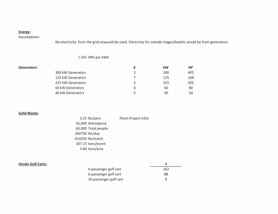
Energy:Assumptions:
1.341 HPh per kWh
Generators: # kW HP300 kW Generators 2 300 402125 kW Generators 7 125 168225 kW Generators 2 225 30260 kW Generators 6 60 8040 kW Generators 5 40 54
Solid Waste:3.15 lbs/pers (from Project info)
65,000 Attendance65,000 Total people204750 lbs/day614250 lbs/event307.13 tons/event
3.84 tons/acre
Onsite Golf Carts: #4 passenger golf cart 1626 passenger golf cart 8810 passenger golf cart 0
No electricity from the grid onwould be used. Electricity for outside stages/booths would be from generators.
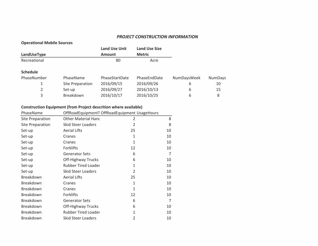
Operational Mobile Sources
LandUseTypeLand Use UnitAmount
Land Use SizeMetric
Recreational 80 Acre
SchedulePhaseNumber PhaseName PhaseStartDate PhaseEndDate NumDaysWeek NumDays
1 Site Preparation 2016/09/15 2016/09/26 6 102 Set up 2016/09/27 2016/10/13 6 153 Breakdown 2016/10/17 2016/10/25 6 8
Construction Equipment (from Project descrition where available)PhaseName OffRoadEquipmentT OffRoadEquipment UsageHoursSite Preparation Other Material Hand 2 8Site Preparation Skid Steer Loaders 2 8Set up Aerial Lifts 25 10Set up Cranes 1 10Set up Cranes 1 10Set up Forklifts 12 10Set up Generator Sets 6 7Set up Off Highway Trucks 6 10Set up Rubber Tired Loader 1 10Set up Skid Steer Loaders 2 10Breakdown Aerial Lifts 25 10Breakdown Cranes 1 10Breakdown Cranes 1 10Breakdown Forklifts 12 10Breakdown Generator Sets 6 7Breakdown Off Highway Trucks 6 10Breakdown Rubber Tired Loader 1 10Breakdown Skid Steer Loaders 2 10
PROJECT CONSTRUCTION INFORMATION

Vendor Trips (from Project description)Assume 60 totla trips during set up period, and 60 total trips during breakdown period.
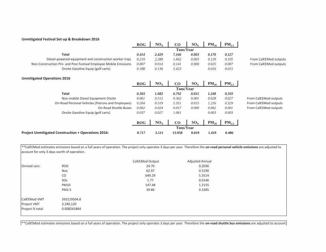
Unmitigated Festival Set up & Breakdown 2016ROG NOX CO SOX PM10 PM2.5
Total 0.414 2.429 7.166 0.003 0.170 0.1270.219 2.280 1.602 0.003 0.129 0.105 From CalEEMod outputs0.007 0.014 0.141 0.000 0.025 0.007 From CalEEMod outputs
Onsite Gasoline Equip (golf carts) 0.188 0.136 5.423 0.016 0.015
Unmitigated Operations 2016ROG NOX CO SOX PM10 PM2.5
Total 0.303 1.082 6.792 0.015 1.248 0.359Non mobile Diesel Equipment Onsite 0.061 0.512 0.362 0.001 0.028 0.027 From CalEEMod outputs
0.204 0.519 5.351 0.015 1.216 0.329 From CalEEMod outputsOn Road Shuttle Buses 0.002 0.024 0.017 0.000 0.002 0.001 From CalEEMod outputs
Onsite Gasoline Equip (golf carts) 0.037 0.027 1.061 0.003 0.003
ROG NOX CO SOX PM10 PM2.5
Project Unmitigated Construction + Operations 2016: 0.717 3.511 13.958 0.019 1.419 0.486
Adjusted AnnualOnroad cars: ROG
NoxCOSOxPM10PM2.5
CalEEMod VMT 393129504.8Project VMT 3,240,120Project % total 0.008241864
Tons/Year
Diesel powered equipment and construction worker trips
649.29 5.3514
CalEEMod Output
Non Construction Pre and Post Festival Employee Mobile Emisisons
Tons/Year
On Road Personal Vehicles (Patrons and Employees)
24.70 0.203662.97 0.5190
**CalEEMod estimates emissions based on a full years of operation. The project only operates 3 days per year. Therefore the on road personal vehicle emissions are adjusted toaccount for only 3 days worth of operation.
0.01461.21550.3285
1.77147.4839.86
Tons/Year
**CalEEMod estimates emissions based on a full years of operation. The project only operates 3 days per year. Therefore the on road shuttle bus emissions are adjusted to account
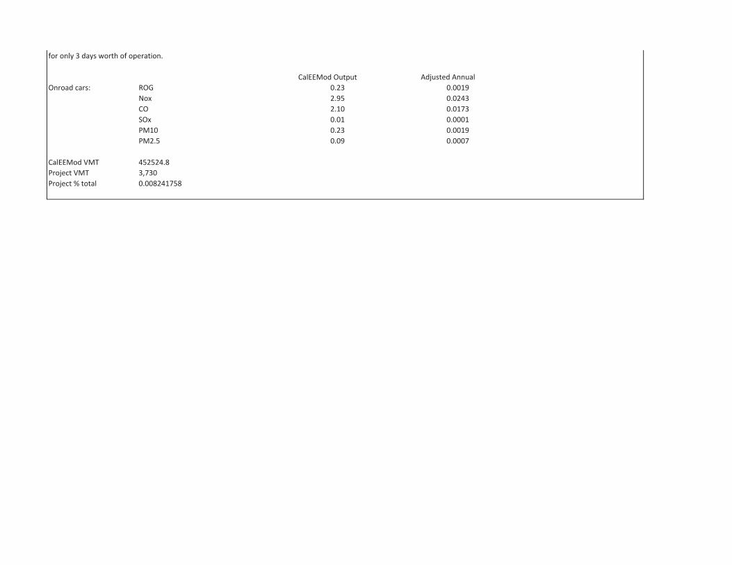
Adjusted AnnualOnroad cars: ROG
NoxCOSOxPM10PM2.5
CalEEMod VMT 452524.8Project VMT 3,730Project % total 0.008241758
0.09 0.0007
2.10 0.01730.01 0.00010.23 0.0019
for only 3 days worth of operation.
CalEEMod Output0.23 0.00192.95 0.0243
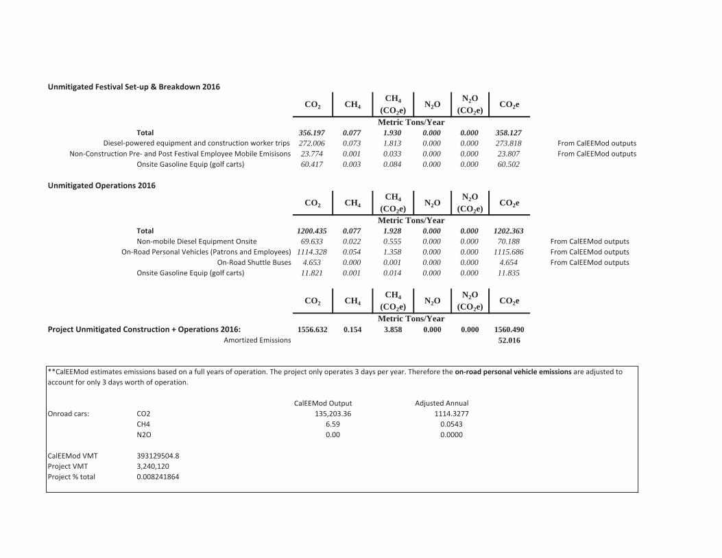
Unmitigated Festival Set up & Breakdown 2016
CO2 CH4CH4
(CO2e)N2O
N2O(CO2e)
CO2e
Total 356.197 0.077 1.930 0.000 0.000 358.127272.006 0.073 1.813 0.000 0.000 273.818 From CalEEMod outputs23.774 0.001 0.033 0.000 0.000 23.807 From CalEEMod outputs
Onsite Gasoline Equip (golf carts) 60.417 0.003 0.084 0.000 0.000 60.502
Unmitigated Operations 2016
CO2 CH4CH4
(CO2e)N2O
N2O(CO2e)
CO2e
Total 1200.435 0.077 1.928 0.000 0.000 1202.363Non mobile Diesel Equipment Onsite 69.633 0.022 0.555 0.000 0.000 70.188 From CalEEMod outputs
1114.328 0.054 1.358 0.000 0.000 1115.686 From CalEEMod outputsOn Road Shuttle Buses 4.653 0.000 0.001 0.000 0.000 4.654 From CalEEMod outputs
Onsite Gasoline Equip (golf carts) 11.821 0.001 0.014 0.000 0.000 11.835
CO2 CH4CH4
(CO2e)N2O
N2O(CO2e)
CO2e
Project Unmitigated Construction + Operations 2016: 1556.632 0.154 3.858 0.000 0.000 1560.490Amortized Emissions 52.016
Adjusted AnnualOnroad cars: CO2
CH4N2O
CalEEMod VMT 393129504.8Project VMT 3,240,120Project % total 0.008241864
0.00 0.0000
Metric Tons/Year
**CalEEMod estimates emissions based on a full years of operation. The project only operates 3 days per year. Therefore the on road personal vehicle emissions are adjusted toaccount for only 3 days worth of operation.
CalEEMod Output135,203.36 1114.3277
6.59 0.0543
Metric Tons/Year
Non Construction Pre and Post Festival Employee Mobile Emisisons
Metric Tons/Year
On Road Personal Vehicles (Patrons and Employees)
Diesel powered equipment and construction worker trips

Adjusted AnnualOnroad cars: CO2
CH4N2O
CalEEMod VMT 452524.8Project VMT 3,730Project % total 0.008241758
**CalEEMod estimates emissions based on a full years of operation. The project only operates 3 days per year. Therefore the on road shuttle bus emissions are adjusted to accountfor only 3 days worth of operation.
CalEEMod Output564.55 4.65290.00 0.00000.00 0.0000
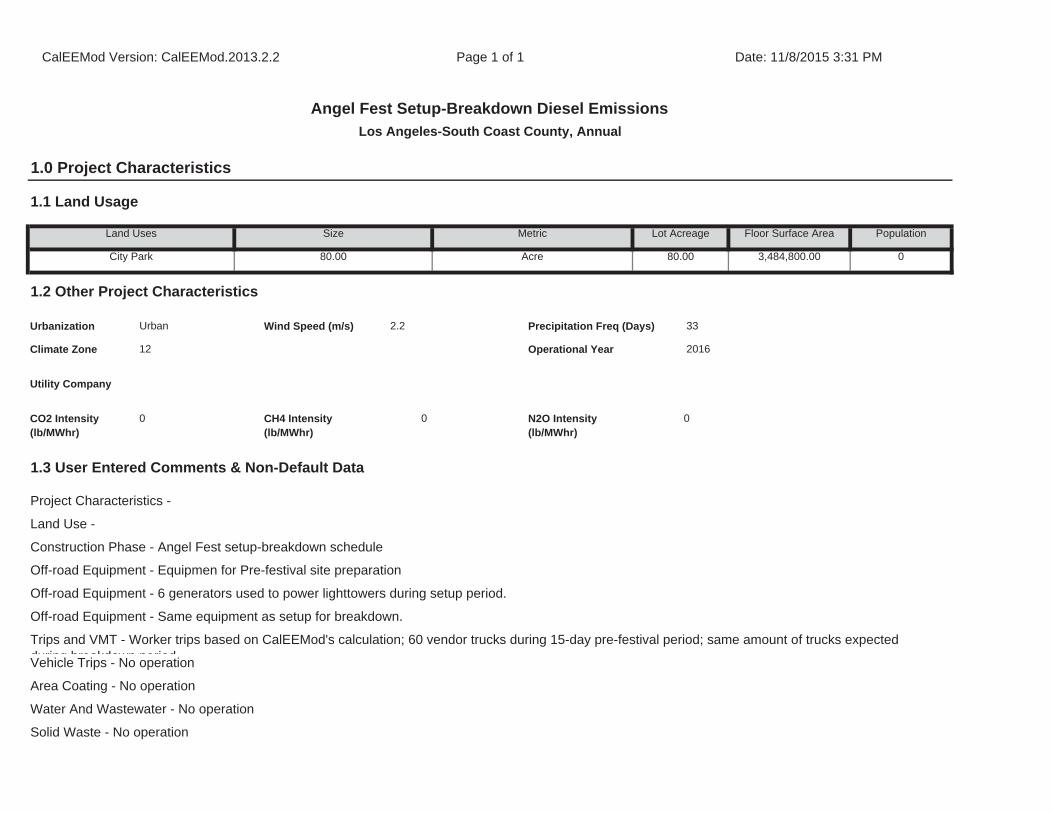
Off-road Equipment - Same equipment as setup for breakdown.
Trips and VMT - Worker trips based on CalEEMod's calculation; 60 vendor trucks during 15-day pre-festival period; same amount of trucks expected during breakdown periodVehicle Trips - No operation
Area Coating - No operation
Water And Wastewater - No operation
Solid Waste - No operation
1.3 User Entered Comments & Non-Default Data
Project Characteristics -
Land Use -
Construction Phase - Angel Fest setup-breakdown schedule
Off-road Equipment - Equipmen for Pre-festival site preparation
Off-road Equipment - 6 generators used to power lighttowers during setup period.
CO2 Intensity (lb/MWhr)
0 CH4 Intensity (lb/MWhr)
0 N2O Intensity (lb/MWhr)
0
33
Climate Zone 12 Operational Year 2016
Utility Company
1.2 Other Project Characteristics
Urbanization Urban Wind Speed (m/s) 2.2 Precipitation Freq (Days)
Population
City Park 80.00 Acre 80.00 3,484,800.00 0
1.1 Land Usage
Land Uses Size Metric Lot Acreage Floor Surface Area
CalEEMod Version: CalEEMod.2013.2.2 Page 1 of 1 Date: 11/8/2015 3:31 PM
Angel Fest Setup-Breakdown Diesel EmissionsLos Angeles-South Coast County, Annual
1.0 Project Characteristics
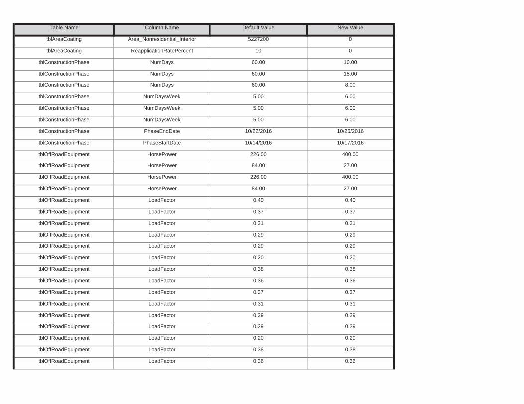
tblOffRoadEquipment LoadFactor 0.38 0.38
tblOffRoadEquipment LoadFactor 0.36 0.36
tblOffRoadEquipment LoadFactor 0.29 0.29
tblOffRoadEquipment LoadFactor 0.20 0.20
tblOffRoadEquipment LoadFactor 0.31 0.31
tblOffRoadEquipment LoadFactor 0.29 0.29
tblOffRoadEquipment LoadFactor 0.36 0.36
tblOffRoadEquipment LoadFactor 0.37 0.37
tblOffRoadEquipment LoadFactor 0.20 0.20
tblOffRoadEquipment LoadFactor 0.38 0.38
tblOffRoadEquipment LoadFactor 0.29 0.29
tblOffRoadEquipment LoadFactor 0.29 0.29
tblOffRoadEquipment LoadFactor 0.37 0.37
tblOffRoadEquipment LoadFactor 0.31 0.31
tblOffRoadEquipment HorsePower 84.00 27.00
tblOffRoadEquipment LoadFactor 0.40 0.40
tblOffRoadEquipment HorsePower 84.00 27.00
tblOffRoadEquipment HorsePower 226.00 400.00
tblConstructionPhase PhaseStartDate 10/14/2016 10/17/2016
tblOffRoadEquipment HorsePower 226.00 400.00
tblConstructionPhase NumDaysWeek 5.00 6.00
tblConstructionPhase PhaseEndDate 10/22/2016 10/25/2016
tblConstructionPhase NumDaysWeek 5.00 6.00
tblConstructionPhase NumDaysWeek 5.00 6.00
tblConstructionPhase NumDays 60.00 15.00
tblConstructionPhase NumDays 60.00 8.00
tblAreaCoating ReapplicationRatePercent 10 0
tblConstructionPhase NumDays 60.00 10.00
Table Name Column Name Default Value New Value
tblAreaCoating Area_Nonresidential_Interior 5227200 0
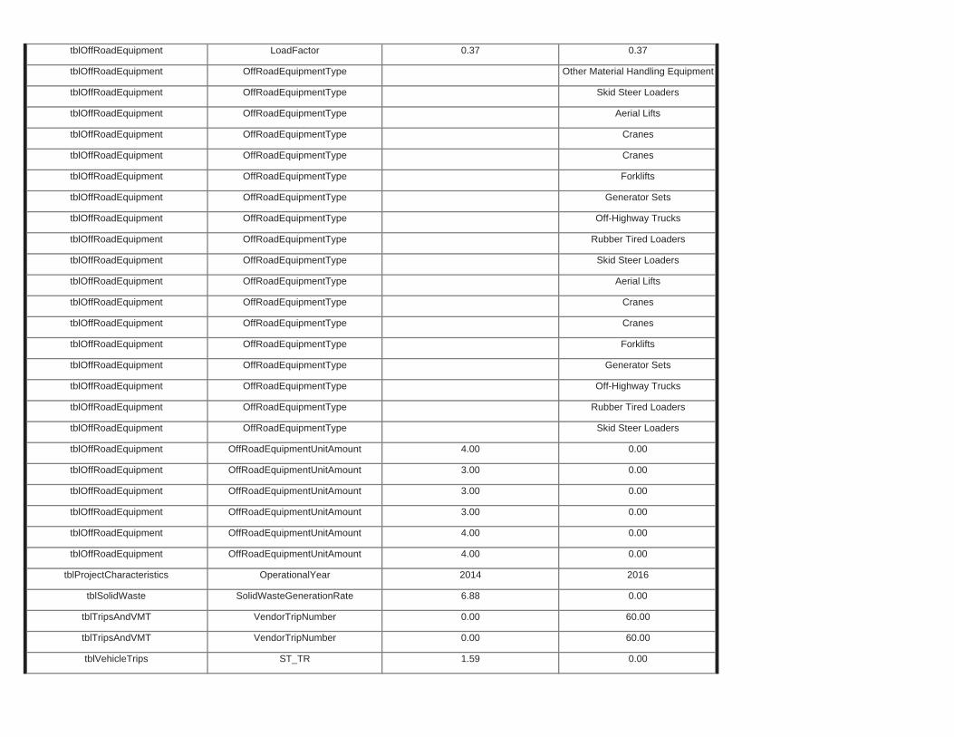
tblTripsAndVMT VendorTripNumber 0.00 60.00
tblVehicleTrips ST_TR 1.59 0.00
tblSolidWaste SolidWasteGenerationRate 6.88 0.00
tblTripsAndVMT VendorTripNumber 0.00 60.00
tblOffRoadEquipment OffRoadEquipmentUnitAmount 4.00 0.00
tblProjectCharacteristics OperationalYear 2014 2016
tblOffRoadEquipment OffRoadEquipmentUnitAmount 3.00 0.00
tblOffRoadEquipment OffRoadEquipmentUnitAmount 4.00 0.00
tblOffRoadEquipment OffRoadEquipmentUnitAmount 3.00 0.00
tblOffRoadEquipment OffRoadEquipmentUnitAmount 3.00 0.00
tblOffRoadEquipment OffRoadEquipmentType Skid Steer Loaders
tblOffRoadEquipment OffRoadEquipmentUnitAmount 4.00 0.00
tblOffRoadEquipment OffRoadEquipmentType Off-Highway Trucks
tblOffRoadEquipment OffRoadEquipmentType Rubber Tired Loaders
tblOffRoadEquipment OffRoadEquipmentType Forklifts
tblOffRoadEquipment OffRoadEquipmentType Generator Sets
tblOffRoadEquipment OffRoadEquipmentType Cranes
tblOffRoadEquipment OffRoadEquipmentType Cranes
tblOffRoadEquipment OffRoadEquipmentType Skid Steer Loaders
tblOffRoadEquipment OffRoadEquipmentType Aerial Lifts
tblOffRoadEquipment LoadFactor 0.37 0.37
tblOffRoadEquipment OffRoadEquipmentType Other Material Handling Equipment
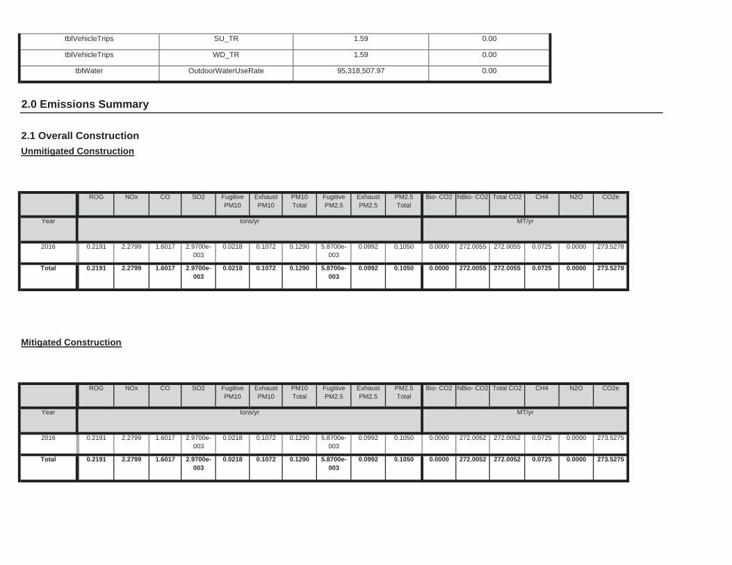
0.0000 272.0052 272.0052 0.0725 0.0000 273.52750.0218 0.1072 0.1290 5.8700e-003
0.0992 0.1050Total 0.2191 2.2799 1.6017 2.9700e-003
0.0000 272.0052 272.0052 0.0725 0.0000 273.52750.0218 0.1072 0.1290 5.8700e-003
0.0992 0.10502016 0.2191 2.2799 1.6017 2.9700e-003
Total CO2 CH4 N2O CO2e
Year tons/yr MT/yr
PM10Total
FugitivePM2.5
ExhaustPM2.5
PM2.5Total
Bio- CO2 NBio- CO2
Mitigated Construction
ROG NOx CO SO2 Fugitive PM10
ExhaustPM10
0.0000 272.0055 272.0055 0.0725 0.0000 273.52780.0218 0.1072 0.1290 5.8700e-003
0.0992 0.1050Total 0.2191 2.2799 1.6017 2.9700e-003
0.0000 272.0055 272.0055 0.0725 0.0000 273.52780.0218 0.1072 0.1290 5.8700e-003
0.0992 0.10502016 0.2191 2.2799 1.6017 2.9700e-003
CH4 N2O CO2e
Year tons/yr MT/yr
FugitivePM2.5
ExhaustPM2.5
PM2.5Total
Bio- CO2 NBio- CO2 Total CO2
Unmitigated Construction
ROG NOx CO SO2 Fugitive PM10
ExhaustPM10
PM10Total
tblWater OutdoorWaterUseRate 95,318,507.97 0.00
2.0 Emissions Summary
2.1 Overall Construction
tblVehicleTrips SU_TR 1.59 0.00
tblVehicleTrips WD_TR 1.59 0.00
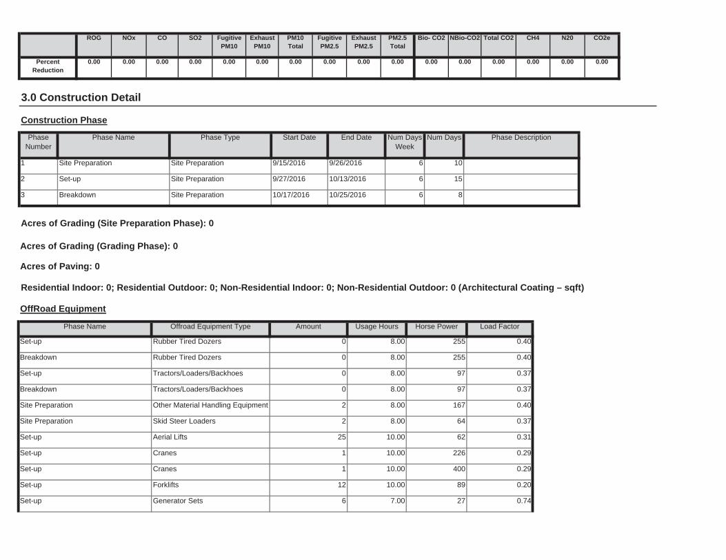
Set-up Generator Sets 6 7.00 27 0.74
Set-up Forklifts 12 10.00 89 0.20
Set-up Cranes 1 10.00 400 0.29
Set-up Cranes 1 10.00 226 0.29
Set-up Aerial Lifts 25 10.00 62 0.31
Site Preparation Skid Steer Loaders 2 8.00 64 0.37
Site Preparation Other Material Handling Equipment 2 8.00 167 0.40
Breakdown Tractors/Loaders/Backhoes 0 8.00 97 0.37
Set-up Tractors/Loaders/Backhoes 0 8.00 97 0.37
Breakdown Rubber Tired Dozers 0 8.00 255 0.40
Load Factor
Set-up Rubber Tired Dozers 0 8.00 255 0.40
OffRoad Equipment
Phase Name Offroad Equipment Type Amount Usage Hours Horse Power
8
Acres of Grading (Site Preparation Phase): 0
Acres of Grading (Grading Phase): 0
Acres of Paving: 0
Residential Indoor: 0; Residential Outdoor: 0; Non-Residential Indoor: 0; Non-Residential Outdoor: 0 (Architectural Coating – sqft)
3 Breakdown Site Preparation 10/17/2016 10/25/2016 6
10
2 Set-up Site Preparation 9/27/2016 10/13/2016 6 15
End Date Num Days Week
Num Days Phase Description
1 Site Preparation Site Preparation 9/15/2016 9/26/2016 6
3.0 Construction Detail
Construction Phase
PhaseNumber
Phase Name Phase Type Start Date
0.00 0.00 0.00 0.00 0.00 0.000.00 0.00 0.00 0.00 0.00 0.00
NBio-CO2 Total CO2 CH4 N20 CO2e
PercentReduction
0.00 0.00 0.00 0.00
ExhaustPM10
PM10Total
FugitivePM2.5
ExhaustPM2.5
PM2.5Total
Bio- CO2ROG NOx CO SO2 Fugitive PM10
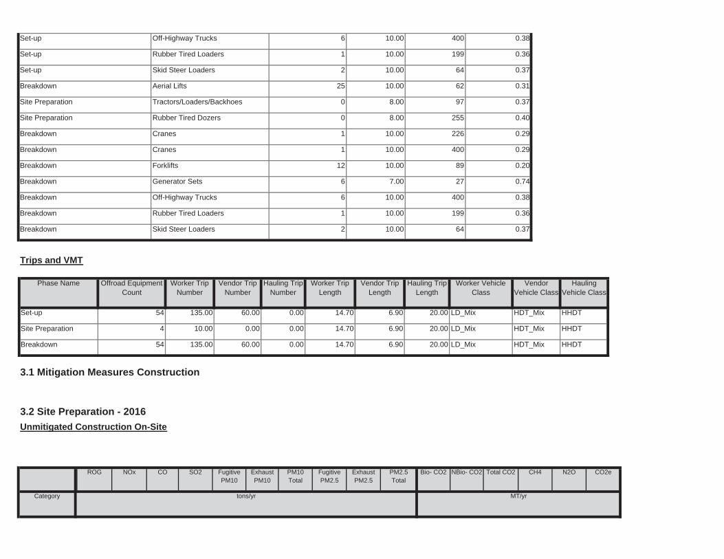
Total CO2 CH4 N2O CO2e
Category tons/yr MT/yr
PM10Total
FugitivePM2.5
ExhaustPM2.5
PM2.5Total
Bio- CO2 NBio- CO2
3.2 Site Preparation - 2016
Unmitigated Construction On-Site
ROG NOx CO SO2 Fugitive PM10
ExhaustPM10
6.90 20.00 LD_Mix HDT_Mix HHDT
3.1 Mitigation Measures Construction
Breakdown 54 135.00 60.00 0.00 14.70
14.70 6.90 20.00 LD_Mix HDT_Mix HHDT
6.90 20.00 LD_Mix HDT_Mix HHDT
Site Preparation 4 10.00 0.00 0.00
Set-up 54 135.00 60.00 0.00 14.70
Worker Trip Length
Vendor Trip Length
Hauling Trip Length
Worker Vehicle Class
VendorVehicle Class
HaulingVehicle Class
Trips and VMT
Phase Name Offroad Equipment Count
Worker Trip Number
Vendor Trip Number
Hauling Trip Number
Breakdown Skid Steer Loaders 2 10.00 64 0.37
Breakdown Rubber Tired Loaders 1 10.00 199 0.36
Breakdown Off-Highway Trucks 6 10.00 400 0.38
Breakdown Generator Sets 6 7.00 27 0.74
Breakdown Forklifts 12 10.00 89 0.20
Breakdown Cranes 1 10.00 400 0.29
Breakdown Cranes 1 10.00 226 0.29
Site Preparation Rubber Tired Dozers 0 8.00 255 0.40
Site Preparation Tractors/Loaders/Backhoes 0 8.00 97 0.37
Breakdown Aerial Lifts 25 10.00 62 0.31
Set-up Skid Steer Loaders 2 10.00 64 0.37
Set-up Rubber Tired Loaders 1 10.00 199 0.36
Set-up Off-Highway Trucks 6 10.00 400 0.38
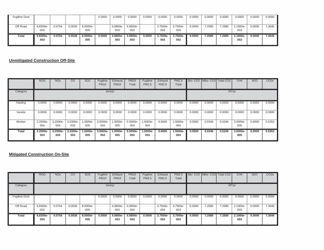
0.0000 7.2585 7.2585 2.1900e-003
0.0000 7.30450.0000 4.0800e-003
4.0800e-003
0.0000 3.7500e-003
3.7500e-003
Total 6.8300e-003
0.0754 0.0536 8.0000e-005
0.0000 7.2585 7.2585 2.1900e-003
0.0000 7.30454.0800e-003
4.0800e-003
3.7500e-003
3.7500e-003
Off-Road 6.8300e-003
0.0754 0.0536 8.0000e-005
0.0000 0.0000 0.0000 0.0000 0.0000 0.00000.0000 0.0000 0.0000 0.0000 0.0000 0.0000Fugitive Dust
Total CO2 CH4 N2O CO2e
Category tons/yr MT/yr
PM10Total
FugitivePM2.5
ExhaustPM2.5
PM2.5Total
Bio- CO2 NBio- CO2
Mitigated Construction On-Site
ROG NOx CO SO2 Fugitive PM10
ExhaustPM10
0.0000 0.5346 0.5346 3.0000e-005
0.0000 0.53535.5000e-004
1.0000e-005
5.5000e-004
1.5000e-004
0.0000 1.5000e-004
Total 2.2000e-004
3.2000e-004
3.3300e-003
1.0000e-005
0.0000 0.5346 0.5346 3.0000e-005
0.0000 0.53535.5000e-004
1.0000e-005
5.5000e-004
1.5000e-004
0.0000 1.5000e-004
Worker 2.2000e-004
3.2000e-004
3.3300e-003
1.0000e-005
0.0000 0.0000 0.0000 0.0000 0.0000 0.00000.0000 0.0000 0.0000 0.0000 0.0000 0.0000Vendor 0.0000 0.0000 0.0000 0.0000
0.0000 0.0000 0.0000 0.0000 0.0000 0.00000.0000 0.0000 0.0000 0.0000 0.0000 0.0000Hauling 0.0000 0.0000 0.0000 0.0000
Total CO2 CH4 N2O CO2e
Category tons/yr MT/yr
PM10Total
FugitivePM2.5
ExhaustPM2.5
PM2.5Total
Bio- CO2 NBio- CO2
Unmitigated Construction Off-Site
ROG NOx CO SO2 Fugitive PM10
ExhaustPM10
0.0000 7.2585 7.2585 2.1900e-003
0.0000 7.30450.0000 4.0800e-003
4.0800e-003
0.0000 3.7500e-003
3.7500e-003
Total 6.8300e-003
0.0754 0.0536 8.0000e-005
0.0000 7.2585 7.2585 2.1900e-003
0.0000 7.30454.0800e-003
4.0800e-003
3.7500e-003
3.7500e-003
Off-Road 6.8300e-003
0.0754 0.0536 8.0000e-005
0.0000 0.0000 0.0000 0.0000 0.0000 0.00000.0000 0.0000 0.0000 0.0000 0.0000 0.0000Fugitive Dust
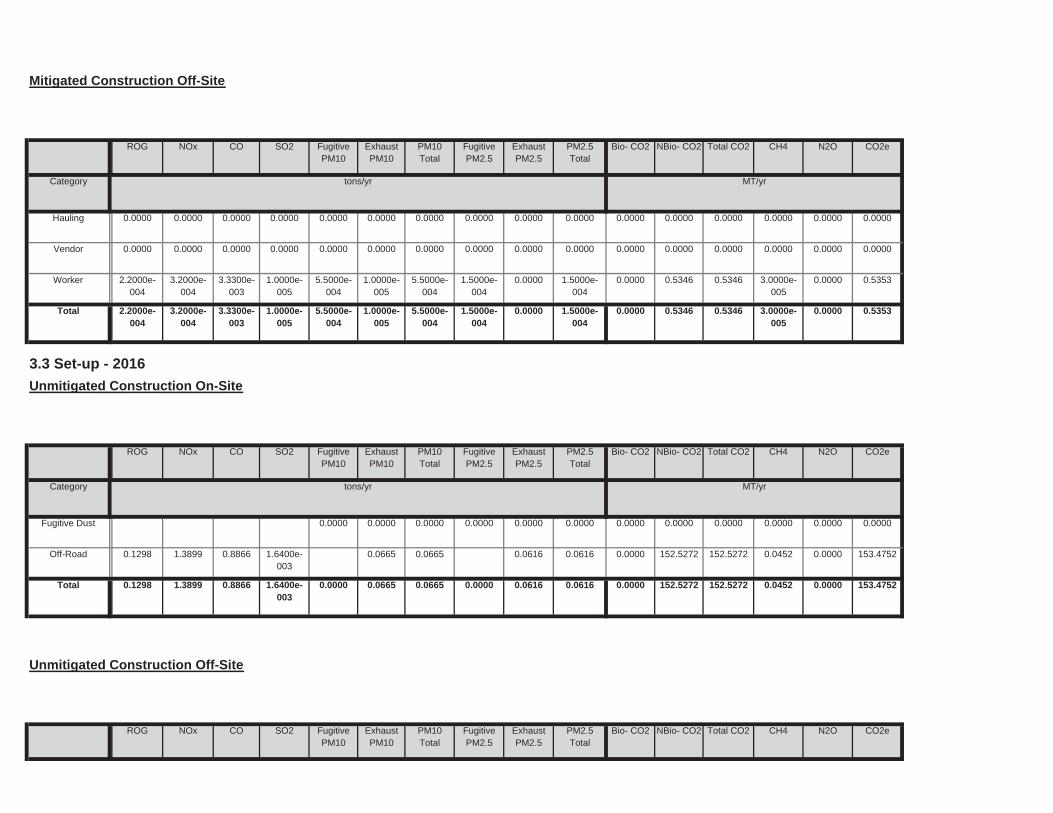
Total CO2 CH4 N2O CO2ePM10Total
FugitivePM2.5
ExhaustPM2.5
PM2.5Total
Bio- CO2 NBio- CO2
Unmitigated Construction Off-Site
ROG NOx CO SO2 Fugitive PM10
ExhaustPM10
0.0000 152.5272 152.5272 0.0452 0.0000 153.47520.0000 0.0665 0.0665 0.0000 0.0616 0.0616Total 0.1298 1.3899 0.8866 1.6400e-003
0.0000 152.5272 152.5272 0.0452 0.0000 153.47520.0665 0.0665 0.0616 0.0616Off-Road 0.1298 1.3899 0.8866 1.6400e-003
0.0000 0.0000 0.0000 0.0000 0.0000 0.00000.0000 0.0000 0.0000 0.0000 0.0000 0.0000Fugitive Dust
Total CO2 CH4 N2O CO2e
Category tons/yr MT/yr
PM10Total
FugitivePM2.5
ExhaustPM2.5
PM2.5Total
Bio- CO2 NBio- CO2
3.3 Set-up - 2016
Unmitigated Construction On-Site
ROG NOx CO SO2 Fugitive PM10
ExhaustPM10
0.0000 0.5346 0.5346 3.0000e-005
0.0000 0.53535.5000e-004
1.0000e-005
5.5000e-004
1.5000e-004
0.0000 1.5000e-004
Total 2.2000e-004
3.2000e-004
3.3300e-003
1.0000e-005
0.0000 0.5346 0.5346 3.0000e-005
0.0000 0.53535.5000e-004
1.0000e-005
5.5000e-004
1.5000e-004
0.0000 1.5000e-004
Worker 2.2000e-004
3.2000e-004
3.3300e-003
1.0000e-005
0.0000 0.0000 0.0000 0.0000 0.0000 0.00000.0000 0.0000 0.0000 0.0000 0.0000 0.0000Vendor 0.0000 0.0000 0.0000 0.0000
0.0000 0.0000 0.0000 0.0000 0.0000 0.00000.0000 0.0000 0.0000 0.0000 0.0000 0.0000Hauling 0.0000 0.0000 0.0000 0.0000
Total CO2 CH4 N2O CO2e
Category tons/yr MT/yr
PM10Total
FugitivePM2.5
ExhaustPM2.5
PM2.5Total
Bio- CO2 NBio- CO2
Mitigated Construction Off-Site
ROG NOx CO SO2 Fugitive PM10
ExhaustPM10
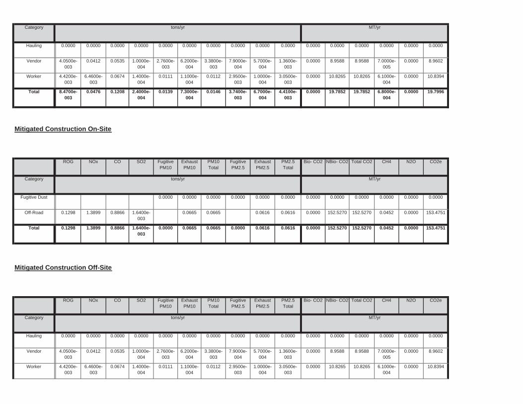
0.0000 10.8265 10.8265 6.1000e-004
0.0000 10.83940.0111 1.1000e-004
0.0112 2.9500e-003
1.0000e-004
3.0500e-003
Worker 4.4200e-003
6.4600e-003
0.0674 1.4000e-004
0.0000 8.9588 8.9588 7.0000e-005
0.0000 8.96022.7600e-003
6.2000e-004
3.3800e-003
7.9000e-004
5.7000e-004
1.3600e-003
Vendor 4.0500e-003
0.0412 0.0535 1.0000e-004
0.0000 0.0000 0.0000 0.0000 0.0000 0.00000.0000 0.0000 0.0000 0.0000 0.0000 0.0000Hauling 0.0000 0.0000 0.0000 0.0000
Total CO2 CH4 N2O CO2e
Category tons/yr MT/yr
PM10Total
FugitivePM2.5
ExhaustPM2.5
PM2.5Total
Bio- CO2 NBio- CO2
Mitigated Construction Off-Site
ROG NOx CO SO2 Fugitive PM10
ExhaustPM10
0.0000 152.5270 152.5270 0.0452 0.0000 153.47510.0000 0.0665 0.0665 0.0000 0.0616 0.0616Total 0.1298 1.3899 0.8866 1.6400e-003
0.0000 152.5270 152.5270 0.0452 0.0000 153.47510.0665 0.0665 0.0616 0.0616Off-Road 0.1298 1.3899 0.8866 1.6400e-003
0.0000 0.0000 0.0000 0.0000 0.0000 0.00000.0000 0.0000 0.0000 0.0000 0.0000 0.0000Fugitive Dust
Total CO2 CH4 N2O CO2e
Category tons/yr MT/yr
PM10Total
FugitivePM2.5
ExhaustPM2.5
PM2.5Total
Bio- CO2 NBio- CO2
Mitigated Construction On-Site
ROG NOx CO SO2 Fugitive PM10
ExhaustPM10
0.0000 19.7852 19.7852 6.8000e-004
0.0000 19.79960.0139 7.3000e-004
0.0146 3.7400e-003
6.7000e-004
4.4100e-003
Total 8.4700e-003
0.0476 0.1208 2.4000e-004
0.0000 10.8265 10.8265 6.1000e-004
0.0000 10.83940.0111 1.1000e-004
0.0112 2.9500e-003
1.0000e-004
3.0500e-003
Worker 4.4200e-003
6.4600e-003
0.0674 1.4000e-004
0.0000 8.9588 8.9588 7.0000e-005
0.0000 8.96022.7600e-003
6.2000e-004
3.3800e-003
7.9000e-004
5.7000e-004
1.3600e-003
Vendor 4.0500e-003
0.0412 0.0535 1.0000e-004
0.0000 0.0000 0.0000 0.0000 0.0000 0.00000.0000 0.0000 0.0000 0.0000 0.0000 0.0000Hauling 0.0000 0.0000 0.0000 0.0000
Category tons/yr MT/yr
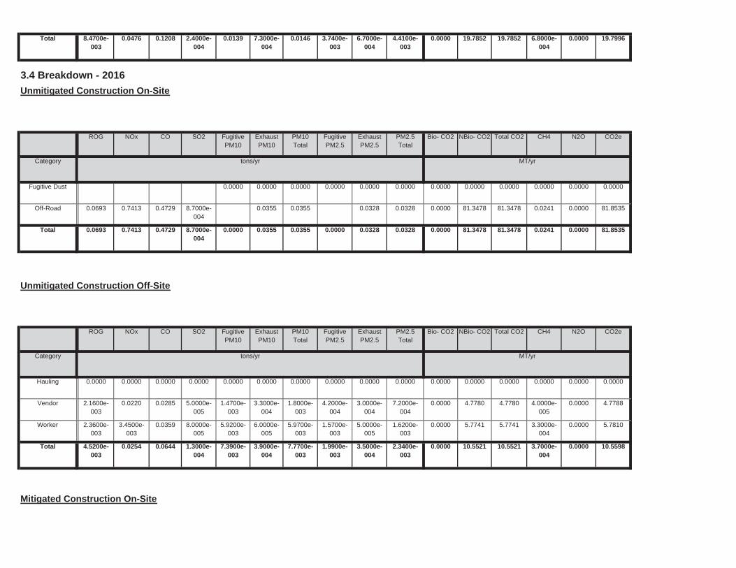
Mitigated Construction On-Site
0.0000 10.5521 10.5521 3.7000e-004
0.0000 10.55987.3900e-003
3.9000e-004
7.7700e-003
1.9900e-003
3.5000e-004
2.3400e-003
Total 4.5200e-003
0.0254 0.0644 1.3000e-004
0.0000 5.7741 5.7741 3.3000e-004
0.0000 5.78105.9200e-003
6.0000e-005
5.9700e-003
1.5700e-003
5.0000e-005
1.6200e-003
Worker 2.3600e-003
3.4500e-003
0.0359 8.0000e-005
0.0000 4.7780 4.7780 4.0000e-005
0.0000 4.77881.4700e-003
3.3000e-004
1.8000e-003
4.2000e-004
3.0000e-004
7.2000e-004
Vendor 2.1600e-003
0.0220 0.0285 5.0000e-005
0.0000 0.0000 0.0000 0.0000 0.0000 0.00000.0000 0.0000 0.0000 0.0000 0.0000 0.0000Hauling 0.0000 0.0000 0.0000 0.0000
Total CO2 CH4 N2O CO2e
Category tons/yr MT/yr
PM10Total
FugitivePM2.5
ExhaustPM2.5
PM2.5Total
Bio- CO2 NBio- CO2
Unmitigated Construction Off-Site
ROG NOx CO SO2 Fugitive PM10
ExhaustPM10
0.0000 81.3478 81.3478 0.0241 0.0000 81.85350.0000 0.0355 0.0355 0.0000 0.0328 0.0328Total 0.0693 0.7413 0.4729 8.7000e-004
0.0000 81.3478 81.3478 0.0241 0.0000 81.85350.0355 0.0355 0.0328 0.0328Off-Road 0.0693 0.7413 0.4729 8.7000e-004
0.0000 0.0000 0.0000 0.0000 0.0000 0.00000.0000 0.0000 0.0000 0.0000 0.0000 0.0000Fugitive Dust
Total CO2 CH4 N2O CO2e
Category tons/yr MT/yr
PM10Total
FugitivePM2.5
ExhaustPM2.5
PM2.5Total
Bio- CO2 NBio- CO2
3.4 Breakdown - 2016
Unmitigated Construction On-Site
ROG NOx CO SO2 Fugitive PM10
ExhaustPM10
0.0000 19.7852 19.7852 6.8000e-004
0.0000 19.79960.0139 7.3000e-004
0.0146 3.7400e-003
6.7000e-004
4.4100e-003
Total 8.4700e-003
0.0476 0.1208 2.4000e-004
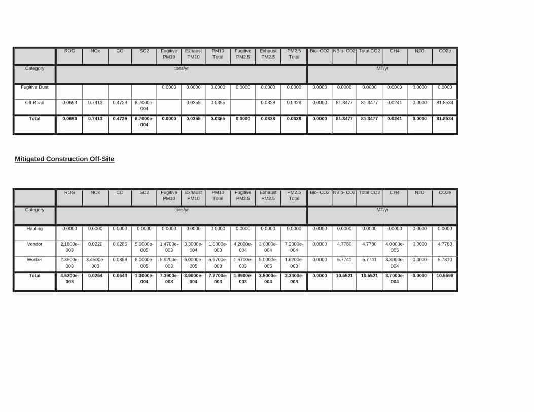
0.0000 10.5521 10.5521 3.7000e-004
0.0000 10.55987.3900e-003
3.9000e-004
7.7700e-003
1.9900e-003
3.5000e-004
2.3400e-003
Total 4.5200e-003
0.0254 0.0644 1.3000e-004
0.0000 5.7741 5.7741 3.3000e-004
0.0000 5.78105.9200e-003
6.0000e-005
5.9700e-003
1.5700e-003
5.0000e-005
1.6200e-003
Worker 2.3600e-003
3.4500e-003
0.0359 8.0000e-005
0.0000 4.7780 4.7780 4.0000e-005
0.0000 4.77881.4700e-003
3.3000e-004
1.8000e-003
4.2000e-004
3.0000e-004
7.2000e-004
Vendor 2.1600e-003
0.0220 0.0285 5.0000e-005
0.0000 0.0000 0.0000 0.0000 0.0000 0.00000.0000 0.0000 0.0000 0.0000 0.0000 0.0000Hauling 0.0000 0.0000 0.0000 0.0000
Total CO2 CH4 N2O CO2e
Category tons/yr MT/yr
PM10Total
FugitivePM2.5
ExhaustPM2.5
PM2.5Total
Bio- CO2 NBio- CO2
Mitigated Construction Off-Site
ROG NOx CO SO2 Fugitive PM10
ExhaustPM10
0.0000 81.3477 81.3477 0.0241 0.0000 81.85340.0000 0.0355 0.0355 0.0000 0.0328 0.0328Total 0.0693 0.7413 0.4729 8.7000e-004
0.0000 81.3477 81.3477 0.0241 0.0000 81.85340.0355 0.0355 0.0328 0.0328Off-Road 0.0693 0.7413 0.4729 8.7000e-004
0.0000 0.0000 0.0000 0.0000 0.0000 0.00000.0000 0.0000 0.0000 0.0000 0.0000 0.0000Fugitive Dust
Total CO2 CH4 N2O CO2e
Category tons/yr MT/yr
PM10Total
FugitivePM2.5
ExhaustPM2.5
PM2.5Total
Bio- CO2 NBio- CO2ROG NOx CO SO2 Fugitive PM10
ExhaustPM10
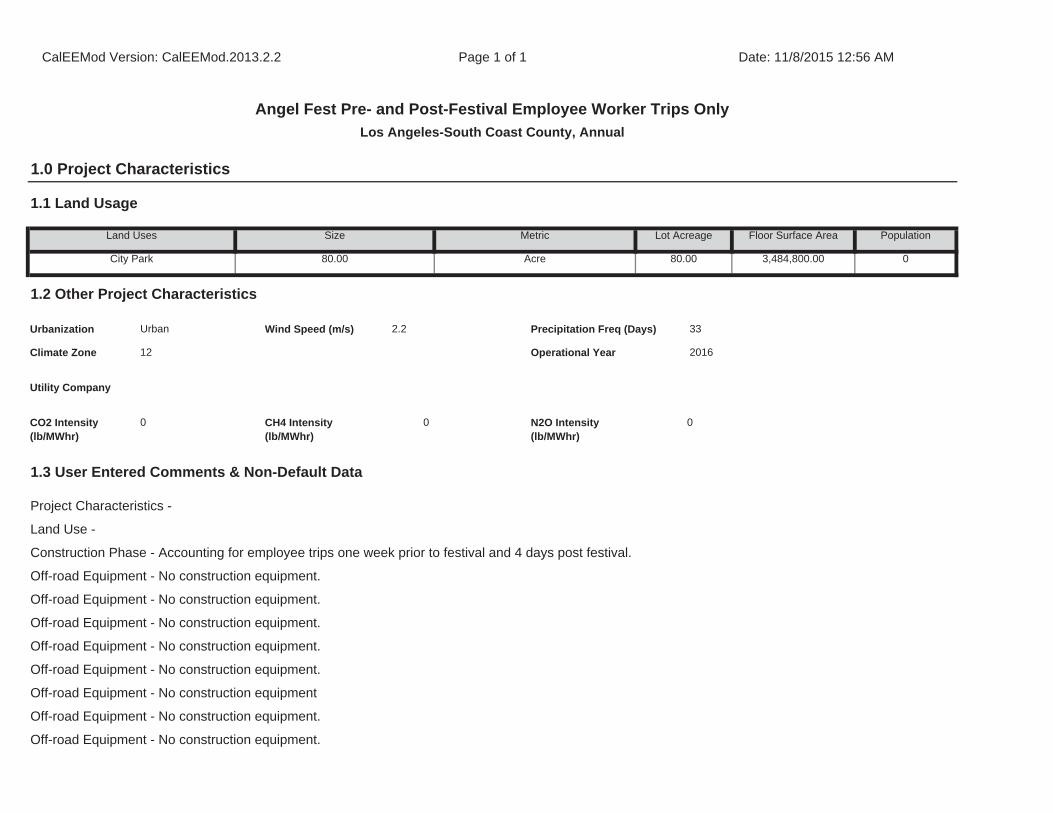
Off-road Equipment - No construction equipment.
Off-road Equipment - No construction equipment.
Off-road Equipment - No construction equipment.
Off-road Equipment - No construction equipment
Off-road Equipment - No construction equipment.
Off-road Equipment - No construction equipment.
1.3 User Entered Comments & Non-Default Data
Project Characteristics -
Land Use -
Construction Phase - Accounting for employee trips one week prior to festival and 4 days post festival.
Off-road Equipment - No construction equipment.
Off-road Equipment - No construction equipment.
CO2 Intensity (lb/MWhr)
0 CH4 Intensity (lb/MWhr)
0 N2O Intensity (lb/MWhr)
0
33
Climate Zone 12 Operational Year 2016
Utility Company
1.2 Other Project Characteristics
Urbanization Urban Wind Speed (m/s) 2.2 Precipitation Freq (Days)
Population
City Park 80.00 Acre 80.00 3,484,800.00 0
1.1 Land Usage
Land Uses Size Metric Lot Acreage Floor Surface Area
CalEEMod Version: CalEEMod.2013.2.2 Page 1 of 1 Date: 11/8/2015 12:56 AM
Angel Fest Pre- and Post-Festival Employee Worker Trips Only
Los Angeles-South Coast County, Annual
1.0 Project Characteristics
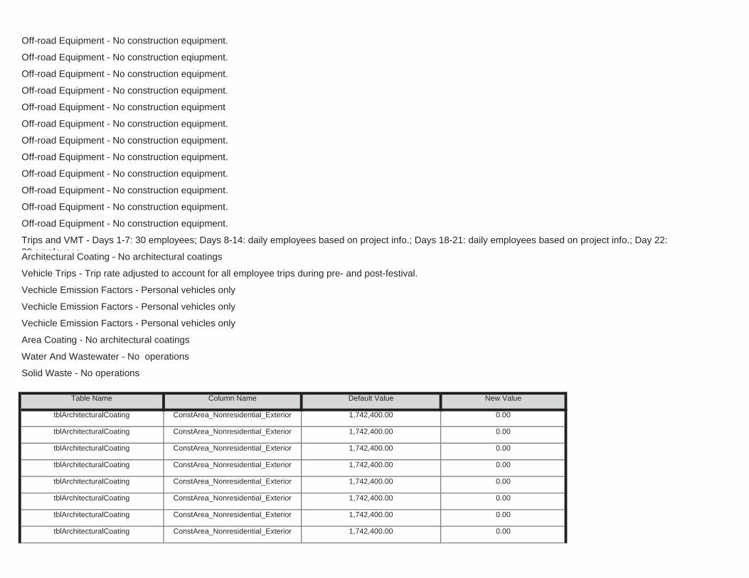
tblArchitecturalCoating ConstArea_Nonresidential_Exterior 1,742,400.00 0.00
tblArchitecturalCoating ConstArea_Nonresidential_Exterior 1,742,400.00 0.00
tblArchitecturalCoating ConstArea_Nonresidential_Exterior 1,742,400.00 0.00
tblArchitecturalCoating ConstArea_Nonresidential_Exterior 1,742,400.00 0.00
tblArchitecturalCoating ConstArea_Nonresidential_Exterior 1,742,400.00 0.00
tblArchitecturalCoating ConstArea_Nonresidential_Exterior 1,742,400.00 0.00
tblArchitecturalCoating ConstArea_Nonresidential_Exterior 1,742,400.00 0.00
tblArchitecturalCoating ConstArea_Nonresidential_Exterior 1,742,400.00 0.00
Area Coating - No architectural coatings
Water And Wastewater - No operations
Solid Waste - No operations
Table Name Column Name Default Value New Value
Trips and VMT - Days 1-7: 30 employees; Days 8-14: daily employees based on project info.; Days 18-21: daily employees based on project info.; Day 22: 30 employeesArchitectural Coating - No architectural coatings
Vehicle Trips - Trip rate adjusted to account for all employee trips during pre- and post-festival.
Vechicle Emission Factors - Personal vehicles only
Vechicle Emission Factors - Personal vehicles only
Vechicle Emission Factors - Personal vehicles only
Off-road Equipment - No construction equipment.
Off-road Equipment - No construction equipment.
Off-road Equipment - No construction equipment.
Off-road Equipment - No construction equipment.
Off-road Equipment - No construction equipment.
Off-road Equipment - No construction equipment.
Off-road Equipment - No construction equipment.
Off-road Equipment - No construction eqiupment.
Off-road Equipment - No construction equipment.
Off-road Equipment - No construction equipment.
Off-road Equipment - No construction equipment
Off-road Equipment - No construction equipment.

tblArchitecturalCoating ConstArea_Nonresidential_Interior 5,227,200.00 0.00
tblArchitecturalCoating ConstArea_Nonresidential_Interior 5,227,200.00 0.00
tblArchitecturalCoating ConstArea_Nonresidential_Interior 5,227,200.00 0.00
tblArchitecturalCoating ConstArea_Nonresidential_Interior 5,227,200.00 0.00
tblArchitecturalCoating ConstArea_Nonresidential_Interior 5,227,200.00 0.00
tblArchitecturalCoating ConstArea_Nonresidential_Interior 5,227,200.00 0.00
tblArchitecturalCoating ConstArea_Nonresidential_Interior 5,227,200.00 0.00
tblArchitecturalCoating ConstArea_Nonresidential_Interior 5,227,200.00 0.00
tblArchitecturalCoating ConstArea_Nonresidential_Interior 5,227,200.00 0.00
tblArchitecturalCoating ConstArea_Nonresidential_Interior 5,227,200.00 0.00
tblArchitecturalCoating ConstArea_Nonresidential_Interior 5,227,200.00 0.00
tblArchitecturalCoating ConstArea_Nonresidential_Interior 5,227,200.00 0.00
tblArchitecturalCoating ConstArea_Nonresidential_Interior 5,227,200.00 0.00
tblArchitecturalCoating ConstArea_Nonresidential_Interior 5,227,200.00 0.00
tblArchitecturalCoating ConstArea_Nonresidential_Interior 5,227,200.00 0.00
tblArchitecturalCoating ConstArea_Nonresidential_Interior 5,227,200.00 0.00
tblArchitecturalCoating ConstArea_Nonresidential_Interior 5,227,200.00 0.00
tblArchitecturalCoating ConstArea_Nonresidential_Interior 5,227,200.00 0.00
tblArchitecturalCoating ConstArea_Nonresidential_Exterior 1,742,400.00 0.00
tblArchitecturalCoating ConstArea_Nonresidential_Exterior 1,742,400.00 0.00
tblArchitecturalCoating ConstArea_Nonresidential_Exterior 1,742,400.00 0.00
tblArchitecturalCoating ConstArea_Nonresidential_Exterior 1,742,400.00 0.00
tblArchitecturalCoating ConstArea_Nonresidential_Exterior 1,742,400.00 0.00
tblArchitecturalCoating ConstArea_Nonresidential_Exterior 1,742,400.00 0.00
tblArchitecturalCoating ConstArea_Nonresidential_Exterior 1,742,400.00 0.00
tblArchitecturalCoating ConstArea_Nonresidential_Exterior 1,742,400.00 0.00
tblArchitecturalCoating ConstArea_Nonresidential_Exterior 1,742,400.00 0.00
tblArchitecturalCoating ConstArea_Nonresidential_Exterior 1,742,400.00 0.00
tblArchitecturalCoating ConstArea_Nonresidential_Exterior 1,742,400.00 0.00
tblArchitecturalCoating ConstArea_Nonresidential_Exterior 1,742,400.00 0.00
tblConstructionPhase NumDaysWeek 5.00 6.00
tblConstructionPhase NumDaysWeek 5.00 6.00
tblConstructionPhase NumDaysWeek 5.00 6.00
tblConstructionPhase NumDaysWeek 5.00 6.00
tblConstructionPhase NumDaysWeek 5.00 6.00
tblConstructionPhase NumDaysWeek 5.00 6.00
tblConstructionPhase NumDays 110.00 1.00
tblConstructionPhase NumDays 110.00 1.00
tblConstructionPhase NumDays 110.00 1.00
tblConstructionPhase NumDays 110.00 1.00
tblConstructionPhase NumDays 110.00 1.00
tblConstructionPhase NumDays 110.00 1.00
tblConstructionPhase NumDays 110.00 1.00
tblConstructionPhase NumDays 110.00 1.00
tblConstructionPhase NumDays 110.00 1.00
tblConstructionPhase NumDays 110.00 1.00
tblConstructionPhase NumDays 110.00 1.00
tblConstructionPhase NumDays 110.00 1.00
tblConstructionPhase NumDays 110.00 1.00
tblConstructionPhase NumDays 110.00 1.00
tblConstructionPhase NumDays 110.00 1.00
tblConstructionPhase NumDays 110.00 1.00
tblConstructionPhase NumDays 110.00 1.00
tblConstructionPhase NumDays 110.00 1.00
tblConstructionPhase NumDays 110.00 1.00
tblConstructionPhase NumDays 110.00 1.00
tblAreaCoating Area_Nonresidential_Interior 5227200 0
tblAreaCoating ReapplicationRatePercent 10 0
tblArchitecturalCoating ConstArea_Nonresidential_Interior 5,227,200.00 0.00
tblArchitecturalCoating ConstArea_Nonresidential_Interior 5,227,200.00 0.00
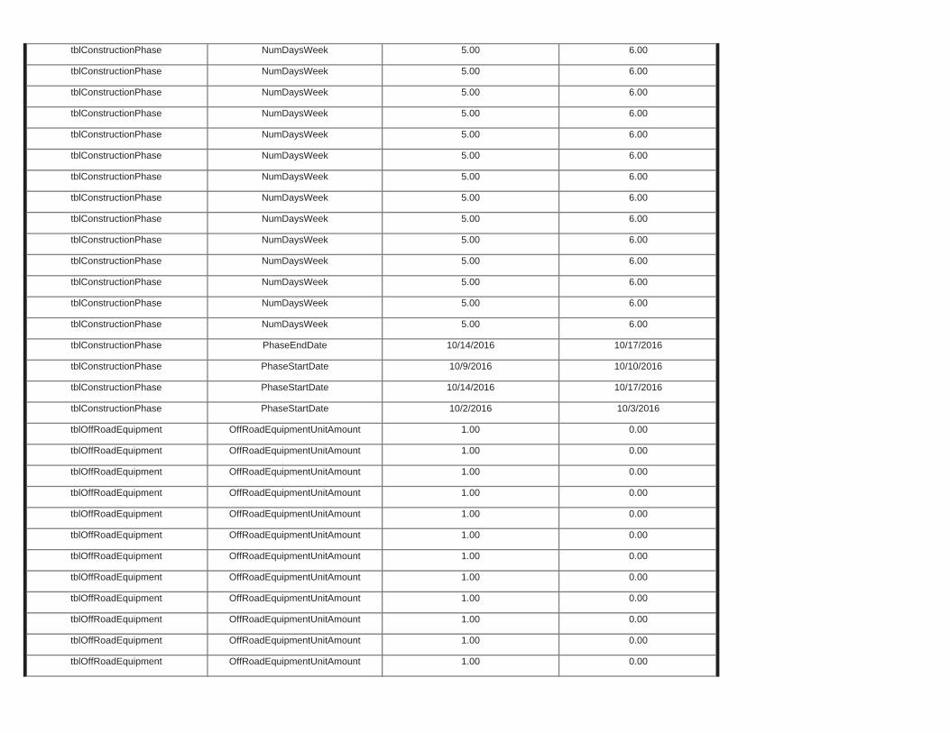
tblOffRoadEquipment OffRoadEquipmentUnitAmount 1.00 0.00
tblOffRoadEquipment OffRoadEquipmentUnitAmount 1.00 0.00
tblOffRoadEquipment OffRoadEquipmentUnitAmount 1.00 0.00
tblOffRoadEquipment OffRoadEquipmentUnitAmount 1.00 0.00
tblOffRoadEquipment OffRoadEquipmentUnitAmount 1.00 0.00
tblOffRoadEquipment OffRoadEquipmentUnitAmount 1.00 0.00
tblOffRoadEquipment OffRoadEquipmentUnitAmount 1.00 0.00
tblOffRoadEquipment OffRoadEquipmentUnitAmount 1.00 0.00
tblOffRoadEquipment OffRoadEquipmentUnitAmount 1.00 0.00
tblOffRoadEquipment OffRoadEquipmentUnitAmount 1.00 0.00
tblOffRoadEquipment OffRoadEquipmentUnitAmount 1.00 0.00
tblOffRoadEquipment OffRoadEquipmentUnitAmount 1.00 0.00
tblConstructionPhase PhaseStartDate 10/14/2016 10/17/2016
tblConstructionPhase PhaseStartDate 10/2/2016 10/3/2016
tblConstructionPhase PhaseEndDate 10/14/2016 10/17/2016
tblConstructionPhase PhaseStartDate 10/9/2016 10/10/2016
tblConstructionPhase NumDaysWeek 5.00 6.00
tblConstructionPhase NumDaysWeek 5.00 6.00
tblConstructionPhase NumDaysWeek 5.00 6.00
tblConstructionPhase NumDaysWeek 5.00 6.00
tblConstructionPhase NumDaysWeek 5.00 6.00
tblConstructionPhase NumDaysWeek 5.00 6.00
tblConstructionPhase NumDaysWeek 5.00 6.00
tblConstructionPhase NumDaysWeek 5.00 6.00
tblConstructionPhase NumDaysWeek 5.00 6.00
tblConstructionPhase NumDaysWeek 5.00 6.00
tblConstructionPhase NumDaysWeek 5.00 6.00
tblConstructionPhase NumDaysWeek 5.00 6.00
tblConstructionPhase NumDaysWeek 5.00 6.00
tblConstructionPhase NumDaysWeek 5.00 6.00
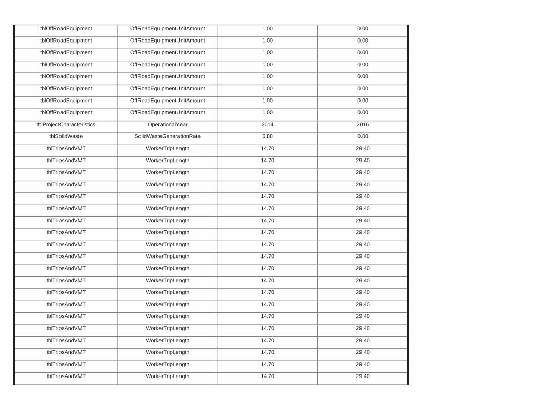
tblTripsAndVMT WorkerTripLength 14.70 29.40
tblTripsAndVMT WorkerTripLength 14.70 29.40
tblTripsAndVMT WorkerTripLength 14.70 29.40
tblTripsAndVMT WorkerTripLength 14.70 29.40
tblTripsAndVMT WorkerTripLength 14.70 29.40
tblTripsAndVMT WorkerTripLength 14.70 29.40
tblTripsAndVMT WorkerTripLength 14.70 29.40
tblTripsAndVMT WorkerTripLength 14.70 29.40
tblTripsAndVMT WorkerTripLength 14.70 29.40
tblTripsAndVMT WorkerTripLength 14.70 29.40
tblTripsAndVMT WorkerTripLength 14.70 29.40
tblTripsAndVMT WorkerTripLength 14.70 29.40
tblTripsAndVMT WorkerTripLength 14.70 29.40
tblTripsAndVMT WorkerTripLength 14.70 29.40
tblTripsAndVMT WorkerTripLength 14.70 29.40
tblTripsAndVMT WorkerTripLength 14.70 29.40
tblTripsAndVMT WorkerTripLength 14.70 29.40
tblTripsAndVMT WorkerTripLength 14.70 29.40
tblTripsAndVMT WorkerTripLength 14.70 29.40
tblTripsAndVMT WorkerTripLength 14.70 29.40
tblProjectCharacteristics OperationalYear 2014 2016
tblSolidWaste SolidWasteGenerationRate 6.88 0.00
tblOffRoadEquipment OffRoadEquipmentUnitAmount 1.00 0.00
tblOffRoadEquipment OffRoadEquipmentUnitAmount 1.00 0.00
tblOffRoadEquipment OffRoadEquipmentUnitAmount 1.00 0.00
tblOffRoadEquipment OffRoadEquipmentUnitAmount 1.00 0.00
tblOffRoadEquipment OffRoadEquipmentUnitAmount 1.00 0.00
tblOffRoadEquipment OffRoadEquipmentUnitAmount 1.00 0.00
tblOffRoadEquipment OffRoadEquipmentUnitAmount 1.00 0.00
tblOffRoadEquipment OffRoadEquipmentUnitAmount 1.00 0.00
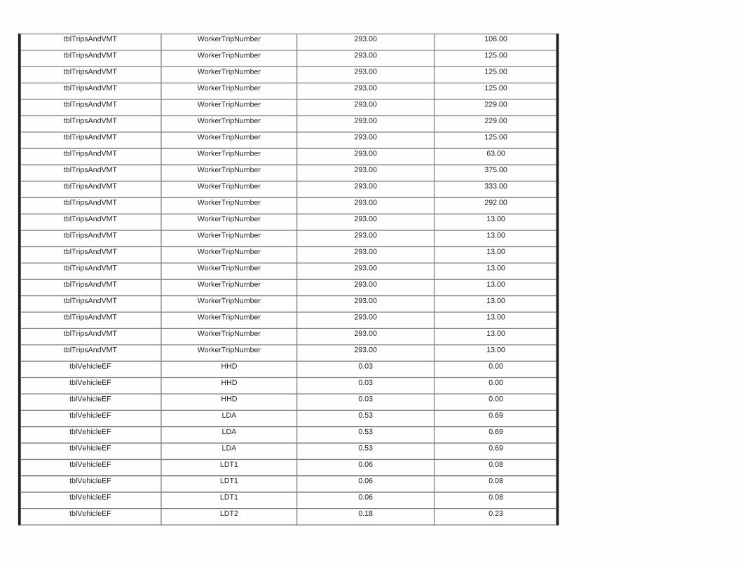
tblVehicleEF LDT1 0.06 0.08
tblVehicleEF LDT2 0.18 0.23
tblVehicleEF LDT1 0.06 0.08
tblVehicleEF LDT1 0.06 0.08
tblVehicleEF LDA 0.53 0.69
tblVehicleEF LDA 0.53 0.69
tblVehicleEF HHD 0.03 0.00
tblVehicleEF LDA 0.53 0.69
tblVehicleEF HHD 0.03 0.00
tblVehicleEF HHD 0.03 0.00
tblTripsAndVMT WorkerTripNumber 293.00 13.00
tblTripsAndVMT WorkerTripNumber 293.00 13.00
tblTripsAndVMT WorkerTripNumber 293.00 13.00
tblTripsAndVMT WorkerTripNumber 293.00 13.00
tblTripsAndVMT WorkerTripNumber 293.00 13.00
tblTripsAndVMT WorkerTripNumber 293.00 13.00
tblTripsAndVMT WorkerTripNumber 293.00 13.00
tblTripsAndVMT WorkerTripNumber 293.00 13.00
tblTripsAndVMT WorkerTripNumber 293.00 292.00
tblTripsAndVMT WorkerTripNumber 293.00 13.00
tblTripsAndVMT WorkerTripNumber 293.00 375.00
tblTripsAndVMT WorkerTripNumber 293.00 333.00
tblTripsAndVMT WorkerTripNumber 293.00 125.00
tblTripsAndVMT WorkerTripNumber 293.00 63.00
tblTripsAndVMT WorkerTripNumber 293.00 229.00
tblTripsAndVMT WorkerTripNumber 293.00 229.00
tblTripsAndVMT WorkerTripNumber 293.00 125.00
tblTripsAndVMT WorkerTripNumber 293.00 125.00
tblTripsAndVMT WorkerTripNumber 293.00 108.00
tblTripsAndVMT WorkerTripNumber 293.00 125.00
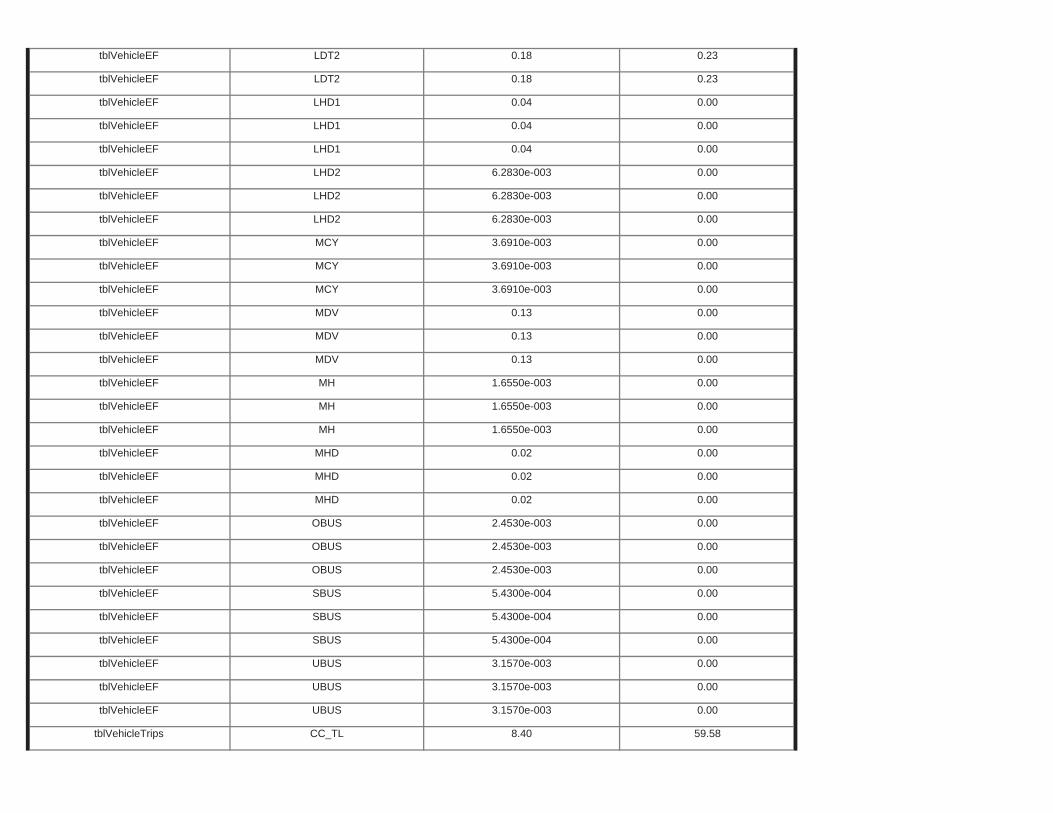
tblVehicleEF UBUS 3.1570e-003 0.00
tblVehicleTrips CC_TL 8.40 59.58
tblVehicleEF UBUS 3.1570e-003 0.00
tblVehicleEF UBUS 3.1570e-003 0.00
tblVehicleEF SBUS 5.4300e-004 0.00
tblVehicleEF SBUS 5.4300e-004 0.00
tblVehicleEF OBUS 2.4530e-003 0.00
tblVehicleEF SBUS 5.4300e-004 0.00
tblVehicleEF OBUS 2.4530e-003 0.00
tblVehicleEF OBUS 2.4530e-003 0.00
tblVehicleEF MHD 0.02 0.00
tblVehicleEF MHD 0.02 0.00
tblVehicleEF MH 1.6550e-003 0.00
tblVehicleEF MHD 0.02 0.00
tblVehicleEF MH 1.6550e-003 0.00
tblVehicleEF MH 1.6550e-003 0.00
tblVehicleEF MDV 0.13 0.00
tblVehicleEF MDV 0.13 0.00
tblVehicleEF MCY 3.6910e-003 0.00
tblVehicleEF MDV 0.13 0.00
tblVehicleEF MCY 3.6910e-003 0.00
tblVehicleEF MCY 3.6910e-003 0.00
tblVehicleEF LHD2 6.2830e-003 0.00
tblVehicleEF LHD2 6.2830e-003 0.00
tblVehicleEF LHD1 0.04 0.00
tblVehicleEF LHD2 6.2830e-003 0.00
tblVehicleEF LHD1 0.04 0.00
tblVehicleEF LHD1 0.04 0.00
tblVehicleEF LDT2 0.18 0.23
tblVehicleEF LDT2 0.18 0.23
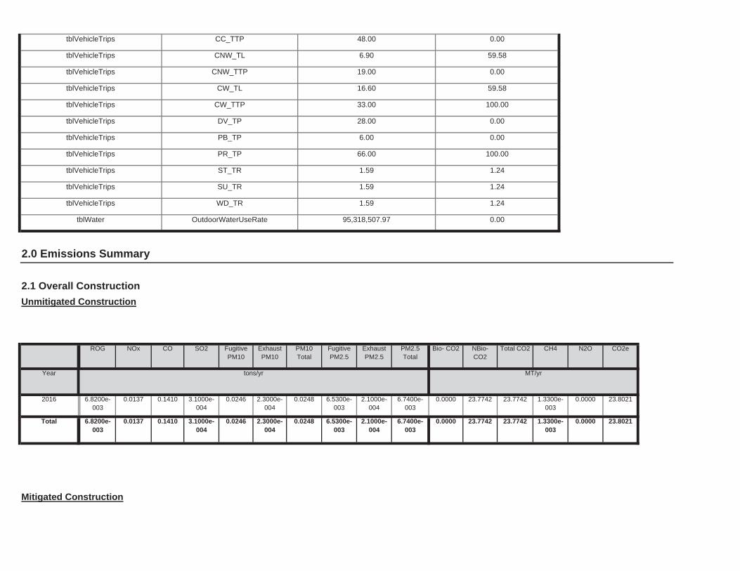
Mitigated Construction
0.0000 23.7742 23.7742 1.3300e-003
0.0000 23.80210.0246 2.3000e-004
0.0248 6.5300e-003
2.1000e-004
6.7400e-003
Total 6.8200e-003
0.0137 0.1410 3.1000e-004
0.0000 23.7742 23.7742 1.3300e-003
0.0000 23.80210.0246 2.3000e-004
0.0248 6.5300e-003
2.1000e-004
6.7400e-003
2016 6.8200e-003
0.0137 0.1410 3.1000e-004
NBio-CO2
Total CO2 CH4 N2O CO2e
Year tons/yr MT/yr
ExhaustPM10
PM10Total
FugitivePM2.5
ExhaustPM2.5
PM2.5Total
Bio- CO2
2.0 Emissions Summary
2.1 Overall Construction
Unmitigated Construction
ROG NOx CO SO2 Fugitive PM10
tblVehicleTrips WD_TR 1.59 1.24
tblWater OutdoorWaterUseRate 95,318,507.97 0.00
tblVehicleTrips ST_TR 1.59 1.24
tblVehicleTrips SU_TR 1.59 1.24
tblVehicleTrips PB_TP 6.00 0.00
tblVehicleTrips PR_TP 66.00 100.00
tblVehicleTrips CW_TTP 33.00 100.00
tblVehicleTrips DV_TP 28.00 0.00
tblVehicleTrips CNW_TTP 19.00 0.00
tblVehicleTrips CW_TL 16.60 59.58
tblVehicleTrips CC_TTP 48.00 0.00
tblVehicleTrips CNW_TL 6.90 59.58
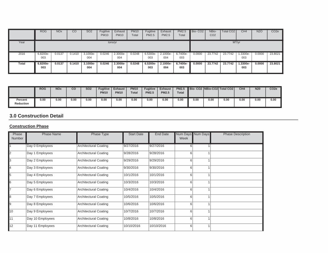
1
12 Day 11 Employees Architectural Coating 10/10/2016 10/10/2016 6 1
11 Day 10 Employees Architectural Coating 10/8/2016 10/8/2016 6
1
10 Day 9 Employees Architectural Coating 10/7/2016 10/7/2016 6 1
9 Day 8 Employees Architectural Coating 10/6/2016 10/6/2016 6
1
8 Day 7 Employees Architectural Coating 10/5/2016 10/5/2016 6 1
7 Day 6 Employees Architectural Coating 10/4/2016 10/4/2016 6
1
6 Day 5 Employees Architectural Coating 10/3/2016 10/3/2016 6 1
5 Day 4 Employees Architectural Coating 10/1/2016 10/1/2016 6
1
4 Day 3 Employees Architectural Coating 9/30/2016 9/30/2016 6 1
3 Day 2 Employees Architectural Coating 9/29/2016 9/29/2016 6
1
2 Day 1 Employees Architectural Coating 9/28/2016 9/28/2016 6 1
End Date Num Days Week
Num Days Phase Description
1 Day 0 Employees Architectural Coating 9/27/2016 9/27/2016 6
3.0 Construction Detail
Construction Phase
PhaseNumber
Phase Name Phase Type Start Date
0.00 0.00 0.00 0.00 0.00 0.000.00 0.00 0.00 0.00 0.00 0.00
NBio-CO2 Total CO2 CH4 N20 CO2e
PercentReduction
0.00 0.00 0.00 0.00
ExhaustPM10
PM10Total
FugitivePM2.5
ExhaustPM2.5
PM2.5Total
Bio- CO2ROG NOx CO SO2 Fugitive PM10
0.0000 23.7742 23.7742 1.3300e-003
0.0000 23.80210.0246 2.3000e-004
0.0248 6.5300e-003
2.1000e-004
6.7400e-003
Total 6.8200e-003
0.0137 0.1410 3.1000e-004
0.0000 23.7742 23.7742 1.3300e-003
0.0000 23.80210.0246 2.3000e-004
0.0248 6.5300e-003
2.1000e-004
6.7400e-003
2016 6.8200e-003
0.0137 0.1410 3.1000e-004
Total CO2 CH4 N2O CO2e
Year tons/yr MT/yr
PM10Total
FugitivePM2.5
ExhaustPM2.5
PM2.5Total
Bio- CO2 NBio- CO2
ROG NOx CO SO2 Fugitive PM10
ExhaustPM10
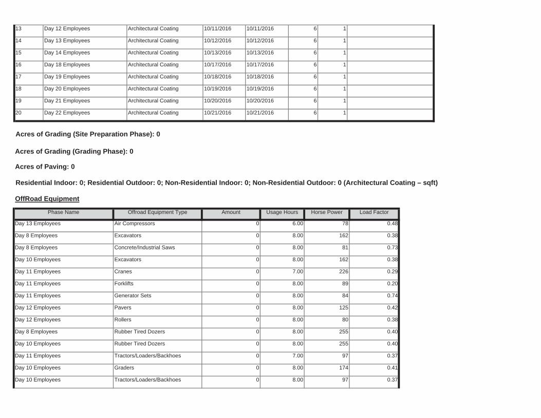
Day 10 Employees Tractors/Loaders/Backhoes 0 8.00 97 0.37
Day 10 Employees Graders 0 8.00 174 0.41
Day 11 Employees Tractors/Loaders/Backhoes 0 7.00 97 0.37
Day 10 Employees Rubber Tired Dozers 0 8.00 255 0.40
Day 8 Employees Rubber Tired Dozers 0 8.00 255 0.40
Day 12 Employees Rollers 0 8.00 80 0.38
Day 12 Employees Pavers 0 8.00 125 0.42
Day 11 Employees Generator Sets 0 8.00 84 0.74
Day 11 Employees Forklifts 0 8.00 89 0.20
Day 11 Employees Cranes 0 7.00 226 0.29
Day 10 Employees Excavators 0 8.00 162 0.38
Day 8 Employees Concrete/Industrial Saws 0 8.00 81 0.73
Day 8 Employees Excavators 0 8.00 162 0.38
Load Factor
Day 13 Employees Air Compressors 0 6.00 78 0.48
Acres of Grading (Site Preparation Phase): 0
Acres of Grading (Grading Phase): 0
Acres of Paving: 0
Residential Indoor: 0; Residential Outdoor: 0; Non-Residential Indoor: 0; Non-Residential Outdoor: 0 (Architectural Coating – sqft)
OffRoad Equipment
Phase Name Offroad Equipment Type Amount Usage Hours Horse Power
1
20 Day 22 Employees Architectural Coating 10/21/2016 10/21/2016 6 1
19 Day 21 Employees Architectural Coating 10/20/2016 10/20/2016 6
1
18 Day 20 Employees Architectural Coating 10/19/2016 10/19/2016 6 1
17 Day 19 Employees Architectural Coating 10/18/2016 10/18/2016 6
1
16 Day 18 Employees Architectural Coating 10/17/2016 10/17/2016 6 1
15 Day 14 Employees Architectural Coating 10/13/2016 10/13/2016 6
1
14 Day 13 Employees Architectural Coating 10/12/2016 10/12/2016 6 1
13 Day 12 Employees Architectural Coating 10/11/2016 10/11/2016 6
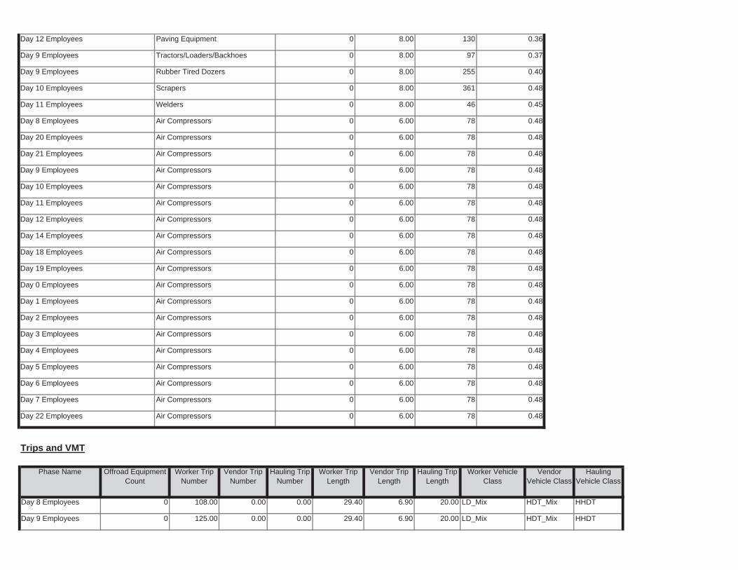
29.40 6.90 20.00 LD_Mix HDT_Mix HHDT
6.90 20.00 LD_Mix HDT_Mix HHDT
Day 9 Employees 0 125.00 0.00 0.00
Day 8 Employees 0 108.00 0.00 0.00 29.40
Worker Trip Length
Vendor Trip Length
Hauling Trip Length
Worker Vehicle Class
VendorVehicle Class
HaulingVehicle Class
Trips and VMT
Phase Name Offroad Equipment Count
Worker Trip Number
Vendor Trip Number
Hauling Trip Number
Day 22 Employees Air Compressors 0 6.00 78 0.48
Day 7 Employees Air Compressors 0 6.00 78 0.48
Day 6 Employees Air Compressors 0 6.00 78 0.48
Day 5 Employees Air Compressors 0 6.00 78 0.48
Day 4 Employees Air Compressors 0 6.00 78 0.48
Day 3 Employees Air Compressors 0 6.00 78 0.48
Day 2 Employees Air Compressors 0 6.00 78 0.48
Day 1 Employees Air Compressors 0 6.00 78 0.48
Day 0 Employees Air Compressors 0 6.00 78 0.48
Day 19 Employees Air Compressors 0 6.00 78 0.48
Day 18 Employees Air Compressors 0 6.00 78 0.48
Day 14 Employees Air Compressors 0 6.00 78 0.48
Day 12 Employees Air Compressors 0 6.00 78 0.48
Day 11 Employees Air Compressors 0 6.00 78 0.48
Day 10 Employees Air Compressors 0 6.00 78 0.48
Day 9 Employees Air Compressors 0 6.00 78 0.48
Day 21 Employees Air Compressors 0 6.00 78 0.48
Day 20 Employees Air Compressors 0 6.00 78 0.48
Day 8 Employees Air Compressors 0 6.00 78 0.48
Day 11 Employees Welders 0 8.00 46 0.45
Day 10 Employees Scrapers 0 8.00 361 0.48
Day 9 Employees Rubber Tired Dozers 0 8.00 255 0.40
Day 9 Employees Tractors/Loaders/Backhoes 0 8.00 97 0.37
Day 12 Employees Paving Equipment 0 8.00 130 0.36
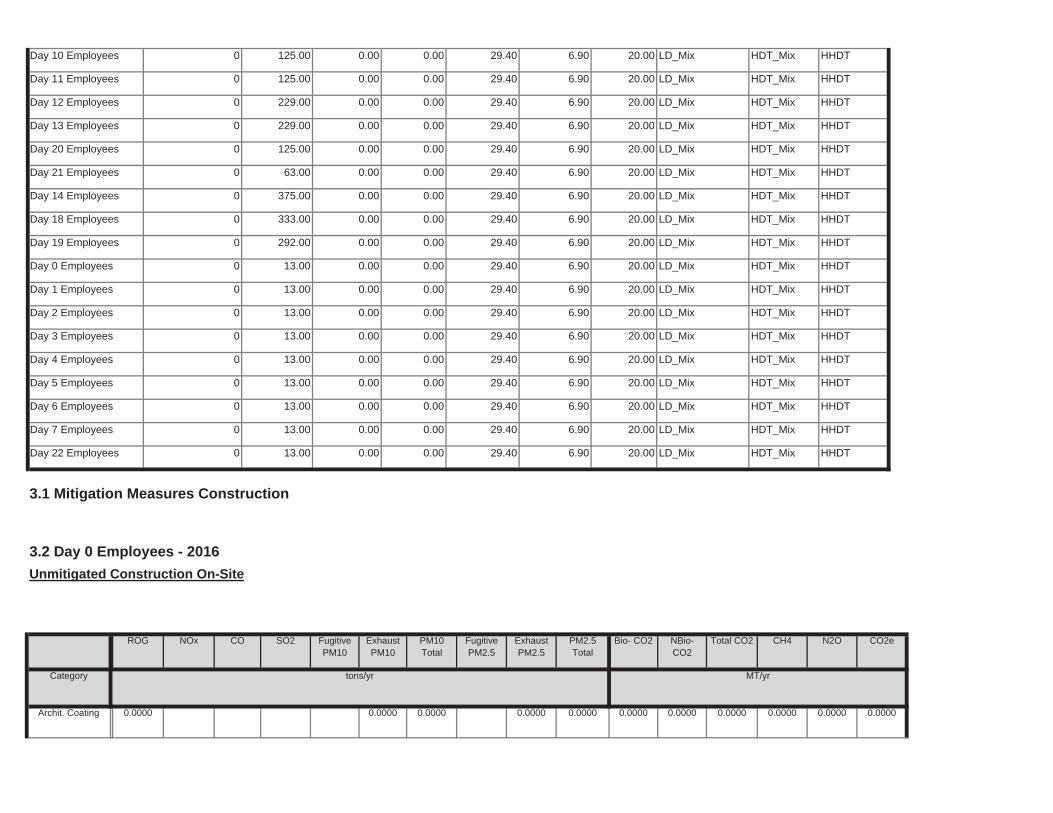
0.0000 0.0000 0.0000 0.0000 0.0000 0.00000.0000 0.0000 0.0000 0.0000Archit. Coating 0.0000
NBio-CO2
Total CO2 CH4 N2O CO2e
Category tons/yr MT/yr
ExhaustPM10
PM10Total
FugitivePM2.5
ExhaustPM2.5
PM2.5Total
Bio- CO2
3.1 Mitigation Measures Construction
3.2 Day 0 Employees - 2016
Unmitigated Construction On-Site
ROG NOx CO SO2 Fugitive PM10
29.40 6.90 20.00 LD_Mix HDT_Mix HHDT
6.90 20.00 LD_Mix HDT_Mix HHDT
Day 22 Employees 0 13.00 0.00 0.00
Day 7 Employees 0 13.00 0.00 0.00 29.40
29.40 6.90 20.00 LD_Mix HDT_Mix HHDT
6.90 20.00 LD_Mix HDT_Mix HHDT
Day 6 Employees 0 13.00 0.00 0.00
Day 5 Employees 0 13.00 0.00 0.00 29.40
29.40 6.90 20.00 LD_Mix HDT_Mix HHDT
6.90 20.00 LD_Mix HDT_Mix HHDT
Day 4 Employees 0 13.00 0.00 0.00
Day 3 Employees 0 13.00 0.00 0.00 29.40
29.40 6.90 20.00 LD_Mix HDT_Mix HHDT
6.90 20.00 LD_Mix HDT_Mix HHDT
Day 2 Employees 0 13.00 0.00 0.00
Day 1 Employees 0 13.00 0.00 0.00 29.40
29.40 6.90 20.00 LD_Mix HDT_Mix HHDT
6.90 20.00 LD_Mix HDT_Mix HHDT
Day 0 Employees 0 13.00 0.00 0.00
Day 19 Employees 0 292.00 0.00 0.00 29.40
29.40 6.90 20.00 LD_Mix HDT_Mix HHDT
6.90 20.00 LD_Mix HDT_Mix HHDT
Day 18 Employees 0 333.00 0.00 0.00
Day 14 Employees 0 375.00 0.00 0.00 29.40
29.40 6.90 20.00 LD_Mix HDT_Mix HHDT
6.90 20.00 LD_Mix HDT_Mix HHDT
Day 21 Employees 0 63.00 0.00 0.00
Day 20 Employees 0 125.00 0.00 0.00 29.40
29.40 6.90 20.00 LD_Mix HDT_Mix HHDT
6.90 20.00 LD_Mix HDT_Mix HHDT
Day 13 Employees 0 229.00 0.00 0.00
Day 12 Employees 0 229.00 0.00 0.00 29.40
29.40 6.90 20.00 LD_Mix HDT_Mix HHDT
6.90 20.00 LD_Mix HDT_Mix HHDT
Day 11 Employees 0 125.00 0.00 0.00
Day 10 Employees 0 125.00 0.00 0.00 29.40
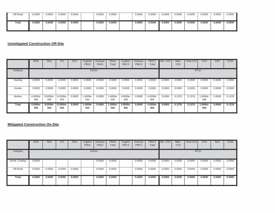
0.0000 0.0000 0.0000 0.0000 0.0000 0.00000.0000 0.0000 0.0000 0.0000Total 0.0000 0.0000 0.0000 0.0000
0.0000 0.0000 0.0000 0.0000 0.0000 0.00000.0000 0.0000 0.0000 0.0000Off-Road 0.0000 0.0000 0.0000 0.0000
0.0000 0.0000 0.0000 0.0000 0.0000 0.00000.0000 0.0000 0.0000 0.0000Archit. Coating 0.0000
Total CO2 CH4 N2O CO2e
Category tons/yr MT/yr
PM10Total
FugitivePM2.5
ExhaustPM2.5
PM2.5Total
Bio- CO2 NBio- CO2
Mitigated Construction On-Site
ROG NOx CO SO2 Fugitive PM10
ExhaustPM10
0.0000 0.1376 0.1376 1.0000e-005
0.0000 0.13781.4000e-004
0.0000 1.4000e-004
4.0000e-005
0.0000 4.0000e-005
Total 4.0000e-005
8.0000e-005
8.2000e-004
0.0000
0.0000 0.1376 0.1376 1.0000e-005
0.0000 0.13781.4000e-004
0.0000 1.4000e-004
4.0000e-005
0.0000 4.0000e-005
Worker 4.0000e-005
8.0000e-005
8.2000e-004
0.0000
0.0000 0.0000 0.0000 0.0000 0.0000 0.00000.0000 0.0000 0.0000 0.0000 0.0000 0.0000Vendor 0.0000 0.0000 0.0000 0.0000
0.0000 0.0000 0.0000 0.0000 0.0000 0.00000.0000 0.0000 0.0000 0.0000 0.0000 0.0000Hauling 0.0000 0.0000 0.0000 0.0000
Total CO2 CH4 N2O CO2e
Category tons/yr MT/yr
PM10Total
FugitivePM2.5
ExhaustPM2.5
PM2.5Total
Bio- CO2 NBio- CO2
Unmitigated Construction Off-Site
ROG NOx CO SO2 Fugitive PM10
ExhaustPM10
0.0000 0.0000 0.0000 0.0000 0.0000 0.00000.0000 0.0000 0.0000 0.0000Total 0.0000 0.0000 0.0000 0.0000
0.0000 0.0000 0.0000 0.0000 0.0000 0.00000.0000 0.0000 0.0000 0.0000Off-Road 0.0000 0.0000 0.0000 0.0000
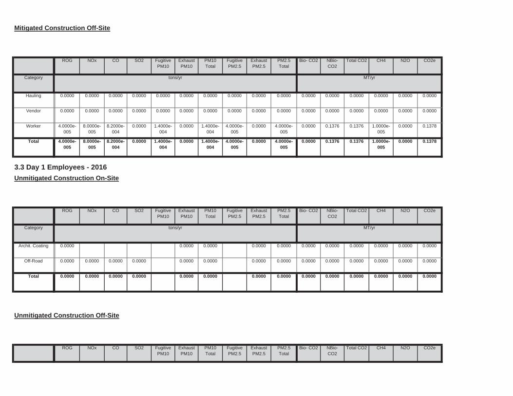
Total CO2 CH4 N2O CO2ePM10Total
FugitivePM2.5
ExhaustPM2.5
PM2.5Total
Bio- CO2 NBio- CO2
Unmitigated Construction Off-Site
ROG NOx CO SO2 Fugitive PM10
ExhaustPM10
0.0000 0.0000 0.0000 0.0000 0.0000 0.00000.0000 0.0000 0.0000 0.0000Total 0.0000 0.0000 0.0000 0.0000
0.0000 0.0000 0.0000 0.0000 0.0000 0.00000.0000 0.0000 0.0000 0.0000Off-Road 0.0000 0.0000 0.0000 0.0000
0.0000 0.0000 0.0000 0.0000 0.0000 0.00000.0000 0.0000 0.0000 0.0000Archit. Coating 0.0000
Total CO2 CH4 N2O CO2e
Category tons/yr MT/yr
PM10Total
FugitivePM2.5
ExhaustPM2.5
PM2.5Total
Bio- CO2 NBio- CO2
3.3 Day 1 Employees - 2016
Unmitigated Construction On-Site
ROG NOx CO SO2 Fugitive PM10
ExhaustPM10
0.0000 0.1376 0.1376 1.0000e-005
0.0000 0.13781.4000e-004
0.0000 1.4000e-004
4.0000e-005
0.0000 4.0000e-005
Total 4.0000e-005
8.0000e-005
8.2000e-004
0.0000
0.0000 0.1376 0.1376 1.0000e-005
0.0000 0.13781.4000e-004
0.0000 1.4000e-004
4.0000e-005
0.0000 4.0000e-005
Worker 4.0000e-005
8.0000e-005
8.2000e-004
0.0000
0.0000 0.0000 0.0000 0.0000 0.0000 0.00000.0000 0.0000 0.0000 0.0000 0.0000 0.0000Vendor 0.0000 0.0000 0.0000 0.0000
0.0000 0.0000 0.0000 0.0000 0.0000 0.00000.0000 0.0000 0.0000 0.0000 0.0000 0.0000Hauling 0.0000 0.0000 0.0000 0.0000
Total CO2 CH4 N2O CO2e
Category tons/yr MT/yr
PM10Total
FugitivePM2.5
ExhaustPM2.5
PM2.5Total
Bio- CO2 NBio- CO2
Mitigated Construction Off-Site
ROG NOx CO SO2 Fugitive PM10
ExhaustPM10
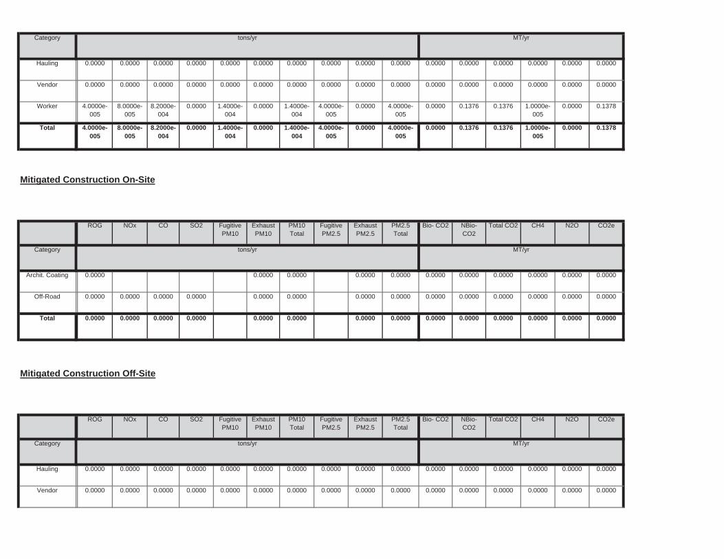
0.0000 0.0000 0.0000 0.0000 0.0000 0.00000.0000 0.0000 0.0000 0.0000Total 0.0000 0.0000 0.0000 0.0000
0.0000 0.0000 0.0000 0.0000 0.0000 0.00000.0000 0.0000 0.0000 0.0000Off-Road 0.0000 0.0000 0.0000 0.0000
0.0000 0.0000 0.0000 0.0000 0.0000 0.00000.0000 0.0000 0.0000 0.0000Archit. Coating 0.0000
Total CO2 CH4 N2O CO2e
Category tons/yr MT/yr
PM10Total
FugitivePM2.5
ExhaustPM2.5
PM2.5Total
Bio- CO2 NBio- CO2
Mitigated Construction On-Site
ROG NOx CO SO2 Fugitive PM10
ExhaustPM10
0.0000 0.1376 0.1376 1.0000e-005
0.0000 0.13781.4000e-004
0.0000 1.4000e-004
4.0000e-005
0.0000 4.0000e-005
Total 4.0000e-005
8.0000e-005
8.2000e-004
0.0000
0.0000 0.1376 0.1376 1.0000e-005
0.0000 0.13781.4000e-004
0.0000 1.4000e-004
4.0000e-005
0.0000 4.0000e-005
Worker 4.0000e-005
8.0000e-005
8.2000e-004
0.0000
0.0000 0.0000 0.0000 0.0000 0.0000 0.00000.0000 0.0000 0.0000 0.0000 0.0000 0.0000Vendor 0.0000 0.0000 0.0000 0.0000
0.0000 0.0000 0.0000 0.0000 0.0000 0.00000.0000 0.0000 0.0000 0.0000 0.0000 0.0000Hauling 0.0000 0.0000 0.0000 0.0000
Category tons/yr MT/yr
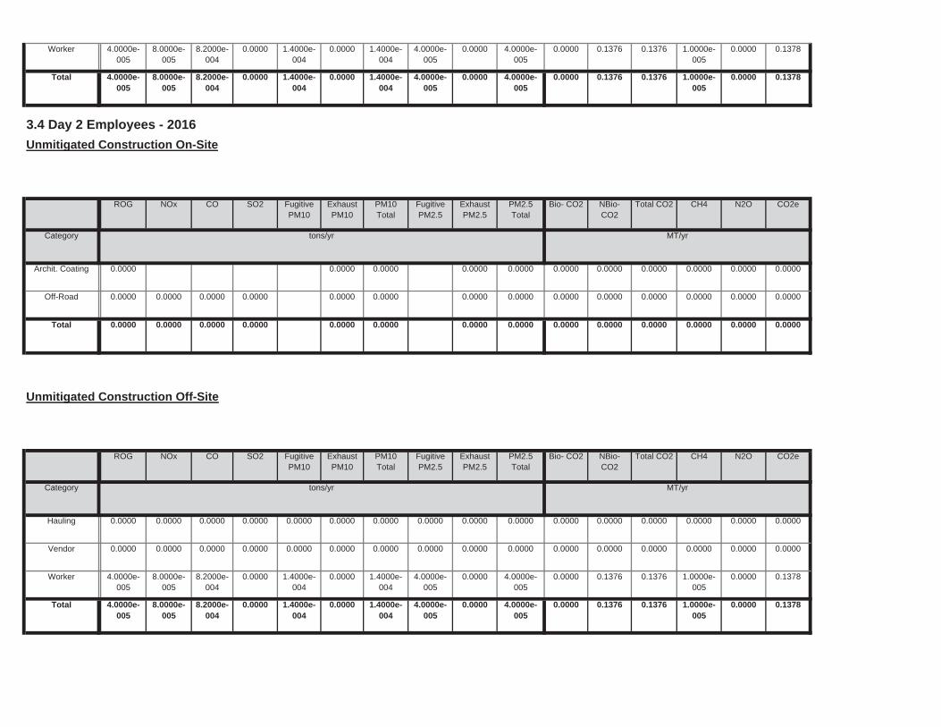
0.0000 0.1376 0.1376 1.0000e-005
0.0000 0.13781.4000e-004
0.0000 1.4000e-004
4.0000e-005
0.0000 4.0000e-005
Total 4.0000e-005
8.0000e-005
8.2000e-004
0.0000
0.0000 0.1376 0.1376 1.0000e-005
0.0000 0.13781.4000e-004
0.0000 1.4000e-004
4.0000e-005
0.0000 4.0000e-005
Worker 4.0000e-005
8.0000e-005
8.2000e-004
0.0000
0.0000 0.0000 0.0000 0.0000 0.0000 0.00000.0000 0.0000 0.0000 0.0000 0.0000 0.0000Vendor 0.0000 0.0000 0.0000 0.0000
0.0000 0.0000 0.0000 0.0000 0.0000 0.00000.0000 0.0000 0.0000 0.0000 0.0000 0.0000Hauling 0.0000 0.0000 0.0000 0.0000
Total CO2 CH4 N2O CO2e
Category tons/yr MT/yr
PM10Total
FugitivePM2.5
ExhaustPM2.5
PM2.5Total
Bio- CO2 NBio- CO2
Unmitigated Construction Off-Site
ROG NOx CO SO2 Fugitive PM10
ExhaustPM10
0.0000 0.0000 0.0000 0.0000 0.0000 0.00000.0000 0.0000 0.0000 0.0000Total 0.0000 0.0000 0.0000 0.0000
0.0000 0.0000 0.0000 0.0000 0.0000 0.00000.0000 0.0000 0.0000 0.0000Off-Road 0.0000 0.0000 0.0000 0.0000
0.0000 0.0000 0.0000 0.0000 0.0000 0.00000.0000 0.0000 0.0000 0.0000Archit. Coating 0.0000
Total CO2 CH4 N2O CO2e
Category tons/yr MT/yr
PM10Total
FugitivePM2.5
ExhaustPM2.5
PM2.5Total
Bio- CO2 NBio- CO2
3.4 Day 2 Employees - 2016
Unmitigated Construction On-Site
ROG NOx CO SO2 Fugitive PM10
ExhaustPM10
0.0000 0.1376 0.1376 1.0000e-005
0.0000 0.13781.4000e-004
0.0000 1.4000e-004
4.0000e-005
0.0000 4.0000e-005
Total 4.0000e-005
8.0000e-005
8.2000e-004
0.0000
0.0000 0.1376 0.1376 1.0000e-005
0.0000 0.13781.4000e-004
0.0000 1.4000e-004
4.0000e-005
0.0000 4.0000e-005
Worker 4.0000e-005
8.0000e-005
8.2000e-004
0.0000

Total CO2 CH4 N2O CO2ePM10Total
FugitivePM2.5
ExhaustPM2.5
PM2.5Total
Bio- CO2 NBio- CO2
3.5 Day 3 Employees - 2016
Unmitigated Construction On-Site
ROG NOx CO SO2 Fugitive PM10
ExhaustPM10
0.0000 0.1376 0.1376 1.0000e-005
0.0000 0.13781.4000e-004
0.0000 1.4000e-004
4.0000e-005
0.0000 4.0000e-005
Total 4.0000e-005
8.0000e-005
8.2000e-004
0.0000
0.0000 0.1376 0.1376 1.0000e-005
0.0000 0.13781.4000e-004
0.0000 1.4000e-004
4.0000e-005
0.0000 4.0000e-005
Worker 4.0000e-005
8.0000e-005
8.2000e-004
0.0000
0.0000 0.0000 0.0000 0.0000 0.0000 0.00000.0000 0.0000 0.0000 0.0000 0.0000 0.0000Vendor 0.0000 0.0000 0.0000 0.0000
0.0000 0.0000 0.0000 0.0000 0.0000 0.00000.0000 0.0000 0.0000 0.0000 0.0000 0.0000Hauling 0.0000 0.0000 0.0000 0.0000
Total CO2 CH4 N2O CO2e
Category tons/yr MT/yr
PM10Total
FugitivePM2.5
ExhaustPM2.5
PM2.5Total
Bio- CO2 NBio- CO2
Mitigated Construction Off-Site
ROG NOx CO SO2 Fugitive PM10
ExhaustPM10
0.0000 0.0000 0.0000 0.0000 0.0000 0.00000.0000 0.0000 0.0000 0.0000Total 0.0000 0.0000 0.0000 0.0000
0.0000 0.0000 0.0000 0.0000 0.0000 0.00000.0000 0.0000 0.0000 0.0000Off-Road 0.0000 0.0000 0.0000 0.0000
0.0000 0.0000 0.0000 0.0000 0.0000 0.00000.0000 0.0000 0.0000 0.0000Archit. Coating 0.0000
Total CO2 CH4 N2O CO2e
Category tons/yr MT/yr
PM10Total
FugitivePM2.5
ExhaustPM2.5
PM2.5Total
Bio- CO2 NBio- CO2
Mitigated Construction On-Site
ROG NOx CO SO2 Fugitive PM10
ExhaustPM10
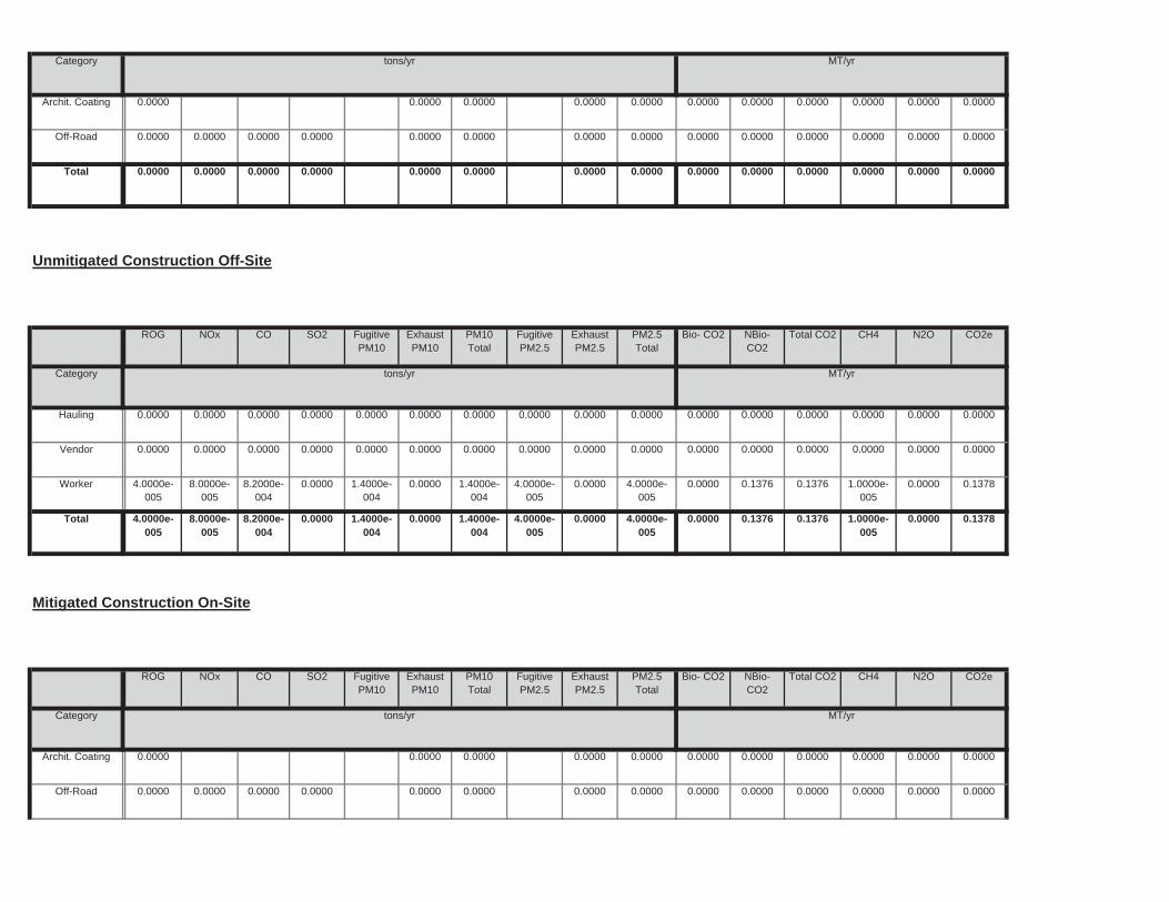
0.0000 0.1376 0.1376 1.0000e-005
0.0000 0.13781.4000e-004
0.0000 1.4000e-004
4.0000e-005
0.0000 4.0000e-005
Total 4.0000e-005
8.0000e-005
8.2000e-004
0.0000
0.0000 0.1376 0.1376 1.0000e-005
0.0000 0.13781.4000e-004
0.0000 1.4000e-004
4.0000e-005
0.0000 4.0000e-005
Worker 4.0000e-005
8.0000e-005
8.2000e-004
0.0000
0.0000 0.0000 0.0000 0.0000 0.0000 0.00000.0000 0.0000 0.0000 0.0000 0.0000 0.0000Vendor 0.0000 0.0000 0.0000 0.0000
0.0000 0.0000 0.0000 0.0000 0.0000 0.00000.0000 0.0000 0.0000 0.0000 0.0000 0.0000Hauling 0.0000 0.0000 0.0000 0.0000
Total CO2 CH4 N2O CO2e
Category tons/yr MT/yr
PM10Total
FugitivePM2.5
ExhaustPM2.5
PM2.5Total
Bio- CO2 NBio- CO2
Unmitigated Construction Off-Site
ROG NOx CO SO2 Fugitive PM10
ExhaustPM10
0.0000 0.0000 0.0000 0.0000 0.0000 0.00000.0000 0.0000 0.0000 0.0000Total 0.0000 0.0000 0.0000 0.0000
0.0000 0.0000 0.0000 0.0000 0.0000 0.00000.0000 0.0000 0.0000 0.0000Off-Road 0.0000 0.0000 0.0000 0.0000
0.0000 0.0000 0.0000 0.0000 0.0000 0.00000.0000 0.0000 0.0000 0.0000Archit. Coating 0.0000
Category tons/yr MT/yr
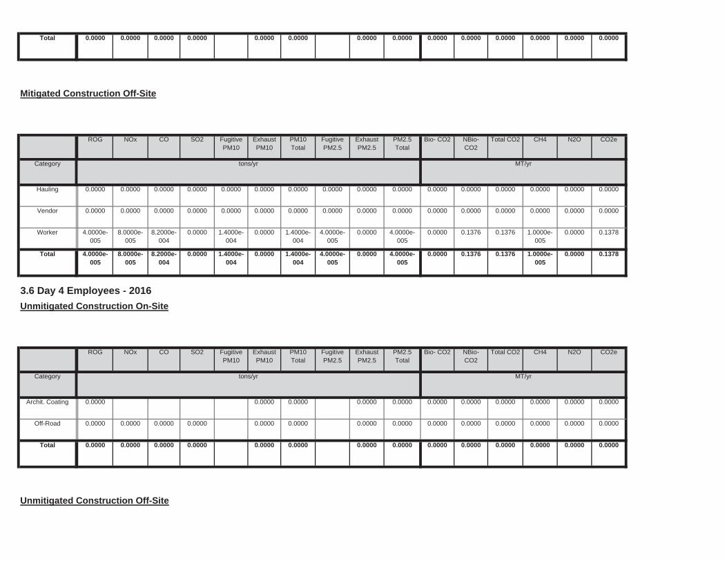
Unmitigated Construction Off-Site
0.0000 0.0000 0.0000 0.0000 0.0000 0.00000.0000 0.0000 0.0000 0.0000Total 0.0000 0.0000 0.0000 0.0000
0.0000 0.0000 0.0000 0.0000 0.0000 0.00000.0000 0.0000 0.0000 0.0000Off-Road 0.0000 0.0000 0.0000 0.0000
0.0000 0.0000 0.0000 0.0000 0.0000 0.00000.0000 0.0000 0.0000 0.0000Archit. Coating 0.0000
Total CO2 CH4 N2O CO2e
Category tons/yr MT/yr
PM10Total
FugitivePM2.5
ExhaustPM2.5
PM2.5Total
Bio- CO2 NBio- CO2
3.6 Day 4 Employees - 2016
Unmitigated Construction On-Site
ROG NOx CO SO2 Fugitive PM10
ExhaustPM10
0.0000 0.1376 0.1376 1.0000e-005
0.0000 0.13781.4000e-004
0.0000 1.4000e-004
4.0000e-005
0.0000 4.0000e-005
Total 4.0000e-005
8.0000e-005
8.2000e-004
0.0000
0.0000 0.1376 0.1376 1.0000e-005
0.0000 0.13781.4000e-004
0.0000 1.4000e-004
4.0000e-005
0.0000 4.0000e-005
Worker 4.0000e-005
8.0000e-005
8.2000e-004
0.0000
0.0000 0.0000 0.0000 0.0000 0.0000 0.00000.0000 0.0000 0.0000 0.0000 0.0000 0.0000Vendor 0.0000 0.0000 0.0000 0.0000
0.0000 0.0000 0.0000 0.0000 0.0000 0.00000.0000 0.0000 0.0000 0.0000 0.0000 0.0000Hauling 0.0000 0.0000 0.0000 0.0000
Total CO2 CH4 N2O CO2e
Category tons/yr MT/yr
PM10Total
FugitivePM2.5
ExhaustPM2.5
PM2.5Total
Bio- CO2 NBio- CO2
Mitigated Construction Off-Site
ROG NOx CO SO2 Fugitive PM10
ExhaustPM10
0.0000 0.0000 0.0000 0.0000 0.0000 0.00000.0000 0.0000 0.0000 0.0000Total 0.0000 0.0000 0.0000 0.0000
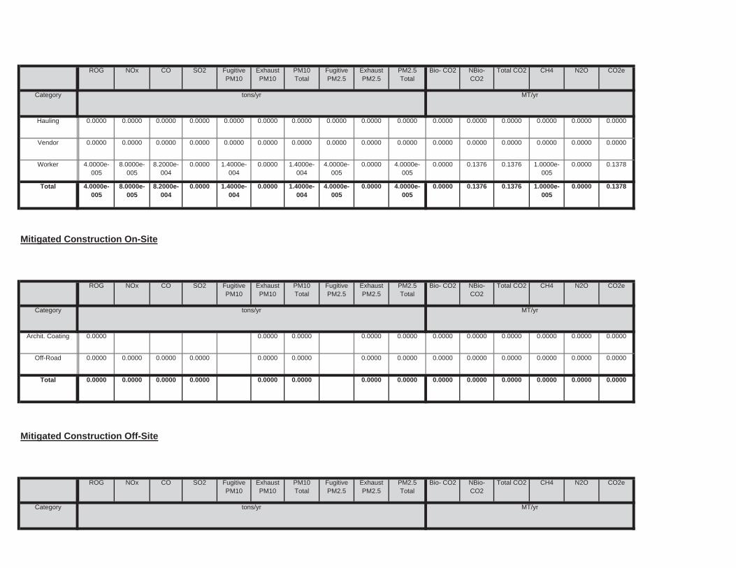
Total CO2 CH4 N2O CO2e
Category tons/yr MT/yr
PM10Total
FugitivePM2.5
ExhaustPM2.5
PM2.5Total
Bio- CO2 NBio- CO2
Mitigated Construction Off-Site
ROG NOx CO SO2 Fugitive PM10
ExhaustPM10
0.0000 0.0000 0.0000 0.0000 0.0000 0.00000.0000 0.0000 0.0000 0.0000Total 0.0000 0.0000 0.0000 0.0000
0.0000 0.0000 0.0000 0.0000 0.0000 0.00000.0000 0.0000 0.0000 0.0000Off-Road 0.0000 0.0000 0.0000 0.0000
0.0000 0.0000 0.0000 0.0000 0.0000 0.00000.0000 0.0000 0.0000 0.0000Archit. Coating 0.0000
Total CO2 CH4 N2O CO2e
Category tons/yr MT/yr
PM10Total
FugitivePM2.5
ExhaustPM2.5
PM2.5Total
Bio- CO2 NBio- CO2
Mitigated Construction On-Site
ROG NOx CO SO2 Fugitive PM10
ExhaustPM10
0.0000 0.1376 0.1376 1.0000e-005
0.0000 0.13781.4000e-004
0.0000 1.4000e-004
4.0000e-005
0.0000 4.0000e-005
Total 4.0000e-005
8.0000e-005
8.2000e-004
0.0000
0.0000 0.1376 0.1376 1.0000e-005
0.0000 0.13781.4000e-004
0.0000 1.4000e-004
4.0000e-005
0.0000 4.0000e-005
Worker 4.0000e-005
8.0000e-005
8.2000e-004
0.0000
0.0000 0.0000 0.0000 0.0000 0.0000 0.00000.0000 0.0000 0.0000 0.0000 0.0000 0.0000Vendor 0.0000 0.0000 0.0000 0.0000
0.0000 0.0000 0.0000 0.0000 0.0000 0.00000.0000 0.0000 0.0000 0.0000 0.0000 0.0000Hauling 0.0000 0.0000 0.0000 0.0000
Total CO2 CH4 N2O CO2e
Category tons/yr MT/yr
PM10Total
FugitivePM2.5
ExhaustPM2.5
PM2.5Total
Bio- CO2 NBio- CO2
ROG NOx CO SO2 Fugitive PM10
ExhaustPM10
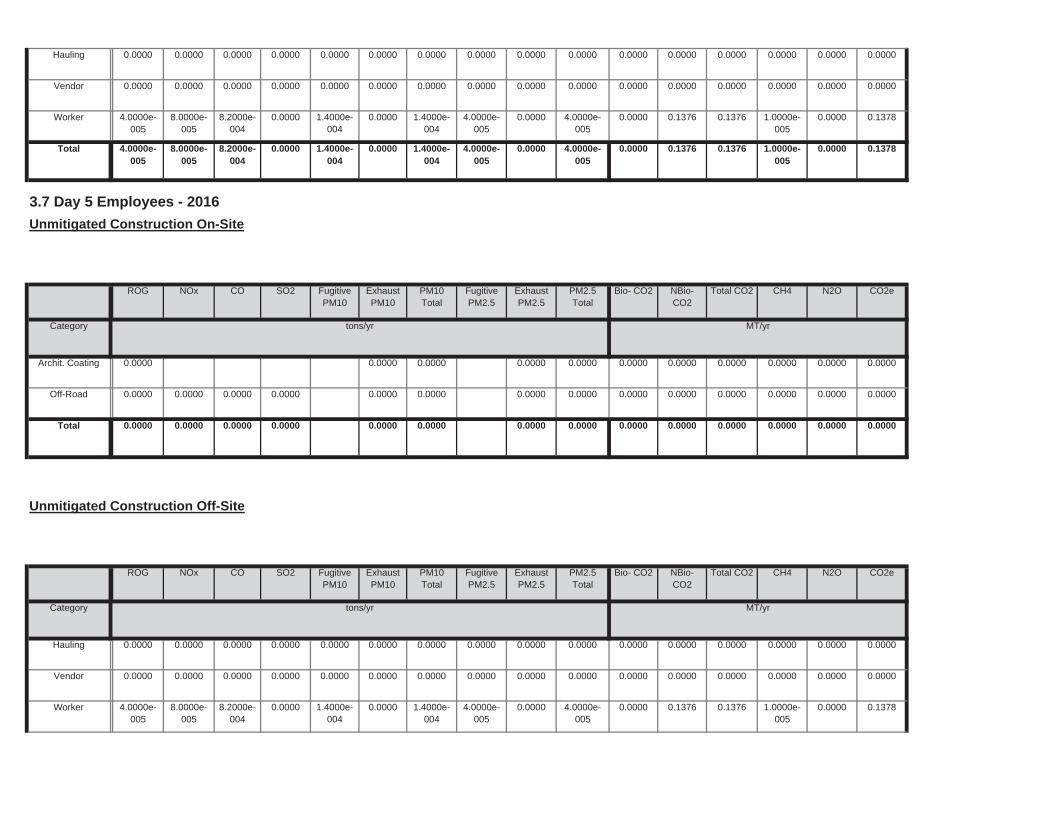
0.0000 0.1376 0.1376 1.0000e-005
0.0000 0.13781.4000e-004
0.0000 1.4000e-004
4.0000e-005
0.0000 4.0000e-005
Worker 4.0000e-005
8.0000e-005
8.2000e-004
0.0000
0.0000 0.0000 0.0000 0.0000 0.0000 0.00000.0000 0.0000 0.0000 0.0000 0.0000 0.0000Vendor 0.0000 0.0000 0.0000 0.0000
0.0000 0.0000 0.0000 0.0000 0.0000 0.00000.0000 0.0000 0.0000 0.0000 0.0000 0.0000Hauling 0.0000 0.0000 0.0000 0.0000
Total CO2 CH4 N2O CO2e
Category tons/yr MT/yr
PM10Total
FugitivePM2.5
ExhaustPM2.5
PM2.5Total
Bio- CO2 NBio- CO2
Unmitigated Construction Off-Site
ROG NOx CO SO2 Fugitive PM10
ExhaustPM10
0.0000 0.0000 0.0000 0.0000 0.0000 0.00000.0000 0.0000 0.0000 0.0000Total 0.0000 0.0000 0.0000 0.0000
0.0000 0.0000 0.0000 0.0000 0.0000 0.00000.0000 0.0000 0.0000 0.0000Off-Road 0.0000 0.0000 0.0000 0.0000
0.0000 0.0000 0.0000 0.0000 0.0000 0.00000.0000 0.0000 0.0000 0.0000Archit. Coating 0.0000
Total CO2 CH4 N2O CO2e
Category tons/yr MT/yr
PM10Total
FugitivePM2.5
ExhaustPM2.5
PM2.5Total
Bio- CO2 NBio- CO2
3.7 Day 5 Employees - 2016
Unmitigated Construction On-Site
ROG NOx CO SO2 Fugitive PM10
ExhaustPM10
0.0000 0.1376 0.1376 1.0000e-005
0.0000 0.13781.4000e-004
0.0000 1.4000e-004
4.0000e-005
0.0000 4.0000e-005
Total 4.0000e-005
8.0000e-005
8.2000e-004
0.0000
0.0000 0.1376 0.1376 1.0000e-005
0.0000 0.13781.4000e-004
0.0000 1.4000e-004
4.0000e-005
0.0000 4.0000e-005
Worker 4.0000e-005
8.0000e-005
8.2000e-004
0.0000
0.0000 0.0000 0.0000 0.0000 0.0000 0.00000.0000 0.0000 0.0000 0.0000 0.0000 0.0000Vendor 0.0000 0.0000 0.0000 0.0000
0.0000 0.0000 0.0000 0.0000 0.0000 0.00000.0000 0.0000 0.0000 0.0000 0.0000 0.0000Hauling 0.0000 0.0000 0.0000 0.0000
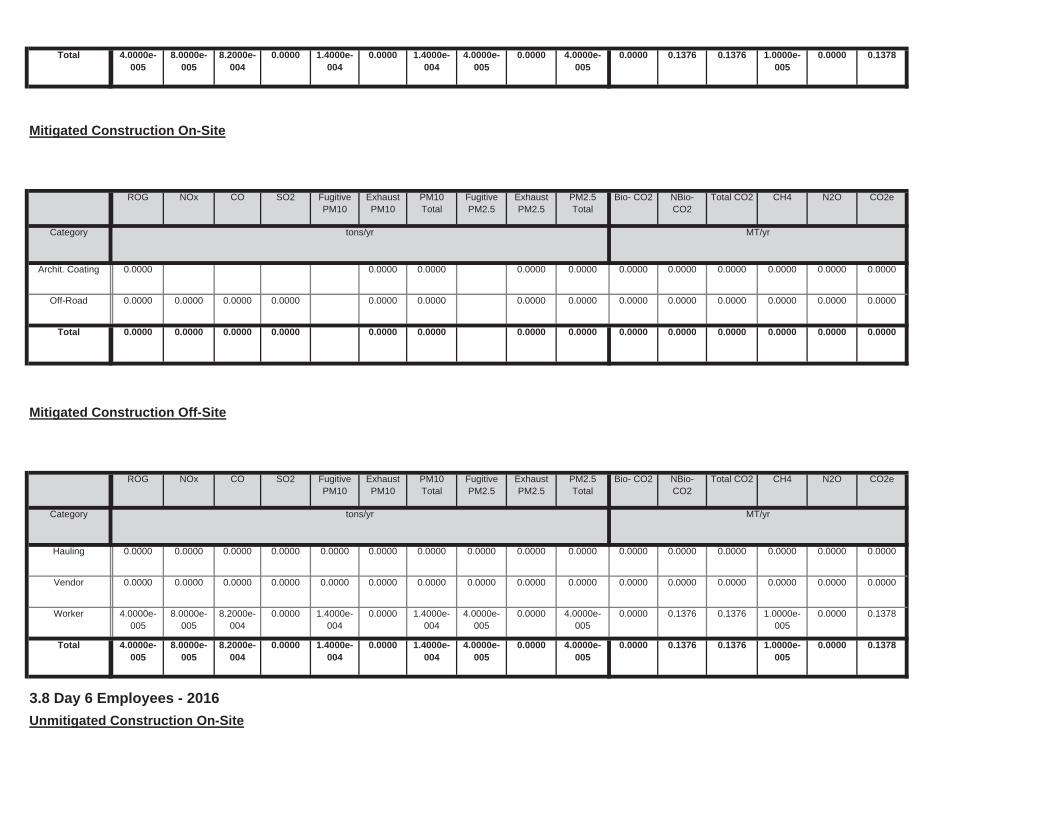
3.8 Day 6 Employees - 2016
Unmitigated Construction On-Site
0.0000 0.1376 0.1376 1.0000e-005
0.0000 0.13781.4000e-004
0.0000 1.4000e-004
4.0000e-005
0.0000 4.0000e-005
Total 4.0000e-005
8.0000e-005
8.2000e-004
0.0000
0.0000 0.1376 0.1376 1.0000e-005
0.0000 0.13781.4000e-004
0.0000 1.4000e-004
4.0000e-005
0.0000 4.0000e-005
Worker 4.0000e-005
8.0000e-005
8.2000e-004
0.0000
0.0000 0.0000 0.0000 0.0000 0.0000 0.00000.0000 0.0000 0.0000 0.0000 0.0000 0.0000Vendor 0.0000 0.0000 0.0000 0.0000
0.0000 0.0000 0.0000 0.0000 0.0000 0.00000.0000 0.0000 0.0000 0.0000 0.0000 0.0000Hauling 0.0000 0.0000 0.0000 0.0000
Total CO2 CH4 N2O CO2e
Category tons/yr MT/yr
PM10Total
FugitivePM2.5
ExhaustPM2.5
PM2.5Total
Bio- CO2 NBio- CO2
Mitigated Construction Off-Site
ROG NOx CO SO2 Fugitive PM10
ExhaustPM10
0.0000 0.0000 0.0000 0.0000 0.0000 0.00000.0000 0.0000 0.0000 0.0000Total 0.0000 0.0000 0.0000 0.0000
0.0000 0.0000 0.0000 0.0000 0.0000 0.00000.0000 0.0000 0.0000 0.0000Off-Road 0.0000 0.0000 0.0000 0.0000
0.0000 0.0000 0.0000 0.0000 0.0000 0.00000.0000 0.0000 0.0000 0.0000Archit. Coating 0.0000
Total CO2 CH4 N2O CO2e
Category tons/yr MT/yr
PM10Total
FugitivePM2.5
ExhaustPM2.5
PM2.5Total
Bio- CO2 NBio- CO2
Mitigated Construction On-Site
ROG NOx CO SO2 Fugitive PM10
ExhaustPM10
0.0000 0.1376 0.1376 1.0000e-005
0.0000 0.13781.4000e-004
0.0000 1.4000e-004
4.0000e-005
0.0000 4.0000e-005
Total 4.0000e-005
8.0000e-005
8.2000e-004
0.0000
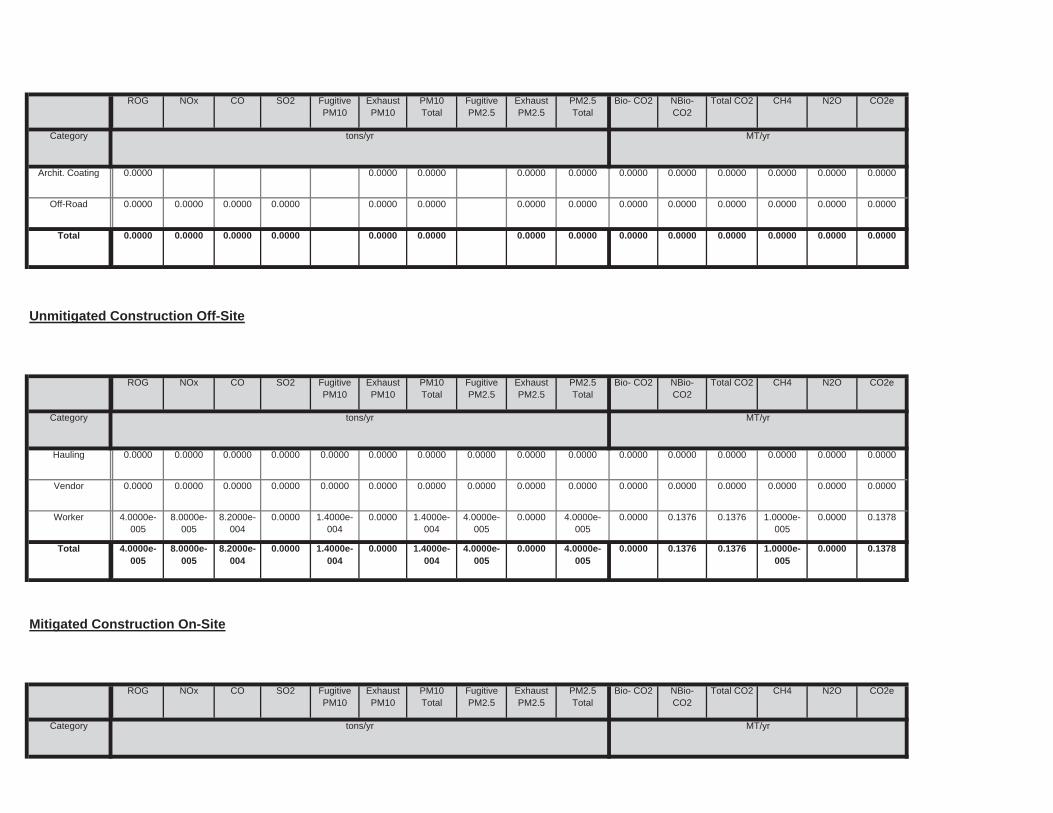
0.0000 0.1376 0.1376 1.0000e-005
0.0000 0.13781.4000e-004
0.0000 1.4000e-004
4.0000e-005
0.0000 4.0000e-005
Worker 4.0000e-005
8.0000e-005
8.2000e-004
0.0000
0.0000 0.0000 0.0000 0.0000 0.0000 0.00000.0000 0.0000 0.0000 0.0000 0.0000 0.0000Vendor 0.0000 0.0000 0.0000 0.0000
0.0000 0.0000 0.0000 0.0000 0.0000 0.00000.0000 0.0000 0.0000 0.0000 0.0000 0.0000Hauling 0.0000 0.0000 0.0000 0.0000
Total CO2 CH4 N2O CO2e
Category tons/yr MT/yr
PM10Total
FugitivePM2.5
ExhaustPM2.5
PM2.5Total
Bio- CO2 NBio- CO2
Unmitigated Construction Off-Site
ROG NOx CO SO2 Fugitive PM10
ExhaustPM10
0.0000 0.0000 0.0000 0.0000 0.0000 0.00000.0000 0.0000 0.0000 0.0000Total 0.0000 0.0000 0.0000 0.0000
0.0000 0.0000 0.0000 0.0000 0.0000 0.00000.0000 0.0000 0.0000 0.0000Off-Road 0.0000 0.0000 0.0000 0.0000
0.0000 0.0000 0.0000 0.0000 0.0000 0.00000.0000 0.0000 0.0000 0.0000Archit. Coating 0.0000
Total CO2 CH4 N2O CO2e
Category tons/yr MT/yr
PM10Total
FugitivePM2.5
ExhaustPM2.5
PM2.5Total
Bio- CO2 NBio- CO2
ROG NOx CO SO2 Fugitive PM10
ExhaustPM10
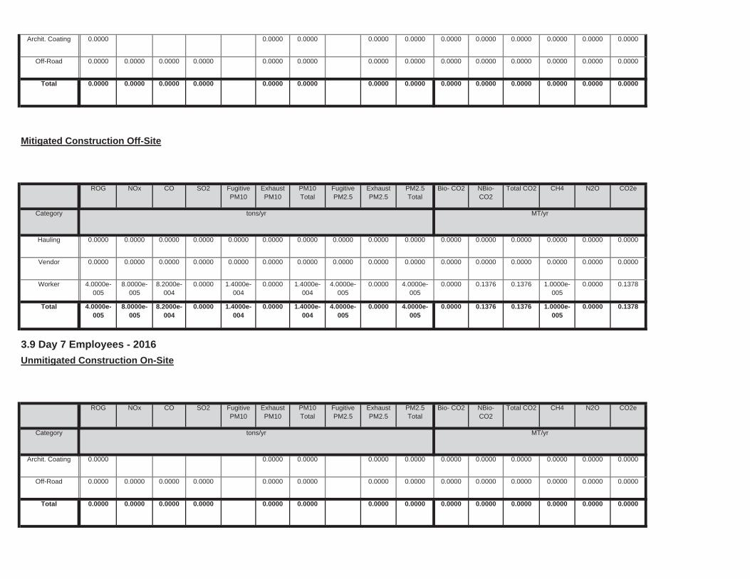
0.0000 0.0000 0.0000 0.0000 0.0000 0.00000.0000 0.0000 0.0000 0.0000Total 0.0000 0.0000 0.0000 0.0000
0.0000 0.0000 0.0000 0.0000 0.0000 0.00000.0000 0.0000 0.0000 0.0000Off-Road 0.0000 0.0000 0.0000 0.0000
0.0000 0.0000 0.0000 0.0000 0.0000 0.00000.0000 0.0000 0.0000 0.0000Archit. Coating 0.0000
Total CO2 CH4 N2O CO2e
Category tons/yr MT/yr
PM10Total
FugitivePM2.5
ExhaustPM2.5
PM2.5Total
Bio- CO2 NBio- CO2
3.9 Day 7 Employees - 2016
Unmitigated Construction On-Site
ROG NOx CO SO2 Fugitive PM10
ExhaustPM10
0.0000 0.1376 0.1376 1.0000e-005
0.0000 0.13781.4000e-004
0.0000 1.4000e-004
4.0000e-005
0.0000 4.0000e-005
Total 4.0000e-005
8.0000e-005
8.2000e-004
0.0000
0.0000 0.1376 0.1376 1.0000e-005
0.0000 0.13781.4000e-004
0.0000 1.4000e-004
4.0000e-005
0.0000 4.0000e-005
Worker 4.0000e-005
8.0000e-005
8.2000e-004
0.0000
0.0000 0.0000 0.0000 0.0000 0.0000 0.00000.0000 0.0000 0.0000 0.0000 0.0000 0.0000Vendor 0.0000 0.0000 0.0000 0.0000
0.0000 0.0000 0.0000 0.0000 0.0000 0.00000.0000 0.0000 0.0000 0.0000 0.0000 0.0000Hauling 0.0000 0.0000 0.0000 0.0000
Total CO2 CH4 N2O CO2e
Category tons/yr MT/yr
PM10Total
FugitivePM2.5
ExhaustPM2.5
PM2.5Total
Bio- CO2 NBio- CO2
Mitigated Construction Off-Site
ROG NOx CO SO2 Fugitive PM10
ExhaustPM10
0.0000 0.0000 0.0000 0.0000 0.0000 0.00000.0000 0.0000 0.0000 0.0000Total 0.0000 0.0000 0.0000 0.0000
0.0000 0.0000 0.0000 0.0000 0.0000 0.00000.0000 0.0000 0.0000 0.0000Off-Road 0.0000 0.0000 0.0000 0.0000
0.0000 0.0000 0.0000 0.0000 0.0000 0.00000.0000 0.0000 0.0000 0.0000Archit. Coating 0.0000
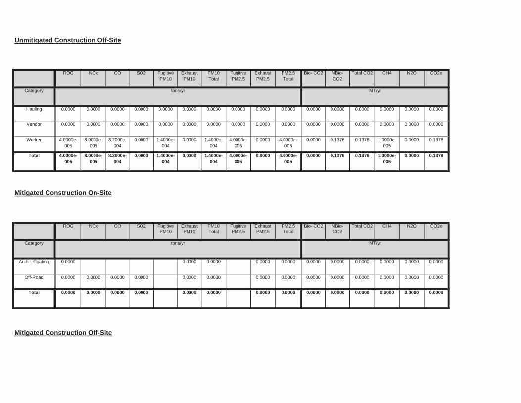
Mitigated Construction Off-Site
0.0000 0.0000 0.0000 0.0000 0.0000 0.00000.0000 0.0000 0.0000 0.0000Total 0.0000 0.0000 0.0000 0.0000
0.0000 0.0000 0.0000 0.0000 0.0000 0.00000.0000 0.0000 0.0000 0.0000Off-Road 0.0000 0.0000 0.0000 0.0000
0.0000 0.0000 0.0000 0.0000 0.0000 0.00000.0000 0.0000 0.0000 0.0000Archit. Coating 0.0000
Total CO2 CH4 N2O CO2e
Category tons/yr MT/yr
PM10Total
FugitivePM2.5
ExhaustPM2.5
PM2.5Total
Bio- CO2 NBio- CO2
Mitigated Construction On-Site
ROG NOx CO SO2 Fugitive PM10
ExhaustPM10
0.0000 0.1376 0.1376 1.0000e-005
0.0000 0.13781.4000e-004
0.0000 1.4000e-004
4.0000e-005
0.0000 4.0000e-005
Total 4.0000e-005
8.0000e-005
8.2000e-004
0.0000
0.0000 0.1376 0.1376 1.0000e-005
0.0000 0.13781.4000e-004
0.0000 1.4000e-004
4.0000e-005
0.0000 4.0000e-005
Worker 4.0000e-005
8.0000e-005
8.2000e-004
0.0000
0.0000 0.0000 0.0000 0.0000 0.0000 0.00000.0000 0.0000 0.0000 0.0000 0.0000 0.0000Vendor 0.0000 0.0000 0.0000 0.0000
0.0000 0.0000 0.0000 0.0000 0.0000 0.00000.0000 0.0000 0.0000 0.0000 0.0000 0.0000Hauling 0.0000 0.0000 0.0000 0.0000
Total CO2 CH4 N2O CO2e
Category tons/yr MT/yr
PM10Total
FugitivePM2.5
ExhaustPM2.5
PM2.5Total
Bio- CO2 NBio- CO2
Unmitigated Construction Off-Site
ROG NOx CO SO2 Fugitive PM10
ExhaustPM10
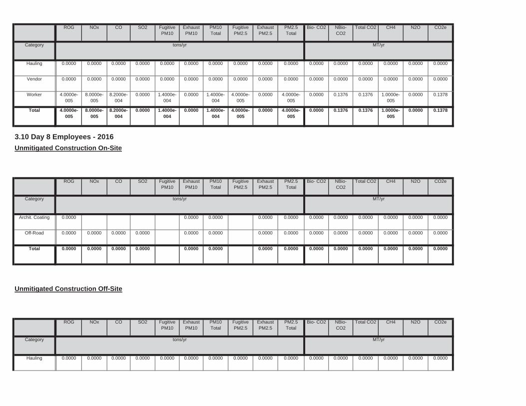
0.0000 0.0000 0.0000 0.0000 0.0000 0.00000.0000 0.0000 0.0000 0.0000Total 0.0000 0.0000 0.0000 0.0000
0.0000 0.0000 0.0000 0.0000 0.0000 0.00000.0000 0.0000 0.0000 0.0000Off-Road 0.0000 0.0000 0.0000 0.0000
0.0000 0.0000 0.0000 0.0000 0.0000 0.00000.0000 0.0000 0.0000 0.0000Archit. Coating 0.0000
Total CO2 CH4 N2O CO2e
Category tons/yr MT/yr
PM10Total
FugitivePM2.5
ExhaustPM2.5
PM2.5Total
Bio- CO2 NBio- CO2
3.10 Day 8 Employees - 2016
Unmitigated Construction On-Site
ROG NOx CO SO2 Fugitive PM10
ExhaustPM10
0.0000 0.1376 0.1376 1.0000e-005
0.0000 0.13781.4000e-004
0.0000 1.4000e-004
4.0000e-005
0.0000 4.0000e-005
Total 4.0000e-005
8.0000e-005
8.2000e-004
0.0000
0.0000 0.1376 0.1376 1.0000e-005
0.0000 0.13781.4000e-004
0.0000 1.4000e-004
4.0000e-005
0.0000 4.0000e-005
Worker 4.0000e-005
8.0000e-005
8.2000e-004
0.0000
0.0000 0.0000 0.0000 0.0000 0.0000 0.00000.0000 0.0000 0.0000 0.0000 0.0000 0.0000Vendor 0.0000 0.0000 0.0000 0.0000
0.0000 0.0000 0.0000 0.0000 0.0000 0.00000.0000 0.0000 0.0000 0.0000 0.0000 0.0000Hauling 0.0000 0.0000 0.0000 0.0000
Total CO2 CH4 N2O CO2e
Category tons/yr MT/yr
PM10Total
FugitivePM2.5
ExhaustPM2.5
PM2.5Total
Bio- CO2 NBio- CO2
ROG NOx CO SO2 Fugitive PM10
ExhaustPM10
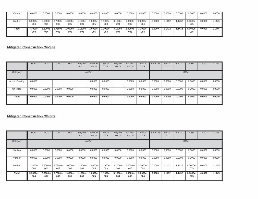
0.0000 1.1432 1.1432 6.0000e-005
0.0000 1.14451.1800e-003
1.0000e-005
1.1900e-003
3.1000e-004
1.0000e-005
3.2000e-004
Total 3.3000e-004
6.6000e-004
6.7800e-003
1.0000e-005
0.0000 1.1432 1.1432 6.0000e-005
0.0000 1.14451.1800e-003
1.0000e-005
1.1900e-003
3.1000e-004
1.0000e-005
3.2000e-004
Worker 3.3000e-004
6.6000e-004
6.7800e-003
1.0000e-005
0.0000 0.0000 0.0000 0.0000 0.0000 0.00000.0000 0.0000 0.0000 0.0000 0.0000 0.0000Vendor 0.0000 0.0000 0.0000 0.0000
0.0000 0.0000 0.0000 0.0000 0.0000 0.00000.0000 0.0000 0.0000 0.0000 0.0000 0.0000Hauling 0.0000 0.0000 0.0000 0.0000
Total CO2 CH4 N2O CO2e
Category tons/yr MT/yr
PM10Total
FugitivePM2.5
ExhaustPM2.5
PM2.5Total
Bio- CO2 NBio- CO2
Mitigated Construction Off-Site
ROG NOx CO SO2 Fugitive PM10
ExhaustPM10
0.0000 0.0000 0.0000 0.0000 0.0000 0.00000.0000 0.0000 0.0000 0.0000Total 0.0000 0.0000 0.0000 0.0000
0.0000 0.0000 0.0000 0.0000 0.0000 0.00000.0000 0.0000 0.0000 0.0000Off-Road 0.0000 0.0000 0.0000 0.0000
0.0000 0.0000 0.0000 0.0000 0.0000 0.00000.0000 0.0000 0.0000 0.0000Archit. Coating 0.0000
Total CO2 CH4 N2O CO2e
Category tons/yr MT/yr
PM10Total
FugitivePM2.5
ExhaustPM2.5
PM2.5Total
Bio- CO2 NBio- CO2
Mitigated Construction On-Site
ROG NOx CO SO2 Fugitive PM10
ExhaustPM10
0.0000 1.1432 1.1432 6.0000e-005
0.0000 1.14451.1800e-003
1.0000e-005
1.1900e-003
3.1000e-004
1.0000e-005
3.2000e-004
Total 3.3000e-004
6.6000e-004
6.7800e-003
1.0000e-005
0.0000 1.1432 1.1432 6.0000e-005
0.0000 1.14451.1800e-003
1.0000e-005
1.1900e-003
3.1000e-004
1.0000e-005
3.2000e-004
Worker 3.3000e-004
6.6000e-004
6.7800e-003
1.0000e-005
0.0000 0.0000 0.0000 0.0000 0.0000 0.00000.0000 0.0000 0.0000 0.0000 0.0000 0.0000Vendor 0.0000 0.0000 0.0000 0.0000
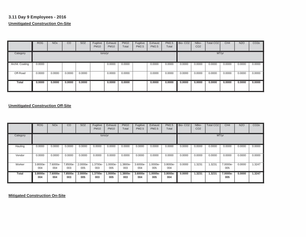
Mitigated Construction On-Site
0.0000 1.3231 1.3231 7.0000e-005
0.0000 1.32471.3700e-003
1.0000e-005
1.3800e-003
3.6000e-004
1.0000e-005
3.8000e-004
Total 3.8000e-004
7.6000e-004
7.8500e-003
2.0000e-005
0.0000 1.3231 1.3231 7.0000e-005
0.0000 1.32471.3700e-003
1.0000e-005
1.3800e-003
3.6000e-004
1.0000e-005
3.8000e-004
Worker 3.8000e-004
7.6000e-004
7.8500e-003
2.0000e-005
0.0000 0.0000 0.0000 0.0000 0.0000 0.00000.0000 0.0000 0.0000 0.0000 0.0000 0.0000Vendor 0.0000 0.0000 0.0000 0.0000
0.0000 0.0000 0.0000 0.0000 0.0000 0.00000.0000 0.0000 0.0000 0.0000 0.0000 0.0000Hauling 0.0000 0.0000 0.0000 0.0000
Total CO2 CH4 N2O CO2e
Category tons/yr MT/yr
PM10Total
FugitivePM2.5
ExhaustPM2.5
PM2.5Total
Bio- CO2 NBio- CO2
Unmitigated Construction Off-Site
ROG NOx CO SO2 Fugitive PM10
ExhaustPM10
0.0000 0.0000 0.0000 0.0000 0.0000 0.00000.0000 0.0000 0.0000 0.0000Total 0.0000 0.0000 0.0000 0.0000
0.0000 0.0000 0.0000 0.0000 0.0000 0.00000.0000 0.0000 0.0000 0.0000Off-Road 0.0000 0.0000 0.0000 0.0000
0.0000 0.0000 0.0000 0.0000 0.0000 0.00000.0000 0.0000 0.0000 0.0000Archit. Coating 0.0000
Total CO2 CH4 N2O CO2e
Category tons/yr MT/yr
PM10Total
FugitivePM2.5
ExhaustPM2.5
PM2.5Total
Bio- CO2 NBio- CO2
3.11 Day 9 Employees - 2016
Unmitigated Construction On-Site
ROG NOx CO SO2 Fugitive PM10
ExhaustPM10
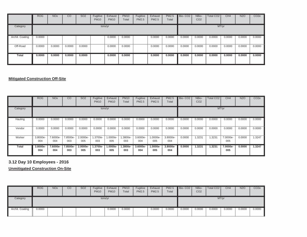
0.0000 0.0000 0.0000 0.0000 0.0000 0.00000.0000 0.0000 0.0000 0.0000Archit. Coating 0.0000
Total CO2 CH4 N2O CO2e
Category tons/yr MT/yr
PM10Total
FugitivePM2.5
ExhaustPM2.5
PM2.5Total
Bio- CO2 NBio- CO2
3.12 Day 10 Employees - 2016
Unmitigated Construction On-Site
ROG NOx CO SO2 Fugitive PM10
ExhaustPM10
0.0000 1.3231 1.3231 7.0000e-005
0.0000 1.32471.3700e-003
1.0000e-005
1.3800e-003
3.6000e-004
1.0000e-005
3.8000e-004
Total 3.8000e-004
7.6000e-004
7.8500e-003
2.0000e-005
0.0000 1.3231 1.3231 7.0000e-005
0.0000 1.32471.3700e-003
1.0000e-005
1.3800e-003
3.6000e-004
1.0000e-005
3.8000e-004
Worker 3.8000e-004
7.6000e-004
7.8500e-003
2.0000e-005
0.0000 0.0000 0.0000 0.0000 0.0000 0.00000.0000 0.0000 0.0000 0.0000 0.0000 0.0000Vendor 0.0000 0.0000 0.0000 0.0000
0.0000 0.0000 0.0000 0.0000 0.0000 0.00000.0000 0.0000 0.0000 0.0000 0.0000 0.0000Hauling 0.0000 0.0000 0.0000 0.0000
Total CO2 CH4 N2O CO2e
Category tons/yr MT/yr
PM10Total
FugitivePM2.5
ExhaustPM2.5
PM2.5Total
Bio- CO2 NBio- CO2
Mitigated Construction Off-Site
ROG NOx CO SO2 Fugitive PM10
ExhaustPM10
0.0000 0.0000 0.0000 0.0000 0.0000 0.00000.0000 0.0000 0.0000 0.0000Total 0.0000 0.0000 0.0000 0.0000
0.0000 0.0000 0.0000 0.0000 0.0000 0.00000.0000 0.0000 0.0000 0.0000Off-Road 0.0000 0.0000 0.0000 0.0000
0.0000 0.0000 0.0000 0.0000 0.0000 0.00000.0000 0.0000 0.0000 0.0000Archit. Coating 0.0000
Total CO2 CH4 N2O CO2e
Category tons/yr MT/yr
PM10Total
FugitivePM2.5
ExhaustPM2.5
PM2.5Total
Bio- CO2 NBio- CO2
ROG NOx CO SO2 Fugitive PM10
ExhaustPM10
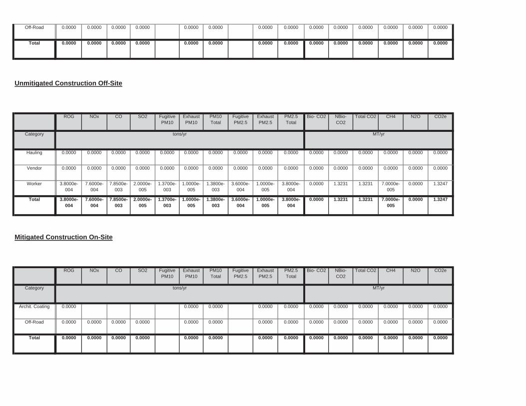
0.0000 0.0000 0.0000 0.0000 0.0000 0.00000.0000 0.0000 0.0000 0.0000Total 0.0000 0.0000 0.0000 0.0000
0.0000 0.0000 0.0000 0.0000 0.0000 0.00000.0000 0.0000 0.0000 0.0000Off-Road 0.0000 0.0000 0.0000 0.0000
0.0000 0.0000 0.0000 0.0000 0.0000 0.00000.0000 0.0000 0.0000 0.0000Archit. Coating 0.0000
Total CO2 CH4 N2O CO2e
Category tons/yr MT/yr
PM10Total
FugitivePM2.5
ExhaustPM2.5
PM2.5Total
Bio- CO2 NBio- CO2
Mitigated Construction On-Site
ROG NOx CO SO2 Fugitive PM10
ExhaustPM10
0.0000 1.3231 1.3231 7.0000e-005
0.0000 1.32471.3700e-003
1.0000e-005
1.3800e-003
3.6000e-004
1.0000e-005
3.8000e-004
Total 3.8000e-004
7.6000e-004
7.8500e-003
2.0000e-005
0.0000 1.3231 1.3231 7.0000e-005
0.0000 1.32471.3700e-003
1.0000e-005
1.3800e-003
3.6000e-004
1.0000e-005
3.8000e-004
Worker 3.8000e-004
7.6000e-004
7.8500e-003
2.0000e-005
0.0000 0.0000 0.0000 0.0000 0.0000 0.00000.0000 0.0000 0.0000 0.0000 0.0000 0.0000Vendor 0.0000 0.0000 0.0000 0.0000
0.0000 0.0000 0.0000 0.0000 0.0000 0.00000.0000 0.0000 0.0000 0.0000 0.0000 0.0000Hauling 0.0000 0.0000 0.0000 0.0000
Total CO2 CH4 N2O CO2e
Category tons/yr MT/yr
PM10Total
FugitivePM2.5
ExhaustPM2.5
PM2.5Total
Bio- CO2 NBio- CO2
Unmitigated Construction Off-Site
ROG NOx CO SO2 Fugitive PM10
ExhaustPM10
0.0000 0.0000 0.0000 0.0000 0.0000 0.00000.0000 0.0000 0.0000 0.0000Total 0.0000 0.0000 0.0000 0.0000
0.0000 0.0000 0.0000 0.0000 0.0000 0.00000.0000 0.0000 0.0000 0.0000Off-Road 0.0000 0.0000 0.0000 0.0000
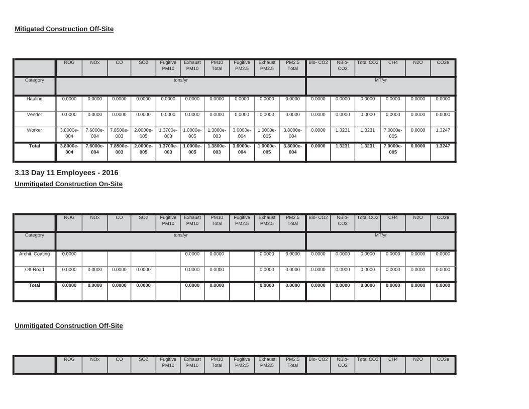
Total CO2 CH4 N2O CO2ePM10Total
FugitivePM2.5
ExhaustPM2.5
PM2.5Total
Bio- CO2 NBio- CO2
Unmitigated Construction Off-Site
ROG NOx CO SO2 Fugitive PM10
ExhaustPM10
0.0000 0.0000 0.0000 0.0000 0.0000 0.00000.0000 0.0000 0.0000 0.0000Total 0.0000 0.0000 0.0000 0.0000
0.0000 0.0000 0.0000 0.0000 0.0000 0.00000.0000 0.0000 0.0000 0.0000Off-Road 0.0000 0.0000 0.0000 0.0000
0.0000 0.0000 0.0000 0.0000 0.0000 0.00000.0000 0.0000 0.0000 0.0000Archit. Coating 0.0000
Total CO2 CH4 N2O CO2e
Category tons/yr MT/yr
PM10Total
FugitivePM2.5
ExhaustPM2.5
PM2.5Total
Bio- CO2 NBio- CO2
3.13 Day 11 Employees - 2016
Unmitigated Construction On-Site
ROG NOx CO SO2 Fugitive PM10
ExhaustPM10
0.0000 1.3231 1.3231 7.0000e-005
0.0000 1.32471.3700e-003
1.0000e-005
1.3800e-003
3.6000e-004
1.0000e-005
3.8000e-004
Total 3.8000e-004
7.6000e-004
7.8500e-003
2.0000e-005
0.0000 1.3231 1.3231 7.0000e-005
0.0000 1.32471.3700e-003
1.0000e-005
1.3800e-003
3.6000e-004
1.0000e-005
3.8000e-004
Worker 3.8000e-004
7.6000e-004
7.8500e-003
2.0000e-005
0.0000 0.0000 0.0000 0.0000 0.0000 0.00000.0000 0.0000 0.0000 0.0000 0.0000 0.0000Vendor 0.0000 0.0000 0.0000 0.0000
0.0000 0.0000 0.0000 0.0000 0.0000 0.00000.0000 0.0000 0.0000 0.0000 0.0000 0.0000Hauling 0.0000 0.0000 0.0000 0.0000
Total CO2 CH4 N2O CO2e
Category tons/yr MT/yr
PM10Total
FugitivePM2.5
ExhaustPM2.5
PM2.5Total
Bio- CO2 NBio- CO2
Mitigated Construction Off-Site
ROG NOx CO SO2 Fugitive PM10
ExhaustPM10
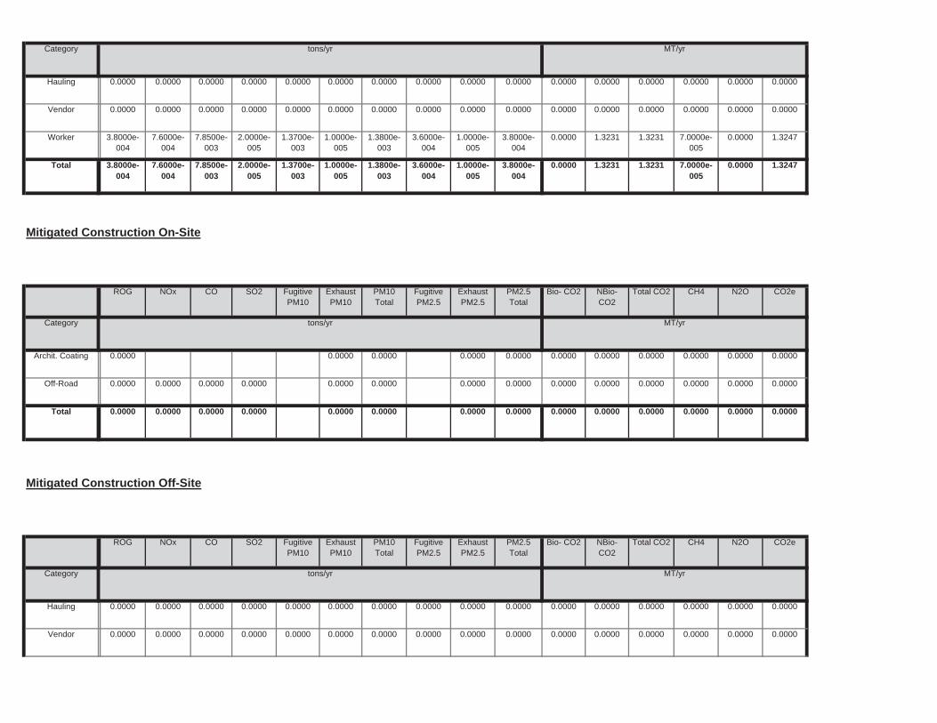
0.0000 0.0000 0.0000 0.0000 0.0000 0.00000.0000 0.0000 0.0000 0.0000Total 0.0000 0.0000 0.0000 0.0000
0.0000 0.0000 0.0000 0.0000 0.0000 0.00000.0000 0.0000 0.0000 0.0000Off-Road 0.0000 0.0000 0.0000 0.0000
0.0000 0.0000 0.0000 0.0000 0.0000 0.00000.0000 0.0000 0.0000 0.0000Archit. Coating 0.0000
Total CO2 CH4 N2O CO2e
Category tons/yr MT/yr
PM10Total
FugitivePM2.5
ExhaustPM2.5
PM2.5Total
Bio- CO2 NBio- CO2
Mitigated Construction On-Site
ROG NOx CO SO2 Fugitive PM10
ExhaustPM10
0.0000 1.3231 1.3231 7.0000e-005
0.0000 1.32471.3700e-003
1.0000e-005
1.3800e-003
3.6000e-004
1.0000e-005
3.8000e-004
Total 3.8000e-004
7.6000e-004
7.8500e-003
2.0000e-005
0.0000 1.3231 1.3231 7.0000e-005
0.0000 1.32471.3700e-003
1.0000e-005
1.3800e-003
3.6000e-004
1.0000e-005
3.8000e-004
Worker 3.8000e-004
7.6000e-004
7.8500e-003
2.0000e-005
0.0000 0.0000 0.0000 0.0000 0.0000 0.00000.0000 0.0000 0.0000 0.0000 0.0000 0.0000Vendor 0.0000 0.0000 0.0000 0.0000
0.0000 0.0000 0.0000 0.0000 0.0000 0.00000.0000 0.0000 0.0000 0.0000 0.0000 0.0000Hauling 0.0000 0.0000 0.0000 0.0000
Category tons/yr MT/yr
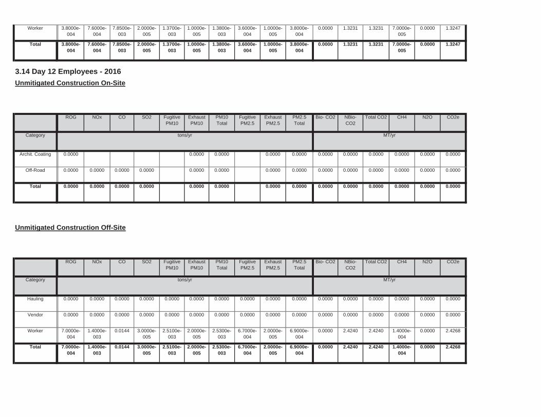
0.0000 2.4240 2.4240 1.4000e-004
0.0000 2.42682.5100e-003
2.0000e-005
2.5300e-003
6.7000e-004
2.0000e-005
6.9000e-004
Total 7.0000e-004
1.4000e-003
0.0144 3.0000e-005
0.0000 2.4240 2.4240 1.4000e-004
0.0000 2.42682.5100e-003
2.0000e-005
2.5300e-003
6.7000e-004
2.0000e-005
6.9000e-004
Worker 7.0000e-004
1.4000e-003
0.0144 3.0000e-005
0.0000 0.0000 0.0000 0.0000 0.0000 0.00000.0000 0.0000 0.0000 0.0000 0.0000 0.0000Vendor 0.0000 0.0000 0.0000 0.0000
0.0000 0.0000 0.0000 0.0000 0.0000 0.00000.0000 0.0000 0.0000 0.0000 0.0000 0.0000Hauling 0.0000 0.0000 0.0000 0.0000
Total CO2 CH4 N2O CO2e
Category tons/yr MT/yr
PM10Total
FugitivePM2.5
ExhaustPM2.5
PM2.5Total
Bio- CO2 NBio- CO2
Unmitigated Construction Off-Site
ROG NOx CO SO2 Fugitive PM10
ExhaustPM10
0.0000 0.0000 0.0000 0.0000 0.0000 0.00000.0000 0.0000 0.0000 0.0000Total 0.0000 0.0000 0.0000 0.0000
0.0000 0.0000 0.0000 0.0000 0.0000 0.00000.0000 0.0000 0.0000 0.0000Off-Road 0.0000 0.0000 0.0000 0.0000
0.0000 0.0000 0.0000 0.0000 0.0000 0.00000.0000 0.0000 0.0000 0.0000Archit. Coating 0.0000
Total CO2 CH4 N2O CO2e
Category tons/yr MT/yr
PM10Total
FugitivePM2.5
ExhaustPM2.5
PM2.5Total
Bio- CO2 NBio- CO2
3.14 Day 12 Employees - 2016
Unmitigated Construction On-Site
ROG NOx CO SO2 Fugitive PM10
ExhaustPM10
0.0000 1.3231 1.3231 7.0000e-005
0.0000 1.32471.3700e-003
1.0000e-005
1.3800e-003
3.6000e-004
1.0000e-005
3.8000e-004
Total 3.8000e-004
7.6000e-004
7.8500e-003
2.0000e-005
0.0000 1.3231 1.3231 7.0000e-005
0.0000 1.32471.3700e-003
1.0000e-005
1.3800e-003
3.6000e-004
1.0000e-005
3.8000e-004
Worker 3.8000e-004
7.6000e-004
7.8500e-003
2.0000e-005
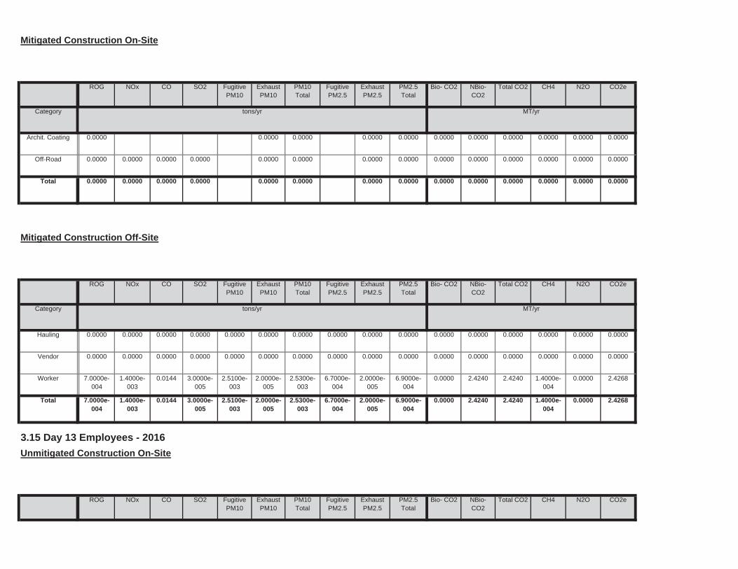
Total CO2 CH4 N2O CO2ePM10Total
FugitivePM2.5
ExhaustPM2.5
PM2.5Total
Bio- CO2 NBio- CO2
3.15 Day 13 Employees - 2016
Unmitigated Construction On-Site
ROG NOx CO SO2 Fugitive PM10
ExhaustPM10
0.0000 2.4240 2.4240 1.4000e-004
0.0000 2.42682.5100e-003
2.0000e-005
2.5300e-003
6.7000e-004
2.0000e-005
6.9000e-004
Total 7.0000e-004
1.4000e-003
0.0144 3.0000e-005
0.0000 2.4240 2.4240 1.4000e-004
0.0000 2.42682.5100e-003
2.0000e-005
2.5300e-003
6.7000e-004
2.0000e-005
6.9000e-004
Worker 7.0000e-004
1.4000e-003
0.0144 3.0000e-005
0.0000 0.0000 0.0000 0.0000 0.0000 0.00000.0000 0.0000 0.0000 0.0000 0.0000 0.0000Vendor 0.0000 0.0000 0.0000 0.0000
0.0000 0.0000 0.0000 0.0000 0.0000 0.00000.0000 0.0000 0.0000 0.0000 0.0000 0.0000Hauling 0.0000 0.0000 0.0000 0.0000
Total CO2 CH4 N2O CO2e
Category tons/yr MT/yr
PM10Total
FugitivePM2.5
ExhaustPM2.5
PM2.5Total
Bio- CO2 NBio- CO2
Mitigated Construction Off-Site
ROG NOx CO SO2 Fugitive PM10
ExhaustPM10
0.0000 0.0000 0.0000 0.0000 0.0000 0.00000.0000 0.0000 0.0000 0.0000Total 0.0000 0.0000 0.0000 0.0000
0.0000 0.0000 0.0000 0.0000 0.0000 0.00000.0000 0.0000 0.0000 0.0000Off-Road 0.0000 0.0000 0.0000 0.0000
0.0000 0.0000 0.0000 0.0000 0.0000 0.00000.0000 0.0000 0.0000 0.0000Archit. Coating 0.0000
Total CO2 CH4 N2O CO2e
Category tons/yr MT/yr
PM10Total
FugitivePM2.5
ExhaustPM2.5
PM2.5Total
Bio- CO2 NBio- CO2
Mitigated Construction On-Site
ROG NOx CO SO2 Fugitive PM10
ExhaustPM10
0.0000 2.4240 2.4240 1.4000e-004
0.0000 2.42682.5100e-003
2.0000e-005
2.5300e-003
6.7000e-004
2.0000e-005
6.9000e-004
Total 7.0000e-004
1.4000e-003
0.0144 3.0000e-005
0.0000 2.4240 2.4240 1.4000e-004
0.0000 2.42682.5100e-003
2.0000e-005
2.5300e-003
6.7000e-004
2.0000e-005
6.9000e-004
Worker 7.0000e-004
1.4000e-003
0.0144 3.0000e-005
0.0000 0.0000 0.0000 0.0000 0.0000 0.00000.0000 0.0000 0.0000 0.0000 0.0000 0.0000Vendor 0.0000 0.0000 0.0000 0.0000
0.0000 0.0000 0.0000 0.0000 0.0000 0.00000.0000 0.0000 0.0000 0.0000 0.0000 0.0000Hauling 0.0000 0.0000 0.0000 0.0000
Total CO2 CH4 N2O CO2e
Category tons/yr MT/yr
PM10Total
FugitivePM2.5
ExhaustPM2.5
PM2.5Total
Bio- CO2 NBio- CO2
Unmitigated Construction Off-Site
ROG NOx CO SO2 Fugitive PM10
ExhaustPM10
0.0000 0.0000 0.0000 0.0000 0.0000 0.00000.0000 0.0000 0.0000 0.0000Total 0.0000 0.0000 0.0000 0.0000
0.0000 0.0000 0.0000 0.0000 0.0000 0.00000.0000 0.0000 0.0000 0.0000Off-Road 0.0000 0.0000 0.0000 0.0000
0.0000 0.0000 0.0000 0.0000 0.0000 0.00000.0000 0.0000 0.0000 0.0000Archit. Coating 0.0000
Category tons/yr MT/yr

Unmitigated Construction Off-Site
0.0000 0.0000 0.0000 0.0000 0.0000 0.00000.0000 0.0000 0.0000 0.0000Total 0.0000 0.0000 0.0000 0.0000
0.0000 0.0000 0.0000 0.0000 0.0000 0.00000.0000 0.0000 0.0000 0.0000Off-Road 0.0000 0.0000 0.0000 0.0000
0.0000 0.0000 0.0000 0.0000 0.0000 0.00000.0000 0.0000 0.0000 0.0000Archit. Coating 0.0000
Total CO2 CH4 N2O CO2e
Category tons/yr MT/yr
PM10Total
FugitivePM2.5
ExhaustPM2.5
PM2.5Total
Bio- CO2 NBio- CO2
3.16 Day 14 Employees - 2016
Unmitigated Construction On-Site
ROG NOx CO SO2 Fugitive PM10
ExhaustPM10
0.0000 2.4240 2.4240 1.4000e-004
0.0000 2.42682.5100e-003
2.0000e-005
2.5300e-003
6.7000e-004
2.0000e-005
6.9000e-004
Total 7.0000e-004
1.4000e-003
0.0144 3.0000e-005
0.0000 2.4240 2.4240 1.4000e-004
0.0000 2.42682.5100e-003
2.0000e-005
2.5300e-003
6.7000e-004
2.0000e-005
6.9000e-004
Worker 7.0000e-004
1.4000e-003
0.0144 3.0000e-005
0.0000 0.0000 0.0000 0.0000 0.0000 0.00000.0000 0.0000 0.0000 0.0000 0.0000 0.0000Vendor 0.0000 0.0000 0.0000 0.0000
0.0000 0.0000 0.0000 0.0000 0.0000 0.00000.0000 0.0000 0.0000 0.0000 0.0000 0.0000Hauling 0.0000 0.0000 0.0000 0.0000
Total CO2 CH4 N2O CO2e
Category tons/yr MT/yr
PM10Total
FugitivePM2.5
ExhaustPM2.5
PM2.5Total
Bio- CO2 NBio- CO2
Mitigated Construction Off-Site
ROG NOx CO SO2 Fugitive PM10
ExhaustPM10
0.0000 0.0000 0.0000 0.0000 0.0000 0.00000.0000 0.0000 0.0000 0.0000Total 0.0000 0.0000 0.0000 0.0000
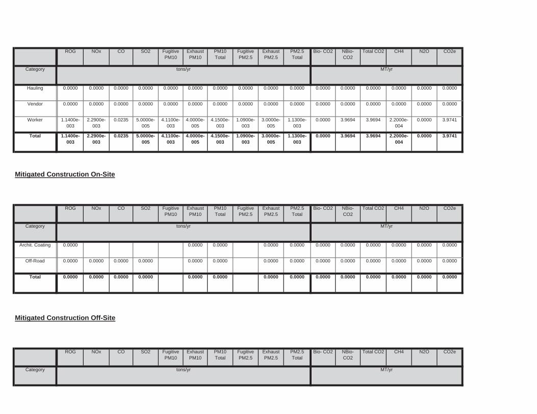
Total CO2 CH4 N2O CO2e
Category tons/yr MT/yr
PM10Total
FugitivePM2.5
ExhaustPM2.5
PM2.5Total
Bio- CO2 NBio- CO2
Mitigated Construction Off-Site
ROG NOx CO SO2 Fugitive PM10
ExhaustPM10
0.0000 0.0000 0.0000 0.0000 0.0000 0.00000.0000 0.0000 0.0000 0.0000Total 0.0000 0.0000 0.0000 0.0000
0.0000 0.0000 0.0000 0.0000 0.0000 0.00000.0000 0.0000 0.0000 0.0000Off-Road 0.0000 0.0000 0.0000 0.0000
0.0000 0.0000 0.0000 0.0000 0.0000 0.00000.0000 0.0000 0.0000 0.0000Archit. Coating 0.0000
Total CO2 CH4 N2O CO2e
Category tons/yr MT/yr
PM10Total
FugitivePM2.5
ExhaustPM2.5
PM2.5Total
Bio- CO2 NBio- CO2
Mitigated Construction On-Site
ROG NOx CO SO2 Fugitive PM10
ExhaustPM10
0.0000 3.9694 3.9694 2.2000e-004
0.0000 3.97414.1100e-003
4.0000e-005
4.1500e-003
1.0900e-003
3.0000e-005
1.1300e-003
Total 1.1400e-003
2.2900e-003
0.0235 5.0000e-005
0.0000 3.9694 3.9694 2.2000e-004
0.0000 3.97414.1100e-003
4.0000e-005
4.1500e-003
1.0900e-003
3.0000e-005
1.1300e-003
Worker 1.1400e-003
2.2900e-003
0.0235 5.0000e-005
0.0000 0.0000 0.0000 0.0000 0.0000 0.00000.0000 0.0000 0.0000 0.0000 0.0000 0.0000Vendor 0.0000 0.0000 0.0000 0.0000
0.0000 0.0000 0.0000 0.0000 0.0000 0.00000.0000 0.0000 0.0000 0.0000 0.0000 0.0000Hauling 0.0000 0.0000 0.0000 0.0000
Total CO2 CH4 N2O CO2e
Category tons/yr MT/yr
PM10Total
FugitivePM2.5
ExhaustPM2.5
PM2.5Total
Bio- CO2 NBio- CO2
ROG NOx CO SO2 Fugitive PM10
ExhaustPM10

0.0000 3.5248 3.5248 2.0000e-004
0.0000 3.52903.6500e-003
3.0000e-005
3.6800e-003
9.7000e-004
3.0000e-005
1.0000e-003
Worker 1.0100e-003
2.0400e-003
0.0209 5.0000e-005
0.0000 0.0000 0.0000 0.0000 0.0000 0.00000.0000 0.0000 0.0000 0.0000 0.0000 0.0000Vendor 0.0000 0.0000 0.0000 0.0000
0.0000 0.0000 0.0000 0.0000 0.0000 0.00000.0000 0.0000 0.0000 0.0000 0.0000 0.0000Hauling 0.0000 0.0000 0.0000 0.0000
Total CO2 CH4 N2O CO2e
Category tons/yr MT/yr
PM10Total
FugitivePM2.5
ExhaustPM2.5
PM2.5Total
Bio- CO2 NBio- CO2
Unmitigated Construction Off-Site
ROG NOx CO SO2 Fugitive PM10
ExhaustPM10
0.0000 0.0000 0.0000 0.0000 0.0000 0.00000.0000 0.0000 0.0000 0.0000Total 0.0000 0.0000 0.0000 0.0000
0.0000 0.0000 0.0000 0.0000 0.0000 0.00000.0000 0.0000 0.0000 0.0000Off-Road 0.0000 0.0000 0.0000 0.0000
0.0000 0.0000 0.0000 0.0000 0.0000 0.00000.0000 0.0000 0.0000 0.0000Archit. Coating 0.0000
Total CO2 CH4 N2O CO2e
Category tons/yr MT/yr
PM10Total
FugitivePM2.5
ExhaustPM2.5
PM2.5Total
Bio- CO2 NBio- CO2
3.17 Day 18 Employees - 2016
Unmitigated Construction On-Site
ROG NOx CO SO2 Fugitive PM10
ExhaustPM10
0.0000 3.9694 3.9694 2.2000e-004
0.0000 3.97414.1100e-003
4.0000e-005
4.1500e-003
1.0900e-003
3.0000e-005
1.1300e-003
Total 1.1400e-003
2.2900e-003
0.0235 5.0000e-005
0.0000 3.9694 3.9694 2.2000e-004
0.0000 3.97414.1100e-003
4.0000e-005
4.1500e-003
1.0900e-003
3.0000e-005
1.1300e-003
Worker 1.1400e-003
2.2900e-003
0.0235 5.0000e-005
0.0000 0.0000 0.0000 0.0000 0.0000 0.00000.0000 0.0000 0.0000 0.0000 0.0000 0.0000Vendor 0.0000 0.0000 0.0000 0.0000
0.0000 0.0000 0.0000 0.0000 0.0000 0.00000.0000 0.0000 0.0000 0.0000 0.0000 0.0000Hauling 0.0000 0.0000 0.0000 0.0000

3.18 Day 19 Employees - 2016
Unmitigated Construction On-Site
0.0000 3.5248 3.5248 2.0000e-004
0.0000 3.52903.6500e-003
3.0000e-005
3.6800e-003
9.7000e-004
3.0000e-005
1.0000e-003
Total 1.0100e-003
2.0400e-003
0.0209 5.0000e-005
0.0000 3.5248 3.5248 2.0000e-004
0.0000 3.52903.6500e-003
3.0000e-005
3.6800e-003
9.7000e-004
3.0000e-005
1.0000e-003
Worker 1.0100e-003
2.0400e-003
0.0209 5.0000e-005
0.0000 0.0000 0.0000 0.0000 0.0000 0.00000.0000 0.0000 0.0000 0.0000 0.0000 0.0000Vendor 0.0000 0.0000 0.0000 0.0000
0.0000 0.0000 0.0000 0.0000 0.0000 0.00000.0000 0.0000 0.0000 0.0000 0.0000 0.0000Hauling 0.0000 0.0000 0.0000 0.0000
Total CO2 CH4 N2O CO2e
Category tons/yr MT/yr
PM10Total
FugitivePM2.5
ExhaustPM2.5
PM2.5Total
Bio- CO2 NBio- CO2
Mitigated Construction Off-Site
ROG NOx CO SO2 Fugitive PM10
ExhaustPM10
0.0000 0.0000 0.0000 0.0000 0.0000 0.00000.0000 0.0000 0.0000 0.0000Total 0.0000 0.0000 0.0000 0.0000
0.0000 0.0000 0.0000 0.0000 0.0000 0.00000.0000 0.0000 0.0000 0.0000Off-Road 0.0000 0.0000 0.0000 0.0000
0.0000 0.0000 0.0000 0.0000 0.0000 0.00000.0000 0.0000 0.0000 0.0000Archit. Coating 0.0000
Total CO2 CH4 N2O CO2e
Category tons/yr MT/yr
PM10Total
FugitivePM2.5
ExhaustPM2.5
PM2.5Total
Bio- CO2 NBio- CO2
Mitigated Construction On-Site
ROG NOx CO SO2 Fugitive PM10
ExhaustPM10
0.0000 3.5248 3.5248 2.0000e-004
0.0000 3.52903.6500e-003
3.0000e-005
3.6800e-003
9.7000e-004
3.0000e-005
1.0000e-003
Total 1.0100e-003
2.0400e-003
0.0209 5.0000e-005
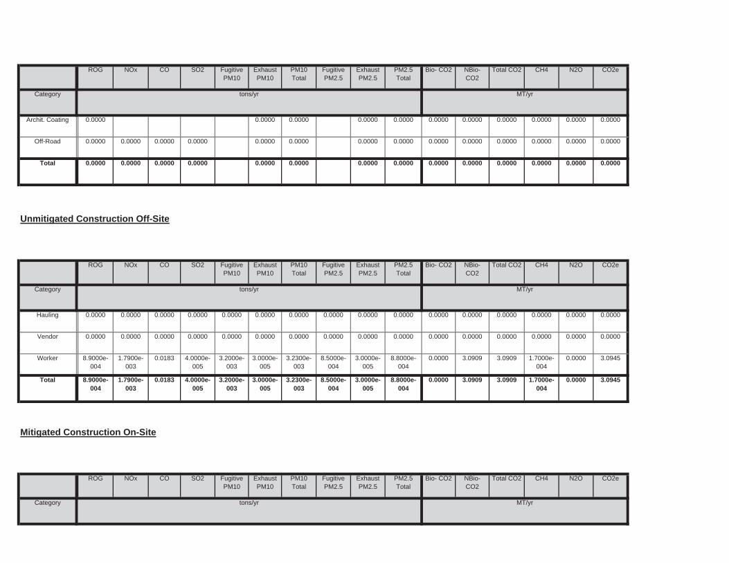
Total CO2 CH4 N2O CO2e
Category tons/yr MT/yr
PM10Total
FugitivePM2.5
ExhaustPM2.5
PM2.5Total
Bio- CO2 NBio- CO2
Mitigated Construction On-Site
ROG NOx CO SO2 Fugitive PM10
ExhaustPM10
0.0000 3.0909 3.0909 1.7000e-004
0.0000 3.09453.2000e-003
3.0000e-005
3.2300e-003
8.5000e-004
3.0000e-005
8.8000e-004
Total 8.9000e-004
1.7900e-003
0.0183 4.0000e-005
0.0000 3.0909 3.0909 1.7000e-004
0.0000 3.09453.2000e-003
3.0000e-005
3.2300e-003
8.5000e-004
3.0000e-005
8.8000e-004
Worker 8.9000e-004
1.7900e-003
0.0183 4.0000e-005
0.0000 0.0000 0.0000 0.0000 0.0000 0.00000.0000 0.0000 0.0000 0.0000 0.0000 0.0000Vendor 0.0000 0.0000 0.0000 0.0000
0.0000 0.0000 0.0000 0.0000 0.0000 0.00000.0000 0.0000 0.0000 0.0000 0.0000 0.0000Hauling 0.0000 0.0000 0.0000 0.0000
Total CO2 CH4 N2O CO2e
Category tons/yr MT/yr
PM10Total
FugitivePM2.5
ExhaustPM2.5
PM2.5Total
Bio- CO2 NBio- CO2
Unmitigated Construction Off-Site
ROG NOx CO SO2 Fugitive PM10
ExhaustPM10
0.0000 0.0000 0.0000 0.0000 0.0000 0.00000.0000 0.0000 0.0000 0.0000Total 0.0000 0.0000 0.0000 0.0000
0.0000 0.0000 0.0000 0.0000 0.0000 0.00000.0000 0.0000 0.0000 0.0000Off-Road 0.0000 0.0000 0.0000 0.0000
0.0000 0.0000 0.0000 0.0000 0.0000 0.00000.0000 0.0000 0.0000 0.0000Archit. Coating 0.0000
Total CO2 CH4 N2O CO2e
Category tons/yr MT/yr
PM10Total
FugitivePM2.5
ExhaustPM2.5
PM2.5Total
Bio- CO2 NBio- CO2
ROG NOx CO SO2 Fugitive PM10
ExhaustPM10
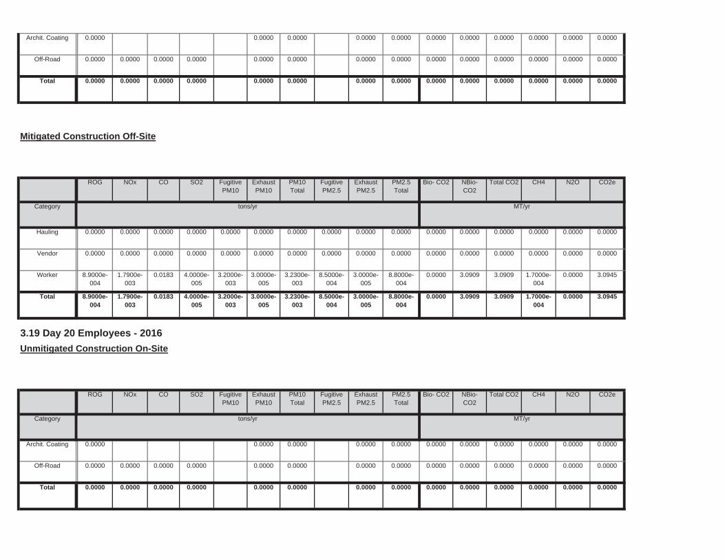
0.0000 0.0000 0.0000 0.0000 0.0000 0.00000.0000 0.0000 0.0000 0.0000Total 0.0000 0.0000 0.0000 0.0000
0.0000 0.0000 0.0000 0.0000 0.0000 0.00000.0000 0.0000 0.0000 0.0000Off-Road 0.0000 0.0000 0.0000 0.0000
0.0000 0.0000 0.0000 0.0000 0.0000 0.00000.0000 0.0000 0.0000 0.0000Archit. Coating 0.0000
Total CO2 CH4 N2O CO2e
Category tons/yr MT/yr
PM10Total
FugitivePM2.5
ExhaustPM2.5
PM2.5Total
Bio- CO2 NBio- CO2
3.19 Day 20 Employees - 2016
Unmitigated Construction On-Site
ROG NOx CO SO2 Fugitive PM10
ExhaustPM10
0.0000 3.0909 3.0909 1.7000e-004
0.0000 3.09453.2000e-003
3.0000e-005
3.2300e-003
8.5000e-004
3.0000e-005
8.8000e-004
Total 8.9000e-004
1.7900e-003
0.0183 4.0000e-005
0.0000 3.0909 3.0909 1.7000e-004
0.0000 3.09453.2000e-003
3.0000e-005
3.2300e-003
8.5000e-004
3.0000e-005
8.8000e-004
Worker 8.9000e-004
1.7900e-003
0.0183 4.0000e-005
0.0000 0.0000 0.0000 0.0000 0.0000 0.00000.0000 0.0000 0.0000 0.0000 0.0000 0.0000Vendor 0.0000 0.0000 0.0000 0.0000
0.0000 0.0000 0.0000 0.0000 0.0000 0.00000.0000 0.0000 0.0000 0.0000 0.0000 0.0000Hauling 0.0000 0.0000 0.0000 0.0000
Total CO2 CH4 N2O CO2e
Category tons/yr MT/yr
PM10Total
FugitivePM2.5
ExhaustPM2.5
PM2.5Total
Bio- CO2 NBio- CO2
Mitigated Construction Off-Site
ROG NOx CO SO2 Fugitive PM10
ExhaustPM10
0.0000 0.0000 0.0000 0.0000 0.0000 0.00000.0000 0.0000 0.0000 0.0000Total 0.0000 0.0000 0.0000 0.0000
0.0000 0.0000 0.0000 0.0000 0.0000 0.00000.0000 0.0000 0.0000 0.0000Off-Road 0.0000 0.0000 0.0000 0.0000
0.0000 0.0000 0.0000 0.0000 0.0000 0.00000.0000 0.0000 0.0000 0.0000Archit. Coating 0.0000
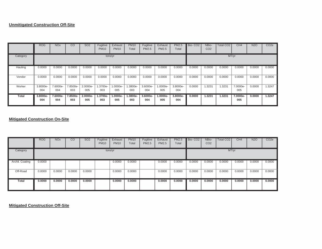
Mitigated Construction Off-Site
0.0000 0.0000 0.0000 0.0000 0.0000 0.00000.0000 0.0000 0.0000 0.0000Total 0.0000 0.0000 0.0000 0.0000
0.0000 0.0000 0.0000 0.0000 0.0000 0.00000.0000 0.0000 0.0000 0.0000Off-Road 0.0000 0.0000 0.0000 0.0000
0.0000 0.0000 0.0000 0.0000 0.0000 0.00000.0000 0.0000 0.0000 0.0000Archit. Coating 0.0000
Total CO2 CH4 N2O CO2e
Category tons/yr MT/yr
PM10Total
FugitivePM2.5
ExhaustPM2.5
PM2.5Total
Bio- CO2 NBio- CO2
Mitigated Construction On-Site
ROG NOx CO SO2 Fugitive PM10
ExhaustPM10
0.0000 1.3231 1.3231 7.0000e-005
0.0000 1.32471.3700e-003
1.0000e-005
1.3800e-003
3.6000e-004
1.0000e-005
3.8000e-004
Total 3.8000e-004
7.6000e-004
7.8500e-003
2.0000e-005
0.0000 1.3231 1.3231 7.0000e-005
0.0000 1.32471.3700e-003
1.0000e-005
1.3800e-003
3.6000e-004
1.0000e-005
3.8000e-004
Worker 3.8000e-004
7.6000e-004
7.8500e-003
2.0000e-005
0.0000 0.0000 0.0000 0.0000 0.0000 0.00000.0000 0.0000 0.0000 0.0000 0.0000 0.0000Vendor 0.0000 0.0000 0.0000 0.0000
0.0000 0.0000 0.0000 0.0000 0.0000 0.00000.0000 0.0000 0.0000 0.0000 0.0000 0.0000Hauling 0.0000 0.0000 0.0000 0.0000
Total CO2 CH4 N2O CO2e
Category tons/yr MT/yr
PM10Total
FugitivePM2.5
ExhaustPM2.5
PM2.5Total
Bio- CO2 NBio- CO2
Unmitigated Construction Off-Site
ROG NOx CO SO2 Fugitive PM10
ExhaustPM10
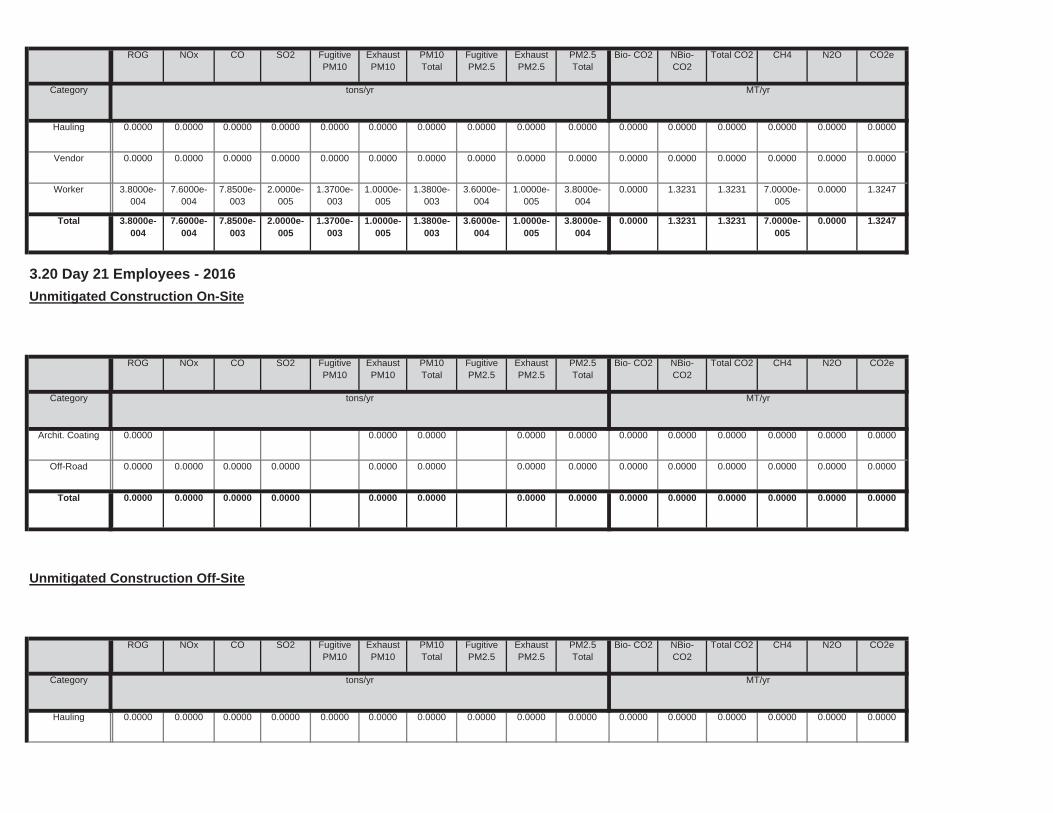
0.0000 0.0000 0.0000 0.0000 0.0000 0.00000.0000 0.0000 0.0000 0.0000Total 0.0000 0.0000 0.0000 0.0000
0.0000 0.0000 0.0000 0.0000 0.0000 0.00000.0000 0.0000 0.0000 0.0000Off-Road 0.0000 0.0000 0.0000 0.0000
0.0000 0.0000 0.0000 0.0000 0.0000 0.00000.0000 0.0000 0.0000 0.0000Archit. Coating 0.0000
Total CO2 CH4 N2O CO2e
Category tons/yr MT/yr
PM10Total
FugitivePM2.5
ExhaustPM2.5
PM2.5Total
Bio- CO2 NBio- CO2
3.20 Day 21 Employees - 2016
Unmitigated Construction On-Site
ROG NOx CO SO2 Fugitive PM10
ExhaustPM10
0.0000 1.3231 1.3231 7.0000e-005
0.0000 1.32471.3700e-003
1.0000e-005
1.3800e-003
3.6000e-004
1.0000e-005
3.8000e-004
Total 3.8000e-004
7.6000e-004
7.8500e-003
2.0000e-005
0.0000 1.3231 1.3231 7.0000e-005
0.0000 1.32471.3700e-003
1.0000e-005
1.3800e-003
3.6000e-004
1.0000e-005
3.8000e-004
Worker 3.8000e-004
7.6000e-004
7.8500e-003
2.0000e-005
0.0000 0.0000 0.0000 0.0000 0.0000 0.00000.0000 0.0000 0.0000 0.0000 0.0000 0.0000Vendor 0.0000 0.0000 0.0000 0.0000
0.0000 0.0000 0.0000 0.0000 0.0000 0.00000.0000 0.0000 0.0000 0.0000 0.0000 0.0000Hauling 0.0000 0.0000 0.0000 0.0000
Total CO2 CH4 N2O CO2e
Category tons/yr MT/yr
PM10Total
FugitivePM2.5
ExhaustPM2.5
PM2.5Total
Bio- CO2 NBio- CO2
ROG NOx CO SO2 Fugitive PM10
ExhaustPM10

0.0000 0.6669 0.6669 4.0000e-005
0.0000 0.66766.9000e-004
1.0000e-005
7.0000e-004
1.8000e-004
1.0000e-005
1.9000e-004
Total 1.9000e-004
3.9000e-004
3.9600e-003
1.0000e-005
0.0000 0.6669 0.6669 4.0000e-005
0.0000 0.66766.9000e-004
1.0000e-005
7.0000e-004
1.8000e-004
1.0000e-005
1.9000e-004
Worker 1.9000e-004
3.9000e-004
3.9600e-003
1.0000e-005
0.0000 0.0000 0.0000 0.0000 0.0000 0.00000.0000 0.0000 0.0000 0.0000 0.0000 0.0000Vendor 0.0000 0.0000 0.0000 0.0000
0.0000 0.0000 0.0000 0.0000 0.0000 0.00000.0000 0.0000 0.0000 0.0000 0.0000 0.0000Hauling 0.0000 0.0000 0.0000 0.0000
Total CO2 CH4 N2O CO2e
Category tons/yr MT/yr
PM10Total
FugitivePM2.5
ExhaustPM2.5
PM2.5Total
Bio- CO2 NBio- CO2
Mitigated Construction Off-Site
ROG NOx CO SO2 Fugitive PM10
ExhaustPM10
0.0000 0.0000 0.0000 0.0000 0.0000 0.00000.0000 0.0000 0.0000 0.0000Total 0.0000 0.0000 0.0000 0.0000
0.0000 0.0000 0.0000 0.0000 0.0000 0.00000.0000 0.0000 0.0000 0.0000Off-Road 0.0000 0.0000 0.0000 0.0000
0.0000 0.0000 0.0000 0.0000 0.0000 0.00000.0000 0.0000 0.0000 0.0000Archit. Coating 0.0000
Total CO2 CH4 N2O CO2e
Category tons/yr MT/yr
PM10Total
FugitivePM2.5
ExhaustPM2.5
PM2.5Total
Bio- CO2 NBio- CO2
Mitigated Construction On-Site
ROG NOx CO SO2 Fugitive PM10
ExhaustPM10
0.0000 0.6669 0.6669 4.0000e-005
0.0000 0.66766.9000e-004
1.0000e-005
7.0000e-004
1.8000e-004
1.0000e-005
1.9000e-004
Total 1.9000e-004
3.9000e-004
3.9600e-003
1.0000e-005
0.0000 0.6669 0.6669 4.0000e-005
0.0000 0.66766.9000e-004
1.0000e-005
7.0000e-004
1.8000e-004
1.0000e-005
1.9000e-004
Worker 1.9000e-004
3.9000e-004
3.9600e-003
1.0000e-005
0.0000 0.0000 0.0000 0.0000 0.0000 0.00000.0000 0.0000 0.0000 0.0000 0.0000 0.0000Vendor 0.0000 0.0000 0.0000 0.0000
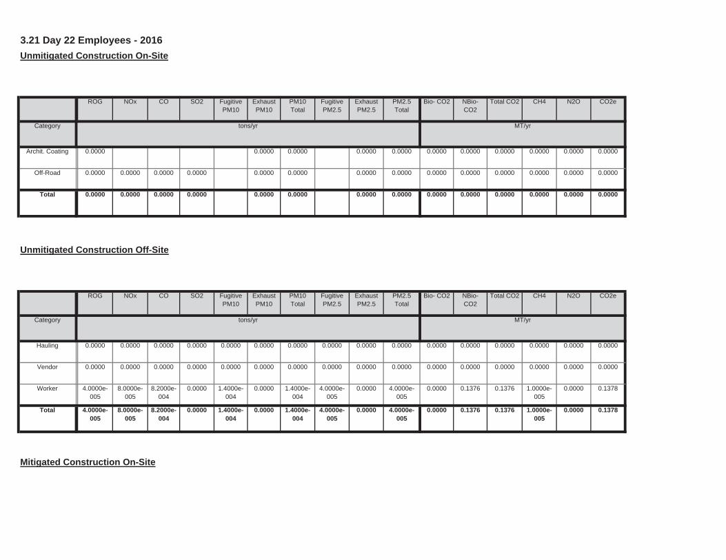
Mitigated Construction On-Site
0.0000 0.1376 0.1376 1.0000e-005
0.0000 0.13781.4000e-004
0.0000 1.4000e-004
4.0000e-005
0.0000 4.0000e-005
Total 4.0000e-005
8.0000e-005
8.2000e-004
0.0000
0.0000 0.1376 0.1376 1.0000e-005
0.0000 0.13781.4000e-004
0.0000 1.4000e-004
4.0000e-005
0.0000 4.0000e-005
Worker 4.0000e-005
8.0000e-005
8.2000e-004
0.0000
0.0000 0.0000 0.0000 0.0000 0.0000 0.00000.0000 0.0000 0.0000 0.0000 0.0000 0.0000Vendor 0.0000 0.0000 0.0000 0.0000
0.0000 0.0000 0.0000 0.0000 0.0000 0.00000.0000 0.0000 0.0000 0.0000 0.0000 0.0000Hauling 0.0000 0.0000 0.0000 0.0000
Total CO2 CH4 N2O CO2e
Category tons/yr MT/yr
PM10Total
FugitivePM2.5
ExhaustPM2.5
PM2.5Total
Bio- CO2 NBio- CO2
Unmitigated Construction Off-Site
ROG NOx CO SO2 Fugitive PM10
ExhaustPM10
0.0000 0.0000 0.0000 0.0000 0.0000 0.00000.0000 0.0000 0.0000 0.0000Total 0.0000 0.0000 0.0000 0.0000
0.0000 0.0000 0.0000 0.0000 0.0000 0.00000.0000 0.0000 0.0000 0.0000Off-Road 0.0000 0.0000 0.0000 0.0000
0.0000 0.0000 0.0000 0.0000 0.0000 0.00000.0000 0.0000 0.0000 0.0000Archit. Coating 0.0000
Total CO2 CH4 N2O CO2e
Category tons/yr MT/yr
PM10Total
FugitivePM2.5
ExhaustPM2.5
PM2.5Total
Bio- CO2 NBio- CO2
3.21 Day 22 Employees - 2016
Unmitigated Construction On-Site
ROG NOx CO SO2 Fugitive PM10
ExhaustPM10
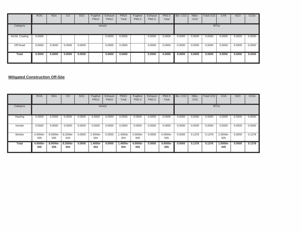
0.0000 0.1376 0.1376 1.0000e-005
0.0000 0.13781.4000e-004
0.0000 1.4000e-004
4.0000e-005
0.0000 4.0000e-005
Total 4.0000e-005
8.0000e-005
8.2000e-004
0.0000
0.0000 0.1376 0.1376 1.0000e-005
0.0000 0.13781.4000e-004
0.0000 1.4000e-004
4.0000e-005
0.0000 4.0000e-005
Worker 4.0000e-005
8.0000e-005
8.2000e-004
0.0000
0.0000 0.0000 0.0000 0.0000 0.0000 0.00000.0000 0.0000 0.0000 0.0000 0.0000 0.0000Vendor 0.0000 0.0000 0.0000 0.0000
0.0000 0.0000 0.0000 0.0000 0.0000 0.00000.0000 0.0000 0.0000 0.0000 0.0000 0.0000Hauling 0.0000 0.0000 0.0000 0.0000
Total CO2 CH4 N2O CO2e
Category tons/yr MT/yr
PM10Total
FugitivePM2.5
ExhaustPM2.5
PM2.5Total
Bio- CO2 NBio- CO2
Mitigated Construction Off-Site
ROG NOx CO SO2 Fugitive PM10
ExhaustPM10
0.0000 0.0000 0.0000 0.0000 0.0000 0.00000.0000 0.0000 0.0000 0.0000Total 0.0000 0.0000 0.0000 0.0000
0.0000 0.0000 0.0000 0.0000 0.0000 0.00000.0000 0.0000 0.0000 0.0000Off-Road 0.0000 0.0000 0.0000 0.0000
0.0000 0.0000 0.0000 0.0000 0.0000 0.00000.0000 0.0000 0.0000 0.0000Archit. Coating 0.0000
Total CO2 CH4 N2O CO2e
Category tons/yr MT/yr
PM10Total
FugitivePM2.5
ExhaustPM2.5
PM2.5Total
Bio- CO2 NBio- CO2
ROG NOx CO SO2 Fugitive PM10
ExhaustPM10
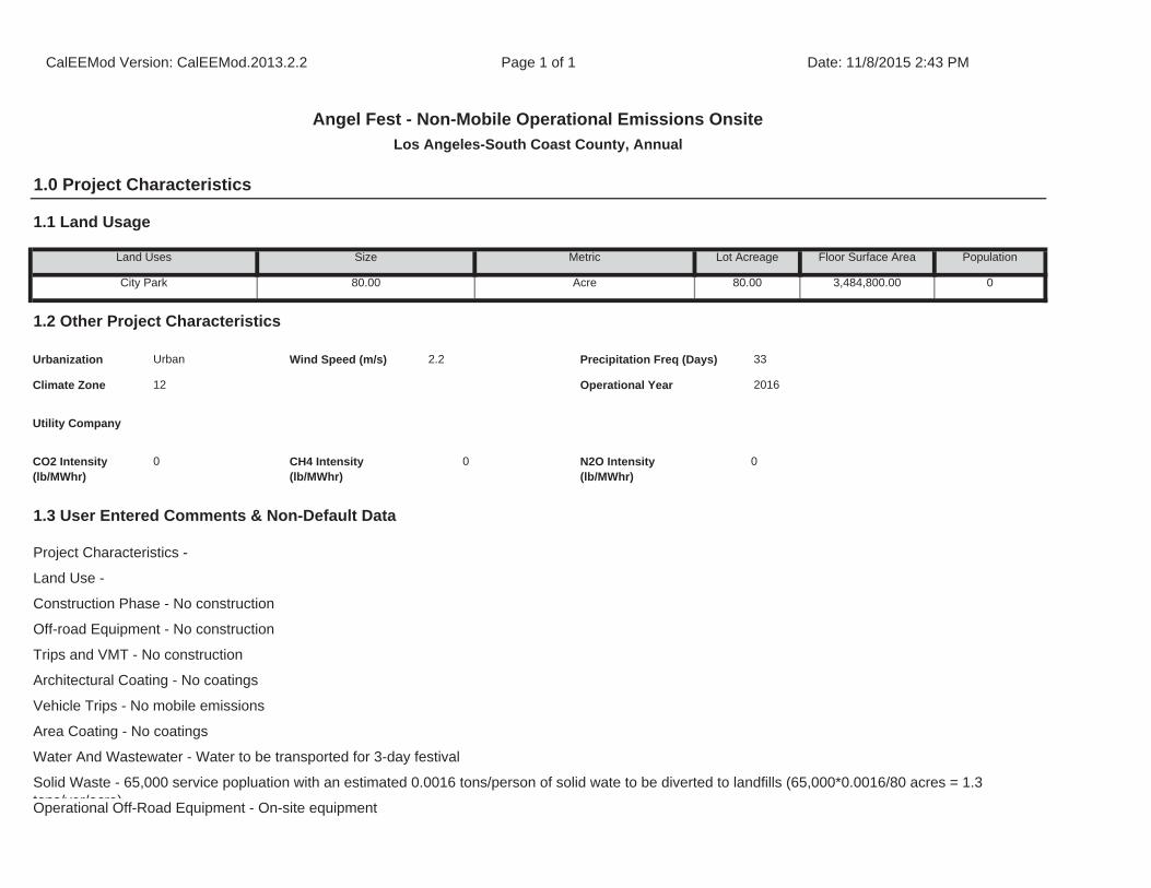
Architectural Coating - No coatings
Vehicle Trips - No mobile emissions
Area Coating - No coatings
Water And Wastewater - Water to be transported for 3-day festival
Solid Waste - 65,000 service popluation with an estimated 0.0016 tons/person of solid wate to be diverted to landfills (65,000*0.0016/80 acres = 1.3 tons/yer/acre)Operational Off-Road Equipment - On-site equipment
1.3 User Entered Comments & Non-Default Data
Project Characteristics -
Land Use -
Construction Phase - No construction
Off-road Equipment - No construction
Trips and VMT - No construction
CO2 Intensity (lb/MWhr)
0 CH4 Intensity (lb/MWhr)
0 N2O Intensity (lb/MWhr)
0
33
Climate Zone 12 Operational Year 2016
Utility Company
1.2 Other Project Characteristics
Urbanization Urban Wind Speed (m/s) 2.2 Precipitation Freq (Days)
Population
City Park 80.00 Acre 80.00 3,484,800.00 0
1.1 Land Usage
Land Uses Size Metric Lot Acreage Floor Surface Area
CalEEMod Version: CalEEMod.2013.2.2 Page 1 of 1 Date: 11/8/2015 2:43 PM
Angel Fest - Non-Mobile Operational Emissions Onsite
Los Angeles-South Coast County, Annual
1.0 Project Characteristics
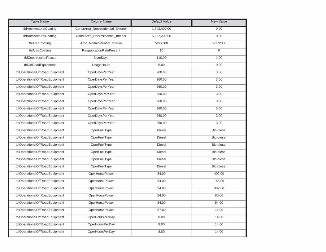
tblOperationalOffRoadEquipment OperHoursPerDay 8.00 14.00
tblOperationalOffRoadEquipment OperHoursPerDay 8.00 14.00
tblOperationalOffRoadEquipment OperHorsePower 87.00 11.00
tblOperationalOffRoadEquipment OperHoursPerDay 8.00 14.00
tblOperationalOffRoadEquipment OperHorsePower 84.00 80.00
tblOperationalOffRoadEquipment OperHorsePower 84.00 54.00
tblOperationalOffRoadEquipment OperHorsePower 84.00 168.00
tblOperationalOffRoadEquipment OperHorsePower 84.00 302.00
tblOperationalOffRoadEquipment OperFuelType Diesel Bio-diesel
tblOperationalOffRoadEquipment OperHorsePower 84.00 402.00
tblOperationalOffRoadEquipment OperFuelType Diesel Bio-diesel
tblOperationalOffRoadEquipment OperFuelType Diesel Bio-diesel
tblOperationalOffRoadEquipment OperFuelType Diesel Bio-diesel
tblOperationalOffRoadEquipment OperFuelType Diesel Bio-diesel
tblOperationalOffRoadEquipment OperDaysPerYear 260.00 3.00
tblOperationalOffRoadEquipment OperFuelType Diesel Bio-diesel
tblOperationalOffRoadEquipment OperDaysPerYear 260.00 3.00
tblOperationalOffRoadEquipment OperDaysPerYear 260.00 3.00
tblOperationalOffRoadEquipment OperDaysPerYear 260.00 3.00
tblOperationalOffRoadEquipment OperDaysPerYear 260.00 3.00
tblOperationalOffRoadEquipment OperDaysPerYear 260.00 3.00
tblOperationalOffRoadEquipment OperDaysPerYear 260.00 3.00
tblOffRoadEquipment UsageHours 6.00 0.00
tblOperationalOffRoadEquipment OperDaysPerYear 260.00 3.00
tblAreaCoating ReapplicationRatePercent 10 0
tblConstructionPhase NumDays 110.00 1.00
tblArchitecturalCoating ConstArea_Nonresidential_Interior 5,227,200.00 0.00
tblAreaCoating Area_Nonresidential_Interior 5227200 52272000
Table Name Column Name Default Value New Value
tblArchitecturalCoating ConstArea_Nonresidential_Exterior 1,742,400.00 0.00
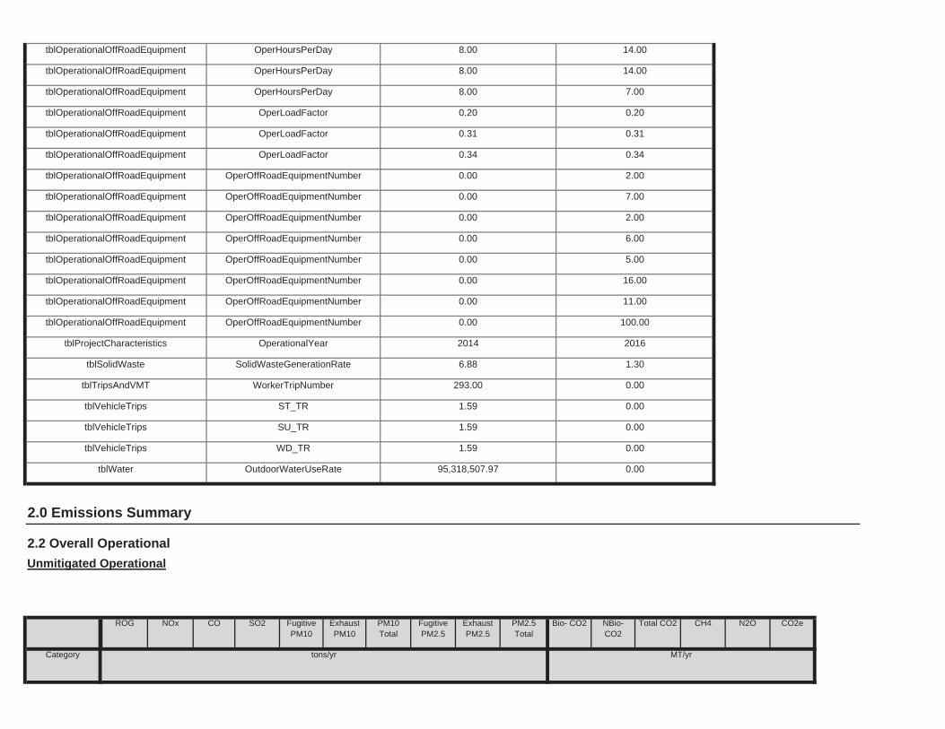
Total CO2 CH4 N2O CO2e
Category tons/yr MT/yr
PM10Total
FugitivePM2.5
ExhaustPM2.5
PM2.5Total
Bio- CO2 NBio- CO2
2.2 Overall Operational
Unmitigated Operational
ROG NOx CO SO2 Fugitive PM10
ExhaustPM10
tblWater OutdoorWaterUseRate 95,318,507.97 0.00
2.0 Emissions Summary
tblVehicleTrips SU_TR 1.59 0.00
tblVehicleTrips WD_TR 1.59 0.00
tblTripsAndVMT WorkerTripNumber 293.00 0.00
tblVehicleTrips ST_TR 1.59 0.00
tblProjectCharacteristics OperationalYear 2014 2016
tblSolidWaste SolidWasteGenerationRate 6.88 1.30
tblOperationalOffRoadEquipment OperOffRoadEquipmentNumber 0.00 11.00
tblOperationalOffRoadEquipment OperOffRoadEquipmentNumber 0.00 100.00
tblOperationalOffRoadEquipment OperOffRoadEquipmentNumber 0.00 5.00
tblOperationalOffRoadEquipment OperOffRoadEquipmentNumber 0.00 16.00
tblOperationalOffRoadEquipment OperOffRoadEquipmentNumber 0.00 2.00
tblOperationalOffRoadEquipment OperOffRoadEquipmentNumber 0.00 6.00
tblOperationalOffRoadEquipment OperOffRoadEquipmentNumber 0.00 2.00
tblOperationalOffRoadEquipment OperOffRoadEquipmentNumber 0.00 7.00
tblOperationalOffRoadEquipment OperLoadFactor 0.31 0.31
tblOperationalOffRoadEquipment OperLoadFactor 0.34 0.34
tblOperationalOffRoadEquipment OperHoursPerDay 8.00 7.00
tblOperationalOffRoadEquipment OperLoadFactor 0.20 0.20
tblOperationalOffRoadEquipment OperHoursPerDay 8.00 14.00
tblOperationalOffRoadEquipment OperHoursPerDay 8.00 14.00
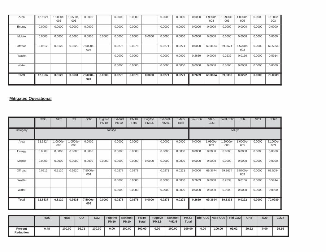
0.00 100.00 99.62 29.62 0.00 99.150.00 100.00 100.00 0.00 100.00 100.00
NBio-CO2 Total CO2 CH4 N20 CO2e
PercentReduction
0.48 100.00 99.71 100.00
ExhaustPM10
PM10Total
FugitivePM2.5
ExhaustPM2.5
PM2.5Total
Bio- CO2ROG NOx CO SO2 Fugitive PM10
0.2639 69.3694 69.6333 0.0222 0.0000 70.09890.0000 0.0278 0.0278 0.0000 0.0271 0.0271Total 12.6537 0.5120 0.3631 7.5000e-004
0.0000 0.0000 0.0000 0.0000 0.0000 0.00000.0000 0.0000 0.0000 0.0000Water
0.2639 0.0000 0.2639 0.0156 0.0000 0.59140.0000 0.0000 0.0000 0.0000Waste
0.0000 69.3674 69.3674 6.5700e-003
0.0000 69.50540.0278 0.0278 0.0271 0.0271Offroad 0.0612 0.5120 0.3620 7.5000e-004
0.0000 0.0000 0.0000 0.0000 0.0000 0.00000.0000 0.0000 0.0000 0.0000 0.0000 0.0000Mobile 0.0000 0.0000 0.0000 0.0000
0.0000 0.0000 0.0000 0.0000 0.0000 0.00000.0000 0.0000 0.0000 0.0000Energy 0.0000 0.0000 0.0000 0.0000
0.0000 1.9900e-003
1.9900e-003
1.0000e-005
0.0000 2.1000e-003
0.0000 0.0000 0.0000 0.0000Area 12.5924 1.0000e-005
1.0500e-003
0.0000
Total CO2 CH4 N2O CO2e
Category tons/yr MT/yr
PM10Total
FugitivePM2.5
ExhaustPM2.5
PM2.5Total
Bio- CO2 NBio- CO2
Mitigated Operational
ROG NOx CO SO2 Fugitive PM10
ExhaustPM10
0.2639 69.3694 69.6333 0.0222 0.0000 70.09890.0000 0.0278 0.0278 0.0000 0.0271 0.0271Total 12.6537 0.5120 0.3631 7.5000e-004
0.0000 0.0000 0.0000 0.0000 0.0000 0.00000.0000 0.0000 0.0000 0.0000Water
0.2639 0.0000 0.2639 0.0156 0.0000 0.59140.0000 0.0000 0.0000 0.0000Waste
0.0000 69.3674 69.3674 6.5700e-003
0.0000 69.50540.0278 0.0278 0.0271 0.0271Offroad 0.0612 0.5120 0.3620 7.5000e-004
0.0000 0.0000 0.0000 0.0000 0.0000 0.00000.0000 0.0000 0.0000 0.0000 0.0000 0.0000Mobile 0.0000 0.0000 0.0000 0.0000
0.0000 0.0000 0.0000 0.0000 0.0000 0.00000.0000 0.0000 0.0000 0.0000Energy 0.0000 0.0000 0.0000 0.0000
0.0000 1.9900e-003
1.9900e-003
1.0000e-005
0.0000 2.1000e-003
0.0000 0.0000 0.0000 0.0000Area 12.5924 1.0000e-005
1.0500e-003
0.0000
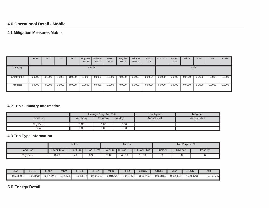
0.002453 0.003157 0.003691 0.000543 0.001655
5.0 Energy Detail
SBUS MH
0.533598 0.058434 0.178244 0.125508 0.038944 0.006283 0.016425 0.031066
LHD2 MHD HHD OBUS UBUS MCY
48.00 19.00 66 28 6
LDA LDT1 LDT2 MDV LHD1
H-S or C-C H-O or C-NW Primary Diverted Pass-by
City Park 16.60 8.40 6.90 33.00
4.3 Trip Type Information
Miles Trip % Trip Purpose %
Land Use H-W or C-W H-S or C-C H-O or C-NW H-W or C-W
Total 0.00 0.00 0.00
Annual VMT
City Park 0.00 0.00 0.00
4.2 Trip Summary Information
Average Daily Trip Rate Unmitigated Mitigated
Land Use Weekday Saturday Sunday Annual VMT
0.0000 0.0000 0.0000 0.0000 0.0000 0.00000.0000 0.0000 0.0000 0.0000 0.0000 0.0000Mitigated 0.0000 0.0000 0.0000 0.0000
0.0000 0.0000 0.0000 0.0000 0.0000 0.00000.0000 0.0000 0.0000 0.0000 0.0000 0.0000Unmitigated 0.0000 0.0000 0.0000 0.0000
NBio-CO2
Total CO2 CH4 N2O CO2e
Category tons/yr MT/yr
ExhaustPM10
PM10Total
FugitivePM2.5
ExhaustPM2.5
PM2.5Total
Bio- CO2
4.0 Operational Detail - Mobile
4.1 Mitigation Measures Mobile
ROG NOx CO SO2 Fugitive PM10
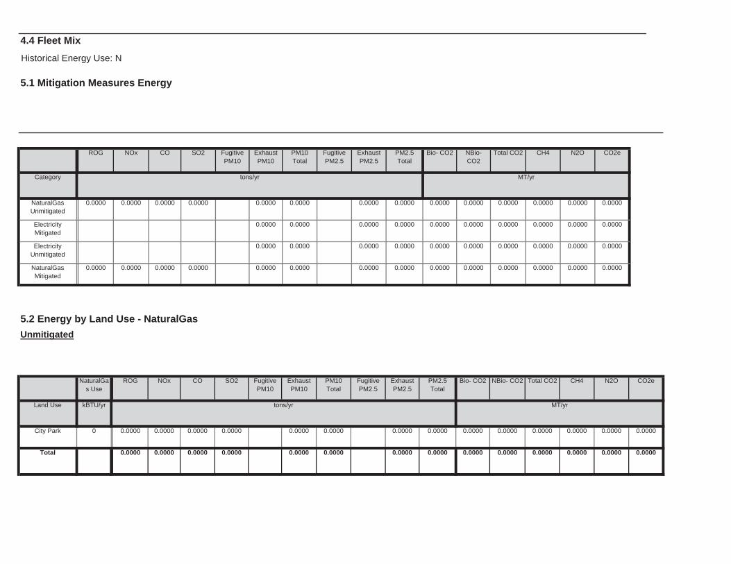
0.0000 0.0000 0.0000 0.00000.0000 0.0000 0.0000 0.0000 0.0000
0.0000
Total 0.0000 0.0000 0.0000 0.0000 0.0000
0.0000 0.0000 0.0000 0.0000 0.0000 0.00000.0000 0.0000 0.0000 0.0000City Park 0 0.0000 0.0000 0.0000
NBio- CO2 Total CO2 CH4 N2O CO2e
Land Use kBTU/yr tons/yr MT/yr
ExhaustPM10
PM10Total
FugitivePM2.5
ExhaustPM2.5
PM2.5Total
Bio- CO2
5.2 Energy by Land Use - NaturalGas
Unmitigated
NaturalGas Use
ROG NOx CO SO2 Fugitive PM10
0.0000 0.0000 0.0000 0.0000 0.0000 0.00000.0000 0.0000 0.0000 0.0000NaturalGasMitigated
0.0000 0.0000 0.0000 0.0000
0.0000 0.0000 0.0000 0.0000 0.0000 0.00000.0000 0.0000 0.0000 0.0000ElectricityUnmitigated
0.0000 0.0000 0.0000 0.0000 0.0000 0.00000.0000 0.0000 0.0000 0.0000ElectricityMitigated
0.0000 0.0000 0.0000 0.0000 0.0000 0.00000.0000 0.0000 0.0000 0.0000NaturalGasUnmitigated
0.0000 0.0000 0.0000 0.0000
NBio-CO2
Total CO2 CH4 N2O CO2e
Category tons/yr MT/yr
ExhaustPM10
PM10Total
FugitivePM2.5
ExhaustPM2.5
PM2.5Total
Bio- CO2
4.4 Fleet Mix
Historical Energy Use: N
5.1 Mitigation Measures Energy
ROG NOx CO SO2 Fugitive PM10
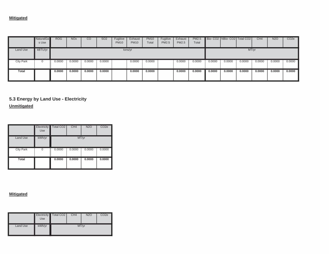
Land Use kWh/yr ton
MT/yr
Mitigated
ElectricityUse
Total CO2 CH4 N2O CO2e
0.0000
Total 0.0000 0.0000 0.0000 0.0000
Land Use kWh/yr ton
MT/yr
City Park 0 0.0000 0.0000 0.0000
Unmitigated
ElectricityUse
Total CO2 CH4 N2O CO2e
0.0000 0.0000 0.0000 0.0000 0.0000
5.3 Energy by Land Use - Electricity
0.0000 0.0000 0.0000 0.0000 0.0000
0.0000 0.0000
Total 0.0000 0.0000 0.0000 0.0000
0.0000 0.0000 0.0000 0.0000 0.0000 0.00000.0000 0.0000 0.0000 0.0000
CO2e
Land Use kBTU/yr tons/yr MT/yr
City Park 0 0.0000 0.0000
PM2.5Total
Bio- CO2 NBio- CO2 Total CO2 CH4 N2OSO2 Fugitive PM10
ExhaustPM10
PM10Total
FugitivePM2.5
ExhaustPM2.5
NaturalGas Use
ROG NOx CO
Mitigated
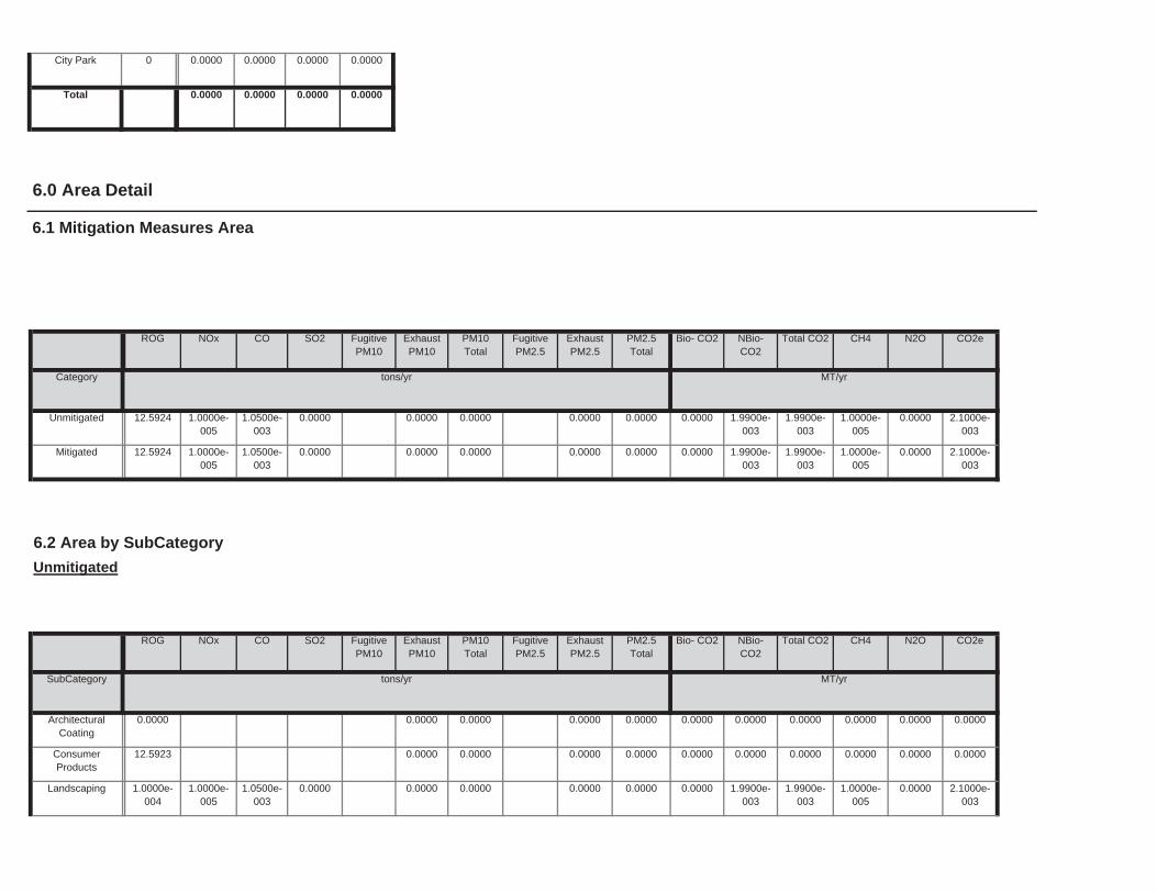
0.0000 1.9900e-003
1.9900e-003
1.0000e-005
0.0000 2.1000e-003
0.0000 0.0000 0.0000 0.0000Landscaping 1.0000e-004
1.0000e-005
1.0500e-003
0.0000
0.0000 0.0000 0.0000 0.0000 0.0000 0.00000.0000 0.0000 0.0000 0.0000ConsumerProducts
12.5923
0.0000 0.0000 0.0000 0.0000 0.0000 0.00000.0000 0.0000 0.0000 0.0000ArchitecturalCoating
0.0000
Total CO2 CH4 N2O CO2e
SubCategory tons/yr MT/yr
PM10Total
FugitivePM2.5
ExhaustPM2.5
PM2.5Total
Bio- CO2 NBio- CO2
6.2 Area by SubCategory
Unmitigated
ROG NOx CO SO2 Fugitive PM10
ExhaustPM10
0.0000 1.9900e-003
1.9900e-003
1.0000e-005
0.0000 2.1000e-003
0.0000 0.0000 0.0000 0.0000Mitigated 12.5924 1.0000e-005
1.0500e-003
0.0000
0.0000 1.9900e-003
1.9900e-003
1.0000e-005
0.0000 2.1000e-003
0.0000 0.0000 0.0000 0.0000Unmitigated 12.5924 1.0000e-005
1.0500e-003
0.0000
NBio-CO2
Total CO2 CH4 N2O CO2e
Category tons/yr MT/yr
ExhaustPM10
PM10Total
FugitivePM2.5
ExhaustPM2.5
PM2.5Total
Bio- CO2
6.0 Area Detail
6.1 Mitigation Measures Area
ROG NOx CO SO2 Fugitive PM10
0.0000
Total 0.0000 0.0000 0.0000 0.0000
City Park 0 0.0000 0.0000 0.0000
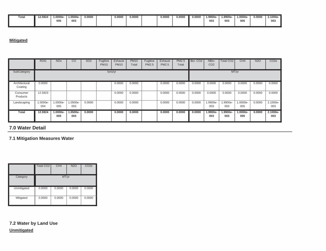
7.2 Water by Land Use
Unmitigated
Mitigated 0.0000 0.0000 0.0000 0.0000
Category ton
MT/yr
Unmitigated 0.0000 0.0000 0.0000 0.0000
7.0 Water Detail
7.1 Mitigation Measures Water
Total CO2 CH4 N2O CO2e
0.0000 1.9900e-003
1.9900e-003
1.0000e-005
0.0000 2.1000e-003
0.0000 0.0000 0.0000 0.0000Total 12.5924 1.0000e-005
1.0500e-003
0.0000
0.0000 1.9900e-003
1.9900e-003
1.0000e-005
0.0000 2.1000e-003
0.0000 0.0000 0.0000 0.0000Landscaping 1.0000e-004
1.0000e-005
1.0500e-003
0.0000
0.0000 0.0000 0.0000 0.0000 0.0000 0.00000.0000 0.0000 0.0000 0.0000ConsumerProducts
12.5923
0.0000 0.0000 0.0000 0.0000 0.0000 0.00000.0000 0.0000 0.0000 0.0000ArchitecturalCoating
0.0000
Total CO2 CH4 N2O CO2e
SubCategory tons/yr MT/yr
PM10Total
FugitivePM2.5
ExhaustPM2.5
PM2.5Total
Bio- CO2 NBio- CO2
Mitigated
ROG NOx CO SO2 Fugitive PM10
ExhaustPM10
0.0000 1.9900e-003
1.9900e-003
1.0000e-005
0.0000 2.1000e-003
0.0000 0.0000 0.0000 0.0000Total 12.5924 1.0000e-005
1.0500e-003
0.0000
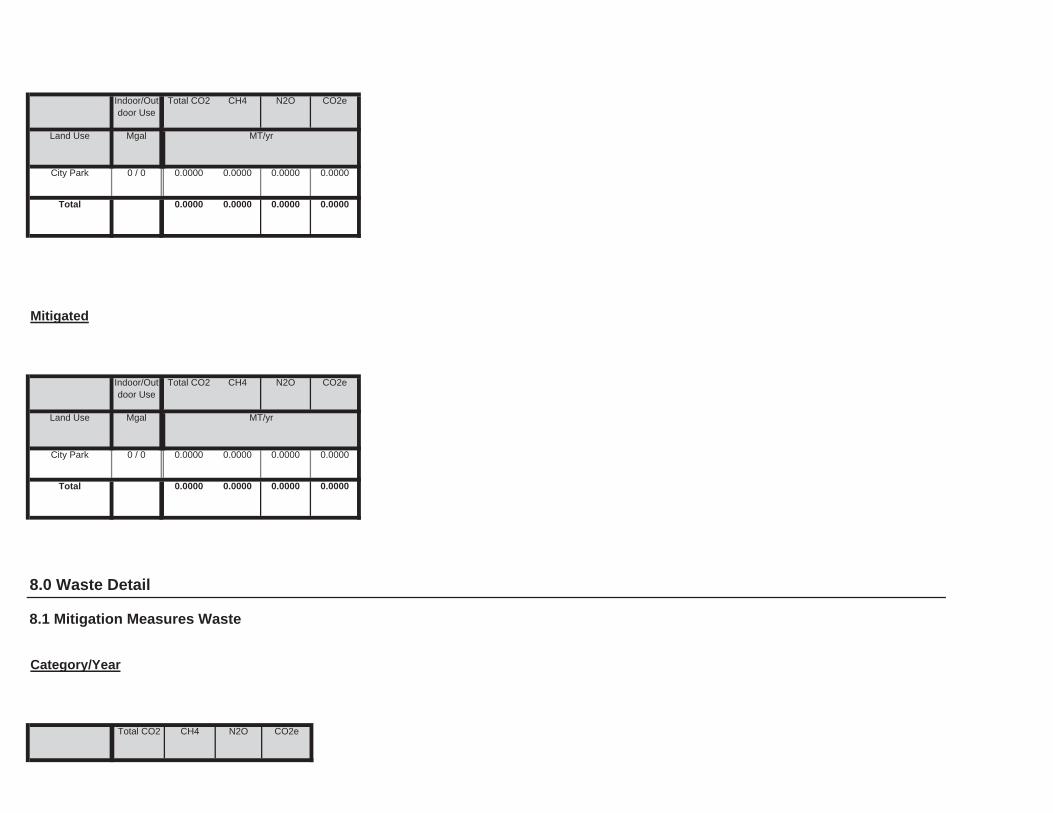
8.0 Waste Detail
8.1 Mitigation Measures Waste
Category/Year
Total CO2 CH4 N2O CO2e
0.0000
Total 0.0000 0.0000 0.0000 0.0000
Land Use Mgal ton
MT/yr
City Park 0 / 0 0.0000 0.0000 0.0000
Mitigated
Indoor/Outdoor Use
Total CO2 CH4 N2O CO2e
0.0000
Total 0.0000 0.0000 0.0000 0.0000
Land Use Mgal ton
MT/yr
City Park 0 / 0 0.0000 0.0000 0.0000
Indoor/Outdoor Use
Total CO2 CH4 N2O CO2e
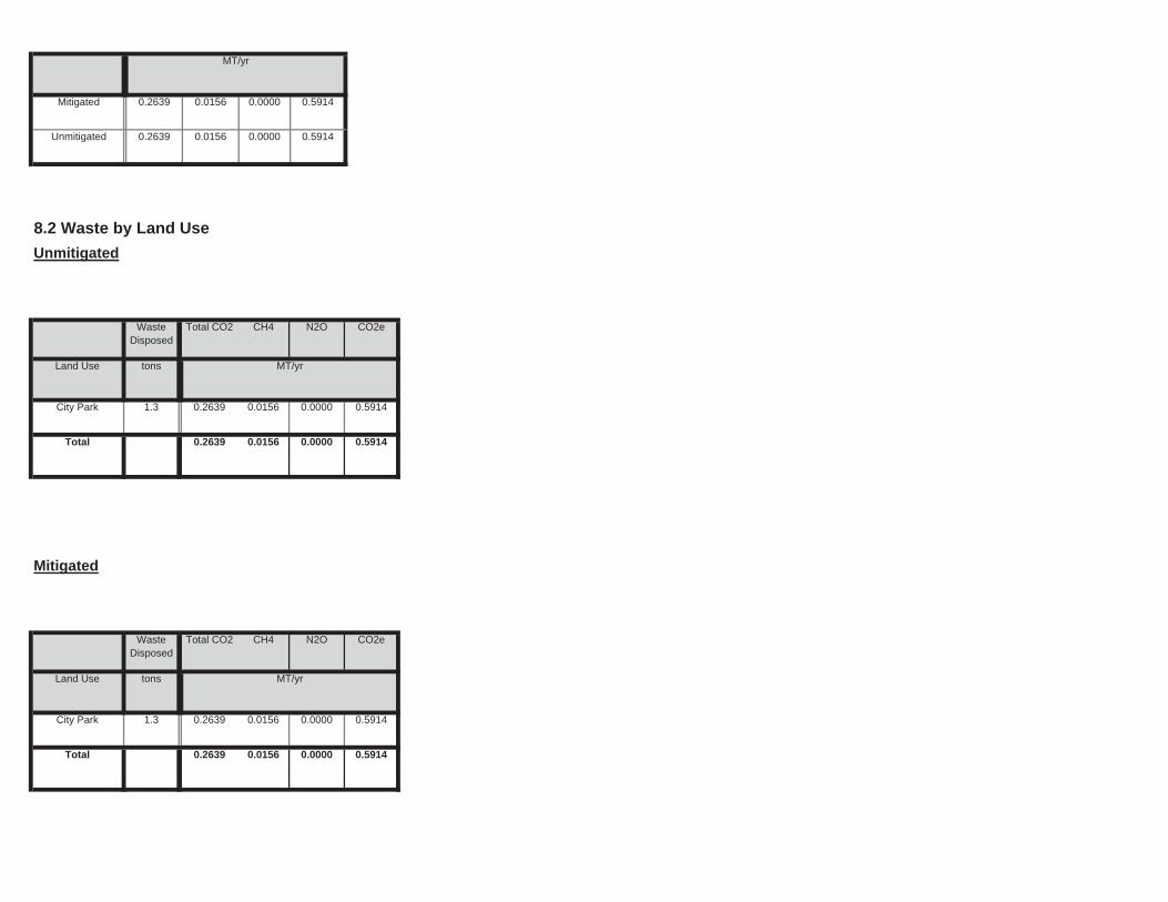
0.5914
Total 0.2639 0.0156 0.0000 0.5914
Land Use tons ton
MT/yr
City Park 1.3 0.2639 0.0156 0.0000
Mitigated
WasteDisposed
Total CO2 CH4 N2O CO2e
0.5914
Total 0.2639 0.0156 0.0000 0.5914
Land Use tons ton
MT/yr
City Park 1.3 0.2639 0.0156 0.0000
8.2 Waste by Land Use
Unmitigated
WasteDisposed
Total CO2 CH4 N2O CO2e
Unmitigated 0.2639 0.0156 0.0000 0.5914
ton
MT/yr
Mitigated 0.2639 0.0156 0.0000 0.5914
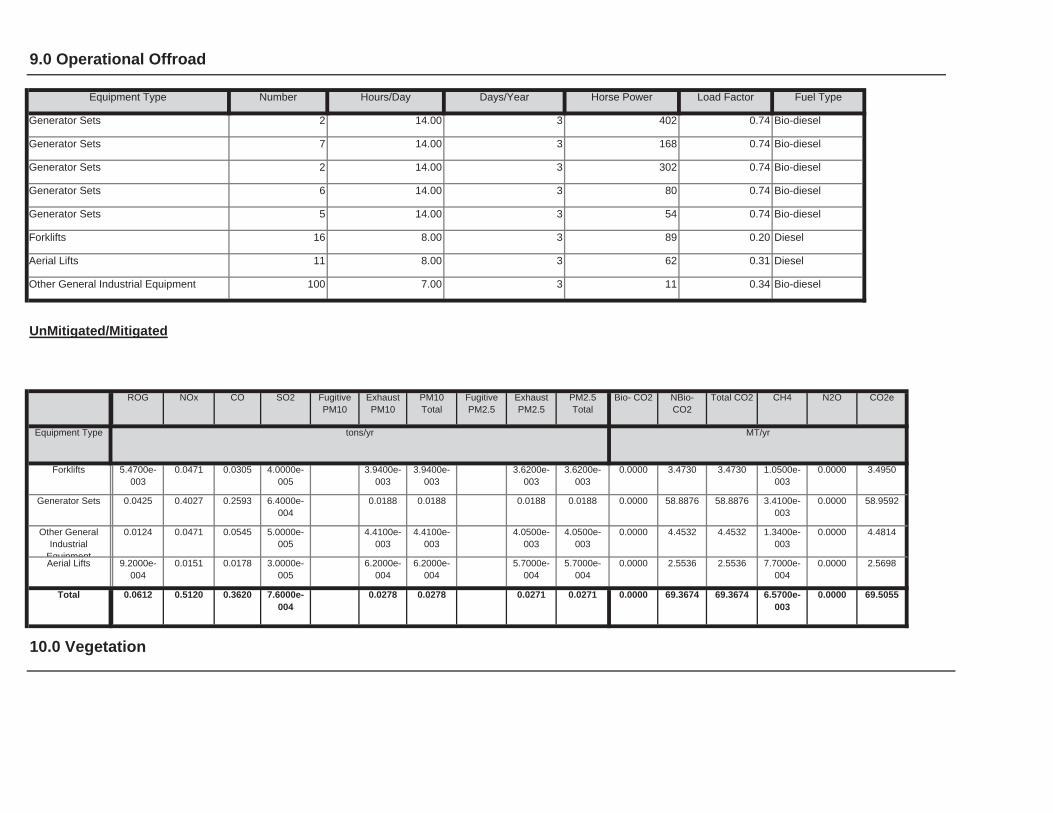
10.0 Vegetation
0.0000 69.3674 69.3674 6.5700e-003
0.0000 69.50550.0278 0.0278 0.0271 0.0271Total 0.0612 0.5120 0.3620 7.6000e-004
0.0000 2.5536 2.5536 7.7000e-004
0.0000 2.56986.2000e-004
6.2000e-004
5.7000e-004
5.7000e-004
Aerial Lifts 9.2000e-004
0.0151 0.0178 3.0000e-005
0.0000 4.4532 4.4532 1.3400e-003
0.0000 4.48144.4100e-003
4.4100e-003
4.0500e-003
4.0500e-003
Other General Industrial
Equipment
0.0124 0.0471 0.0545 5.0000e-005
0.0000 58.8876 58.8876 3.4100e-003
0.0000 58.95920.0188 0.0188 0.0188 0.0188Generator Sets 0.0425 0.4027 0.2593 6.4000e-004
0.0000 3.4730 3.4730 1.0500e-003
0.0000 3.49503.9400e-003
3.9400e-003
3.6200e-003
3.6200e-003
Forklifts 5.4700e-003
0.0471 0.0305 4.0000e-005
Total CO2 CH4 N2O CO2e
Equipment Type tons/yr MT/yr
PM10Total
FugitivePM2.5
ExhaustPM2.5
PM2.5Total
Bio- CO2 NBio- CO2
Bio-diesel
UnMitigated/Mitigated
ROG NOx CO SO2 Fugitive PM10
ExhaustPM10
Other General Industrial Equipment 100 7.00 3 11 0.34
Diesel
Aerial Lifts 11 8.00 3 62 0.31 Diesel
Forklifts 16 8.00 3 89 0.20
Bio-diesel
Generator Sets 5 14.00 3 54 0.74 Bio-diesel
Generator Sets 6 14.00 3 80 0.74
Bio-diesel
Generator Sets 2 14.00 3 302 0.74 Bio-diesel
Generator Sets 7 14.00 3 168 0.74
Load Factor Fuel Type
Generator Sets 2 14.00 3 402 0.74 Bio-diesel
9.0 Operational Offroad
Equipment Type Number Hours/Day Days/Year Horse Power
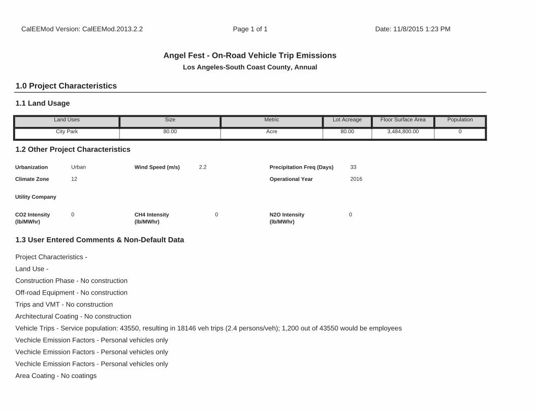
Architectural Coating - No construction
Vehicle Trips - Service population: 43550, resulting in 18146 veh trips (2.4 persons/veh); 1,200 out of 43550 would be employees
Vechicle Emission Factors - Personal vehicles only
Vechicle Emission Factors - Personal vehicles only
Vechicle Emission Factors - Personal vehicles only
Area Coating - No coatings
1.3 User Entered Comments & Non-Default Data
Project Characteristics -
Land Use -
Construction Phase - No construction
Off-road Equipment - No construction
Trips and VMT - No construction
CO2 Intensity (lb/MWhr)
0 CH4 Intensity (lb/MWhr)
0 N2O Intensity (lb/MWhr)
0
33
Climate Zone 12 Operational Year 2016
Utility Company
1.2 Other Project Characteristics
Urbanization Urban Wind Speed (m/s) 2.2 Precipitation Freq (Days)
Population
City Park 80.00 Acre 80.00 3,484,800.00 0
1.1 Land Usage
Land Uses Size Metric Lot Acreage Floor Surface Area
CalEEMod Version: CalEEMod.2013.2.2 Page 1 of 1 Date: 11/8/2015 1:23 PM
Angel Fest - On-Road Vehicle Trip Emissions
Los Angeles-South Coast County, Annual
1.0 Project Characteristics
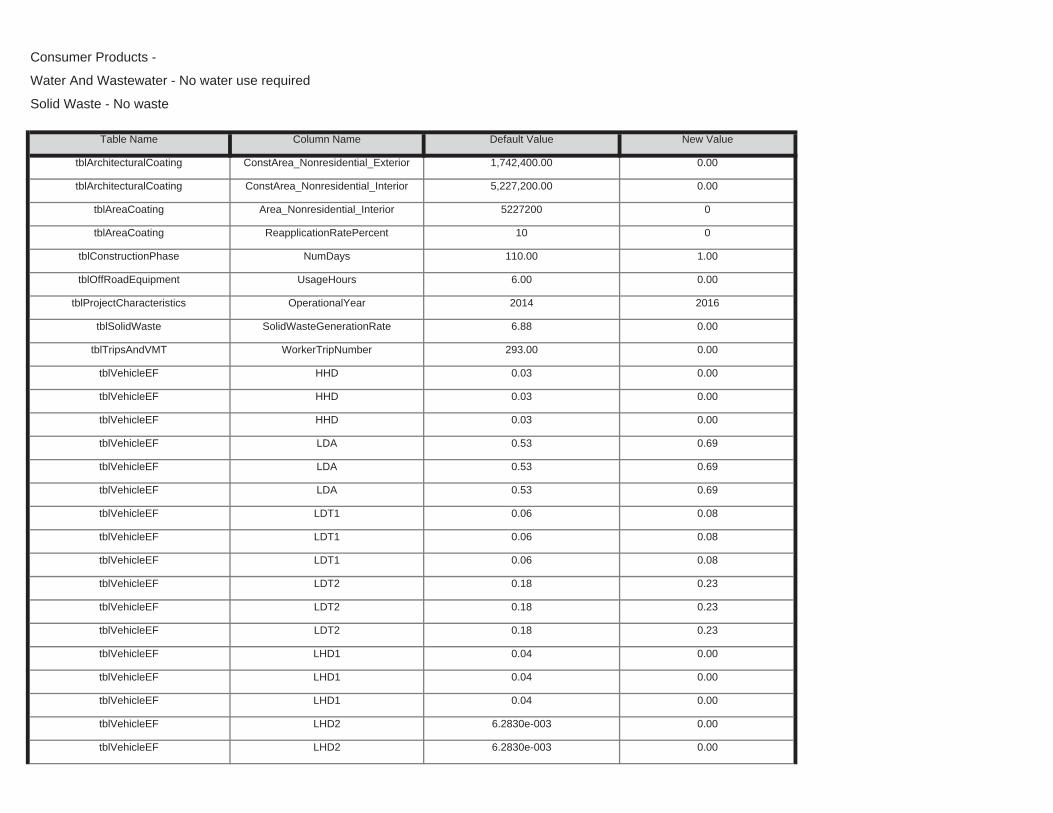
tblVehicleEF LHD2 6.2830e-003 0.00
tblVehicleEF LHD2 6.2830e-003 0.00
tblVehicleEF LHD1 0.04 0.00
tblVehicleEF LHD1 0.04 0.00
tblVehicleEF LDT2 0.18 0.23
tblVehicleEF LHD1 0.04 0.00
tblVehicleEF LDT2 0.18 0.23
tblVehicleEF LDT2 0.18 0.23
tblVehicleEF LDT1 0.06 0.08
tblVehicleEF LDT1 0.06 0.08
tblVehicleEF LDA 0.53 0.69
tblVehicleEF LDT1 0.06 0.08
tblVehicleEF LDA 0.53 0.69
tblVehicleEF LDA 0.53 0.69
tblVehicleEF HHD 0.03 0.00
tblVehicleEF HHD 0.03 0.00
tblTripsAndVMT WorkerTripNumber 293.00 0.00
tblVehicleEF HHD 0.03 0.00
tblProjectCharacteristics OperationalYear 2014 2016
tblSolidWaste SolidWasteGenerationRate 6.88 0.00
tblConstructionPhase NumDays 110.00 1.00
tblOffRoadEquipment UsageHours 6.00 0.00
tblAreaCoating Area_Nonresidential_Interior 5227200 0
tblAreaCoating ReapplicationRatePercent 10 0
tblArchitecturalCoating ConstArea_Nonresidential_Exterior 1,742,400.00 0.00
tblArchitecturalCoating ConstArea_Nonresidential_Interior 5,227,200.00 0.00
Consumer Products -
Water And Wastewater - No water use required
Solid Waste - No waste
Table Name Column Name Default Value New Value
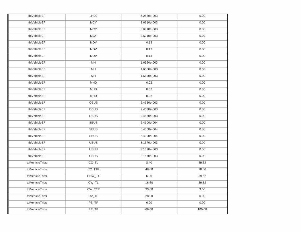
tblVehicleTrips PB_TP 6.00 0.00
tblVehicleTrips PR_TP 66.00 100.00
tblVehicleTrips CW_TTP 33.00 3.00
tblVehicleTrips DV_TP 28.00 0.00
tblVehicleTrips CNW_TL 6.90 59.52
tblVehicleTrips CW_TL 16.60 59.52
tblVehicleTrips CC_TL 8.40 59.52
tblVehicleTrips CC_TTP 48.00 78.00
tblVehicleEF UBUS 3.1570e-003 0.00
tblVehicleEF UBUS 3.1570e-003 0.00
tblVehicleEF SBUS 5.4300e-004 0.00
tblVehicleEF UBUS 3.1570e-003 0.00
tblVehicleEF SBUS 5.4300e-004 0.00
tblVehicleEF SBUS 5.4300e-004 0.00
tblVehicleEF OBUS 2.4530e-003 0.00
tblVehicleEF OBUS 2.4530e-003 0.00
tblVehicleEF MHD 0.02 0.00
tblVehicleEF OBUS 2.4530e-003 0.00
tblVehicleEF MHD 0.02 0.00
tblVehicleEF MHD 0.02 0.00
tblVehicleEF MH 1.6550e-003 0.00
tblVehicleEF MH 1.6550e-003 0.00
tblVehicleEF MDV 0.13 0.00
tblVehicleEF MH 1.6550e-003 0.00
tblVehicleEF MDV 0.13 0.00
tblVehicleEF MDV 0.13 0.00
tblVehicleEF MCY 3.6910e-003 0.00
tblVehicleEF MCY 3.6910e-003 0.00
tblVehicleEF LHD2 6.2830e-003 0.00
tblVehicleEF MCY 3.6910e-003 0.00
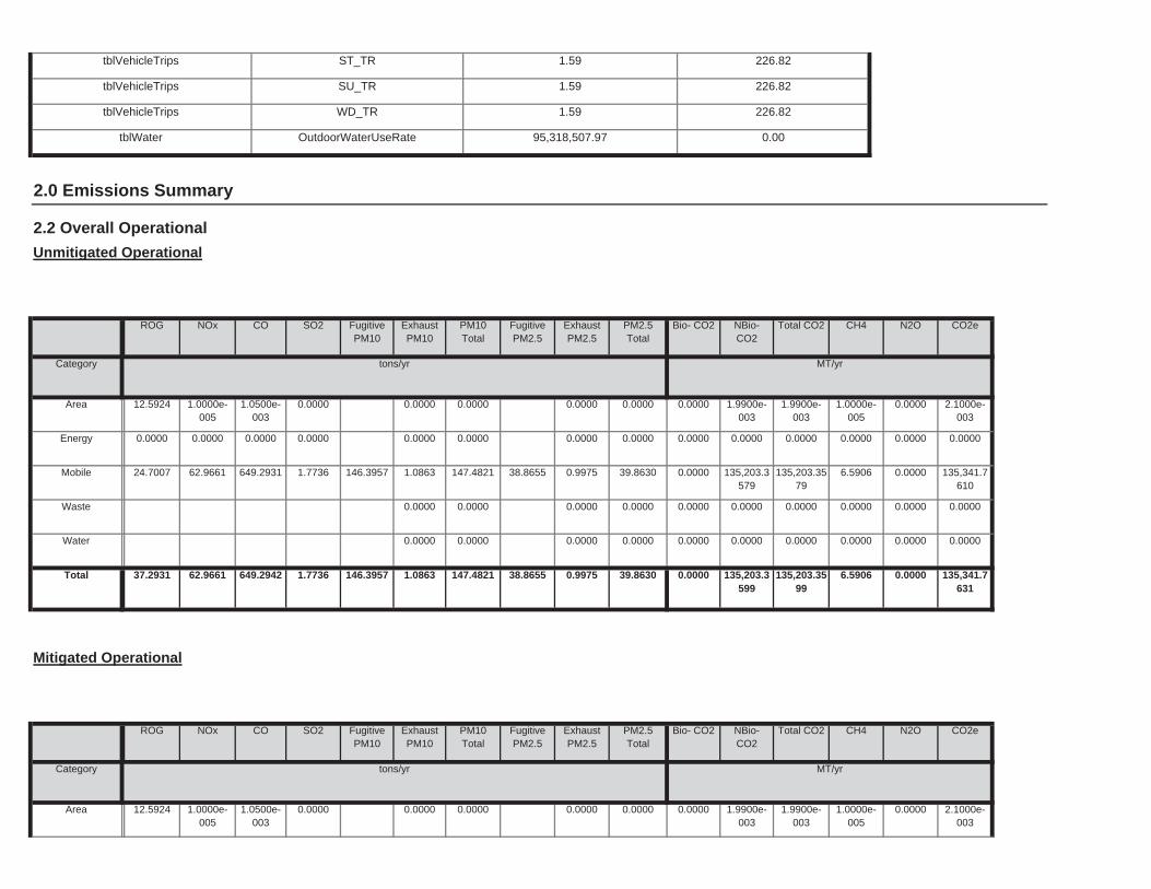
0.0000 1.9900e-003
1.9900e-003
1.0000e-005
0.0000 2.1000e-003
0.0000 0.0000 0.0000 0.0000Area 12.5924 1.0000e-005
1.0500e-003
0.0000
Total CO2 CH4 N2O CO2e
Category tons/yr MT/yr
PM10Total
FugitivePM2.5
ExhaustPM2.5
PM2.5Total
Bio- CO2 NBio- CO2
Mitigated Operational
ROG NOx CO SO2 Fugitive PM10
ExhaustPM10
0.0000 135,203.3599
135,203.3599
6.5906 0.0000 135,341.7631
146.3957 1.0863 147.4821 38.8655 0.9975 39.8630Total 37.2931 62.9661 649.2942 1.7736
0.0000 0.0000 0.0000 0.0000 0.0000 0.00000.0000 0.0000 0.0000 0.0000Water
0.0000 0.0000 0.0000 0.0000 0.0000 0.00000.0000 0.0000 0.0000 0.0000Waste
0.0000 135,203.3579
135,203.3579
6.5906 0.0000 135,341.7610
146.3957 1.0863 147.4821 38.8655 0.9975 39.8630Mobile 24.7007 62.9661 649.2931 1.7736
0.0000 0.0000 0.0000 0.0000 0.0000 0.00000.0000 0.0000 0.0000 0.0000Energy 0.0000 0.0000 0.0000 0.0000
0.0000 1.9900e-003
1.9900e-003
1.0000e-005
0.0000 2.1000e-003
0.0000 0.0000 0.0000 0.0000Area 12.5924 1.0000e-005
1.0500e-003
0.0000
Total CO2 CH4 N2O CO2e
Category tons/yr MT/yr
PM10Total
FugitivePM2.5
ExhaustPM2.5
PM2.5Total
Bio- CO2 NBio- CO2
2.2 Overall Operational
Unmitigated Operational
ROG NOx CO SO2 Fugitive PM10
ExhaustPM10
2.0 Emissions Summary
tblVehicleTrips WD_TR 1.59 226.82
tblWater OutdoorWaterUseRate 95,318,507.97 0.00
tblVehicleTrips ST_TR 1.59 226.82
tblVehicleTrips SU_TR 1.59 226.82
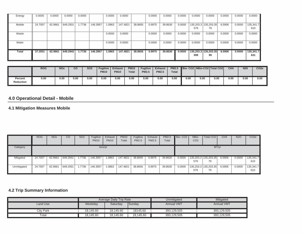
Total 18,145.60 18,145.60 18,145.60 393,129,505 393,129,505
Annual VMT
City Park 18,145.60 18,145.60 18145.60 393,129,505 393,129,505
4.2 Trip Summary Information
Average Daily Trip Rate Unmitigated Mitigated
Land Use Weekday Saturday Sunday Annual VMT
0.0000 135,203.3579
135,203.3579
6.5906 0.0000 135,341.7610
146.3957 1.0863 147.4821 38.8655 0.9975 39.8630Unmitigated 24.7007 62.9661 649.2931 1.7736
0.0000 135,203.3579
135,203.3579
6.5906 0.0000 135,341.7610
146.3957 1.0863 147.4821 38.8655 0.9975 39.8630Mitigated 24.7007 62.9661 649.2931 1.7736
NBio-CO2
Total CO2 CH4 N2O CO2e
Category tons/yr MT/yr
ExhaustPM10
PM10Total
FugitivePM2.5
ExhaustPM2.5
PM2.5Total
Bio- CO2
4.0 Operational Detail - Mobile
4.1 Mitigation Measures Mobile
ROG NOx CO SO2 Fugitive PM10
0.00 0.00 0.00 0.00 0.00 0.000.00 0.00 0.00 0.00 0.00 0.00
NBio-CO2 Total CO2 CH4 N20 CO2e
PercentReduction
0.00 0.00 0.00 0.00
ExhaustPM10
PM10Total
FugitivePM2.5
ExhaustPM2.5
PM2.5Total
Bio- CO2ROG NOx CO SO2 Fugitive PM10
0.0000 135,203.3599
135,203.3599
6.5906 0.0000 135,341.7631
146.3957 1.0863 147.4821 38.8655 0.9975 39.8630Total 37.2931 62.9661 649.2942 1.7736
0.0000 0.0000 0.0000 0.0000 0.0000 0.00000.0000 0.0000 0.0000 0.0000Water
0.0000 0.0000 0.0000 0.0000 0.0000 0.00000.0000 0.0000 0.0000 0.0000Waste
0.0000 135,203.3579
135,203.3579
6.5906 0.0000 135,341.7610
146.3957 1.0863 147.4821 38.8655 0.9975 39.8630Mobile 24.7007 62.9661 649.2931 1.7736
0.0000 0.0000 0.0000 0.0000 0.0000 0.00000.0000 0.0000 0.0000 0.0000Energy 0.0000 0.0000 0.0000 0.0000

5.2 Energy by Land Use - NaturalGas
Unmitigated
0.0000 0.0000 0.0000 0.0000 0.0000 0.00000.0000 0.0000 0.0000 0.0000NaturalGasUnmitigated
0.0000 0.0000 0.0000 0.0000
0.0000 0.0000 0.0000 0.0000 0.0000 0.00000.0000 0.0000 0.0000 0.0000NaturalGasMitigated
0.0000 0.0000 0.0000 0.0000
0.0000 0.0000 0.0000 0.0000 0.0000 0.00000.0000 0.0000 0.0000 0.0000ElectricityUnmitigated
0.0000 0.0000 0.0000 0.0000 0.0000 0.00000.0000 0.0000 0.0000 0.0000ElectricityMitigated
NBio-CO2
Total CO2 CH4 N2O CO2e
Category tons/yr MT/yr
ExhaustPM10
PM10Total
FugitivePM2.5
ExhaustPM2.5
PM2.5Total
Bio- CO2
4.4 Fleet Mix
Historical Energy Use: N
5.1 Mitigation Measures Energy
ROG NOx CO SO2 Fugitive PM10
0.000000 0.000000 0.000000 0.000000 0.000000
5.0 Energy Detail
SBUS MH
0.690000 0.080000 0.230000 0.000000 0.000000 0.000000 0.000000 0.000000
LHD2 MHD HHD OBUS UBUS MCY
78.00 19.00 100 0 0
LDA LDT1 LDT2 MDV LHD1
H-S or C-C H-O or C-NW Primary Diverted Pass-by
City Park 59.52 59.52 59.52 3.00
4.3 Trip Type Information
Miles Trip % Trip Purpose %
Land Use H-W or C-W H-S or C-C H-O or C-NW H-W or C-W

0.0000
Land Use kWh/yr ton
MT/yr
City Park 0 0.0000 0.0000 0.0000
Unmitigated
ElectricityUse
Total CO2 CH4 N2O CO2e
0.0000 0.0000 0.0000 0.0000 0.0000
5.3 Energy by Land Use - Electricity
0.0000 0.0000 0.0000 0.0000 0.0000
0.0000 0.0000
Total 0.0000 0.0000 0.0000 0.0000
0.0000 0.0000 0.0000 0.0000 0.0000 0.00000.0000 0.0000 0.0000 0.0000
CO2e
Land Use kBTU/yr tons/yr MT/yr
City Park 0 0.0000 0.0000
PM2.5Total
Bio- CO2 NBio- CO2 Total CO2 CH4 N2OSO2 Fugitive PM10
ExhaustPM10
PM10Total
FugitivePM2.5
ExhaustPM2.5
NaturalGas Use
ROG NOx CO
0.0000 0.0000 0.0000 0.0000
Mitigated
0.0000 0.0000 0.0000 0.0000 0.0000
0.0000
Total 0.0000 0.0000 0.0000 0.0000 0.0000
0.0000 0.0000 0.0000 0.0000 0.0000 0.00000.0000 0.0000 0.0000 0.0000City Park 0 0.0000 0.0000 0.0000
NBio- CO2 Total CO2 CH4 N2O CO2e
Land Use kBTU/yr tons/yr MT/yr
ExhaustPM10
PM10Total
FugitivePM2.5
ExhaustPM2.5
PM2.5Total
Bio- CO2NaturalGas Use
ROG NOx CO SO2 Fugitive PM10

6.2 Area by SubCategory
0.0000 1.9900e-003
1.9900e-003
1.0000e-005
0.0000 2.1000e-003
0.0000 0.0000 0.0000 0.0000Unmitigated 12.5924 1.0000e-005
1.0500e-003
0.0000
0.0000 1.9900e-003
1.9900e-003
1.0000e-005
0.0000 2.1000e-003
0.0000 0.0000 0.0000 0.0000Mitigated 12.5924 1.0000e-005
1.0500e-003
0.0000
NBio-CO2
Total CO2 CH4 N2O CO2e
Category tons/yr MT/yr
ExhaustPM10
PM10Total
FugitivePM2.5
ExhaustPM2.5
PM2.5Total
Bio- CO2
6.0 Area Detail
6.1 Mitigation Measures Area
ROG NOx CO SO2 Fugitive PM10
0.0000
Total 0.0000 0.0000 0.0000 0.0000
Land Use kWh/yr ton
MT/yr
City Park 0 0.0000 0.0000 0.0000
Mitigated
ElectricityUse
Total CO2 CH4 N2O CO2e
Total 0.0000 0.0000 0.0000 0.0000

7.0 Water Detail
7.1 Mitigation Measures Water
0.0000 1.9900e-003
1.9900e-003
1.0000e-005
0.0000 2.1000e-003
0.0000 0.0000 0.0000 0.0000Total 12.5924 1.0000e-005
1.0500e-003
0.0000
0.0000 1.9900e-003
1.9900e-003
1.0000e-005
0.0000 2.1000e-003
0.0000 0.0000 0.0000 0.0000Landscaping 1.0000e-004
1.0000e-005
1.0500e-003
0.0000
0.0000 0.0000 0.0000 0.0000 0.0000 0.00000.0000 0.0000 0.0000 0.0000ConsumerProducts
12.5923
0.0000 0.0000 0.0000 0.0000 0.0000 0.00000.0000 0.0000 0.0000 0.0000ArchitecturalCoating
0.0000
Total CO2 CH4 N2O CO2e
SubCategory tons/yr MT/yr
PM10Total
FugitivePM2.5
ExhaustPM2.5
PM2.5Total
Bio- CO2 NBio- CO2
Mitigated
ROG NOx CO SO2 Fugitive PM10
ExhaustPM10
0.0000 1.9900e-003
1.9900e-003
1.0000e-005
0.0000 2.1000e-003
0.0000 0.0000 0.0000 0.0000Total 12.5924 1.0000e-005
1.0500e-003
0.0000
0.0000 1.9900e-003
1.9900e-003
1.0000e-005
0.0000 2.1000e-003
0.0000 0.0000 0.0000 0.0000Landscaping 1.0000e-004
1.0000e-005
1.0500e-003
0.0000
0.0000 0.0000 0.0000 0.0000 0.0000 0.00000.0000 0.0000 0.0000 0.0000ConsumerProducts
12.5923
0.0000 0.0000 0.0000 0.0000 0.0000 0.00000.0000 0.0000 0.0000 0.0000ArchitecturalCoating
0.0000
Total CO2 CH4 N2O CO2e
SubCategory tons/yr MT/yr
PM10Total
FugitivePM2.5
ExhaustPM2.5
PM2.5Total
Bio- CO2 NBio- CO2
Unmitigated
ROG NOx CO SO2 Fugitive PM10
ExhaustPM10
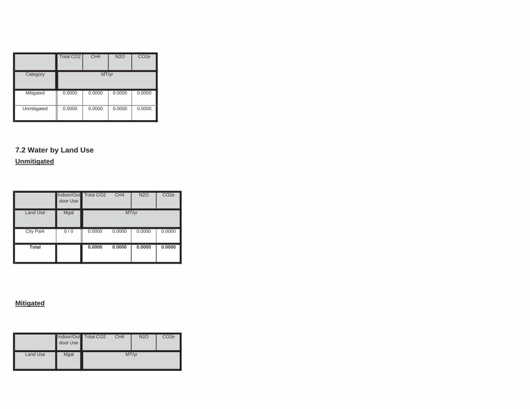
Land Use Mgal ton
MT/yr
Mitigated
Indoor/Outdoor Use
Total CO2 CH4 N2O CO2e
0.0000
Total 0.0000 0.0000 0.0000 0.0000
Land Use Mgal ton
MT/yr
City Park 0 / 0 0.0000 0.0000 0.0000
7.2 Water by Land Use
Unmitigated
Indoor/Outdoor Use
Total CO2 CH4 N2O CO2e
Unmitigated 0.0000 0.0000 0.0000 0.0000
Category ton
MT/yr
Mitigated 0.0000 0.0000 0.0000 0.0000
Total CO2 CH4 N2O CO2e
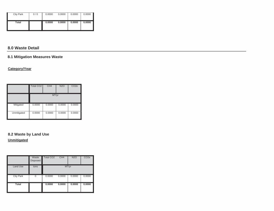
0.0000
Total 0.0000 0.0000 0.0000 0.0000
Land Use tons ton
MT/yr
City Park 0 0.0000 0.0000 0.0000
8.2 Waste by Land Use
Unmitigated
WasteDisposed
Total CO2 CH4 N2O CO2e
Unmitigated 0.0000 0.0000 0.0000 0.0000
ton
MT/yr
Mitigated 0.0000 0.0000 0.0000 0.0000
8.0 Waste Detail
8.1 Mitigation Measures Waste
Category/Year
Total CO2 CH4 N2O CO2e
0.0000
Total 0.0000 0.0000 0.0000 0.0000
City Park 0 / 0 0.0000 0.0000 0.0000

Load Factor Fuel Type
10.0 Vegetation
9.0 Operational Offroad
Equipment Type Number Hours/Day Days/Year Horse Power
0.0000
Total 0.0000 0.0000 0.0000 0.0000
Land Use tons ton
MT/yr
City Park 0 0.0000 0.0000 0.0000
Mitigated
WasteDisposed
Total CO2 CH4 N2O CO2e
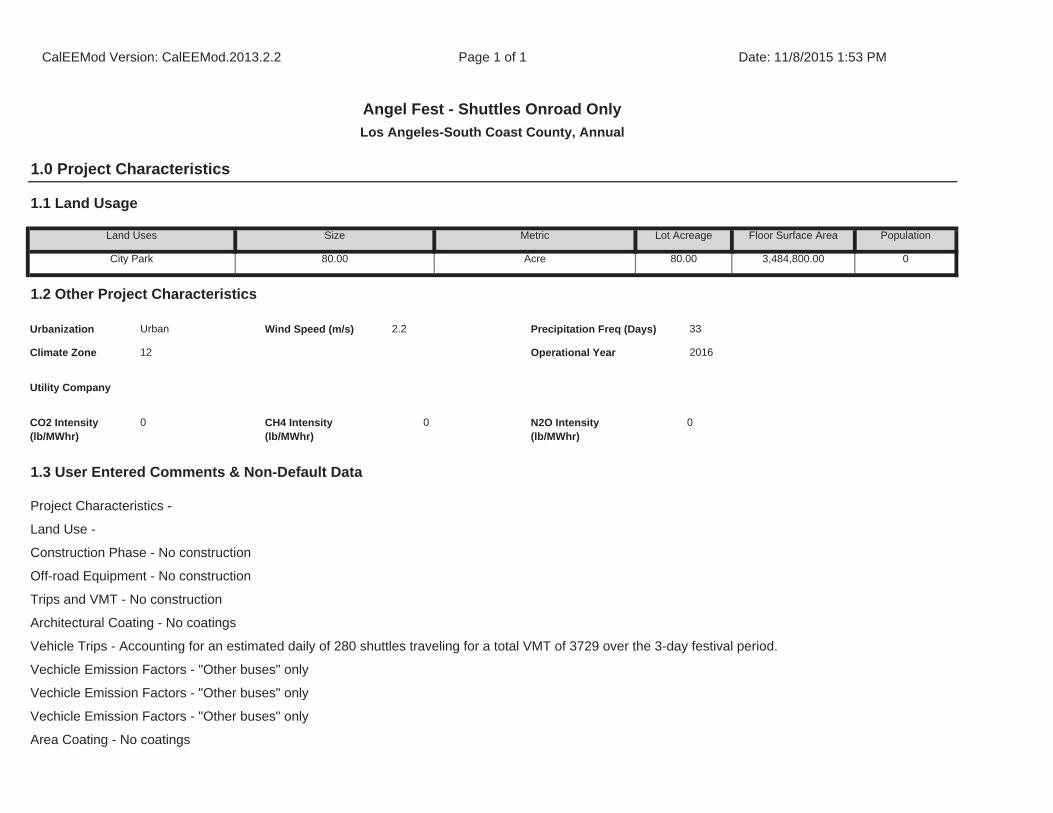
Architectural Coating - No coatings
Vehicle Trips - Accounting for an estimated daily of 280 shuttles traveling for a total VMT of 3729 over the 3-day festival period.
Vechicle Emission Factors - "Other buses" only
Vechicle Emission Factors - "Other buses" only
Vechicle Emission Factors - "Other buses" only
Area Coating - No coatings
1.3 User Entered Comments & Non-Default Data
Project Characteristics -
Land Use -
Construction Phase - No construction
Off-road Equipment - No construction
Trips and VMT - No construction
CO2 Intensity (lb/MWhr)
0 CH4 Intensity (lb/MWhr)
0 N2O Intensity (lb/MWhr)
0
33
Climate Zone 12 Operational Year 2016
Utility Company
1.2 Other Project Characteristics
Urbanization Urban Wind Speed (m/s) 2.2 Precipitation Freq (Days)
Population
City Park 80.00 Acre 80.00 3,484,800.00 0
1.1 Land Usage
Land Uses Size Metric Lot Acreage Floor Surface Area
CalEEMod Version: CalEEMod.2013.2.2 Page 1 of 1 Date: 11/8/2015 1:53 PM
Angel Fest - Shuttles Onroad Only
Los Angeles-South Coast County, Annual
1.0 Project Characteristics
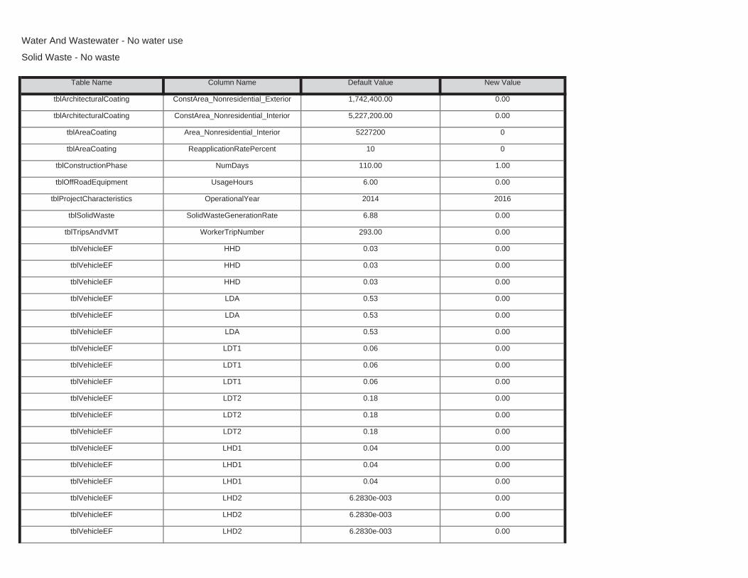
tblVehicleEF LHD2 6.2830e-003 0.00
tblVehicleEF LHD2 6.2830e-003 0.00
tblVehicleEF LHD2 6.2830e-003 0.00
tblVehicleEF LHD1 0.04 0.00
tblVehicleEF LHD1 0.04 0.00
tblVehicleEF LDT2 0.18 0.00
tblVehicleEF LHD1 0.04 0.00
tblVehicleEF LDT2 0.18 0.00
tblVehicleEF LDT2 0.18 0.00
tblVehicleEF LDT1 0.06 0.00
tblVehicleEF LDT1 0.06 0.00
tblVehicleEF LDA 0.53 0.00
tblVehicleEF LDT1 0.06 0.00
tblVehicleEF LDA 0.53 0.00
tblVehicleEF LDA 0.53 0.00
tblVehicleEF HHD 0.03 0.00
tblVehicleEF HHD 0.03 0.00
tblTripsAndVMT WorkerTripNumber 293.00 0.00
tblVehicleEF HHD 0.03 0.00
tblProjectCharacteristics OperationalYear 2014 2016
tblSolidWaste SolidWasteGenerationRate 6.88 0.00
tblConstructionPhase NumDays 110.00 1.00
tblOffRoadEquipment UsageHours 6.00 0.00
tblAreaCoating Area_Nonresidential_Interior 5227200 0
tblAreaCoating ReapplicationRatePercent 10 0
tblArchitecturalCoating ConstArea_Nonresidential_Exterior 1,742,400.00 0.00
tblArchitecturalCoating ConstArea_Nonresidential_Interior 5,227,200.00 0.00
Water And Wastewater - No water use
Solid Waste - No waste
Table Name Column Name Default Value New Value
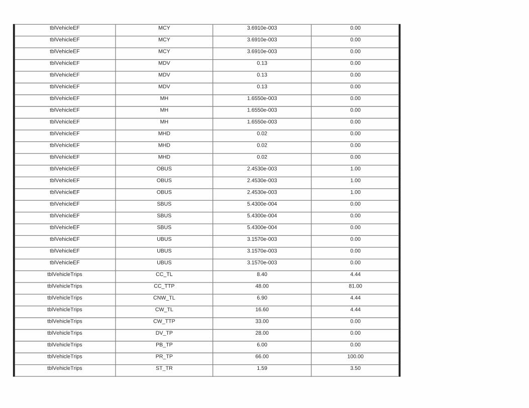
tblVehicleTrips ST_TR 1.59 3.50
tblVehicleTrips PB_TP 6.00 0.00
tblVehicleTrips PR_TP 66.00 100.00
tblVehicleTrips CW_TTP 33.00 0.00
tblVehicleTrips DV_TP 28.00 0.00
tblVehicleTrips CNW_TL 6.90 4.44
tblVehicleTrips CW_TL 16.60 4.44
tblVehicleTrips CC_TL 8.40 4.44
tblVehicleTrips CC_TTP 48.00 81.00
tblVehicleEF UBUS 3.1570e-003 0.00
tblVehicleEF UBUS 3.1570e-003 0.00
tblVehicleEF SBUS 5.4300e-004 0.00
tblVehicleEF UBUS 3.1570e-003 0.00
tblVehicleEF SBUS 5.4300e-004 0.00
tblVehicleEF SBUS 5.4300e-004 0.00
tblVehicleEF OBUS 2.4530e-003 1.00
tblVehicleEF OBUS 2.4530e-003 1.00
tblVehicleEF MHD 0.02 0.00
tblVehicleEF OBUS 2.4530e-003 1.00
tblVehicleEF MHD 0.02 0.00
tblVehicleEF MHD 0.02 0.00
tblVehicleEF MH 1.6550e-003 0.00
tblVehicleEF MH 1.6550e-003 0.00
tblVehicleEF MDV 0.13 0.00
tblVehicleEF MH 1.6550e-003 0.00
tblVehicleEF MDV 0.13 0.00
tblVehicleEF MDV 0.13 0.00
tblVehicleEF MCY 3.6910e-003 0.00
tblVehicleEF MCY 3.6910e-003 0.00
tblVehicleEF MCY 3.6910e-003 0.00
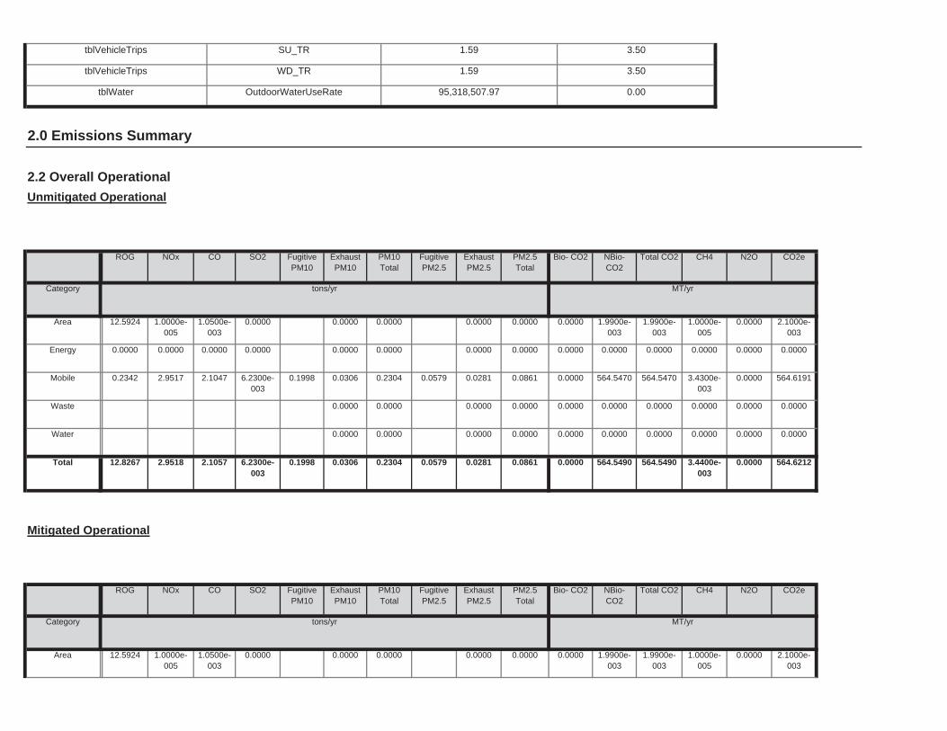
0.0000 1.9900e-003
1.9900e-003
1.0000e-005
0.0000 2.1000e-003
0.0000 0.0000 0.0000 0.0000Area 12.5924 1.0000e-005
1.0500e-003
0.0000
Total CO2 CH4 N2O CO2e
Category tons/yr MT/yr
PM10Total
FugitivePM2.5
ExhaustPM2.5
PM2.5Total
Bio- CO2 NBio- CO2
Mitigated Operational
ROG NOx CO SO2 Fugitive PM10
ExhaustPM10
0.0000 564.5490 564.5490 3.4400e-003
0.0000 564.62120.1998 0.0306 0.2304 0.0579 0.0281 0.0861Total 12.8267 2.9518 2.1057 6.2300e-003
0.0000 0.0000 0.0000 0.0000 0.0000 0.00000.0000 0.0000 0.0000 0.0000Water
0.0000 0.0000 0.0000 0.0000 0.0000 0.00000.0000 0.0000 0.0000 0.0000Waste
0.0000 564.5470 564.5470 3.4300e-003
0.0000 564.61910.1998 0.0306 0.2304 0.0579 0.0281 0.0861Mobile 0.2342 2.9517 2.1047 6.2300e-003
0.0000 0.0000 0.0000 0.0000 0.0000 0.00000.0000 0.0000 0.0000 0.0000Energy 0.0000 0.0000 0.0000 0.0000
0.0000 1.9900e-003
1.9900e-003
1.0000e-005
0.0000 2.1000e-003
0.0000 0.0000 0.0000 0.0000Area 12.5924 1.0000e-005
1.0500e-003
0.0000
Total CO2 CH4 N2O CO2e
Category tons/yr MT/yr
PM10Total
FugitivePM2.5
ExhaustPM2.5
PM2.5Total
Bio- CO2 NBio- CO2
2.2 Overall Operational
Unmitigated Operational
ROG NOx CO SO2 Fugitive PM10
ExhaustPM10
2.0 Emissions Summary
tblVehicleTrips WD_TR 1.59 3.50
tblWater OutdoorWaterUseRate 95,318,507.97 0.00
tblVehicleTrips SU_TR 1.59 3.50

Total 280.00 280.00 280.00 452,525 452,525
Annual VMT
City Park 280.00 280.00 280.00 452,525 452,525
4.2 Trip Summary Information
Average Daily Trip Rate Unmitigated Mitigated
Land Use Weekday Saturday Sunday Annual VMT
0.0000 564.5470 564.5470 3.4300e-003
0.0000 564.61910.1998 0.0306 0.2304 0.0579 0.0281 0.0861Unmitigated 0.2342 2.9517 2.1047 6.2300e-003
0.0000 564.5470 564.5470 3.4300e-003
0.0000 564.61910.1998 0.0306 0.2304 0.0579 0.0281 0.0861Mitigated 0.2342 2.9517 2.1047 6.2300e-003
NBio-CO2
Total CO2 CH4 N2O CO2e
Category tons/yr MT/yr
ExhaustPM10
PM10Total
FugitivePM2.5
ExhaustPM2.5
PM2.5Total
Bio- CO2
4.0 Operational Detail - Mobile
4.1 Mitigation Measures Mobile
ROG NOx CO SO2 Fugitive PM10
0.00 0.00 0.00 0.00 0.00 0.000.00 0.00 0.00 0.00 0.00 0.00
NBio-CO2 Total CO2 CH4 N20 CO2e
PercentReduction
0.00 0.00 0.00 0.00
ExhaustPM10
PM10Total
FugitivePM2.5
ExhaustPM2.5
PM2.5Total
Bio- CO2ROG NOx CO SO2 Fugitive PM10
0.0000 564.5490 564.5490 3.4400e-003
0.0000 564.62120.1998 0.0306 0.2304 0.0579 0.0281 0.0861Total 12.8267 2.9518 2.1057 6.2300e-003
0.0000 0.0000 0.0000 0.0000 0.0000 0.00000.0000 0.0000 0.0000 0.0000Water
0.0000 0.0000 0.0000 0.0000 0.0000 0.00000.0000 0.0000 0.0000 0.0000Waste
0.0000 564.5470 564.5470 3.4300e-003
0.0000 564.61910.1998 0.0306 0.2304 0.0579 0.0281 0.0861Mobile 0.2342 2.9517 2.1047 6.2300e-003
0.0000 0.0000 0.0000 0.0000 0.0000 0.00000.0000 0.0000 0.0000 0.0000Energy 0.0000 0.0000 0.0000 0.0000
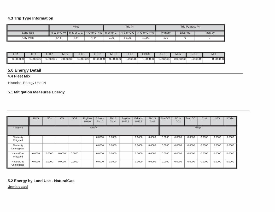
5.2 Energy by Land Use - NaturalGas
Unmitigated
0.0000 0.0000 0.0000 0.0000 0.0000 0.00000.0000 0.0000 0.0000 0.0000NaturalGasUnmitigated
0.0000 0.0000 0.0000 0.0000
0.0000 0.0000 0.0000 0.0000 0.0000 0.00000.0000 0.0000 0.0000 0.0000NaturalGasMitigated
0.0000 0.0000 0.0000 0.0000
0.0000 0.0000 0.0000 0.0000 0.0000 0.00000.0000 0.0000 0.0000 0.0000ElectricityUnmitigated
0.0000 0.0000 0.0000 0.0000 0.0000 0.00000.0000 0.0000 0.0000 0.0000ElectricityMitigated
NBio-CO2
Total CO2 CH4 N2O CO2e
Category tons/yr MT/yr
ExhaustPM10
PM10Total
FugitivePM2.5
ExhaustPM2.5
PM2.5Total
Bio- CO2
4.4 Fleet Mix
Historical Energy Use: N
5.1 Mitigation Measures Energy
ROG NOx CO SO2 Fugitive PM10
1.000000 0.000000 0.000000 0.000000 0.000000
5.0 Energy Detail
SBUS MH
0.000000 0.000000 0.000000 0.000000 0.000000 0.000000 0.000000 0.000000
LHD2 MHD HHD OBUS UBUS MCY
81.00 19.00 100 0 0
LDA LDT1 LDT2 MDV LHD1
H-S or C-C H-O or C-NW Primary Diverted Pass-by
City Park 4.44 4.44 4.44 0.00
4.3 Trip Type Information
Miles Trip % Trip Purpose %
Land Use H-W or C-W H-S or C-C H-O or C-NW H-W or C-W
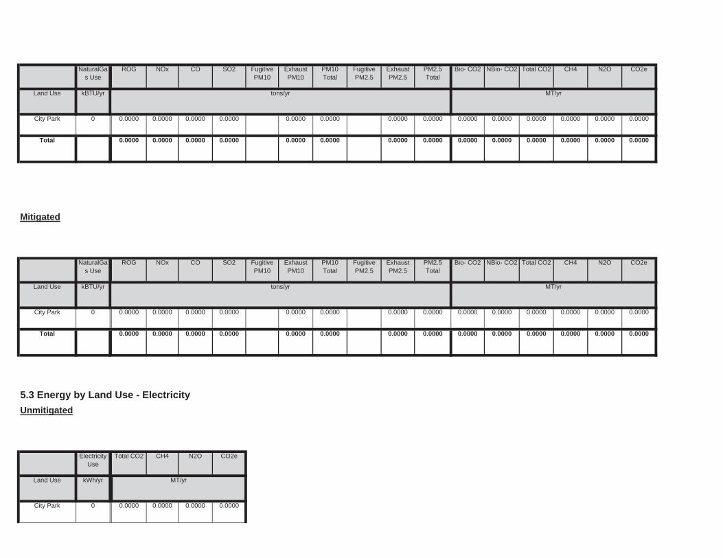
0.0000
Land Use kWh/yr ton
MT/yr
City Park 0 0.0000 0.0000 0.0000
Unmitigated
ElectricityUse
Total CO2 CH4 N2O CO2e
0.0000 0.0000 0.0000 0.0000 0.0000
5.3 Energy by Land Use - Electricity
0.0000 0.0000 0.0000 0.0000 0.0000
0.0000 0.0000
Total 0.0000 0.0000 0.0000 0.0000
0.0000 0.0000 0.0000 0.0000 0.0000 0.00000.0000 0.0000 0.0000 0.0000
CO2e
Land Use kBTU/yr tons/yr MT/yr
City Park 0 0.0000 0.0000
PM2.5Total
Bio- CO2 NBio- CO2 Total CO2 CH4 N2OSO2 Fugitive PM10
ExhaustPM10
PM10Total
FugitivePM2.5
ExhaustPM2.5
NaturalGas Use
ROG NOx CO
0.0000 0.0000 0.0000 0.0000
Mitigated
0.0000 0.0000 0.0000 0.0000 0.0000
0.0000
Total 0.0000 0.0000 0.0000 0.0000 0.0000
0.0000 0.0000 0.0000 0.0000 0.0000 0.00000.0000 0.0000 0.0000 0.0000City Park 0 0.0000 0.0000 0.0000
NBio- CO2 Total CO2 CH4 N2O CO2e
Land Use kBTU/yr tons/yr MT/yr
ExhaustPM10
PM10Total
FugitivePM2.5
ExhaustPM2.5
PM2.5Total
Bio- CO2NaturalGas Use
ROG NOx CO SO2 Fugitive PM10
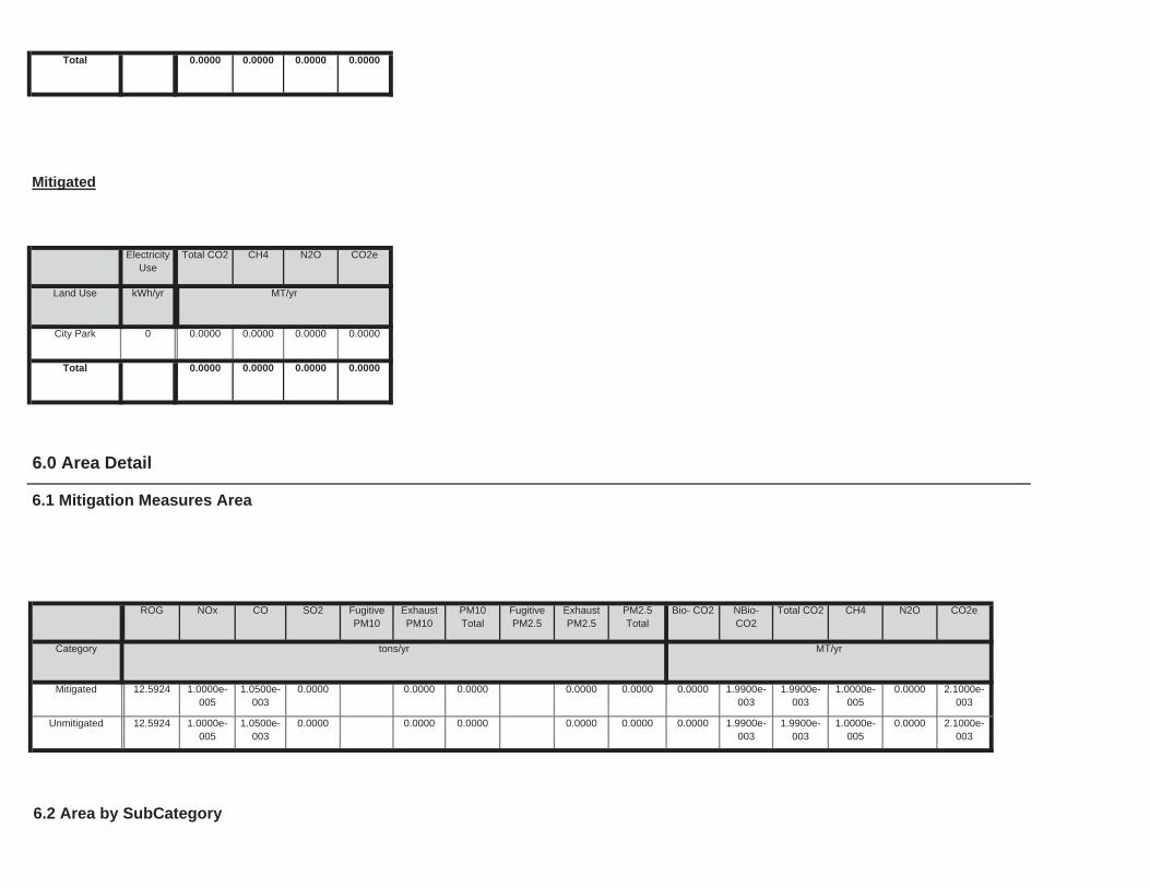
6.2 Area by SubCategory
0.0000 1.9900e-003
1.9900e-003
1.0000e-005
0.0000 2.1000e-003
0.0000 0.0000 0.0000 0.0000Unmitigated 12.5924 1.0000e-005
1.0500e-003
0.0000
0.0000 1.9900e-003
1.9900e-003
1.0000e-005
0.0000 2.1000e-003
0.0000 0.0000 0.0000 0.0000Mitigated 12.5924 1.0000e-005
1.0500e-003
0.0000
NBio-CO2
Total CO2 CH4 N2O CO2e
Category tons/yr MT/yr
ExhaustPM10
PM10Total
FugitivePM2.5
ExhaustPM2.5
PM2.5Total
Bio- CO2
6.0 Area Detail
6.1 Mitigation Measures Area
ROG NOx CO SO2 Fugitive PM10
0.0000
Total 0.0000 0.0000 0.0000 0.0000
Land Use kWh/yr ton
MT/yr
City Park 0 0.0000 0.0000 0.0000
Mitigated
ElectricityUse
Total CO2 CH4 N2O CO2e
Total 0.0000 0.0000 0.0000 0.0000
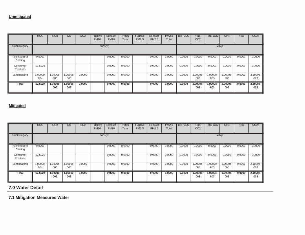
7.0 Water Detail
7.1 Mitigation Measures Water
0.0000 1.9900e-003
1.9900e-003
1.0000e-005
0.0000 2.1000e-003
0.0000 0.0000 0.0000 0.0000Total 12.5924 1.0000e-005
1.0500e-003
0.0000
0.0000 1.9900e-003
1.9900e-003
1.0000e-005
0.0000 2.1000e-003
0.0000 0.0000 0.0000 0.0000Landscaping 1.0000e-004
1.0000e-005
1.0500e-003
0.0000
0.0000 0.0000 0.0000 0.0000 0.0000 0.00000.0000 0.0000 0.0000 0.0000ConsumerProducts
12.5923
0.0000 0.0000 0.0000 0.0000 0.0000 0.00000.0000 0.0000 0.0000 0.0000ArchitecturalCoating
0.0000
Total CO2 CH4 N2O CO2e
SubCategory tons/yr MT/yr
PM10Total
FugitivePM2.5
ExhaustPM2.5
PM2.5Total
Bio- CO2 NBio- CO2
Mitigated
ROG NOx CO SO2 Fugitive PM10
ExhaustPM10
0.0000 1.9900e-003
1.9900e-003
1.0000e-005
0.0000 2.1000e-003
0.0000 0.0000 0.0000 0.0000Total 12.5924 1.0000e-005
1.0500e-003
0.0000
0.0000 1.9900e-003
1.9900e-003
1.0000e-005
0.0000 2.1000e-003
0.0000 0.0000 0.0000 0.0000Landscaping 1.0000e-004
1.0000e-005
1.0500e-003
0.0000
0.0000 0.0000 0.0000 0.0000 0.0000 0.00000.0000 0.0000 0.0000 0.0000ConsumerProducts
12.5923
0.0000 0.0000 0.0000 0.0000 0.0000 0.00000.0000 0.0000 0.0000 0.0000ArchitecturalCoating
0.0000
Total CO2 CH4 N2O CO2e
SubCategory tons/yr MT/yr
PM10Total
FugitivePM2.5
ExhaustPM2.5
PM2.5Total
Bio- CO2 NBio- CO2
Unmitigated
ROG NOx CO SO2 Fugitive PM10
ExhaustPM10

Land Use Mgal ton
MT/yr
Mitigated
Indoor/Outdoor Use
Total CO2 CH4 N2O CO2e
0.0000
Total 0.0000 0.0000 0.0000 0.0000
Land Use Mgal ton
MT/yr
City Park 0 / 0 0.0000 0.0000 0.0000
7.2 Water by Land Use
Unmitigated
Indoor/Outdoor Use
Total CO2 CH4 N2O CO2e
Unmitigated 0.0000 0.0000 0.0000 0.0000
Category ton
MT/yr
Mitigated 0.0000 0.0000 0.0000 0.0000
Total CO2 CH4 N2O CO2e

0.0000
Total 0.0000 0.0000 0.0000 0.0000
Land Use tons ton
MT/yr
City Park 0 0.0000 0.0000 0.0000
8.2 Waste by Land Use
Unmitigated
WasteDisposed
Total CO2 CH4 N2O CO2e
Unmitigated 0.0000 0.0000 0.0000 0.0000
ton
MT/yr
Mitigated 0.0000 0.0000 0.0000 0.0000
8.0 Waste Detail
8.1 Mitigation Measures Waste
Category/Year
Total CO2 CH4 N2O CO2e
0.0000
Total 0.0000 0.0000 0.0000 0.0000
City Park 0 / 0 0.0000 0.0000 0.0000
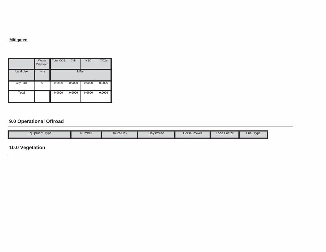
Load Factor Fuel Type
10.0 Vegetation
9.0 Operational Offroad
Equipment Type Number Hours/Day Days/Year Horse Power
0.0000
Total 0.0000 0.0000 0.0000 0.0000
Land Use tons ton
MT/yr
City Park 0 0.0000 0.0000 0.0000
Mitigated
WasteDisposed
Total CO2 CH4 N2O CO2e
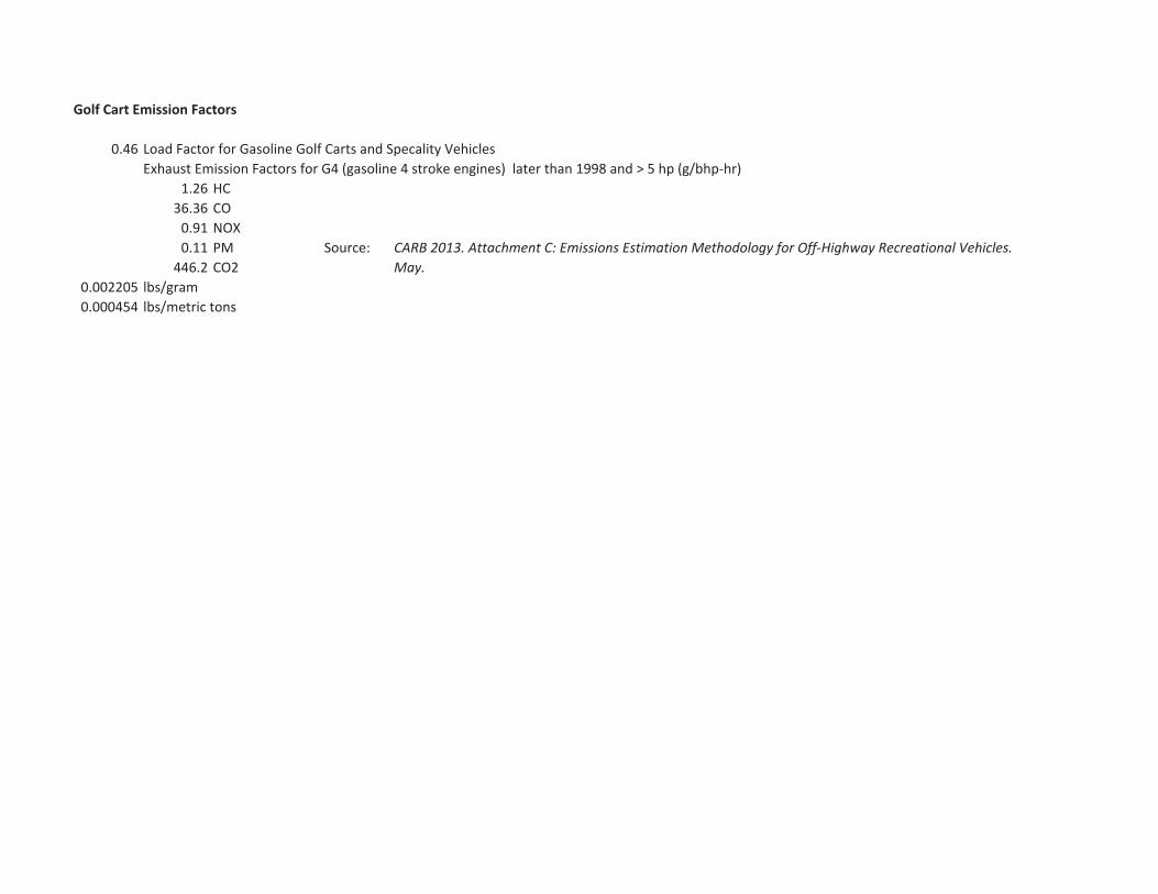
Golf Cart Emission Factors
0.46 Load Factor for Gasoline Golf Carts and Specality VehiclesExhaust Emission Factors for G4 (gasoline 4 stroke engines) later than 1998 and > 5 hp (g/bhp hr)
1.26 HC36.36 CO0.91 NOX0.11 PM Source:446.2 CO2
0.002205 lbs/gram0.000454 lbs/metric tons
CARB 2013. Attachment C: Emissions Estimation Methodology for Off Highway Recreational Vehicles.May.
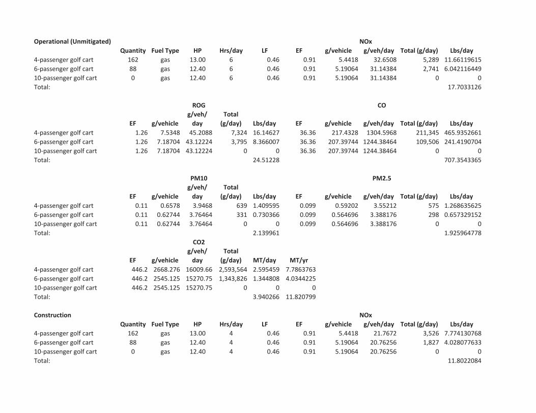
Operational (Unmitigated)Quantity Fuel Type HP Hrs/day LF EF g/vehicle g/veh/day Total (g/day) Lbs/day
4 passenger golf cart 162 gas 13.00 6 0.46 0.91 5.4418 32.6508 5,289 11.661196156 passenger golf cart 88 gas 12.40 6 0.46 0.91 5.19064 31.14384 2,741 6.04211644910 passenger golf cart 0 gas 12.40 6 0.46 0.91 5.19064 31.14384 0 0Total: 17.7033126
EF g/vehicleg/veh/day
Total(g/day) Lbs/day EF g/vehicle g/veh/day Total (g/day) Lbs/day
4 passenger golf cart 1.26 7.5348 45.2088 7,324 16.14627 36.36 217.4328 1304.5968 211,345 465.93526616 passenger golf cart 1.26 7.18704 43.12224 3,795 8.366007 36.36 207.39744 1244.38464 109,506 241.419070410 passenger golf cart 1.26 7.18704 43.12224 0 0 36.36 207.39744 1244.38464 0 0Total: 24.51228 707.3543365
EF g/vehicleg/veh/day
Total(g/day) Lbs/day EF g/vehicle g/veh/day Total (g/day) Lbs/day
4 passenger golf cart 0.11 0.6578 3.9468 639 1.409595 0.099 0.59202 3.55212 575 1.2686356256 passenger golf cart 0.11 0.62744 3.76464 331 0.730366 0.099 0.564696 3.388176 298 0.65732915210 passenger golf cart 0.11 0.62744 3.76464 0 0 0.099 0.564696 3.388176 0 0Total: 2.139961 1.925964778
EF g/vehicleg/veh/day
Total(g/day) MT/day MT/yr
4 passenger golf cart 446.2 2668.276 16009.66 2,593,564 2.595459 7.78637636 passenger golf cart 446.2 2545.125 15270.75 1,343,826 1.344808 4.034422510 passenger golf cart 446.2 2545.125 15270.75 0 0 0Total: 3.940266 11.820799
ConstructionQuantity Fuel Type HP Hrs/day LF EF g/vehicle g/veh/day Total (g/day) Lbs/day
4 passenger golf cart 162 gas 13.00 4 0.46 0.91 5.4418 21.7672 3,526 7.7741307686 passenger golf cart 88 gas 12.40 4 0.46 0.91 5.19064 20.76256 1,827 4.02807763310 passenger golf cart 0 gas 12.40 4 0.46 0.91 5.19064 20.76256 0 0Total: 11.8022084
NOx
ROG CO
PM10 PM2.5
CO2
NOx
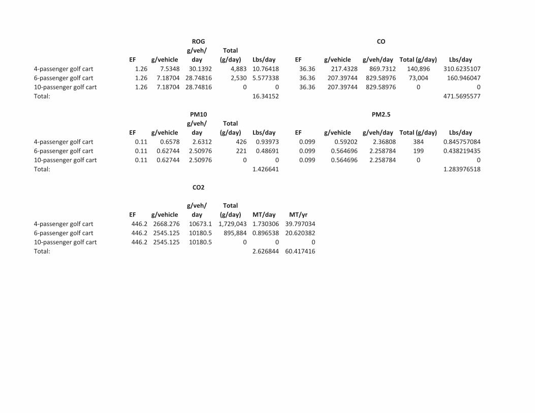
EF g/vehicleg/veh/day
Total(g/day) Lbs/day EF g/vehicle g/veh/day Total (g/day) Lbs/day
4 passenger golf cart 1.26 7.5348 30.1392 4,883 10.76418 36.36 217.4328 869.7312 140,896 310.62351076 passenger golf cart 1.26 7.18704 28.74816 2,530 5.577338 36.36 207.39744 829.58976 73,004 160.94604710 passenger golf cart 1.26 7.18704 28.74816 0 0 36.36 207.39744 829.58976 0 0Total: 16.34152 471.5695577
EF g/vehicleg/veh/day
Total(g/day) Lbs/day EF g/vehicle g/veh/day Total (g/day) Lbs/day
4 passenger golf cart 0.11 0.6578 2.6312 426 0.93973 0.099 0.59202 2.36808 384 0.8457570846 passenger golf cart 0.11 0.62744 2.50976 221 0.48691 0.099 0.564696 2.258784 199 0.43821943510 passenger golf cart 0.11 0.62744 2.50976 0 0 0.099 0.564696 2.258784 0 0Total: 1.426641 1.283976518
EF g/vehicleg/veh/day
Total(g/day) MT/day MT/yr
4 passenger golf cart 446.2 2668.276 10673.1 1,729,043 1.730306 39.7970346 passenger golf cart 446.2 2545.125 10180.5 895,884 0.896538 20.62038210 passenger golf cart 446.2 2545.125 10180.5 0 0 0Total: 2.626844 60.417416
ROG CO
PM10 PM2.5
CO2


AngelFest 150107
Draft Environmental Assessment April 2016
APPENDIX B Noise

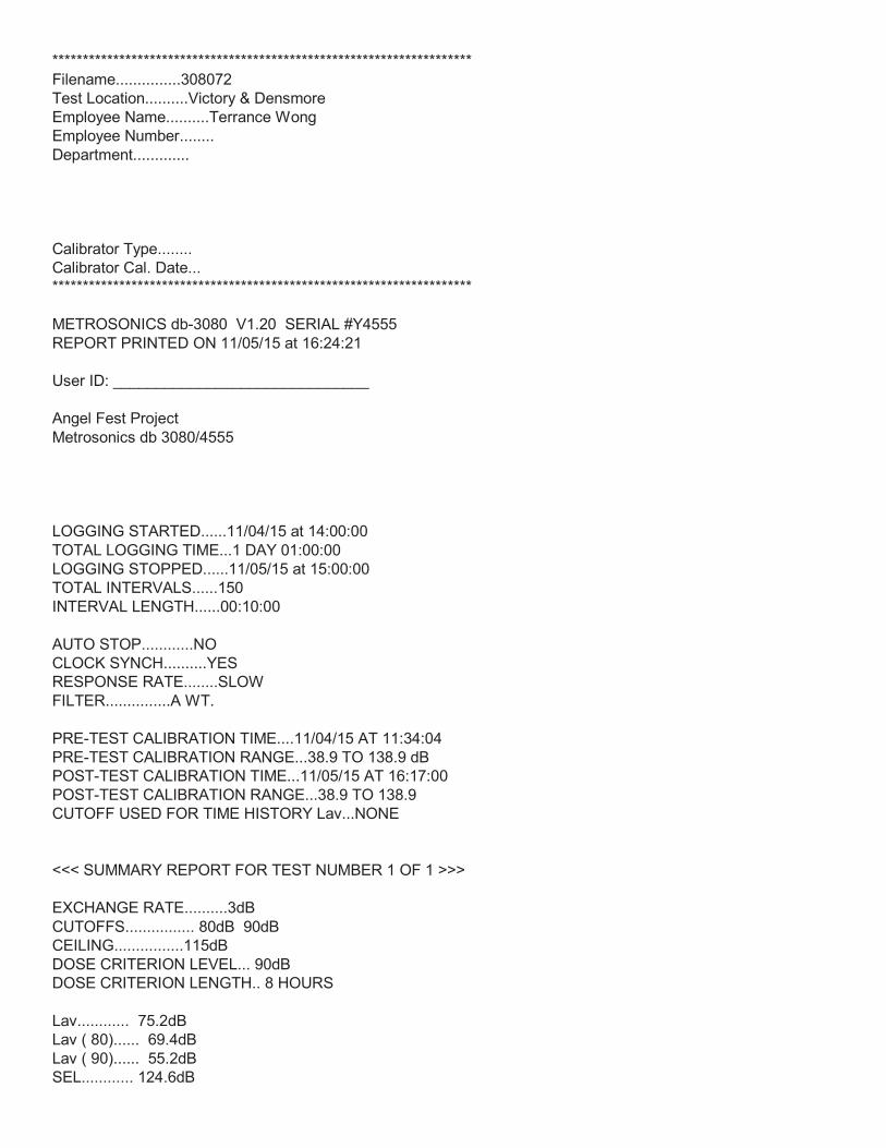
*********************************************************************Filename...............308072Test Location..........Victory & Densmore Employee Name..........Terrance Wong Employee Number........ Department.............
Calibrator Type........ Calibrator Cal. Date... *********************************************************************
METROSONICS db-3080 V1.20 SERIAL #Y4555REPORT PRINTED ON 11/05/15 at 16:24:21
User ID: ______________________________
Angel Fest Project Metrosonics db 3080/4555
LOGGING STARTED......11/04/15 at 14:00:00TOTAL LOGGING TIME...1 DAY 01:00:00LOGGING STOPPED......11/05/15 at 15:00:00TOTAL INTERVALS......150INTERVAL LENGTH......00:10:00
AUTO STOP............NOCLOCK SYNCH..........YESRESPONSE RATE........SLOWFILTER...............A WT.
PRE-TEST CALIBRATION TIME....11/04/15 AT 11:34:04PRE-TEST CALIBRATION RANGE...38.9 TO 138.9 dBPOST-TEST CALIBRATION TIME...11/05/15 AT 16:17:00POST-TEST CALIBRATION RANGE...38.9 TO 138.9CUTOFF USED FOR TIME HISTORY Lav...NONE
<<< SUMMARY REPORT FOR TEST NUMBER 1 OF 1 >>>
EXCHANGE RATE..........3dBCUTOFFS................ 80dB 90dBCEILING................115dBDOSE CRITERION LEVEL... 90dBDOSE CRITERION LENGTH.. 8 HOURS
Lav............ 75.2dBLav ( 80)...... 69.4dBLav ( 90)...... 55.2dBSEL............ 124.6dB

TWA............ 80.1dBTWA ( 80)...... 74.4dBTWA ( 90)...... 60.1dB
Lmax........... 98.0dB 11/04/15 at 22:28:51Lpk............ 121.2dB 11/05/15 at 14:58:51TIME OVER 115dB...00:00:00.00
DOSE ( 80)........ 2.70%DOSE ( 90)........ 0.10%
<<< TIME HISTORY REPORT FOR TEST NUMBER 1 OF 1 >>>
TIME Lav Lmax L(10.0) L(90.0) dBA dBA dBA dBA11/04/1514:00:00 75.9 84.1 79.9 63.914:10:00 76.3 83.8 79.9 62.914:20:00 76.8 83.6 80.9 67.914:30:00 76.1 87.0 79.9 61.914:40:00 76.4 84.4 80.9 64.914:50:00 77.0 82.8 80.9 70.915:00:00 77.0 83.4 80.9 66.915:10:00 76.4 82.4 79.9 65.915:20:00 76.6 84.8 79.9 66.915:30:00 76.8 83.8 79.9 62.915:40:00 76.9 85.2 79.9 66.915:50:00 76.6 87.6 79.9 66.916:00:00 76.5 82.8 79.9 62.916:10:00 76.8 87.2 79.9 66.916:20:00 77.3 83.2 79.9 67.916:30:00 77.0 83.4 79.9 70.916:40:00 77.0 82.1 79.9 71.916:50:00 76.8 85.2 79.9 65.917:00:00 76.3 84.2 79.9 65.917:10:00 76.6 82.4 79.9 67.917:20:00 76.8 84.2 79.9 67.917:30:00 76.8 82.4 79.9 68.917:40:00 78.0 91.6 79.9 69.917:50:00 76.6 81.2 79.9 70.918:00:00 76.3 82.0 79.9 66.918:10:00 75.9 81.2 78.9 64.918:20:00 76.4 82.0 79.9 69.918:30:00 76.5 83.5 79.9 69.918:40:00 76.4 84.0 79.9 68.918:50:00 76.1 83.6 78.9 69.919:00:00 75.8 84.0 79.9 66.919:10:00 76.3 88.1 79.9 66.919:20:00 75.8 84.8 79.9 65.919:30:00 75.2 82.6 78.9 65.919:40:00 75.1 82.0 78.9 66.919:50:00 74.0 80.4 77.9 63.920:00:00 75.3 83.6 78.9 66.9

20:10:00 74.7 82.8 78.9 63.920:20:00 74.4 82.3 78.9 62.920:30:00 74.6 82.4 78.9 64.920:40:00 73.8 82.0 77.9 64.920:50:00 74.0 82.7 77.9 64.921:00:00 73.9 82.0 77.9 63.921:10:00 74.6 82.0 78.9 63.921:20:00 74.3 86.0 78.9 62.921:30:00 73.3 82.4 77.9 58.921:40:00 73.6 84.8 77.9 60.921:50:00 73.4 83.6 77.9 59.922:00:00 72.8 81.6 77.9 59.922:10:00 73.4 81.2 77.9 60.922:20:00 77.6 98.0 78.9 60.922:30:00 72.4 82.6 76.9 61.922:40:00 71.9 81.0 76.9 56.922:50:00 71.4 82.3 75.9 55.923:00:00 71.5 82.6 75.9 57.923:10:00 70.8 80.6 75.9 58.923:20:00 70.9 88.4 74.9 56.923:30:00 70.5 81.3 74.9 56.923:40:00 70.2 81.6 74.9 56.923:50:00 69.2 80.4 74.9 54.900:00:00 68.6 81.2 73.9 55.900:10:00 68.3 79.8 73.9 54.900:20:00 68.4 80.6 73.9 53.900:30:00 66.0 80.0 70.9 51.900:40:00 66.8 80.2 71.9 54.900:50:00 67.3 77.8 72.9 55.901:00:00 66.6 81.6 71.9 52.901:10:00 66.3 80.2 70.9 53.901:20:00 66.4 83.0 71.9 52.901:30:00 66.5 80.2 70.9 51.901:40:00 64.1 79.2 68.9 50.901:50:00 65.0 80.0 69.9 51.902:00:00 64.2 80.2 68.9 50.902:10:00 65.2 78.3 69.9 54.902:20:00 66.0 78.8 70.9 50.902:30:00 63.6 79.6 67.9 53.902:40:00 66.8 82.6 71.9 53.902:50:00 64.0 76.7 68.9 52.903:00:00 65.9 85.6 68.9 52.903:10:00 64.8 78.8 69.9 51.903:20:00 62.9 81.0 66.9 51.903:30:00 65.6 83.6 69.9 52.903:40:00 67.0 80.6 71.9 55.903:50:00 65.6 78.0 70.9 54.904:00:00 67.5 80.9 72.9 55.904:10:00 68.2 82.7 72.9 57.904:20:00 68.2 81.1 72.9 57.904:30:00 69.0 83.2 72.9 58.904:40:00 70.6 81.6 75.9 59.904:50:00 71.2 84.4 75.9 58.905:00:00 70.6 82.0 74.9 58.905:10:00 72.3 84.8 76.9 58.9
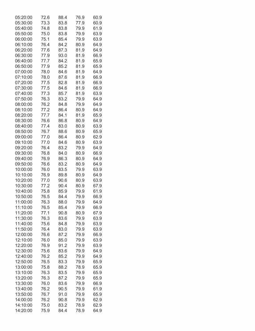
05:20:00 72.6 88.4 76.9 60.905:30:00 73.3 83.8 77.9 60.905:40:00 74.8 83.8 79.9 61.905:50:00 75.0 83.8 79.9 63.906:00:00 75.1 85.4 79.9 63.906:10:00 76.4 84.2 80.9 64.906:20:00 77.6 87.3 81.9 64.906:30:00 77.9 93.0 81.9 66.906:40:00 77.7 84.2 81.9 65.906:50:00 77.9 85.2 81.9 65.907:00:00 78.0 84.6 81.9 64.907:10:00 78.0 87.6 81.9 66.907:20:00 77.5 82.8 81.9 66.907:30:00 77.5 84.6 81.9 66.907:40:00 77.3 85.7 81.9 63.907:50:00 76.3 83.2 79.9 64.908:00:00 76.2 84.8 79.9 64.908:10:00 77.2 86.4 80.9 64.908:20:00 77.7 84.1 81.9 65.908:30:00 76.6 86.8 80.9 64.908:40:00 77.4 83.0 80.9 63.908:50:00 76.7 88.6 80.9 65.909:00:00 77.0 86.4 80.9 62.909:10:00 77.0 84.6 80.9 63.909:20:00 76.4 83.2 79.9 64.909:30:00 76.8 84.0 80.9 66.909:40:00 76.9 86.3 80.9 64.909:50:00 76.6 83.2 80.9 64.910:00:00 76.0 83.5 79.9 63.910:10:00 76.9 89.8 80.9 64.910:20:00 77.0 90.6 80.9 63.910:30:00 77.2 90.4 80.9 67.910:40:00 75.8 85.9 79.9 61.910:50:00 76.5 84.4 79.9 66.911:00:00 76.3 88.0 79.9 64.911:10:00 76.5 85.4 79.9 66.911:20:00 77.1 90.8 80.9 67.911:30:00 76.3 83.6 79.9 63.911:40:00 75.6 84.8 79.9 63.911:50:00 76.4 83.0 79.9 63.912:00:00 76.6 87.2 79.9 66.912:10:00 76.0 85.0 79.9 63.912:20:00 76.9 91.2 79.9 63.912:30:00 75.6 83.6 79.9 64.912:40:00 76.2 85.2 79.9 64.912:50:00 76.5 83.3 79.9 65.913:00:00 75.8 88.2 78.9 65.913:10:00 76.3 83.5 79.9 65.913:20:00 76.3 87.2 79.9 65.913:30:00 76.0 83.6 79.9 66.913:40:00 76.2 90.5 79.9 61.913:50:00 76.7 91.0 79.9 65.914:00:00 76.2 90.8 79.9 62.914:10:00 75.0 83.2 78.9 62.914:20:00 75.9 84.4 78.9 64.9

14:30:00 77.0 86.4 79.9 64.914:40:00 76.6 86.5 79.9 64.914:50:00 76.7 89.4 79.9 64.9
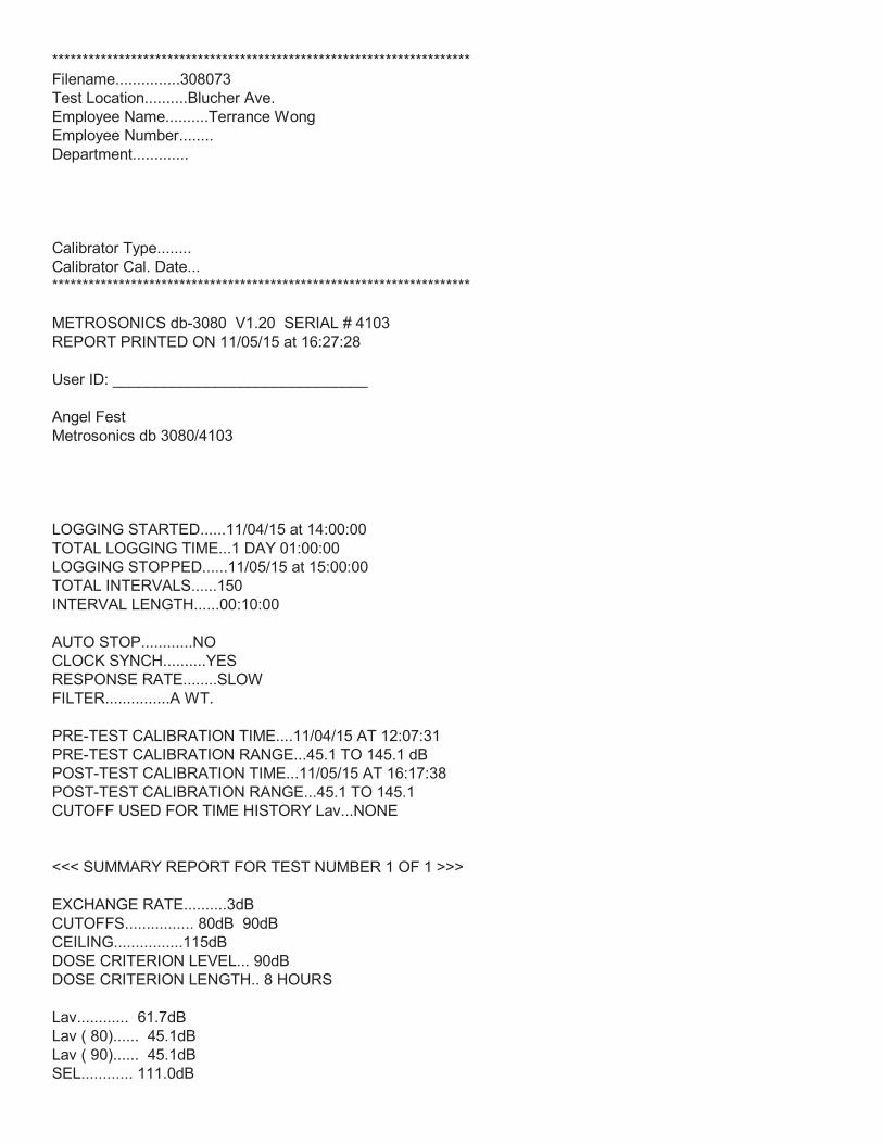
*********************************************************************Filename...............308073Test Location..........Blucher Ave. Employee Name..........Terrance Wong Employee Number........ Department.............
Calibrator Type........ Calibrator Cal. Date... *********************************************************************
METROSONICS db-3080 V1.20 SERIAL # 4103REPORT PRINTED ON 11/05/15 at 16:27:28
User ID: ______________________________
Angel Fest Metrosonics db 3080/4103
LOGGING STARTED......11/04/15 at 14:00:00TOTAL LOGGING TIME...1 DAY 01:00:00LOGGING STOPPED......11/05/15 at 15:00:00TOTAL INTERVALS......150INTERVAL LENGTH......00:10:00
AUTO STOP............NOCLOCK SYNCH..........YESRESPONSE RATE........SLOWFILTER...............A WT.
PRE-TEST CALIBRATION TIME....11/04/15 AT 12:07:31PRE-TEST CALIBRATION RANGE...45.1 TO 145.1 dBPOST-TEST CALIBRATION TIME...11/05/15 AT 16:17:38POST-TEST CALIBRATION RANGE...45.1 TO 145.1CUTOFF USED FOR TIME HISTORY Lav...NONE
<<< SUMMARY REPORT FOR TEST NUMBER 1 OF 1 >>>
EXCHANGE RATE..........3dBCUTOFFS................ 80dB 90dBCEILING................115dBDOSE CRITERION LEVEL... 90dBDOSE CRITERION LENGTH.. 8 HOURS
Lav............ 61.7dBLav ( 80)...... 45.1dBLav ( 90)...... 45.1dBSEL............ 111.0dB
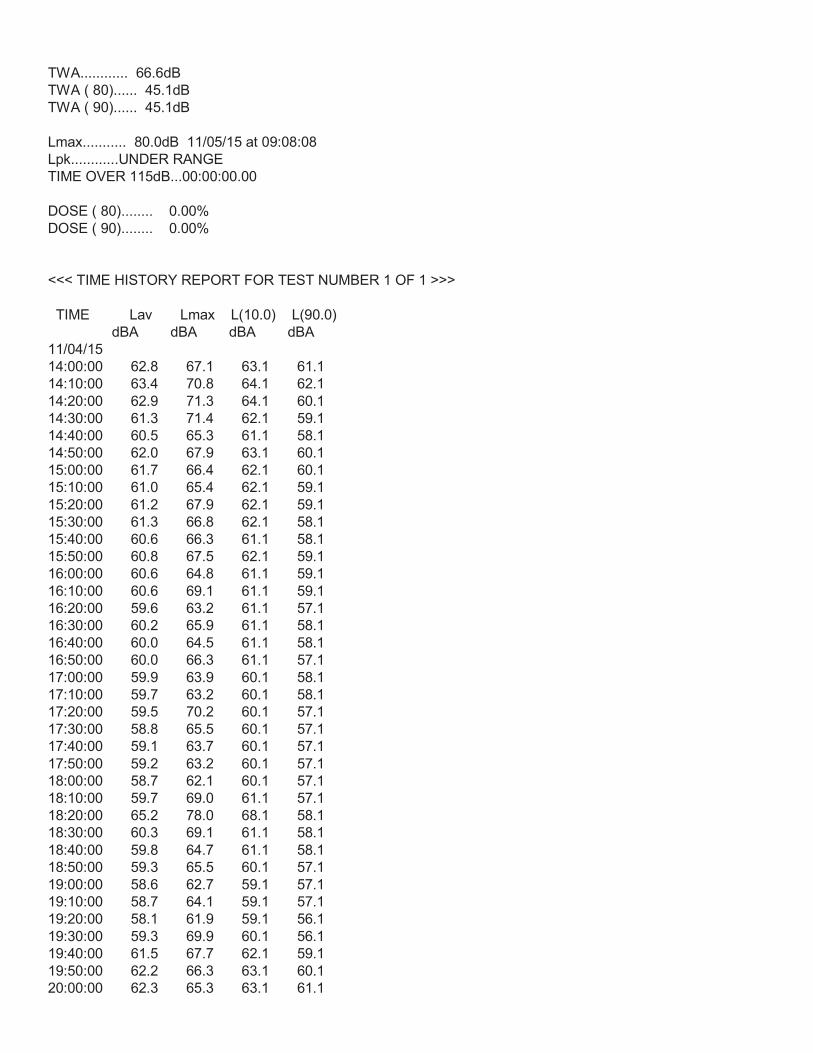
TWA............ 66.6dBTWA ( 80)...... 45.1dBTWA ( 90)...... 45.1dB
Lmax........... 80.0dB 11/05/15 at 09:08:08Lpk............UNDER RANGETIME OVER 115dB...00:00:00.00
DOSE ( 80)........ 0.00%DOSE ( 90)........ 0.00%
<<< TIME HISTORY REPORT FOR TEST NUMBER 1 OF 1 >>>
TIME Lav Lmax L(10.0) L(90.0) dBA dBA dBA dBA11/04/1514:00:00 62.8 67.1 63.1 61.114:10:00 63.4 70.8 64.1 62.114:20:00 62.9 71.3 64.1 60.114:30:00 61.3 71.4 62.1 59.114:40:00 60.5 65.3 61.1 58.114:50:00 62.0 67.9 63.1 60.115:00:00 61.7 66.4 62.1 60.115:10:00 61.0 65.4 62.1 59.115:20:00 61.2 67.9 62.1 59.115:30:00 61.3 66.8 62.1 58.115:40:00 60.6 66.3 61.1 58.115:50:00 60.8 67.5 62.1 59.116:00:00 60.6 64.8 61.1 59.116:10:00 60.6 69.1 61.1 59.116:20:00 59.6 63.2 61.1 57.116:30:00 60.2 65.9 61.1 58.116:40:00 60.0 64.5 61.1 58.116:50:00 60.0 66.3 61.1 57.117:00:00 59.9 63.9 60.1 58.117:10:00 59.7 63.2 60.1 58.117:20:00 59.5 70.2 60.1 57.117:30:00 58.8 65.5 60.1 57.117:40:00 59.1 63.7 60.1 57.117:50:00 59.2 63.2 60.1 57.118:00:00 58.7 62.1 60.1 57.118:10:00 59.7 69.0 61.1 57.118:20:00 65.2 78.0 68.1 58.118:30:00 60.3 69.1 61.1 58.118:40:00 59.8 64.7 61.1 58.118:50:00 59.3 65.5 60.1 57.119:00:00 58.6 62.7 59.1 57.119:10:00 58.7 64.1 59.1 57.119:20:00 58.1 61.9 59.1 56.119:30:00 59.3 69.9 60.1 56.119:40:00 61.5 67.7 62.1 59.119:50:00 62.2 66.3 63.1 60.120:00:00 62.3 65.3 63.1 61.1
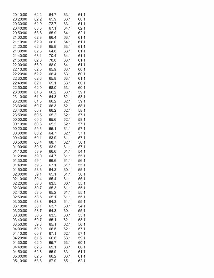
20:10:00 62.2 64.7 63.1 61.120:20:00 62.2 65.9 63.1 60.120:30:00 62.9 72.7 63.1 61.120:40:00 63.6 67.1 64.1 62.120:50:00 63.8 65.9 64.1 62.121:00:00 62.8 66.4 63.1 61.121:10:00 62.9 66.0 64.1 61.121:20:00 62.6 65.9 63.1 61.121:30:00 62.6 64.8 63.1 61.121:40:00 63.1 70.4 64.1 61.121:50:00 62.8 70.0 63.1 61.122:00:00 63.0 68.0 64.1 61.122:10:00 62.5 65.9 63.1 60.122:20:00 62.2 66.4 63.1 60.122:30:00 62.6 65.8 63.1 61.122:40:00 62.1 65.1 63.1 60.122:50:00 62.0 68.0 63.1 60.123:00:00 61.5 66.2 63.1 59.123:10:00 61.0 64.3 62.1 58.123:20:00 61.3 66.2 62.1 59.123:30:00 60.7 66.3 62.1 58.123:40:00 60.7 66.2 62.1 58.123:50:00 60.5 65.2 62.1 57.100:00:00 60.6 65.6 62.1 58.100:10:00 60.3 65.2 62.1 57.100:20:00 59.6 65.1 61.1 57.100:30:00 60.2 64.7 62.1 57.100:40:00 60.1 63.9 61.1 57.100:50:00 60.4 68.7 62.1 56.101:00:00 59.5 63.9 61.1 57.101:10:00 58.9 66.6 61.1 54.101:20:00 59.0 64.7 61.1 55.101:30:00 59.4 66.6 61.1 56.101:40:00 59.3 67.1 61.1 55.101:50:00 58.6 64.3 60.1 55.102:00:00 59.1 65.1 61.1 56.102:10:00 59.4 65.4 61.1 56.102:20:00 58.6 63.5 60.1 55.102:30:00 59.7 65.3 61.1 55.102:40:00 58.5 65.2 61.1 55.102:50:00 58.6 65.1 61.1 55.103:00:00 58.8 64.3 61.1 55.103:10:00 58.1 63.7 60.1 54.103:20:00 58.7 64.3 60.1 55.103:30:00 58.5 63.5 60.1 55.103:40:00 60.7 65.1 62.1 58.103:50:00 59.8 65.1 62.1 56.104:00:00 60.0 66.5 62.1 57.104:10:00 60.7 67.1 62.1 57.104:20:00 61.5 66.6 63.1 59.104:30:00 62.5 65.7 63.1 60.104:40:00 62.3 69.1 63.1 60.104:50:00 62.6 65.9 63.1 61.105:00:00 62.5 66.2 63.1 61.105:10:00 63.8 67.9 65.1 62.1
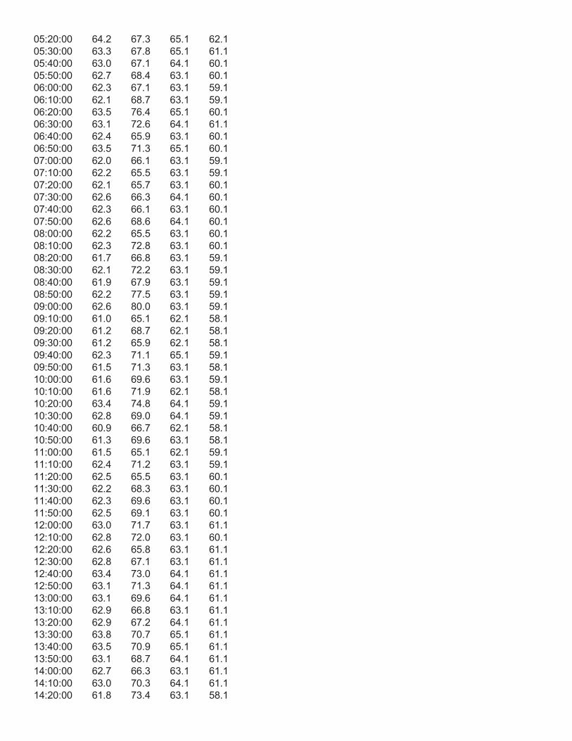
05:20:00 64.2 67.3 65.1 62.105:30:00 63.3 67.8 65.1 61.105:40:00 63.0 67.1 64.1 60.105:50:00 62.7 68.4 63.1 60.106:00:00 62.3 67.1 63.1 59.106:10:00 62.1 68.7 63.1 59.106:20:00 63.5 76.4 65.1 60.106:30:00 63.1 72.6 64.1 61.106:40:00 62.4 65.9 63.1 60.106:50:00 63.5 71.3 65.1 60.107:00:00 62.0 66.1 63.1 59.107:10:00 62.2 65.5 63.1 59.107:20:00 62.1 65.7 63.1 60.107:30:00 62.6 66.3 64.1 60.107:40:00 62.3 66.1 63.1 60.107:50:00 62.6 68.6 64.1 60.108:00:00 62.2 65.5 63.1 60.108:10:00 62.3 72.8 63.1 60.108:20:00 61.7 66.8 63.1 59.108:30:00 62.1 72.2 63.1 59.108:40:00 61.9 67.9 63.1 59.108:50:00 62.2 77.5 63.1 59.109:00:00 62.6 80.0 63.1 59.109:10:00 61.0 65.1 62.1 58.109:20:00 61.2 68.7 62.1 58.109:30:00 61.2 65.9 62.1 58.109:40:00 62.3 71.1 65.1 59.109:50:00 61.5 71.3 63.1 58.110:00:00 61.6 69.6 63.1 59.110:10:00 61.6 71.9 62.1 58.110:20:00 63.4 74.8 64.1 59.110:30:00 62.8 69.0 64.1 59.110:40:00 60.9 66.7 62.1 58.110:50:00 61.3 69.6 63.1 58.111:00:00 61.5 65.1 62.1 59.111:10:00 62.4 71.2 63.1 59.111:20:00 62.5 65.5 63.1 60.111:30:00 62.2 68.3 63.1 60.111:40:00 62.3 69.6 63.1 60.111:50:00 62.5 69.1 63.1 60.112:00:00 63.0 71.7 63.1 61.112:10:00 62.8 72.0 63.1 60.112:20:00 62.6 65.8 63.1 61.112:30:00 62.8 67.1 63.1 61.112:40:00 63.4 73.0 64.1 61.112:50:00 63.1 71.3 64.1 61.113:00:00 63.1 69.6 64.1 61.113:10:00 62.9 66.8 63.1 61.113:20:00 62.9 67.2 64.1 61.113:30:00 63.8 70.7 65.1 61.113:40:00 63.5 70.9 65.1 61.113:50:00 63.1 68.7 64.1 61.114:00:00 62.7 66.3 63.1 61.114:10:00 63.0 70.3 64.1 61.114:20:00 61.8 73.4 63.1 58.1

14:30:00 61.5 77.9 62.1 56.114:40:00 57.7 61.9 59.1 56.114:50:00 58.6 70.9 59.1 55.1
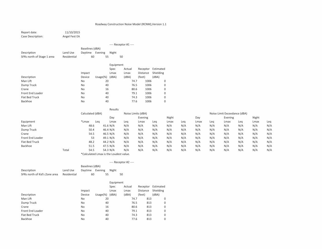
Roadway Construction Noise Model (RCNM),Version 1.1
Report date: 11/10/2015Case Description: Angel Fest EA
Receptor #1Baselines (dBA)
Description Land Use Daytime Evening NightSFRs north of Stage 1 area Residential 60 55 50
EquipmentSpec Actual Receptor Estimated
Impact Lmax Lmax Distance ShieldingDescription Device Usage(%) (dBA) (dBA) (feet) (dBA)Man Lift No 20 74.7 1006 0Dump Truck No 40 76.5 1006 0Crane No 16 80.6 1006 0Front End Loader No 40 79.1 1006 0Flat Bed Truck No 40 74.3 1006 0Backhoe No 40 77.6 1006 0
ResultsCalculated (dBA) Noise Limits (dBA) Noise Limit Exceedance (dBA)
Day Evening Night Day Evening NightEquipment *Lmax Leq Lmax Leq Lmax Leq Lmax Leq Lmax Leq Lmax Leq Lmax LeqMan Lift 48.6 41.6 N/A N/A N/A N/A N/A N/A N/A N/A N/A N/A N/A N/ADump Truck 50.4 46.4 N/A N/A N/A N/A N/A N/A N/A N/A N/A N/A N/A N/ACrane 54.5 46.5 N/A N/A N/A N/A N/A N/A N/A N/A N/A N/A N/A N/AFront End Loader 53 49.1 N/A N/A N/A N/A N/A N/A N/A N/A N/A N/A N/A N/AFlat Bed Truck 48.2 44.2 N/A N/A N/A N/A N/A N/A N/A N/A N/A N/A N/A N/ABackhoe 51.5 47.5 N/A N/A N/A N/A N/A N/A N/A N/A N/A N/A N/A N/A
Total 54.5 54.3 N/A N/A N/A N/A N/A N/A N/A N/A N/A N/A N/A N/A*Calculated Lmax is the Loudest value.
Receptor #2Baselines (dBA)
Description Land Use Daytime Evening NightSFRs north of Kid's Zone area Residential 60 55 50
EquipmentSpec Actual Receptor Estimated
Impact Lmax Lmax Distance ShieldingDescription Device Usage(%) (dBA) (dBA) (feet) (dBA)Man Lift No 20 74.7 813 0Dump Truck No 40 76.5 813 0Crane No 16 80.6 813 0Front End Loader No 40 79.1 813 0Flat Bed Truck No 40 74.3 813 0Backhoe No 40 77.6 813 0

ResultsCalculated (dBA) Noise Limits (dBA) Noise Limit Exceedance (dBA)
Day Evening Night Day Evening NightEquipment *Lmax Leq Lmax Leq Lmax Leq Lmax Leq Lmax Leq Lmax Leq Lmax LeqMan Lift 50.5 43.5 N/A N/A N/A N/A N/A N/A N/A N/A N/A N/A N/A N/ADump Truck 52.2 48.2 N/A N/A N/A N/A N/A N/A N/A N/A N/A N/A N/A N/ACrane 56.3 48.4 N/A N/A N/A N/A N/A N/A N/A N/A N/A N/A N/A N/AFront End Loader 54.9 50.9 N/A N/A N/A N/A N/A N/A N/A N/A N/A N/A N/A N/AFlat Bed Truck 50 46 N/A N/A N/A N/A N/A N/A N/A N/A N/A N/A N/A N/ABackhoe 53.3 49.4 N/A N/A N/A N/A N/A N/A N/A N/A N/A N/A N/A N/A
Total 56.3 56.1 N/A N/A N/A N/A N/A N/A N/A N/A N/A N/A N/A N/A*Calculated Lmax is the Loudest value.
Receptor #3Baselines (dBA)
Description Land Use Daytime Evening NightBeilenson Park west of project siResidential 60 55 50
EquipmentSpec Actual Receptor Estimated
Impact Lmax Lmax Distance ShieldingDescription Device Usage(%) (dBA) (dBA) (feet) (dBA)Man Lift No 20 74.7 2710 0Dump Truck No 40 76.5 2710 0Crane No 16 80.6 2710 0Front End Loader No 40 79.1 2710 0Flat Bed Truck No 40 74.3 2710 0Backhoe No 40 77.6 2710 0
ResultsCalculated (dBA) Noise Limits (dBA) Noise Limit Exceedance (dBA)
Day Evening Night Day Evening NightEquipment *Lmax Leq Lmax Leq Lmax Leq Lmax Leq Lmax Leq Lmax Leq Lmax LeqMan Lift 40 33 N/A N/A N/A N/A N/A N/A N/A N/A N/A N/A N/A N/ADump Truck 41.8 37.8 N/A N/A N/A N/A N/A N/A N/A N/A N/A N/A N/A N/ACrane 45.9 37.9 N/A N/A N/A N/A N/A N/A N/A N/A N/A N/A N/A N/AFront End Loader 44.4 40.5 N/A N/A N/A N/A N/A N/A N/A N/A N/A N/A N/A N/AFlat Bed Truck 39.6 35.6 N/A N/A N/A N/A N/A N/A N/A N/A N/A N/A N/A N/ABackhoe 42.9 38.9 N/A N/A N/A N/A N/A N/A N/A N/A N/A N/A N/A N/A
Total 45.9 45.6 N/A N/A N/A N/A N/A N/A N/A N/A N/A N/A N/A N/A*Calculated Lmax is the Loudest value.
Receptor #4Baselines (dBA)
Description Land Use Daytime Evening NightSFRs east of project site Residential 60 55 50
EquipmentSpec Actual Receptor Estimated
Impact Lmax Lmax Distance Shielding
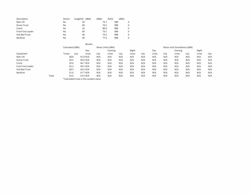
Description Device Usage(%) (dBA) (dBA) (feet) (dBA)Man Lift No 20 74.7 988 0Dump Truck No 40 76.5 988 0Crane No 16 80.6 988 0Front End Loader No 40 79.1 988 0Flat Bed Truck No 40 74.3 988 0Backhoe No 40 77.6 988 0
ResultsCalculated (dBA) Noise Limits (dBA) Noise Limit Exceedance (dBA)
Day Evening Night Day Evening NightEquipment *Lmax Leq Lmax Leq Lmax Leq Lmax Leq Lmax Leq Lmax Leq Lmax LeqMan Lift 48.8 41.8 N/A N/A N/A N/A N/A N/A N/A N/A N/A N/A N/A N/ADump Truck 50.5 46.6 N/A N/A N/A N/A N/A N/A N/A N/A N/A N/A N/A N/ACrane 54.6 46.7 N/A N/A N/A N/A N/A N/A N/A N/A N/A N/A N/A N/AFront End Loader 53.2 49.2 N/A N/A N/A N/A N/A N/A N/A N/A N/A N/A N/A N/AFlat Bed Truck 48.3 44.4 N/A N/A N/A N/A N/A N/A N/A N/A N/A N/A N/A N/ABackhoe 51.6 47.7 N/A N/A N/A N/A N/A N/A N/A N/A N/A N/A N/A N/A
Total 54.6 54.4 N/A N/A N/A N/A N/A N/A N/A N/A N/A N/A N/A N/A*Calculated Lmax is the Loudest value.
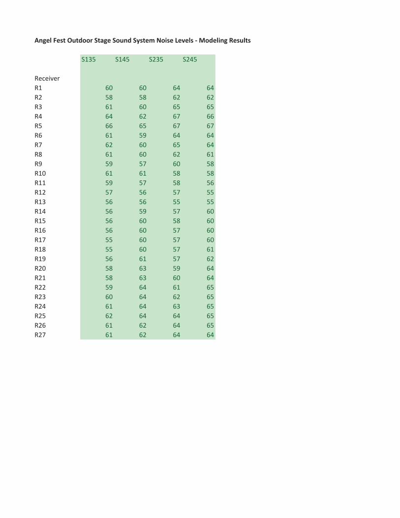
Angel Fest Outdoor Stage Sound System Noise Levels Modeling Results
S135 S145 S235 S245
ReceiverR1 60 60 64 64R2 58 58 62 62R3 61 60 65 65R4 64 62 67 66R5 66 65 67 67R6 61 59 64 64R7 62 60 65 64R8 61 60 62 61R9 59 57 60 58R10 61 61 58 58R11 59 57 58 56R12 57 56 57 55R13 56 56 55 55R14 56 59 57 60R15 56 60 58 60R16 56 60 57 60R17 55 60 57 60R18 55 60 57 61R19 56 61 57 62R20 58 63 59 64R21 58 63 60 64R22 59 64 61 65R23 60 64 62 65R24 61 64 63 65R25 62 64 64 65R26 61 62 64 65R27 61 62 64 64

AngelFest 150107
Draft Environmental Assessment April 2016
APPENDIX C Traffic Management Plan

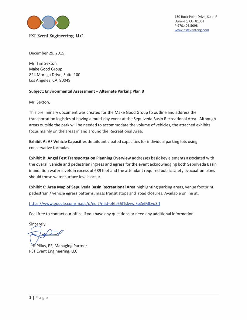
150 Rock Point Drive, Suite F Durango, CO 81301 P 970.403.5098 www.psteventeng.com
PPST Event Engineering, LLC
1 | P a g e
December 29, 2015
Mr. Tim Sexton Make Good Group 824 Moraga Drive, Suite 100 Los Angeles, CA 90049 Subject: Environmental Assessment – Alternate Parking Plan B Mr. Sexton,
This preliminary document was created for the Make Good Group to outline and address the transportation logistics of having a multi-day event at the Sepulveda Basin Recreational Area. Although areas outside the park will be needed to accommodate the volume of vehicles, the attached exhibits focus mainly on the areas in and around the Recreational Area.
Exhibit A: AF Vehicle Capacities details anticipated capacities for individual parking lots using conservative formulas.
Exhibit B: Angel Fest Transportation Planning Overview addresses basic key elements associated with the overall vehicle and pedestrian ingress and egress for the event acknowledging both Sepulveda Basin inundation water levels in excess of 689 feet and the attendant required public safety evacuation plans should those water surface levels occur.
Exhibit C: Area Map of Sepulveda Basin Recreational Area highlighting parking areas, venue footprint, pedestrian / vehicle egress patterns, mass transit stops and road closures. Available online at:
https://www.google.com/maps/d/edit?mid=zEts66fTskvw.kpZeIMLyu3fI
Feel free to contact our office if you have any questions or need any additional information.
Sincerely, Jeff Pillus, PE, Managing Partner PST Event Engineering, LLC
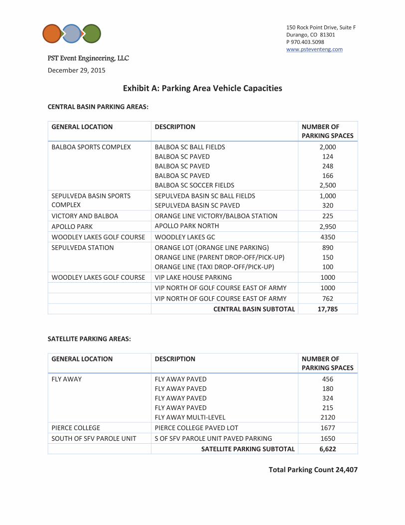
150 Rock Point Drive, Suite F Durango, CO 81301 P 970.403.5098 www.psteventeng.com
PPST Event Engineering, LLC
December 29, 2015
Exhibit A: Parking Area Vehicle Capacities
CENTRAL BASIN PARKING AREAS:
GENERAL LOCATION DESCRIPTION NUMBER OF PARKING SPACES
BALBOA SPORTS COMPLEX BALBOA SC BALL FIELDS BALBOA SC PAVED BALBOA SC PAVED BALBOA SC PAVED BALBOA SC SOCCER FIELDS
2,000 124 248 166
2,500 SEPULVEDA BASIN SPORTS COMPLEX
SEPULVEDA BASIN SC BALL FIELDS SEPULVEDA BASIN SC PAVED
1,000 320
VICTORY AND BALBOA ORANGE LINE VICTORY/BALBOA STATION 225 APOLLO PARK APOLLO PARK NORTH 2,950 WOODLEY LAKES GOLF COURSE WOODLEY LAKES GC 4350 SEPULVEDA STATION ORANGE LOT (ORANGE LINE PARKING)
ORANGE LINE (PARENT DROP-OFF/PICK-UP) ORANGE LINE (TAXI DROP-OFF/PICK-UP)
890 150 100
WOODLEY LAKES GOLF COURSE VIP LAKE HOUSE PARKING 1000 VIP NORTH OF GOLF COURSE EAST OF ARMY 1000 VIP NORTH OF GOLF COURSE EAST OF ARMY 762 CENTRAL BASIN SUBTOTAL 17,785
SATELLITE PARKING AREAS:
GENERAL LOCATION DESCRIPTION NUMBER OF PARKING SPACES
FLY AWAY FLY AWAY PAVED FLY AWAY PAVED FLY AWAY PAVED FLY AWAY PAVED FLY AWAY MULTI-LEVEL
456 180 324 215
2120 PIERCE COLLEGE PIERCE COLLEGE PAVED LOT 1677 SOUTH OF SFV PAROLE UNIT S OF SFV PAROLE UNIT PAVED PARKING 1650 SATELLITE PARKING SUBTOTAL 6,622
Total Parking Count 24,407
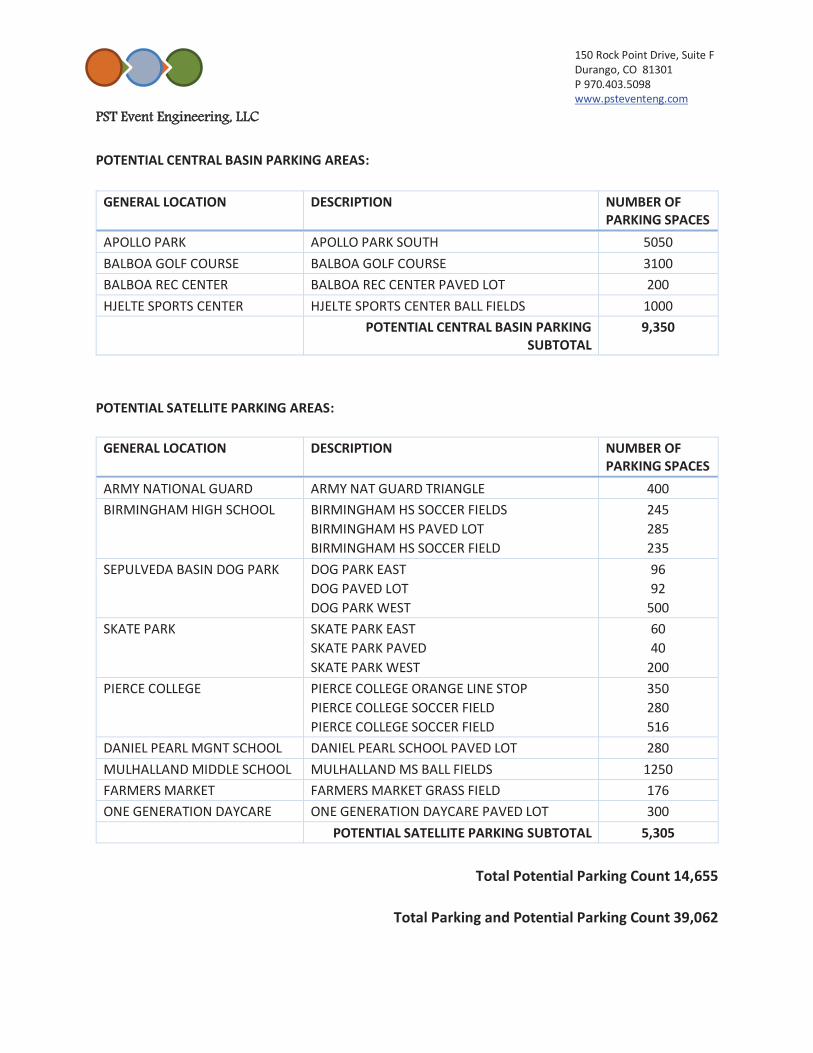
150 Rock Point Drive, Suite F Durango, CO 81301 P 970.403.5098 www.psteventeng.com
PPST Event Engineering, LLC
POTENTIAL CENTRAL BASIN PARKING AREAS:
GENERAL LOCATION DESCRIPTION NUMBER OF PARKING SPACES
APOLLO PARK APOLLO PARK SOUTH 5050 BALBOA GOLF COURSE BALBOA GOLF COURSE 3100 BALBOA REC CENTER BALBOA REC CENTER PAVED LOT 200 HJELTE SPORTS CENTER HJELTE SPORTS CENTER BALL FIELDS 1000 POTENTIAL CENTRAL BASIN PARKING
SUBTOTAL 9,350
POTENTIAL SATELLITE PARKING AREAS:
GENERAL LOCATION DESCRIPTION NUMBER OF PARKING SPACES
ARMY NATIONAL GUARD ARMY NAT GUARD TRIANGLE 400 BIRMINGHAM HIGH SCHOOL BIRMINGHAM HS SOCCER FIELDS
BIRMINGHAM HS PAVED LOT BIRMINGHAM HS SOCCER FIELD
245285 235
SEPULVEDA BASIN DOG PARK DOG PARK EAST DOG PAVED LOT DOG PARK WEST
96 92
500 SKATE PARK SKATE PARK EAST
SKATE PARK PAVED SKATE PARK WEST
60 40
200 PIERCE COLLEGE PIERCE COLLEGE ORANGE LINE STOP
PIERCE COLLEGE SOCCER FIELD PIERCE COLLEGE SOCCER FIELD
350 280 516
DANIEL PEARL MGNT SCHOOL DANIEL PEARL SCHOOL PAVED LOT 280 MULHALLAND MIDDLE SCHOOL MULHALLAND MS BALL FIELDS 1250 FARMERS MARKET FARMERS MARKET GRASS FIELD 176 ONE GENERATION DAYCARE ONE GENERATION DAYCARE PAVED LOT 300 POTENTIAL SATELLITE PARKING SUBTOTAL 5,305
Total Potential Parking Count 14,655
Total Parking and Potential Parking Count 39,062
150 Rock Point Drive, Suite FDurango, CO 81301 P 970.403.5098 www.psteventeng.com
PPST Event Engineering, LLC
Exhibit B: AngelFest Transportation Planning Overview
Angel Fest is a 3-day music, arts and food festival to be held on a portion of the Sepulveda Basin Recreational Area. The event will be scheduled for a Friday, Saturday, and Sunday in October of 2016 (dates TBD). Anticipated hours of operation will be from 10 AM - 11 PM. Transportation Plan Overview based on 65,000 patrons and will require a detailed Transportation Plan to cover the following topics:
1. Parking Capacities 2. Vehicle ingress and egress 3. Pedestrian Circulation 4. Potential effects on local background traffic including road closures 5. Taxi - Parent pickup and drop-off, Uber Taxi program 6. Mass transit availability to handle anticipated event volumes 7. Development of a shuttle plan for offsite parking and accommodation of private charter
buses 1. Parking Capacities
The following formulas are based on typical industry standards for similar events: 65,000 expected attendance
-13,000 20% expected mass transit use - 3,250 5% pickup / drop-off program - 3,250 5% private charter buses (specialty programs) - 1,950 3% expected taxi & Uber taxi service (-21,450) combined programs 43,550 patrons needing parking divided by 2.4 persons per vehicle = 18,000 approximate parking spaces needed
As shown in Exhibit A and the digital map there are approximately 24,400 potential parking
spaces in and around the vicinity of the festival grounds. Of the onsite parking spaces needed, a minimum of 254 ADA compliant spaces will be needed
with 43 of them being van accessible. Two dirt lots exist on Woodley Ave., directly west of venue each potentially holds up to 480
bicycles. 2. Vehicle ingress and egress
Ingress: Parking passes will be sold in advance and will consist of color coded hang tags matching color coded designated parking areas. The passes will have directions and traffic patterns printed on the back to assist patrons and event staff in getting patrons to the appropriate lots.
Egress: Signage and traffic personnel will be used to direct traffic away from the site onto major City streets that have direct access to main arteries and freeways. See GIS map for details.

150 Rock Point Drive, Suite FDurango, CO 81301 P 970.403.5098 www.psteventeng.com
PPST Event Engineering, LLC
3. Pedestrian Circulation
A Pedestrian Circulation Plan will be developed for agency review to describe pedestrian crossings and safety measures at main roadways. The plan will expedite event ingress while minimizing impacts to background traffic.
To facilitate pedestrian safety, Woodley Ave. is to be closed to all non-event traffic (with the exception of emergency services, shuttle buses and law enforcement) between the entrance to Woodley Lakes Golf Course and a point 900 feet north of Burbank Boulevard, from Thursday prior to show through Monday time TBD.
Pedestrians leaving the site and going to the following parking/pick-up/drop-off areas will use the described pedestrian routes:
o The Van Nuys R/C lot and private charter/shuttle bus areas will cross Woodley Ave. north of the wye intersection into the R/C Airstrip and proceed north/south following signage to designated areas.
o Woodley GC lot, UBER program area, Balboa Sports Complex lot and Sepulveda Sports Complex lot will cross Woodley Ave. south of the golf course entrance and proceed north and west following signage and marked crossings to designated areas.
o Parent/Taxi Area will exit the venue following signage and proceed north on Woodley Ave. and make a right on the Orange Line bike path and continue approximately one mile to the Orange Line Parking lot located next to LA Fitness.
4. Potential effects on local background traffic including road closures.
Potential road closures for entire three days Haskell from Victory south to Sepulveda. Potential road closures for egress Friday, Saturday and Sunday 10:30pm - 1:00am
o Burbank west from Sepulveda to Hayvenhurst Ave. o Victory east from Balboa to the 405 Freeway
Woodley Ave. is to be closed to non-event traffic beginning Thursday prior to show, reopening Monday PM.
A Hang Tag Program for neighbors and local businesses is to be implemented with road blocks and checkpoints to discourage festival goers from entering local neighborhoods during event.
In the event of Basin inundation and water surface levels exceed 689 feet, street closures and all traffic will follow ASACE Sepulveda Basin public safety evacuation guidelines. Vehicles from parking areas in Woodley Lakes Golf Course and Apollo Park are diverted north on Woodley Avenue to north of Victory Blvd. Parking areas along Balboa Blvd. are similarly diverted north on Balboa Blvd.
5. Taxi, Parent pickup and drop-off, Uber Taxi Program
Uber taxi location at Orange Line lot corner or Balboa and Victory Taxi and parent pickup / drop off at Orange Line lot at Erwin and Sepulveda
6. Mass transit availability to handle volumes.
Metro Orange Line stops at Woodley Park, Balboa & Victory, Sepulveda & Haskell Metro Orange Local has 6 stops on Victory Blvd. all within walking distance of venue Amtrak Station at Van Nuys Blvd & Saticoy (3.5 mile bus ride) Metro Link Stations at both Van Nuys Blvd & Saticoy and CSU-Northridge
150 Rock Point Drive, Suite FDurango, CO 81301 P 970.403.5098 www.psteventeng.com
PPST Event Engineering, LLC
7. Development of shuttle plan for offsite parking and accommodation of private charter buses: Shuttle load / unload at site on Woodley south of wye intersection Shuttle buses staging area on site at R/C airstrip Shuttle pickup & drop-off areas:
o Amtrak & Metro Link at Van Nuys & Saticoy and CSU-Northridge o Pierce College and Orange Line Parking at Pierce College o Van Nuys Fly Away o Veterans Center (Westwood) o Universal Studios o Valley College o Calabasas (MPTF Campus) o Santa Clarita o Burbank o Pasadena o Downtown LA o East LA Community College o South Bay o The Forum (Inglewood) o Balboa & Stagg St. o Greater Los Angeles VA
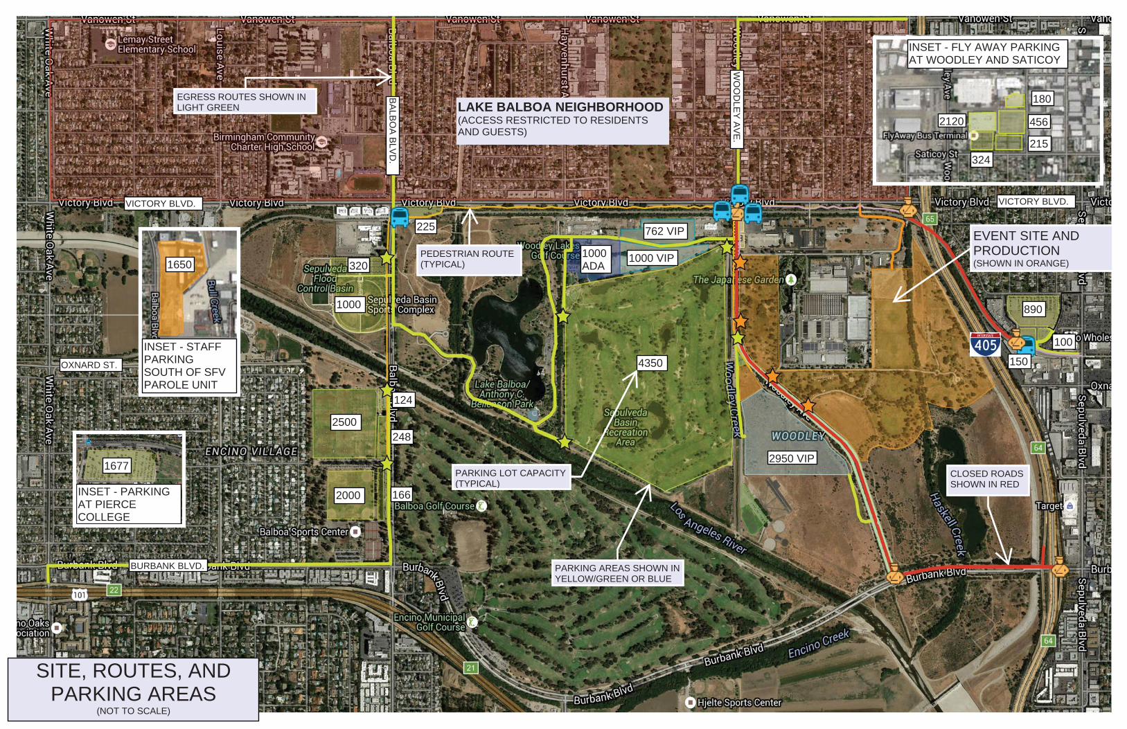
IINSET FLY AWAY PARKING AREA(NORTH ON WOODLEY AT SATICOY)
EGRESS ROUTES SHOWN INLIGHT GREEN LAKE BALBOA NEIGHBORHOOD
(ACCESS RESTRICTED TO RESIDENTSAND GUESTS)
1000
320
2500
2000
124
248
166
762 VIP
1000 VIP1000ADA
4350
2950 VIP
890
100
150
INSET - FLY AWAY PARKINGAT WOODLEY AND SATICOY
INSET - STAFFPARKINGSOUTH OF SFVPAROLE UNIT
INSET - PARKINGAT PIERCECOLLEGE
SITE, ROUTES, ANDPARKING AREAS
(NOT TO SCALE)
BURBANK BLVD.
VICTORY BLVD.
OXNARD ST.
VICTORY BLVD.
WO
OD
LEY
AV
E.
BA
LBO
A B
LVD
.
EVENT SITE ANDPRODUCTION(SHOWN IN ORANGE)
180
456
215
2120
324
1650
1677CLOSED ROADSSHOWN IN RED
PEDESTRIAN ROUTE(TYPICAL)
PARKING AREAS SHOWN INYELLOW/GREEN OR BLUE
PARKING LOT CAPACITY(TYPICAL)
225

AngelFest 150107
Draft Environmental Assessment April 2016
APPENDIX D Environmental Commitments
To further reduce any potential impacts from the implementation of the Proponent’s Preferred Alternative, the following Environmental Commitments would be implemented:
Physical Land Resources PLR-1 The Proponent will water all unpaved areas to minimize soil erosion as
needed. All unpaved areas will be watered down prior to opening for use each day to minimize fugitive dust.
PLR-2 To reduce potential erosion, areas disturbed by the event would be immediately returned to pre-event conditions by re-vegetating as appropriate. As necessary to restore prior conditions, barren areas would be seeded and/or planted with native vegetation.
PLR-3 Areas along Woodley Creek and Haskell Creek will be fenced to ensure no substantial erosion affects the sensitive waterways.
PLR-4 No ground disturbing activities (other than fence posting) within the sensitive wildlife areas will occur.
PLR-5 Double fencing to ensure no access along the boundaries of Haskell Creek and to protect the adjacent Sepulveda Basin Wildlife Area will be implemented to protect sensitive areas from potential erosion.
PLR-6 Grading and construction activities shall not be conducted during a rain event. Workers and equipment shall be removed from the area until the cessation of rain.
PLR-7 Emergency access routes will be identified as part of the development of the emergency response plan based on input from emergency responders to address an emergency such as an earthquake.
AngelFest 150107
Draft Environmental Assessment April 2016
Water Resources
WR-1 To minimize potential impacts should a rain event occur, the setup and breakdown will be phased to the extent feasible such that areas in lower parts of the Basin, which are more susceptible to flooding, will be installed last and removed first, thus minimizing the time floatable debris is located in the lowest parts of the Basin. Locations of port-o-johns will also be located in areas of higher elevations to the extent feasible.
WR-2 The Festival Proponent or organizer (RAP or Make Good Group) will prepare a final evacuation/emergency response plan in coordination with emergency response providers (LAPD/LAFD) and the Corps Safety Office. The plan will include rainfall monitoring of the National Oceanic and Atmospheric Administration (NOAA) Quantitative Precipitation Forecast (QPF) with potential for evacuation where forecast events exceed 0.5 inches of rain in a day. The plan will be consistent with Corps Engineer Manual 385-1-1, where applicable. The plan will address all protocols for response to public safety matters including weather, an accidental hazardous material exposure, earthquakes, early warning intelligence indicating the potential need to evacuate, and other conditions. The plan will be developed during the detailed planning phase of the Festival as directed by the emergency responders. The emergency response plan will include, for example:
Evacuation details and routes for various emergency scenarios; Rain forecast event cancellation details; How emergency announcements will be broadcasted; How the shuttle system could be utilized as part of the evacuation
process; Setup and breakdown procedures in the event of a significant
emergency; and Human health emergency response.
WR-3 Consistent with the evacuation/emergency response plan to be prepared (EC WR-2), RAP and the Festival Proponent will be immediately notified and all activities will be suspended if a rain event is forecast of 0.5 inches or greater in any 24-hour period for any of the event days, including all days of setup, the three (3) Festival days, or the breakdown days.
WR-4 A temporary six foot high chain-link fence will be installed around the Proposed Project Site to prevent debris from being tossed into Haskell Creek. Fencing along Haskell Creek and Woodley Creek, which are interior to the Proposed Project Site, will run along the length of the water features through the entirety within the Proposed Project Site, and there would be no access by event staff or Festival attendees during the Festival. There will be limited designated spots where attendees can pass through. Silt fencing will be placed
AngelFest 150107
Draft Environmental Assessment April 2016
along the Festival boundary to minimize debris being washed into the Los Angeles River.
WR-5 Complete litter removal would be conducted within the affected water features including Haskell Creek and the Wildlife Area Lake in coordination with and under the direction of the RAP and the Corps.
WR-6 Fluids released because of spills, equipment failure (broken hose, punctured
tank) or refueling will be immediately controlled, contained, and cleaned-up per Federal and state regulations. All contaminated materials will be disposed of promptly and properly to prevent contamination of the site.
Air Quality AQ-1 A Fugitive Dust Emission Control Plan would be developed and implemented.
Measures to be incorporated into the plan would include:
All unpaved areas will be watered down prior to opening for use each day to minimize fugitive dust (consistent with ER PLR-1).
Install wheel washers/cleaners or wash the wheels of trucks and other heavy equipment where vehicles exit the site or unpaved access roads.
Increase the frequency of watering, or implement other additional fugitive dust mitigation measures, of all disturbed fugitive dust emission sources when wind speeds (as instantaneous wind gusts) exceed 20 miles per hour.
AQ-2 All refuse generated at the Proposed Project Site will be stored in covered
containers and removed at regular intervals in compliance with solid waste regulations to ensure no objectionable odors affecting a substantial number of people would result from the Festival.
AQ-3 All on-road construction vehicles will meet all applicable California on-road emission standards and will be licensed in the State of California. This does not apply to construction worker personal vehicles.
AQ-4 All off-road construction diesel engines not registered under California Air Resources Board’s Statewide Portable Equipment Registration Program, which have a rating of 50 horsepower or more, shall meet, at a minimum, the Tier 3 California Emission Standards for Off-road Compression-Ignition Engines as specified in California Code of Regulations, Title 13, Section 2423(b)(1). If a Tier 3 or Tier 3-equivalent engine is not available for a particular item of equipment, Tier 2 compliant engines shall be allowed on a case by case basis.
AngelFest 150107
Draft Environmental Assessment April 2016
AQ-5 Idling of heavy-duty diesel trucks during loading and unloading shall be limited to five minutes; auxiliary power units will be used whenever possible. State law requires drivers of diesel fueled commercial vehicles weighing more than 10,000 pounds:
Shall not idle a diesel-fueled auxiliary power system (APS) for more than 5 minutes to power a heater, air conditioner, or any ancillary equipment on the vehicle if you have a sleeper berth and you are within 100 feet of a restricted area (homes and schools).
Construction worker trips should be minimized by requiring carpooling and by providing for lunch onsite.
Water or use environmentally safe chemical stabilization to treat the earthen fill storage piles to create stabilized surfaces that will minimize wind erosion emissions.
Limit vehicle speeds on the Proposed Action Site unpaved roads to 10 mph.
Noise N-1 All equipment used will be muffled and maintained in good operating
condition. All internal combustion engine driven equipment will be fitted with well-maintained mufflers in accordance with manufacturer’s recommendations.
N-2 A toll-free telephone number shall be established for dealing with public concerns/ complaints about noise and other project-related issues.
N-3 As part of the Proposed Action’s advanced notification to all residences and property owners, a contact person name and phone number shall be provided. The contact person shall respond to questions or concerns related to noise and vibration within 24 hours. If warranted by inquiries or complaints, on-site noise measurements shall be taken to determine if noise or vibration levels are substantially greater than expected levels.
N-4 All equipment shall include noise reduction measures, as applicable. These measures shall include, but may not be limited to, properly operating and maintaining mufflers, correct placement of equipment engine covers, and ensuring that small loading equipment is equipped with rubber tires.
N-5 All machinery shall be equipped with the best available exhaust mufflers and “hush kits,” as applicable.
N-6 Noise producing signals, including horns, whistles, alarms, and bells shall be limited to safety warning purposes only.
N-7 All measures described in Section 2.3.1.4 of the draft EA will be implemented for the applicable sound systems.
AngelFest 150107
Draft Environmental Assessment April 2016
N-8 The stage design will include sound absorbing materials at each stage to further minimize any noise. These materials would be placed on the stage roof, rear of stage, and areas behind the loudspeaker arrays. Estimated sound reduction in areas behind stages would be between 2 and 3 dB.
N-9 During the two (2) weeks prior to the Festival setup beginning, ambient noise
levels will be recorded at four (4) designated locations, as designated by a Corps biologist, within the Wildlife Area at least three times a week to document pre-Festival conditions. One (1) recording each week will occur during a weekend day, and the other two (2) will occur during a weekday. Monitoring will occur hourly from 12:00 p.m. until 11:00 p.m. to coincide with the hours music would be played at the Festival.
During one (1) week of the setup period, noise levels will be recorded in the same manner as above to document setup noise conditions.
Throughout the three (3) Festival days, noise monitors will monitor sound levels in real time both at the Front of House and at up to three (3) strategic locations within the communities adjacent to the Festival site and at the four (4) locations within the Wildlife Area previously identified by the Corps biologist. The monitoring within the Wildlife Area will be conducted at least hourly from when the music starts until it ends (11:00 p.m. on Friday and Saturday, 9:45 p.m. on Sunday). This real-time noise monitoring will create logs and records to document actual sound levels during the course of the Festival, and will be consulted in the event of complaints. The sound monitors will have both a sound level meter and a communication device that can be used to report back to the production manager when sound levels exceed sited goals. The monitoring results will also be used to inform the Corps, RAP, and Festival Proponent, and if noise reaches levels exceed wildlife or community standards, adjustments in volume will be made to keep the noise within those standards. The wildlife standard is 83 dBA and the community standard is 67 dBA.
Wildlife BIO-1
Impacts to native vegetation shall be avoided to the greatest extent feasible. When clearing the ground vegetation within the model airplane field and corn
maze, methods that do not remove plant roots or disturb the soil such as mowing or weed whipping will be used to preserve the underground plant parts and seed bank within the top few inches of the soil, so that natural re-growth and establishment (i.e., seed germination) can occur following the completion of the Festival.
BIO-2 To minimize the impact to wildlife movement within the Sepulveda Basin Wildlife Area, lighting and sound systems will be directed away from Haskell Creek and away from the undeveloped areas of the Sepulveda Basin Wildlife
AngelFest 150107
Draft Environmental Assessment April 2016
Area to the greatest extent feasible. All lighting systems, including those used for the Festival at the Woodley Municipal Golf Course parking area, will point in a downward direction to reduce light spillage onto areas that could be used by wildlife.
BIO-3 Pre-Festival
In coordination with a Corps’ biologist, a knowledgeable, experienced qualified biologist will conduct nocturnal (nighttime) surveys in the Proposed Project Site three (3) times each week for the four (4) weeks preceding the start of Festival set-up to identify owls and nightjars, such as the lesser nighthawk. The 12 surveys should be evenly spaced apart.
Bat surveys must be accomplished by a qualified, experienced and knowledgeable bat biologist over the same period discussed above for nocturnal birds.
All data collection locations shall be documented using GPS in GIS format (geo-database or shapefile) project must be California Stateplane Zone 5, NAD83 for both pre and post surveys.
In coordination with the Corps biologist, a knowledgeable, experienced qualified biologist will conduct diurnal surveys in the Proposed Project Site three (3) times each week for four (4) weeks prior to the start of Festival setup to identify raptors over the entire Sepulveda Basin, including within grasslands, shrublands, and riparian forest areas. The 12 surveys should be evenly spaced apart and the locations of any sensitive wildlife shall be documented. These surveys shall follow a “strip transect” or “areas search” method to be determined prior to surveys commencing.
Waterbird surveys will be accomplished separately from other bird surveys. Waterbird surveys will be accomplished at the same frequency and on the time and period schedule as discussed above and observe use of the lake (i.e., roosting, foraging).
Post-Festival
Following the complete removal of all Festival equipment, in coordination with a Corps’ biologist, a knowledgeable, experienced qualified biologist will conduct nocturnal surveys in the proposed Project Site three (3) times each week for the four (4) weeks to identify owl and nightjar, such as lesser nighthawk. The 12 surveys should be evenly spaced apart.
Waterbird surveys will be accomplished separately from other bird surveys. Waterbird surveys will be accomplished at the same frequency and on the time and period schedule as discussed above and observe use of the lake (i.e., roosting, foraging).
In coordination with the Corps biologists, a knowledgeable, experienced qualified biologist will conduct diurnal surveys in the Proposed project site three (3) times each week for four (4) weeks following the complete removal of all Festival equipment to identify raptors over the entire
AngelFest 150107
Draft Environmental Assessment April 2016
Wildlife Areas, including within grasslands, shrublands, and riparian forest areas. The 12 surveys should be evenly spaced apart and the locations of any sensitive wildlife shall be documented. These surveys shall follow a “strip transect” or “areas search” method to be determined prior to surveys commencing.
A draft report documenting all surveys shall be sent to a Corps’ biologist within 30 days of the last survey.
The Corps senior ecologist will determine based on resumes, those who are knowledgeable, experienced, and qualified biologists.
All data collection locations shall be documented using GPS in GIS format (geo-database or shapefile) project must be California Stateplane Zone 5, NAD83 for both pre, during, and post surveys.
BIO-4 Construction of a ramp providing stage access at the southern end of the
Festival will avoid all oak trees, regardless of their size. Oak trees within the undeveloped areas of the Sepulveda Basin Wildlife Area
that are vulnerable to impacts from the stage and ramp construction will be fenced with high-visibility fencing (e.g., orange mesh snow drift fencing) and avoided as best practicable.
BIO-5 High visibility snow-drift fencing would be placed along the western perimeter of the Wildlife Area along Woodley Avenue between the Festival’s southern boundary and Burbank Boulevard to discourage festival attendees from entering the Wildlife Area during the Festival.
BIO-6
The Festival Proponent or organizer (RAP or Make Good Group) will restore the site to pre-event conditions or better, including by restoring turf, removing fence and parking lot barrier replacements and repairing any damages, restoring the cricket fields and other fields and replacing damaged shrubs and trees.
If determined necessary by a RAP arborist, any oak tree damaged during the Festival shall be replaced with a 15 gallon tree of the same species within the Wildlife Area north of Burbank Boulevard. The replacement tree shall be derived from a local source or obtained from a local nursery and shall be maintained by the RAP for a minimum of three (3) years. A report shall be prepared by the Proposed Project Proponent or Festival organizer following the three-year maintenance period and submitted to the Corps’ biologist to verify that all replacement trees are established and sustaining without supplemental irrigation. Any replacement tree that dies during the three year maintenance period shall be replaced and maintained for an additional three years, followed by a report to the Corps that documents the tree establishment.
AngelFest 150107
Draft Environmental Assessment April 2016
Cultural Resources C-1 If previously unknown cultural resources are uncovered, work in the
immediate area would cease until the requirements in 36 C.F.R. §800.13 are complied with. The on-site supervisor shall contact an approved archaeological consultant immediately. The on-site supervisor shall additionally divert all project-related activities to other areas until the discovery has been evaluated by the approved archaeological consultant, who will determine if further actions are warranted.
Hazardous and Toxic Waste Materials HW-1 Compliance with all applicable local, regional, state, and Federal laws,
policies, and regulations regarding the transportation, storage, handling, management, and disposal of hazardous materials and wastes.
HW-2 The Festival Proponent shall prepare Solid and Hazardous Materials and
Waste Management Plan.
HW-3 The Festival Proponent shall have in place an accidental spill prevention and response plan for all hazardous materials that may be used on site. In the event of a spill or release of hazardous substances, the contaminated soil shall be immediately contained, excavated and treated per Federal and State regulations developed by the EPA, as well as local hazardous waste ordinances.
HW-4 During Festival set-up or breakdown, should an area of suspected contamination be encountered, construction activity in the area shall cease and soil sampling shall be conducted to determine the nature and extent of the potential contamination. If testing indicates that contamination does exist, the area shall be cleaned up in accordance with applicable Federal and State regulations.
HW-5 If requested by the emergency response providers, a Fire Incident Plan shall be prepared with the LAFD that will describe the LAFD operating conditions and emergency response in case of an accidental spill.
HW-6 A Private Emergency Medical Services Plan shall be coordinated with private emergency medical personnel to be present during the festivities to respond onsite to hazardous conditions.
HW-7 To ensure the safety of the public with pyrotechnics, the Festival Proponent or organizer (RAP or Make Good Group) shall obtain any necessary permits from the LAFD to allow the use of fireworks and to include any provisions, such as regulation of the size of firework shells and the fall out area. Any use of fireworks or pyrotechnics will also be coordinated with the Corps Safety Office.
AngelFest 150107
Draft Environmental Assessment April 2016
Traffic T-1 A final traffic and parking management plan shall be prepared for the Festival
to ensure that adverse effects on traffic (including transit and pedestrian) conditions (congestion and safety), are minimized. The plan shall be submitted to LADOT special events division in advance of beginning setup for the Festival, after thorough coordination to ensure it meets the needs of the community, LADOT, transit providers, and safety providers.
T-2 The final traffic and parking plan, as approved by LADOT, shall be implemented during all phases of the event: setup, the Festival, and breakdown.
T-3 Public streets shall be kept operational to the extent possible, particularly during the morning and evening peak hours of traffic. If required, any lane closures would be minimized during peak traffic hours.
T-4 If damage to roads occurs, the Festival Proponent shall coordinate repairs with the affected public agencies to ensure that any impacts to area roads are adequately repaired. Roads disturbed by trucks or equipment shall be properly restored to ensure long-term protection of road surfaces. Such repairs shall occur as part of the active construction period.
T-5 The Festival Proponent or organizer (RAP or Make Good Group) shall obtain
all applicable permits and clearances from appropriate agencies for transporting and hauling equipment and debris.
Aesthetics
AR-1 Work and staging areas will be kept orderly and free of trash and debris.
AR-2 Vehicular traffic shall be confined to routes of travel to and from the Proposed Project Site, and cross-country vehicle and equipment use outside designated work and storage-staging areas is prohibited.
AR-3 Limit speed of vehicles on dirt routes to minimize the generation of fugitive dust.
Recreation REC-1 The Festival organizer, in coordination with RAP, shall post notices of
upcoming impacts to recreation via signs, newspapers, websites and direct communication to pedestrians, equestrians, and bicyclists and other users at least one week prior to and during Festival setup activities.
AngelFest 150107
Draft Environmental Assessment April 2016
REC-2 There shall be no public access to active work zones during construction activities within fenced areas. “No trespassing” signs shall be posted.
REC-3 The Festival Proponent or organizer shall prepare notices for the Corps’ Public Affairs Office (PAO) to post on the Corps’ website and, if requested, shall prepare a communication plan with frequently asked questions for the Corps’ PAO at least one (1) month prior to Festival set-up.
Public Safety
PS-1 Festival Proponent or organizer shall prepare a Public Safety Management Plan to maintain public health and safety during all phases of the Festival. Components of the plan shall include:
Notifying the public of the location and duration of Festival setup
activities, any closures of pedestrian and bicycle paths and trails, and restrictions on other impacted recreation;
Posting signs locating Festival setup areas and warning of the presence of construction equipment;
Fencing Festival staging areas; and Providing temporary walkways (with appropriate markings, barriers,
and signs to safely separate pedestrians from vehicular traffic) and posting detour signs where a sidewalk or pedestrian or bicycle path or trail would be closed during construction; and
Measures assuring the safety of use of pyrotechnics and fireworks, in particular to minimize the risk of fire and personal injury. The plan will require onsite fire abatement measures and any necessary pyrotechnics and fireworks cancellation requirements, such as in the event of high winds.
PS-2 The Festival Proponent or organizer shall prepare and implement a Worker Health and Safety Plan to be approved by the Corps’ Safety Office prior to start of setup activities. At a minimum the plan would include:
All appropriate worker, public health, and environmental protection
equipment and procedures; Designated heavy equipment traffic circulation route plans; Emergency evacuation routes and procedures; Emergency response procedures; Most direct route to a hospital and safe air ambulance landing zone; Name of the Site Safety Officer; and Documentation that all workers have reviewed and signed the plan.
AngelFest 150107
Draft Environmental Assessment April 2016
PS-3 Festival Proponent shall consult with local jurisdictions to ensure that construction activities do not impede adopted emergency response plans.
PS-4 Prior to Festival set-up activities, the Festival Proponent shall notify relevant fire, police, and traffic management methods to be used to ensure access at all times.
PS-5 All work and staging areas will be clearly marked and appropriately guarded to ensure public safety.
PS-6 No open fires shall be permitted without proper accident prevention measures and smoking would be limited to designated controlled areas.
