alabama historical commission s p s …surface-mining.alabama.gov/p3910r3/data/attachment...
TRANSCRIPT
STATE OF ALABAMA ALABAMA HISTORICAL COMMISSION
468 SOUTH PERRY STREET MONTGOMERY, ALABAMA 36130-0900
FRANK W. WHITE TEL: 334-242-3184 EXECUTIVE DIRECTOR FAX: 334-240-3477
THE STATE HISTORIC PRESERVATION OFFICE WWW.PRESERVEALA.ORG
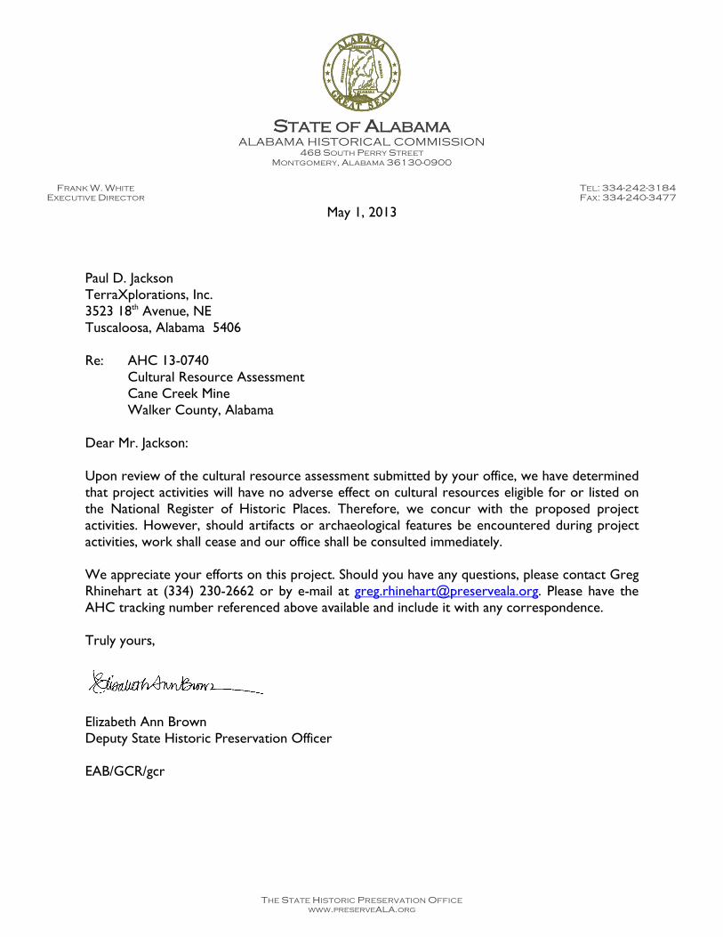
May 1, 2013
Paul D. Jackson TerraXplorations, Inc. 3523 18th Avenue, NE Tuscaloosa, Alabama 5406 Re: AHC 13-0740 Cultural Resource Assessment Cane Creek Mine Walker County, Alabama Dear Mr. Jackson: Upon review of the cultural resource assessment submitted by your office, we have determined that project activities will have no adverse effect on cultural resources eligible for or listed on the National Register of Historic Places. Therefore, we concur with the proposed project activities. However, should artifacts or archaeological features be encountered during project activities, work shall cease and our office shall be consulted immediately. We appreciate your efforts on this project. Should you have any questions, please contact Greg Rhinehart at (334) 230-2662 or by e-mail at [email protected]. Please have the AHC tracking number referenced above available and include it with any correspondence. Truly yours,
Elizabeth Ann Brown Deputy State Historic Preservation Officer EAB/GCR/gcr
- 1TerraXplorations
Prepared by TerraXplorations, Inc.
Prepared for PERC Engineering Company, Inc.
TerraXplorations, Inc.2301 9th Street, Suite 2Tuscaloosa, Alabama 35401www.terraxplorations.com
PERC Engineering Company, Inc.1606 Highway 78 WestP.O. Box 1712Jasper, Alabama 35502-1712
A PHASE I CULTURAL-RESOURCES SURVEYFOR THE PROPOSED CANE CREEK MINE,
WALKER COUNTY, ALABAMA
April 2013
- 3TerraXplorations
A PHASE I CULTURAL-RESOURCES SURVEYFOR THE PROPOSED CANE CREEK MINE,
WALKER COUNTY, ALABAMA
by
Michael Farmerand
Shanda Davidson
Prepared for:
PERC Engineering Company, Inc.1606 Highway 78 West
P.O. Box 1712Jasper, Alabama 35502-1712
Prepared by:
TerraXplorations, Inc.2301 9th Street, Suite 2
Tuscaloosa, Alabama 35401
Principal InvestigatorPaul D. Jackson
April 15, 2013
- 1TerraXplorations
A PHASE I CULTURAL-RESOURCES SURVEYFOR THE PROPOSED CANE CREEK MINE,
WALKER COUNTY, ALABAMA
Introduction
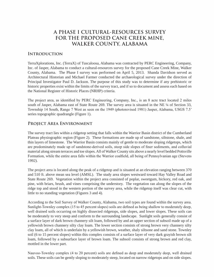
TerraXplorations, Inc. (TerraX) of Tuscaloosa, Alabama was contracted by PERC Engineering, Company, Inc. of Jasper, Alabama to conduct a cultural-resources survey for the proposed Cane Creek Mine, Walker County, Alabama. The Phase I survey was performed on April 5, 2013. Shanda Davidson served as Architectural Historian and Michael Farmer conducted the archaeological survey under the direction of Principal Investigator Paul D. Jackson. The purpose of this study was to determine if any prehistoric or historic properties exist within the limits of the survey tract, and if so to document and assess each based on the National Register of Historic Places (NRHP) criteria.
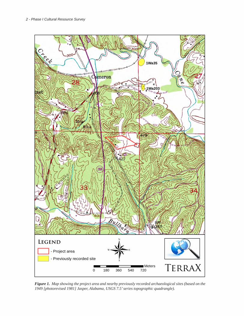
The project area, as identified by PERC Engineering, Company, Inc., is an 8 acre tract located 2 miles south of Jasper, Alabama east of State Route 269. The survey area is situated in the NE ¼ of Section 33, Township 14 South, Range 7 West as seen on the 1949 (photorevised 1981) Jasper, Alabama, USGS 7.5’ series topographic quadrangle (Figure 1).
Project Area Environment
The survey tract lies within a ridgetop setting that falls within the Warrior Basin district of the Cumberland Plateau physiographic region (Figure 2). These formations are made up of sandstone, siltstone, shale, and thin layers of limestone. The Warrior Basin consists mainly of gentle to moderate sloping ridgetops, which are predominately made up of sandstone-derived soils, steep side slopes of finer sediments, and colluvial material along stream terraces and toe slopes. All of Walker County sits above a nearly level bedded Pottsville Formation, while the entire area falls within the Warrior coalfield, all being of Pennsylvanian age (Stevens 1992).
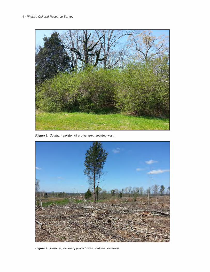
The project area is located along the peak of a ridgetop and is situated at an elevation ranging between 370 and 510 ft. above mean sea level (AMSL). The study area slopes westward toward Hay Valley Road and State Route 269. Vegetation within the project area consisted of poplar, sweetgum, hickory, red oak, and pine, with briars, brush, and vines comprising the understory. The vegetation ran along the slopes of the ridge top and stood in the western portion of the survey area, while the ridgetop itself was clear cut, with little to no standing vegetation (Figures 3 and 4).
According to the Soil Survey of Walker County, Alabama, two soil types are found within the survey area. Sunlight-Townley complex (15 to 45 percent slopes) soils are defined as being shallow to moderately deep, well drained soils occurring on highly dissected ridgetops, side slopes, and lower slopes. These soils can be moderately to very steep and conform to the surrounding landscape. Sunlight soils generally consist of a surface layer of dark brown channery silt loam, followed by and an upper section of subsoil made up of a yellowish brown channery silty clay loam. The lower section consists of strong brown very channery silty clay loam, all of which is underlain by a yellowish brown, weather, shaly siltsone and sand stone. Townley soil (6 to 15 percent slopes) within this complex consists of a surface layer of very dark grayish brown silt loam, followed by a subsurface layer of brown loam. The subsoil consists of strong brown and red clay, mottled in the lower part.
Nauvoo-Townley complex (4 to 20 percent) soils are defined as deep and moderately deep, well drained soils. These soils can be gently sloping to moderately steep, located on narrow ridgetops and on side slopes.
2 - Phase I Cultural Resource Survey
Figure 1. Map showing the project area and nearby previously recorded archaeological sites (based on the 1949 [photorevised 1981] Jasper, Alabama, USGS 7.5’ series topographic quadrangle).
1Wa203
1Wa35
®0 180 360 540 720
Meters TerraX
Legend
- Project area
- Previously recorded site

- 3TerraXplorations
Figure 2. Physiographic Regions Map of Alabama (The University of Alabama 2013).
4 - Phase I Cultural Resource Survey
Figure 4. Eastern portion of project area, looking northwest.
Figure 3. Southern portion of project area, looking west.
- 5TerraXplorations
Nauvoo soil is generally found on the higher, less sloping ridgetops and upper side slopes, with Townley soils being found on the lower ridges and side slopes. Nauvoo soil has a surface layer of dark yellowish brown fine sandy loam. The upper part of the subsoil consists of a red and yellowish red clay loam and sandy clay loam, while the lower part consists of a mottled yellowish red and strong brown fine sandy loam.
Literature and Document Search
Before conducting the fieldwork, TerraX performed a literature and document search in order to gather pertinent background information regarding the subject property and its surroundings. This research included inspections of the Alabama State Archaeological Site File (ASASF) (Office of Archaeological Research [OAR] 2013), the Alabama Register of Landmarks and Heritage (ARLH) (Alabama Historical Commission 2013), and the National Register of Historic Places (NRHP) (National Park Service 2013).
Research of the ASASF (OAR 2013) identified two previously recorded sites (1Wa35 and 1Wa203) located within a mile of the survey tract. Site 1Wa35 was recorded by Jacksonville State University in 1989. This site is described as an unknown aboriginal lithic scatter. Site 1Wa35 was deemed ineligible for the NRHP. Site 1Wa203 was recorded by C.E. Hill of Jacksonville State University while performing a survey for the nearby Hay Valley Mine (Holstein and Hill 1999). This Woodland and Mississippian village site produced various prehistoric ceramics and lithics and is considered potentially eligible for the NRHP.
Research of the Alabama Register of Landmarks and Heritage (Alabama Historical Commission 2013) and the NRHP (National Park Service 2013) failed to identify any historic properties within or near the project area.
Field Methods
The Phase I survey was guided by procedural standards created by the Alabama Council of Professional Archaeologists in concurrence with the Alabama Historical Commission’s (2002) specifications as outlined in the Policy for Archaeological Surveying and Testing in Alabama. Land coverage requirements were achieved by walking and visually inspecting the entire survey area. Any exposed surfaces were carefully examined for cultural material. For areas determined to have a low probability of containing archaeological deposits (such as graded areas with exposed subsoil, areas of push piles, and low wet drainages) pedestrian walkover was the primary method of survey. For medium to high probability areas, systematic subsurface testing is generally employed.
Typically, subsurface testing is performed judgmentally or along 30-m interval transects comprised of shovel tests spaced 30 m apart. Standard shovel tests consist of 30 centimeter (cm) diameter cylindrical holes excavated to the top of the sterile subsoil layer. Soils from each test are screened through 1/4-inch hardware cloth for the purpose of recovering any cultural material that may exist at that location. When cultural material is encountered, the material is sorted by provenience and placed into bags labeled with the pertinent excavation information before being transported to TerraX’s laboratory.
Laboratory Methods and Collection Curation
All cultural materials recovered during field projects are delivered to TerraX’s laboratory in Tuscaloosa, Alabama for processing. Here, materials are sorted by provenience, cleaned, and analyzed. Along with the cultural material, all project records, photographs, and maps produced while conducting the investigation are transported for curation at the Office of Archaeological Research, Erskine Ramsey Curation Facility, University of Alabama Museums, Moundville, Alabama.
6 - Phase I Cultural Resource Survey
Results of Field Investigation
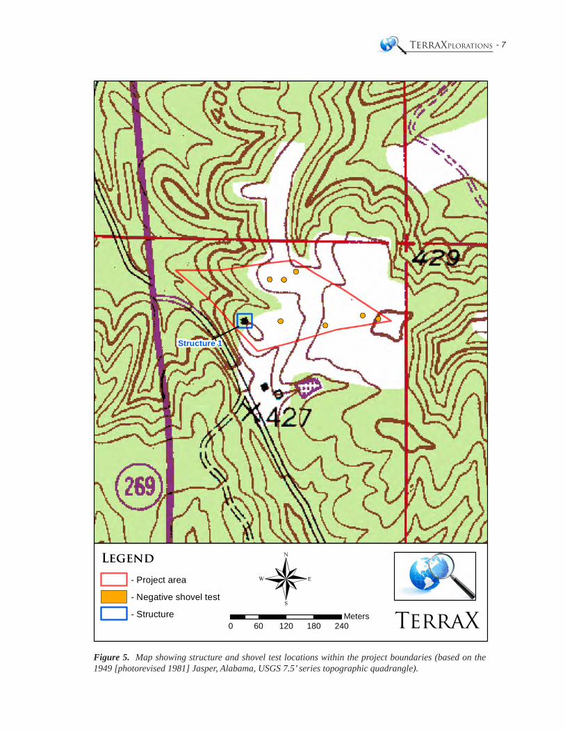
The 8 acre survey parcel is located 2 miles south of Jasper, Alabama just east of the State Route 269 and Hay Valley Road intersection. The current survey area sits atop an undulating ridge top, surrounded by sloped sides. The Hay Valley Mine abuts the project area to the north. A logging road (Haul Road) demarcates this boundary. The eastern corner of the survey area represents the highest point in the survey tract, while the western boundary is found at the end of a small, steep, deep, drainage. Two small hunting blinds are located in the central portion of the survey tract overlooking a small grassy area. Approximately 70% of the survey has been clear-cut, with vegetation remaining on the side slopes and within the western portion of the survey area.
The investigation included both subsurface and surface inspections of the subject property. A total of seven judgmental shovel tests were placed in areas of least disturbance on what appeared to be higher, terraced areas, atop slopes and drainages (Figure 5). All seven tests produced negative results exposing shallow soils. Shovel test profiles consisted of 3 to 15 cm of yellowish brown silt loam above a strong brown to reddish brown silty clay subsoil. Eroded sandstone and shale were encountered in each shovel test. Visual examinations failed to identify any cultural material on exposed surfaces.
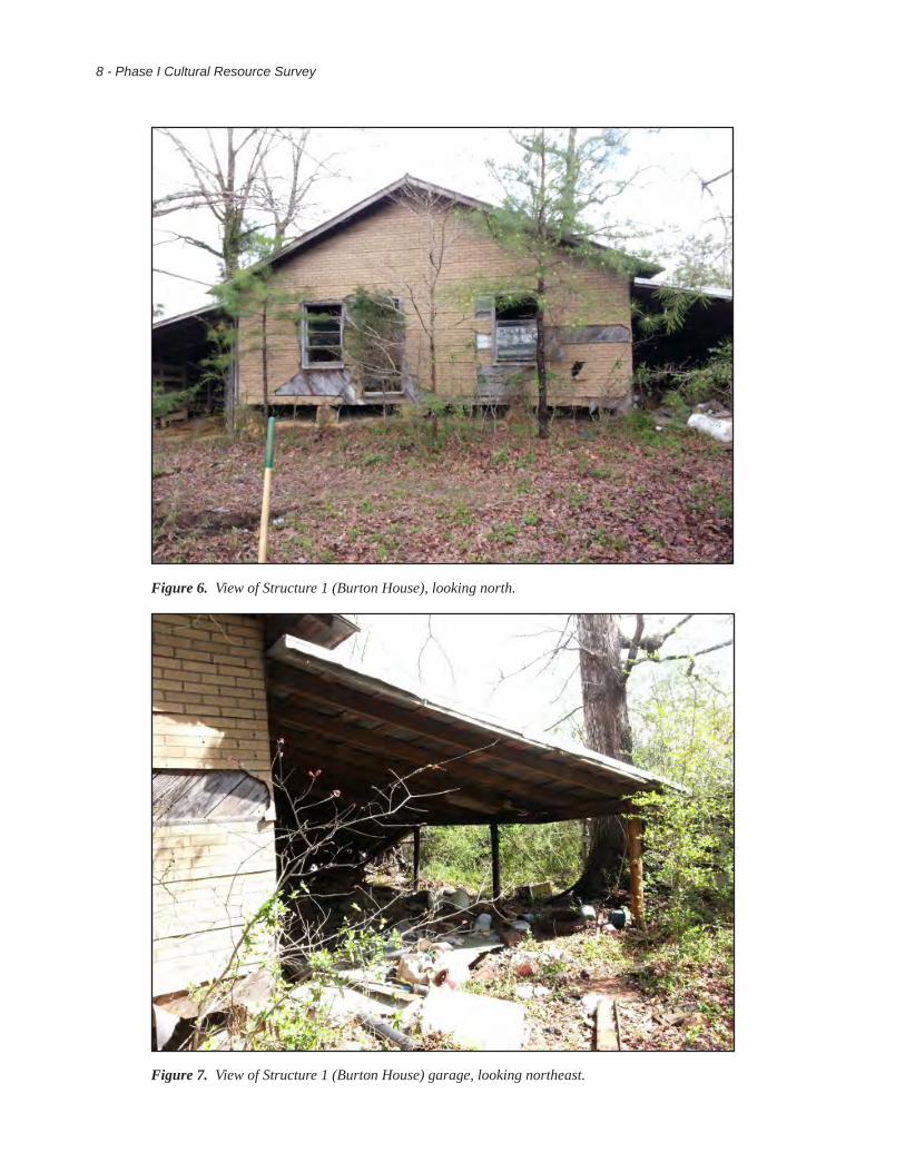
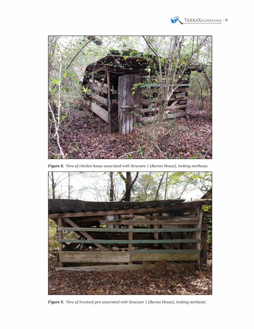
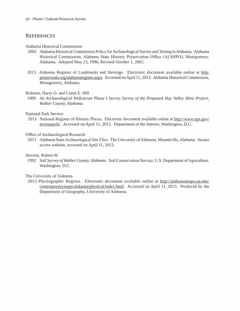
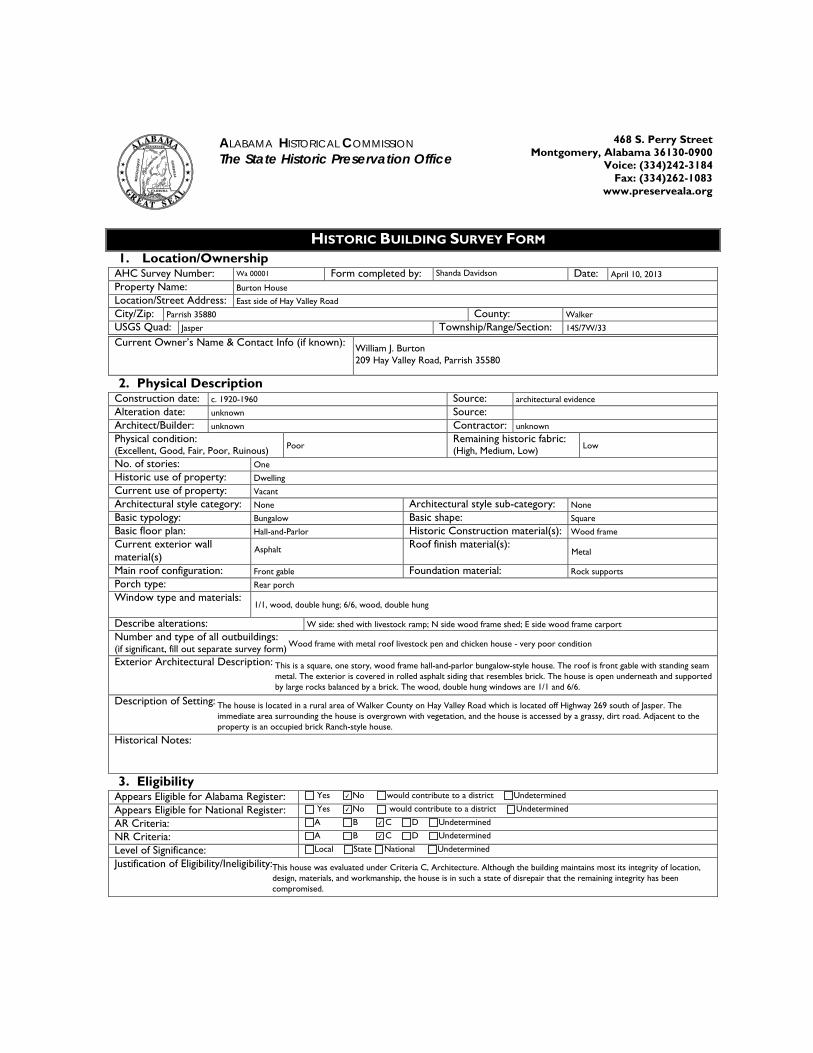
Although no archaeological sites were discovered, a structure was identified and recorded during the course of this survey. Structure 1 (Burton House) is of wood frame construction built between 1920 and 1960, based on the style of the house and exterior materials (Figures 6 and 7) (Appendix B). Additionally, this structure is seen on the 1949 (photorevised 1981) Jasper, Alabama 7.5’ topographic quadrangle (see Figure 5). This building is a wood frame bungalow style house with a front-gable roof of standing seam metal. Asphalt siding resembling bricks covers the exterior, covering a vertical plank outside wall. Stacked stone foundation pillars, evenly placed around the outside wall, support the structure. The north, east, and west side of the structure is surrounded by a wood post and standing seam metal roof utilitarian sheds. The east side contains a garage attached to the back porch. The west side of the structure contains a livestock ramp, which leads to the covered area on the north side of the structure, which has completely collapsed due to a falling tree. Two outbuildings are also associated with the structure; a wood frame chicken house located on the east side of the structure, and a wood frame livestock pen located off the northwest corner (Figures 8 and 9). After consideration under Criteria C, and applying seven aspects of integrity, it is determined that the Burton House is not eligible for the Alabama Register or the National Register. Although the house retains some its integrity of location, design, materials, and workmanship, the house is in such a state of disrepair that the remaining integrity has been compromised. Therefore, the determination of effects is no historic properties affected.
Conclusions and Recommendations
TerraX, under contract with PERC Engineering, Company, Inc., performed the Phase I cultural-resource survey for the proposed Cane Creek Mine, Walker County, Alabama in compliance with federal and state regulations. The project was conducted on April 5, 2013 by Michael Farmer and Shanda Davidson. The investigation resulted in the recording and evaluation of one historic structure within the project boundaries. Structure 1 (The Burton House) and it’s associated outbuildings are recommended as ineligible for listing in the Alabama and National Registers due to their lack of historic integrity. Based on the findings of this Phase I survey, no further archaeological studies are recommended for the subject property.
____________________ __________________ _________________ Michael Farmer Shanda Davidson Paul D. JacksonStaff Archaeologist Architectural Historian Principal Investigator
- 7TerraXplorations
Structure 1
®0 60 120 180 240
Meters TerraX
Legend
- Project area
- Negative shovel test
- Structure
Figure 5. Map showing structure and shovel test locations within the project boundaries (based on the 1949 [photorevised 1981] Jasper, Alabama, USGS 7.5’ series topographic quadrangle).
8 - Phase I Cultural Resource Survey
Figure 6. View of Structure 1 (Burton House), looking north.
Figure 7. View of Structure 1 (Burton House) garage, looking northeast.
- 9TerraXplorations
Figure 8. View of chicken house associated with Structure 1 (Burton House), looking northeast.
Figure 9. View of livestock pen associated with Structure 1 (Burton House), looking northeast.
10 - Phase I Cultural Resource Survey
References
Alabama Historical Commission2002 Alabama Historical Commission Policy for Archaeological Survey and Testing in Alabama. Alabama
Historical Commission, Alabama State Historic Preservation Office (ALSHPO), Montgomery, Alabama. Adopted May 13, 1996, Revised October 1, 2002.
2013 Alabama Register of Landmarks and Heritage. Electronic document available online at http: preserveala.org/alabamaregister.aspx. Accessed on April 11, 2013. Alabama Historical Commission, Montgomery, Alabama.
Holstein, Harry O. and Curtis E. Hill1999 An Archaeological Pedestrian Phase I Survey Survey of the Proposed Hay Valley Mine Project,
Walker County, Alabama.
National Park Service2013 National Register of Historic Places. Electronic document available online at http://www.nps.gov/
nr/research/. Accessed on April 11, 2013. Department of the Interior, Washington, D.C.
Office of Archaeological Research 2013 Alabama State Archaeological Site Files. The University of Alabama, Moundville, Alabama. Secure
access website, accessed on April 11, 2013.
Stevens, Robert W. 1992 Soil Survey of Walker County, Alabama. Soil Conservation Service, U.S. Department of Agriculture,
Washington, D.C.
The University of Alabama2013 Physiographic Regions. Electronic document available online at http://alabamamaps.ua.edu/
contemporarymaps/alabama/physical/index.html. Accessed on April 11, 2013. Produced by the Department of Geography, University of Alabama.

- 13TerraXplorations
Appendix ACuration Agreement
- 15TerraXplorations
- 17TerraXplorations
Appendix BHistoric Building Survey Form
- 19TerraXplorations
ALABAMA HISTORICAL COMMISSION The State Historic Preservation Office
468 S. Perry Street Montgomery, Alabama 36130-0900
Voice: (334)242-3184 Fax: (334)262-1083
www.preserveala.org
HISTORIC BUILDING SURVEY FORM 1. Location/Ownership
AHC Survey Number: Form completed by: Date: Property Name: Location/Street Address: City/Zip: County: USGS Quad: Township/Range/Section:
Current Owner’s Name & Contact Info (if known):
2. Physical Description Construction date: Source: Alteration date: Source: Architect/Builder: Contractor: Physical condition: (Excellent, Good, Fair, Poor, Ruinous)
Remaining historic fabric: (High, Medium, Low)
No. of stories: Historic use of property: Current use of property: Architectural style category: Architectural style sub-category: Basic typology: Basic shape: Basic floor plan: Historic Construction material(s): Current exterior wall material(s)
Roof finish material(s):
Main roof configuration: Foundation material: Porch type: Window type and materials:
Describe alterations: Number and type of all outbuildings: (if significant, fill out separate survey form) Exterior Architectural Description: Description of Setting: Historical Notes:
3. Eligibility Appears Eligible for Alabama Register: Yes No would contribute to a district Undetermined
Appears Eligible for National Register: Yes No would contribute to a district Undetermined
AR Criteria: A B C D Undetermined
NR Criteria: A B C D Undetermined
Level of Significance: Local State National Undetermined
Justification of Eligibility/Ineligibility:
Wa 00001 Shanda Davidson April 10, 2013
Burton House
East side of Hay Valley Road
Parrish 35880 Walker
Jasper 14S/7W/33
William J. Burton 209 Hay Valley Road, Parrish 35580
c. 1920-1960 architectural evidence
unknown
unknown unknown
Poor Low
One
Dwelling
Vacant
None None
Bungalow Square
Hall-and-Parlor Wood frame
Asphalt Metal
Front gable Rock supports
Rear porch
1/1, wood, double hung; 6/6, wood, double hung
W side: shed with livestock ramp; N side wood frame shed; E side wood frame carport
Wood frame with metal roof livestock pen and chicken house - very poor condition
This is a square, one story, wood frame hall-and-parlor bungalow-style house. The roof is front gable with standing seam metal. The exterior is covered in rolled asphalt siding that resembles brick. The house is open underneath and supported by large rocks balanced by a brick. The wood, double hung windows are 1/1 and 6/6.
The house is located in a rural area of Walker County on Hay Valley Road which is located off Highway 269 south of Jasper. The immediate area surrounding the house is overgrown with vegetation, and the house is accessed by a grassy, dirt road. Adjacent to the property is an occupied brick Ranch-style house.
✔
✔
✔
✔
This house was evaluated under Criteria C, Architecture. Although the building maintains most its integrity of location, design, materials, and workmanship, the house is in such a state of disrepair that the remaining integrity has been compromised.