abi instruments
TRANSCRIPT

WORLD’S CHOICE FOR GEO IMAGING
Advanced Baseline Imager (ABI)

MARKET-LEADING EXPERTISE DELIVERS BEST-IN-CLASS WEATHER IMAGING
WHAT IS ABI?Think of ABI as a digital camera built to capture contiguous images of the earth. Some cameras have both visible sensors to take pictures during the day and specialized thermal sensors to take pictures at night. ABI expands upon this concept, using an imaging reflectometer/ radiometer that effectively has 16 sensing channels spanning visible, near-infrared and infrared wavelengths (0.45 µm – 13.6 µm). Resolution ranges from 0.5 km (Visible) to 2 km (Infrared).
HOW DOES ABI HELP? Each ABI channel delivers data with unique characteristics. This data is analyzed to deliver information such as:
> Surface characteristics (vegetation, ice cover)
> Atmospheric conditions (wind, humidity, ozone)
> Cloud cover and type distinction (snow vs. smoke vs. ash)
This data is then fed into models, tools and plans to improve the accuracy of weather forecasts, advance the ability to detect and monitor fires and accurately assess vegetative health. It is also used to monitor and understand air pollution and volcanic ash.
In cases of extreme weather such as hurricanes, typhoons, blizzards and tornadoes, consequences can be devastating to land, property and peoples’ safety. Yet weather directly and indirectly affects everyday life as well; key challenges include:
> Weather forecasters need accurate data to predict upcoming weather impacts
> Fire departments need to characterize hot spots over large spans to effectively control large fires
> Environmental agencies need to analyze air quality to ensure safe living environments
> Aviators need to know where and when volcanic activity makes it unsafe to fly
> Agriculture organizations need to understand vegetative health to fertilize at the right times and optimize crop yield
Harris has leveraged over 40 years of weather imaging expertise to repeatedly deliver market-leading capability to both domestic and international markets to address these needs with Advanced Baseline Imager (ABI).
CloudParticle
Size
3.8
Ozone
Air Temp Cloud
Heights
13.6 .45 2.3
Daytime Clouds & Fog Vegetation Fire Humidity Temperature
Winds Snow Greenhouse Gases
Night Clouds & Fog
Winds & Ozone
Ash
Ice
(in µm)
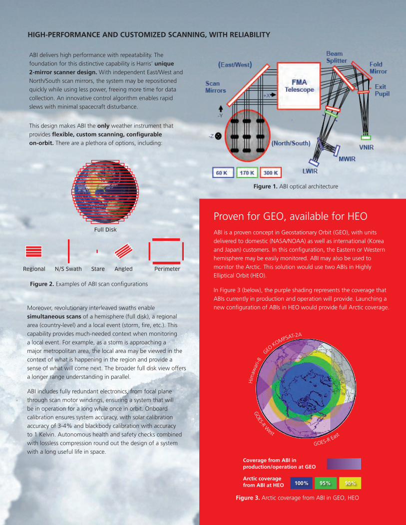
ABI delivers high performance with repeatability. The foundation for this distinctive capability is Harris’ unique 2-mirror scanner design. With independent East/West and North/South scan mirrors, the system may be repositioned quickly while using less power, freeing more time for data collection. An innovative control algorithm enables rapid slews with minimal spacecraft disturbance.
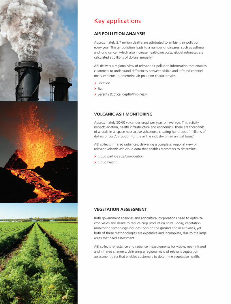
Proven for GEO, available for HEOABI is a proven concept in Geostationary Orbit (GEO), with units delivered to domestic (NASA/NOAA) as well as international (Korea and Japan) customers. In this configuration, the Eastern or Western hemisphere may be easily monitored. ABI may also be used to monitor the Arctic. This solution would use two ABIs in Highly Elliptical Orbit (HEO).
In Figure 3 (below), the purple shading represents the coverage that ABIs currently in production and operation will provide. Launching a new configuration of ABIs in HEO would provide full Arctic coverage.
HIGH-PERFORMANCE AND CUSTOMIZED SCANNING, WITH RELIABILITY
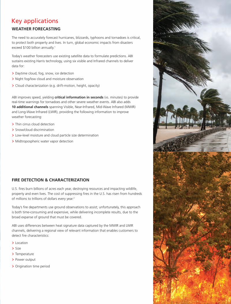
Figure 2. Examples of ABI scan configurations
Figure 1. ABI optical architecture
Moreover, revolutionary interleaved swaths enable simultaneous scans of a hemisphere (full disk), a regional area (country-level) and a local event (storm, fire, etc.). This capability provides much-needed context when monitoring a local event. For example, as a storm is approaching a major metropolitan area, the local area may be viewed in the context of what is happening in the region and provide a sense of what will come next. The broader full disk view offers a longer range understanding in parallel.
ABI includes fully redundant electronics, from focal plane through scan motor windings, ensuring a system that will be in operation for a long while once in orbit. Onboard calibration ensures system accuracy, with solar calibration accuracy of 3-4% and blackbody calibration with accuracy to 1 Kelvin. Autonomous health and safety checks combined with lossless compression round out the design of a system with a long useful life in space.
This design makes ABI the only weather instrument that provides flexible, custom scanning, configurable on-orbit. There are a plethora of options, including:
Full Disk
Regional N/S Swath Stare Angled Perimeter
Figure 3. Arctic coverage from ABI in GEO, HEO
Him
awar
i-8
G
EO KOMPSAT-2A
100% 95% 90%Arctic coverage from ABI at HEO
Coverage from ABI in production/operation at GEO
GO
ES-R West
GOES-R East
WEATHER FORECASTING
The need to accurately forecast hurricanes, blizzards, typhoons and tornadoes is critical, to protect both property and lives. In turn, global economic impacts from disasters exceed $100 billion annually.1
Today’s weather forecasters use existing satellite data to formulate predictions. ABI sustains existing Harris technology, using six visible and Infrared channels to deliver data for:
> Daytime cloud, fog, snow, ice detection
> Night fog/low cloud and moisture observation
> Cloud characterization (e.g. drift-motion, height, opacity)
ABI improves speed, yielding critical information in seconds (vs. minutes) to provide real-time warnings for tornadoes and other severe weather events. ABI also adds 10 additional channels spanning Visible, Near-Infrared, Mid-Wave Infrared (MWIR) and Long-Wave Infrared (LWIR), providing the following information to improve weather forecasting:
> Thin cirrus cloud detection
> Snow/cloud discrimination
> Low-level moisture and cloud particle size determination
> Midtropospheric water vapor detection
FIRE DETECTION & CHARACTERIZATION
U.S. fires burn billions of acres each year, destroying resources and impacting wildlife, property and even lives. The cost of suppressing fires in the U.S. has risen from hundreds of millions to trillions of dollars every year.2
Today’s fire departments use ground observations to assist; unfortunately, this approach is both time-consuming and expensive, while delivering incomplete results, due to the broad expanse of ground that must be covered.
ABI uses differences between heat signature data captured by the MWIR and LWIR channels, delivering a regional view of relevant information that enables customers to detect fire characteristics:
> Location
> Size
> Temperature
> Power output
> Origination time period
Key applications
AIR POLLUTION ANALYSIS
Approximately 3.7 million deaths are attributed to ambient air pollution every year. This air pollution leads to a number of diseases, such as asthma and lung cancer, which also increase healthcare costs; global estimates are calculated at billions of dollars annually.3
ABI delivers a regional view of relevant air pollution information that enables customers to understand differences between visible and infrared channel measurements to determine air pollution characteristics:
> Location
> Size
> Severity (Optical depth/thickness)
VOLCANIC ASH MONITORING
Approximately 50-60 volcanoes erupt per year, on average. This activity impacts aviation, health infrastructure and economics. There are thousands of aircraft in airspace near active volcanoes, creating hundreds of millions of dollars of cost/disruption for the airline industry on an annual basis.4
ABI collects infrared radiances, delivering a complete, regional view of relevant volcanic ash cloud data that enables customers to determine:
> Cloud particle size/composition
> Cloud height
VEGETATION ASSESSMENT
Both government agencies and agricultural corporations need to optimize crop yields and desire to reduce crop production costs. Today, vegetation monitoring technology includes tools on the ground and in airplanes, yet both of these methodologies are expensive and incomplete, due to the large areas that need assessment.
ABI collects reflectance and radiance measurements for visible, near-infrared and infrared channels, delivering a regional view of relevant vegetation assessment data that enables customers to determine vegetative health.
Key applications
Sources:1. Global Assessment Report on Disaster Risk Reduction, 2013.2. National Interagency Fire Center (http://www.nifc.gov/fireInfo/fireInfo_documents/SuppCosts.pdf)3. World Health Organization (http://www.who.int/phe/health_topics/outdoorair/databases/AAP_BoD_results_March2014.pdf)4. Volcano Live (http://www.volcanolive.com/vei.html)
Key applications
Harris is a registered trademark of Harris Corporation.Trademarks and tradenames are the property of their respective companies.© 2015 Harris Corporation 0043 07/15
Non-Export-Controlled Information
Harris is dedicated to developing best-in-class assured communications® products, systems and services.