aas 16-464 lunar advanced radar orbiter for subsurface ... · pdf filelunar advanced radar...
TRANSCRIPT
AAS 16-464
LUNAR ADVANCED RADAR ORBITER FOR SUBSURFACESOUNDING (LAROSS): LAVA TUBE EXPLORATION MISSION
Rohan Sood∗, H. Jay Melosh†, and Kathleen Howell‡
With the goal of expanding human presence beyond Earth, sub-surfaceempty lava tubes on other worlds form ideal candidates for creating apermanent habitation environment safe from cosmic radiation, microm-eteorite impacts and temperature extremes. In a step towards Mars ex-ploration, the Moon offers the most favorable pathway for lava tube ex-ploration. In-depth analysis of GRAIL gravity data has revealed severalcandidate empty lava tubes within the lunar maria. The goal of this in-vestigation is a proposed subsurface radar sounding mission to explore theregions of interest and potentially confirm the presence and size of buriedempty lava tubes under the lunar surface.
INTRODUCTION
NASA’s successful Gravity Recovery and Interior Laboratory (GRAIL) has determined
the lunar gravity field to an unprecedented precision.1 Through gravitational analysis of
the Moon, subsurface features, including potential buried empty lava tubes, have been de-
tected.2 Lava tubes create an interest as possible human habitation sites safe from cosmic
radiation, micrometeorite impacts and temperature extremes. The existence of such natural
caverns is supported by Kaguya’s discoveries of deep pits that may potentially be openings
to empty lava tubes.3 The goal of this investigation is a proposed sub-surface radar sound-
ing mission to potentially confirm the presence and size of buried empty lava tubes under
the lunar surface. The high resolution gravity field derived from the GRAIL data will allow
a spacecraft to accurately navigate at altitudes of 10 to 20 km over the mare regions. The
radar sounder system is designed to penetrate the lunar surface from a few meters to a few
kilometers in search of signatures that can confirm the presence, depth and extent of an
empty lava tube. The results will be compared to the findings from GRAIL gravity analysis
and the locations of known lunar skylights. Once detection is confirmed, such sites can be
assessed for future human habitation and exploration on the Moon, Mars, and beyond.
∗Ph.D. Candidate, School of Aeronautics and Astronautics, Purdue University, 701 West Stadium Avenue,
West Lafayette, IN 47907-2045, USA. 765-409-2871, [email protected]†Distinguished Professor EAS/Physics, Department of Earth, Atmospheric and Planetary Sciences, Pur-
due University, 550 Stadium Mall Drive, West Lafayette, Indiana 47907-2051, USA. 765-494-3290,
[email protected]‡Hsu Lo Distinguished Professor of Aeronautics and Astronautics, School of Aeronautics and Astronautics,
Purdue University, 701 West Stadium Avenue, West Lafayette, IN 47907-2045, USA. 765-494-5786, how-
1
SCIENTIFIC INTEREST
With the goal of expanding human presence beyond Earth, buried empty lava tubes on
other worlds form ideal candidates for creating a permanent habitation environment. The
lunar surface, unprotected by an atmosphere, is vulnerable to both direct and secondary me-
teoroid impacts and is exposed to cosmic and solar particle radiation that pose severe chal-
lenges to a lunar base on the surface.4 With multiple layers of lava basalt forming a meters-
thick roof, buried empty lava tubes can supply a safe zone away from life-threatening condi-
tions. The ambient temperature in a lava tube is nearly constant, in contrast to the extremes
on the lunar surface.5 In addition to the protection afforded by buried lunar lava tubes,
siting habitats in such caverns can lower the cost associated with setting up a habitat on the
lunar surface sufficiently safe for humans with the aim of providing a stable environment
for long-term/permanent lunar habitation.4 Lunar lava tubes also offer a pristine environ-
ment to examine a part of the Moon untouched by the extremities and impurities introduced
by micrometeorites to which the lunar surface is continuously exposed. Such an environ-
ment can also add insight concerning the lunar history and facilitate careful examination of
its composition.
Potential buried lava tubes and skylights have also been detected on Mars.6, 7 Possible
lava tube structures were first recognized in the images from the Viking orbiter. Subse-
quent observation and identification were obtained by Mars Odyssey, Mars Global Sur-
veyor, Mars Express and Mars Reconnaissance Orbiter.8–10 Prior to a journey to Mars with
the goal of colonizing the planet, it is vital to analyze the potential of exploiting lava tubes
as habitation sites. Although Mars does possess an atmosphere, it is extremely thin, the
surface is exposed to cosmic radiation, undergoes huge temperature swings, and experi-
ences occasional storms that often extend across most of the planet.11, 12 Such conditions
can be devastating and prove fatal on the Martian surface. To prevent exposure to such
life-threatening events, and to reduce the cost of setting up human habitats on the surface
of the Mars, it is beneficial to explore Martian lava tubes as potential sites for future human
habitats. Thus, in a step towards Mars exploration, the Moon offers the most favorable
pathway for lava tube exploration as future human habitats beyond the Earth.
In addition to the benefit of safe habitation sites on both the Moon and the Mars, buried
lava tubes, with potential access through a skylight, can also allow harvesting underground
mineral resources.13 Subsurface caverns can be explored and natural resources exploited
without excavation. Given that these sites grant ambient temperatures, in contrast to those
on the surface, some researchers suggest that, if life does exist on Mars, it is likely to be
detected in the habitable environment of subsurface empty lava tubes.14, 15 Essential life-
supporting volatiles, such as water, could potentially be trapped in these subsurface caverns
creating a more hospitable life-supporting environment. Thus, exploration of lava tubes on
Mars is a significant goal for the scientific community as an opportunity to explore the
Martian subsurface history and astrobiological past.
2
MISSION GOALS
In-depth analysis of GRAIL gravity data has revealed several candidate empty lava tubes
within the lunar maria. The goal of the proposed mission is a subsurface radar sounder
in orbit around the Moon to further explore the regions of interest and potentially validate
the existence of candidate lava tubes. Additional lava tube candidates may be detected,
particularly those beyond the resolution of the GRAIL gravity data. The radar sounder
system will map the entire mare from a few meters to few kilometers below the lunar
surface. Positive confirmation of buried empty lava tubes on the Moon, with possible
access as habitation sites, would offer scientists, engineers, and astronauts an opportunity
to examine the environment and satisfy crucial exploration goals identified in the roadmap
to Mars.16 The data from the envisioned subsurface sounder might also support science
inquiries, such as the nature of the enigmatic mare ridges, the location of the feeder dikes
for lava eruptions, as well as the depth and extent of impact melt in large lunar craters.
Examining the structure of lunar volcanic vents, where the Moon’s internal heat resulted
in massive volcanic eruptions, is also gaining interest.17 A large number of features re-
sembling vents similar to shield volcanoes have been detected within the 2,500 km wide
Oceanus Procellarum, particularly on and around the Aristarchus plateau.18 GRAIL data
analysis suggests that Procellarum may be flooded by large volcanic eruptions caused by
Moon’s internal heat. The proposed feeder dikes for these lavas lie in a large system that
follows the outline of Oceanus Procellarum.19 Within Oceanus Procellarum lies the very
distinct Aristarchus plateau comprised of both low and high reflectance terrain units.20 The
plateau is surrounded by lava flows and the region itself is covered by a large number of
sinuous rilles, characterized by meandering channels of varying widths and depths. The
rilles are often associated with the presence of depressions of various morphology that are
interpreted as potential source vents for the lava flow that initially formed the lavas that
flowed through the channels.21 One of the largest lunar rilles, Vallis Schroteri lies within
the Aristarchus plateau. This rille originates from a feature that resembles a ‘cobra head’
that consists of a deep pit and is thought to be the source of a massive lava outflow that
meandered across the Aristarchus plateau and formed Vallis Schroteri.22 The rille ends
abruptly with no surface expression. GRAIL data analysis has demonstrated a potentially
uncollapsed buried lava tube that extends beyond the visible surface expression.2 The radar
mission can assist in understanding and deciphering the mystery beneath structures of vol-
canic vents as well as explore specific target areas along with a general survey in search for
buried empty lava tubes.
PREVIOUS GROUND PENETRATING RADAR MISSIONS
Ground penetrating radar serves to meet a variety of multidisciplinary scientific goals.
With transmitted radio waves, ground penetrating radar can probe deep into the subsurface
and reflect electromagnetic waves off layers and structures of varying dielectric constant.
The returned waves are received and processed to map the subsurface of the body of inter-
est.
3
Apollo Lunar Sounder Experiment (ALSE):
In 1972, a ground penetrating radar via the Apollo Lunar Sounder Experiment, was flown
on NASA’s Apollo 17 mission. Radar waves at three different frequencies were transmit-
ted to examine the lunar surface and interior. As with any radar-based mission, the choice
of frequencies (5, 15, and 150 MHz) was critical in decision-making to produce a bal-
ance between the desired resolution and the penetration depth. Longer wavelengths (lower
frequencies) penetrate deeper below the surface, whereas shorter wavelengths (higher fre-
quencies) yield higher resolution to differentiate between the echoes.
The main objective of the ALSE was exploration of the upper 2 km of the lunar crust.
The lack of water on the Moon enabled deeper penetration using the longer wavelengths
than is possible on Earth. Shorter wavelengths assist in generating surface images and lu-
nar profiles. The data analysis led to precise topographic information and revealed several
structures under the lunar maria. The experiment yielded some initial estimates for the
thickness of the basaltic layers and lava flows.23 An improved, but not sufficient, under-
standing of the mare ridges (also known as wrinkle ridges) allowed geologists to speculate
on the formation of these long, low lunar ridges supporting the hypothesis that their forma-
tion was a result of motion along faults cutting through the mare lavas.
Mars Advanced Radar for Subsurface and Ionosphere Sounding (MARSIS):
On-board ESA’s Mars Express spacecraft, MARSIS is a low frequency radar sounder
designed to assess the Martian subsurface with the aim of locating frozen water. Deployed
in 2005, MARSIS enabled differentiation between the dielectric constant of the northern
and southern high-latitude regions.24 This radar operated in the 1–5 MHz frequency range.
The low frequency permitted the waves to penetrate deeper, up to depths of 5 km, allowing
exploration of Martian crustal properties, geological processes, subsurface ice and liquid
water. The data also suggested that the northern basin is filled with low density material
that can possibly be interpreted as evidence for an ancient northern ocean. Although the
radar has the advantage of penetrating deep below the Martian surface, MARSIS has a rel-
atively coarse resolution. The need to further explore the top few hundreds of meters below
the Martian surface prompted a need for an instrument to complement the results of MAR-
SIS by providing finer resolution of the top 10-20 meters to understand the sedimentary
processes and geologic activity.
Mars SHAllow RADar sounder (SHARAD):
The Italian Space Agengy’s SHAllow RADar on NASA’s Mars Reconnaissance Orbiter
(MRO) is a subsurface sounding radar that was launched in 2005. The experiment is de-
signed to investigate the Martian subsurface near the polar ice caps and carry out a global
survey in a search for underground ice and liquid water by examining the subsurface inter-
faces. SHARAD operates at a central frequency of 20 MHz with a 10 MHz bandwidth that
complements the findings from MARSIS and characterizes the upper km of the Martian
surface with greater resolution. The experiment also aims to estimate surface roughness at
scales 10–100 m to assess the physical properties, landing safety and site trafficability.25
4
Lunar Radar Sounder (LRS):
For subsurface observations of the lunar interior, the Lunar Radar Sounder experiment
flew onboard the Japanese Kaguya (SELENE) spacecraft in 2009. The instrument oper-
ated throughout most of the nominal mission during which low frequency (5 MHz) waves
were used to map and characterize the lunar subsurface under the maria.26 The LRS was
equipped with two sets of 30 m dipole antennas. The low frequency waves enabled map-
ping the subsurface to a depth of several km but the resolution was on the order of 100
m. The primary objective of the LRS mission was to investigate the thermal history of the
Moon and understand its evolution over a time scale of hundreds of millions of years. As a
result, the observations revealed stratification and tectonic features under the lunar surface
that may assist in understanding the thermal evolution of the Moon.
Ground Penetrating Radar (GPR):
In 2013, China’s Yutu rover on-board the Chang’e 3 spacecraft was the first to carry out
direct measurements of the Moon’s near-surface structures with a ground penetrating radar
attached to the underbelly of the Yutu rover. The radar operated at central frequencies of 60
and 500 MHz permitting a range resolution of 3.75 and 0.3 m, respectively.27, 28 The data
from the radar instrument suggested a 1 m thick reworked zone underlain by a 2-6 m thick
ejecta layer near the landing site within northern Mare Imbrium. The rover covered a total
distance of 114 meters over two lunar days. Due to mechanical issues associated with the
rover controls, no further area was traversed.
INSTRUMENT AND FRAMEWORK
Radar sounding from lunar orbit offers global coverage of the vast mare region. High
precision and accurate knowledge of the GRAIL gravity data permits the spacecraft to fly at
much lower altitudes than previous orbital missions over the regions of interest. Multiple,
low altitude revolutions over the same area can supply the large data sets that are essential
for unambiguous 3-D mapping of the lunar subsurface. To compliment the polar orbit
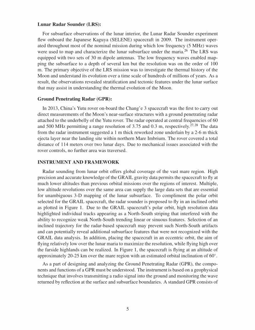
selected for the GRAIL spacecraft, the radar sounder is proposed to fly in an inclined orbit
as plotted in Figure 1. Due to the GRAIL spacecraft’s polar orbit, high resolution data
highlighted individual tracks appearing as a North-South striping that interfered with the
ability to recognize weak North-South trending linear or sinuous features. Selection of an
inclined trajectory for the radar-based spacecraft may prevent such North-South artifacts
and can potentially reveal additional subsurface features that were not recognized with the
GRAIL data analysis. In addition, placing the spacecraft in an eccentric orbit, the aim of
flying relatively low over the lunar maria to maximize the resolution, while flying high over
the farside highlands can be realized. In Figure 1, the spacecraft is flying at an altitude of
approximately 20-25 km over the mare region with an estimated orbital inclination of 60◦.
As a part of designing and analyzing the Ground Penetrating Radar (GPR), the compo-
nents and functions of a GPR must be understood. The instrument is based on a geophysical
technique that involves transmitting a radio signal into the ground and monitoring the wave
returned by reflection at the surface and subsurface boundaries. A standard GPR consists of
5
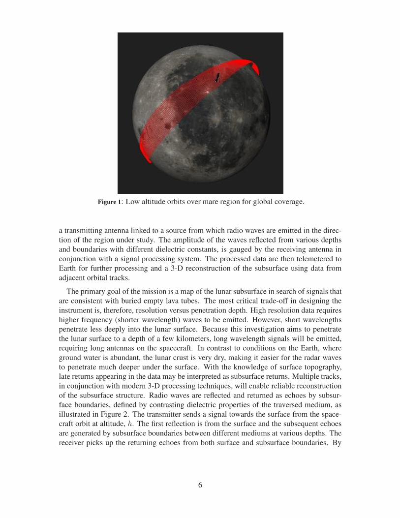
Figure 1: Low altitude orbits over mare region for global coverage.
a transmitting antenna linked to a source from which radio waves are emitted in the direc-
tion of the region under study. The amplitude of the waves reflected from various depths
and boundaries with different dielectric constants, is gauged by the receiving antenna in
conjunction with a signal processing system. The processed data are then telemetered to
Earth for further processing and a 3-D reconstruction of the subsurface using data from
adjacent orbital tracks.
The primary goal of the mission is a map of the lunar subsurface in search of signals that
are consistent with buried empty lava tubes. The most critical trade-off in designing the
instrument is, therefore, resolution versus penetration depth. High resolution data requires
higher frequency (shorter wavelength) waves to be emitted. However, short wavelengths
penetrate less deeply into the lunar surface. Because this investigation aims to penetrate
the lunar surface to a depth of a few kilometers, long wavelength signals will be emitted,
requiring long antennas on the spacecraft. In contrast to conditions on the Earth, where
ground water is abundant, the lunar crust is very dry, making it easier for the radar waves
to penetrate much deeper under the surface. With the knowledge of surface topography,
late returns appearing in the data may be interpreted as subsurface returns. Multiple tracks,
in conjunction with modern 3-D processing techniques, will enable reliable reconstruction
of the subsurface structure. Radio waves are reflected and returned as echoes by subsur-
face boundaries, defined by contrasting dielectric properties of the traversed medium, as
illustrated in Figure 2. The transmitter sends a signal towards the surface from the space-
craft orbit at altitude, h. The first reflection is from the surface and the subsequent echoes
are generated by subsurface boundaries between different mediums at various depths. The
receiver picks up the returning echoes from both surface and subsurface boundaries. By
6
Figure 2: Schematic for GPR transmitting and receiving wave signal from lunar orbit.
analyzing the echoes generated, delay times can be converted to the depths of subsequent
boundaries on a sample-by-sample basis using
∆di =1
2∆tcǫ
−1/2i (1)
where ∆di is the depth interval for the i−th sample, ∆t is the delay-time sampling interval,
c is the speed of light, and ǫi is the dielectric constant of the traversed medium.25 The factor
of 1/2 accommodates the two-way distance traveled by the wave.
The shortest possible pulse is not always ideal for achieving the desired range resolution.
Orbiting radars exploit a signal shaping strategy, called chirp, that employs a long pulsating
signal linearly modulated in frequency. The vertical resolution of the radar, ρz, is defined
as
ρz =c
2Bw√ǫi
(2)
where Bw is the bandwidth of the transmitted pulse.29 A similar signal shaping technique
was adopted by SHAlow RADar (SHARAD) subsurface sounding radar aboard the Mars
Reconnaissance Orbiter (MRO). The transmitter emits a 10 W, 85 µs chirped pulse cen-
tered at 20 MHz with 10 MHz bandwidth. The configuration yields vertical and horizontal
resolutions of ∼7 m and 0.3–1 km ∼ 3–7 km (along-track ∼ cross-track), respectively.
Though the frequency band resulted in higher resolution, the penetration depth was limited
7
to ∼1 km. To compliment SHARAD, the Mars Advanced Radar for Subsurface and Iono-
sphere Sounding (MARSIS) spacecraft operated at a frequency range of 1–5 MHz, capable
of penetrating up to 5 km under the surface of the MARS, but the instrument was limited by
range resolution.30 In 1972, the GPR experiment that flew aboard Apollo 17 was capable of
penetrating the lunar surface up to a depth of 1.3 km with 100 m range resolution operating
at frequencies of 5, 15 and 150 MHz.31 The penetration depths of the radar sounder aboard
JAXA’s 2007 SELenological and ENngineering Explorer (SELENE) was 5 km with 75 m
range resolution operating at 4–6 MHz.32 Thus, an appropriate balance between the data
resolution and penetration depth is desirable.
These previous missions demonstrate the feasibility of deep penetration of the lunar sur-
face with relatively low power transmitters. These missions have already produced data
about the dielectric constant for the lunar surface lavas (for both real and imaginary parts)
at a number of relevant frequencies. The proposed mission will exceed the performance of
these radars, however, mainly because of the low altitudes as a consequence of the high-
precision GRAIL gravity field that enables safe navigation at altitudes of 10 km or less,
a capability already demonstrated as part of the GRAIL Extended mission.33–35 Like all
radars, the returned signal strength is proportional to the inverse fourth power of the dis-
tance between the transmitter and receiver, so that decreasing altitude from the minimum
altitude of 50 km for Kaguya (or about 100 km for the Apollo 17 command module orbit)
down to 10 km yields an increase in signal strength by a factor of 625, which will greatly
enhance detection of discontinuities below the lunar surface.
PRELIMINARY RESULTS FROM GRAIL GRAVITY SURVEYS
General Survey
With high resolution topography and gravitational data available for the Moon, it is now
possible to recognize the gravitational footprints that may correspond to subsurface density
anomalies. Topography data from Lunar Orbiter Laser Altimeter (LOLA), for a vast region
of interest covering Oceanus Procellarum, appears in Figure 3a. Topography and surface
imagery do not allow detection of subsurface features such as empty lava tubes. Thus, the
GRAIL gravity data is exploited to detect the mass deficit associated with buried empty
lava tubes. A numerical strategy based on the gradiometry technique has been developed
to assist in the detection of subsurface features.2 The technique exploits gravity gradients
and the computation of eigenvalues and eigenvectors associated with the Hessian matrix
which consists of the second horizontal derivatives of the gravity potential. The Bouguer
gravity potential (equal to the observed potential minus that associated with topography) is
analyzed by developing eigenvalue maps that depict the magnitude and direction of gravity
at each point on the grid as apparent in Figure 3b. As a consequence of the second deriva-
tive in the computation of the Hessian, a negative anomaly (mass deficit) corresponds to a
positive eigenvalue on the map. Thus, the color scale in Figure 3b represents the signed
magnitude of the largest magnitude eigenvalue of the Hessian derived from the gravitational
potential. The maps are produced by averaging three different gravity models represent-
ing the same initial harmonic data with different lower and upper wavelength truncations to
8
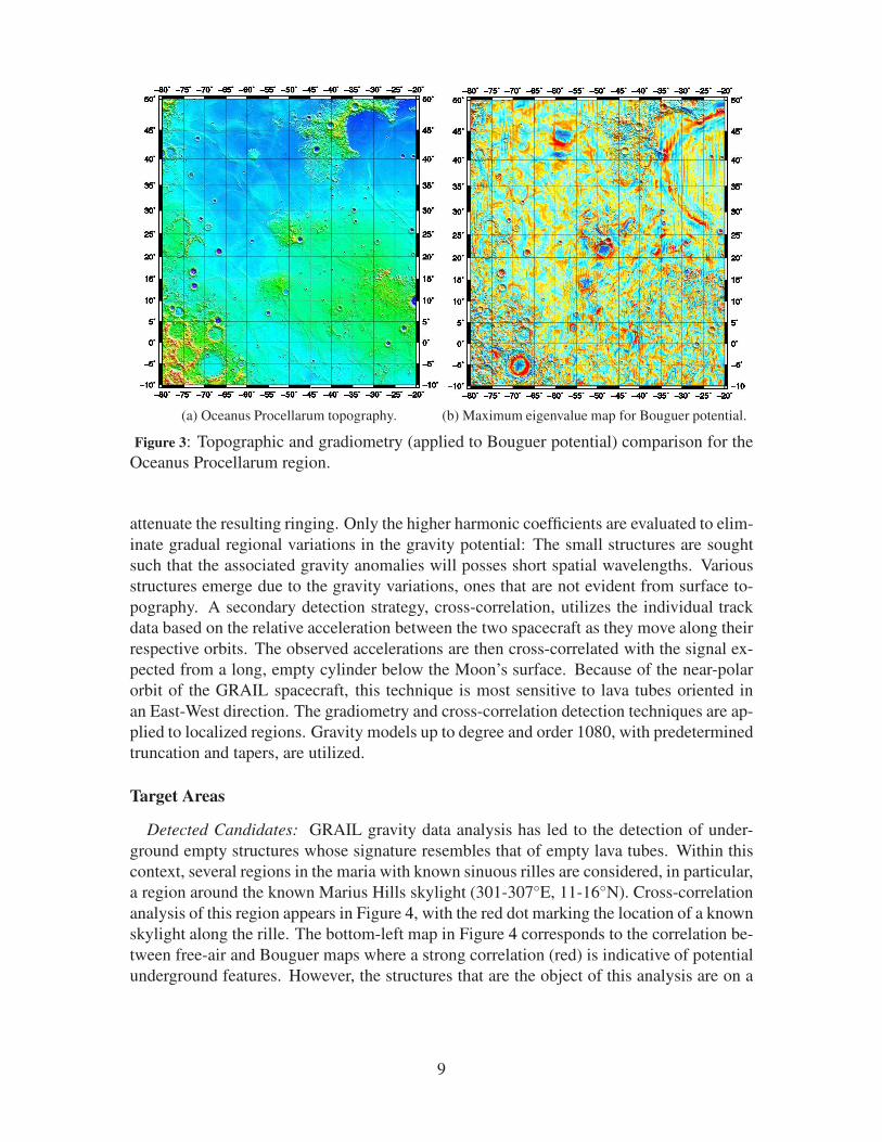
(a) Oceanus Procellarum topography. (b) Maximum eigenvalue map for Bouguer potential.
Figure 3: Topographic and gradiometry (applied to Bouguer potential) comparison for the
Oceanus Procellarum region.
attenuate the resulting ringing. Only the higher harmonic coefficients are evaluated to elim-
inate gradual regional variations in the gravity potential: The small structures are sought
such that the associated gravity anomalies will posses short spatial wavelengths. Various
structures emerge due to the gravity variations, ones that are not evident from surface to-
pography. A secondary detection strategy, cross-correlation, utilizes the individual track
data based on the relative acceleration between the two spacecraft as they move along their
respective orbits. The observed accelerations are then cross-correlated with the signal ex-
pected from a long, empty cylinder below the Moon’s surface. Because of the near-polar
orbit of the GRAIL spacecraft, this technique is most sensitive to lava tubes oriented in
an East-West direction. The gradiometry and cross-correlation detection techniques are ap-
plied to localized regions. Gravity models up to degree and order 1080, with predetermined
truncation and tapers, are utilized.
Target Areas
Detected Candidates: GRAIL gravity data analysis has led to the detection of under-
ground empty structures whose signature resembles that of empty lava tubes. Within this
context, several regions in the maria with known sinuous rilles are considered, in particular,
a region around the known Marius Hills skylight (301-307◦E, 11-16◦N). Cross-correlation
analysis of this region appears in Figure 4, with the red dot marking the location of a known
skylight along the rille. The bottom-left map in Figure 4 corresponds to the correlation be-
tween free-air and Bouguer maps where a strong correlation (red) is indicative of potential
underground features. However, the structures that are the object of this analysis are on a
9
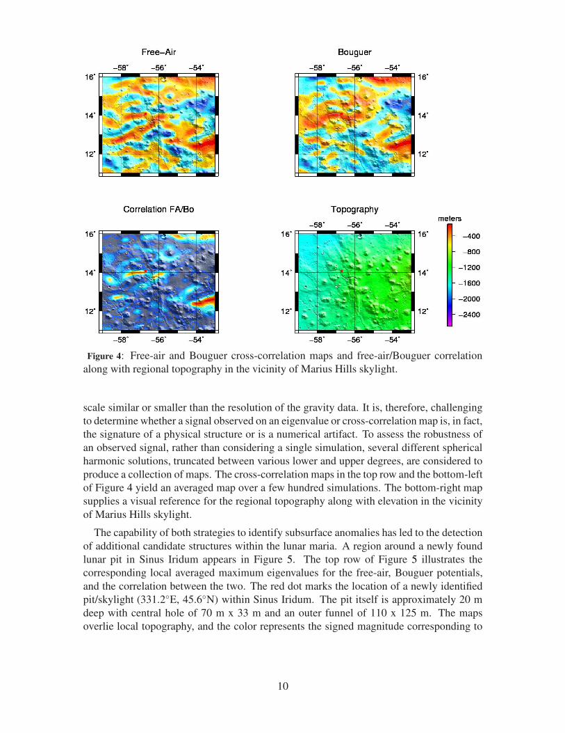
Figure 4: Free-air and Bouguer cross-correlation maps and free-air/Bouguer correlation
along with regional topography in the vicinity of Marius Hills skylight.
scale similar or smaller than the resolution of the gravity data. It is, therefore, challenging
to determine whether a signal observed on an eigenvalue or cross-correlation map is, in fact,
the signature of a physical structure or is a numerical artifact. To assess the robustness of
an observed signal, rather than considering a single simulation, several different spherical
harmonic solutions, truncated between various lower and upper degrees, are considered to
produce a collection of maps. The cross-correlation maps in the top row and the bottom-left
of Figure 4 yield an averaged map over a few hundred simulations. The bottom-right map
supplies a visual reference for the regional topography along with elevation in the vicinity
of Marius Hills skylight.
The capability of both strategies to identify subsurface anomalies has led to the detection
of additional candidate structures within the lunar maria. A region around a newly found
lunar pit in Sinus Iridum appears in Figure 5. The top row of Figure 5 illustrates the
corresponding local averaged maximum eigenvalues for the free-air, Bouguer potentials,
and the correlation between the two. The red dot marks the location of a newly identified
pit/skylight (331.2◦E, 45.6◦N) within Sinus Iridum. The pit itself is approximately 20 m
deep with central hole of 70 m x 33 m and an outer funnel of 110 x 125 m. The maps
overlie local topography, and the color represents the signed magnitude corresponding to
10
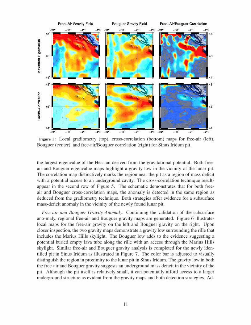
Figure 5: Local gradiometry (top), cross-correlation (bottom) maps for free-air (left),
Bouguer (center), and free-air/Bouguer correlation (right) for Sinus Iridum pit.
the largest eigenvalue of the Hessian derived from the gravitational potential. Both free-
air and Bouguer eigenvalue maps highlight a gravity low in the vicinity of the lunar pit.
The correlation map distinctively marks the region near the pit as a region of mass deficit
with a potential access to an underground cavity. The cross-correlation technique results
appear in the second row of Figure 5. The schematic demonstrates that for both free-
air and Bouguer cross-correlation maps, the anomaly is detected in the same region as
deduced from the gradiometry technique. Both strategies offer evidence for a subsurface
mass-deficit anomaly in the vicinity of the newly found lunar pit.
Free-air and Bouguer Gravity Anomaly: Continuing the validation of the subsurface
ano-maly, regional free-air and Bouguer gravity maps are generated. Figure 6 illustrates
local maps for the free-air gravity on the left and Bouguer gravity on the right. Upon
closer inspection, the two gravity maps demonstrate a gravity low surrounding the rille that
includes the Marius Hills skylight. The Bouguer low adds to the evidence suggesting a
potential buried empty lava tube along the rille with an access through the Marius Hills
skylight. Similar free-air and Bouguer gravity analysis is completed for the newly iden-
tified pit in Sinus Iridum as illustrated in Figure 7. The color bar is adjusted to visually
distinguish the region in proximity to the lunar pit in Sinus Iridum. The gravity low in both
the free-air and Bouguer gravity suggests an underground mass deficit in the vicinity of the
pit. Although the pit itself is relatively small, it can potentially afford access to a larger
underground structure as evident from the gravity maps and both detection strategies. Ad-
11
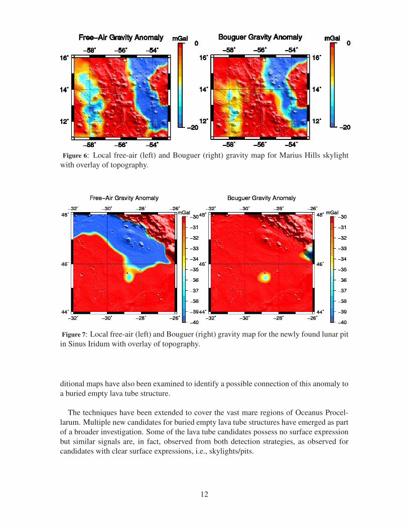
Figure 6: Local free-air (left) and Bouguer (right) gravity map for Marius Hills skylight
with overlay of topography.
Figure 7: Local free-air (left) and Bouguer (right) gravity map for the newly found lunar pit
in Sinus Iridum with overlay of topography.
ditional maps have also been examined to identify a possible connection of this anomaly to
a buried empty lava tube structure.
The techniques have been extended to cover the vast mare regions of Oceanus Procel-
larum. Multiple new candidates for buried empty lava tube structures have emerged as part
of a broader investigation. Some of the lava tube candidates possess no surface expression
but similar signals are, in fact, observed from both detection strategies, as observed for
candidates with clear surface expressions, i.e., skylights/pits.
12
CONCLUSIONS
As a result of the subsurface gravity gradient analysis, several candidate sites have been
recognized with a gravitational signature similar to that of a buried empty lava tube. Some
of these sites are in the vicinity of known sinuous rilles and skylights visible on the lunar
surface. Although the GRAIL mission did result in determining the lunar gravity to an
unprecedented precision, small scale features, such as smaller lava tubes and skylights, are
beyond the resolution of the data. In addition, the near polar orbit of the GRAIL spacecraft
introduced a North-South bias in the measurements. The Lunar Advanced Radar Orbiter
for Subsurface Sounding (LAROSS) spacecraft offers an extension of the findings of the
GRAIL mission by exploring sites with potentially buried empty lava tubes and an expan-
sion of the process to the whole mare region in search of smaller lava tubes. The low alti-
tude passes of the radar sounder over the mare region will aid in obtaining better resolution
and penetrating deeper below the lunar surface. This experiment will assist in the search
for buried empty lava tubes that may offer the potential to access and construct habitats,
safe from harsh surface environment and, thus, enabling future human exploration.
ACKNOWLEDGMENTS
The research work described in this paper made use of GRAIL data and was carried
out at Purdue University. The GRAIL mission is supported by the NASA Discovery Pro-
gram under contract to the Massachusetts Institute of Technology and the Jet Propulsion
Laboratory, California Institute of Technology.
13
REFERENCES
[1] M. T. Zuber, D. E. Smith, D. H. Lehman, T. L. Hoffman, S. W. Asmar, and M. M. Watkins, “GravityRecovery and Interior Laboratory (GRAIL): Mapping the lunar interior from crust to core,” SpaceScience Reviews, Vol. 178, No. 1, 2013, pp. 3–24.
[2] L. Chappaz, R. Sood, K. C. Howell, and H. J. Melosh, “Buried Empty Lava Tube Detection with GRAILData,” AIAA/AAS Astrodynamics Specialist Conference Conference and Exposition, American Instituteof Aeronautics and Astronautics (AIAA), aug 2014.
[3] J. Haruyama, K. Hioki, M. Shirao, T. Morota, H. Hiesinger, C. H. v. d. Bogert, H. Miyamoto,A. Iwasaki, Y. Yokota, M. Ohtake, et al., “Possible lunar lava tube skylight observed by SELENEcameras,” Geophysical Research Letters, Vol. 36, No. 21, 2009.
[4] D. G. Angelis, J. Wilson, M. Clowdsley, J. Nealy, D. Humes, and J. Clem, “Lunar lava tube radiationsafety analysis,” Journal of radiation research, Vol. 43, No. Suppl, 2002, pp. S41–S45.
[5] C. L. York, B. Walden, T. L. Billings, and P. D. Reeder, “Lunar lava tube sensing,” New Technologiesfor Lunar Resource Assessment, Vol. 1, 1992, pp. 51–52.
[6] G. Cushing, T. Titus, J. Wynne, and P. Christensen, “THEMIS observes possible cave skylights onMars,” Geophysical Research Letters, Vol. 34, No. 17, 2007.
[7] R. J. Leveille and S. Datta, “Lava tubes and basaltic caves as astrobiological targets on Earth and Mars:a review,” Planetary and Space Science, Vol. 58, No. 4, 2010, pp. 592–598.
[8] L. Keszthelyi, W. Jaeger, A. McEwen, L. Tornabene, R. A. Beyer, C. Dundas, and M. Milazzo, “HighResolution Imaging Science Experiment (HiRISE) images of volcanic terrains from the first 6 monthsof the Mars Reconnaissance Orbiter primary science phase,” Journal of Geophysical Research: Planets(1991–2012), Vol. 113, No. E4, 2008.
[9] C. Parcheta, “Lava flows in the Tharsis region of Mars: estimates of flow speeds and volume fluxes,”HSGC Report Number 06-14, 2005, p. 88.
[10] J. Bleacher, R. Greeley, D. Williams, and G. Neukum, “Comparison of effusive volcanism at Olympus,Arsia, Pavonis, and Ascraeus Montes, Mars from lava flow mapping using Mars Express HRSC data,”37th Lunar and Planetary Science Conference. Abstract, Vol. 1182, 2006.
[11] L. C. Simonsen, J. E. Nealy, L. W. Townsend, and J. W. Wilson, “Radiation exposure for manned Marssurface missions,” tech. rep., National Aeronautics and Space Administration, Hampton, VA (USA).Langley Research Center, 1990.
[12] B. A. Cantor, P. B. James, M. Caplinger, and M. J. Wolff, “Martian dust storms: 1999 Mars orbitercamera observations,” Journal of Geophysical Research: Planets (1991–2012), Vol. 106, No. E10,2001, pp. 23653–23687.
[13] B. E. Walden, T. L. Billings, C. L. York, S. L. Gillett, and M. V. Herbert, “Utility of lava tubes on otherworlds,” Using in situ Resources for Construction of Planetary Outposts, Vol. 1, 1998, p. 16.
[14] A. G. Fairen, J. M. Dohm, E. R. Uceda, A. P. Rodrıguez, V. R. Baker, D. Fernandez-Remolar,D. Schulze-Makuch, and R. Amils, “Prime candidate sites for astrobiological exploration through thehydrogeological history of Mars,” Planetary and Space Science, Vol. 53, No. 13, 2005, pp. 1355–1375.
[15] D. Schulze-Makuch, L. N. Irwin, J. H. Lipps, D. LeMone, J. M. Dohm, and A. G. Fairen, “Scenariosfor the evolution of life on Mars,” Journal of Geophysical Research: Planets (1991–2012), Vol. 110,No. E12, 2005.
[16] J. Blamont, “A roadmap to cave dwelling on the Moon and Mars,” Advances in Space Research, Vol. 54,No. 10, 2014, pp. 2140–2149.
[17] J. W. Head and A. Gifford, “Lunar mare domes: classification and modes of origin,” The moon and theplanets, Vol. 22, No. 2, 1980, pp. 235–258.
[18] P. D. Spudis, P. J. McGovern, and W. S. Kiefer, “Large shield volcanoes on the Moon,” Journal ofGeophysical Research: Planets, Vol. 118, No. 5, 2013, pp. 1063–1081.
[19] J. C. Andrews-Hanna, J. Besserer, J. W. Head III, C. J. Howett, W. S. Kiefer, P. J. Lucey, P. J. McGovern,H. J. Melosh, G. A. Neumann, R. J. Phillips, et al., “Structure and evolution of the lunar Procellarumregion as revealed by GRAIL gravity data,” Nature, Vol. 514, No. 7520, 2014, pp. 68–71.
[20] P. Lucey, B. Hawke, C. Pieters, J. Head, and T. McCord, “A compositional study of the Aristarchusregion of the Moon using near-infrared reflectance spectroscopy,” Lunar and Planetary Science Con-ference Proceedings, Vol. 16, 1986, p. 344.
[21] J. Head and L. Wilson, “The formation of eroded depressions around the sources of lunar sinuous rilles:Observations,” Lunar and Planetary Science Conference, Vol. 11, 1980, pp. 426–428.
[22] W. B. Garry and J. E. Bleacher, “Emplacement scenarios for Vallis Schroteri, Aristarchus Plateau, theMoon,” Geological Society of America Special Papers, Vol. 477, 2011, pp. 77–93.
14
[23] L. J. Porcello, R. L. Jordan, J. S. Zelenka, G. F. Adams, R. J. Phillips, W. E. Brown Jr, S. H. Ward, andP. L. Jackson, “The Apollo lunar sounder radar system,” Proceedings of the IEEE, Vol. 62, No. 6, 1974,pp. 769–783.
[24] J. Mouginot, A. Pommerol, P. Beck, W. Kofman, and S. M. Clifford, “Dielectric map of the Martiannorthern hemisphere and the nature of plain filling materials,” Geophysical research letters, Vol. 39,No. 2, 2012.
[25] N. E. Putzig, R. J. Phillips, B. A. Campbell, M. T. Mellon, J. W. Holt, and T. C. Brothers, “SHARADsoundings and surface roughness at past, present, and proposed landing sites on Mars: Reflections atPhoenix may be attributable to deep ground ice,” Journal of Geophysical Research: Planets, Vol. 119,aug 2014, pp. 1936–1949, 10.1002/2014je004646.
[26] A. Pommerol, W. Kofman, J. Audouard, C. Grima, P. Beck, J. Mouginot, A. Herique, A. Kumamoto,T. Kobayashi, and T. Ono, “Detectability of subsurface interfaces in lunar maria by the LRS/SELENEsounding radar: Influence of mineralogical composition,” Geophysical Research Letters, Vol. 37, No. 3,2010.
[27] Y. Su, G.-Y. Fang, J.-Q. Feng, S.-G. Xing, Y.-C. Ji, B. Zhou, Y.-Z. Gao, H. Li, S. Dai, Y. Xiao, et al.,“Data processing and initial results of Chang’e-3 lunar penetrating radar,” Research in Astronomy andAstrophysics, Vol. 14, No. 12, 2014, p. 1623.
[28] G.-Y. Fang, B. Zhou, Y.-C. Ji, Q.-Y. Zhang, S.-X. Shen, Y.-X. Li, H.-F. Guan, C.-J. Tang, Y.-Z. Gao,W. Lu, et al., “Lunar Penetrating Radar onboard the Chang’e-3 mission,” Research in Astronomy andAstrophysics, Vol. 14, No. 12, 2014, p. 1607.
[29] L. Bruzzone, G. Alberti, C. Catallo, A. Ferro, W. Kofman, and R. Orosei, “Subsurface radar soundingof the Jovian moon Ganymede,” Proceedings of the IEEE, Vol. 99, No. 5, 2011, pp. 837–857.
[30] R. Seu, D. Biccari, R. Orosei, L. Lorenzoni, R. Phillips, L. Marinangeli, G. Picardi, A. Masdea, andE. Zampolini, “SHARAD: The MRO 2005 shallow radar,” Planetary and Space Science, Vol. 52, No. 1,2004, pp. 157–166.
[31] B. Cooper, “Apollo 17 Lunar Sounder Data Provide Insight into Aitken Crater’s Subsurface Structure,”Lunar and Planetary Science Conference, Vol. 39, 2008, p. 2369.
[32] T. Ono and H. Oya, “Lunar Radar Sounder (LRS) experiment on-board the SELENE spacecraft,” Earth,planets and space, Vol. 52, No. 9, 2000, pp. 629–637.
[33] M. Zuber, D. Smith, S. Asmar, A. Konopliv, F. Lemoine, H. Melosh, G. Neumann, R. Phillips,S. Solomon, M. Watkins, et al., “Gravity Recovery and Interior Laboratory (GRAIL): extended missionand endgame status,” Lunar and Planetary Science Conference, Vol. 44, 2013, p. 1777.
[34] F. G. Lemoine, S. Goossens, T. J. Sabaka, J. B. Nicholas, E. Mazarico, D. D. Rowlands, B. D. Loomis,D. S. Chinn, G. A. Neumann, D. E. Smith, et al., “GRGM900C: A degree 900 lunar gravity model fromGRAIL primary and extended mission data,” Geophysical Research Letters, Vol. 41, No. 10, 2014,pp. 3382–3389.
[35] A. S. Konopliv, R. S. Park, D.-N. Yuan, S. W. Asmar, M. M. Watkins, J. G. Williams, E. Fahnestock,G. Kruizinga, M. Paik, D. Strekalov, et al., “High-resolution lunar gravity fields from the GRAILPrimary and Extended Missions,” Geophysical Research Letters, Vol. 41, No. 5, 2014, pp. 1452–1458.
15