a vision for talca's future
DESCRIPTION
Urban Planning studio project.TRANSCRIPT
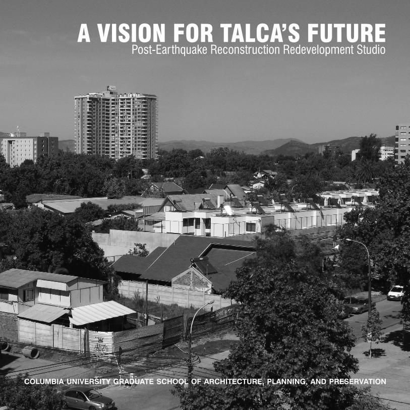
A VISION FOR TALCA’S FUTUREPost-Earthquake Reconstruction Redevelopment Studio
COLUMBIA UNIVERSITY GRADUATE SCHOOL OF ARCHITECTURE, PLANNING, AND PRESERVATION

2
Collin AndersonJuan Pablo AzaresYizhou FengNorabelle GreenbergerJinny KhandujaJulia LewisMadeeha MerchantLucre MontemayorCarolina MontillaMax Podemski Lucy RobsonAllison Schwartz
Special thanks to:Assistant Professor: Clara IrazabalAdjunct Professor: Alejandro CastroTeacher’s Assistant: Jordan Salinger
Client: SERVIUCollaborators: Catholic University of Maule

3
A VISION FOR TALCA’S FUTUREPost-Earthquake Reconstruction Redevelopment Studio

4

5
TABLE OF CONTENTS
Purpose & Task
Background & Context Talca Barrio Las Heras Earthquake Post-Earthquake
Analysis Strengths Weaknesses Opportunities Threats
Vision Lot Block Neighborhood
Implementation Time Scale Replicability People
Appendix Community Land Trusts Land Readjustment Land Value Capture
References
12345
678910
1112131415
1617181920
21

6

7
PURPOSE & TASK
In September 2012, SERVIU, the regional arm of the Chilean Ministry of Housing and Urban Development (MINVU), tasked our program with evaluating and reassessing housing reconstruction efforts in Talca, the capital city of the Maule region, in the wake of the 2010 earthquake that affected the region. To carry out this task, we focused on a case study neighborhood in Talca’s historic center, Barrio Las Heras. This document provides the synthesis of fourteen weeks working on the project, including a presentation of the context, our assessment of the strengths and weaknesses of the reconstruction efforts to date, and recommendations for Talca’s future development.

8

9
BACKGROUND & CONTEXT
This provides a brief introduction to Talca’s physical, social and historical context leading up to the 2010 earthquake and the various actors and projects initiated in its wake.

10
BACKGROUND &CONTEXT
TALCA
Physical ContextTalca is the city of approximately 250,000 located in Chile’s Maule Region, 158 miles south of the country’s capital city, Santiago. The city follows a regular grid pattern, which is most evident in the city’s historic center. The urban form of the historic center is typical of traditional Chilean cities, with a strong grid pattern organized around a city square called Plaza las Armas, the pillar of the city’s civic identity, and a major boulevard with a center median park, the Alameda, located three blocks to the north.
Historical ContextTalca was originally founded in 1692 by Tomás Marin de Poveda, and refounded as Villa Dan Agustín de Talca in 1741. The city is the political capital of the Maule region, and has served as an important economic and cultural center of the region and the country throughout its history, including being the site of Bernardo O’Higgins’s signing of the Chilean Declaration of Independence in 1818.
During the nineteenth century, Talca was a
thriving economic center, owed to booming agricultural and manufacturing industries in the region, including wheat, wine, paper, food, and leather. These products were exported to cities across the globe. The presence of the local agricultural land-owning aristocracy brought great wealth to the city, and resulted in the development of a trolley system and the construction of magnificent architectural works such as the Bank of Talca, Teatro Municipal, and the city’s train station. These landmarks, as well as many grand homes with distinct architectural features, symbolized Talca’s progress and growth.
An influx of populations from cities such as Santiago and Valparaiso, as well as from Europe, gave the city of Talca a cosmopolitan reputation as a modern cultural hub, and even resulted in the now commonly used marketing phrase “Talca, Paris, y Londres.” The city was also well known for its intellectual and literary scene, with various academic institutes, newspapers, and famous historians and professionals residing in the city.
A major earthquake in 1928 followed by the Great Depression in 1930 resulted in a movement of the population out of the city center, and diminished the national importance of Talca as an economic powerhouse. However, much of the historical fabric of the city remained as a reminder of its former splendor.
In the 1980’s, industry began to flourish once again, as fledgling trade activities and services derived from agriculture and
Social ContextBefore the earthquake 20 percent of Talca residents lived in the central district within which Barrio Las Heras is located. It was a place of great social mixing, with older residents who had lived in the neighborhood for generations, and younger students informally renting accessory units or rooms. Given the high value of central district land, this area represented a unique mix of social classes, as Chile has one of the greatest income gaps among developed countries. Additionally, the presence of many long-term residents who led traditional Chilean lifestyles contributed to the neighborhood’s strong sense of community.
EARTHQUAKE
On February 27, 2010, the sixth largest earthquake in world history wreaked havoc on Chile, affecting 12.8 million people. Talca lies less than 100 kilometers from the epicenter of the 8.8 magnitude earthquake, and the city was severely damaged; a year after the quake, the municipality of Talca declared nearly 11 thousand homes uninhabitable. 40 percent of the buildings in the city’s historic center were affected, a majority of which were built prior to the succession of strict national building codes implemented throughout the twentieth century.
The abrupt change in the physical landscape due to the earthquake left Talca with a severe need for housing, and a massively displaced population. Without
Talca
Santiago
MAULE REGION
Map of Chile
Talca, Chile

11
livestock regained strength for the city’s economy, reflecting trends of past growth.
BARRIO LAS HERAS
Physical ContextThe neighborhood of Barrio las Heras is situated one block north of the Alameda, and is bounded by Nueve Norte to the north, Ocho Orients to the east, Cinco Norte to the south, and Tres Oriente to the west. In total, the neighborhood consists of 24 regularly shaped 400-foot by 400-foot city blocks ringing the Plaza las Heras, a large public square with gathering spaces, including a skateboarding park, seating areas, and plantings.
In contrast to the regular form of Barrio Las Heras’ blocks, the building lots that comprise them are irregular in shape, and appear unplanned, the result of successive divisions and re-parceling measures. Lots range in size, with buildings typically situated to the front of the lot. In general, the lots are occupied by compact one-story houses along the street frontage, with large interior lot areas, which remain empty as yards or developed with informal ad-hoc structures.
The neighborhood is residential in character, with a handful of small neighborhood grocers. A school is located on the block to the northeast of the central plaza, as well as a church, a gathering space for the community center, and an auto repair shop.
Social ContextBefore the earthquake 20 percent of Talca residents lived in the central district within which Barrio Las Heras is located. It was a place of great social mixing, with older residents who had lived in the neighborhood for generations, and younger students informally renting accessory units or rooms. Given the high value of central district land, this area represented a
unique mix of social classes, as Chile has one of the greatest income gaps among developed countries. Additionally, the presence of many long-term residents who led traditional Chilean lifestyles contributed to the neighborhood’s strong sense of community.
THE ALAMEDA
PLAZA LAS ARMAS
BARRIO LASHERAS
Historic Center of Talca

12
BACKGROUND &CONTEXT
involved to address the devastation and displacement.
POST-EARTHQUAKE
A Vision for TalcaIn the wake of the earthquake, DUPLA Architects developed a Master Plan for the Reconstruction of Talca; this has guided
the reconstruction efforts and development since its release. The plan highlights four main goals: the improvement of public spaces, the redevelopment of the waterfront, the creation of a mixed-use neighborhood around the train station, and increased density within the city’s historic center.
EARTHQUAKE
On February 27, 2010, the sixth largest earthquake in world history wreaked havoc on Chile, affecting 12.8 million people. Talca lies less than 100 kilometers from the epicenter of the 8.8 magnitude earthquake, and the city was severely damaged; a year after the quake, the municipality of Talca declared nearly 11 thousand homes uninhabitable. 40 percent of the buildings in the city’s historic center were affected, a majority of which were built prior to the succession of strict national building codes implemented throughout the twentieth century.
The abrupt change in the physical landscape due to the earthquake left Talca with a severe need for housing, and a massively displaced population. Without an established reconstruction plan or an emergency management agency at the national, regional, or local levels, many public, private and nonprofit actors became
Damaged adobe structure in Barrio Las Heras Map data from SERVIU

13
Growth of the CityAccording to the 2012 decennial Census, the city of Talca grew by 23.88 percent between 2002 and 2012 – a significantly greater rate than the national population growth of 15.1 percent over the same period. Given the city’s low average birth rate of 1.9, factors other than natural growth appear to have been at play. Two possible explanations of this population increase are the expansion of the city’s limits in 2010 and the boom in housing construction that occurred after the earthquake.
Expansion of the City LimitsThe Municipal Secretariat for Planning’s 2010 Regulatory Plan expanded Talca’s city limits significantly to the north and the east, tripling the area of the city from 300,000 ha to 900,000 ha. The plan responded to the 2010 earthquake, and intended to complement the Master Plan developed by DUPLA.
The Regulatory Plan governs the growth of the regional capital for the next 30 years. The plan divides the city by land use such as residential, industrial, tourist, commercial, and green areas, among others. A new focus of the plan is on the developing agricultural manufacturing region to the north of the city, and a connection to an international highway to Argentina (with accompanying services and support industry) to the southeast of the city, made possible by the expansion of the city limits.
New Housing ConstructionSERVIU and SEREMI, as regional representatives of MINVU, developed the subsidies originally created by MINVU to meet the specific needs of the Maule region. These subsidies address the owners of the 47,629 homes damaged in the region. In Talca, the efforts of these agencies have been informed by the Master Plan for Reconstruction.
The physical manifestations of SERVIU’s post-earthquake housing reconstruction efforts have taken several forms: large-scale residential buildings in the city center, made possible through densification subsidies; in-situ temporary homes; in-
situ prefabricated homes, some of which conform with the city center’s traditional continuous facades; large stretches of replacement housing located outside of the city center and large-scale mixed-income apartment buildings located to the periphery of the city center.
Private sector developers work closely with SERVIU constructing these new housing developments throughout the city. In the center of the city, a large number of now-vacant lots led to speculation, as private developers sought both to make use of MINVU’s new densification subsidies and to construct other forms of housing. These include gated row house developments,
Subsidy Chart

14
BACKGROUND & CONTEXT
Actors
MINVU is the Ministry of Housing and Urban Development of Chile. In the aftermath of the earthquake, they were given the task of developing
a plan for reconstructing the country’s destroyed houses and established the National Reconstruction Program.
SERVIU, the housing and urban development service, is the regional policy enforcer of MINVU. They provide
technical assistance for displaced families and serve as the in-between for private developers and future residents.
SEREMI are MINVU’s regional secretariat. As part of the National R e c o n s t r u c t i o n Program, SEREMI enacts policies and programs at the
regional level.
CEUT, the center for urban and territorial studies is an institute that focuses on both urban design and planning research. This institute is an initiative of the Catholic University of Maule.
Prefabricated Housing in Talca Mixed-Income Medium-Density in Talca Incremental Housing in Constitucion
SurMaule is an NGO made up of academics and community members whose goal is to strengthen democracy by building a better connection between citizens and policy makers. They take a critical view of the reconstruction process and believe that the reconstruction plan has had little oversight and is serving the interests of the market, leading to an expansion of the urban area and densification of the center without the implementation of proper services. Surmaule has an extremely contentious relationship with SERVIU and there is little communication between the two organizations.

15
which have proliferated in Barrio Las Heras. These developments increased density on some of the large narrow lots found throughout the neighborhood without increasing building height.
Housing development patterns in Talca emergent following the earthquake mirror activity in the greater Chilean housing market, which favors buying over renting. The second quarter of 2012 witnessed a 35 percent growth in homeownership in Chile. A higher standard of amenities is also being requested by Chileans, reflected in high housing construction costs per square foot; these average $160 US dollars and are comparable to costs in U.S. cities, such as Chicago, which has an average housing construction cost of $158 per square foot.
Community, Nonprofit, and Academic InitiativesIn reaction to and in conjunction with
the housing reconstruction occurring throughout Talca, several community, nonprofit, and academic organizations have come to the forefront. These seem to either show support for, or researching new mechanisms for addressing the problems that remain.
SurMauleAs one of the most active non-profit groups involved in Talca’s housing reconstruction, Surmaule has taken a publicly critical view of the reconstruction process. It believes that the Reconstruction Plan has had little oversight and is serving the interests of the market, leading to an expansion of the urban area and densification of the center without the implementation of proper services. Surmaule has a contentious relationship with SERVIU, and there is little communication between the two organizations.
Community GroupsNeighborhood groups are self-organizing amidst the reconstruction process. The Barrio San Antonio neighborhood, west of Las Heras, is one such example. Residents of this historic neighborhood object to the areas new development, which does not form a street way and so is diminishing connections to the street.
Academic Research and SupportThe architecture school at the University of Talca has played a critical role in the rebuilding efforts, as many student projects have focused on developing new housing models for displaced residents. Within the Catholic University of Maule, CEUT, the Center for Urban and Territorial Studies, has developed strategies for the rebuilding effort.
Multi-Family Low Rise Multi-Family High RiseSingle Family Home

16

17
ANALYSIS
Given the variety of actors and complexity of reconstruction efforts thus far, an analysis of the successes, weaknesses, opportunities and threats associated with the current approaches is key in guiding future recommendations.

18
STRENGTHS
One of the major strengths of the reconstruction effort has been the diversity of subsidies and housing options; the breadth of these alludes to the need for multiple solutions. Through the diversity of housing options, a large number of those affected by the earthquake have been relocated to new homes, or provided with new homes on their existing properties. The goals of many of the reconstruction subsidies have also successfully incorporated broader urban issues, such as densification, mixed-income development, and preservation.
Lastly, Talca’s reconstruction plans express a vision for the future by highlighting a renewed interest in smart, sustainable, and stronger planning for this country prone to natural disasters.
WEAKNESSES
Many of the goals of MINVU’s housing subsidies and programs have not been achieved. The diversity of programs has spurred eclectic and uncontrolled construction and development, which has led to a loss of neighborhood character, particularly in the center of the city. This loss of character is exacerbated by densification projects and some of the continuous facade buildings, which abandon traditional vernacular construction methods and contrast with the city’s typical architectural styles. Although the goal of the continuous facade subsidy is to integrate new buildings with the historic fabric, the change of the historic center’s setback in the new Regulatory Plan undermines the effort. The result is an a contextual building type that contradicts the fabric of the neighborhood.
Additionally, the displacement of center-city residents to the city’s periphery further
dissolves community ties and decreases accessibility. Issues of accessibility and increased auto-dependency is also a result of the lack of mixed-use developments. Reconstruction efforts have focused on providing housing, overlooking needs for essential services. This has been one of the central criticisms of the reconstruction efforts from non profits like SurMaule.
Finally, there is a lack of institutional coordination between the involved actors to address the many remaining abandoned and demolished lots throughout the city center. Given the number of public, private, and nonprofit actors involved in the reconstruction, and despite their shared goals for rebuilding the city and rehousing its residents, coordination issues are a major barrier to the success of Talca’s reconstruction.
ANALYSIS
Densification efforts Mixed-income projects Resilience planning
STRENGTHS

19
OPPORTUNITIES
SERVIU has stated an interest in taking a broader community approach. Its openness to community empowerment offers the opportunity to define and address some of the broader community goals that deserve equal attention. Furthermore, the abundance of vacant lots in the center of the city offer potential sites for implementation of such community-based plans.
THREATS
It is imperative that a reassessment of both the ongoing reconstruction efforts and the vision for Talca’s future is performed before certain irreversible construction plans take effect. The current patterns of displacement do not appear to be slowing, and these continue to undermine the sense of community character and its nature of social mixing, which were strong in the city center prior to the 2010 earthquake.
Additionally, though housing production is a means for economic development and job creation, research is beginning to show that current rates of construction outweigh real demand. This is an unsustainable form of economic development. A more diverse vision of Talca’s economic future is needed to ensure the viability of the city and its residents.
Rampant development
No mixed-use projects
Historic facade loss
Periphery projects Vacant + abandoned
WEAKNESSES

20

21
VISION
Given this context, a new vision for reconstruction that better exhibits the city’s unique design and cultural assets is necessary. Reconstruction efforts should encourage development and local economic growth that fits with and promotes preservation of Talca’s rich historic and social fabric.

22
VISION

23
$
Develop Connect Preserve and Promote
Lot Block Neighborhood
INTRODUCTION
The project operates on different levels to achieve diverse goals for Talca. At the lot level the implementations work to connect people. On the lot level connections efforts
are made to encourage mixed use and infill. On the block level, it is recommended that develolpers create pathways through the blocks, generating more options for
housing. On the neighborhood level, preservation of the existing structures and incorporation into new projects is required to retain the visual culture of Talca.

24
VISION
LOT
BackgroundTalca’s reconstruction efforts can be summed up in one word: housing. Little thought has been given to broader community goals, evident in both the deficiency of community involvement and single-use nature of the development that has occurred. Local residents are given little say in the future of their city and of their community, and local businesses destroyed by the earthquake are forced out.
GoalAt the scale of the individual lot, this project seeks to encourage mixed-use community development by promoting defined sites of neighborhood identity, increased available mixed-use program and community public spaces. The organization of these regional hubs of activity is intended as a sustainable form of development that would strengthen
neighborhood character. Additionally, the lots will offer live-work housing alternatives and affordable housing units through government-delivered subsidies. Imperative to the program and use of these sites is community involvement, to encourage self-sufficiency both in the short and long term.
Physical FormAs an intervention that would happen at the lot level, this program would first require the identification of Priority Development Sites throughout the city, each centered around a central existing hub of activity. One such example is a currently vacant lot adjacent to the plaza of Barrio Las Heras; the site would offer mixed-use space that would work in tandem with the activity of the plaza. To carry out the goals of strengthening community character and economic activity within the neighborhood, short-
term solutions on these sites (prior to construction) include programs such as pop up markets, community gardens, and art spaces. Through policies, incentives, and guidelines, Priority Development Sites would be developed with public community space and basic neighborhood businesses and services on the first floor, office and studio space on the second and third stories, and subsidized live/work co-op units above. The following steps for implementation are proposed, with specified actors:1. Initiate program (SEREMI)2. Define Priority Development Sites (Municipality and SERVIU)3. Designate priority lots (SERVIU)4. Determine community hub goals (Community)5. Develop hub-specific design & building program guidelines (Municipality and SEREMI)6. Initiate hub promotion activities (Community & Ministry of Internal Economic Affairs)7. Develop priority sites (Developers and SERVIU)8. Annual vote on Community Hub Improvement District-funded programs (Community)

25
Hub Precedents
Mart 125Mart 125 Redevelopment on Manhattan’s 125th Street is a property located in an area with a history of arts venues. The city-owned property is being redeveloped by NYCEDC (New York City Economic Development Corp.) in an effort to transform the region into a cultural and entertainment destination. Redevelopment program includes over 10,000 square feet of cultural space, 800 square feet of visitor center space, and 2,500 square feet for retail and café programming, with local businesses given priority for retail leases. The project intends to incentivize the development of a regional business district, as the starting point for a larger culture and arts corridor spanning from the Harlem River to the Hudson River in Manhattan’s Upper West Side. Following 2008 rezoning measures to support such civic programming, the redevelopment is being led by an advisory committee of 100 local stakeholders, which includes
elected officials, community boards, civic groups, and cultural institutions.Reference: www.nycedc.com
Business Improvement Districts Business improvement districts (BIDs) are defined regions within which local businesses pay a fee or taxes to fund improvements within that region. New York City, for instance, has nearly 70 BIDs. One example of these, the Bryant Park BID, run by the Bryant Park Corporation (BPC), a not-for-profit company made up of neighboring property owners. This company was formed to renovate the historic park, which was in poor condition in the 1980s. In 1988, management of the public park was handed over to this private company, which renovated the park under a budget that was six times that which the city had previously operated it. The park reopened after a four-year renovation to great success.Reference: www.bryantpark.org
Priority Development SitesPriority Development Sites in Massachusetts offers communities tools for economic development. Signed into state law, Priority Development Site funding offers up to USD$150,000 in aids for everything from increased marketing and visibility of sites to professional staffing assistance, local government reorganization and brownfield remediation assistance. These community-selected sites must be zoned for commercial or industrial development and be eligible for at least 50,000 square feet of new building. Reference: Massachusetts General Law Chapter 43D, www.mass.gov
Cafe Literario, Santiago, Chile

26
PURPOSE & TASK

27
A variety of developer subsidies would aid in the implementation of this plan:
• A Centrality Subsidy for targeted and concentrated development. The existing location subsidy is to be streamlined with the community hub policy, giving additional subsidies for developing on community hub priority lots.• A Readjustment Subsidy to discourage displacement. Developers are given an additional subsidy if the existing landowner is given a housing unit in the development.• A Basic Services Subsidy to encourage self-sufficient communities. Developers receive an additional subsidy if they include one
of the list of priority neighborhood services on their site.
Priority Development Site guidelines are proposed as follows:
1. All development on community hub priority sites must be mixed-use. Ground floor uses must incorporate public community spaces, programmed by each community hub through a vote. Each site must include a minimum of one floor of commercial office use. Each site must include a minimum of one floor of residential uses. For each additional floor of commercial office use, one additional floor of residential use must
be provided.
2. Programs accommodating local businesses and local labor are prioritized. Former businesses destroyed by the earthquake are given first priority. Businesses on community hub priority sites must prioritize community hub resident labor.
3. All development on community hub priority sites must follow SEREMI’s hub-specific design guidelines.
4. Community Hub Improvement District (CHID) All priority site owners must contribute annually to the CHID.

28
VISION
BLOCK
BackgroundNew development in the Plaza Las Heras neighborhood has introduced a profoundly different urban fabric. This new fabric is typified by two main qualities: higher density and the prioritization of automobiles. Row houses that take advantage of the long narrow lots to penetrate the inside the block and which often feature a gated driveway have proliferated throughout the community. Many of these developments predate the earthquake and they are likely to increase as rebuilding continues. There are currently at least four examples of this typology in the Plaza Las Heras neighborhood alone.
Goal
While many traditional adobe houses in the neighborhood lay vacant or damaged there has been a high demand for the new building types. However, these new
developments must be better integrated into the historic and social fabric of the area. A prized quality of the Plaza Las Heras neighborhood for many long time residents is it’s strong sense of community. While the new row house developments are very different from the neighborhood’s traditional form, there are ways that this new building typology can be integrated to maintain the strong social tradition of the community.
Physical FormCar-oriented driveways should be converted into multi-modal laneways which connect through blocks. This will open up what are now private enclaves that are both physically and socially isolated from the broader community. It will also enhance circulation for community residents. and serve to turn the negative quality of the row houses into an asset.
In order to create the laneways a new
municipal regulation should be enacted banning the construction of private driveways for new developments. These features not only sever new developments from the rest of the community but are largely single purpose, accommodating automobiles. The fact that these driveways have one entrance channels large amounts of traffic onto neighborhood streets and diminishes the pedestrian environment.
Laneways Precedents
Virginia Cul De Sac BanThe state of Virginia passed a ban on non-connective streets in 2009. New developments in the state are required to have a certain level of connectivity, which, if a developer does not satisfy, revokes inclusion in local service provisions such as snow plowing. Streets in new developments must be through-streets, with more than one entrance, and no dead ends. Local streets also must be narrower, ranging from 24 to 29 feet, as opposed to the previously allowed 40 feet. The bill as a response to traffic congestion resulting from non-connective streets in subdivisions that let out large amounts of traffic onto busy roads. In addition the bill saves local municipalities a significant amount of money on road maintenance.
Chicago Permeable AlleyThe city of Chicago has instituted a program to put permeable paving in

29
Cady’s Alley, DC Post Alley, Seattle
the city's large amount of service alleys running in the middle of blocks. Instead of impermeable concrete paving, semi-permeable materials, such as bricks or stones, are used, allowing storm and snow runoff to be captured and purified on site instead of carrying polluting into nearby water bodies. This paving also has an aesthetic benefit because it can have a green appearance by way of the grass that grows between the stones or bricks.
Seattle Green FactorThe Green Factor program applies to new commercial and multifamily housing developments in Seattle. Developers are given points for including features such as large plants, permeable paving, green roofs, vegetated walls, and layering vegetation along streets and other areas visible to the public into their developments. Buildings can score additional points through providing areas for food cultivation, using native and drought-tolerant plants, and rainwater
harvesting. In order to be granted a building permit, developers must score a certain amount of Green Factor points, dependent on the building’s use.
Constitucion Elemental PlanThe coastal Chilean City of Constitucion was badly damaged by the 2010 earthquake and ensuing tsunami. In the aftermath, Santiago-based architecture firm Elemental was commissioned to create a Reconstruction Plan for the city. The firm led a broad-based outreach process, soliciting feedback from all aspects of the community as well as a diverse array of stakeholders to gain input on the plan. This engagement process empowered the community to lobby the government to see the plan realized. As a result, the plan not only articulates the community’s vision for the future but served a powerful catalyst for its implementation.
Sydney City Centre Laneway RevitalizationThe city of Sydney, Australia initiated a revitalization program to transform
the city’s large system of laneways in their central business district into vibrant, new community focal points. Large-scale capital improvements were conducted such as lighting, paving, providing additional space for outdoor dining, as well as traffic calming measures. Other improvements included encouraging permanent and temporary art installations.
Wellington, New Zealand: Laneways RegenerationThe city of Wellington created a collaborative approach to improve their system of laneways. The government cataloged laneways based on how important they were to the street network and connectivity and engaged property owners along the laneways to incorporate better urban design and land uses to activate and improve them.

30
VISION
LanewayDevelopment
Existing Townhouses
CommunityLot
Connectivity
Continuous Facade
Higher Density Block Interior
Traditional Density at Street
Commercial (formal)
Single Occupant Housing Unit
Rental Studio
Commercial (informal)
Small Family Housing Unit
Extended Family Housing Unit
Unit Diversity
Laneways are also an opportunity to promote green infrastructure and introduce a new means of connectivity into the neighborhood. The existing blocks in the neighborhood are relatively large with dimensions of 400 feet by 400 feet. Laneways will break up the block into smaller dimensions creating more connectivity. Green elements, such as permeable paving and plants can also be introduced to the laneways to treat and capture storm water run off.
Laneways will also allow new development and different typologies to be introduced, without disrupting its historic fabric. The laneways will open up new development opportunities to existing residents to build accessory units or sell their parcels, or a portion thereof, to developers. Targeting additional density will take development pressure off of existing streets where it could potential disrupt the historic character of the neighborhood. Introducing varying housing typology will allow a range of
demographics to live in the neighborhood, such as families, the elderly, and students.
The laneways scheme will incorporate an inclusive planning process to both strengthen the community and build ownership over the new pathways. The earthquake created vast physical as well as social disruption. Longtime residents were displaced and many neighborhood institutions have yet to reopen. This has been paired with an infusion of new residents who have moved into the many new developments. An inclusive planning process will be an opportunity to strengthen the community and allow residents to envision what they would like the Plaza Las Heras neighborhood to look like in the future.
A community visioning session should be held in Plaza Las Heras to plan the laneways. This will be an opportunity for both new and old residents to come together and, in some cases, meet each other for the first time.
Residents will be able to share memories of how the neighborhood was and how they would like it to be in the future. To ensure broad participation in this process, an outreach strategy should capitalize on current residents as well as community organizations to reach out to neighbors and encourage their participation.The community as a whole can decide where the laneways should go and what their general layout should be, such as pedestrians and bikes only, multi-modal etc. On the block level residents can plan various aspects of the path, such as vegetation, artwork, paving etc. This will create a coherency to the paths for the neighborhood as a whole while personalizing them at the hyper-local level. Community residents can further be involved in the process through constructing the paths and planting vegetation. Community participation can also be sustained in the long term through periodic maintenance days for the path.

31

32
VISION
NEIGHBORHOOD
BackgroundThe earthquake had an immediate effect on the historic adobe structures of Talca: many were badly damaged, some to the point of being uninhabitable. This damage has resulted in a context of real estate pressure, demolition, and replacement of historical structures that is fundamentally changing the spatial character of neighborhoods. Some of the new typologies are increasing density without disrupting the neighborhood’s fabric. These new developments, along with features from historic structures, could be used to develop design and spatial layout features that help to reestablish Talca’s identity for the future.
GoalAt the neighborhood level, this project seeks to preserve the existing historic fabric of buildings and layout while still
allowing for new development to blend in. The undamaged historic adobe structures currently in Barrio Las Heras would be preserved, and new development would either incorporate existing facades and structures on unaffected lots, or incorporate a percentage of design features that are consistent with Talca’s building typology and character. In addition, urban spatial design features such as interior courtyard would be encouraged. This neighborhood preservation strategy serves to strengthen and promote Talca’s character within the current context of growth.
Physical FormAs an intervention at the neighborhood level, this proposal would reestablish Plaza Las Heras as the hub of Barrio Las Heras, preserving its historical centrality, activity, and use as a vibrant public space.
To carry out the goal of complimentary preservation and growth, short and long
Historic Preservation Precedent
Although the context for historic preservation in Chile is not strong outside of wealthy historic barrios in Santiago, there are cases that resemble Talca more closely. The city of Chanco, Cauquenes Provine in the region of Maule, is one that is particularly relevant.
Chanco was given a “Zona Tipica” designation by the national Department of Historic Monuments in 1999 due to its neo-colonial style. Like Talca, many of its structures are constructed in historic adobe building techniques. The rationale for this designation included the existence of “one-floor colonial houses with continuous façade and corridors that create a strong urban identity and continuity.” Building details included “a variety of windows, doors, and gates with elaborate details and proportions, columns, lintels, and windowsills with exemplary carpentry, an interesting treatment of corners, rustic roofs, and wooden pillars of great architectural value.” The street layout and character of Chanco’s neighborhoods and spatial plan also played a key part in this designation, with reference to its traditional street network, identity as a former fishing village, and potential to draw tourists and visitors from other parts of Chile.
SCENARIO_01

33
term policies, incentives, and guidelines would be undertaken to guide reconstruction and new growth, with particular attention to historic neighborhood features.
Three strategies would be employed as initial steps toward this goal:
1) formalizing the “Fachada Continua” program that is already in existence2) repurposing existing adobe facades of structures that are still standing and incorporating them into higher density and newer typologies3) defining architectural elements to be preserved at an incremental scale throughout the neighborhood.
In order to reestablish the historical centrality of the plaza and define a currently nonexistent framework of preservation, three phases of guidelines, incentive policies, and regulations would be employed.
Guidelines:• Establishing partnerships with local actors (municipality, universities, community groups, non-profits) to undertake programming and reconstruction efforts• Accessing international funding sources for historic preservation• Delineating historic preservation guidelines for the neighborhood with a community visioning process• Undertaking branded and/or casual programming in the plaza• Introducing temporary uses or rental of vacant spaces in the neighborhood, such as farmer’s markets and an outdoor cinema• Creating a design competition for reconstruction involving both historic and modern typologies (collaborating with architecture students)
Incentives:• Subsidies for reconstruction and/or additions contingent upon
incorporation of minimum percentage of designated preservation design features• Subsidies for creation of incremental accessory units at affordable rates or for renters• Incentives for developer-led construction and/or additions incorporating certain features• Project-based grants for individual and community preservation projects
Regulations:• Mandated long term institutional collaborations and projects with other city actors and agencies• Building code regulations for reconstruction in adobe• Regulations for a minimum amount of historically appropriate features in new construction• Regulations for earthquake mitigation at the neighborhoods level• Establishment of Zona Tipica designation for the city of Talca
Facade exists, but there is nothing behind it! View through window, destroyed interior. New construction behind an adobe wall.

34
VISION
Lamp Lighting detail
Window detail. Typical tiles for addresses
Wrought iron details
Wrought iron gates Typical Talca house with historic details Corner store with terra-cotta roof
Doorknob

35
Existing FabricOn the left page, architectural details in Talca of notable interest were documented. Below a vsion of how preservation will be incorporated along the sidewalk.

36
VISION

37Render of all three strategies

38

39
IMPLEMENTATION
To preserve and promote these priority design elements while carrying out the vision for community and economic development the project is adaptable to different timelines, scales, and is replicable throughout the city. Most importantly the effect of the people of Talca was considered.

40
TIME
These three goals have elements that can be implemented in both the short- and long-term. To achieve the goal of community development, vacant lots can immediately be utilized for pop-up events or other uses while they wait to be developed for a higher use. For the laneways scheme, gates can be taken down in the short term and measures can be taken to broaden the use of the driveways to other modes, through striping the driveway for bikes or changing the paving. For the preservation goal, historic buildings can be cataloged and flagged for preservation. On severely damaged buildings, cosmetic improvements can be made to restore their exterior while financing becomes available to fully restore the structure.
SCALE
The goals of community development, multi-modal connectivity, and historic preservation work on the three scales: the lot, block, and neighborhood. However, they have interlocking elements that, when combined, create a comprehensive redevelopment plan for the community. The laneway and community development plan work in tandem to bring growth to the community in ways that respect both the social and built fabric of the community. The preservation plan restores the character of the neighborhood, while not hindering the other two goals from bringing growth and development to the community.
REPLICABILITY
Though unique socially, the urban pattern of the Plaza Las Heras neighborhood is typical of many mid-sized Chilean cities. The plaza, and grid pattern are common features throughout the country. In turn, the rapid development that has taken place in Talca can be found in other locations. For this reason, and their adaptability to various scales and time-frames, elements of the three goals can be replicated, both individually and in tandem, in other areas of the city as well as in similar cities around the country.
IMPLEMENTATION
CURRENT CONDITIONS SHORT-TERM SCENARIO LONG-TERM SCENARIO

41
PEOPLE
The three goals view the rebuilding of Talca as a social as well as physical challenge. The earthquake not only destroyed buildings but also fractured community ties through displacing residents. The vision we propose for Talca’s future offers a way to rebuild community fabric by providing physical spaces for new and old residents to come together. Planning for this process should be the first step in rebuilding the neighborhood through allowing residents to articulate a vision for how the community should grow. New development should not hinder community interaction but facilitate it. The plans that we have proposed rely on the residents of the community to populate them, alter them, and ultimately make the successful.

42

43
APPENDIX

44
COMMUNITY LAND TRUST
The Community Land Trust (CLT) is a housing model meant to preserve lasting affordable housing and prevent foreclosure, wherein a nonprofit corporation acquires and manages land on behalf of the residents of a community. In the United States, housing is commonly provided by means of a series of steps. First, vacant or suitable land parcels are identified; publicly-owned or bank-owned lands are easily suited to become part of a CLT. The CLT then purchases the land parcels, and delivers both these land parcels and the buildings constructed on them to residents, through a long-term lease or below-market-rate sale. Land is kept affordable indefinitely through an agreement that owners will resell their homes to the CLT in the future at a fixed percentage of market rate. A 30% cap on resale value, for instance, ensures that residents benefit from rising home values, while retaining the price of the home as accessible to future low-income buyers. The following factors are common to all CLTs:
• Land is treated as a common heritage and a shared asset.• Ownership of land is separated from home ownership.• Homes are privately owned, land is community-owned.• The CLT retains ownership of the land, and leases the land to the landowner.
History and PresentThe movements that influenced the formation of CLTs are a reaction to, and a criticism of, the treatment of land as personal property. Henry George, an American writer and political economist active in the late nineteenth century, shared the ancient belief that everything found in nature belongs equally to all humanity. He proposed a radical reform of British land-ownership laws, known as the Single Tax. He proposed that land should be commonly held, and that a single tax (the rent for the structures used) should be paid annually. There were a number of early precursors to CLTs. Single Tax communities in England, for instance, were founded under George’s teachings. Later, Ebenezer Howard’s Garden City concept resulted in a range of establishments including Welwyn Garden City and Letchworth, both in England, which echoed George’s ideas for separating land use from land ownership. In India, Gramdan Villages sprung up following mid-century land reforms that resulted in entire villages of community-owned land gifted by wealthy landowners to low-income residents. The first examples of modern CLTs were founded in the American South, such as Koinonia Farm in Georgia. These communities spawned from the ideals of the Civil Rights Movement, and the CLT organizational model was established to offer home ownership to poor African Americans previously restricted from it.
Today, CLTs are found throughout the United States, and in different stages of development around the world. The CLT land model has been growing rapidly with the support of the nationwide Community Land Trust Network. Why do people start a CLT? What kinds of housing problems are they trying to solve? Common problems that may be ameliorated through the CLT model include:
• Disinvestment in low-income communities.• Gentrification pressures (rising property values pricing local residents out of their own communities)• Displacement due to development projects in the neighborhood• Redevelopment challenges posed by natural disasters
In many countries across the world, rising unaffordable housing is a key factor leading to the creation of CLTs. In Australia for instance, the average price for a home in large cities is now equal to over seven times the median salary in those cities. Because of this, over 60 percent of home sales in Australia are inaccessible to the median young household.
Affordable housing issues in the United State has stemmed a need for better housing solutions, and CLTs have been gaining popularity in recent years.
Creating a CLTThere are a number of prerequisites to establishing a CLT. First and foremost, CLTs
APPENDIX

45
need sponsor organizations. Community organizing can take this role, and gives citizen-participants a strong stake in the future of their neighborhood. Existing groups or partnerships – like neighborhood organizations or community development groups, can also sponsor CLTs. Municipal governments are seeking to sponsor CLTs, particularly in the United States, as a way to create more affordable housing. The CLT also requires a governance model. CLTs are commonly governed by a Board of Directors, made up of community residents, business owners, and local experts. Alternatively, CLTs can be governed by a community voting model, where town-hall-type meetings give each community member one vote towards their preference. The trust has to determine its organizational limitations. CLTs are generally limited to land management: they purchase, steward and lease the land. Affordable Housing Trusts manage the land and also oversee its development, sales, and maintenance. The CLT also has to determine its spatial and demographics limits. Will it serve the residents of the entire town? A single neighborhood? Will it restrict service to certain income levels? Will it choose alternative characteristics to restrict on? When it comes time to build, the CLT has to choose what type of structures to develop. This will be based on community current conditions as well as future needs. The three main choices are: single-family
homes, multi-family units (for example, apartment buildings), or co-housing units. These are multi-family units that include shared community facilities, for example a kitchen or a common area. Among the most important choices the new CLT needs to make is the choice of what funding structure it will take. Common funding needs for a CLT include the initial land purchase, staffing costs, and operating expenses. Funding sources include: gifts, grants, charitable donations, low-interest loans, matching funds from municipal partners, and self-funding options, like agricultural revenues or sales of self-generated sustainable energy. Case StudiesThe CLT has proven to be a resilient model for affordable housing. It is adaptable to many different scales, political structures, legal environments, and communities. The following case studies of CLTs were established in a variety of locations, with a range of forms taken and services provided. Factors considered for comparison include: level of density (urban or rural); unit types offered (single-family homes or multi-family units); stage of development; organizational strategy; legal capacity (the power of eminent domain, for instance); means of funding; incorporation of a self-building requirement; support by a regional Umbrella CLT organization; sustainability measures; inclusion of community programs, services, or amenities; and level of local government support. Eight CLTs – three in the United States and
five in the United Kingdom – are compared, and the following assumptions are derived:
1. CLTs are a tool for both rural and urban housing.2. CLTs can be a useful tool for community organization and decision-making, though can also be efficiently run by a trusted board of directors.3. All CLTs that are incorporated have received some form of public spending. It’s possible to fund a CLT without public money, but its rarely been done.4. Most CLTs are constructed by private development companies in partnership with the non-profits.5. All CLTs go farther than just providing housing.6. Almost all CLTs have strong support from their local and regional governments.
Four of these examples in particular speak well to the problems that Talca, Chile is facing, as solutions to remedy the rise in local housing prices and construction, and the control of these markets by private developers: St. Minver CLT was founded in 2006, in a wealthy seaside village on the west coast of England. This village, Rock, is home to some of England’s most expensive real estate. Rising prices are creating problems for middle- and low-income residents. This village is responding to gentrification and found it needed a new way to provide housing that is affordable for this demographic. It is currently

46
APPENDIX
under construction, with the unique requirement that homeowners contribute a significant portion of their own time to the construction of this house. St Minver CLT was supported heavily by Cornwall CLT, a regional organization that links CLTs with resources and funding. They have been successful at combating rising home prices. The Champlain Housing Trust was founded in 1984 by the City of Burlington, in the United States, to create more affordable housing for its residents. It serves the City of Burlington and 39 surrounding towns with a combined population of more than 200,000 people. The Champlain Housing Trust owns and manages homes for over 2,100 households. Its non-housing assets include repair loans, social services, and financial services. As the oldest CLT in the US, and among the largest, keys to the organization’s success include strong City and State support. Dudley Neighbors, Inc. was founded in 1988 by the Dudley Street Neighborhood Initiative, a community group unsatisfied with the number of vacant lots and deteriorating homes in its neighborhood. Dudley Neighbors, since 1988, has constructed over 400 units of housing on formerly vacant lots. It is distinctive in that the City of Boston granted it the power of eminent domain to take vacant land from their owners and construct affordable housing, to be owned by the group. It has a wide range of non-housing assets, including community centers, a public school, community gardens, and open
space improvement projects. It owes a great deal of its success to high levels of city government support as well as its many partners in the non-profit sector. The East London CLT was founded in early 2012 by the London community organizing group CITIZENS in response to rising housing prices in the East End of London, as well as the threat of future gentrification due to the 2012 Olympic Games. It plans to build affordable housing on the site of a former hospital. It is led by a group of more than one thousand voting shareholders who have final decision-making power, and access to the development and organizing knowledge of their supporting Board of Directors, who are not the decision-making authority. CITIZEN is seeking to include housing that is affordable to those Londoners who find traditional affordable housing too expensive and is formed by an innovative partnership with a development group that provides affordable housing on the site.
Is the CLT Model Viable for Talca?CLTs have a strong degree of success in providing permanently affordable housing. The model supports equitable redevelopment projects, has the potential to strengthen community ties, can help build or maintain neighborhood character by housing current residents rather than new communities, and, most importantly, it is a proven tool for fighting rising unaffordable housing. The first steps towards creating a CLT in
Chile include:• Investing in community education events about the CLT model• Identifying potential land parcels to be used in a CLT• Identifying initial sources of funding, such as public grants and loans.

47

48
LAND READJUSTMENT
IntroductionLand readjustment is a tool that is used when the existing division of land is not appropriate, preventing the land from being put to its highest and best use. Land readjustment can be either compulsory or voluntary, and is essentially the pooling of existing parcels, and the redistribution of this pooled land to the original landowners in a form that allows more appropriate development. In addition, typically a portion of the redeveloped land is retained by the municipality or the land readjustment agency for constructing infrastructure and basic services to serve the newly redistributed parcels. While the readjusted lots that the landowners receive are usually smaller than their former lots, the added value of the increased infrastructure and public amenities raise the value of the lots.
General Process of Land Readjustment:1. Irregularly-shaped parcels are located along smaller roads. Some of the lots do not have access to the roads, and the small roads may not be large enough to accommodate emergency vehicles should they be needed.2. To better serve the residents and the community, the municipality wants to create more access by building a road, which would essentially run through the existing properties. Rather than using eminent domain and taking the properties in exchange for monetary compensation,3. The lots are “readjusted” to accommodate the new road, and each of the landowners is given a new parcel, of relatively equal
value to their former property. The land readjustment model therefore allows new infrastructure to be built and for land to be put to its highest and best use, without displacing current residents. Land readjustment is not a new concept, and it has taken many forms throughout the world. It is sometimes called “land consolidation” or “land rearrangement,” and is often similar to or shares commonalities with the planning tools of eminent domain, urban growth boundary strategies, value capture, and land banking. There are a diverse range of land readjustment case studies to draw from. Four case studies that are particularly relevant to Chile have been selected, where there are strong legal protections of property rights and minimal government interference in land development. The first case study, in Germany, as a contrast, land readjustment legislation is written into the country’s land use law, but the actual process of land readjustment can be done voluntarily, initiated by groups of landowners. In Japan, land readjustment is used to encourage densification and discourage sprawl. In Hong Kong is a developer-led application of land readjustment in a city with no land readjustment law, and finally, in a more geographically proximate case study, land readjustment is a used as a tool for urban renewal in Colombia.
Case Study: GermanyMr. Rainer Müller-Jökel, Head of the Department of Land Readjustment, in Germany summarizes that land readjustment is, “an excellent tool for
ecological, economic and social land management as an essential part of sustainable urban development.” World War II left a scar down the middle of Germany, creating a very different economic and urban lifestyle between the west and east. Disparate unemployment rates were reflected in building conditions. In East Germany one million flats were vacant and in poor condition, people migrated to the west in search of work agitating social problems and bringing about conversations to demolish entire residential settlements. Germany needed a way to redistribute property and centralize cities and towns that had become distressed.
The idea of land readjustment came about as a way to fairly rearrange land so that it better serves the public. This process can be done voluntarily or it can in some cases, be mandatory implemented. In the case of not enough land being available settlements such as money, property outside the project area or joint ownership of a plot may be granted. However, participation of landowners is a key component and in most cases everyone comes out of the arrangement satisfied. Landowners are encouraged to be very involved in the process and recommend their ideas. Commissions, formally called Land Readjustment Boards, are established to oversee the process. This board contains a jurist, a land surveyor, a land evaluator, and two members of local parliament. Despite some friction against land readjustment, cases brought to court have proved the process of land readjustment to be within the legal right of the government.
APPENDIX

49
There is a five part process for land readjustment in Germany. The first is commencement of land readjustment in which the area for readjustment is defined, all current land uses are frozen and the rights of the land are transferred. Properties are mapped out and landowners are listed. There is a note made in the land register that land readjustment has begun. The second phase is the preparation for land readjustment. All of the properties are merged into one bulk of land and the value of the bulk of the land is assessed. Land is designated for public use and then the standard for redistribution and current value is determined and an amount of land for each owner is decided upon. The third phase is value capture and reallocation. A value is set for readjustment gain considering the present and proposed uses of the land. New plots of land are allocated to owners and compensation is determined. The fourth phase is when a formal readjustment plan is issued. The rights and obligations of each party are determined, new properties boundaries are mapped, legal remedies are available to all parties and a public notice is issued. The fifth phase is the implementation of the readjustment plan. The readjustment plan is formally filed with the land register and the implementation is monitored legally and physically.
Land readjustment has been a very successful tool in Germany. The concept of relative size vs. relative value is an important one to study in relation to how land can increase in value after the addition of public amenities. In Germany, land
readjustment is a perfect blend of law, real estate appraisal, and land surveying.
Case Study: JapanLand readjustment in Japan is dependent upon cultural values and values among participating parties. Therefore, land readjustment has continued to be important in Japan because local government has had few other alternatives for achieving basic infrastructure in areas of urban growth.
Other factors may have encouraged the widespread use of land readjustment in Japan. Firstly, after WWII, the land reform broke virtually all large landholdings and redistributed the land to the former tenants thereby creating highly fragmented patterns of land ownership. The second cause is that a key challenge for Japanese urban planning throughout the twentieth century was to gain ownership of land for public use, particularly for roads, parks, schools, and other public facilities due to the small proportion of rural land in public. Most municipalities have been unable to purchase the enormous amount of land needed for public facilities. Land readjustment has compelled lawsuits, as it requires that participating landowners contribute about one-third of their land for public uses and for sale. A third factor is the strong land ownership rights which are part of cultural legacy.
In order to counteract these measures, the Japanese government has in the past expropriated land to assemble large plots for development, by providing generous compensation to landowners. This use of
land readjustment ensures adequate space for basic infrastructure at a reasonable cost.
A fourth cause could be persuasion. Land readjustment projects in 1959 allowed local government to initiate land readjustment directly, without the consent of landowners, when important planning goals were at stake. Indeed, the entire history of postwar Japanese city planning can be told from the perspective of attempts to make organization land readjustment projects easier, more applicable in such circumstances as inner-city redevelopment, and more attractive to landowners by responding to their concerns, such as by leaving some land for farming.
Land readjustment was achieved through the use of the flexible senbiki law in 1980. This law allowed the ministry of construction to designate between urbanization promotion areas (UPAs) and urbanization controlled areas (UCAs) where land development was barred. Problem areas were divided into smaller land readjustment projects, and a major effort was made to convince landowners to join a land adjustment committee. In places where such committee could not be organized, these areas were downzoned to UCA status, to prohibit future land development. Arguments for participation in land readjustment projects stressed public and social benefits of better-designed urban development, better provision of roads and parks, and improved community facilities.

50
APPENDIX
Some districts in Tokyo are currently undergoing integrated development of roadside areas and city planned roads, in order to rebuild communities. In one case study, we illustrate a completion of the first shared residential building in the Higashi Ikebukuro district. A second case study illustrates how a wooden close-set housing project has been transformed into a metropolitan housing sector using the flexible sensiki method to enlarge roads and give more public space to the city. In this Ikejiri 2-chome district, private sector projects that give due consideration to matters such as the conditions of residents on land made available by the construction of metropolitan housing community development is enhancing the disaster resistance of the neighborhood, and further efforts are being made to improve the situation of closely packed wooden houses.
Even though the existing conditions in Japan are not the same as in Chile, the purpose of the Japanese land readjustment land is to ameliorate public facilities of different neighborhoods in cities. So what would happen if some of these Japanese case studies proposals are applied in Talca so the city becomes a cocoon in order to widespread the use of land readjustment projects.
Case Study: Hong KongHong Kong is a compact city, with a population of approximately 7 million. To exacerbate the problem, only 16 percent of Hong Kong’s land mass is suitable
for development, resulting in the current housing situation, with approximately 90 percent of the population living in high-rise buildings. In short, the housing demand is high, and the availability of land is low. To address these issues, in this case study, the first and only of its kind, developer created a form of vertical land readjustment.
China has no explicit land readjustment law, but there are laws that allow the compulsory sale of land. In 1999, Hong Kong enacted the Compulsory Sale for Redevelopment Ordinance to streamline the procedure for site assembly for land redevelopment. The law allows for persons who own a specified majority of undivided shares in a lot (currently 90 percent) to apply to the Hong Kong Lands Tribunal for ordering transfers of the remaining undivided shares for the purpose of redevelopment. The process can also be initiated by the Lands Tribunal itself, in a manner similar to eminent domain, by showing that the property is blighted. The lot is then put up for a compulsory auction. Similar to eminent domain as well, this process is not without complications, and is often lengthy or brought to court. The Hong Kong land readjustment case used this legal framework to its advantage, and avoided many of the legal and time issues often encountered with its implementation.
Lai Sing Court was a 30-year old building in the Tain Han district of Hong Kong, one of the city’s oldest upscale residential districts. Considering the city’s housing shortage, the lot was not being put to its highest and best use, and could have
accommodated a larger building with more units, but, use of the Land Ordinance to facilitate the lot’s redevelopment would have been a lengthy uncertain process with high transactions costs. From this combination of problems and opportunities, in 2003, Hong Kong Land Property Limited, a leading developer in the city, developed a flat-for-flat system of vertical land readjustment that facilitated the construction of a newer, larger structure without displacing residents. HKL was able to reach agreements with 99 percent of the current residents, who sold their leases to the developer in exchange for a guaranteed new apartment in the proposed rebuilt structure that would be located on a comparable floor with a comparable view. Once HKL owned 99 percent of the property’s leases, they were able to use the Land Ordinance to their advantage and purchase the remaining leases at auction. HKL then began the redevelopment of the lot, and compensated the displaced families for temporary housing during the construction period. Leaseholders were also allowed to sell their leases on the open market at any point and were guaranteed a portion of the future profits that the developer would make on the sale of the additional building units made available in the larger building.
This vertical application of land readjustment succeeded for a combination of reasons. First, China has a leasehold system, so people are accustomed to sharing property rights over common

51
areas in their neighborhoods. Also, this project was initiated during an economic downturn. Previous developers had approached the building’s leaseholders as early as 1994, and, after the economic downturn in 1998, they were more willing to compromise. The residents were also highly organized, involved, and supportive of the project. The chairman of the building’s owners’ incorporation was able to gain the necessary owner support and also supported the developer. Lastly, the developer’s flexible compensation policy and financial support was a major reason for the program’s success. Because of the upfront time and money savings of the flat-for-flat system, they were able to pay for temporary housing, offered loans to pay off mortgages, and could share some of their profits with the leaseholders.
Today in Hong Kong, these factors are not all still in place. The market is recovering, and there is less opportunity to gain additional FAR in new development.
Lessons for ChileThis land use tool is incredibly interesting to evaluate in the context of Chile and its post-earthquake reconstruction efforts. In developing new master plans, local governments are essentially asking whether or not the previous division of land was appropriate and does it allow for the land to be developed safely? In Chile’s coastal city master plans, the suitability of Iand was codified for different uses, and land readjustment might be an interesting implementation tool to consider.
From these case studies of land readjustment, many important lessons can be learned and applied to the future of Talca. The first would be to take advantage of local capacities; in the past two years communities have stepped up and successfully taken charge of many reconstruction projects, by decentralizing implementation projects have a more prescribed focus and local work has been much more successful and expedient. By promoting community empowerment and respecting local identities, culture remains prevalent and the heritage of each community is preserved. By adopting regulations that allow flexibility planning efforts will respond to different landscape conditions plans will be much more successful. Creating a denser city will discourage sprawl, alleviate traffic, and property values will rise. Inclusion of affordable housing should be mandated so that current residents are not displaced.

52
LAND VALUE CAPTURE
Planning ObligationPlanning obligation is tool of land value recapture utilized in England that involves a private agreement between a developer and the municipality to allow a develop-ment that would otherwise not meet local regulations. This tool is relatively rare and are only used in certain circumstances. Obligations must follow three general guidelines:
• Prescribe the nature of the Develop-ment, such as requiring that a certain amount of units within the develop-ment be affordable or that it must incorporate some sort of community facility.• Compensate for loss or damage caused by the development. For ex-ample, if the development removes natural or open space, the developer must pay into a fund or create a great-er or equal amount of new space in a different location. • Mitigate the development’s impact. If the development causes strain on local services, such as additional traf-fic, the developer must mitigate these effects.
Planning Obligations apply to the land so that even if the ownership changes, the agreement must still be honored. The obligation must be directly related to the development and cannot be a means to achieve some other ancillary goal such as providing additional services. In addition, the obligation must reasonably relate to the
scale of the development. After five years, a property owner can apply to have the ob-ligation removed if it has ceased to meet its intended function, providing a safety valve for the regulation.
Broadlands Housing DevelopmentThe Broadlands Housing Development in Breckland, England is an example of the successful utilization of a Planning Obliga-tion. This is a large housing development that, when first proposed, did not meet lo-cal planning regulations. The developer ne-gotiated with the municipality and agreed to provide certain services in exchange for the right to build, resulting in new commu-nity open space as well as new affordable units.
Priority Development ZonesPriority development zones are one of the main mechanisms for building affordable housing in France. They were widely used after World War II in response to the mas-sive housing crisis resulting from war-dam-aged property and a baby boom. Through priority development zones, local authori-ties are given the ability to expropriate land on the periphery of cities to build housing. The authority creates plans for how the land should be developed, including the number of units and services that will be required, and builders and developers are contracted out to carry out the plans.
The ZUP (Zone à Urbaniser en Priorité) out-side of Paris involved expropriating 22 sites totaling approximately 5,900 acres of land. Over 140,000 housing units were created on these sites over a two decade period in
accordance with a municipality-created a zoning plan that specified the services and infrastructure that were needed for each site. The developers who built the housing financed the services and infrastructure, which has resulted in a large amount of new parks and social housing as well as additional train connections.
Betterment LevySince 1921, Colombia has employed taxes on increases in land value to fund infra-structure. The one-time tax is levied on the increased land value resulting from the general benefit to the public, as well as a private benefit to certain landowners, cre-ated by the provision of new services.. Colombian law outlines three parameters used to calculate the betterment levy:
• The cost of the construction of the new service or project• The value added to properties by the project• The owner’s ability to pay the levy
BogotaThe betterment levy is most often used in the country’s large cities such as Bogota and Medellin. In Bogota, betterment levies have funded over one billion dollars in new investment, including the city’s bus rapid transit system, the Trans-Millenio. This system has over 50 miles of exclusive bus lanes, carries 1.6 million people a day, and is an international symbol of progressive transportation policy.
When a new public works project is pro-
APPENDIX
53
posed, an area of influence is created around it, based on both property own-ers’ proximity and accessibility to the new project. To reduce the amount of the levy on individual property owners, the area of influence is expanded as much as pos-sible. The rate for each property owner is then calculated by their respective benefit, based on both their accessibility to the project and their ability to pay.
The betterment levy is widely accepted among citizens and the business commu-nity in Colombia; over 1.5 million proper-ties have been affected by the levy in Bogo-ta alone with relatively little opposition. The success of the levy is attributed to the fact that the resulting infrastructure projects are popular among a wide cross-section of the country’s population.
Transportation Impact FeesIn Chile, impact fees are used to finance infrastructure. In the past, local Chilean governments had very little means to raise revenue, relying primarily on property tax and vehicle registration fees. In reaction to this problem, impact fees first emerged in the Santiago areas as way to pay for road networks to service new subdivisions, which was formerly done on a predomi-nantly local, ad-hoc basis.
Acknowledging that new development have impacts exceeding their immediate surroundings, impact fees started to be used to fund larger pieces of infrastructure. One example is a freeway on the periph-ery of Santiago which was paid for through
impact fees. Because the freeway went through multiple municipalities, connecting a large number of new subdivisions, the federal government had to coordinate the impact fee. The government negotiated the fee with developers along the road based on their proximity and how much traffic there subdivisions would generate. In total, 41 percent of the freeway’s construction was financed through impact fees.

54

55
REFERENCES

56
REFERENCES
57
GENERAL CHILE & TALCA INFORMATION: Business Monitor International. Chile Real Estate Report Q1 2012. December 2011
Instituto Nacional de Estadísticas. Parque de Vehículos en Circulación. April 26, 2011
Instituto Nacional de Estadistica. Resultados Prelimniares cens de Poblacion y Vivienda 2012. Censo 2012
Opazo Maturana, Gustavo. Historia de Talca. Imprenta Universitaria, Santiago. 1942
Ministerio de Planifi cación y Cooperación. Informe De Difusion Encuesta Origen Destino de Viajes 2003. 2003
Muncipalado de Talca. Plan Regulador Comunal de Talca: Ordenanza Loca. April 2011
Reporte Estadistco Comunal 2012. Talca- Poblacion. April 2012.
EARTHQUAKE RECONSTRUCTION Letelier, Francisco. Boyco, Patricia. Talca Posterremoto: Una Ciudad en Disputa Modelo de Reconstrucción, Mercado Inmobiliario y Ciudadanía. Santiago de Chile: Ediciones SUR, 2011
Ministerio de Vivienda y Urbanismo. Plan de Reconstrucción MINVU Chile Unido Reconstruye Mejor. August 2012Poblete, Pablo. Reconstruction in Chile.
DUPLA_UrbanDesign an d Planning. 2010Pontificia univeRsidad católica de chile. Reconstrucción la UC ayuda ProyeCto a Chile. 2010
Hong, Yu-hung. Brain, Isabel. Land Readjustment for Urban Development and Post-Disaster Reconstruction. Cambridge, MA: Lincoln Institute of Land Policy, 2012. Print.
CASE STUDIES: Hong, Yu-hung, and Barrie Needham. Analyzing Land Readjustment: Economics, Law, and Collective Action. Cambridge, MA: Lincoln Institute of Land Policy, 2007. Print.
Ingram, Gregory K., and Yu-hung Hong. Property Rights and Land Policies. Cambridge, MA: Lincoln Institute of Land Policy, 2009. Print.Ingram, Gregory K., and Yu-hung Hong. Value Capture and Land Policies. Cambridge, Mass: Lincoln Institute of Land Policy, 2012. Print.
Davis, John Emmeus. The Community Land Trust Reader. Cambridge: Lincoln Institute of Land Policy, 2010. Print.
GOALS: Bryant Park. Bryant Park Corporation. http://www.bryantpark.org/about-us/management.html
City of Chicago. Street and Site Plan Design Standards. April 2007
City of Seattle. Seattle Green Factor. http://www.seattle.gov/dpd/permits/greenfactor/Overview/
City of Sydney. City Centre Laneway Revitalisation. June 3, 2011
City of Wellington. Laneway Regeneration. District of Columbia. Zoning Regulations Review Task Force Meeting. September 19th 2012.
Elemental. Plan de Reconstruccion Sustentable Constitucion. http://www.elementalchile.cl/publicos/pres-constitucion/
New York City Economic Development Corporation. 125th Street Revitalization. http://www.nycedc.com/project/125th-street-revitalization
State of Massachusetts. Priority Development Fund. http://www.mass.gov/hed/community/planning/priority-development-fund-pdf.html
Weiss, Eric M. New Virginia Rules Target Cul-de-Sacs. The Washington Post. March 22, 2009