a living mediterranean river - iurda living mediterranean river ... berkeley (uc berkeley),...
TRANSCRIPT
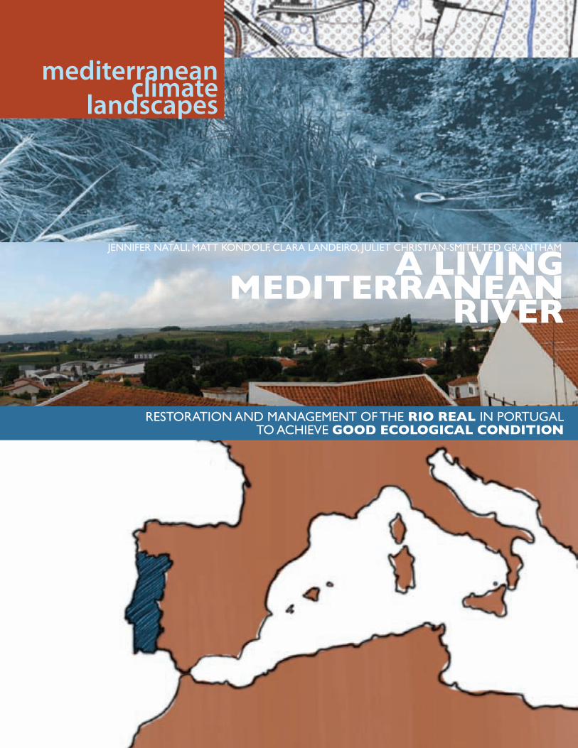
A LIVINGMEDITERRANEAN
RIVER
RestoRation and ManageMent of the RIo REAL in PoRtugalto achieve GooD EcoLoGIcAL coNDITIoN
mediterraneanclimate
landscapes
JennifeR natali, Matt Kondolf, claRa landeiRo, Juliet chRistian-sMith, ted gRanthaM
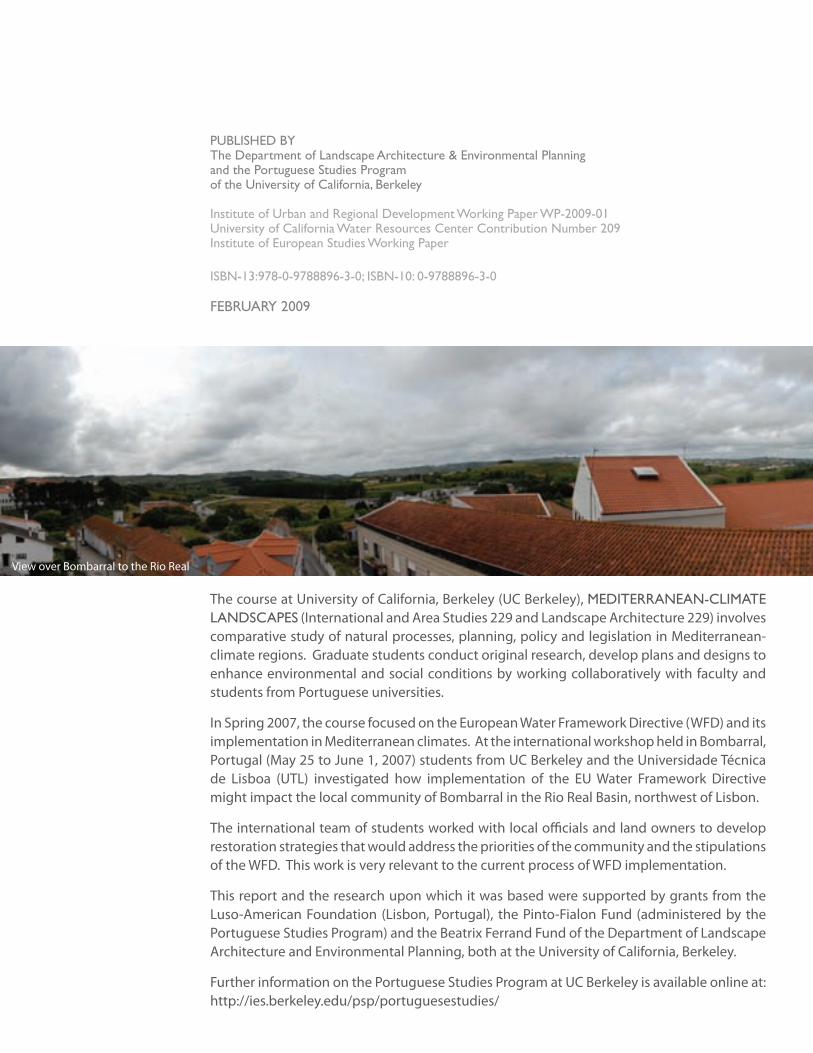
The course at University of California, Berkeley (UC Berkeley), MediteRRanean-cliMate landscaPes (International and Area Studies 229 and Landscape Architecture 229) involves comparative study of natural processes, planning, policy and legislation in Mediterranean-climate regions. Graduate students conduct original research, develop plans and designs to enhance environmental and social conditions by working collaboratively with faculty and students from Portuguese universities.
In Spring 2007, the course focused on the European Water Framework Directive (WFD) and its implementation in Mediterranean climates. At the international workshop held in Bombarral, Portugal (May 25 to June 1, 2007) students from UC Berkeley and the Universidade Técnica de Lisboa (UTL) investigated how implementation of the EU Water Framework Directive might impact the local community of Bombarral in the Rio Real Basin, northwest of Lisbon.
The international team of students worked with local officials and land owners to develop restoration strategies that would address the priorities of the community and the stipulations of the WFD. This work is very relevant to the current process of WFD implementation.
This report and the research upon which it was based were supported by grants from the Luso-American Foundation (Lisbon, Portugal), the Pinto-Fialon Fund (administered by the Portuguese Studies Program) and the Beatrix Ferrand Fund of the Department of Landscape Architecture and Environmental Planning, both at the University of California, Berkeley.
Further information on the Portuguese Studies Program at UC Berkeley is available online at: http://ies.berkeley.edu/psp/portuguesestudies/
Published bythe department of landscape architecture & environmental Planningand the Portuguese studies Programof the university of california, berkeley
institute of urban and Regional development Working Paper WP-2009-01university of california Water Resources center contribution number 209institute of european studies Working Paper
isbn-13:978-0-9788896-3-0; isbn-10: 0-9788896-3-0
febRuaRy 2009
View over Bombarral to the Rio Real
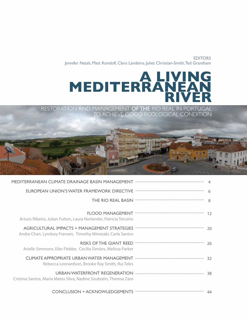
table of contentsMediteRRanean cliMate dRainage basin ManageMent
euRoPean union’s WateR fRaMeWoRK diRective
the Rio Real basin
flood ManageMentArturo Ribeiro, Julian Fulton, Laura Norlander, Patricia Terceiro
agRicultuRal iMPacts + ManageMent stRategiesAndre Chan, Lyndsey Fransen, Timothy Minezaki, Carla Santos
RisKs of the giant ReedArielle Simmons, Eike Flebbe, Cecilia Simões, Melissa Parker
cliMate aPPRoPRiate uRban WateR ManageMent Rebecca Leonardson, Brooke Ray Smith, Rui Teles
uRban WateRfRont RegeneRationCristina Santos, Maria Matos Silva, Nadine Soubotin, Theresa Zaro
conclusion + acKnoWledgeMents
4
6
8
12
20
26
32
38
44
A LIVINGMEDITERRANEAN
RIVERRestoRation and ManageMent of the Rio Real in PoRtugal
to achieve good ecological condition
editoRsJennifer natali, Matt Kondolf, clara landeiro, Juliet christian-smith, ted grantham
4
a l
ivin
g M
edit
eRR
an
ean
Riv
eR
MediteRRanean-cliMate dRainage basin ManageMent
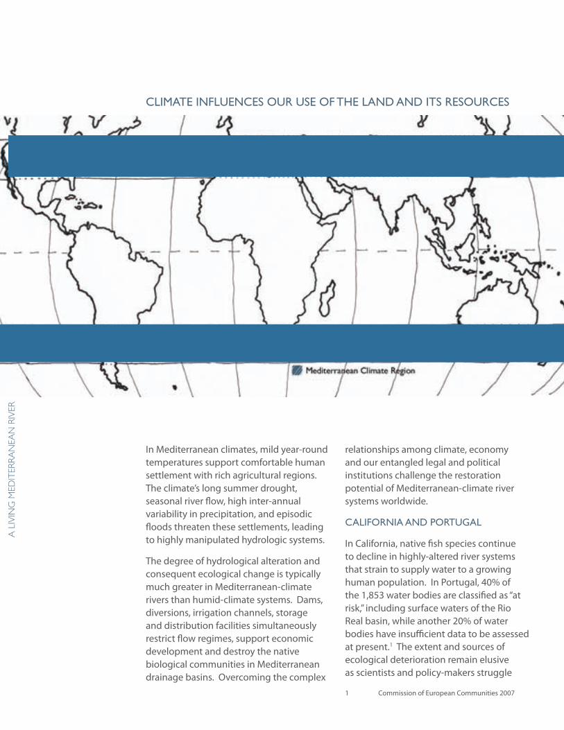
In Mediterranean climates, mild year-round temperatures support comfortable human settlement with rich agricultural regions. The climate’s long summer drought, seasonal river flow, high inter-annual variability in precipitation, and episodic floods threaten these settlements, leading to highly manipulated hydrologic systems.
The degree of hydrological alteration and consequent ecological change is typically much greater in Mediterranean-climate rivers than humid-climate systems. Dams, diversions, irrigation channels, storage and distribution facilities simultaneously restrict flow regimes, support economic development and destroy the native biological communities in Mediterranean drainage basins. Overcoming the complex
relationships among climate, economy and our entangled legal and political institutions challenge the restoration potential of Mediterranean-climate river systems worldwide.
califoRnia and PoRtugal
In California, native fish species continue to decline in highly-altered river systems that strain to supply water to a growing human population. In Portugal, 40% of the 1,853 water bodies are classified as “at risk,” including surface waters of the Rio Real basin, while another 20% of water bodies have insufficient data to be assessed at present.1 The extent and sources of ecological deterioration remain elusive as scientists and policy-makers struggle
1 Commission of European Communities 2007
cliMate influences ouR use of the land and its ResouRces
5
dePa
RtM
ent
of la
nd
sca
Pe aR
ch
itec
tu
Re a
nd
env
iRon
Men
tal Pla
nn
ing
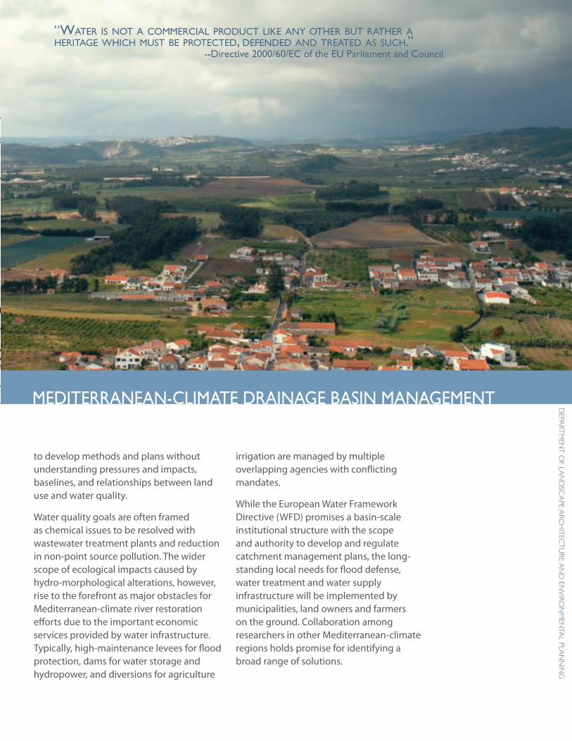
“Water is not a commercial product like any other but rather a heritage Which must be protected, defended and treated as such.”
--directive 2000/60/ec of the eu Parliament and council
to develop methods and plans without understanding pressures and impacts, baselines, and relationships between land use and water quality.
Water quality goals are often framed as chemical issues to be resolved with wastewater treatment plants and reduction in non-point source pollution. The wider scope of ecological impacts caused by hydro-morphological alterations, however, rise to the forefront as major obstacles for Mediterranean-climate river restoration efforts due to the important economic services provided by water infrastructure. Typically, high-maintenance levees for flood protection, dams for water storage and hydropower, and diversions for agriculture
irrigation are managed by multiple overlapping agencies with conflicting mandates.
While the European Water Framework Directive (WFD) promises a basin-scale institutional structure with the scope and authority to develop and regulate catchment management plans, the long-standing local needs for flood defense, water treatment and water supply infrastructure will be implemented by municipalities, land owners and farmers on the ground. Collaboration among researchers in other Mediterranean-climate regions holds promise for identifying a broad range of solutions.
MediteRRanean-cliMate dRainage basin ManageMent
6
a l
ivin
g M
edit
eRR
an
ean
Riv
eR According the River Basin Characterization reports carried out in 2004, water uses with the most significant negative impact on water status include agriculture, navigation, power generation and urban development. Urban dwellers pay most of the financial costs of water supply and waste treatment.
Photo: A new wastewater treatment plant in the Rio Real basin addresses many water quality concerns in the basin, but does not address industrial, agricultural and rural water treatment nor the overall ecological health of the drainage basin.
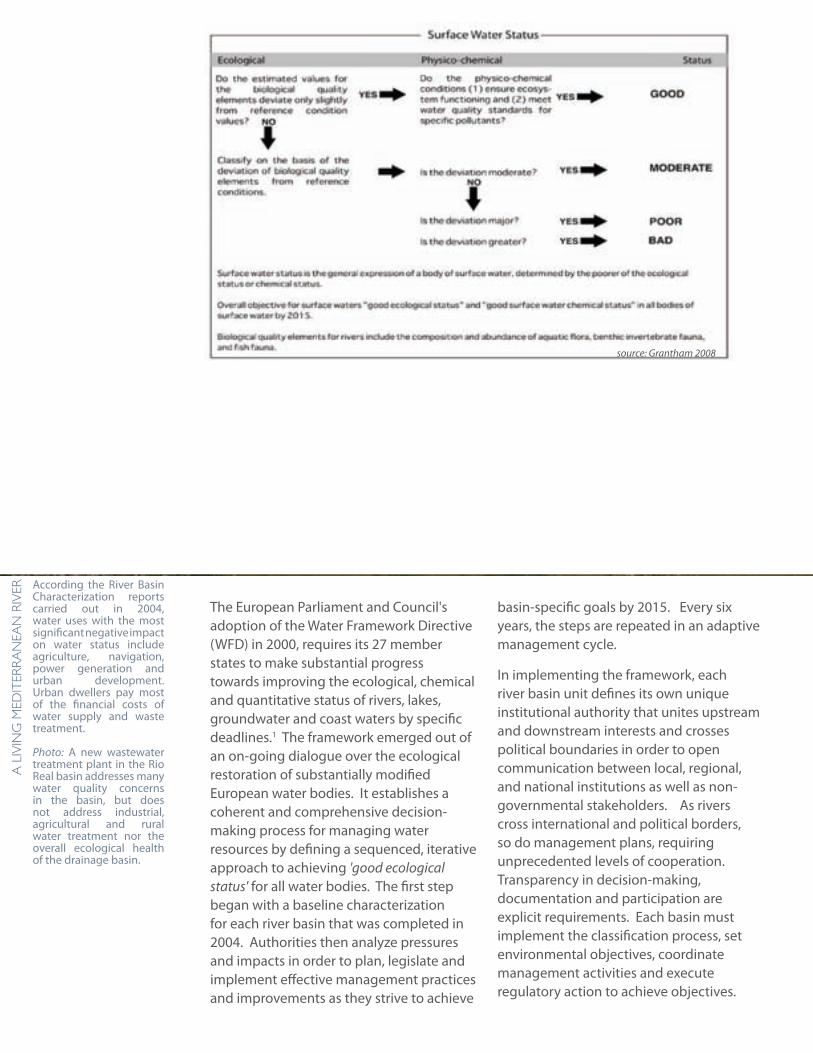
The European Parliament and Council's adoption of the Water Framework Directive (WFD) in 2000, requires its 27 member states to make substantial progress towards improving the ecological, chemical and quantitative status of rivers, lakes, groundwater and coast waters by specific deadlines.1 The framework emerged out of an on-going dialogue over the ecological restoration of substantially modified European water bodies. It establishes a coherent and comprehensive decision-making process for managing water resources by defining a sequenced, iterative approach to achieving 'good ecological status' for all water bodies. The first step began with a baseline characterization for each river basin that was completed in 2004. Authorities then analyze pressures and impacts in order to plan, legislate and implement effective management practices and improvements as they strive to achieve
basin-specific goals by 2015. Every six years, the steps are repeated in an adaptive management cycle.
In implementing the framework, each river basin unit defines its own unique institutional authority that unites upstream and downstream interests and crosses political boundaries in order to open communication between local, regional, and national institutions as well as non-governmental stakeholders. As rivers cross international and political borders, so do management plans, requiring unprecedented levels of cooperation. Transparency in decision-making, documentation and participation are explicit requirements. Each basin must implement the classification process, set environmental objectives, coordinate management activities and execute regulatory action to achieve objectives.
source: Grantham 2008
7
dePa
RtM
ent
of la
nd
sca
Pe aR
ch
itec
tu
Re a
nd
env
iRon
Men
tal Pla
nn
ing
eu WateR fRaMeWoRK diRectiveresponses to complex water management challenges faced by diverse cultures and climates. Ultimately, the WFD may help societies adapt to future environmental challenges, such as the impacts of climate change, by increasing the resilience of ecosystems and reducing the impacts of floods and water scarcity.
EU-wide, approximately 40% of surface waters are classified as "at risk" of not achieving good status by 2015. 2 The leading pressures on these water bodies is hydromorphological alteration -- changes in the natural hydrology (flow regime) and morphology (e.g. channel form, connectivity) resulting from water diversions and extraction, as well as flood defense and water supply infrastructure serving agriculture, navigation, hydropower and urban development.3
1 Scheuer 2005. EU environmental Policy Handbook pub-lished by the European Environmental Bureau 2, 3 Commission of European Communities 2007
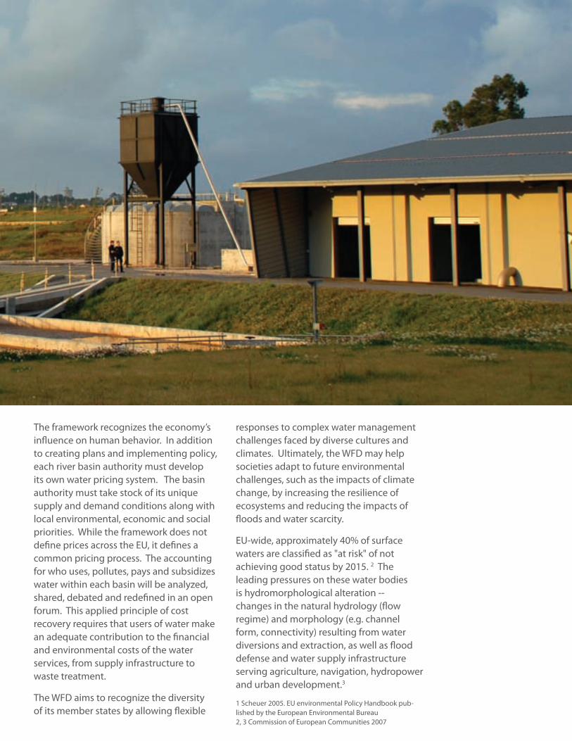
The framework recognizes the economy’s influence on human behavior. In addition to creating plans and implementing policy, each river basin authority must develop its own water pricing system. The basin authority must take stock of its unique supply and demand conditions along with local environmental, economic and social priorities. While the framework does not define prices across the EU, it defines a common pricing process. The accounting for who uses, pollutes, pays and subsidizes water within each basin will be analyzed, shared, debated and redefined in an open forum. This applied principle of cost recovery requires that users of water make an adequate contribution to the financial and environmental costs of the water services, from supply infrastructure to waste treatment.
The WFD aims to recognize the diversity of its member states by allowing flexible
8
a l
ivin
g M
edit
eRR
an
ean
Riv
eR
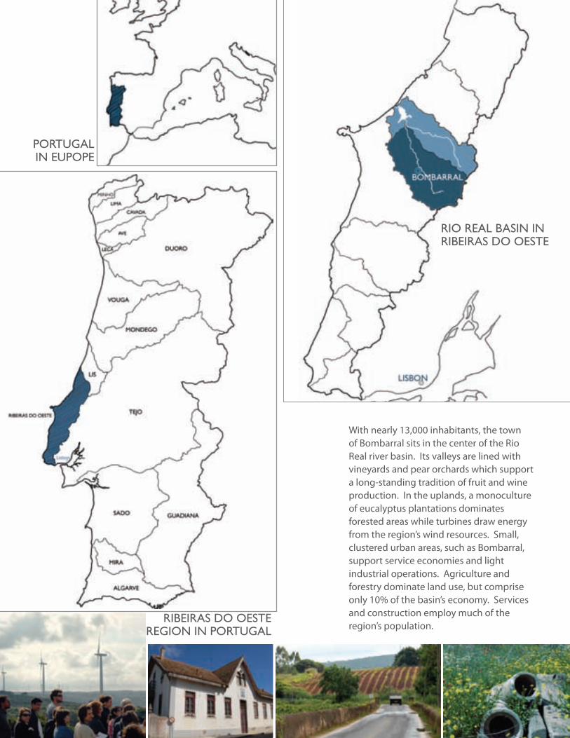
With nearly 13,000 inhabitants, the town of Bombarral sits in the center of the Rio Real river basin. Its valleys are lined with vineyards and pear orchards which support a long-standing tradition of fruit and wine production. In the uplands, a monoculture of eucalyptus plantations dominates forested areas while turbines draw energy from the region’s wind resources. Small, clustered urban areas, such as Bombarral, support service economies and light industrial operations. Agriculture and forestry dominate land use, but comprise only 10% of the basin’s economy. Services and construction employ much of the region’s population.
PoRtugal in euPoPe
RibeiRas do oeste Region in PoRtugal
Rio Real basin in RibeiRas do oeste
9
dePa
RtM
ent
of la
nd
sca
Pe aR
ch
itec
tu
Re a
nd
env
iRon
Men
tal Pla
nn
ing
hoW Will the Wfd affect a RiveR and the PeoPle Who live Within its catchMent?
WateR fRaMeWoRK diRective in boMbaRRal
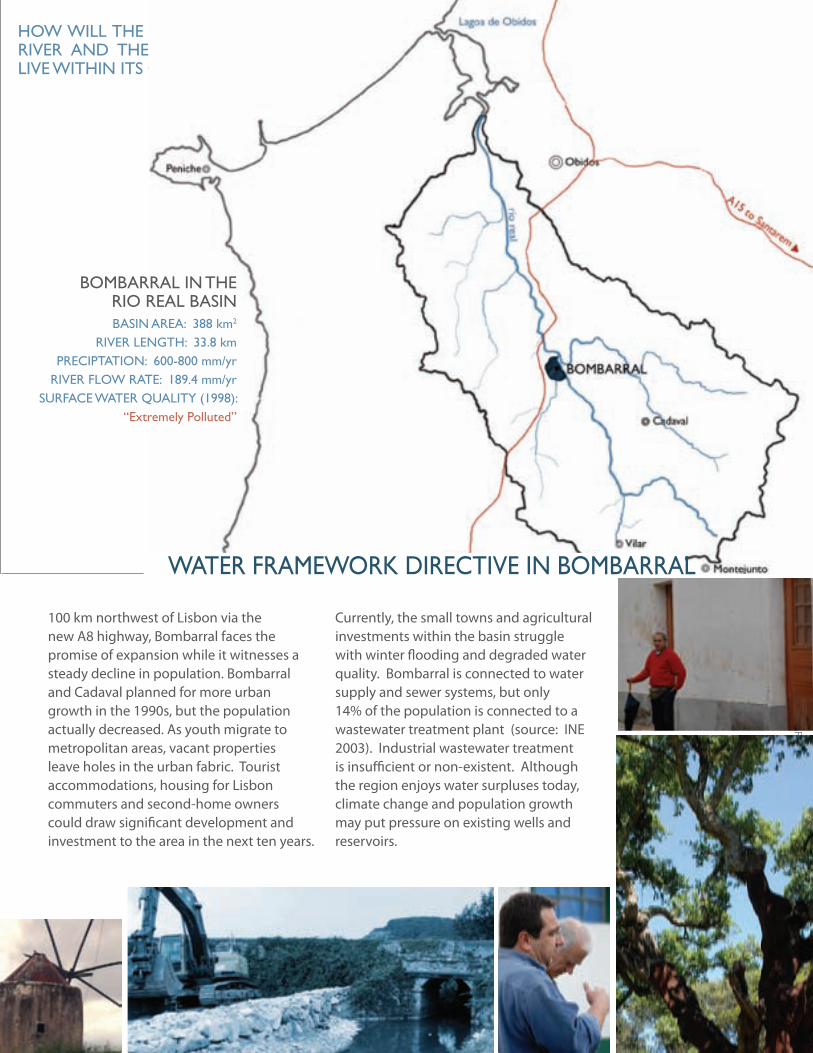
Currently, the small towns and agricultural investments within the basin struggle with winter flooding and degraded water quality. Bombarral is connected to water supply and sewer systems, but only 14% of the population is connected to a wastewater treatment plant (source: INE 2003). Industrial wastewater treatment is insufficient or non-existent. Although the region enjoys water surpluses today, climate change and population growth may put pressure on existing wells and reservoirs.
basin aRea: 388 km2
RiveR length: 33.8 kmPReciPtation: 600-800 mm/yr
RiveR floW Rate: 189.4 mm/yrsuRface WateR Quality (1998):
“extremely Polluted”
100 km northwest of Lisbon via the new A8 highway, Bombarral faces the promise of expansion while it witnesses a steady decline in population. Bombarral and Cadaval planned for more urban growth in the 1990s, but the population actually decreased. As youth migrate to metropolitan areas, vacant properties leave holes in the urban fabric. Tourist accommodations, housing for Lisbon commuters and second-home owners could draw significant development and investment to the area in the next ten years.
boMbaRRal in the Rio Real basin
10
a l
ivin
g M
edit
eRR
an
ean
Riv
eR
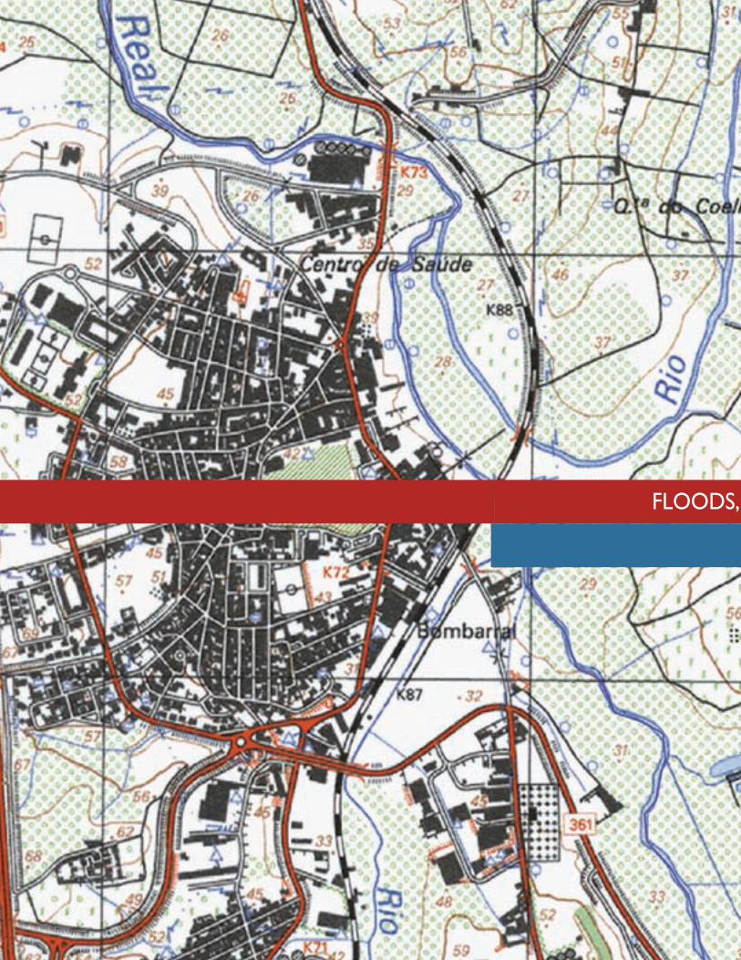
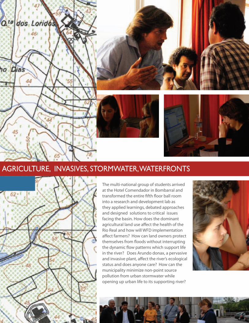
floods, agRicultuRe, invasives, stoRMWateR, WateRfRonts
11
dePa
RtM
ent
of la
nd
sca
Pe aR
ch
itec
tu
Re a
nd
env
iRon
Men
tal Pla
nn
ing
floods, agRicultuRe, invasives, stoRMWateR, WateRfRonts
The multi-national group of students arrived at the Hotel Comendador in Bombarral and transformed the entire fifth floor ball room into a research and development lab as they applied learnings, debated approaches and designed solutions to critical issues facing the basin. How does the dominant agricultural land use affect the health of the Rio Real and how will WFD implementation affect farmers? How can land owners protect themselves from floods without interrupting the dynamic flow patterns which support life in the river? Does Arundo donax, a pervasive and invasive plant, affect the river’s ecological status and does anyone care? How can the municipality minimize non-point source pollution from urban stormwater while opening up urban life to its supporting river?
12
a l
ivin
g M
edit
eRR
an
ean
Riv
eR
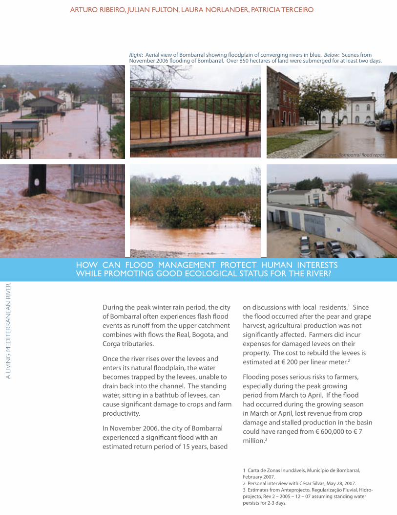
on discussions with local residents.1 Since the flood occurred after the pear and grape harvest, agricultural production was not significantly affected. Farmers did incur expenses for damaged levees on their property. The cost to rebuild the levees is estimated at € 200 per linear meter.2
Flooding poses serious risks to farmers, especially during the peak growing period from March to April. If the flood had occurred during the growing season in March or April, lost revenue from crop damage and stalled production in the basin could have ranged from € 600,000 to € 7 million.3
1 Carta de Zonas Inundáveis, Município de Bombarral, February 2007.2 Personal interview with César Silvas, May 28, 2007.3 Estimates from Anteprojecto, Regularização Fluvial, Hidro-projecto, Rev 2 – 2005 – 12 – 07 assuming standing water persists for 2-3 days.
During the peak winter rain period, the city of Bombarral often experiences flash flood events as runoff from the upper catchment combines with flows the Real, Bogota, and Corga tributaries.
Once the river rises over the levees and enters its natural floodplain, the water becomes trapped by the levees, unable to drain back into the channel. The standing water, sitting in a bathtub of levees, can cause significant damage to crops and farm productivity.
In November 2006, the city of Bombarral experienced a significant flood with an estimated return period of 15 years, based
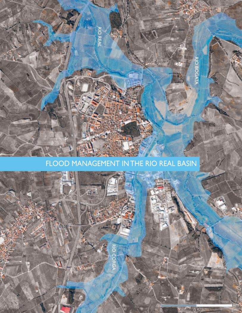
Right: Aerial view of Bombarral showing floodplain of converging rivers in blue. Below: Scenes from November 2006 flooding of Bombarral. Over 850 hectares of land were submerged for at least two days.
aRtuRo RibeiRo, Julian fulton, lauRa noRlandeR, PatRicia teRceiRo
hoW can flood ManageMent PRotect huMan inteRests While PRoMoting good ecological status foR the RiveR?
source: Bombarral flood report
13
dePa
RtM
ent
of la
nd
sca
Pe aR
ch
itec
tu
Re a
nd
env
iRon
Men
tal Pla
nn
ing
Rio
bog
ata
Rio
Rea
l
Rio
co
Rg
a
flood ManageMent in the Rio Real basin
14
a l
ivin
g M
edit
eRR
an
ean
Riv
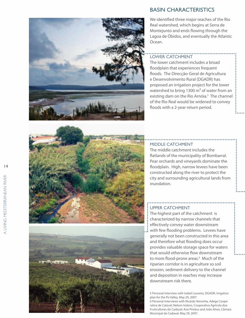
eRbasin chaRacteRistics
We identified three major reaches of the Rio Real watershed, which begins at Serra de Montejunto and ends flowing through the Lagoa de Óbidos, and eventually the Atlantic Ocean.
loWeR catchMentThe lower catchment includes a broad floodplain that experiences frequent floods. The Direcção-Geral de Agricultura e Desenvolvimento Rural (DGADR) has proposed an irrigation project for the lower watershed to bring 1300 m³ of water from an existing dam on the Rio Arnóia.5 The channel of the Rio Real would be widened to convey floods with a 2-year return period.
Middle catchMentThe middle catchment includes the flatlands of the municipality of Bombarral. Pear orchards and vineyards dominate the floodplain. High, narrow levees have been constructed along the river to protect the city and surrounding agricultural lands from inundation.
uPPeR catchMentThe highest part of the catchment is characterized by narrow channels that effectively convey water downstream with few flooding problems. Levees have generally not been constructed in this area and therefore what flooding does occur provides valuable storage space for waters that would otherwise flow downstream to more flood-prone areas.6 Much of the riparian corridor is in agriculture so soil erosion, sediment delivery to the channel and deposition in reaches may increase downstream risk there.
5 Personal interview with Isabel Loureiro, DGADR, Irrigation plan for the Po Valley, May 29, 2007.6 Personal interviews with Ricardo Noronha, Adega Coope-rativa de Cataval; Nelson Isidoro, Cooperativa Agrícola doa Fruticultores do Cadaval; Ana Pintéus and João Alves, Câmara Municipal do Cadaval, May 29, 2007.
15
dePa
RtM
ent
of la
nd
sca
Pe aR
ch
itec
tu
Re a
nd
env
iRon
Men
tal Pla
nn
ing
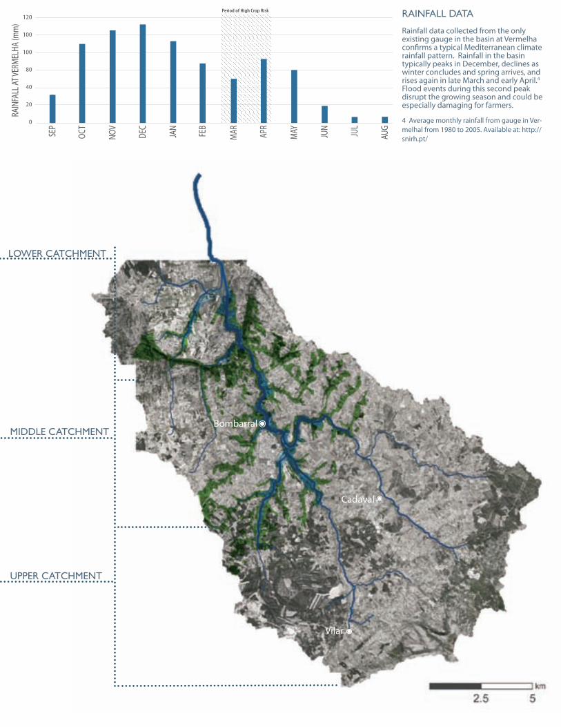
Rainfall data
Rainfall data collected from the only existing gauge in the basin at Vermelha confirms a typical Mediterranean climate rainfall pattern. Rainfall in the basin typically peaks in December, declines as winter concludes and spring arrives, and rises again in late March and early April.4 Flood events during this second peak disrupt the growing season and could be especially damaging for farmers.
4 Average monthly rainfall from gauge in Ver-melhal from 1980 to 2005. Available at: http://snirh.pt/
loWeR catchMent
uPPeR catchMent
Middle catchMent
Period of High Crop Risk
SEP
OCT
NOV
DEC
JAN
FEB
MAR AP
R
MAY JUN
JUL
AUG
RAIN
FALL
AT VE
RMEL
HA (m
m)
120
100
100
80
40
20
0
Bombarral
Cadaval
Vilar
16
a l
ivin
g M
edit
eRR
an
ean
Riv
eR
disadvantages of existing flood contRol stRuctuRes
In addition to capital and maintenance costs of levees, disadvantages of highly-engineered, constricting and intensive flood control structures include:
ISSUE ExplanatIonfalse sense of secuRity
Levees can and will fail, often during the most dangerous and damaging floods. Nevertheless, the presence of levees often encourages development and crop cultivation in the floodplain, putting buildings, crops, and people at risk.
cRoP daMage fRoM bathtub effect
Levees can trap and store water on farmland. Although agriculture in the Rio Real basin is able to withstand limited periods of standing water, levees can prolong inundation periods and cause lost productivity and significant crop damage.
incReased eRosion and sediMent scouR
Confining river flows to a channel will increase channel scouring, causing the bed to incise. This can lower the floodplain water table and undermine bridges and other structures.
disRuPted sediMent tRansPoRt
Levees eliminate the natural function of rivers to transport and spread sediment and nutrients throughout the floodplain.
degRaded Wildlife habitat
Plants and animals dependant on a riparian corridor are limited to a simplified, narrow strip of vegetation within the levee system.
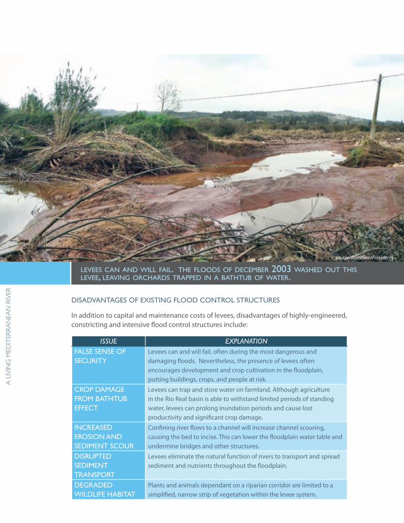
levees can and Will fail. the floods of december 2003 Washed out this levee, leaving orchards trapped in a bathtub of Water.
source: Bombarral residents
17
dePa
RtM
ent
of la
nd
sca
Pe aR
ch
itec
tu
Re a
nd
env
iRon
Men
tal Pla
nn
ing
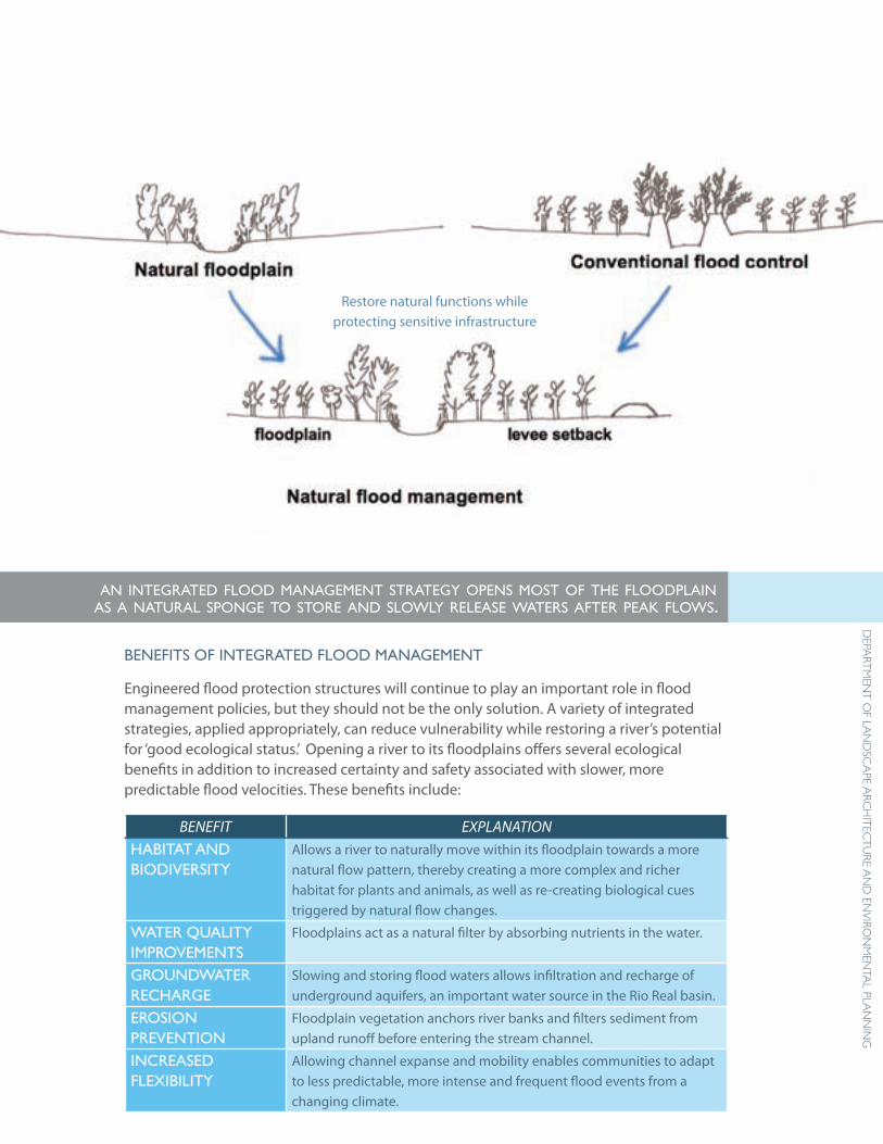
benefits of integRated flood ManageMent
Engineered flood protection structures will continue to play an important role in flood management policies, but they should not be the only solution. A variety of integrated strategies, applied appropriately, can reduce vulnerability while restoring a river’s potential for ‘good ecological status.’ Opening a river to its floodplains offers several ecological benefits in addition to increased certainty and safety associated with slower, more predictable flood velocities. These benefits include:
BENEFIT EXPLANATIONhabitat and biodiveRsity
Allows a river to naturally move within its floodplain towards a more natural flow pattern, thereby creating a more complex and richer habitat for plants and animals, as well as re-creating biological cues triggered by natural flow changes.
WateR Quality iMPRoveMents
Floodplains act as a natural filter by absorbing nutrients in the water.
gRoundWateR RechaRge
Slowing and storing flood waters allows infiltration and recharge of underground aquifers, an important water source in the Rio Real basin.
eRosion PRevention
Floodplain vegetation anchors river banks and filters sediment from upland runoff before entering the stream channel.
incReased flexibility
Allowing channel expanse and mobility enables communities to adapt to less predictable, more intense and frequent flood events from a changing climate.
an integrated flood management strategy opens most of the floodplain as a natural sponge to store and sloWly release Waters after peak floWs.
Restore natural functions while protecting sensitive infrastructure
18
a l
ivin
g M
edit
eRR
an
ean
Riv
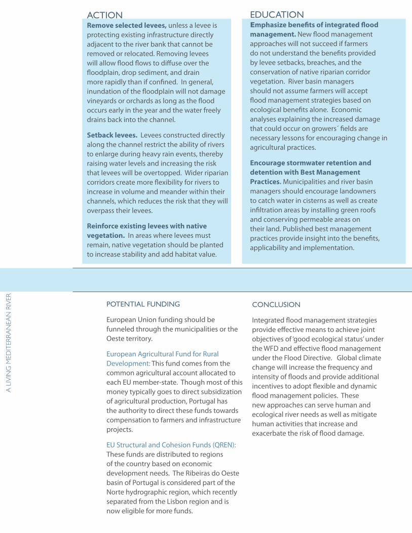
eRaction Remove selected levees, unless a levee is protecting existing infrastructure directly adjacent to the river bank that cannot be removed or relocated. Removing levees will allow flood flows to diffuse over the floodplain, drop sediment, and drain more rapidly than if confined. In general, inundation of the floodplain will not damage vineyards or orchards as long as the flood occurs early in the year and the water freely drains back into the channel.
Setback levees. Levees constructed directly along the channel restrict the ability of rivers to enlarge during heavy rain events, thereby raising water levels and increasing the risk that levees will be overtopped. Wider riparian corridors create more flexibility for rivers to increase in volume and meander within their channels, which reduces the risk that they will overpass their levees.
Reinforce existing levees with native vegetation. In areas where levees must remain, native vegetation should be planted to increase stability and add habitat value.
RecoMMendations foR integRated flood ManageMent
educationEmphasize benefits of integrated flood management. New flood management approaches will not succeed if farmers do not understand the benefits provided by levee setbacks, breaches, and the conservation of native riparian corridor vegetation. River basin managers should not assume farmers will accept flood management strategies based on ecological benefits alone. Economic analyses explaining the increased damage that could occur on growers´ fields are necessary lessons for encouraging change in agricultural practices.
Encourage stormwater retention and detention with Best Management Practices. Municipalities and river basin managers should encourage landowners to catch water in cisterns as well as create infiltration areas by installing green roofs and conserving permeable areas on their land. Published best management practices provide insight into the benefits, applicability and implementation.
Potential funding
European Union funding should be funneled through the municipalities or the Oeste territory.
European Agricultural Fund for Rural Development: This fund comes from the common agricultural account allocated to each EU member-state. Though most of this money typically goes to direct subsidization of agricultural production, Portugal has the authority to direct these funds towards compensation to farmers and infrastructure projects.
EU Structural and Cohesion Funds (QREN): These funds are distributed to regions of the country based on economic development needs. The Ribeiras do Oeste basin of Portugal is considered part of the Norte hydrographic region, which recently separated from the Lisbon region and is now eligible for more funds.
conclusion
Integrated flood management strategies provide effective means to achieve joint objectives of ‘good ecological status’ under the WFD and effective flood management under the Flood Directive. Global climate change will increase the frequency and intensity of floods and provide additional incentives to adopt flexible and dynamic flood management policies. These new approaches can serve human and ecological river needs as well as mitigate human activities that increase and exacerbate the risk of flood damage.
19
dePa
RtM
ent
of la
nd
sca
Pe aR
ch
itec
tu
Re a
nd
env
iRon
Men
tal Pla
nn
ing
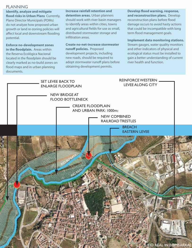
SET LEVEE BACK TOENLARGE FLOODPLAIN
NEW BRIDGE ATFLOOD BOTTLENECK
CREATE FLOODPLAINAND URBAN PARK: 1000m2
NEW COMBINEDRAILROAD TRESTLES
BREACHEASTERN LEVEE
REINFORCE WESTERNLEVEE ALONG CITY
BOMBARRAL FLOOD MANAGEMENT RECOMMENDATIONS
Planning Identify, analyze and mitigate flood risks in Urban Plans Currently, Plano Director Municipals (PDMs) do not analyze how proposed urban growth or land re-zoning policies will affect local and downstream flooding potential.
Enforce no-development zones in the floodplain. Areas within the Reserva Ecológica Nacional located in the floodplain should be clearly marked as no-build zones on flood maps and in urban planning documents.
Increase rainfall retention and detention areas. Urban planners should work with river basin managers to identify areas within cities, towns and agricultural fields for use as small, distributed stormwater storage and infiltration areas.
Create no-net-increase stormwater runoff policies. Proposed development projects, including new roads, should be required to adopt stormwater runoff plans before obtaining development permits.
Develop flood warning, response, and reconstruction plans. Develop reconstruction plans before flood damage occurs to avoid hasty actions that could be incompatible with long term flood management goals.
Implement data monitoring stations. Stream gauges, water quality monitors and other indicators of physical and ecological status must be installed to gain a better understanding of current river health and function.
Rio bogata
Rio Real
Rio Real in boMbaRRal
20
a l
ivin
g M
edit
eRR
an
ean
Riv
eR
groundwater sources with each intense rainfall event. Moreover, a breach in the lining of the landfill could result in catastrophic pollution of the entire aquifer.
Contamination is not the only issue. At the current rate of groundwater extraction, the aquifer appears insufficient for future needs. Above-ground water sources also prove unpredictable, despite appearances of plenty. Only the artificial inputs from sewer outfalls keep river beds wet during summer months.
The effects of climate change must also influence water resource planning. Introducing economic incentives to conserve water use as well as encourage better flood management will be of major importance in maintaining the social and economic viability of the region.
54%
9%
24%
12%
NaturalVegetation
Forest
Urban
Agriculture
Industrial <1%Water Bodies <1%
LAND USE IN RIO REAL BASIN
Greenhouses <1%Other Agriculture 2%
AGRICULTURAL LAND USE
43%Polyculture
48%
Orchards,Vineyards,+ Olives
Lo-LyingAlluvial
6%
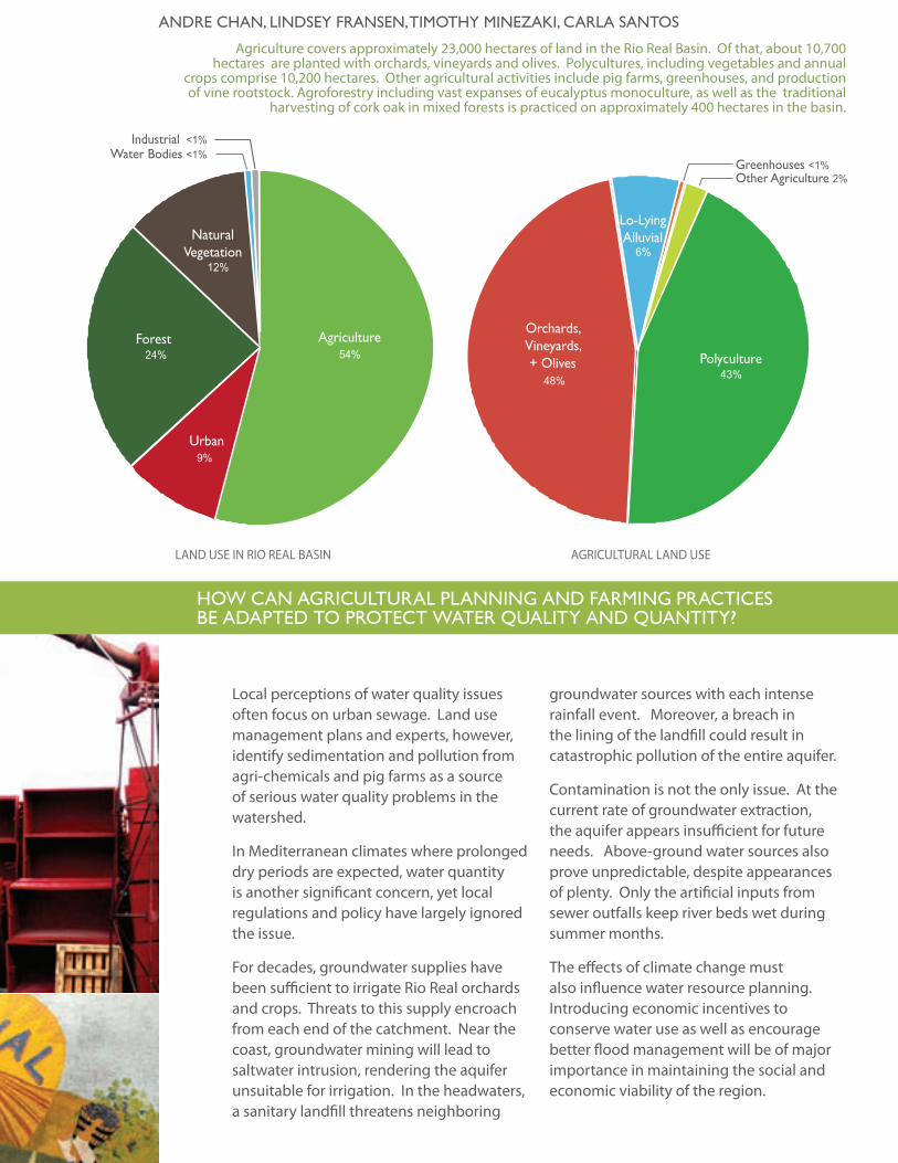
Agriculture covers approximately 23,000 hectares of land in the Rio Real Basin. Of that, about 10,700 hectares are planted with orchards, vineyards and olives. Polycultures, including vegetables and annual
crops comprise 10,200 hectares. Other agricultural activities include pig farms, greenhouses, and production of vine rootstock. Agroforestry including vast expanses of eucalyptus monoculture, as well as the traditional
harvesting of cork oak in mixed forests is practiced on approximately 400 hectares in the basin.
Local perceptions of water quality issues often focus on urban sewage. Land use management plans and experts, however, identify sedimentation and pollution from agri-chemicals and pig farms as a source of serious water quality problems in the watershed.
In Mediterranean climates where prolonged dry periods are expected, water quantity is another significant concern, yet local regulations and policy have largely ignored the issue.
For decades, groundwater supplies have been sufficient to irrigate Rio Real orchards and crops. Threats to this supply encroach from each end of the catchment. Near the coast, groundwater mining will lead to saltwater intrusion, rendering the aquifer unsuitable for irrigation. In the headwaters, a sanitary landfill threatens neighboring
andRe chan, lindsey fRansen, tiMothy MinezaKi, caRla santos
hoW can agRicultuRal Planning and faRMing PRactices be adaPted to PRotect WateR Quality and Quantity? agRicultuRal iMPacts + ManageMent stRategies
21
dePa
RtM
ent
of la
nd
sca
Pe aR
ch
itec
tu
Re a
nd
env
iRon
Men
tal Pla
nn
ing
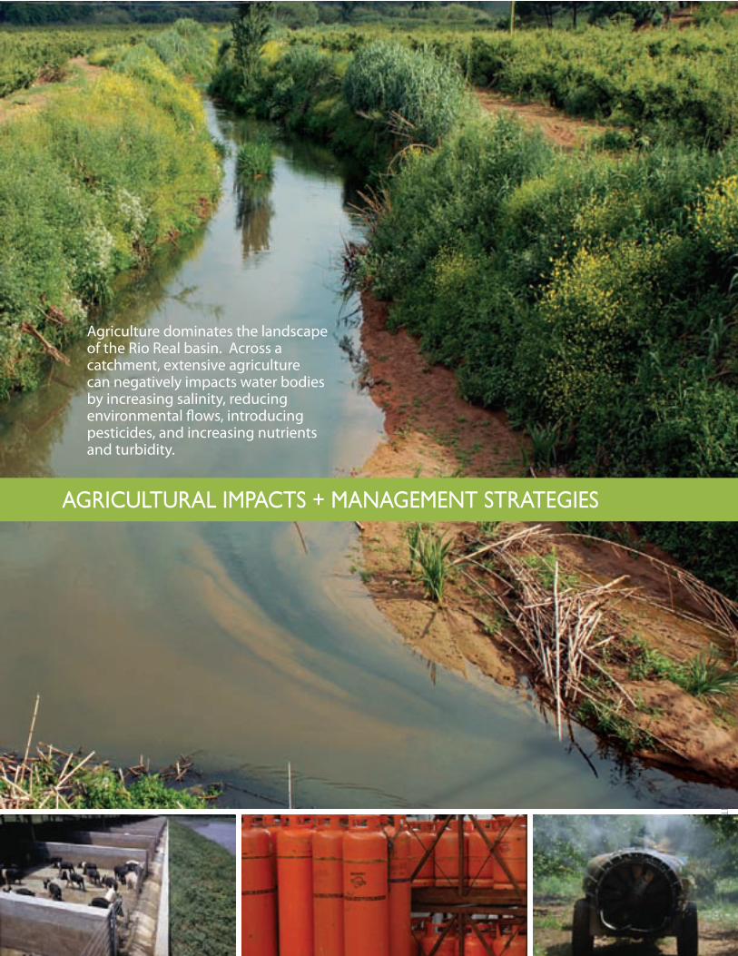
Agriculture dominates the landscape of the Rio Real basin. Across a catchment, extensive agriculture can negatively impacts water bodies by increasing salinity, reducing environmental flows, introducing pesticides, and increasing nutrients and turbidity.
agRicultuRal iMPacts + ManageMent stRategies
22
a l
ivin
g M
edit
eRR
an
ean
Riv
eR
stReaM setbacKs & RiPaRian buffeRs
A stream setback prohibits development or disturbance within a certain distance from the river in order to reduce erosion of the banks and establish a valuable riparian buffer. Swaths of native riparian vegetation not only stabilize the banks, but can also lower water temperature by shading the river, creating habitat for aquatic and riparian organisms and providing a bio-filter for stormwater runoff.
Stream setbacks can also decrease crop damage during floods. By removing levees to create a riparian buffer, properties between the levee and channel will experience more frequent floods, but over the long term, the risk of flood damage decreases as the buffer provides faster, more effective drainage for flood waters to recede. Most of the crops grown in the Rio Real watershed can withstand flooding, as
long as the water only remains for one to three days. The ‘bathtub effect’ created by levees trapping water in agriculture fields creates extensive and costly crop damage. Trapped floodwaters generate high clean up costs for farmers, ranging from water pumping to sediment removal.
Currently, Portugal’s Dereito-Lei 46/94 states that all land within 10-meters of a river is part of Portugal’s ‘public domain’ and is automatically required to function as a riparian setback zone. This regulation appears to be a ‘paper law’ and is not well-enforced. A more stringent application of this law could greatly benefit Rio Real farmers and improve Bombarral’s compliance with the ecological parameters of the WFD. Furthermore, by planting native vegetation with the 10-meter riparian setback, farmers have potential to receive payments for carbon sequestration under the Kyoto Protocol. With a 10-meter
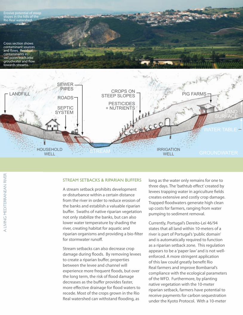
LANDFILL
SEPTICSYSTEM
CROPS ONSTEEP SLOPES
PESTICIDES+ NUTRIENTS
ROADS
SEWERPIPES
PIG FARMS
HOUSEHOLDWELL
STREAM IRRIGATIONWELL GROUNDWATER
WATER TABLE
LANDSURFACE
Sources of Surface and Ground Water Contamination
Cross section shows contaminant sources and flows. Residual contaminants in soil pores leach into groudwater and flow towards streams.
Erosive potential of steep slopes in the hills of the Rio Real watershed.
“a 2ha forest along stream setbacks in the basin could sequester 6 tons of carbon, help stop global Warming, and earn farmers 9,000 euros annually.”
23
dePa
RtM
ent
of la
nd
sca
Pe aR
ch
itec
tu
Re a
nd
env
iRon
Men
tal Pla
nn
ing
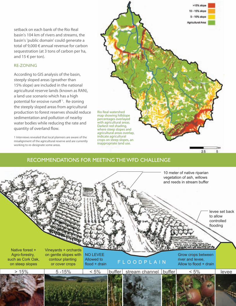
> 15% 5 -15% < 5% stream channel bufferbuffer < 5% levee
levee set backto allowcontrolledflooding
Grow crops betweenriver and levee,Allow to flood + drain
10 meter of native riparian vegetation of ash, willows and reeds in stream buffer
NO LEVEEAllowed to flood + drain
Vineyards + orchardson gentle slopes with
contour planting or cover crops
Native forest +Agro-forestry,
such as Cork Oak,on steep slopes F L O O D P L A I N
RecoMMendations foR Meeting the Wfd challenge
Rio Real watershed map showing hillslope percentages overlayed with agricultural areas. Darkest red shading, where steep slopes and agricultural areas overlap, indicate agricultural crops on steep slopes, an inappropriate land use.
setback on each bank of the Rio Real basin's 104 km of rivers and streams, the basin's 'public domain' could generate a total of 9,000 € annual revenue for carbon sequestration (at 3 tons of carbon per ha, and 15 € per ton).
Re-zoning
According to GIS analysis of the basin, steeply sloped areas (greather than 15% slope) are included in the national agricultural reserve lands (known as RAN), a land use scenario which has a high potential for erosive runoff 1. Re-zoning the steeply sloped areas from agricultural production to forest reserves should reduce sedimentation and pollution of nearby water bodies while reducing the rate and quantity of overland flow.
1 Interviews revealed that local planners are aware of the misalignment of the agricultural reserve and are currently working to re-designate some areas.
24
a l
ivin
g M
edit
eRR
an
ean
Riv
eR
eu MaRKet incentives
Incentives to promote sustainable agricultural practices within the Rio Real basin include sustainable opportunities within the EU market. For example, one major source of funding for environmentally sustainable agriculture is the EU Common Agricultural Policy (CAP). Under this framework, farmers can apply for funding from a myriad of programs (i.e. AGRO, AGRIS, etc) for rural development projects, such as eco-tourism or organic farming. Some programs of particular significance for the Rio Real basin are the EAGGF, which allows for early retirement; and another new CAP program which discourages planting invasive eucalyptus through subsidizing land use alternatives.
integRated PRoduction
Agricultural management practices can lower the quantities of pollutants present in runoff. Farmer associations, such as APAS, encourage “Integrated Production” practices, which promote lower chemical and fertilizer use. APAS guidelines closely align with EurepGAP, a certification system for ensuring the quality of EU food exports. Overall, EurepGAP standards are more environmentally friendly than many conventional agricultural practices, and they allow farmers access to a larger market share than if they were out of compliance.
coveR cRoPs
With technical and financial support, planting practices can reduce erosion and stormwater runoff. Planting orchards and vineyards in line with slope contours helps reduce erosive potential of soils, but can create hazards for equipment use in mechanized agriculture. Planting cover crops between rows is a feasible alternative that not only helps to hold soil in place, but also increases infiltration, thereby recharging groundwater.
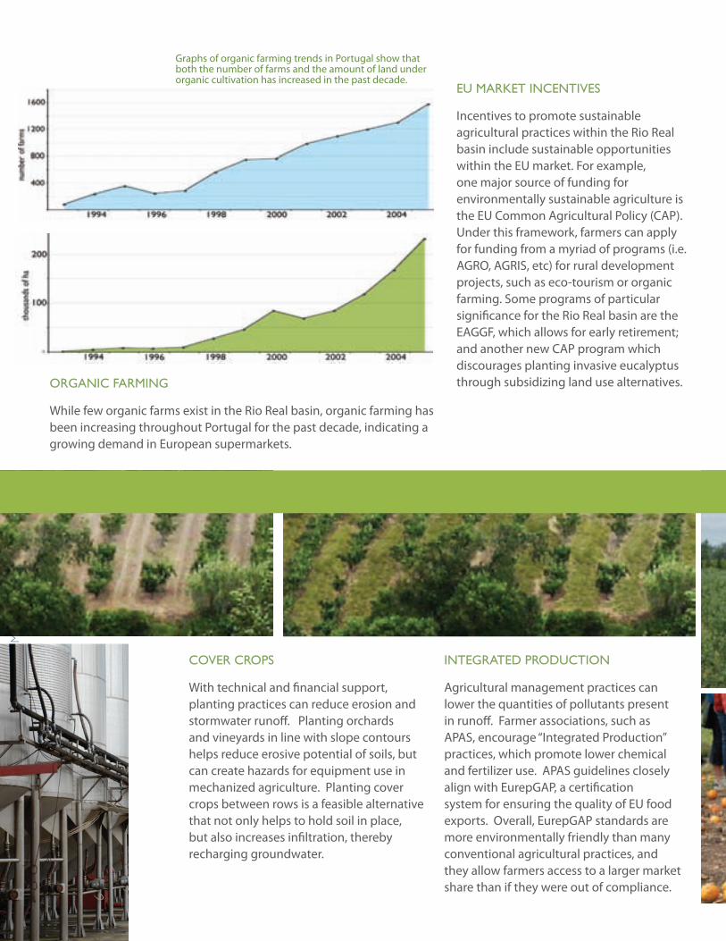
oRganic faRMing
While few organic farms exist in the Rio Real basin, organic farming has been increasing throughout Portugal for the past decade, indicating a growing demand in European supermarkets.
Graphs of organic farming trends in Portugal show that both the number of farms and the amount of land under organic cultivation has increased in the past decade.
25
dePa
RtM
ent
of la
nd
sca
Pe aR
ch
itec
tu
Re a
nd
env
iRon
Men
tal Pla
nn
ing
conclusion
The global market economy and the lack of enforced land use legislation have led to unsustainable agricultural practices in the Rio Real basin. Globalization has had a well-docmented effect on lowering prices for agricultural products and reducing farmer income all across the world. As a result many farmers, especially in small agricultural communities like Bombarral, are resorting to cheap “unsustainable” farming practices or leaving agriculture for more lucrative employment opportunities.
Unfortunately, typical uses of abandoned agricultural land include: 1) urban development, which is a threat to the rural landscape and culture of the area, and 2) planting eucalyptus, a non-native species which competes with native plants, changes soil chemistry, and presents a fire hazard.
The second impetus for unsustainable agriculture practices is the lack of enforcement of regulation. As this case study demonstrates, even though regulations encouraging good agricultural and land use practices exist, they are not enforced and not followed, which furthers the degradation of the region’s land and the water resources. The EU Water Framework Directive may have a positive impact on agricultural practices only if the directive is applied and enforced in cooperation with local authorities and landowners.
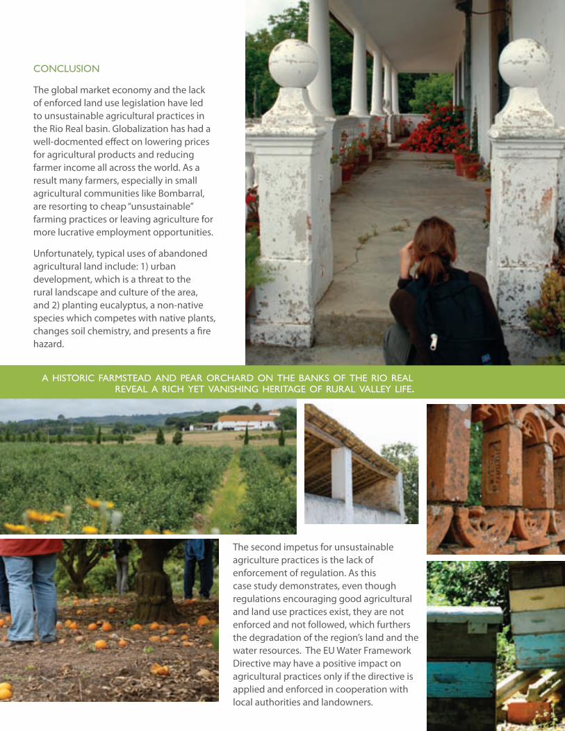
a historic farmstead and pear orchard on the banks of the rio real reveal a rich yet vanishing heritage of rural valley life.
26
a l
ivin
g M
edit
eRR
an
ean
Riv
eRaRielle siMMons, cecilia siMÕes, eiKe flebbe, Melissa PaRKeR
The Giant Reed (Arundo donax) is an invasive riparian species which has been aggressively encroaching on Portuguese channels and floodplains for decades. The catchment-wide impacts generated by Arundo make it a candidate species for removal under the European Union’s Water Framework Directive (WFD). In Bombarral, we determined the degree of Arundo spread in the riparian system and then defined strategies for removing Arundo in order to further Portugal’s compliance with the ecological objectives of the WFD.
bacKgRound
The Giant Reed is classified as a perennial hydrophyte, which ranges from 2 to 9 meters tall and grows in cane-like clumps that frequently transform into large
infestation colonies. The plant is a member of the Poacea (grass) family and closely resembles bamboo with its stout hollow culms that range 1 to 4 cm (0.5 to 1.5 in) thick and its shallow rooting system. Due to its intolerance for freezing, the plant is typically found in elevations below 304 meters (1,000 ft) and along the margins of low-gradient riparian streams. Reproducing asexually through the distribution of rhizome and stem particles, Arundo uses its close proximity to water sources to transport and spread its reproductive matter downstream.
Arundo donax has long been acknowledged as a nemesis within Mediterranean climates. The natural flood regimes of Mediterranean streams coupled with anthropogenic disturbances such as the
27
dePa
RtM
ent
of la
nd
sca
Pe aR
ch
itec
tu
Re a
nd
env
iRon
Men
tal Pla
nn
ing
giant RisK of the giant Reed
sPRead via flashy and sPoRadic MediteRRanean flood events, aRundo decReases sPecies diveRsity, incReases flood and fiRe RisK, and iMPaiRs WateR Quality and Quantity.
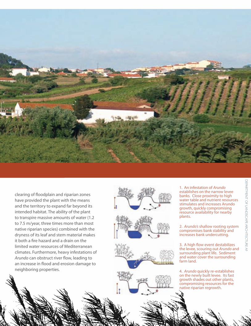
clearing of floodplain and riparian zones have provided the plant with the means and the territory to expand far beyond its intended habitat. The ability of the plant to transpire massive amounts of water (1.2 to 7.5 m/year, three times more than most native riparian species) combined with the dryness of its leaf and stem material makes it both a fire hazard and a drain on the limited water resources of Mediterranean climates. Furthermore, heavy infestations of Arundo can obstruct river flow, leading to an increase in flood and erosion damage to neighboring properties.
1. An infestation of Arundo establishes on the narrow levee banks. Close proximity to high water table and nutrient resources stimulates and increases Arundo growth, quickly compromising resource availability for nearby plants.
2. Arundo’s shallow rooting system compromises bank stability and increases bank undercutting.
3. A high flow event destabilizes the levee, scouring out Arundo and surrounding plant life. Sediment and water cover the surrounding farm land.
4. Arundo quickly re-establishes on the newly built levee. Its fast growth shades out other plants, compromising resources for the native riparian regrowth.
28
a l
ivin
g M
edit
eRR
an
ean
Riv
eRMethods
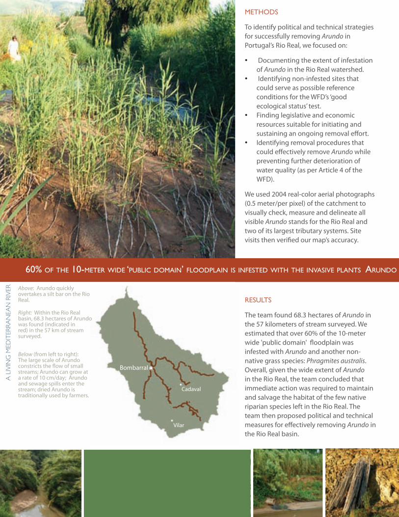
To identify political and technical strategies for successfully removing Arundo in Portugal’s Rio Real, we focused on:
Documenting the extent of infestation •of Arundo in the Rio Real watershed. Identifying non-infested sites that •could serve as possible reference conditions for the WFD’s ‘good ecological status’ test. Finding legislative and economic •resources suitable for initiating and sustaining an ongoing removal effort. Identifying removal procedures that •could effectively remove Arundo while preventing further deterioration of water quality (as per Article 4 of the WFD).
We used 2004 real-color aerial photographs (0.5 meter/per pixel) of the catchment to visually check, measure and delineate all visible Arundo stands for the Rio Real and two of its largest tributary systems. Site visits then verified our map’s accuracy.
Results
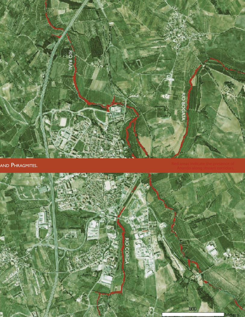
The team found 68.3 hectares of Arundo in the 57 kilometers of stream surveyed. We estimated that over 60% of the 10-meter wide 'public domain' floodplain was infested with Arundo and another non-native grass species: Phragmites australis. Overall, given the wide extent of Arundo in the Rio Real, the team concluded that immediate action was required to maintain and salvage the habitat of the few native riparian species left in the Rio Real. The team then proposed political and technical measures for effectively removing Arundo in the Rio Real basin.
Above: Arundo quickly overtakes a silt bar on the Rio Real.
Right: Within the Rio Real basin, 68.3 hectares of Arundo was found (indicated in red) in the 57 km of stream surveyed.
Below (from left to right): The large scale of Arundo constricts the flow of small streams; Arundo can grow at a rate of 10 cm/day; Arundo and sewage spills enter the stream; dried Arundo is traditionally used by farmers.
60% of the 10-meter Wide ‘public domain’ floodplain is infested With the invasive plants arundo and phragmites.
Bombarral
Cadaval
Vilar
29
dePa
RtM
ent
of la
nd
sca
Pe aR
ch
itec
tu
Re a
nd
env
iRon
Men
tal Pla
nn
ing
Rio
bog
ata
Rio
Rea
l
Rio
co
Rg
a
Red areas indicate the presence of Arundo along stream corridors.60% of the 10-meter Wide ‘public domain’ floodplain is infested With the invasive plants arundo and phragmites.
30
a l
ivin
g M
edit
eRR
an
ean
Riv
eRin the Rio Real compromises the river’s morphological quality and ability to pass the WFD’s good ecological status test.
The WFD is not the only decree which can be applied towards the effort to remove Arundo in the Rio Real. In 1994, Deceito-Lei 46/94 (amended to Decreito-Lei 234 in 1998) obligated the Ministério do Ambiente do Ordenamento do Território e do Desenvolvimento Regional (MAOTDR) to ensure that streams were “clean and unblocked.” Given Arundo’s propensity to encroach into stream channels and constrain river flow, Arundo removal falls under the direct jurisdiction of MAOTDR and its affiliated agencies. Furthermore, Decreito-Lei 565/99 regulates the introduction of non-native species and directly identifies Arundo as an invasive species whose growth should be prohibited and curtailed by MAOTDR. These two legislative decrees define the jurisdiction of Arundo removal on a national and regional level. These decrees were heavily cited during Portugal’s widespread effort to remove the floating invasive Jacinto aquático (water hyathica) from shipping and irrigation channels. The widespread reduction of Jacinto since the late 90’s attests to the possibility of applying the same legislation to Arundo removal in Portugal.
technical MeasuRes
To successfully restore the Rio Real’s native riparian corridor, the group determined that a great deal of Arundo would have to be removed and permanently eradicated from the Rio Real’s floodplains. As a result, the group outlined a plausible Arundo removal and riparian restoration strategy based on the plant’s growth and spread characteristics.
Because of the plant’s dispersal method (i.e. downstream distribution of reproductive material during flood events), removal
Political MeasuRes
The WFD provides the necessary motivational framework for instigating and enforcing Arundo removal in the Rio Real. Even though the WFD doesn’t directly mention invasive species as a specific interest for water body health, the importance of Arundo removal is implied in Annex 5 Table 1.2 where “high status” rivers are noted as having “riparian zones [which] correspond totally or nearly totally to undisturbed conditions.” Since Arundo is a non-native invasive species which thrives upon and creates disturbance in the riparian corridor, the presence of Arundo
Uses for harvested and dried Arundo include crafts such
as woven baskets or musical instruments, light structural roofs and trellises, mulch for
orchards, or creative streambank interventions.
high status zone of remnant riparian forest
31
dePa
RtM
ent
of la
nd
sca
Pe aR
ch
itec
tu
Re a
nd
env
iRon
Men
tal Pla
nn
ing
Arundo growth justifies expensive and time intensive removal efforts. Therefore, future research efforts should focus on affordable removal techniques, efficient ways to educate and involve the public, and plausible funding sources (i.e. carbon sequestration subsidies for native riparian corridors, wildlife habitat funds, land improvement grants, etc.).
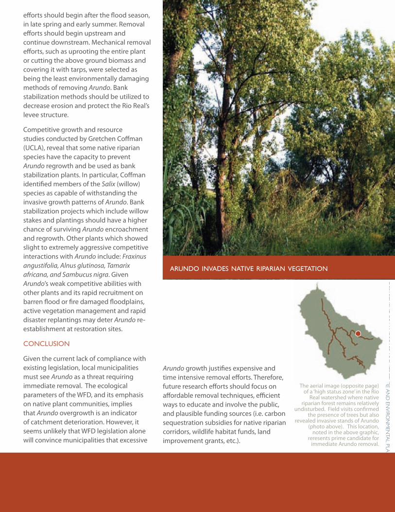
efforts should begin after the flood season, in late spring and early summer. Removal efforts should begin upstream and continue downstream. Mechanical removal efforts, such as uprooting the entire plant or cutting the above ground biomass and covering it with tarps, were selected as being the least environmentally damaging methods of removing Arundo. Bank stabilization methods should be utilized to decrease erosion and protect the Rio Real’s levee structure.
Competitive growth and resource studies conducted by Gretchen Coffman (UCLA), reveal that some native riparian species have the capacity to prevent Arundo regrowth and be used as bank stabilization plants. In particular, Coffman identified members of the Salix (willow) species as capable of withstanding the invasive growth patterns of Arundo. Bank stabilization projects which include willow stakes and plantings should have a higher chance of surviving Arundo encroachment and regrowth. Other plants which showed slight to extremely aggressive competitive interactions with Arundo include: Fraxinus angustifolia, Alnus glutinosa, Tamarix africana, and Sambucus nigra. Given Arundo’s weak competitive abilities with other plants and its rapid recruitment on barren flood or fire damaged floodplains, active vegetation management and rapid disaster replantings may deter Arundo re-establishment at restoration sites.
conclusion
Given the current lack of compliance with existing legislation, local municipalities must see Arundo as a threat requiring immediate removal. The ecological parameters of the WFD, and its emphasis on native plant communities, implies that Arundo overgrowth is an indicator of catchment deterioration. However, it seems unlikely that WFD legislation alone will convince municipalities that excessive
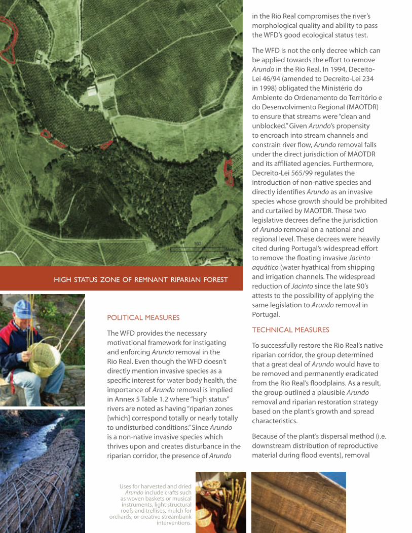
The aerial image (opposite page) of a ‘high status zone’ in the Rio
Real watershed where native riparian forest remains relatively
undisturbed. Field visits confirmed the presence of trees but also
revealed invasive stands of Arundo (photo above). This location,
noted in the above graphic, reresents prime candidate for
immediate Arundo removal.
arundo invades native riparian vegetation
32
a l
ivin
g M
edit
eRR
an
ean
Riv
eRRebecca leonaRdson, bRooKe Ray sMith, Rui teles
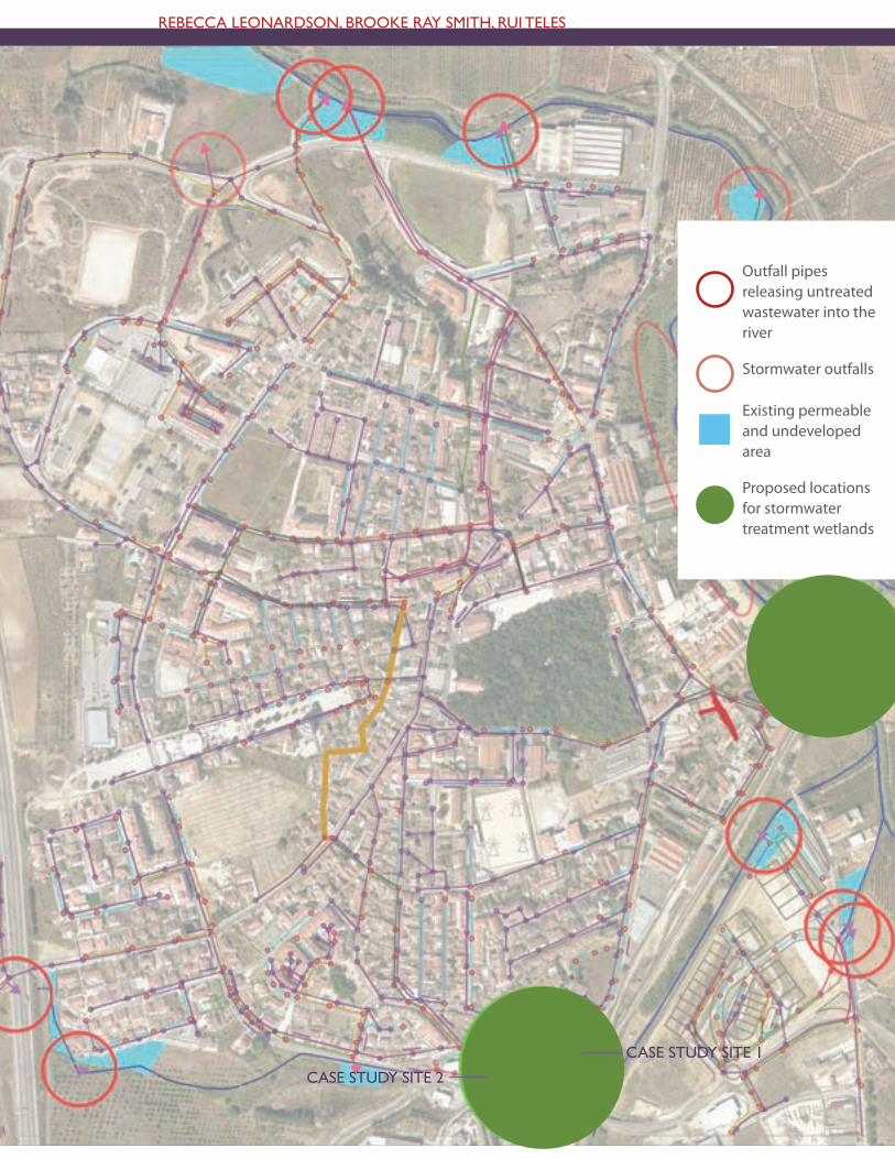
Outfall pipes releasing untreated wastewater into the river
Stormwater outfalls
Existing permeable and undeveloped area
Proposed locations for stormwater treatment wetlands
case study site 1
case study site 2
33
dePa
RtM
ent
of la
nd
sca
Pe aR
ch
itec
tu
Re a
nd
env
iRon
Men
tal Pla
nn
ing
cliMate aPPRoPRiate uRban WateR ManageMent
flooding, Water quality, and Water scarcity present challenges to urban Water resource management. using bombarral and vilar as case studies, We present a frameWork for decision-makers interested in developing urban stormWater and WasteWater management strategies in portugual.
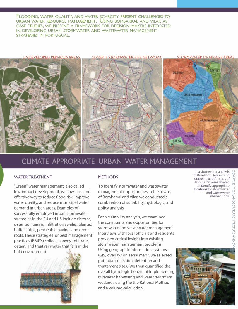
undeveloPed PeRvious aReas seWeR + stoRMWateR PiPe netWoRK stoRMWateR dRainage aReas
In a stormwater analysis of Bombarral (above and opposite page), maps of Bombarral were layered
to identify appropriate locations for stormwater
and wastewater interventions.
Methods
to identify stormwater and wastewater management opportunities in the towns of Bombarral and Vilar, we conducted a combination of suitability, hydrologic, and policy analysis.
For a suitability analysis, we examined the constraints and opportunities for stormwater and wastewater management. Interviews with local officials and residents provided critical insight into existing stormwater management problems. Using geographic information systems (GIS) overlays on aerial maps, we selected potential collection, detention and treatement sites. We then quantified the overall hydrologic benefit of implementing rainwater harvesting and water treatment wetlands using the the Rational Method and a volume calculation.
WateR tReatMent
"Green" water management, also called low-impact development, is a low-cost and effective way to reduce flood risk, improve water quality, and reduce municipal water demand in urban areas. Examples of successfully employed urban stormwater strategies in the EU and US include cisterns, detention basins, infiltration swales, planted buffer strips, permeable paving, and green roofs. These strategies or best management practices (BMP's) collect, convey, infiltrate, detain, and treat rainwater that falls in the built environment.
34
a l
ivin
g M
edit
eRR
an
ean
Riv
eR
Site 1 includes an existing concrete basin between two
industrial buildings which could be used to detain
water as drawn in the section illustration (right).
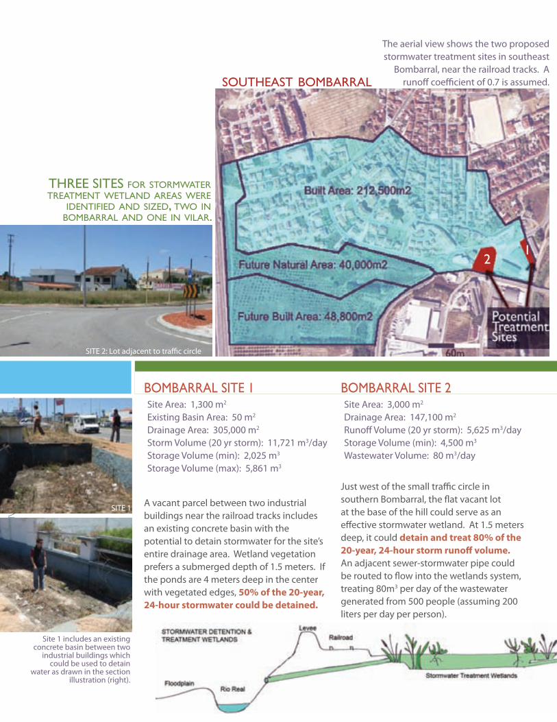
Site Area: 1,300 m2
Existing Basin Area: 50 m2
Drainage Area: 305,000 m2
Storm Volume (20 yr storm): 11,721 m3/dayStorage Volume (min): 2,025 m3
Storage Volume (max): 5,861 m3
boMbaRRal site 1Site Area: 3,000 m2
Drainage Area: 147,100 m2
Runoff Volume (20 yr storm): 5,625 m3/dayStorage Volume (min): 4,500 m3
Wastewater Volume: 80 m3/day
boMbaRRal site 2
The aerial view shows the two proposed stormwater treatment sites in southeast
Bombarral, near the railroad tracks. A runoff coefficient of 0.7 is assumed.
A vacant parcel between two industrial buildings near the railroad tracks includes an existing concrete basin with the potential to detain stormwater for the site’s entire drainage area. Wetland vegetation prefers a submerged depth of 1.5 meters. If the ponds are 4 meters deep in the center with vegetated edges, 50% of the 20-year, 24-hour stormwater could be detained.
Just west of the small traffic circle in southern Bombarral, the flat vacant lot at the base of the hill could serve as an effective stormwater wetland. At 1.5 meters deep, it could detain and treat 80% of the 20-year, 24-hour storm runoff volume. An adjacent sewer-stormwater pipe could be routed to flow into the wetlands system, treating 80m3 per day of the wastewater generated from 500 people (assuming 200 liters per day per person).
southeast bombarral
21
three sites for stormWater treatment Wetland areas Were
identified and sized, tWo in bombarral and one in vilar.
SITE 2: Lot adjacent to traffic circle
SITE 1
35
dePa
RtM
ent
of la
nd
sca
Pe aR
ch
itec
tu
Re a
nd
env
iRon
Men
tal Pla
nn
ing
stoRMWateR Wetland sites
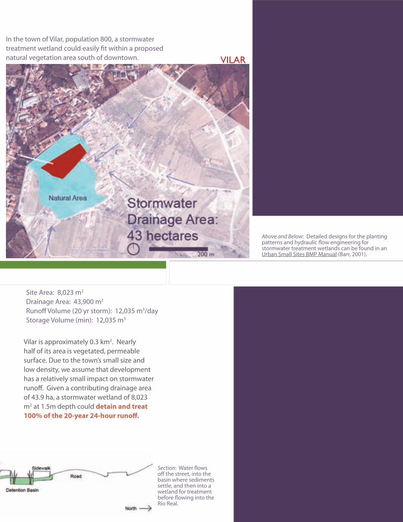
Above and Below: Detailed designs for the planting patterns and hydraulic flow engineering for stormwater treatment wetlands can be found in an Urban Small Sites BMP Manual (Barr, 2001).
Section: Water flows off the street, into the basin where sediments settle, and then into a wetland for treatment before flowing into the Rio Real.
Site Area: 8,023 m2
Drainage Area: 43,900 m2
Runoff Volume (20 yr storm): 12,035 m3/dayStorage Volume (min): 12,035 m3
vilaR site 1
In the town of Vilar, population 800, a stormwater treatment wetland could easily fit within a proposed natural vegetation area south of downtown. vilar
Vilar is approximately 0.3 km2. Nearly half of its area is vegetated, permeable surface. Due to the town’s small size and low density, we assume that development has a relatively small impact on stormwater runoff. Given a contributing drainage area of 43.9 ha, a stormwater wetland of 8,023 m2 at 1.5m depth could detain and treat 100% of the 20-year 24-hour runoff.
36
a l
ivin
g M
edit
eRR
an
ean
Riv
eR
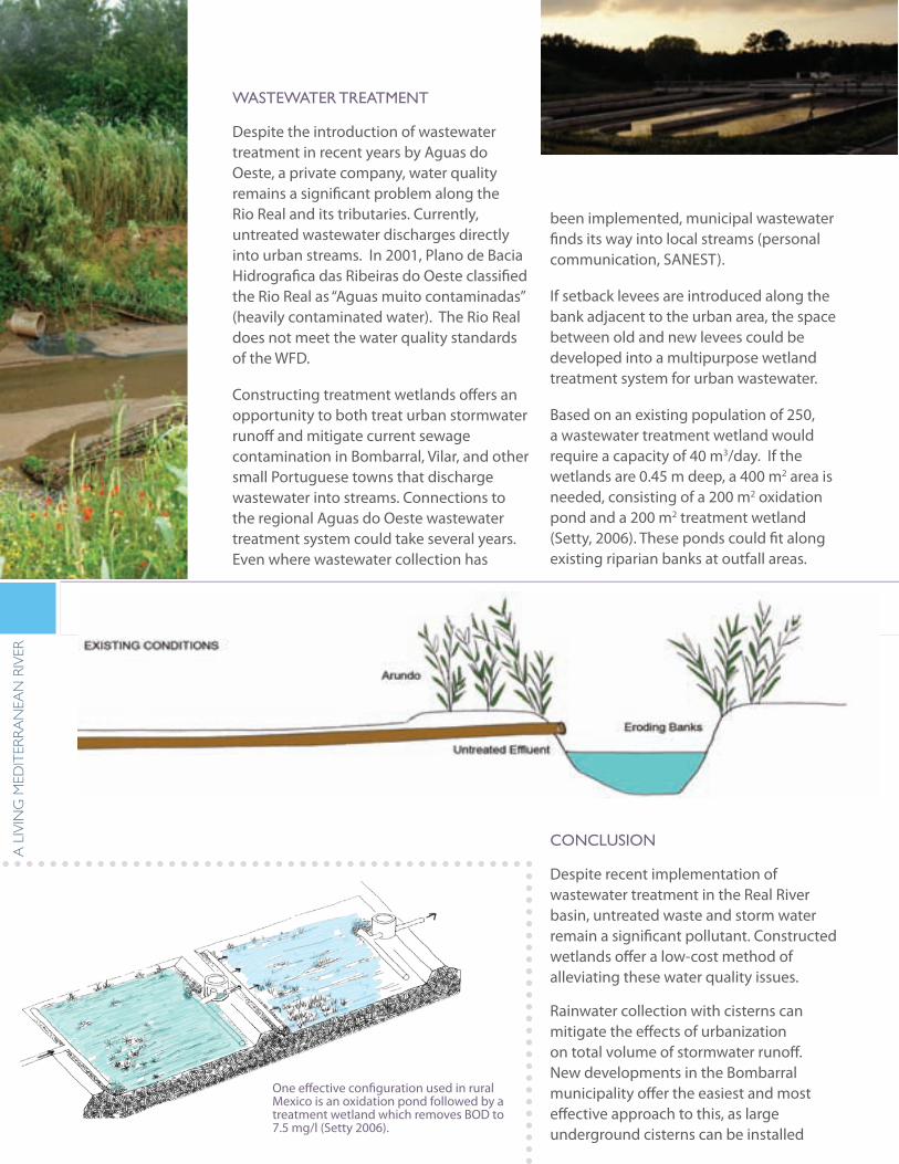
One effective configuration used in rural Mexico is an oxidation pond followed by a treatment wetland which removes BOD to 7.5 mg/l (Setty 2006).
WasteWateR tReatMent
Despite the introduction of wastewater treatment in recent years by Aguas do Oeste, a private company, water quality remains a significant problem along the Rio Real and its tributaries. Currently, untreated wastewater discharges directly into urban streams. In 2001, Plano de Bacia Hidrografica das Ribeiras do Oeste classified the Rio Real as “Aguas muito contaminadas” (heavily contaminated water). The Rio Real does not meet the water quality standards of the WFD.
Constructing treatment wetlands offers an opportunity to both treat urban stormwater runoff and mitigate current sewage contamination in Bombarral, Vilar, and other small Portuguese towns that discharge wastewater into streams. Connections to the regional Aguas do Oeste wastewater treatment system could take several years. Even where wastewater collection has
been implemented, municipal wastewater finds its way into local streams (personal communication, SANEST).
If setback levees are introduced along the bank adjacent to the urban area, the space between old and new levees could be developed into a multipurpose wetland treatment system for urban wastewater.
Based on an existing population of 250, a wastewater treatment wetland would require a capacity of 40 m3/day. If the wetlands are 0.45 m deep, a 400 m2 area is needed, consisting of a 200 m2 oxidation pond and a 200 m2 treatment wetland (Setty, 2006). These ponds could fit along existing riparian banks at outfall areas.
conclusion
Despite recent implementation of wastewater treatment in the Real River basin, untreated waste and storm water remain a significant pollutant. Constructed wetlands offer a low-cost method of alleviating these water quality issues.
Rainwater collection with cisterns can mitigate the effects of urbanization on total volume of stormwater runoff. New developments in the Bombarral municipality offer the easiest and most effective approach to this, as large underground cisterns can be installed
37
dePa
RtM
ent
of la
nd
sca
Pe aR
ch
itec
tu
Re a
nd
env
iRon
Men
tal Pla
nn
ing
Sections: In a riparian typology, a schematic section design for treatment wetlands includes: setting back existing steep banks, shortening pipe length to facilitate unchannelized flow through the wetland system, raising levees on the urban side, and implementing a site-specific design including vegetated submerged beds, oxidation and settling ponds and treatment wetlands.
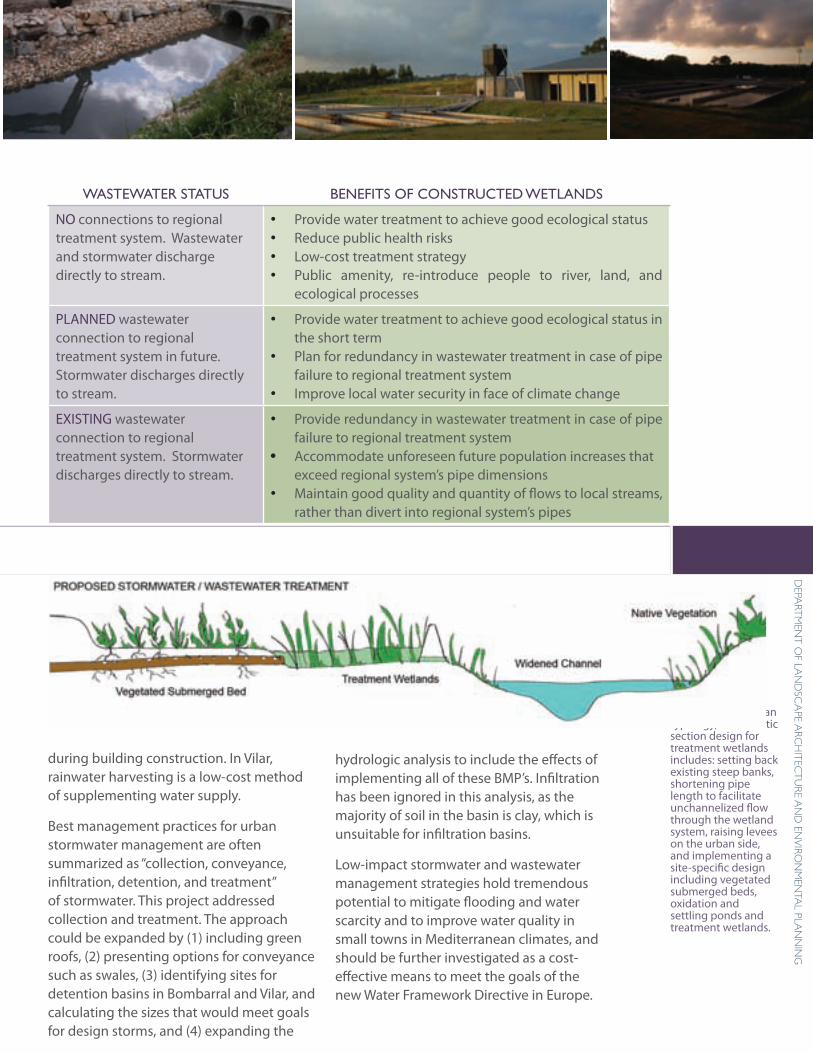
WasteWateR status benefits of constRucted Wetlands
NO connections to regional treatment system. Wastewater and stormwater discharge directly to stream.
Provide water treatment to achieve good ecological status •Reduce public health risks•Low-cost treatment strategy•Public amenity, re-introduce people to river, land, and •ecological processes
PLANNED wastewater connection to regional treatment system in future. Stormwater discharges directly to stream.
Provide water treatment to achieve good ecological status in •the short termPlan for redundancy in wastewater treatment in case of pipe •failure to regional treatment systemImprove local water security in face of climate change•
EXISTING wastewater connection to regional treatment system. Stormwater discharges directly to stream.
Provide redundancy in wastewater treatment in case of pipe •failure to regional treatment systemAccommodate unforeseen future population increases that •exceed regional system’s pipe dimensionsMaintain good quality and quantity of flows to local streams, •rather than divert into regional system’s pipes
during building construction. In Vilar, rainwater harvesting is a low-cost method of supplementing water supply.
Best management practices for urban stormwater management are often summarized as “collection, conveyance, infiltration, detention, and treatment” of stormwater. This project addressed collection and treatment. The approach could be expanded by (1) including green roofs, (2) presenting options for conveyance such as swales, (3) identifying sites for detention basins in Bombarral and Vilar, and calculating the sizes that would meet goals for design storms, and (4) expanding the
WasteWateR tReatMent
hydrologic analysis to include the effects of implementing all of these BMP’s. Infiltration has been ignored in this analysis, as the majority of soil in the basin is clay, which is unsuitable for infiltration basins.
Low-impact stormwater and wastewater management strategies hold tremendous potential to mitigate flooding and water scarcity and to improve water quality in small towns in Mediterranean climates, and should be further investigated as a cost-effective means to meet the goals of the new Water Framework Directive in Europe.
38
a l
ivin
g M
edit
eRR
an
ean
Riv
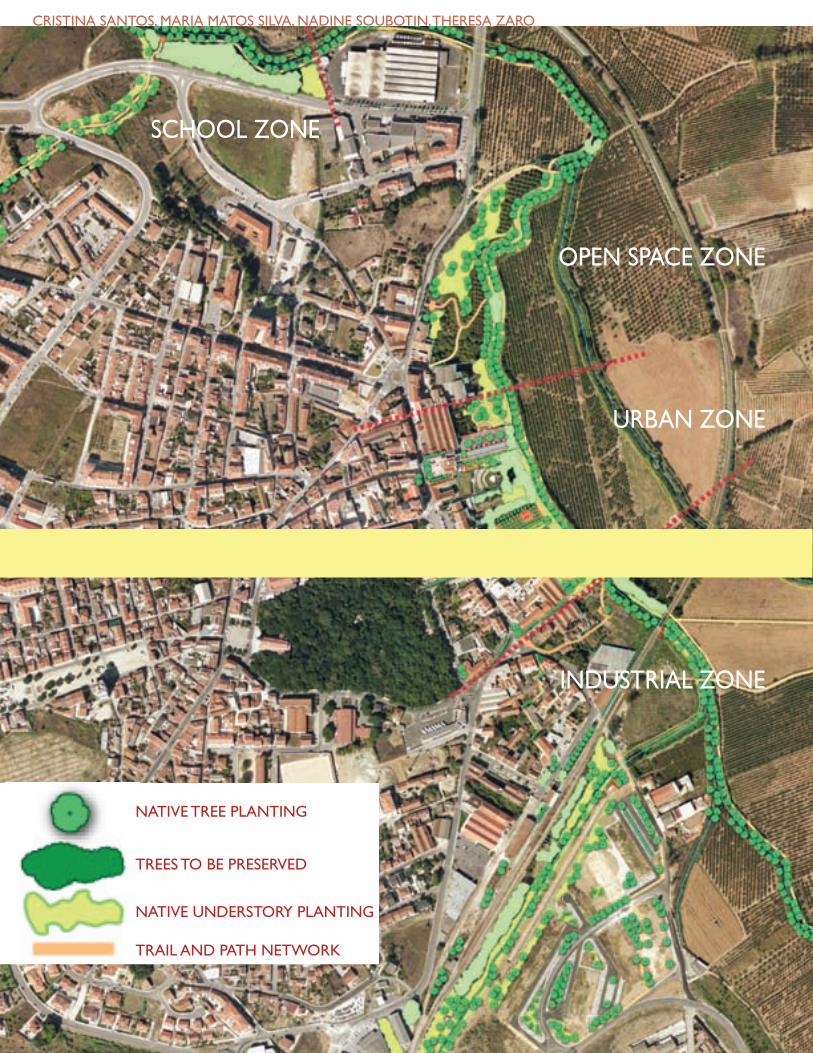
eRcRistina santos, MaRia Matos silva, nadine soubotin, theResa zaRo
uRban WateRfRont RegeneRation
school zone
uRban zone
industRial zone
oPen sPace zone
NATIVE TREE PLANTING
TREES TO BE PRESERVED
NATIVE UNDERSTORY PLANTING
TRAIL AND PATH NETWORK
39
dePa
RtM
ent
of la
nd
sca
Pe aR
ch
itec
tu
Re a
nd
env
iRon
Men
tal Pla
nn
ing
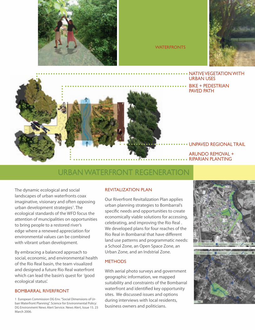
The dynamic ecological and social landscapes of urban waterfronts coax imaginative, visionary and often opposing urban development strategies1. The ecological standards of the WFD focus the attention of muncipalities on opportunities to bring people to a restored river’s edge where a renewed appreciation for environmental values can be combined with vibrant urban development.
By embracing a balanced approach to social, economic, and environmental health of the Rio Real basin, the team visualized and designed a future Rio Real waterfront which can lead the basin’s quest for ‘good ecological status’.
boMbaRRal RiveRfRont
1 European Commission DG Env. “Social Dimensions of Ur-ban Waterfront Planning”. Science for Environmental Policy: DG Environment News Alert Service. News Alert, Issue 15. 23 March 2006.
A metropolitAn crossroAd of industriAl, residentiAl,
recreAtionAl, And environmentAl interests, wAterfronts Are the
ideAl lAndscApes for exploring the boundAries of innovAtive And
comprehensive lAndscApe design.
Revitalization Plan
Our Riverfront Revitalization Plan applies urban planning strategies to Bombarral’s specific needs and opportunities to create economically viable solutions for accessing, celebrating, and improving the Rio Real . We developed plans for four reaches of the Rio Real in Bombarral that have different land use patterns and programmatic needs: a School Zone, an Open Space Zone, an Urban Zone, and an Indstrial Zone.
Methods
With aerial photo surveys and government geographic information, we mapped suitability and constraints of the Bombarral waterfront and identified key opportunity sites. We discussed issues and options during interviews with local residents, business owners and politicians.
native vegetation With uRban usesbiKe + PedestRian Paved Path
aRundo ReMoval + RiPaRian Planting
unPaved Regional tRail
uRban WateRfRont RegeneRation
40
a l
ivin
g M
edit
eRR
an
ean
Riv
eR
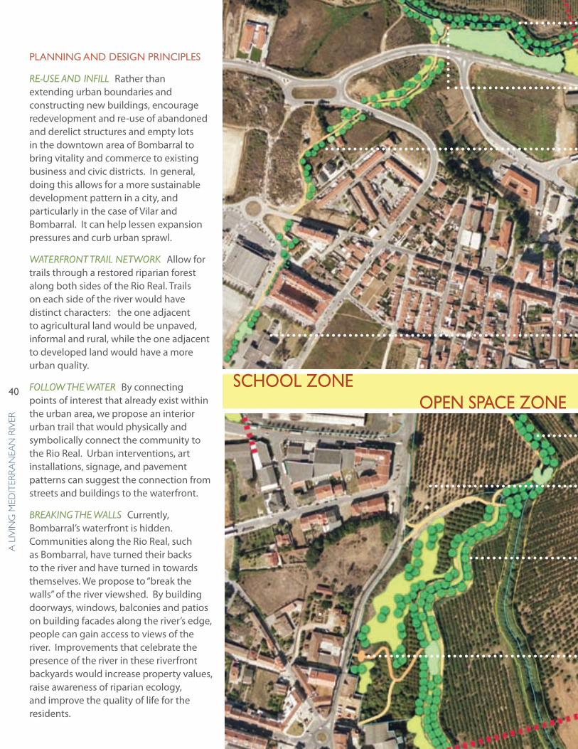
Planning and design PRinciPles
RE-USE and InfIll Rather than extending urban boundaries and constructing new buildings, encourage redevelopment and re-use of abandoned and derelict structures and empty lots in the downtown area of Bombarral to bring vitality and commerce to existing business and civic districts. In general, doing this allows for a more sustainable development pattern in a city, and particularly in the case of Vilar and Bombarral. It can help lessen expansion pressures and curb urban sprawl.
WatERfRont tRaIl nEtWoRk Allow for trails through a restored riparian forest along both sides of the Rio Real. Trails on each side of the river would have distinct characters: the one adjacent to agricultural land would be unpaved, informal and rural, while the one adjacent to developed land would have a more urban quality.
folloW thE WatER By connecting points of interest that already exist within the urban area, we propose an interior urban trail that would physically and symbolically connect the community to the Rio Real. Urban interventions, art installations, signage, and pavement patterns can suggest the connection from streets and buildings to the waterfront.
BREakIng thE WallS Currently, Bombarral’s waterfront is hidden. Communities along the Rio Real, such as Bombarral, have turned their backs to the river and have turned in towards themselves. We propose to “break the walls” of the river viewshed. By building doorways, windows, balconies and patios on building facades along the river’s edge, people can gain access to views of the river. Improvements that celebrate the presence of the river in these riverfront backyards would increase property values, raise awareness of riparian ecology, and improve the quality of life for the residents.
school zoneoPen sPace zone
41
dePa
RtM
ent
of la
nd
sca
Pe aR
ch
itec
tu
Re a
nd
env
iRon
Men
tal Pla
nn
ing
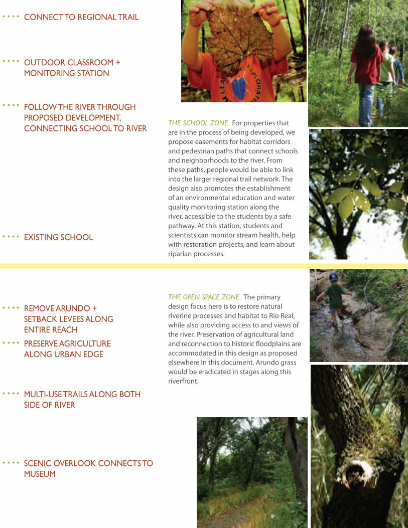
thE School ZonE For properties that are in the process of being developed, we propose easements for habitat corridors and pedestrian paths that connect schools and neighborhoods to the river. From these paths, people would be able to link into the larger regional trail network. The design also promotes the establishment of an environmental education and water quality monitoring station along the river, accessible to the students by a safe pathway. At this station, students and scientists can monitor stream health, help with restoration projects, and learn about riparian processes.
connect to Regional tRail
outdooR classRooM +MonitoRing station
folloW the RiveR thRough PRoPosed develoPMent, connecting school to RiveR
existing school
thE opEn SpacE ZonE The primary design focus here is to restore natural riverine processes and habitat to Rio Real, while also providing access to and views of the river. Preservation of agricultural land and reconnection to historic floodplains are accommodated in this design as proposed elsewhere in this document. Arundo grass would be eradicated in stages along this riverfront.
ReMove aRundo +setbacK levees alongentiRe Reach
PReseRve agRicultuRealong uRban edge
Multi-use tRails along both side of RiveR
scenic oveRlooK connects to MuseuM
42
a l
ivin
g M
edit
eRR
an
ean
Riv
eR
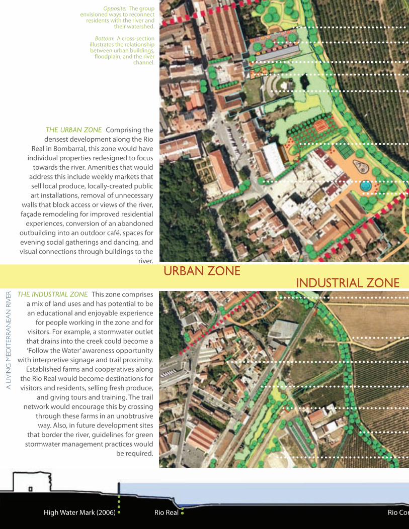
thE URBan ZonE Comprising the densest development along the Rio
Real in Bombarral, this zone would have individual properties redesigned to focus
towards the river. Amenities that would address this include weekly markets that sell local produce, locally-created public art installations, removal of unnecessary
walls that block access or views of the river, façade remodeling for improved residential
experiences, conversion of an abandoned outbuilding into an outdoor café, spaces for evening social gatherings and dancing, and visual connections through buildings to the
river.
thE IndUStRIal ZonE This zone comprises a mix of land uses and has potential to be an educational and enjoyable experience
for people working in the zone and for visitors. For example, a stormwater outlet that drains into the creek could become a ‘Follow the Water’ awareness opportunity
with interpretive signage and trail proximity. Established farms and cooperatives along
the Rio Real would become destinations for visitors and residents, selling fresh produce,
and giving tours and training. The trail network would encourage this by crossing
through these farms in an unobtrusive way. Also, in future development sites
that border the river, guidelines for green stormwater management practices would
be required.
uRban zone
Opposite: The group envisioned ways to reconnect
residents with the river and their watershed.
Bottom: A cross-section illustrates the relationship between urban buildings,
floodplain, and the river channel.
High Water Mark (2006) Rio Real Rio Corga
industRial zone
43
dePa
RtM
ent
of la
nd
sca
Pe aR
ch
itec
tu
Re a
nd
env
iRon
Men
tal Pla
nn
ing
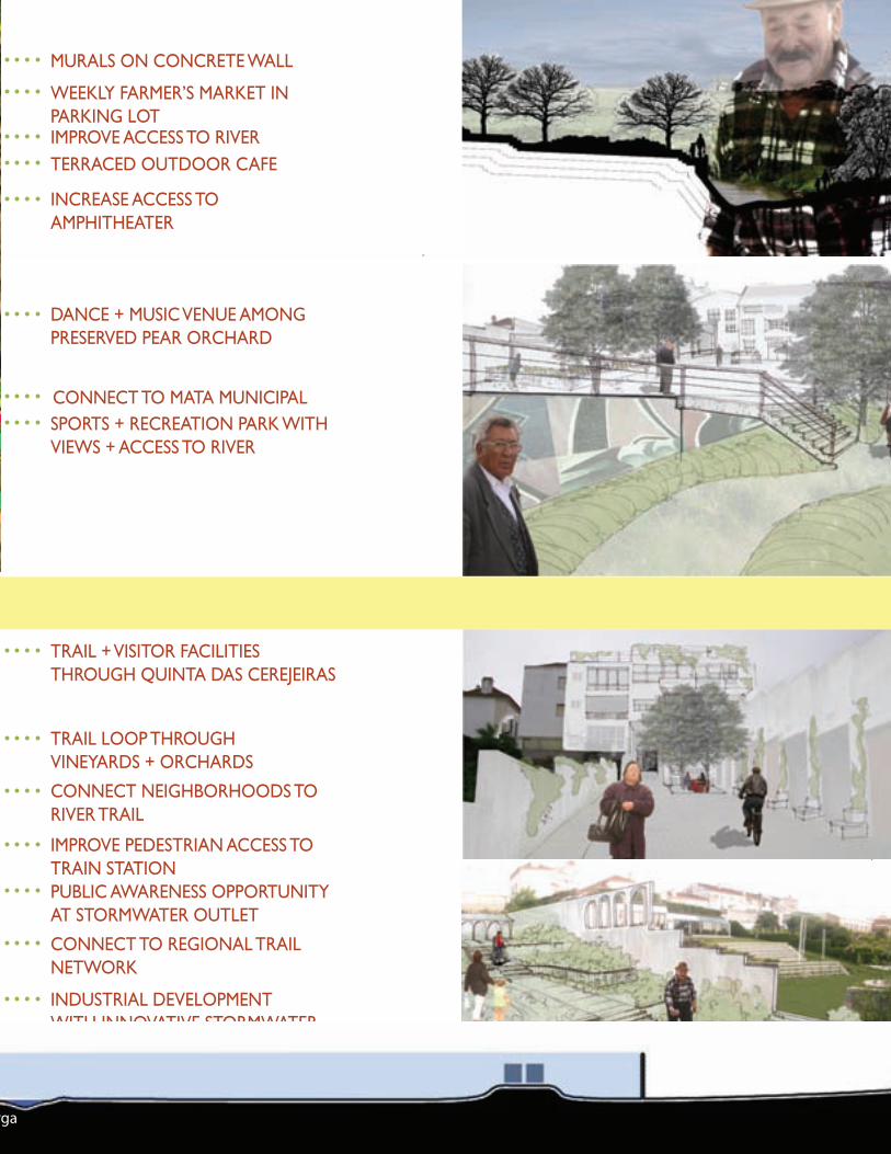
MuRals on concRete Wall
WeeKly faRMeR’s MaRKet in PaRKing lotiMPRove access to RiveRteRRaced outdooR cafe
incRease access to aMPhitheateR
dance + Music venue aMong PReseRved PeaR oRchaRd
connect to Mata MuniciPalsPoRts + RecReation PaRK With vieWs + access to RiveR
tRail + visitoR facilities thRough Quinta das ceReJeiRas
tRail looP thRoughvineyaRds + oRchaRds
connect neighboRhoods to RiveR tRail
iMPRove PedestRian access to tRain stationPublic aWaReness oPPoRtunity at stoRMWateR outlet
connect to Regional tRail netWoRK
industRial develoPMent With innovative stoRMWateR ManageMent stRategies
Train High Water Mark (2006)Rio Corga
44
a l
ivin
g M
edit
eRR
an
ean
Riv
eR
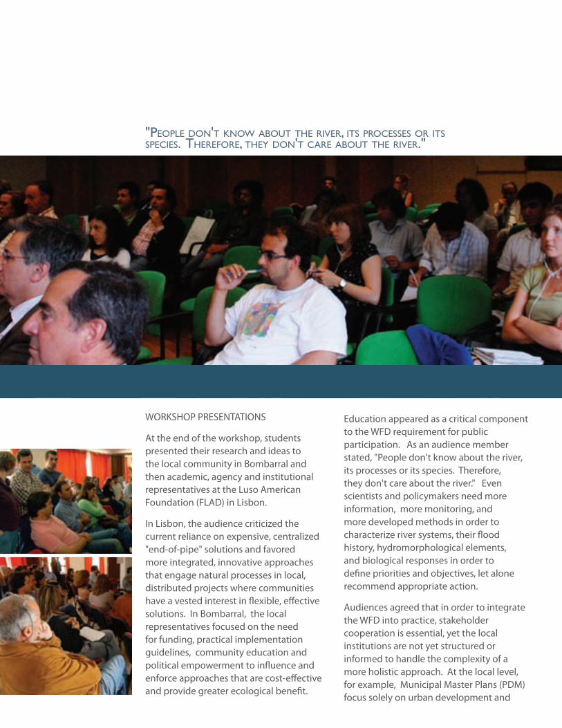
WORKSHOP PRESENTATIONS
At the end of the workshop, students presented their research and ideas to the local community in Bombarral and then academic, agency and institutional representatives at the Luso American Foundation (FLAD) in Lisbon.
In Lisbon, the audience criticized the current reliance on expensive, centralized "end-of-pipe" solutions and favored more integrated, innovative approaches that engage natural processes in local, distributed projects where communities have a vested interest in flexible, effective solutions. In Bombarral, the local representatives focused on the need for funding, practical implementation guidelines, community education and political empowerment to influence and enforce approaches that are cost-effective and provide greater ecological benefit.
Education appeared as a critical component to the WFD requirement for public participation. As an audience member stated, "People don't know about the river, its processes or its species. Therefore, they don't care about the river." Even scientists and policymakers need more information, more monitoring, and more developed methods in order to characterize river systems, their flood history, hydromorphological elements, and biological responses in order to define priorities and objectives, let alone recommend appropriate action.
Audiences agreed that in order to integrate the WFD into practice, stakeholder cooperation is essential, yet the local institutions are not yet structured or informed to handle the complexity of a more holistic approach. At the local level, for example, Municipal Master Plans (PDM) focus solely on urban development and
"people don't knoW about the river, its processes or its species. therefore, they don't care about the river."
45
dePa
RtM
ent
of la
nd
sca
Pe aR
ch
itec
tu
Re a
nd
env
iRon
Men
tal Pla
nn
ing
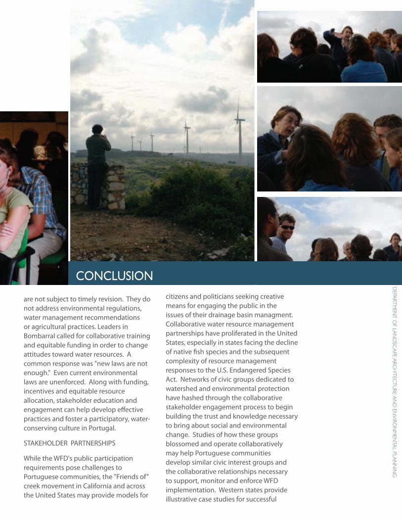
are not subject to timely revision. They do not address environmental regulations, water management recommendations or agricultural practices. Leaders in Bombarral called for collaborative training and equitable funding in order to change attitudes toward water resources. A common response was "new laws are not enough." Even current environmental laws are unenforced. Along with funding, incentives and equitable resource allocation, stakeholder education and engagement can help develop effective practices and foster a participatory, water-conserving culture in Portugal.
STAKEHOLDER PARTNERSHIPS
While the WFD's public participation requirements pose challenges to Portuguese communities, the "Friends of" creek movement in California and across the United States may provide models for
citizens and politicians seeking creative means for engaging the public in the issues of their drainage basin managment. Collaborative water resource management partnerships have proliferated in the United States, especially in states facing the decline of native fish species and the subsequent complexity of resource management responses to the U.S. Endangered Species Act. Networks of civic groups dedicated to watershed and environmental protection have hashed through the collaborative stakeholder engagement process to begin building the trust and knowledge necessary to bring about social and environmental change. Studies of how these groups blossomed and operate collaboratively may help Portuguese communities develop similar civic interest groups and the collaborative relationships necessary to support, monitor and enforce WFD implementation. Western states provide illustrative case studies for successful
conclusion
46
a l
ivin
g M
edit
eRR
an
ean
Riv
eR stakeholder collaboration in addressing critical watershed management issues through research, education, public outreach, trust-building and grant seeking. Funding, through grants and fellowships, should support the growth of civic groups dedicated to catchment-scale issues.
Cities with Mediterranean climate water challenges, such as Los Angeles, San Francisco and Portland, have drafted water managment plans as they face limited supplies, complexity, and reliabiltiy issues caused by global warming. These plans may provide ideas and resources for municipalities in Portugal striving to meet implementation requirements, but lacking precedents for including water management issues in planning documents.
Social capital, as embodied in horizontal networks of civic engagement, can help national and local stakeholders face uncertainty and complexity of new resource management regimes under the WFD. Education should not just focus on collecting scientific data, but also on how to
engage collaboratively in order to foster the social change required to sustain ecological change.
BEST MANAGEMENT PRACTICES
In order to cultivate effective approaches to water management, communities can collaborate to develop a knowledge-base of best management practices. Practical guidelines should discuss applicability, include case studies, design specifications, recommend maintenance and monitoring techniques and suggest reporting requirements. Once applied, projects should be evaluated for effectiveness in terms of stated goals which should include ecological, economic and social elements.
In order to begin, pilot projects, such as Arundo removal, levee setbacks, urban waterfront regeneration and wastewater treatment wetlands, should be funded and studied. Each project can inform the next generation of best management practices that promote efficiency, reuse and the emergence of a water-saving culture.
47
dePa
RtM
ent
of la
nd
sca
Pe aR
ch
itec
tu
Re a
nd
env
iRon
Men
tal Pla
nn
ing
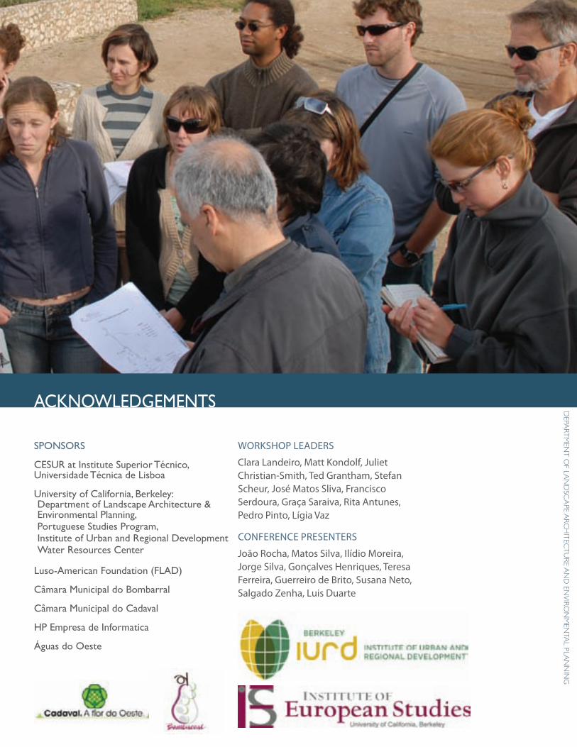
sPonsoRs
cesuR at institute superior técnico, universidade técnica de lisboa
university of california, berkeley:department of landscape architecture & environmental Planning, Portuguese studies Program,institute of urban and Regional developmentWater Resources center
luso-american foundation (flad)
câmara Municipal do bombarral
câmara Municipal do cadaval
hP empresa de informatica
Águas do oeste
WORKSHOP LEADERS
Clara Landeiro, Matt Kondolf, Juliet Christian-Smith, Ted Grantham, Stefan Scheur, José Matos Sliva, Francisco Serdoura, Graça Saraiva, Rita Antunes, Pedro Pinto, Lígia Vaz
CONFERENCE PRESENTERS
João Rocha, Matos Silva, Ilídio Moreira, Jorge Silva, Gonçalves Henriques, Teresa Ferreira, Guerreiro de Brito, Susana Neto, Salgado Zenha, Luis Duarte
acKnoWledgeMents
institute of urban and Regional development Working Paper WP-2009-01university of california Water Resources center contribution number 209institute of european studies Working Paper
isbn-13:978-0-9788896-3-0; isbn-10: 0-9788896-3-0