a level geography – physical geography - hazards · web view: systems in physical geography:...
TRANSCRIPT

A level Geography – Physical Geography - Hazards
The A level Geography course is divided into three components –
The King Alfred School Page 1
Coastal Systems & Landscapes
Name:

A level Geography – Physical Geography - Hazards
Component 1: Physical geography Component 2: Human geography Component 3: Geography fieldwork investigation
This booklet covers Section B: Coastal systems and landscapes. You must bring it to every lesson. If you miss a lesson you should catch up the work missed as soon as possible.
The King Alfred School Page 2

A level Geography – Physical Geography - Hazards
The King Alfred School Page 3

A level Geography – Physical Geography - Hazards
Learning objectives:
Understand the concept of systems in physical geography Apply this understanding to coastal landscapes
Specification content: Systems in physical geography: Systems concepts and their application to the development of coastal landscapes: inputs-outputs, energy, stores/components, flows/transfers, positive/negative feedback, dynamic equilibrium. The concepts of landform and landscape and how related landforms combine to form characteristic landscapes.
Key terms: Flow/transfer, input, store/component, system
Starter: You studied these terms at the start of the water and carbon cycles topic. Can you remember what they mean?
Stores/components –
Flows/connections –
Elements –
Attributes –
Relationships –
Boundaries –
The King Alfred School Page 4
Coasts as natural systems

A level Geography – Physical Geography - Hazards
Inputs –
Outputs –
Flows –
Isolated systems –
Closed systems –
Open systems –
Dynamic equilibrium –
Positive feedback –
Negative feedback –
Atmosphere –
Lithosphere –
Hydrosphere –
Biosphere –
The King Alfred School Page 5

A level Geography – Physical Geography - Hazards
Cascading system –
Coastal systems and landscapes
Coastal environments are open systems where inputs, components, flows and outputs combine to create a distinctive landscape. When there is balance between inputs and outputs a state of dynamic equilibrium is achieved, but if one of the elements changes there will be feedback and further change.
TASK: Look at page 89 in the textbook. Complete the coastal systems diagram below.
The King Alfred School Page 6
Inputs:
Components:
Components:
Outputs:

A level Geography – Physical Geography - Hazards
Reflection: Characteristic coastal landscapes are the combination of related landforms. You studied a coastal landscape for your summer work. How would you describe this coastal landscape?
Home learning: Find examples of a positive and a negative feedback mechanism in a coastal system. Produce an A4 sheet showing diagrams of these mechanisms to add to this pack. By ___________
Stretch and challenge (S&C): How is the coastal system linked to other natural systems?
The King Alfred School Page 7

A level Geography – Physical Geography - Hazards
Learning objectives:
Understand key terms and processes associated with sources of energy at the coast Know where sediment comes from and what sediment cells are
Specification content: Sources of energy in coastal environments: winds, waves (constructive and destructive), currents and tides. Low energy and high energy coasts. Sediment sources, cells and budgets.
Starter: What sources of energy are there at the coast?
Energy in coastal environments
Wind
Impact varies according to wind speed & prevailing wind direction Fetch – distance of open water over which wind blows without interruption Waves are created by the transfer of energy from the wind blowing over the sea Agent of erosion through abrasion
Waves
Created by the wind – primary agent shaping the coast
As waves come into shallow water the base of the wave is slowed down by friction with the sea bed, increasing the height and steepness of the wave. Eventually the upper part will plunge forward and the wave breaks.
The rush of water up the beach is the swash and the water running back down the beach is the backwash.
Waves may be constructive or destructive. Watch http://oceanexplorer.noaa.gov/edu/learning/player/lesson09.html and http://www.bbc.co.uk/education/guides/zct8bk7/video to find out more.
The King Alfred School Page 8
Coastal systems and processes 1
A level Geography – Physical Geography - Hazards
Most beaches have cycles of constructive and destructive waves. Constructive waves create a steeper beach profile, encouraging waves to become more destructive, then destructive waves reduce the beach angle, encouraging more constructive waves. This example of negative feedback works to maintain dynamic equilibrium, but this isn’t achieved as other factors, such as wind strength, vary.
The shape (topography) of the coastline affects wave action at the coast due to refraction.
The King Alfred School Page 9

A level Geography – Physical Geography - Hazards
Currents
Currents are permanent or seasonal movements of surface water. Longshore currents/littoral drift flow parallel to the shoreline Rip currents move away from the shoreline and are strong Upwelling is the movement of cold water from deep in the ocean towards the surface Watch http://oceanservice.noaa.gov/facts/current.html to find out more
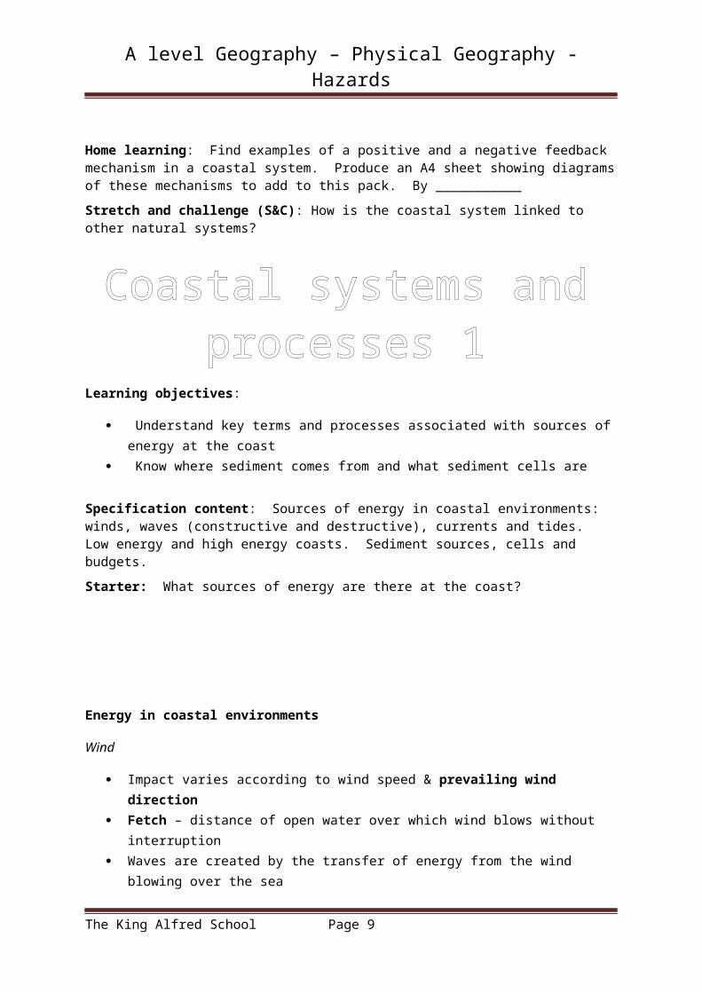
Tides
Rise and fall of the level of the sea caused by the pull of the sun and moon.
Tidal range is the difference between the height of the sea at high and low tide. Burnham on Sea has the second greatest tidal range in the world. This affects where weathering, erosion and deposition take place.
Tidal/storm surges occur when strong winds cause much higher water levels than usual.
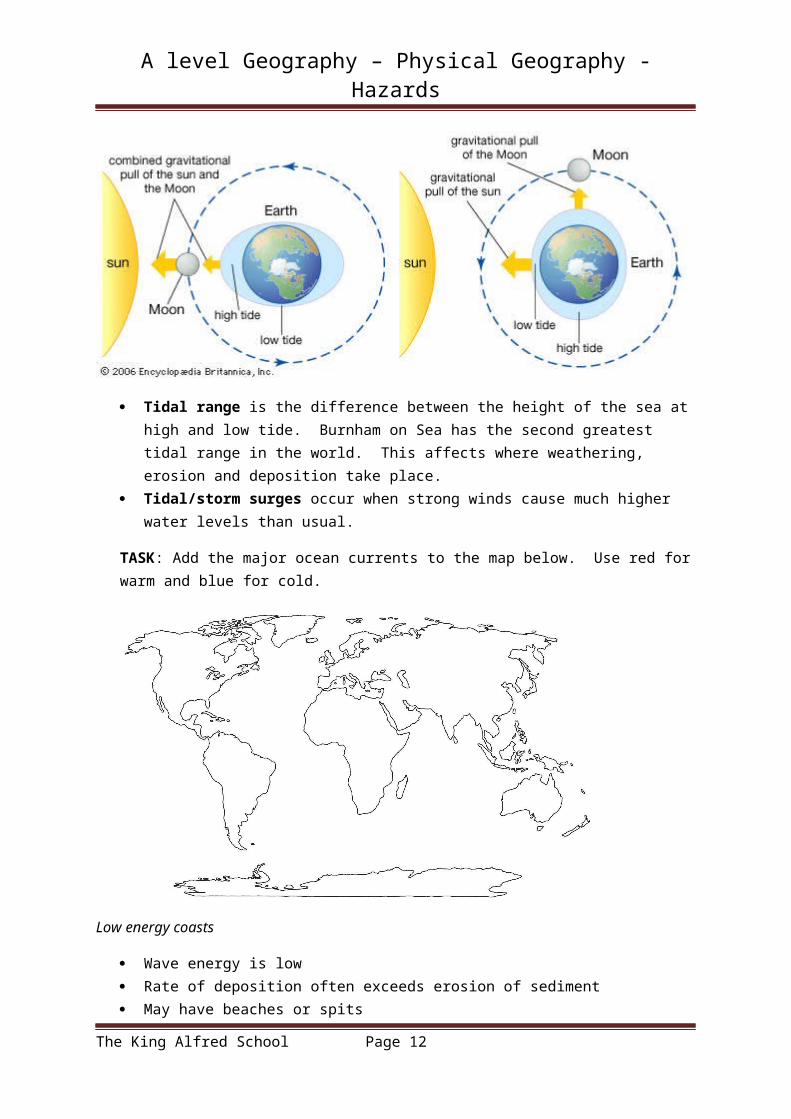
TASK: Add the major ocean currents to the map below. Use red for warm and blue for cold.
The King Alfred School Page 10

A level Geography – Physical Geography - Hazards
Low energy coasts
Wave energy is low Rate of deposition often exceeds erosion of sediment May have beaches or spits Include estuaries, inlets & sheltered bays i.e. Burnham-on-Sea
High energy coasts
Strong, steady prevailing winds create high energy waves Rate of erosion greater than rate of deposition May have headlands, cliffs and wave-cut platforms i.e. north Cornish coast
Sediment sources, cells and budgets
Coastal sediment comes from streams and rivers, estuaries, cliff erosion and offshore sand banks. It also includes fragments of biological material such as shells. To see an example watch https://www.youtube.com/watch?v=HHcFiI8rx_g
Sediment moves around the coastline in sediment cells, as shown in the diagram to the right. Within these cells, inputs and outputs are balanced.
The eleven large sediment cells are divided into sub cells to allow closer study.
The coastal sediment budget is the balance between sediment being added to and removed from the coastal system within each sediment cell. Calculating the sediment budget for a cell is complicated and relies on models and estimations. S&C – see https://pubs.usgs.gov/of/2008/1206/html/processes1.html
TASK: Using p. 97 in the text book, show a positive and negative coastal sediment budget below.
The King Alfred School Page 11
A level Geography – Physical Geography - Hazards
TASK: Answer the exam question below, then self-assess using the mark scheme your teacher will show you.
WWW:
EBI:
Reflection: Have a go at the test at http://www.bbc.co.uk/education/guides/zct8bk7/test - note any words you get wrong here so you can review them later.
Home learning: Produce revision notes/cards for the key words used so far in this topic. By _______
Useful links:
http://www.s-cool.co.uk/a-level/geography/coastal-processes/revise-it/beach-terminology
http://www.s-cool.co.uk/a-level/geography/coastal-processes/revise-it/wave-processes
The King Alfred School Page 12

A level Geography – Physical Geography - Hazards
Learning objectives:
Understand how weathering, mass movement, erosion, transportation and deposition shape landscapes
Apply this understanding to the coastline
Specification content: Geomorphological processes: weathering, mass movement, erosion, transportation and deposition. Distinctively coastal processes: marine: erosion – hydraulic action, wave quarrying, corrosion/abrasion, cavitation, solution, attrition; transportation: traction, suspension (longshore/littoral drift) and deposition; sub-aerial weathering, mass movement and run off.
Starter: Annotate the photograph of Durdle Door to show which processes you think may have played a role in its formation.
Coastlines are affected by:
The King Alfred School Page 13
Coastal systems and processes 2

A level Geography – Physical Geography - Hazards
Marine processes – connected with the sea i.e. waves, tides. Sub-aerial processes – operate on land i.e. weathering, mass movement, run off
The interaction of these processes creates a range of distinctive landscapes.
TASK: Define the following terms:
Term DefinitionWeathering
Mass movement
Erosion
Transportation
Deposition
Marine processes
Marine erosion
Coasts are eroded by:
Hydraulic action – force of water Wave quarrying – waves trap air in cracks Abrasion/corrosion – worn away by material sea has picked up Attrition – material carried by the sea is worn down Solution/corrosion – a form of weathering which contributes to coastal erosion
See https://www.youtube.com/watch?v=zUh3WeilFN4 to find out more. Recap using https://www.youtube.com/watch?v=SwrcVrJSdTk
The rate of coastal erosion is affected by:
Wave steepness & breaking point – steep waves are high energy waves Fetch – a longer fetch means more energy Sea depth – steep shelving seabed creates higher and steeper waves. Coastal configuration - refraction Beach presence – beaches absorb wave energy Human activity – i.e. sea defences
The geology of the coastline will affect erosion due to:
The King Alfred School Page 14

A level Geography – Physical Geography - Hazards
Lithology – characteristics of rocks, such as resistance to erosion and permeability – this leads to differential erosion
Structure – if rocks lie at parallel to the coast (concordant) they will erode differently to if they are at right angles (discordant)
Dip – if the layers of rock dip inland they will erode differently to if they dip towards the coast
TASK: Look at the map showing the geology of the Purbeck coast in Dorset. How has the geology of this area influenced erosion at the coast?
Marine transportation
The King Alfred School Page 15

A level Geography – Physical Geography - Hazards
Energy not used for erosion or dissipated through friction is used to transport material at the coast. This occurs through a combination of:
Traction – large stones roll along the seabed & beach in high energy environments Saltation – small stones bounce along the seabed and beach in high energy conditions Suspension – very small particles of sand and silt are carried along by moving water Solution – dissolved materials are transported within the water
See http://www.alevelgeography.com/marine-processes/ to watch these processes in action.
When waves approach the shore at an angle material is moved along the coastline through longshore drift. Watch https://www.youtube.com/watch?v=f-Z8FwDLQL8 to see how.
TASK: Draw a diagram below to show the process of longshore drift. Use p. 100 in the textbook.
Talking point: Is there any evidence of longshore drift along our local coastline?
Fieldwork link: To find out how you could investigate longshore drift in the field see https://www.rgs.org/OurWork/Schools/Fieldwork+and+local+learning/Planning+your+fieldtrip/Fieldwork+locations/Jurassic+Coast+of+Dorset+and+East+Devon/Longshore+drift+investigation.htm
Marine deposition
Where waves are low energy or there is a high supply of material, marine deposition may take place. Material is deposited when there is a reduction in energy, which could be due to a decrease in velocity or volume of water. This could occur when:
Sand and shingle accumulate more rapidly than they are removed Waves slow after they break Water pauses at the top of the swash Water percolates into beach material as the backwash takes it down the beach
Aeolian deposition
The King Alfred School Page 16

A level Geography – Physical Geography - Hazards
Wind transports and deposits sediments at the coast. During the day, the wind usually blows from the sea to the land, carrying sand-sized sediment close to the ground over short distances thorough:
Surface creep – similar to traction Saltation – wind temporarily lifts and to heights of up to one metre for up to 20-30 metres
Beaches and dunes are shaped by these processes.
Sub-aerial processes
Sub-aerial weathering
These processes break down the coastline, weaken rocks and allow erosion to happen more easily. Material is broken down in situ. They can be divided into:
Mechanical/physical weathering – i.e. freeze thaw Biological weathering Chemical weathering – i.e. solution
Mass movement
Mass movements include Landslides, Rock falls, Mudflows, Rotational slip/slumping & Soil creep.
These processes are affected by:
How the sediment sticks together (cohesion) & its grain size Slope height and angle Temperature and level of saturation
Run-off
This may take the form of a stream emerging in a bay or cascading over a cliff or water flowing over the surface.
TASK: Look at http://www.alevelgeography.com/sub-aerial-processes/ - produce a summary sheet (max 2 sides of A4) showing the sub-aerial processes operating at the coast and add it to this pack.
Reflection: You researched a stretch of coastline for your summer work. Which processes were dominant on this stretch of coastline? Why?
Home learning: Complete summary sheet showing sub-aerial processes. By ________________
Stretch and challenge: Visit a local beach and take photographs to show evidence of any of the processes studied during this lesson. Produce a photo collage of this evidence and put it in this pack – you could do this using https://pic-collage.com/
The King Alfred School Page 17

A level Geography – Physical Geography - Hazards
Learning objectives:
Understand the origin and development of a range of landforms of coastal erosion Apply this to a range of examples from the UK and beyond
Specification content: Origin and development of landforms and landscapes of coastal erosion: Cliffs and wave cut platforms, cliff profile features including caves, arches and stacks; factors and processes in their development.
Starter: Which factors influence the ways coastal erosion affects the coastline?
Watch https://www.youtube.com/watch?v=SoOb4fg7cqk to review this and start to explore the landforms that result.
Headlands and Bays
Cliffs and wave-cut platforms
The King Alfred School Page 18
Landforms of coastal erosion

A level Geography – Physical Geography - Hazards
Caves, arches & stacks
TASK: Carry out research into the following landforms.
Headlands and bays in the San Francisco Bay area of California Headlands and bays on the Purbeck Coast in Dorset Cliff retreat and wave cut platform at Flamborough Head in Yorkshire The Twelve Apostles in southern Australia Old Harry Rocks in Purbeck, Dorset
For each landform include a photograph and an explanation of how the landform developed due to marine processes. Add your work to this pack.
Reflection: Look at the image on the PowerPoint – what landforms can you identify? How did they form?
Home learning: Complete research task by __________________
The King Alfred School Page 19

A level Geography – Physical Geography - Hazards
Learning objectives:
Understand the origin and development of a range of landforms of coastal deposition Apply this to a range of examples from the UK and beyond
Specification content: Origin and development of landforms and landscapes of coastal deposition. Beaches, simple and compound spits, tombolos, offshore bars, barrier beaches and islands and sand dunes; factors and processes in their development.
Starter: You researched a stretch of coastline for your summer work. Which erosional landforms are there on this stretch of coastline? How did they form?
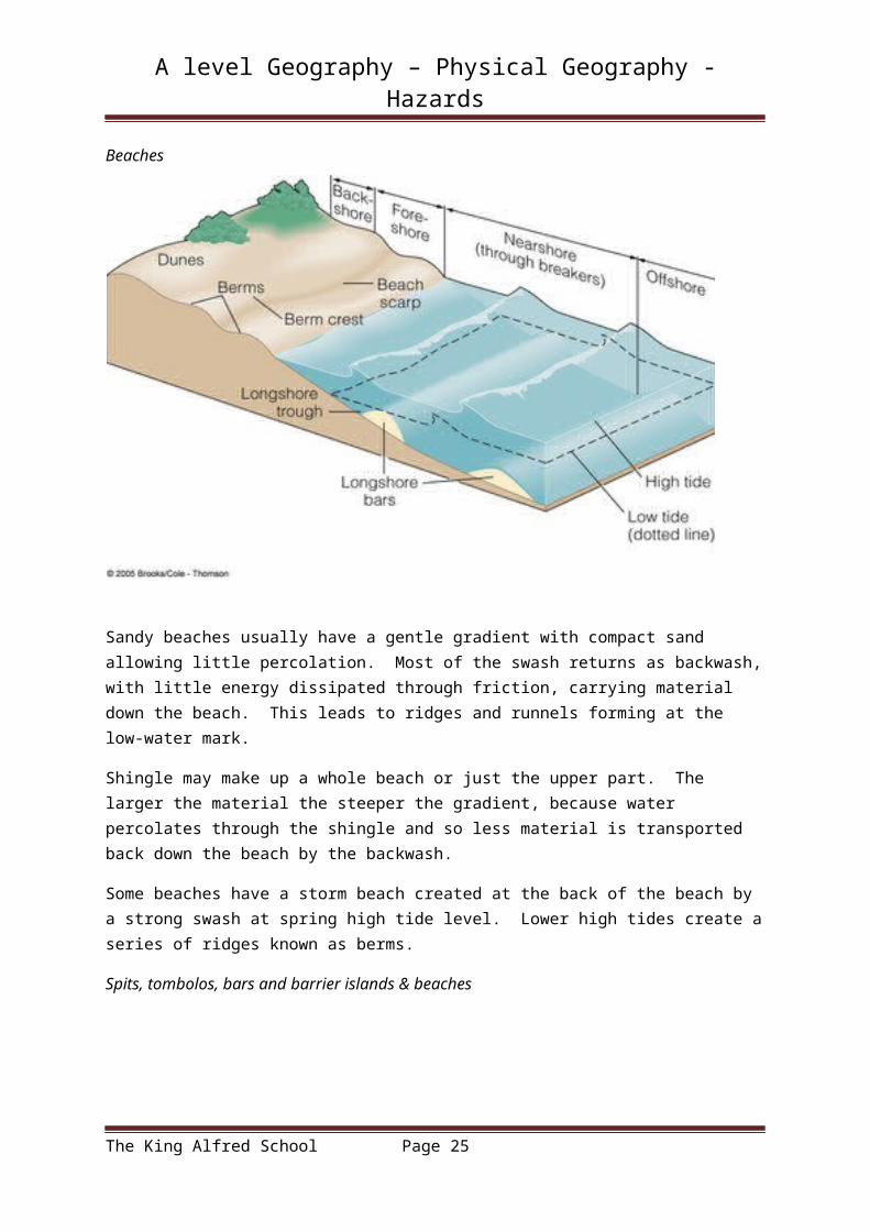
Beaches
The King Alfred School Page 20
Landforms of coastal deposition

A level Geography – Physical Geography - Hazards
Sandy beaches usually have a gentle gradient with compact sand allowing little percolation. Most of the swash returns as backwash, with little energy dissipated through friction, carrying material down the beach. This leads to ridges and runnels forming at the low-water mark.
Shingle may make up a whole beach or just the upper part. The larger the material the steeper the gradient, because water percolates through the shingle and so less material is transported back down the beach by the backwash.
Some beaches have a storm beach created at the back of the beach by a strong swash at spring high tide level. Lower high tides create a series of ridges known as berms.
Spits, tombolos, bars and barrier islands & beaches
A simple spit is either straight or recurved and doesn’t have minor spits along its landward edge. A compound spit is similar to a simple spit but has a number or minor spits along the landward side.
Sand dunes
The King Alfred School Page 21

A level Geography – Physical Geography - Hazards
Watch https://www.youtube.com/watch?v=gKU1K8n6jYM to find out more.
TASK: Carry out research into the following landforms.
Spurn Head Spit in East Yorkshire Sandy Hook Spit in New Jersey, USA Chesil beach, a tombolo in Dorset Arabat Spit, a bar in the Sea of Azov The Lido of Venice, a barrier beach Berrow Sand Dunes in Somerset, an example of a psammosere
For each landform include a photograph and an explanation of how the landform developed due to marine processes. Add your work to this pack.
Reflection: Play coasts Pictionary to review the coastal systems, processes and landforms studied so far. Note any terms you are unfamiliar with here so you can review them later.
Home learning: Complete the research task and answer the exam questions on the next page by ________________.
Stretch & challenge: Visit Berrow Sand Dunes and take photographs to show the different features of this psammosere. How did these form?
The King Alfred School Page 22

A level Geography – Physical Geography - Hazards
The King Alfred School Page 23

A level Geography – Physical Geography - Hazards
Learning objectives:
Understand the origin and development of estuarine mudflat/saltmarsh environments Apply this to a range of examples from the UK and beyond
Specification content: Estuarine mudflat/saltmarsh environments and associated landscapes; factors and processes in their development.
Starter: Which word in each row below is the odd one out? Why?
Tombolo Spit Wave cut platform BarNotch Berm Cusp Storm beachHydraulic action Traction Attrition AbrasionMud flow Soil creep Slumping Hydration
Mudflats
‘The mudflats are formed by the perfect balance of the rivers dropping their sediment and the erosion caused by gentle wave action from the rise and fall of the tide. They are constantly being washed with new salt water as the tide rises. The salt water is diluted by the constant flow of river water in the area. Plants and animals that live here must be able to cope with such dynamically changing conditions. These plants and animals are called Halophytes, which means they can live in a salty environment. The animals are adapted to hide when the tide goes out, either directly under rocks or by burrowing into the mud. For example, Sand Hoppers swim in the brackish (half salt, half fresh) water, and then hide under rocks at low tide. Worms such as Lugworm, and bivalves such as Cockles come to the surface only when the tide is in.
Plants are adapted in the same ways that desert plants are adapted to the dry environment. Sea Purslane has silver scaled, fleshy leaves. The fleshiness conserves water and the scales that protect the leaf make it appear silver. Glasswort is a succulent plant that was used to make the soda ash needed for glass making. These two species grow on the mud, making a salt marsh. They are the first or ‘pioneer’ species that allow the salt marsh to change gradually over time.
The plants play an important role in building up the sediment until the soil is deep enough to support trees. This process is called succession. The mud is gradually stabilised by the roots of the pioneer plants, sea purslane and glasswort, allowing cord grass or rice grass to grow. Next grow the rushes, such as hard rush and salt marsh rush, and sedges including brown sedge, followed by shrubs such as gorse and willow. As the vegetation changes, so too do the animals - they change from marine to land-living, such as otter to fox.’
From: http://www.pembrokeshirecoast.org.uk/?PID=149
Salt marshes
The King Alfred School Page 24
Estuarine mudflat/ saltmarsh environments
A level Geography – Physical Geography - Hazards
‘Salt marshes forms in coastal areas that already have mud flats. They usually form in areas that are well sheltered, such as creeks, inlets and estuaries where fine sediments can be deposited. They also form behind spits and artificial sea defences where tidal waters can flow gently and deposit fine sediments. Salt marshes are exposed at low tide and at least partially flooded at high tide, so only salt resistant forms of vegetation can grow there. They are typically very flat, with numerous muddy channels and creeks cutting through them, making them very dangerous places to be as the tide comes in.’
From: http://www.geography-site.co.uk/pages/physical/coastal/saltmarsh.html
To see an example of a saltmarsh watch https://www.youtube.com/watch?v=LGOECERzlws
TASK: Working individually or in a pair, research a named illustrative example (not developed case study) from a local UK area and one from beyond the UK - identify an area of mudflats and saltmarsh and identify the individual features that have combined to form the distinctive landscape they see.
Reflection: Look at the following exam question.
Describe the characteristics, and explain the formation, of two or more landforms resulting from coastal deposition (such as beaches, spits, bars, dunes and salt marshes). 20 marks
Produce a plan for this answer.
Home learning: Answer the exam question above by _____________
The King Alfred School Page 25

A level Geography – Physical Geography - Hazards
Learning objectives:
Understand eustatic, isostatic and tectonic sea level change Understand coastlines of emergence and submergence and associated landforms Apply this to a range of examples from the UK and beyond
Specification content: Eustatic, isostatic and tectonic sea level change: major changes in sea level in the last 10,000 years. Coastlines of emergence and submergence. Origin and development of associate landforms: raised beaches, marine platforms; rias, fjords, Dalmatian coasts.
Starter: What do you already know about sea level change? Why do sea levels rise and fall?
Sea level change
‘A eustatic sea level change occurs when there is a global change in the amount of water stored in the oceans, or a change in the geometry of the ocean basins which alters the volume of water they can hold. When the sea level changes in response to the amount of water stored in ice caps this is called glacial-eustasy. If the two main ice caps — Greenland and Antarctica — melted, then it is calculated that the oceans would rise by 66 metres.
During glacial periods areas of land are covered with thick layers of ice. The weight of the ice causes the surface of the Earth’s crust to deflect downwards. At the end of the glacial period the ice melts and the crust can rebound. This is known as an isostatic sea level change and it causes a relative sea level change as it is the land rising, not the amount of water increasing.’
From: http://www.bgs.ac.uk/discoveringGeology/climateChange/general/coastal.html?src=topNav
Sea levels may also change in a particular place due to tectonic activity, such as faults slipping.
Changes in sea level for these reasons have happened throughout history. The current sea level reflects changes since the last glacial maximum 18 000 years ago. Look at pages 112-113 in the textbook to find out more; also watch https://www.youtube.com/watch?v=ey3VcmhUbY8
The King Alfred School Page 26
Sea level change & landforms of emergence and submergence

A level Geography – Physical Geography - Hazards
TASK: Answer the exam questions below & peer assess using the mark scheme from your teacher
(4 marks)
(4 marks)
The King Alfred School Page 27

A level Geography – Physical Geography - Hazards
Coastlines of submergence & related features
When sea levels rise, some coastal areas are submerged. Rias are formed when rising sea levels drown a river valley. An example is the Fowey estuary in Cornwall.
Fjords are drowned glacial valleys. Examples are found in Norway, southwestern New Zealand, British Colombia in Canada, southern Chile and Greenland.
Watch https://www.youtube.com/watch?v=U_2DtNLnc0M to find out more about fjords.
The King Alfred School Page 28

A level Geography – Physical Geography - Hazards
A Dalmatian coast is formed when flooded valleys run parallel to the coast rather than at right angles to it. This creates islands and peninsulas lying parallel to the mainland.
Coastlines of emergence and related features
When land rises due to isostatic recovery, former wave cut platforms and beaches are raised above the present sea level.
There are many examples of raised beaches on the west coast of Scotland.
When a larger area of gently sloping land is exposed it may be referred to as a marine platform.
Watch https://www.youtube.com/watch?v=p_AUkB9EGBo to find out more about raised beaches.
TASK: Answer the exam questions on the next page & peer assess with the mark scheme from your teacher. This is from the old specification and so doesn’t quite fit the format of the new questions.
The King Alfred School Page 29

A level Geography – Physical Geography - Hazards
Reflection: Look back at your exam answers - what did you do well? What could you improve?
WWW:
EBI:
Home learning: Review this lesson using http://www.s-cool.co.uk/a-level/geography/deltas-and-estuaries-and-changes-to-coastal-areas/revise-it/sea-level-change
The King Alfred School Page 30

A level Geography – Physical Geography - Hazards
Learning objectives:
Know how climate has changed recently, how it is predicted to change and the potential impact on coasts.
Apply this to a range of examples from the UK and beyond
Specification content: Recent and predicted climatic change and potential impact on coasts. The relationship between process, time, landforms and landscapes in coastal settings.
Starter: Answer the following exam question.
Peer assess your answer using the mark scheme your teacher will share with you.
The King Alfred School Page 31
Sea level change & landforms of emergence and submergence

A level Geography – Physical Geography - Hazards
Sea level has risen over the last 10 000 years and the rate of increase has recently risen from 1-2mm/yr to 4-5mm/yr. Look at https://www.ipcc.ch/pdf/unfccc/cop19/3_gregory13sbsta.pdf to find out more about these changes and also predictions for the future.
TASK: Find out how sea level change may affect coastlines in the USA by looking at https://www.epa.gov/climate-impacts/climate-impacts-coastal-areas . Complete the table below.
Impact ExplanationSea level rise
Changing precipitation and storm surges
Coastal water temperature
Shellfish and coral reefs
TASK: Carry out your own research to find out how either the coastal landscape you studied for your summer work or the North Somerset coastal landscape is likely to be affected by sea level change in the future.
Reflection: Take part in a kahoot.it quiz to review your work on coasts so far.
Home learning: Complete the research task and answer the exam question below by ____________
Discuss the relative importance of two or more processes responsible for shaping the coast (such as marine erosion, transportation; deposition and land-based sub-aerial weathering, mass movement and runoff). 20 marks
Stretch and challenge: Review this topic using https://www.pmfias.com/marine-landforms-erosional-depositional-landforms-coastlines-coastline-emergence-submergence/
The King Alfred School Page 32

A level Geography – Physical Geography - Hazards
Learning objectives:
Know why people intervene in coastal landscapes Understand hard and soft engineering approaches to managing coastal flood and erosion
risk
Specification content: Human intervention in coastal landscapes. Traditional approaches to coastal flood and erosion risk: hard and soft engineering.
Starter: Why does Burnham on Sea need a sea wall? Watch https://www.youtube.com/watch?v=b6HeIXYxvuc What other reasons are there for people intervening in coastal areas?
‘The development of the seafront at Burnham-on-sea began in 1911 when the reinforced concrete widewalk pavement and wall were constructed.
The development of the South Esplanade, from the jetty to the mouth of the Brue, took place some 20 years later in 1931.
The current impressive sea wall was inaugurated on June 16, 1988 as a result of the damage done to during the huge storms of December 1981 when the town was inundated with seawater. The wall is just over one mile long and cost £7.5 million to build.’
From: http://www.burnham-on-sea.com/seafront-history.shtml
TASK: Define the key terms below using p.116 in the Hodder textbook.
Managed retreat –
Soft engineering –
Hard engineering –
The King Alfred School Page 33
Coastal management – hard and soft engineering

A level Geography – Physical Geography - Hazards
TASK: Complete the table below to show different types of coastal defences & how they are used in our local area. If they aren’t used in our area explain why you think this is.
HARD ENGINEERING
Approach Description Use in local area?Sea wall
Rock armour
Gabions
Revetments
Groynes
Cliff fixing
Offshore reefs
The King Alfred School Page 34

A level Geography – Physical Geography - Hazards
Barrages
SOFT ENGINEERING
Approach Description Use in local area?Beach nourishment
Dune regeneration
Managed retreat
Land-use management
Do nothing
Reflection: Why might Burnham on Sea need a new sea wall in the future?
The King Alfred School Page 35

A level Geography – Physical Geography - Hazards
Learning objectives:
Know what shoreline management plans and integrated coastal zone management are and why they are considered sustainable approaches
Investigate the impact of the N Devon/Somerset SMP on our local coastline
Specification content: Human intervention in coastal landscapes. Sustainable approaches to coastal flood risk and coastal erosion management: shoreline management/integrated coastal zone management.
Starter: What are shoreline management plans (SMPs)? Look at p. 122 in the Hodder text book to find out.
Why are shoreline management plans important for people who live in coastal areas? Watch https://www.youtube.com/watch?v=kVpu3MNoilA to find out more.
What does the SMP for our local coastline say? Look at http://www.ndascag.org/NDAS_SMP2_Summary_EMF_July2010_12082010.pdf - how is the area between Burnham and Brean Down managed?
The King Alfred School Page 36
Coastal management – sustainable approaches

A level Geography – Physical Geography - Hazards
TASK 1: Produce an A4 summary sheet including:
- the background to SMPs- how the British coastline is separated into SMPs- the key aims and features of SMPs- a mini-illustrative example of the features of the section of our local SMP related to Burnham to
Brean Down
TASK 2: What is integrated coastal zone management? Read pages 123-124 in the Hodder text book and watch the 20 minute talk at https://www.youtube.com/watch?v=g3uD-m6DPcc to find out:
- What are the origins of ICZM?- What is the background to why an integrated coastal management is needed?- Why is concentrating on people and economic activity putting pressure on coastal environments?- What are the specific issues facing coastal environments in the future?- Who are the stakeholders, who should be considered when thinking about coastal management?- How can ICZM be viewed as a cyclical process?
Reflection: What are the limitations of managing our coastlines using SMPS and ICZMs?
Home learning: Complete both tasks by _______________________
The King Alfred School Page 37

A level Geography – Physical Geography - Hazards
Learning objectives:
Illustrate and analyse how the Sundarbans present risks and opportunities for human occupation and development
Evaluate human responses of resilience, mitigation and adaptation
Specification content: Case study of a contrasting coastal landscape beyond the UK to illustrate and analyse how it presents risks and opportunities for human occupation and development and evaluate human responses of resilience, mitigation and adaptation.
Starter: Watch the video clip at https://www.usaid.gov/bangladesh/environment-and-global-climate-change - what are the Sunderbans like? Why do they need protection?
TASK: Working in small groups, produce a report/presentation/poster describing, analysing and evaluating a range of themes relating to how the human population of the Sundarbans interacts with their coastal landscape, including:
- an understanding of the coastal processes that combined to create this unique coastal landscape
- the challenges and risks of living in the Sundarbans- the opportunities offered by living in the Sundarbans- the human response to the challenges of the Sundarbans, including strategies aimed at
resilience, mitigation and adaptation- the potential for possible sustainable development in the future for the people of the
Sundarbans.
Deadline: _____________________
Reflection: What implications could climate change have for people and development in the Sundarbans in the future?
The King Alfred School Page 38
Case study: The Sundarbans, Bangladesh

A level Geography – Physical Geography - Hazards
Learning objectives:
Use quantitative and qualitative skills to investigate our local coastline Study the local coastline to illustrate and analyse coastal processes and landscape outcomes Engage with field data and challenges represented in the management of the local coastline
Specification content: Students must engage with a range of quantitative and relevant qualitative skills, within the theme landscape systems. These should include observation skills, measurement and geospatial mapping skills and data manipulation and statistical skills applied to field measurements.
Case study(ies) of coastal environment(s) at a local scale to illustrate and analyse fundamental coastal processes, their landscape outcomes as set out above and engage with field data and challenges represented in their sustainable management.’
Starter: What should our enquiry questions be for this research project?
How could we research our local coastline?
1. Annotated photographs/sketches of landforms - from along coastline between R.Brue and Brean Down. Annotated to show how they formed.
2. Mapping & measurement - Annotate a map of the area to show locations of major landforms. Use maps to take measurements of width of beach at regular intervals - put into table.
3. Secondary research - is there a shoreline management plan (SMP)? Do old photos and maps show how the coastline has changed? Are their news articles about this coastline?
4. Measuring longshore drift - see http://www.rgs.org/OurWork/Schools/Fieldwork+and+local+learning/Fieldwork+techniques/Coasts.htm
5. Measuring beach profiles - see https://www.geography-fieldwork.org/gcse/coasts/coastal-processes/fieldwork/
6. What value to people place on our local beaches? Test relationship between value and distance people live from coast. Collect 20 responses so we can use a Spearman’s Rank Correlation.
7. Exploration of coastal defences as habitats - What lives on or around them? Photograph and create table.
8. Bipolar analysis of coastal defences - to be carried out in 4 locations - see https://www.geography-fieldwork.org/a-level/coasts/coastal-management/method/#bi
The King Alfred School Page 39
Research project: Our local coastline 1

A level Geography – Physical Geography - Hazards
What is our plan?
Who will carry out each element of the research? Which activities need to be carried out in pairs? What will each person/pair need? How will we collate our findings?
Deadline for research phase: _______________
Risk awareness
If you will be carrying out fieldwork on the beach you must be careful to:
Check tide times so you are working on the beach when it is safest Stay out of the water and off the mudflats Only carry out fieldwork in this area in pairs or larger groups and carry a mobile phone
incase you come across any problems Be aware that there is sometimes rubbish on the beach or near the sea defences which can
include sharp edges, needles etc. Be careful what you touch
Wear suitable clothing and remember to take water etc if it is a hot day
Notes:
The King Alfred School Page 40

A level Geography – Physical Geography - Hazards
Learning objectives:
Use quantitative and qualitative skills to investigate our local coastline Study the local coastline to illustrate and analyse coastal processes and landscape outcomes Engage with field data and challenges represented in the management of the local coastline
Specification content: Students must engage with a range of quantitative and relevant qualitative skills, within the theme landscape systems. These should include observation skills, measurement and geospatial mapping skills and data manipulation and statistical skills applied to field measurements.
Case study(ies) of coastal environment(s) at a local scale to illustrate and analyse fundamental coastal processes, their landscape outcomes as set out above and engage with field data and challenges represented in their sustainable management.’
Starter: What data have we collected? What were the strengths and limitations of our data collection methods?
Analysing data
Do we need to do anything with our data before we start to analyse coastal processes and landscape outcomes?
Drawing beach profiles? Scatter graph/Spearman’s rank correlation to explore relationships? Anything else?
Carry out these tasks and add them to the shared folder.
Report – Deadline _______________________
Working in pairs or individually, produce a report on our local coastline, including:
In introduction to the area including a map A brief overview of the enquiry questions and the research carried out Illustrations and analysis of fundamental coastal processes and their landscape outcomes Discussion of challenges represented in the sustainable management of this coastline Conclusion answering enquiry questions Evaluation of methods and conclusions.
Reflection: Do we have everything we need to carry out this task?
The King Alfred School Page 41
Research project: Our local coastline 2

A level Geography – Physical Geography - Hazards
Learning objectives:
Review the content of the unit to identify comparative areas of strength and weakness Develop revision resources for areas causing concern Answer exam questions and make improvements to answers
Starter: RAG the specification below to show how confident you are with the different areas of content.
The King Alfred School Page 42
Reviewing Coastal Systems & Landscapes

A level Geography – Physical Geography - Hazards
TASK: Use the OUP ‘On your marks’ coastal systems and landscapes resource to plan, write and mark a 20 mark exam answer for this topic.
Reflection: How do you revise? Share ideas as a class.
Home learning: Revise the whole coastal systems topic for an exam question in exam conditions on _____________
The King Alfred School Page 43