9730 geography h2 for 2017 - seab - home · the h2 geography syllabus is designed around 224 hours...
TRANSCRIPT

MOE & UCLES 2015
1
Singapore Examinations and Assessment Board
GEOGRAPHY
Higher 2 (2017)
(Syllabus 9730)
CONTENTS
Page
INTRODUCTION 2
AIMS 2
KNOWLEDGE 2
SKILLS 3
VALUES 3
ASSESSMENT OBJECTIVES 3
ASSESSMENT SPECIFICATION GRID FOR H2 GEOGRAPHY 4
EXAMINATION FORMAT FOR H2 GEOGRAPHY 5
SYLLABUS 8
9730 H2 GEOGRAPHY (2017)
2
INTRODUCTION The H2 Geography syllabus is designed around 224 hours and comprises Physical Geography, Human Geography and geographical skills and techniques. The 3 Physical Geography topics are Lithospheric Processes, Hazards and Management; Atmospheric Processes, Hazards and Management and Hydrologic Processes, Hazards and Management. The 3 Human Geography topics are The Globalisation of Economic Activity; Population Issues and Challenges and Urban Issues and Challenges.
AIMS The syllabus aims to enable candidates to: 1. Acquire knowledge of the characteristics and distribution of physical and human phenomena
2. Develop an understanding of the processes affecting the physical and human environments 3. Provide an understanding of the dynamic and changing outcomes resulting from physical-human
interactions 4. Develop skills in acquiring, communicating, applying and evaluating geographical knowledge 5. Develop an informed concern about the quality of the environment and the future of the human habitat,
and thereby, enhance candidates’ sense of responsibility for the care of the Earth and its people 6. Develop awareness of contrasting opportunities and constraints which people face in local, regional and
global environments 7. Develop an appreciation of the dynamic nature of geography over time and space
KNOWLEDGE The syllabus intends that candidates develop knowledge with regard to: 1. Geographical concepts, terms, facts, trends, theories and principles 2. Potential and limitations of evidence, approaches, theories and concepts in geographical knowledge 3. Components of physical and human environments 4. Spatial patterns of physical and human phenomena 5. Relationships and interactions between and within physical and human phenomena at local, regional
and global scales 6. Spatial and temporal changes in physical and human environments
9730 H2 GEOGRAPHY (2017)
3
SKILLS The syllabus intends that candidates develop the skills to: 1. Identify and classify physical and human features of the environment
2. Collect, observe, record and evaluate geographic information from both primary and secondary sources 3. Extract relevant information from geographical data (numerical, diagrammatic, pictorial and graphical
forms) 4. Interpret, recognise and analyse patterns in geographical data and deduce relationships 5. Use and apply geographical concepts, terms, facts and theories learnt to new contexts and issues 6. Synthesise and evaluate geographical data and knowledge 7. Undertake independent learning 8. Organise, present and communicate information in a coherent manner
VALUES Through their geographical training, candidates should develop: 1. A sense of appreciation and responsibility for the quality of the environment and the desirability of
sustainable development at local, regional and global scales
2. Sensitivity towards the attitudes, values and beliefs of people in different human environments 3. An ability to analyse, evaluate and make judgements on perspectives, values and attitudes in the use
and management of resources 4. Personal perspectives, values and attitudes in relation to geographical issues 5. An awareness of the vulnerabilities, constraints and challenges faced by the local, regional and global
communities
ASSESSMENT OBJECTIVES Candidates should be able to: AO1: Knowledge
• Demonstrate relevant factual knowledge – geographical facts, concepts, processes, interactions, principles, theories and trends
AO2: Critical Understanding and Constructing Explanation
• Select, organise and apply concepts, terms and facts learnt
• Make judgements, recommendations and decisions
9730 H2 GEOGRAPHY (2017)
4
AO3: Interpreting and Evaluating Geographical Data
• Comprehend and extract relevant information from geographical data (numerical, diagrammatic, pictorial and graphical forms)
• Use and apply geographical knowledge and understanding to interpret and evaluate geographical data
– recognise patterns in geographical data and deduce relationships
– analyse and evaluate evidence
– compare and contrast different views
– draw inferences from given information
– draw conclusions based on a reasoned consideration of evidence and arguments
ASSESSMENT SPECIFICATION GRID FOR H2 GEOGRAPHY
Assessment Objective Weighting
AO1 + AO2 60%
AO1 + AO3 40%
9730 H2 GEOGRAPHY (2017)
5
EXAMINATION FORMAT FOR H2 GEOGRAPHY
Paper 1 – Physical Geography (3 hours) (50%)
Section A 1½ hours
(25%)
Four structured questions based on stimulus materials (e.g. maps, tables, graphs, photographs). One question will be set on each topic. The fourth question will be a combination of two or more topics. Candidates must answer all four questions. This section carries 50 marks.
Section B 1½ hours
(25%)
Three structured essay-type questions, one on each of the topics. Each question will have an either/or option and comprises no more than two parts. Candidates must answer two questions from this section. Each question carries 25 marks.
Paper 2 – Human Geography (3 hours) (50%)
Section A 1½ hours
(25%)
Four structured questions based on stimulus materials (e.g. maps, tables, graphs, photographs). One question will be set on each topic. The fourth question will be a combination of two or more topics. Candidates must answer all four questions. This section carries 50 marks.
Section B 1½ hours
(25%)
Three structured essay-type questions, one on each of the topics. Each question will have an either/or option and comprises no more than two parts. Candidates must answer two questions from this section. Each question carries 25 marks.
Note: Stimulus materials will be used for all questions in Section A. Stimulus materials will also be used in Section B where they facilitate the application of content to new contexts and issues. One sub-part question on fieldwork will be set each year in Section A. The question on fieldwork may be based on topographic and other maps, satellite imagery, photographic interpretation, cartographic and graphic construction, fieldwork methodology, interpretation of primary and secondary data and simple descriptive and analytical statistics. Geographical issues can be tested in any section. In any component where candidates are required to answer in continuous prose, the marks awarded will take into account the quality of language used by the candidate. The quality of language includes:
• clarity of expression,
• the structure and presentation of ideas,
• grammar, punctuation and spelling.
9730 H2 GEOGRAPHY (2017)
6
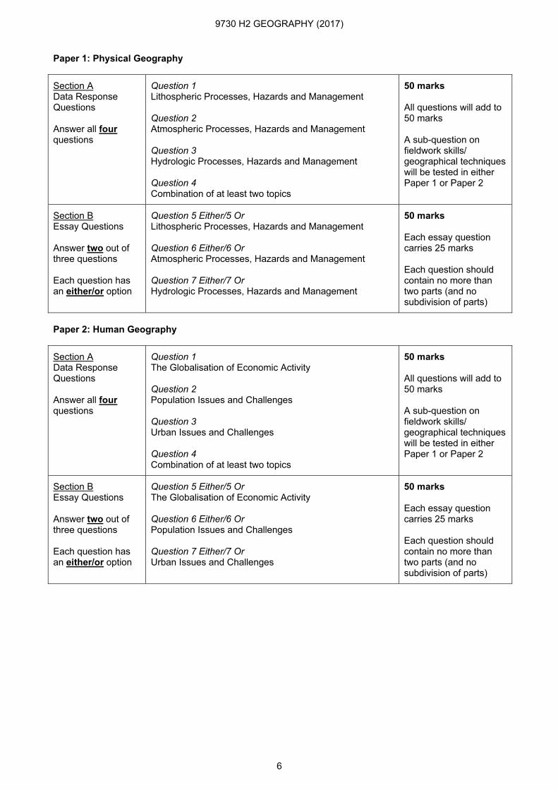
Paper 1: Physical Geography
Section A Data Response Questions Answer all four questions
Question 1
Lithospheric Processes, Hazards and Management Question 2
Atmospheric Processes, Hazards and Management Question 3
Hydrologic Processes, Hazards and Management Question 4
Combination of at least two topics
50 marks All questions will add to 50 marks A sub-question on fieldwork skills/ geographical techniques will be tested in either Paper 1 or Paper 2
Section B Essay Questions Answer two out of three questions Each question has an either/or option
Question 5 Either/5 Or
Lithospheric Processes, Hazards and Management Question 6 Either/6 Or
Atmospheric Processes, Hazards and Management Question 7 Either/7 Or
Hydrologic Processes, Hazards and Management
50 marks Each essay question carries 25 marks Each question should contain no more than two parts (and no subdivision of parts)
Paper 2: Human Geography
Section A Data Response Questions Answer all four questions
Question 1
The Globalisation of Economic Activity Question 2
Population Issues and Challenges Question 3
Urban Issues and Challenges Question 4
Combination of at least two topics
50 marks All questions will add to 50 marks A sub-question on fieldwork skills/ geographical techniques will be tested in either Paper 1 or Paper 2
Section B Essay Questions Answer two out of three questions Each question has an either/or option
Question 5 Either/5 Or
The Globalisation of Economic Activity Question 6 Either/6 Or
Population Issues and Challenges Question 7 Either/7 Or
Urban Issues and Challenges
50 marks Each essay question carries 25 marks Each question should contain no more than two parts (and no subdivision of parts)
9730 H2 GEOGRAPHY (2017)
7
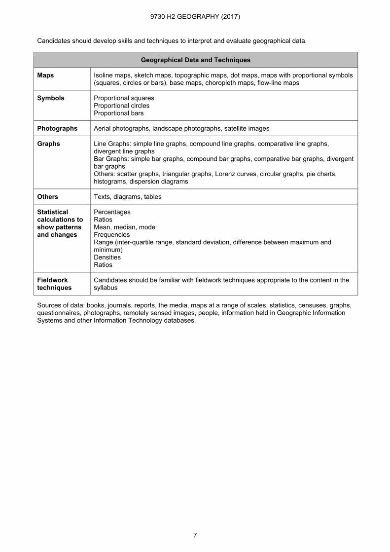
Candidates should develop skills and techniques to interpret and evaluate geographical data.
Geographical Data and Techniques
Maps Isoline maps, sketch maps, topographic maps, dot maps, maps with proportional symbols (squares, circles or bars), base maps, choropleth maps, flow-line maps
Symbols Proportional squares Proportional circles Proportional bars
Photographs Aerial photographs, landscape photographs, satellite images
Graphs Line Graphs: simple line graphs, compound line graphs, comparative line graphs, divergent line graphs Bar Graphs: simple bar graphs, compound bar graphs, comparative bar graphs, divergent bar graphs Others: scatter graphs, triangular graphs, Lorenz curves, circular graphs, pie charts, histograms, dispersion diagrams
Others Texts, diagrams, tables
Statistical calculations to show patterns and changes
Percentages Ratios Mean, median, mode Frequencies Range (inter-quartile range, standard deviation, difference between maximum and minimum) Densities Ratios
Fieldwork techniques
Candidates should be familiar with fieldwork techniques appropriate to the content in the syllabus
Sources of data: books, journals, reports, the media, maps at a range of scales, statistics, censuses, graphs, questionnaires, photographs, remotely sensed images, people, information held in Geographic Information Systems and other Information Technology databases.

9730 H2 GEOGRAPHY (2017)
8
SYLLABUS
Paper 1 Physical Geography Remarks
Topic 1: Lithospheric Processes, Hazards and Management 1. Plate Tectonics 2. Weathering 3. Mass Movement
Candidates are required to study three topics. These three topics should be studied at a variety of scales from global to local, so as to provide candidates with a broad overview and with some detailed exemplification. The processes, issues and management strategies should be illustrated with reference to relevant and contrasting examples from Less Developed Countries (LDCs) and Developed Countries (DCs) where applicable. It is frequently the case that the physical and human aspects of the subject are taught entirely separately. Such an approach is perfectly acceptable, but every opportunity should be taken to show the links between and within the physical and human parts of the syllabus. Attention should be given to the interaction of factors (economic, social, political and environmental), to the identification of characteristic processes and to how they change over space and time. It is essential that candidates study the topics in the context of actual places and that these are put into a global perspective. Wherever possible candidates should take examples from one particular region, rather than isolated examples from widely dispersed locations. Examples given are only for guidance.
Topic 2: Atmospheric Processes, Hazards and Management 1. The Earth’s Atmosphere and Atmospheric Processes 2. Climatic Zones of Tropical Africa and Asia 3. Adverse Weather Conditions 4. Climate Change and Responses
Topic 3: Hydrologic Processes, Hazards and Management 1. The Hydrologic Cycle 2. Channel Morphology and Processes in Drainage Basins 3. River Floods 4. Catchment Management
9730 H2 GEOGRAPHY (2017)
9
Topic: Lithospheric Processes, Hazards and Management
Content Learning Outcomes Main Concepts
Students will be able to:
1. Plate Tectonics
• Plate Tectonic Theory – Theory (e.g. structure of the earth, internal heating of the earth
and convection currents in the mantle) and evidence (e.g. seafloor spreading and paleomagnetism)
• Explain the theory of plate tectonics
• Plate tectonics
– Different types of plate boundaries: convergent, divergent and transform
• Discuss the different types of plate boundaries • Convergent boundary
• Divergent boundary
• Transform boundary
– The global distribution, formation and characteristics of the following:
○ Landforms: ocean ridges, fold mountains, deep sea trenches, island arcs, block mountains and rift valleys, volcanoes
○ Phenomena: earthquakes
• Describe the characteristics of tectonic landforms and explain how they are formed
• Explain how earthquakes occur
• Account for the global distribution of tectonic landforms and earthquakes
• Ocean ridge
• Fold mountain
• Deep sea trench
• Island arc
• Block mountain
• Rift valley
• Volcano
• Hotspot
• Earthquake
9730 H2 GEOGRAPHY (2017)
10
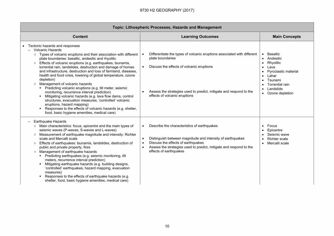
Topic: Lithospheric Processes, Hazards and Management
Content Learning Outcomes Main Concepts
• Tectonic hazards and responses – Volcanic Hazards
○ Types of volcanic eruptions and their association with different plate boundaries: basaltic, andesitic and rhyolitic
○ Effects of volcanic eruptions (e.g. earthquakes, tsunamis, torrential rain, landslides, destruction and damage of homes and infrastructure, destruction and loss of farmland, diseases, health and food crisis, lowering of global temperature, ozone depletion)
○ Management of volcanic hazards � Predicting volcanic eruptions (e.g. tilt meter, seismic
monitoring, recurrence interval prediction) � Mitigating volcanic hazards (e.g. lava flow dams, control
structures, evacuation measures, ‘controlled’ volcanic eruptions, hazard mapping)
� Responses to the effects of volcanic hazards (e.g. shelter, food, basic hygiene amenities, medical care)
• Differentiate the types of volcanic eruptions associated with different plate boundaries
• Discuss the effects of volcanic eruptions
• Assess the strategies used to predict, mitigate and respond to the effects of volcanic eruptions
• Basaltic
• Andesitic
• Rhyolitic
• Lava
• Pyroclastic material
• Lahar
• Tsunami
• Torrential rain
• Landslide
• Ozone depletion
– Earthquake Hazards
○ Main characteristics: focus, epicentre and the main types of seismic waves (P-waves, S-waves and L-waves)
○ Measurement of earthquake magnitude and intensity: Richter scale and Mercalli scale
○ Effects of earthquakes: tsunamis, landslides, destruction of public and private property, fires
○ Management of earthquake hazards � Predicting earthquakes (e.g. seismic monitoring, tilt
meters, recurrence interval prediction) � Mitigating earthquake hazards (e.g. building designs,
‘controlled’ earthquakes, hazard mapping, evacuation measures)
� Responses to the effects of earthquake hazards (e.g. shelter, food, basic hygiene amenities, medical care)
• Describe the characteristics of earthquakes
• Distinguish between magnitude and intensity of earthquakes
• Discuss the effects of earthquakes
• Assess the strategies used to predict, mitigate and respond to the effects of earthquakes
• Focus
• Epicentre
• Seismic wave
• Richter scale
• Mercalli scale
9730 H2 GEOGRAPHY (2017)
11
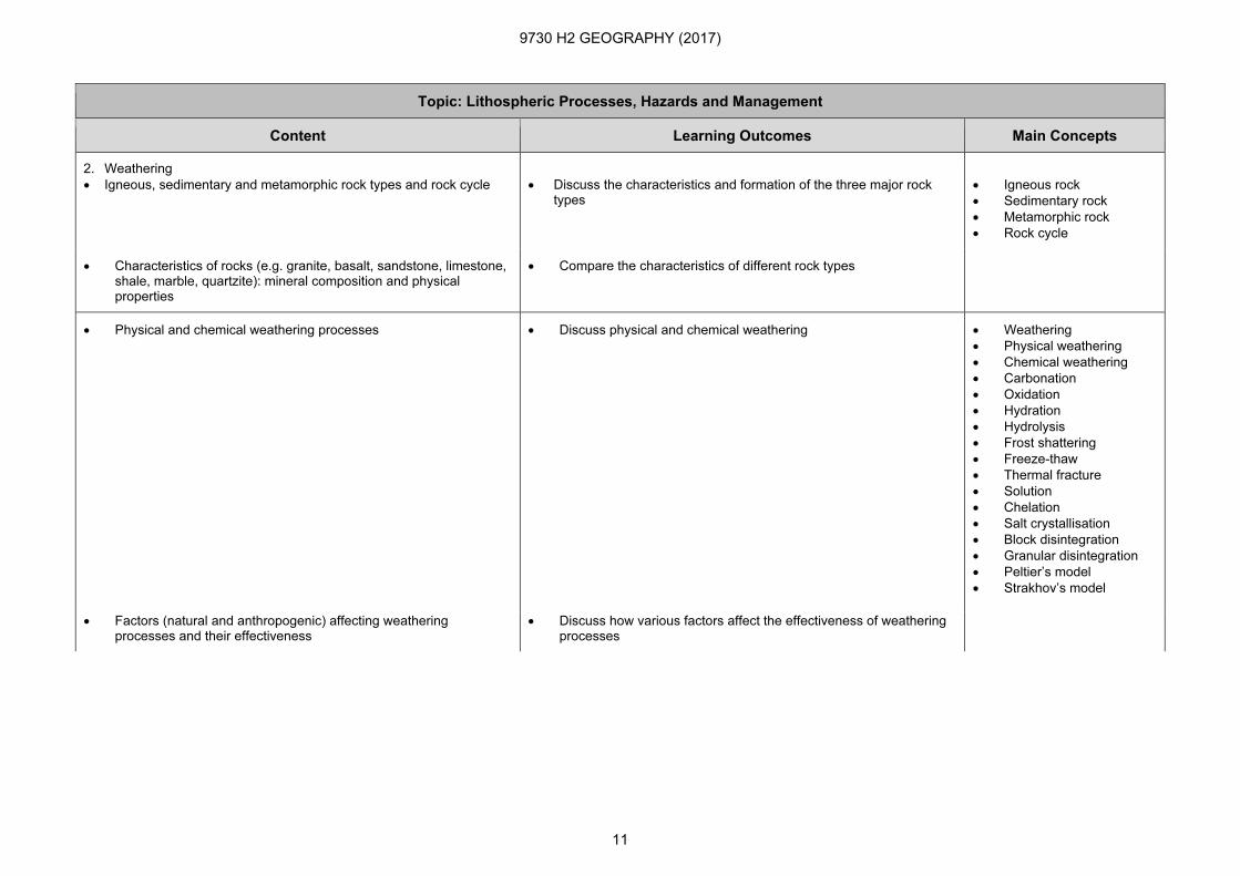
Topic: Lithospheric Processes, Hazards and Management
Content Learning Outcomes Main Concepts
2. Weathering
• Igneous, sedimentary and metamorphic rock types and rock cycle
• Discuss the characteristics and formation of the three major rock types
• Igneous rock
• Sedimentary rock
• Metamorphic rock
• Rock cycle
• Characteristics of rocks (e.g. granite, basalt, sandstone, limestone, shale, marble, quartzite): mineral composition and physical properties
• Compare the characteristics of different rock types
• Physical and chemical weathering processes • Discuss physical and chemical weathering • Weathering
• Physical weathering
• Chemical weathering
• Carbonation
• Oxidation
• Hydration
• Hydrolysis
• Frost shattering
• Freeze-thaw
• Thermal fracture
• Solution
• Chelation
• Salt crystallisation
• Block disintegration
• Granular disintegration
• Peltier’s model
• Strakhov’s model
• Factors (natural and anthropogenic) affecting weathering processes and their effectiveness
• Discuss how various factors affect the effectiveness of weathering processes
9730 H2 GEOGRAPHY (2017)
12
Topic: Lithospheric Processes, Hazards and Management
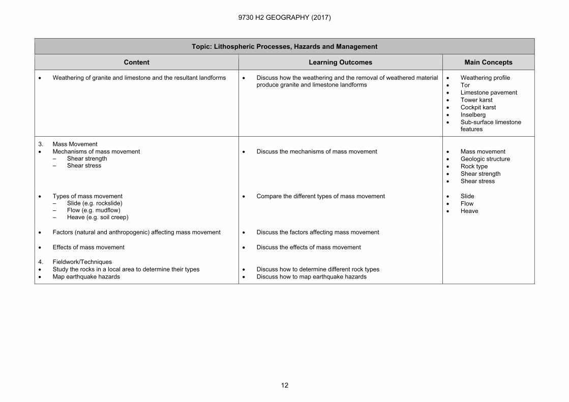
Content Learning Outcomes Main Concepts
• Weathering of granite and limestone and the resultant landforms
• Discuss how the weathering and the removal of weathered material produce granite and limestone landforms
• Weathering profile
• Tor
• Limestone pavement
• Tower karst
• Cockpit karst
• Inselberg
• Sub-surface limestone features
3. Mass Movement
• Mechanisms of mass movement – Shear strength – Shear stress
• Discuss the mechanisms of mass movement
• Mass movement
• Geologic structure
• Rock type
• Shear strength
• Shear stress
• Types of mass movement – Slide (e.g. rockslide) – Flow (e.g. mudflow) – Heave (e.g. soil creep)
• Compare the different types of mass movement • Slide
• Flow
• Heave
• Factors (natural and anthropogenic) affecting mass movement • Discuss the factors affecting mass movement
• Effects of mass movement • Discuss the effects of mass movement
4. Fieldwork/Techniques
• Study the rocks in a local area to determine their types
• Map earthquake hazards
• Discuss how to determine different rock types
• Discuss how to map earthquake hazards
9730 H2 GEOGRAPHY (2017)
13
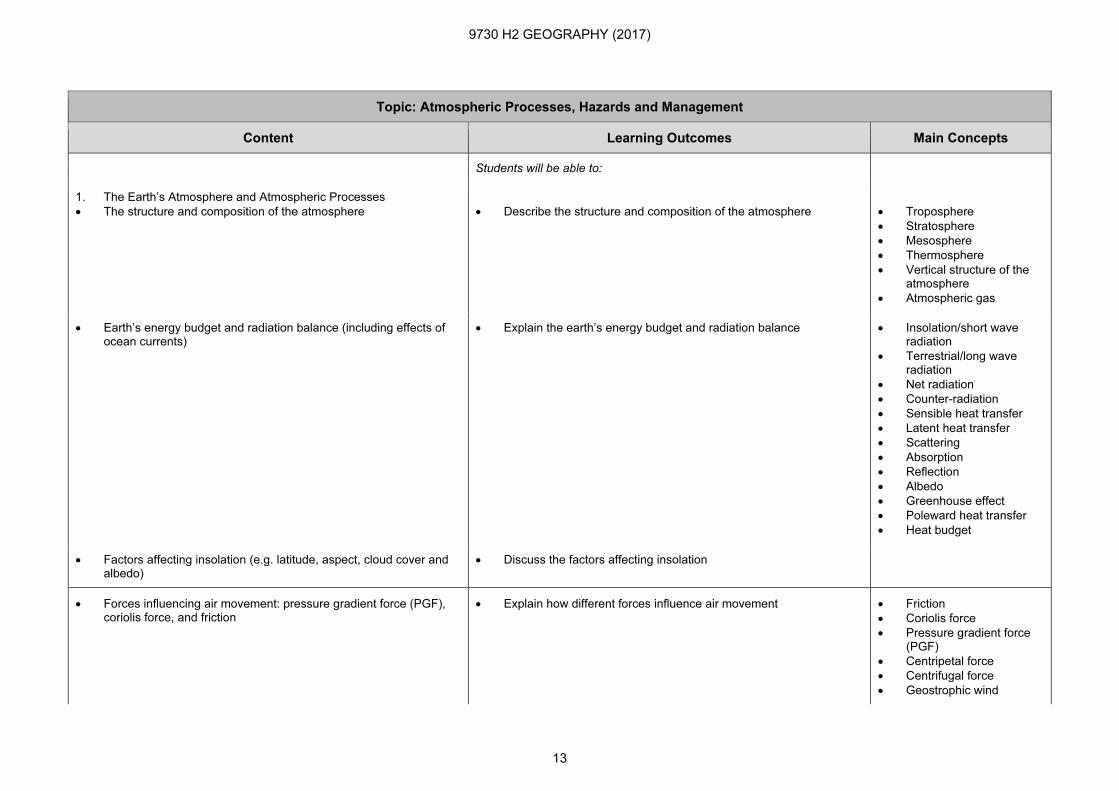
Topic: Atmospheric Processes, Hazards and Management
Content Learning Outcomes Main Concepts
Students will be able to:
1. The Earth’s Atmosphere and Atmospheric Processes
• The structure and composition of the atmosphere
• Describe the structure and composition of the atmosphere
• Troposphere
• Stratosphere
• Mesosphere
• Thermosphere
• Vertical structure of the atmosphere
• Atmospheric gas
• Earth’s energy budget and radiation balance (including effects of ocean currents)
• Explain the earth’s energy budget and radiation balance
• Insolation/short wave radiation
• Terrestrial/long wave radiation
• Net radiation
• Counter-radiation
• Sensible heat transfer
• Latent heat transfer
• Scattering
• Absorption
• Reflection
• Albedo
• Greenhouse effect
• Poleward heat transfer
• Heat budget
• Factors affecting insolation (e.g. latitude, aspect, cloud cover and albedo)
• Discuss the factors affecting insolation
• Forces influencing air movement: pressure gradient force (PGF), coriolis force, and friction
• Explain how different forces influence air movement
• Friction
• Coriolis force
• Pressure gradient force (PGF)
• Centripetal force
• Centrifugal force
• Geostrophic wind
9730 H2 GEOGRAPHY (2017)
14
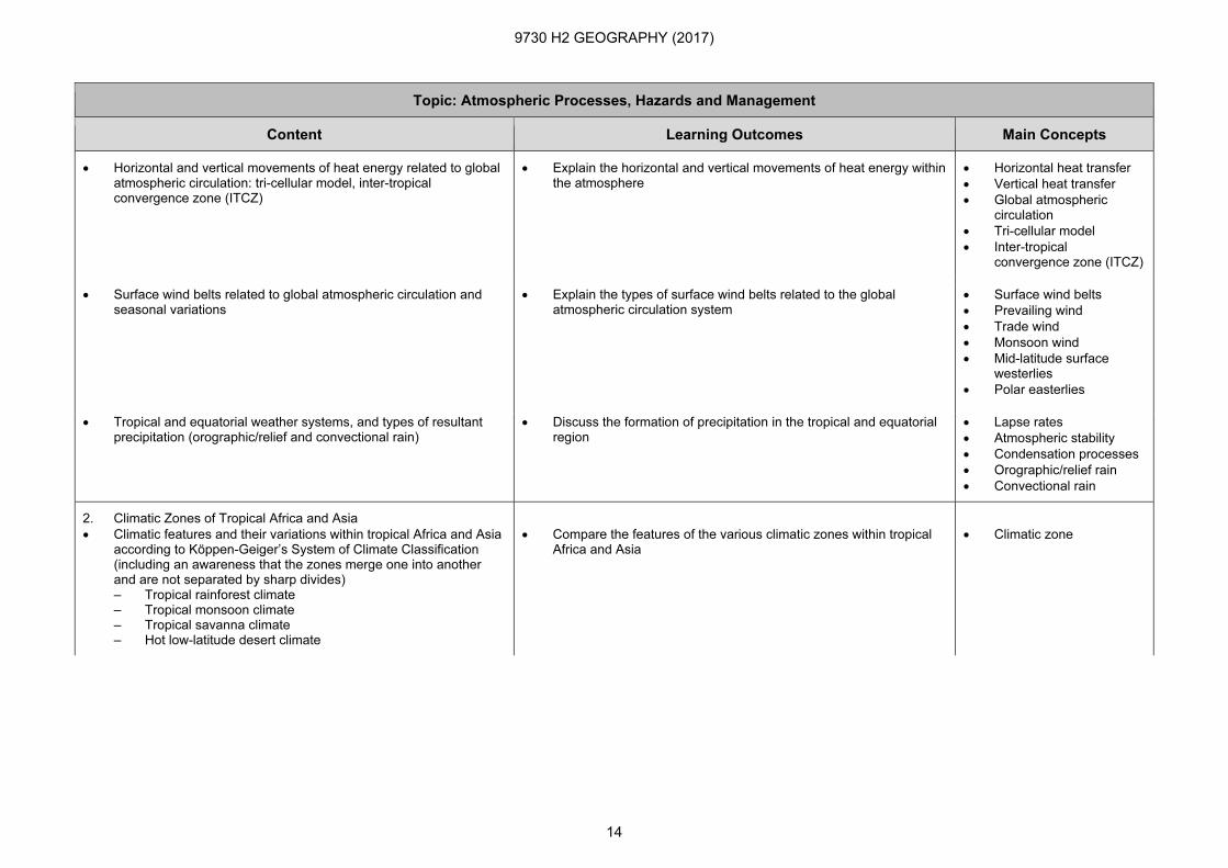
Topic: Atmospheric Processes, Hazards and Management
Content Learning Outcomes Main Concepts
• Horizontal and vertical movements of heat energy related to global atmospheric circulation: tri-cellular model, inter-tropical convergence zone (ITCZ)
• Explain the horizontal and vertical movements of heat energy within the atmosphere
• Horizontal heat transfer
• Vertical heat transfer
• Global atmospheric circulation
• Tri-cellular model
• Inter-tropical convergence zone (ITCZ)
• Surface wind belts related to global atmospheric circulation and seasonal variations
• Explain the types of surface wind belts related to the global atmospheric circulation system
• Surface wind belts
• Prevailing wind
• Trade wind
• Monsoon wind
• Mid-latitude surface westerlies
• Polar easterlies
• Tropical and equatorial weather systems, and types of resultant precipitation (orographic/relief and convectional rain)
• Discuss the formation of precipitation in the tropical and equatorial region
• Lapse rates
• Atmospheric stability
• Condensation processes
• Orographic/relief rain
• Convectional rain
2. Climatic Zones of Tropical Africa and Asia
• Climatic features and their variations within tropical Africa and Asia according to Köppen-Geiger’s System of Climate Classification (including an awareness that the zones merge one into another and are not separated by sharp divides) – Tropical rainforest climate – Tropical monsoon climate – Tropical savanna climate – Hot low-latitude desert climate
• Compare the features of the various climatic zones within tropical Africa and Asia
• Climatic zone
9730 H2 GEOGRAPHY (2017)
15
Topic: Atmospheric Processes, Hazards and Management
Content Learning Outcomes Main Concepts
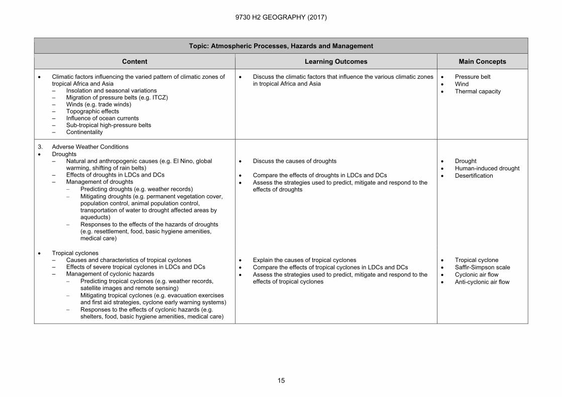
• Climatic factors influencing the varied pattern of climatic zones of tropical Africa and Asia – Insolation and seasonal variations – Migration of pressure belts (e.g. ITCZ) – Winds (e.g. trade winds) – Topographic effects – Influence of ocean currents – Sub-tropical high-pressure belts – Continentality
• Discuss the climatic factors that influence the various climatic zones in tropical Africa and Asia
• Pressure belt
• Wind
• Thermal capacity
3. Adverse Weather Conditions
• Droughts – Natural and anthropogenic causes (e.g. El Nino, global
warming, shifting of rain belts) – Effects of droughts in LDCs and DCs – Management of droughts
− Predicting droughts (e.g. weather records)
− Mitigating droughts (e.g. permanent vegetation cover, population control, animal population control, transportation of water to drought affected areas by aqueducts)
− Responses to the effects of the hazards of droughts (e.g. resettlement, food, basic hygiene amenities, medical care)
• Discuss the causes of droughts
• Compare the effects of droughts in LDCs and DCs
• Assess the strategies used to predict, mitigate and respond to the effects of droughts
• Drought
• Human-induced drought
• Desertification
• Tropical cyclones – Causes and characteristics of tropical cyclones – Effects of severe tropical cyclones in LDCs and DCs – Management of cyclonic hazards
− Predicting tropical cyclones (e.g. weather records, satellite images and remote sensing)
− Mitigating tropical cyclones (e.g. evacuation exercises and first aid strategies, cyclone early warning systems)
− Responses to the effects of cyclonic hazards (e.g. shelters, food, basic hygiene amenities, medical care)
• Explain the causes of tropical cyclones
• Compare the effects of tropical cyclones in LDCs and DCs
• Assess the strategies used to predict, mitigate and respond to the effects of tropical cyclones
• Tropical cyclone
• Saffir-Simpson scale
• Cyclonic air flow
• Anti-cyclonic air flow
9730 H2 GEOGRAPHY (2017)
16
Topic: Atmospheric Processes, Hazards and Management
Content Learning Outcomes Main Concepts
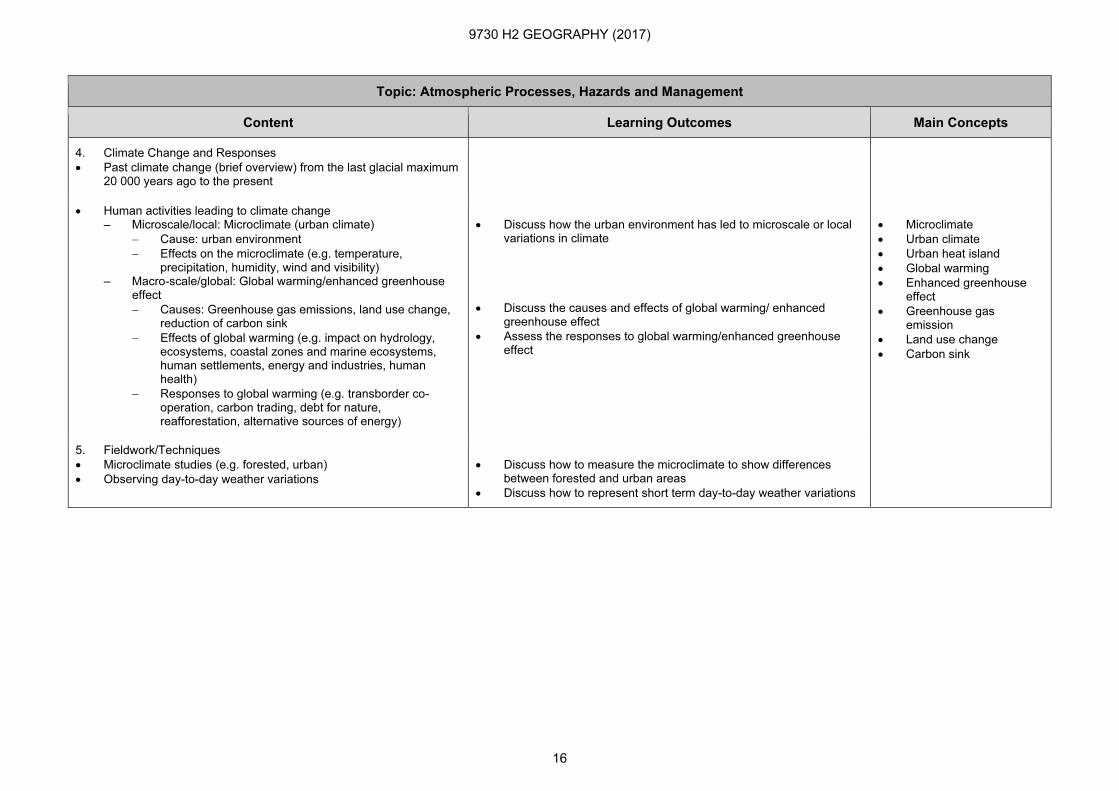
4. Climate Change and Responses
• Past climate change (brief overview) from the last glacial maximum 20 000 years ago to the present
• Human activities leading to climate change – Microscale/local: Microclimate (urban climate)
− Cause: urban environment
− Effects on the microclimate (e.g. temperature, precipitation, humidity, wind and visibility)
– Macro-scale/global: Global warming/enhanced greenhouse effect
− Causes: Greenhouse gas emissions, land use change, reduction of carbon sink
− Effects of global warming (e.g. impact on hydrology, ecosystems, coastal zones and marine ecosystems, human settlements, energy and industries, human health)
− Responses to global warming (e.g. transborder co-operation, carbon trading, debt for nature, reafforestation, alternative sources of energy)
• Discuss how the urban environment has led to microscale or local variations in climate
• Discuss the causes and effects of global warming/ enhanced greenhouse effect
• Assess the responses to global warming/enhanced greenhouse effect
• Microclimate
• Urban climate
• Urban heat island
• Global warming
• Enhanced greenhouse effect
• Greenhouse gas emission
• Land use change
• Carbon sink
5. Fieldwork/Techniques
• Microclimate studies (e.g. forested, urban)
• Observing day-to-day weather variations
• Discuss how to measure the microclimate to show differences between forested and urban areas
• Discuss how to represent short term day-to-day weather variations
9730 H2 GEOGRAPHY (2017)
17
Topic: Hydrologic Processes, Hazards and Management
Content Learning Outcomes Main Concepts
Students will be able to:
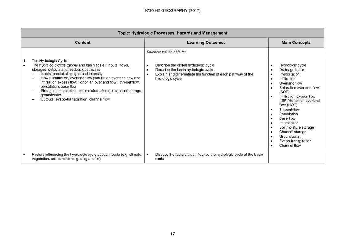
1. The Hydrologic Cycle
• The hydrologic cycle (global and basin scale): inputs, flows, storages, outputs and feedback pathways – Inputs: precipitation type and intensity – Flows: infiltration, overland flow (saturation overland flow and
infiltration excess flow/Hortonian overland flow), throughflow, percolation, base flow
– Storages: interception, soil moisture storage, channel storage, groundwater
– Outputs: evapo-transpiration, channel flow
• Describe the global hydrologic cycle
• Describe the basin hydrologic cycle
• Explain and differentiate the function of each pathway of the hydrologic cycle
• Hydrologic cycle
• Drainage basin
• Precipitation
• Infiltration
• Overland flow
• Saturation overland flow (SOF)
• Infiltration excess flow (IEF)/Hortonian overland flow (HOF)
• Throughflow
• Percolation
• Base flow
• Interception
• Soil moisture storage
• Channel storage
• Groundwater
• Evapo-transpiration
• Channel flow
• Factors influencing the hydrologic cycle at basin scale (e.g. climate, vegetation, soil conditions, geology, relief)
• Discuss the factors that influence the hydrologic cycle at the basin scale
9730 H2 GEOGRAPHY (2017)
18
Topic: Hydrologic Processes, Hazards and Management
Content Learning Outcomes Main Concepts
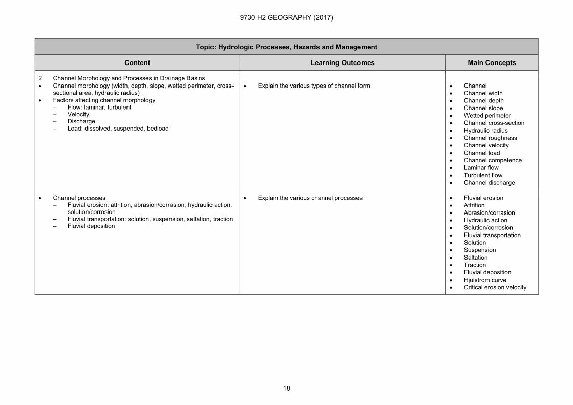
2. Channel Morphology and Processes in Drainage Basins
• Channel morphology (width, depth, slope, wetted perimeter, cross-sectional area, hydraulic radius)
• Factors affecting channel morphology – Flow: laminar, turbulent – Velocity – Discharge – Load: dissolved, suspended, bedload
• Explain the various types of channel form
• Channel
• Channel width
• Channel depth
• Channel slope
• Wetted perimeter
• Channel cross-section
• Hydraulic radius
• Channel roughness
• Channel velocity
• Channel load
• Channel competence
• Laminar flow
• Turbulent flow
• Channel discharge
• Channel processes – Fluvial erosion: attrition, abrasion/corrasion, hydraulic action,
solution/corrosion – Fluvial transportation: solution, suspension, saltation, traction – Fluvial deposition
• Explain the various channel processes • Fluvial erosion
• Attrition
• Abrasion/corrasion
• Hydraulic action
• Solution/corrosion
• Fluvial transportation
• Solution
• Suspension
• Saltation
• Traction
• Fluvial deposition
• Hjulstrom curve
• Critical erosion velocity

9730 H2 GEOGRAPHY (2017)
19
Topic: Hydrologic Processes, Hazards and Management
Content Learning Outcomes Main Concepts
• Channel pattern: characteristics and formation – Meandering: flow patterns and related features (point bars,
pools and riffles, slip-off slopes, river cliffs) – Braided (mid-channel bar, containing channel)
• Explain the meandering and braided channel patterns
• Compare the characteristics of meandering and braided channels
• Compare the conditions that lead to the formation of meandering and braided channels
• Channel pattern
• Meandering channel
• Braided channel
• Helicoidal flow
• Sinuosity index
• Point bar
• Pool and riffle
• Slip-off slope
• River cliff
• Mid-channel bar
• Containing channel
• Measurement of drainage density and stream order (Strahler)
• Explain how the characteristics of the drainage basin affect the drainage efficiency
• Drainage density
• Strahler’s stream order
• Bifurcation ratio
• Storm and annual hydrographs – Components – Factors influencing the storm and annual hydrograph (e.g.
geology, relief, basin shape, soil characteristics, rainfall events, vegetation cover, land use)
• Explain the components of the storm and annual hydrographs
• Describe the characteristics of the storm and annual hydrographs
• Discuss how different factors influence the storm and annual hydrographs
• Storm hydrograph
• Peak discharge
• Bankfull discharge
• Rising limb
• Falling limb
• Lag time
• Storm flow
• Baseflow
• Annual hydrograph
• River regime
3. River Floods
• Causes (natural and anthropogenic) of river flood
• Discuss the factors that cause river floods
• River flood
• Flood frequency
• Flood magnitude
• Recurrence interval
• Effects of river floods • Analyse the impact of river floods
9730 H2 GEOGRAPHY (2017)
20
Topic: Hydrologic Processes, Hazards and Management
Content Learning Outcomes Main Concepts
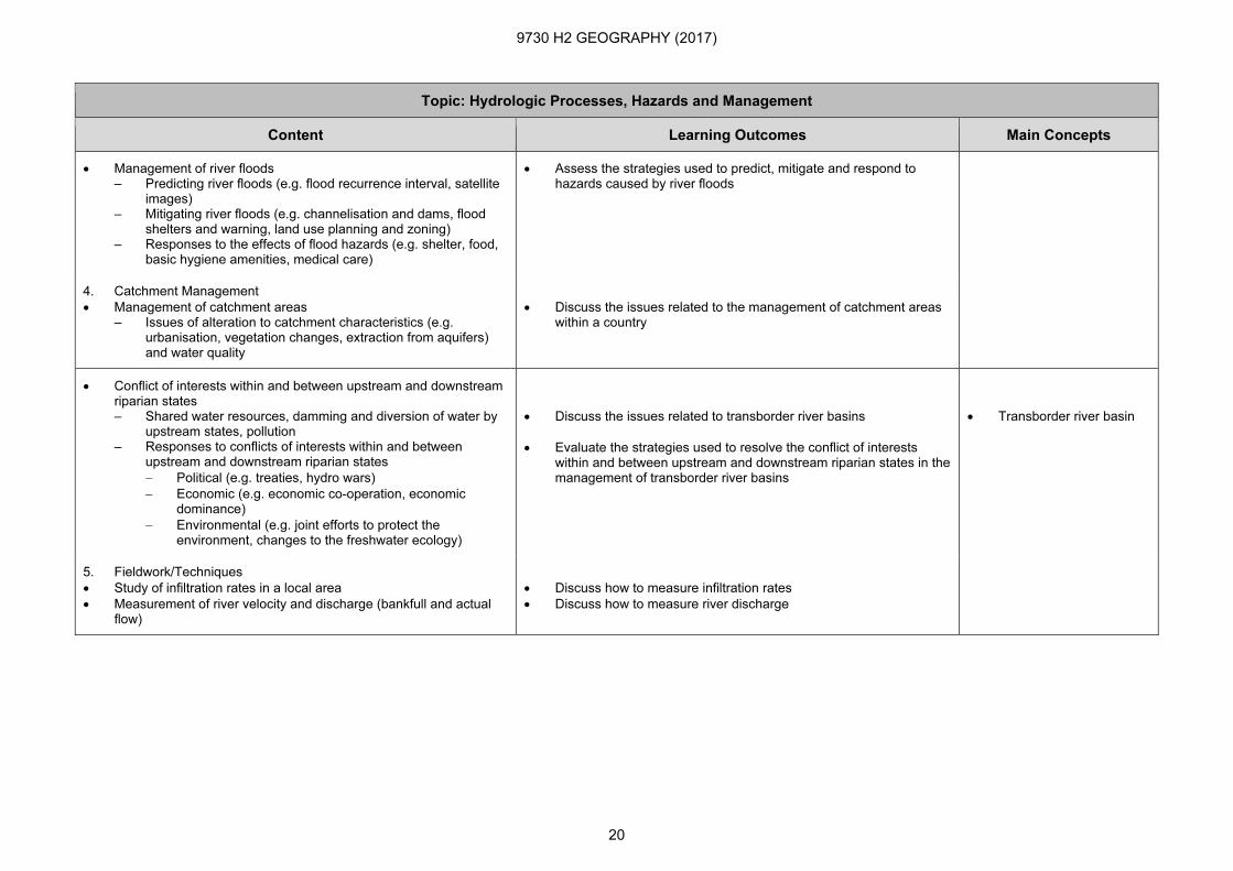
• Management of river floods – Predicting river floods (e.g. flood recurrence interval, satellite
images) – Mitigating river floods (e.g. channelisation and dams, flood
shelters and warning, land use planning and zoning) – Responses to the effects of flood hazards (e.g. shelter, food,
basic hygiene amenities, medical care)
• Assess the strategies used to predict, mitigate and respond to hazards caused by river floods
4. Catchment Management
• Management of catchment areas – Issues of alteration to catchment characteristics (e.g.
urbanisation, vegetation changes, extraction from aquifers) and water quality
• Discuss the issues related to the management of catchment areas within a country
• Conflict of interests within and between upstream and downstream riparian states – Shared water resources, damming and diversion of water by
upstream states, pollution – Responses to conflicts of interests within and between
upstream and downstream riparian states
− Political (e.g. treaties, hydro wars)
− Economic (e.g. economic co-operation, economic dominance)
− Environmental (e.g. joint efforts to protect the environment, changes to the freshwater ecology)
• Discuss the issues related to transborder river basins
• Evaluate the strategies used to resolve the conflict of interests within and between upstream and downstream riparian states in the management of transborder river basins
• Transborder river basin
5. Fieldwork/Techniques
• Study of infiltration rates in a local area
• Measurement of river velocity and discharge (bankfull and actual flow)
• Discuss how to measure infiltration rates
• Discuss how to measure river discharge
9730 H2 GEOGRAPHY (2017)
21
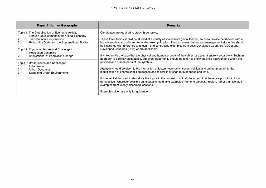
Paper 2 Human Geography Remarks
Topic 1: The Globalisation of Economic Activity 1. Uneven Development in the Global Economy 2. Transnational Corporations 3. Role of the State and the Supranational Bodies
Candidates are required to study three topics. These three topics should be studied at a variety of scales from global to local, so as to provide candidates with a broad overview and with some detailed exemplification. The processes, issues and management strategies should be illustrated with reference to relevant and contrasting examples from Less Developed Countries (LDCs) and Developed Countries (DCs) where applicable. It is frequently the case that the physical and human aspects of the subject are taught entirely separately. Such an approach is perfectly acceptable, but every opportunity should be taken to show the links between and within the physical and human parts of the syllabus. Attention should be given to the interaction of factors (economic, social, political and environmental), to the identification of characteristic processes and to how they change over space and time. It is essential that candidates study the topics in the context of actual places and that these are put into a global perspective. Wherever possible candidates should take examples from one particular region, rather than isolated examples from widely dispersed locations. Examples given are only for guidance.
Topic 2: Population Issues and Challenges 1. Population Dynamics 2. Implications of Population Change
Topic 3: Urban Issues and Challenges 1. Urbanisation 2. Urban Dynamics 3. Managing Urban Environments

9730 H2 GEOGRAPHY (2017)
22
Topic: Globalisation of Economic Activity
Content Learning Outcomes Main Concepts
Students will be able to:
1. Uneven Development in the Global Economy
• Globalisation – Characteristics (e.g. ‘shrinkage of distance’, spatial
division of the global economy, spatial interdependence, increased mobility and flexibility)
– Processes (e.g. changing structure of firms and technological change)
• Discuss the characteristics and processes of globalisation of economic activity
• Uneven development
• Globalisation
• ‘Shrinking world’
• Technological change
• Communications technology
• Information technology
• Global shift
• Uneven global distribution of economic activities (e.g. accentuation of regional disparities, convergence and divergence of economic activities)
• Discuss the global, regional and national variations in economic wealth
• Discuss the development gap
• Evaluate the usefulness of various indicators used to measure the level of development
• Development gap
• Less Developed Country (LDC)
• Developed Country (DC)
• Newly Industrialised Economy (NIE)
• Development indicator
• Human Development Index (HDI)
• New International Division of Labour – Causes of the emergence of the new international division
of labour (NIDL) – Impact of the emergence of NIDL on global economic
activities
• Account for the emergence of the new international division of labour
• Discuss how the new international division of labour impacts the global economy
• New International Division of Labour (NIDL)
• Comparative advantage
• Internationalisation and specialisation of economic activities
• De-skilling
• Re-skilling
• De-industrialisation
• Re-industrialisation

9730 H2 GEOGRAPHY (2017)
23
Topic: Globalisation of Economic Activity
Content Learning Outcomes Main Concepts
• Impact of Globalisation on the Service Sector – Rise in new service sectors: tertiary, quaternary (finance
and insurance) and quinary (education, government, health research and development)
– Locational trends in producer and consumer services (e.g. decentralisation)
– Internationalisation of service firms
• Discuss the impact of globalisation on the service sector
• Tertiary sector
• Quaternary sector
• Quinary sector
• Decentralisation
• Developing hub status
• Research and development industry
• Industrial location
2. Transnational Corporations
• Characteristics of Transnational Corporations (TNCs)
• Discuss the characteristics of TNCs
• Transnational Corporations (TNCs)
• The spatial organisation of TNCs’ activities including the spatial hierarchical distribution of headquarters, research and development centres, branch offices and branch plants
• Discuss the spatial organisation and structure of TNCs
• Discuss the command and control relationship between TNCs and the countries they operate in
• Job specialisation
• Flexible production
• Multi-skilled production
• Production chain
• Headquarter
• Regional headquarter
• Research and development centre
• Branch plant
• Branch office
• Outsourcing
• Small-medium enterprise
• Cross border investment
• Impact of TNCs on countries – Foreign direct investment and the influence on national
and regional economies – Social and environmental impact
• Discuss the impact of TNCs on the countries in which they operate
• Foreign Direct Investment (FDI)
• Inward investment
• Outward investment
• Case study of one TNC: spatial organisation, linkages and social, economic and environmental impact on the countries it operates in
• Discuss the spatial organisation of one TNC
• Discuss the impact of one TNC on the countries it operates in
9730 H2 GEOGRAPHY (2017)
24
Topic: Globalisation of Economic Activity
Content Learning Outcomes Main Concepts
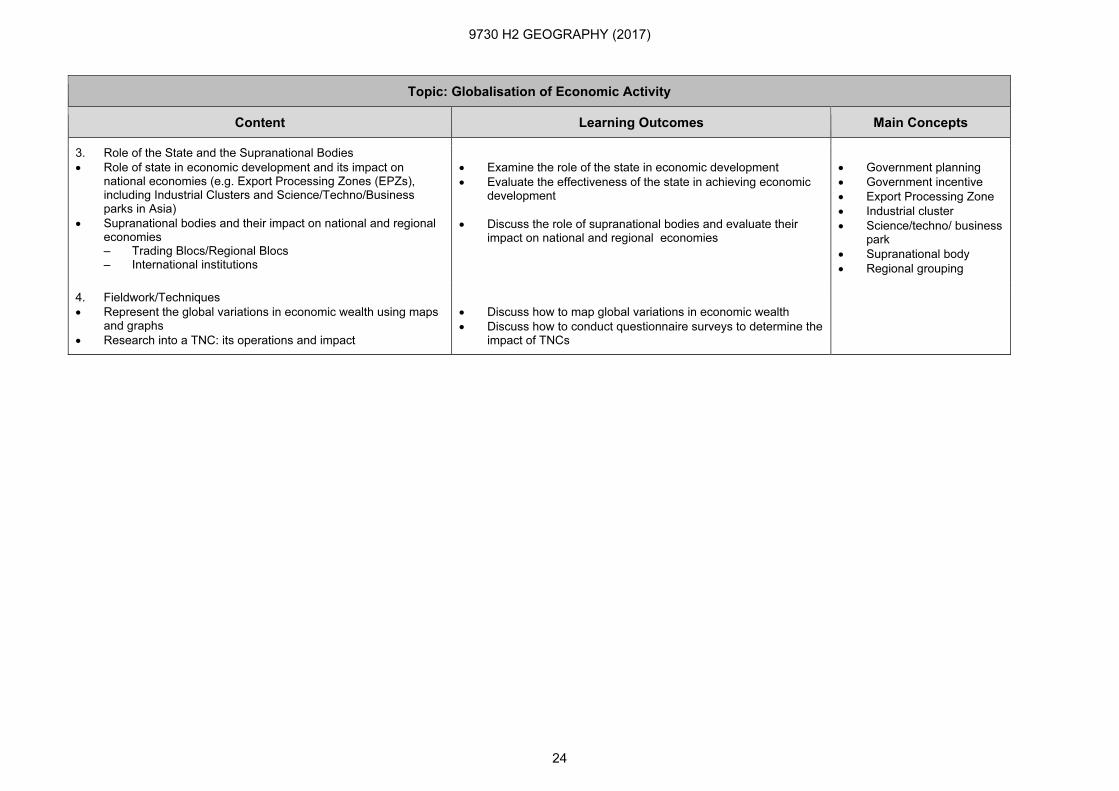
3. Role of the State and the Supranational Bodies
• Role of state in economic development and its impact on national economies (e.g. Export Processing Zones (EPZs), including Industrial Clusters and Science/Techno/Business parks in Asia)
• Supranational bodies and their impact on national and regional economies – Trading Blocs/Regional Blocs – International institutions
• Examine the role of the state in economic development
• Evaluate the effectiveness of the state in achieving economic development
• Discuss the role of supranational bodies and evaluate their impact on national and regional economies
• Government planning
• Government incentive
• Export Processing Zone
• Industrial cluster
• Science/techno/ business park
• Supranational body
• Regional grouping
4. Fieldwork/Techniques
• Represent the global variations in economic wealth using maps and graphs
• Research into a TNC: its operations and impact
• Discuss how to map global variations in economic wealth
• Discuss how to conduct questionnaire surveys to determine the impact of TNCs
9730 H2 GEOGRAPHY (2017)
25
Topic: Population Issues and Challenges
Content Learning Outcomes Main Concepts
Students will be able to:
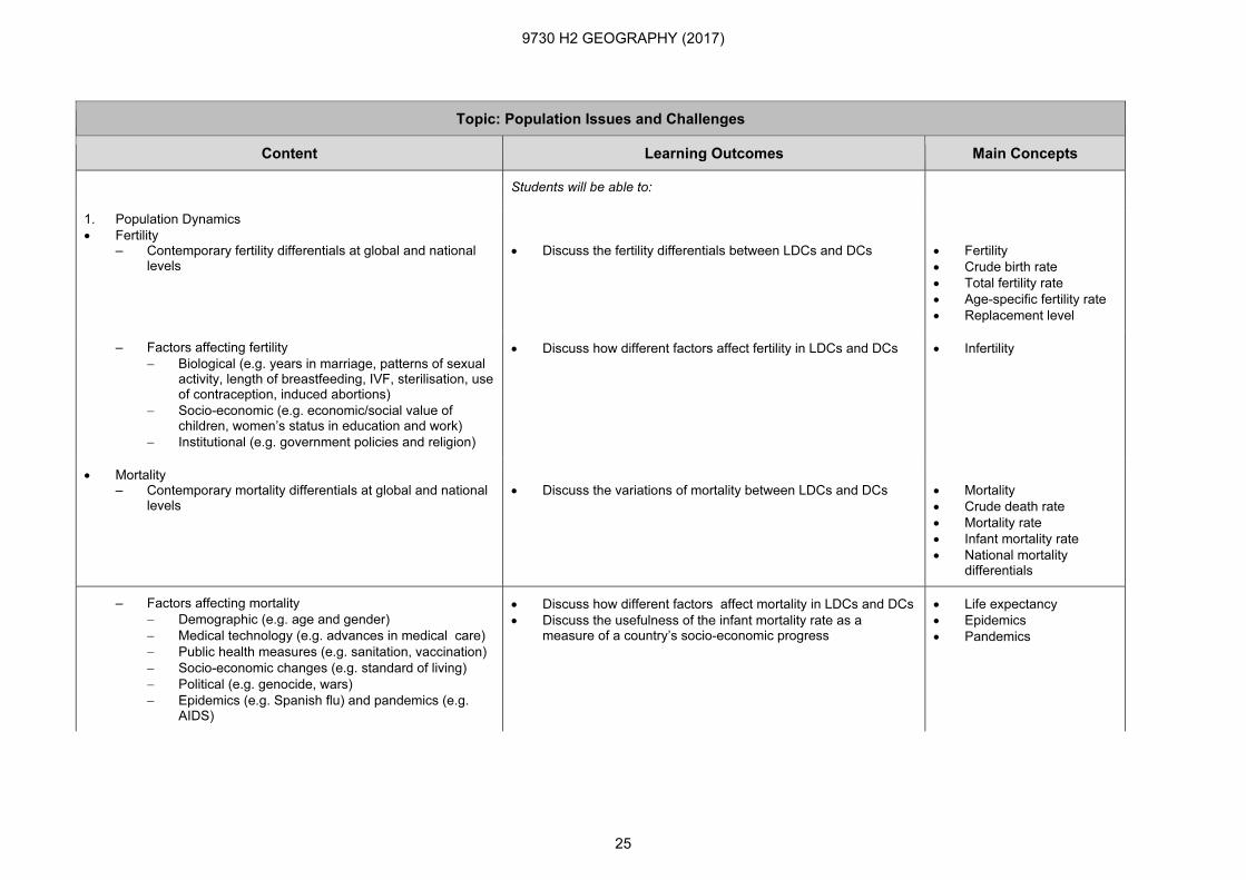
1. Population Dynamics
• Fertility – Contemporary fertility differentials at global and national
levels
• Discuss the fertility differentials between LDCs and DCs
• Fertility
• Crude birth rate
• Total fertility rate
• Age-specific fertility rate
• Replacement level
– Factors affecting fertility
− Biological (e.g. years in marriage, patterns of sexual activity, length of breastfeeding, IVF, sterilisation, use of contraception, induced abortions)
− Socio-economic (e.g. economic/social value of children, women’s status in education and work)
− Institutional (e.g. government policies and religion)
• Discuss how different factors affect fertility in LDCs and DCs
• Infertility
• Mortality – Contemporary mortality differentials at global and national
levels
• Discuss the variations of mortality between LDCs and DCs
• Mortality
• Crude death rate
• Mortality rate
• Infant mortality rate
• National mortality differentials
– Factors affecting mortality
− Demographic (e.g. age and gender)
− Medical technology (e.g. advances in medical care)
− Public health measures (e.g. sanitation, vaccination)
− Socio-economic changes (e.g. standard of living)
− Political (e.g. genocide, wars)
− Epidemics (e.g. Spanish flu) and pandemics (e.g. AIDS)
• Discuss how different factors affect mortality in LDCs and DCs
• Discuss the usefulness of the infant mortality rate as a measure of a country’s socio-economic progress
• Life expectancy
• Epidemics
• Pandemics

9730 H2 GEOGRAPHY (2017)
26
Topic: Population Issues and Challenges
Content Learning Outcomes Main Concepts
• Migration – Processes – Patterns – Consequences
• Discuss the causes, processes, patterns and results of recent migratory flows
• Assess the consequences of economic migratory flows in LDCs and DCs
• Migration
• Net migration
• Push-pull factors
• Mobility of labour/labour flows
• Origin
• Destination
• Internal migration
• Transnational movement
• Skilled labour
• Unskilled labour
2. Implications of Population Change
• Population Composition and Distribution – Overview of world population growth and future projections
in LDCs and DCs
− Population distribution across space and inequalities in distribution
− The need for and problems of population forecasting at national scale
• Discuss the reasons for changes and variations in population composition and distribution at the global scale
• Discuss the need for and problems of population forecasting at the national scale
• Population composition
• Population distribution
• Population density
– Interpretation of population pyramids
− The interpretation of population pyramids, and their relationship to growth rates
− The value and limitations of population pyramids in prediction
• Explain how to interpret population pyramids
• Discuss the value and limitations of population pyramids in predicting population change
• Population pyramid
• Population structure
• Dependency
• Dependency ratio
• Population Change and Planning – Population growth in relation to Demographic Transition
Model
− The Demographic Transition Model and its usefulness
• Discuss the various stages of the Demographic Transition Model
• Evaluate the usefulness of the Demographic Transition Model in understanding population change in LDCs and DCs
• Demographic Transition Model

9730 H2 GEOGRAPHY (2017)
27
Topic: Population Issues and Challenges
Content Learning Outcomes Main Concepts
– Anti-natal and pro-natal policies
− Role of governments in planning developments in the light of forecasts of population change (both in sheer numbers, population structure and in the composition of national populations)
− Population forecasting and government policies affecting population growth and their implications
• Discuss the issues of population dependency
• Evaluate the reasons for having pro or anti-natal policies
• Compare the effectiveness of pro or anti-natal policies in LDCs and DCs
• Anti-natal policy
• Pro-natal policy
• Population forecasting
• Population-resource Relationships – Concepts of carrying capacity, optimum population,
overpopulation and underpopulation
• Discuss the characteristics of overpopulation and underpopulation
• Carrying capacity
• Optimum population
• Overpopulation
• Underpopulation
– Population-resource theories, their origins and value
− Malthus
− Meadows and the Club of Rome
• Discuss the relationship between population growth and resource utilisation
• Evaluate the usefulness of theories on population growth and resource utilisation
• Malthus’ Theory
• Limits to Growth Theory
– Development and resource use
− Global variations in resource use
• Discuss resource use in LDCs and DCs
• Development
• Resource
• Resource use
• Renewable resource
• Non-renewable resource
• Resource depletion
• Resource management
• Ecological footprint
• Sustainable development
3. Fieldwork/Techniques
• Use of census data to look at dynamics of population change
• A research study using interviews to study migration flows and patterns
• Discuss how to make use of census data to construct the population structure of a place
• Discuss how to conduct semi-structured interviews to determine the causes of migration

9730 H2 GEOGRAPHY (2017)
28
Topic: Urban Issues and Challenges
Content Learning Outcomes Main Concepts
Students will be able to:
1. Urbanisation
• Overview of Urbanisation – Concept of urbanisation and its relationship to urban
growth
• Account for the initial and subsequent growth of urban settlements
• Discuss the relationship between urbanisation and urban growth
• Urbanisation
• Urban growth
– Sub-urbanisation, counter-urbanisation and re-urbanisation in the developed world
• Distinguish between counter-urbanisation, sub-urbanisation and re-urbanisation
• Discuss the economic and social factors resulting in sub-urbanisation and counter-urbanisation
• Evaluate the economic, social and environmental consequences of sub-urbanisation and counter-urbanisation
• Sub-urbanisation
• Counter-urbanisation
• Re-urbanisation
• Urban sprawl
– Urbanisation trends in LDCs and DCs • Compare the urbanisation trends in LDCs and DCs • Rates of urbanisation
• Characteristics and functions – Global cities – Primate cities
• Discuss the characteristics and functions of global cities
• Account for the emergence of megacities
• Compare the reasons for and consequences of the growth of primate cities in LDCs and DCs
• Compare the characteristics of global cities and primate cities
• Urban hierarchy
• Primacy
• Million city
• Megacity
• Global city
• Primate city
2. Urban Dynamics
• Competition for space (Bid Rent Theory) – Bid Rent Theory and the competition for space may be
studied in the context of urban zoning of economic activity and residential development
– Functional zoning: the changing nature of the central city and industrial location within urban settlements (manufacturing and services)
• Evaluate the usefulness of Bid Rent Theory in explaining urban zoning
• Compare and account for the different land use patterns in different urban areas
• Bid Rent Theory
• Distance-decay
• Urban density gradient
• Urban structure
• Functional zoning
• Commercial zone
• Residential zone
• Industrial zone
9730 H2 GEOGRAPHY (2017)
29
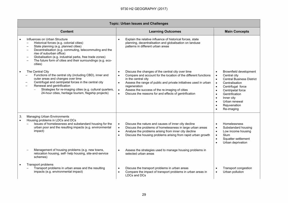
Topic: Urban Issues and Challenges
Content Learning Outcomes Main Concepts
• Influences on Urban Structure – Historical forces (e.g. colonial cities) – State planning (e.g. planned cities) – Decentralisation (e.g. commuting, telecommuting and the
rise of suburban office) – Globalisation (e.g. industrial parks, free trade zones) – The future form of cities and their surroundings (e.g. eco-
cities)
• Explain the relative influence of historical forces, state planning, decentralisation and globalisation on landuse patterns in different urban areas
• The Central City – Functions of the central city (including CBD), inner and
outer areas and changes over time – Centrifugal and centripetal forces in the central city – Renewal and gentrification
− Strategies for re-imaging cities (e.g. cultural quarters, 24-hour cities, heritage tourism, flagship projects)
• Discuss the changes of the central city over time
• Compare and account for the location of the different functions in the central city
• Assess the range of public and private initiatives used in urban regeneration
• Assess the success of the re-imaging of cities
• Discuss the reasons for and effects of gentrification
• Brownfield development
• Central city
• Central Business District
• Centralisation
• Centrifugal force
• Centripetal force
• Gentrification
• Inner city
• Urban renewal
• Rejuvenation
• Re-imaging
3. Managing Urban Environments
• Housing problems in LDCs and DCs – Issues of homelessness and substandard housing for the
urban poor and the resulting impacts (e.g. environmental impact)
• Discuss the nature and causes of inner city decline
• Discuss the problems of homelessness in large urban areas
• Analyse the problems arising from inner city decline
• Discuss the housing problems arising from rapid urban growth
• Homelessness
• Substandard housing
• Low income housing
• Slum
• Squatter settlement
• Urban deprivation
– Management of housing problems (e.g. new towns, relocation housing, self- help housing, site-and-service schemes)
• Assess the strategies used to manage housing problems in selected urban areas
• Transport problems – Transport problems in urban areas and the resulting
impacts (e.g. environmental impact)
• Discuss the transport problems in urban areas
• Compare the impact of transport problems in urban areas in LDCs and DCs
• Transport congestion
• Urban pollution
9730 H2 GEOGRAPHY (2017)
30
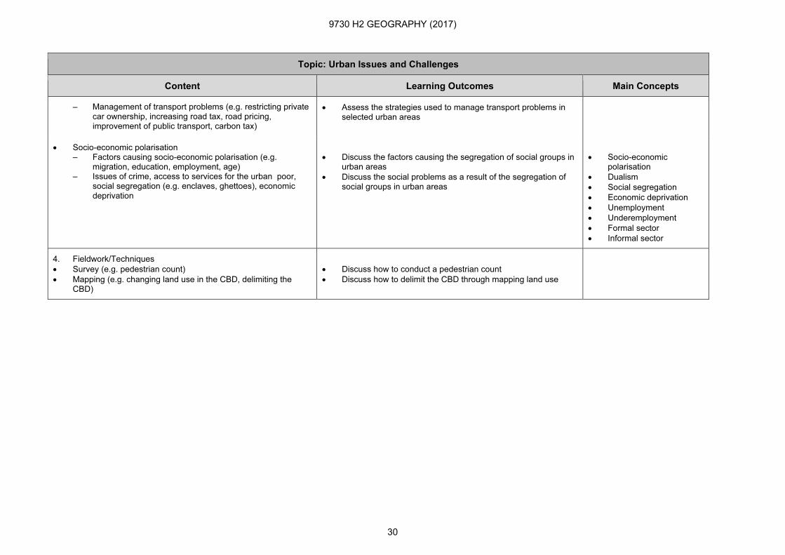
Topic: Urban Issues and Challenges
Content Learning Outcomes Main Concepts
– Management of transport problems (e.g. restricting private car ownership, increasing road tax, road pricing, improvement of public transport, carbon tax)
• Assess the strategies used to manage transport problems in selected urban areas
• Socio-economic polarisation – Factors causing socio-economic polarisation (e.g.
migration, education, employment, age) – Issues of crime, access to services for the urban poor,
social segregation (e.g. enclaves, ghettoes), economic deprivation
• Discuss the factors causing the segregation of social groups in urban areas
• Discuss the social problems as a result of the segregation of social groups in urban areas
• Socio-economic polarisation
• Dualism
• Social segregation
• Economic deprivation
• Unemployment
• Underemployment
• Formal sector
• Informal sector
4. Fieldwork/Techniques
• Survey (e.g. pedestrian count)
• Mapping (e.g. changing land use in the CBD, delimiting the CBD)
• Discuss how to conduct a pedestrian count
• Discuss how to delimit the CBD through mapping land use