9. oligocene to quaternary sedimentation processes on the ... · oligocene to quaternary...
TRANSCRIPT
Barker, P. R, Kennett, J. P., et al., 1990 Proceedings of the Ocean Drilling Program, Scientific Results, Vol. 113
9. OLIGOCENE TO QUATERNARY SEDIMENTATION PROCESSES ON THE ANTARCTIC CONTINENTAL MARGIN, ODP LEG 113, SITE 6931
Hannes Grobe,2 Dieter K. Fiitterer,2 and Volkhard Spie/33
ABSTRACT
Oligocene to Quaternary sediments were recovered from the Antarctic continental margin in the eastern Weddell Sea during ODP Leg 113 and Polarstern expedition ANT-VI. Clay mineral composition and grain size distribution patterns are useful for distinguishing sediments that have been transported by ocean currents from those that were ice-rafted. This, in turn, has assisted in providing insights about the changing late Paleogene to Neogene sedimentary environment as the cryosphere developed in Antarctica.
During the middle Oligocene, increasing glacial conditions on the continent are indicated by the presence of glauconite sands, that are interpreted to have formed on the shelf and then transported down the continental slope by advancing glaciers or as a result of sea-level lowering. The dominance of illite and a relatively high content of chlorite suggest predominantly physical weathering conditions on the continent. The high content of biogenic opal from the late Miocene to the late Pliocene resulted from increased upwelling processes at the continental margin due to increased wind strength related to global cooling. Partial melting of the ice-sheet occurred during an early Pliocene climate optimum as is shown by an increasing supply of predominantly current-derived sediment with a low mean grain size and peak values of smectite.
Primary productivity decreased at ~ 3 Ma due to the development of a permanent sea-ice cover close to the continent. Late Pleistocene sediments are characterized by planktonic foraminifers and biogenic opal, concentrated in distinct horizons reflecting climatic cycles. Isotopic analysis of AT. pachyderma produced a stratigraphy which resulted in a calculated sedimentation rate of 1 cm/k.y. during the Pleistocene. Primary productivity was highest during the last three interglacial maxima and decreased during glacial episodes as a result of increasing sea-ice coverage.
INTRODUCTION
Today the Southern Ocean, with its extensive ice shelves in the Weddell and Ross Seas, is one of the Earth's principal sources of oceanic bottom water and strongly influences global climate (Carmack, 1977; Foster and Middleton, 1980). Deposition of marine sediments record-via complex interactions between oceanography, continental ice, sea-ice, and biological processes-the global climatic cooling and the climatic cycles during Tertiary to recent times. Earlier investigations of surface and downcore Quaternary sediments indicate variations of pack-ice coverage, sedimentation processes, and extension and volume of the ice-sheet in response to climatic cycles (Anderson, 1972; Anderson et al., 1983; Fiitterer et al., 1988; Pudsey et al., 1988).
Sediment cores from the continental margin have provided detailed information about the history of the Antarctic continent because of their proximity to the ice shelves and a significant carbonate content in shallower waters above the CCD (carbonate compensation depth) (Elverhdi, 1981; Grobe, 1986a, b). In order to investigate the geologic history of global climatic cooling and Antarctic glaciation, drilling was carried out close to the continent, first in the Ross Sea (DSDP 28; Hayes, Frakes, et al., 1975) and, in 1987, in the Weddell Sea (ODP 113; Barker, Kennett, et al., 1988a, b).
On Leg 113, Site 693 was the first opportunity to investigate pre-Pleistocene sediments from the continental margin of the Weddell Sea. After two attempts to recover Cenozoic sediments
1 Barker, P. E, Kennett, J. P., et al., 1990. Proc. ODP, Sci. Results, 113: College Station, TX (Ocean Drilling Program).
2 Alfred Wegener Institute for Polar and Marine Research, D-2850 Bremerha-ven, Federal Republic of Germany.
3 University of Bremen, FB Geowissenschaften, D-2800 Bremen, Federal Republic of Germany.
in Wegener Canyon (Sites 691/692, Fig. 1, Table 1), Site 693 was drilled, recovering Pleistocene to Lower Cretaceous sediments. The sediment sequence is interrupted by a major hiatus of about 60 m.y. between the early Oligocene and the Albian. At Site 693 two holes were drilled: Hole 693A rotary cored, recovering Pleistocene to Albian sediments; and Hole 693B cored with the hydraulic piston corer and extended core barrel, recovering upper Miocene to Albian sediments. Samples of the Early Cretaceous (Lithologic Units VI and VII) were not included in these investigations.
-15°W "14° -13" -12°
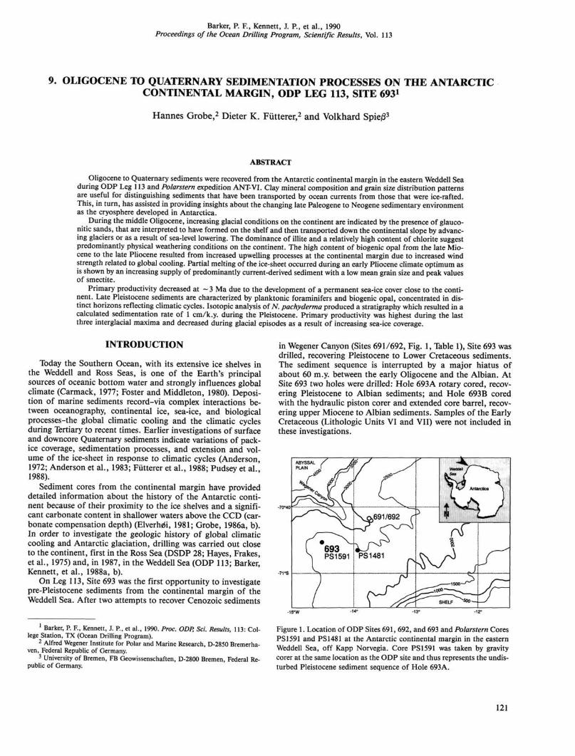
Figure 1. Location of ODP Sites 691, 692, and 693 and Polarstern Cores PS 1591 and PS 1481 at the Antarctic continental margin in the eastern Weddell Sea, off Kapp Norvegia. Core PS1591 was taken by gravity corer at the same location as the ODP site and thus represents the undisturbed Pleistocene sediment sequence of Hole 693A.
121
H. GROBE, D. K. FtJTTERER, V. SPIEB
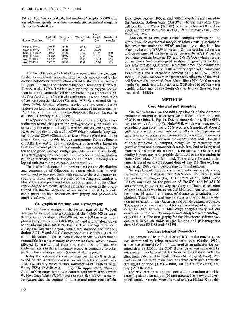
Table 1. Location, water depth, and number of samples at ODP sites and additional gravity cores from the Antarctic continental margin in the eastern Weddell Sea.
Hole or Core No.
ODP 113/691 ODP 113/692 ODP 113/693 A ODP 113/693B AWI PS1481 AWI PS1591
Latitude (s)
70°44' 70°43' 70°49' 70°49' 70°50' 70°50'
Longitude (w)
13°48' 13°49' 14°34' 14°34' 13°55' 14°33'
Water depth (m)
3035 2880 2359 2359 2505 2361
Cored length
(m)
0.05 30.00
483.9 169.3 10.80 12.20
Number c samples
— 310 216 154 153
The early Oligocene to Early Cretaceous hiatus has been correlated to worldwide unconformities which were created by increased bottom-water production related to the onset of Antarctic glaciation near the Eocene/Oligocene boundary (Kennett, Houtz, et al., 1975). This is also supported by oxygen isotope data from sub-Antarctic DSDP sites indicating a global cooling, the first formation of Antarctic continental ice, and production of sea-ice about 38 Ma ago (Kennett, 1978; Kennett and Shackleton, 1976). Glacial sediment fabrics and overconsolidation features on Leg 119 also indicate that grounded ice occupied the Prydz Bay area since the Eocene-Oligocene (Barron, Larson, et al., 1989; Hambrey et al., 1989).
In response to the Pleistocene climatic cycles, the Quaternary sediments record changes in the hydrographic regime which are caused by the retreat and advance of ice shelves, changing sea-ice cover, and the injection of NADW (North Atlantic Deep Water) into the CDW (Circumpolar Deep Water) (Grobe et al., in press). Recently, a stable isotope stratigraphy from sediments off Atka Bay (69°S, 180 km northeast of Site 693), based on both benthic and planktonic foraminifers, was correlated in detail to the global isotope stratigraphy (Mackensen et al., 1989). This stratigraphy has been used as a basis for the interpretation of the Quaternary sediment sequence at Site 693, the only lithological unit containing calcareous foraminifers.
The goal of this paper is to present data on the distribution and composition of Oligocene to recent glacio-marine sediments, and to interpret them with regard to the sedimentary response to the cryospheric evolution of the Antarctic continent. Due to the inadequate resolution and poor quality of the Oligo-cene-Neogene sediments, special emphasis is given to the undisturbed Pleistocene sequence which was recovered by gravity corer, providing high resolution stratigraphy and paleoceanographic information.
Geographical Settings and Hydrography The continental margin in the eastern part of the Weddell
Sea can be divided into a continental shelf (500-600 m water depth), an upper slope (500-1800 m), an - 2 0 0 km wide, morphologically flat terrace (1800-3000 m), and a lower slope down to the abyssal plain (4500 m, Fig. 1). The investigation area is cut by the Wegener Canyon, which was mapped and dredged during ANT-IV and ANT-V expeditions of Polarstern (Fiitterer et al., this volume). This canyon is close to Site 693 and thus is responsible for a sedimentary environment there, which is more affected by gravitational transport, turbidites, hiatuses, and spill-over facies in the sedimentary record as compared to other parts of the mid-slope bench (Grobe et al., in press).
Today the sedimentary environment on the shelf is determined by the Antarctic coastal current which transports very cold, low salinity water masses southwestward (Eastern Shelf Water, ESW; Foldvik et al., 1985). The upper slope, down to about 2000 m water depth, is in contact with the relatively warm Weddell Deep Water (WDW) and the modified WDW. In the investigation area the continental terrace and upper parts of the
lower slope between 2000 m and 4000 m depth are influenced by the Antarctic Bottom Water (AABW), whereas the colder Weddell Sea Bottom Water (WSBW) is found below 4000 m (Car-mack and Foster, 1977; Weiss et al., 1979; Foldvik et al., 1985; Osterhus, 1987).
Analysis of 41 box core surface samples between 5° and 20°W from the continental margin revealed virtually Carbonate-free sediments under the WDW, and at abyssal depths below 4000 m where the WSBW is present. On the continental terrace and upper parts of the lower slope, covered by AABW, surface sediments contain between 1% and 5% CaC03 (Mackensen et al., in press). Sedimentological analyses of gravity cores from this area revealed Quaternary sediments from the continental terrace between 1800 and 3000 m water depth with calcareous foraminifers and a carbonate content of up to 30% (Grobe, 1986b). Calcium carbonate in Quaternary sediments of the Weddell Sea was also reported from Maud Rise (2400-3500 m water depth; Gersonde et al., in press) and ODP Site 696 (650 m water depth), drilled east of the South Orkney Islands (Barker, Kennett, et al., 1988b).
METHODS
Core Material and Sampling Site 693 is located on the mid-slope bench of the Antarctic
continental margin in the eastern Weddell Sea, in a water depth of 2359 m (Table 1, Fig. 1). Due to rotary drilling, Hole 693A has a recovery of only 44%. Hole 693B, which was recovered by extended piston corer, has a 55% recovery. Samples of about 5 cm3 were taken at a mean interval of 50 cm. Drilling-induced sand layering appears, and downwashed Pleistocene sediments were found in several horizons throughout both holes. Because of these problems, 50 samples, recognized by extremely high gravel content and downwashed foraminifers, had to be rejected from the 576 samples taken (Table 1). Because core recovery and quality is poor, any stratigraphic definition or interpretation in Hole 693A below 130 m is limited. The stratigraphy used in this paper is based on the shipboard data of Leg 113 (Barker, Kennett, et al., 1988b) and paleomagnetic investigations.
We supplement the upper sequence with two gravity cores, recovered during Polarstern cruise ANT-VI/3 in 1987/88 from the continental margin (Fig. 1) (Fiitterer et al., 1988). Core PS 1591 was taken on the position of Site 693, and PS 1481 20 km east of it, closer to the Wegener Canyon. The exact selection of core locations was based on 3.5 kHz-sediment echo-soundings to avoid sampling in areas of slumps or unsuitable morphology. These additional gravity cores allowed a high-resolution investigation of the Quaternary carbonate bearing sequence. The gravity cores were sampled for sedimentological and paleomagnetic (107 samples, PS 1481 only) analyses every 7-8 cm downcore. A total of 833 samples were analyzed sedimentologi-cally (Table 1). The stratigraphy for the Pleistocene sediment sequence is based on stable oxygen isotope and paleomagnetic data of Cores PS4181 and PS 1591.
Sedimentological Parameters The content of ice-rafted debris (IRD) in the gravity cores
was determined by using standard techniques (Grobe, 1987), percentage of gravel (> 1 mm) was used as an indicator for ice-rafted debris (IRD) in the ODP Holes. Sand was separated by wet sieving, the clay and silt fractions by decantation with settling times calculated by Stokes' Law (Atterberg Method). Percentages of the three main fractions were calculated from the dry weight of sand (0.063-2 mm), silt (0.002-0.063 mm) and clay (< 0.002 mm).
The clay fraction was flocculated with magnesium chloride, centrifuged, and an aliquot (20 mg) mounted as a texturally oriented sample. Samples were analyzed using a Philips X-ray dif-
122
OLIGOCENE TO QUATERNARY SEDIMENTATION PROCESSES, SITE 693
fractometer (PW1050/25) with automatic divergence slit at 40 kV and 40 mA using a cobalt tube. A scan was performed from 2° 20 to 40° 20 with a scanning speed of 0.02° 20/s. Peak areas were measured by integration. The relative percentages of smectite, illite, and chlorite were determined. Kaolinite is absent or only a minor component of the clay fraction in most samples, and was therefore not included in the calculations.
For analysis of water in the gravity cores, 2 cm3 samples were freeze-dried, weighed, and then pulverized in a planet mill. The carbon-content was determined with a LECO CS 125 Carbon-Sulfur Determinator by combustion of the bulk sediment for total carbon, and by dissolution of the carbonate in hydrochloric acid and combustion of the residue for organic carbon. Calcium carbonate was calculated as a percentage by weight of the bulk dry sediment. The downcore distribution of radiolaria was measured in all samples by counting particles in the coarse fraction (> 0.063 mm) according to the method of Sarnthein (1971). The biogenic content in the finer grain-size fractions of the gravity cores was estimated by smear-slide investigation (Grobe and Kuhn, 1987).
Paleomagnetic samples in Core PS 1481 were taken from a split-half surface of the sediment core in boxes of 7 cm3. A sampling interval of 10 cm was chosen for high resolution studies. Paleomagnetic directions and magnetization intensities were measured with a cryogenic magnetometer (Cryogenic Consultant, Model GM 400). Natural remanent magnetization (NRM) was measured on each sample which was then taken through a systematic alternating field demagnetization treatment (Schoenstedt GSD-1 single axis demagnetizer) involving —10 steps on each sample up to an alternating field strength of at least 80 m l Cores 113-693A-2R through -5R were also measured this way.
The stable isotope measurements in Core PS 1481 were made on planktonic foraminiferal tests of sinistrally coiled Neogloboquadrina pachyderma. The foraminifers were dissolved in 100% orthophosphoric acid at 70°C using an automatic 46-position carbonate preparation device (Finnigan MAT), which is connected on-line to a Finnigan MAT 251 mass spectrometer. The amount of carbonate used for one measurement varied between 40 and 60 mg. This corresponds to 2-6 specimens of N. pachyderma in the 125-250 /im fraction used for picking the tests.
All measurements were carried out against a laboratory standard (natural well gas) which has been calibrated to the VPDB-scale (Vienna Peedee Belemnite) using the IAEA (International Atomic Energy Agency) distributed reference sample NBS 19 (National Bureau of Standards) (Hut, 1987). The linearity and proportionality of the mass spectrometer with respect to the VPDB-scale was checked using the NBS 18 and NBS 20 standards. Standard deviations of measurements are <0.06%o for 12C/13C and <0.09%0 for 1 6 0/ 1 8 0 . Data are corrected for mass spectra effects according to Craig (1957), and isotope ratios are given in 5-notation vs. VPDB.
RESULTS Unit I (0-12.2 mbsf) is a foraminifer bearing clayey to silty
mud of Pleistocene age. Unit I was also recovered undisturbed by gravity corer (PS1481, Fig. 4; PS1591, Fig. 6) in addition to Site 693. The carbonate content ranges between 0% and 10%, mainly consisting of N. pachyderma. Silica is concentrated in distinct horizons which have concurrently low carbonate content. The siliceous particles consist of radiolarians, diatoms, and silicoflagellates. Variations in sand content are mainly controlled by the amount of foraminifers; detrital sand is only up to 3% of the bulk sample. The clay mineral composition is dominated by illite but also exhibits significant variations of smectite. Gravel is common throughout.
Unit II (12.2-31.4 mbsf) of late Pliocene to early Pleistocene age consists of a clayey mud with biogenic components only as
traces. The sand content is very low, silt and clay values are both between 40% and 60% with increasing clay values downcore. The distribution of clay minerals is similar to that of Unit I, though the boundary between Unit I and Unit II is characterized by minimum values of smectite.
Unit IIIA (31.4-243.9 mbsf) is of late Miocene to late Pliocene age and characterized by a significant content of silica throughout. The siliceous components consist of diatoms, radiolarians, and silicoflagellates. The amount of silica is about ten times higher than in the Pleistocene silica-bearing horizons. The sand content is low, with an exception in the lowermost part (220-240 mbsf), where sand reaches values of up to 30%. Illite shows minimum values at ~ 100-130 mbsf due to an increase of smectite and chlorite downcore. Illite again becomes the dominant clay mineral below 150 mbsf. In the lowermost part of Unit IIIA at -240 mbsf a peak value of chlorite correlates with a high content of gravel. No sedimentological information is available between 175 and 225 mbsf due to poor recovery.
Unit IIIB (243.9-255.1 mbsf) within the late Miocene is distinguished by the presence of nannofossils (Barker, Kennett, et al., 1988b). The amount of sand, silt, and clay is similar to Unit IIIA. Clay minerals show minimum values of chlorite.
Unit IIIC sediments (255.1-325.8 mbsf), ranging from late Oligocene to late Miocene, are similar to Unit IIIA. Diatom content ranges from 15% to 60%, and the content of radiolarians is lower than in Unit IIIA. Grain size distribution shows low sand content and silt values around 60%. Smectite and chlorite decrease downcore. A significant gravel content of up to 3% occurs throughout the unit.
Unit IV (325.8-345.1 mbsf), within the late Oligocene, consists of four cycles of a muddy nannofossil ooze alternating with diatom-bearing silty mud and clayey mud. The grain size distribution is similar to Unit IIIC. Smectite generally is high (30%) and a slight increase of chlorite continues downcore.
Unit V (345.1-397.8 mbsf) is defined between the lower/upper Oligocene boundary and a hiatus within the lower Oligocene followed by Cretaceous sediments. Diatom silty mud and diatom clayey mud are the dominant lithologies. In addition pebbles, which are considered to be ice-rafted in all cores of the units described above, were observed (Barker, Kennett, et al., 1988b). A remarkably high content of well sorted glauconitic sand of up to 25% characterizes Unit V. The amount of silt remains constant, but clay decreases to 20%. Chlorite still increases to a depth of 390 mbsf and smectite increases within the unit from about 15% to 35%.
DISCUSSION
Oligocene-Miocene (35-5 Ma) The oldest sampled sequence above the Early Cretaceous to
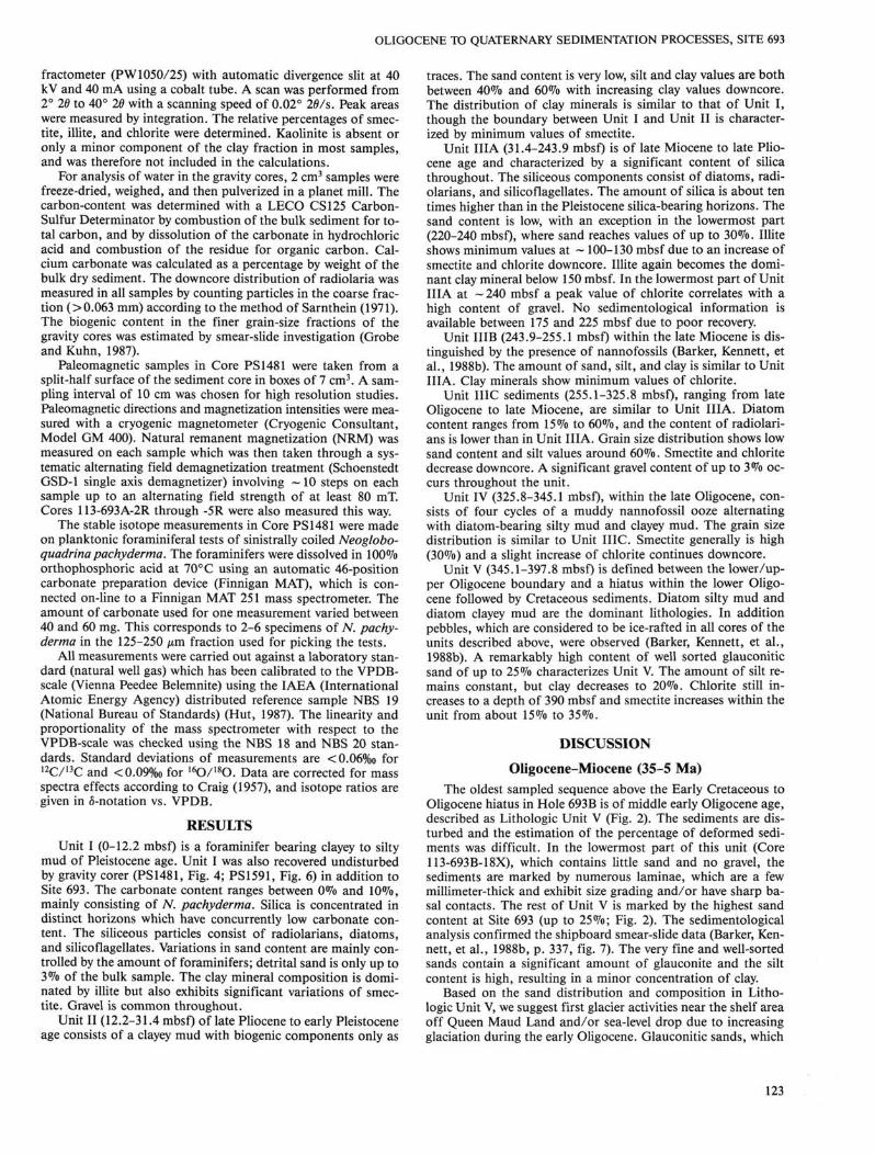
Oligocene hiatus in Hole 693B is of middle early Oligocene age, described as Lithologic Unit V (Fig. 2). The sediments are disturbed and the estimation of the percentage of deformed sediments was difficult. In the lowermost part of this unit (Core 113-693B-18X), which contains little sand and no gravel, the sediments are marked by numerous laminae, which are a few millimeter-thick and exhibit size grading and/or have sharp basal contacts. The rest of Unit V is marked by the highest sand content at Site 693 (up to 25%; Fig. 2). The sedimentological analysis confirmed the shipboard smear-slide data (Barker, Kennett, et al., 1988b, p. 337, fig. 7). The very fine and well-sorted sands contain a significant amount of glauconite and the silt content is high, resulting in a minor concentration of clay.
Based on the sand distribution and composition in Lithologic Unit V, we suggest first glacier activities near the shelf area off Queen Maud Land and/or sea-level drop due to increasing glaciation during the early Oligocene. Glauconitic sands, which
123

H. GROBE, D. K. FUTTERER, V. SPIEB
200
250 -
CO CO o> CD
o X to -O E
Q
300 -
350 _
• | % % % j i Q Nannofossils Radiolaria Gravel ^ § 0 40 0 5 3 0
1 1 ' ■ -
% Sand/Silt/Clay Smectite/lllite/Chlorite
400 -J Figure 2. Distribution of sedimentological parameters in Hole 693B, based on counts of radiolarians, determination of the percentage of sand, silt, and clay and clay mineral analysis.
can most likely be interpreted as shelf sediments, were transported down the upper steep continental slope, possibly sorted, and deposited on the slope bench. The accompanying occurrence of gravel, interpreted as glacier derived, is indicative of first iceberg activities. The graded laminae can be explained as small distal turbidites due to increased transport by sediment gravity flow on the upper continental slope, probably triggered by glacier advances. Overconsolidated glacial sediments at ODP Sites 739 and 742 off Prydz Bay also indicate some cryospheric development on east Antarctica during the early Oligocene (Ham-breyet al., 1989).
Beginning with the Oligocene, not only weathering conditions but increasingly the amount of ice-rafted debris changes the composition of sediments supplied to the sea. The composition of the clay mineral assemblage is not only a result of the source area and weathering processes, but is also influenced by selective transport and deposition (Singer, 1984). Grain size sorting during transport may thus represent a significant factor in clay mineral composition and became more important than the climatically controlled change of weathering conditions. Since the development of Antarctic glaciation, physical weathering conditions on the continent have become dominant and changes of clay mineral composition in the glacio-marine sediments are mostly controlled by ocean current activities.
Illite, as the major clay component in the lower Oligocene to Neogene sediments, suggests weathering conditions controlled by a cool and arid climate (Barker, Kennett, et al., 1988a, b). The higher chlorite content in Unit V, compared to other units,
also indicates increased physical weathering processes on the continent due to climatic deterioration. During the initial glaciation of Antarctica, the main process for delivering sediments to the sea would have been ice rafting of older, previously weathered sediments from the continent. As a result of increased erosion by ice and meltwater, the proportion of current-derived sediments may have increased and the composition of the fine fraction in the lower part of Unit V changed to higher values of smectite (Fig. 2). Smectite, as the smallest clay mineral, remains in suspension longer and thus is transported further than other clay minerals. It is useful as an indicator for a sedimentary environment dominated by current-derived detritus in this area (Grobe, 1986b). Both chlorite and smectite decrease toward the top of Unit V and may indicate the decreasing amount of old continental sediments due to glacial erosion within the middle Oligocene.
The chlorite and also the basaltic dropstones found at Site 693 presumably were not derived from the West Antarctic (Barker, Kennett, et al., 1988b), because icebergs, calving from the West Antarctic, would be unlikely to reach this location in the Eastern Weddell Sea close to the continent. Dropstones were mostly delivered from the hinterland of Queen Maud Land, where Jurassic tholeiitic basalts outcrop (Oskierski, 1988).
The late Oligocene Lithologic Unit IV is marked by sediments with an alternating calcareous (coccoliths) and siliceous biogenic content (Fig. 2). In the Weddell Sea in general there is a progressive replacement of a carbonate facies by a siliceous facies during the Cenozoic as sediments become younger (Barker,
124
OLIGOCENE TO QUATERNARY SEDIMENTATION PROCESSES, SITE 693
Kennett, et al., 1988b). A significant increase in silica occurs at Site 693 in upper Oligocene to lower Miocene sequences (Unit IIIC).
Dropstones in Unit IV are rare, sand content is low, but a high clay content continues from upper Unit V with moderate variations. Due to the high proportion of smectite and low content of coarse material, Unit IV is also thought to represent a predominantly current-derived sediment facies. Major changes in the Antarctic current system during the late Oligocene, when final separation of the Antarctic continent occurred (Kennett, Houtz, et al., 1975), could explain a shift in the sedimentary environment dominated by current transport.
The early Miocene section differs from the older sediments in lacking carbonate. Scattered gravel and peak values of illite indicate a higher amount of ice-rafted sediments. This correlates with observations in the Ross Sea area, where the first increase in IRD was also dated as early Miocene (Hayes and Frakes, 1975). The oxygen isotope evidence of Devereux (1967) and Shackleton and Kennett (1975) suggests that the early Miocene was marked by a substantial warming trend which persisted with fluctuations until middle Miocene. This warmer period might have changed the mass budget of the continental ice due to higher evaporation and precipitation, leading to the formation of continental ice. An increase of the ice masses would be conducive to the calving of icebergs and therefore ice rafting of sediments.
A major reflector in seismic profile BGR86-07 was identified as a hiatus of about 6 m.y. between early middle and early Miocene on top of Unit IIIC at a depth of 264 mbsf. This unconformity could be correlated (as in the Ross Sea [Frakes, 1975] and in the Prydz Bay-Kerguelen area [Hambrey et al., 1989]) with the final growth or repeated advances of the East Antarctic ice-sheet and first formation of ice shelves. The accompanying increase in sediment supply to the continental margin may have initiated the cutting of the Wegener Canyon and may have led to the middle Miocene hiatus, as observed on top of Unit IIIC, due to increased gravitational sediment transport.
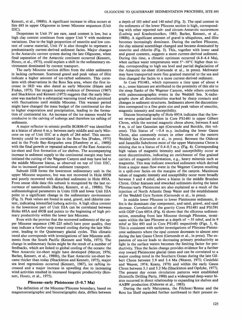
Subunit IIIB forms the lowermost sedimentary unit in the upper Miocene sequence, but was not recovered in Hole 693B and poorly recovered with disturbed sediments in Hole 693A. From smear slide data this subunit is recognized by the last occurrence of nannofossils (Barker, Kennett, et al., 1988b). The sedimentological parameters in Units IIIB and lower Unit HIA point to a significant change in the sedimentary environment (Fig. 3). Peak values are found in sand, gravel, and chlorite content, indicating intensified iceberg activity. A high silica content in the lowermost part of Unit IIIA can be correlated between Holes 693A and 693B and points to the beginning of high primary productivity within the lower late Miocene.
Even with the proviso that the recovered sediments of the upper Miocene sequence (190-225 mbsf) have poor quality, they may indicate a further step toward cooling during the late Miocene, leading to the Quaternary glacial cycles. This climatic trend also corresponds with investigations of late Miocene sediments from the South Pacific (Kennett and Vella, 1975). The change in sedimentary facies might be the result of a number of feedbacks, which are linked to global cooling of the oceans: the West Antarctic ice-sheet might have developed (Mercer, 1976; Barker, Kennett, et al., 1988b), the East Antarctic ice-sheet became thicker than today (Shackleton and Kennett, 1975), major sea level regressions occurred (Kennett, 1967), ice rafting increased and a major increase in upwelling due to increasing wind activities resulted in increased biogenic productivity (Kennett, Houtz, et al., 1975).
Pliocene-early Pleistocene (5-0.7 Ma) The definition of the Miocene/Pliocene boundary, based on
magnetostratigraphic and biostratigraphic data, differs between
a depth of 183 mbsf and 140 mbsf (Fig. 3). The opal content in the sediments of the lower Pliocene section is high, corresponding with other reported sub- and circum-Antarctic occurrences (Ludwig and Krasheninnikov, 1983; Barker, Kennett, et al., 1988b). A significant amount of gravel is ubiquitous, and illite becomes increasingly dominant. During the earliest Pliocene, the clay mineral assemblage changed and became dominated by smectite and chlorite (Fig. 3). This, together with lower sand and gravel contents, suggests a more current-derived sediment. During this time, a climatic optimum occurred (4.8-4.4 Ma), when surface water temperatures were 5°-10°C higher than today, corresponding to high sea level and partial deglaciation of the Antarctic ice-sheet (Gersonde et al., in press). Meltwater may have transported more fine grained material to the sea and thus changed the facies to a more current-derived sediment.
In Core PS1481, which represents a time span of about 4 m.y, some hiatuses are attributed to the proximity of this site to the steep flanks of the Wegener Canyon, while others correlate with paleoceanographic events in the Weddell Sea. X-radio-graphs show all discontinuities marked by sharp contacts and changes in sediment structures. Sediments above the discontinuities correspond to a fine grain size and peak values of smectite, magnetic intensity and susceptibility.
Diatom biostratigraphy of Hole 693A indicates that the lowest reverse polarized section in Core PS 1481 is upper Gilbert Chron, while the normal magnetic chron above, between 8 and 9 m, is of late Gaussian age (Gersonde and Burckle, this volume). This hiatus of ~0.4 m.y. including the lower Gauss Chron, also commonly occurs in other cores of the eastern Weddell Sea (Gersonde et al., in press). Between the Olduvai and Jaramillo Subchrons most of the upper Matuyama Chron is missing due to a hiatus of 0.4-0.5 m.y. (Fig. 4). Corresponding high values of magnetic intensity and susceptibility occur at most discontinuities, indicating an enrichment of fine grained carriers of magnetic information, e.g., heavy minerals such as magnetite. This may indicate reworked sediments which derived from a major mass flow event in the Wegener Canyon resulting in a spill-over facies on the margins of the canyon. Maximum values of magnetic intensity and susceptibility occur more broadly between 3 and 4 mbsf, above a hiatus in the middle Brunhes Chron. Other hiatuses and reworked sediments during the latest Pliocene/early Pleistocene are also explained as a result of the injection of North Atlantic Deep Water and the establishment of the Weddell Gyre System (Gersonde et al., in press).
In middle lower Pliocene to lower Pleistocene sediments, illite is the dominant clay component, and sand, gravel, and opal decrease. Correlation of the gravity Cores PS1481 and PS1591 with ODP Core 693A (Fig. 6) shows that the siliceous sedimentation, extending from late Miocene through Pliocene, terminates within the late Pliocene at a depth of ~ 35 mbsf, and in 9 mbsf at Site 693 and in Core PS 1481 respectively (Figs. 3, 4). This is consistent with earlier investigations of Pliocene-Pleistocene sediments where the opal content decreases to almost zero during the late Gauss Chron (Gersonde et al., in press). The expansion of sea-ice leads to decreasing primary productivity as light in the surface waters becomes the limiting factor for productivity. Thus the facies change provides evidence for a further step toward Pleistocene glacial times and can be correlated to a major cooling trend in the Southern Ocean during the late Gilbert Chron between 3.9 and 3.4 Ma (Weaver, 1973; Ciesielski and Weaver, 1974; Keany, 1978) and within the early Gauss Chron between 3.1 and 3.2 Ma (Shackleton and Opdyke, 1977). The present day ocean circulation patterns were established (Scientific Drilling Party, 1988) and a widespread deep-water hiatus occurred in direct relationship to expanding ice shelves and AABW production (Osborne et al., 1983).
During the early Matuyama, the Filchner/Ronne and the Ross Ice Shelf expanded further northward to their present ex-
125

H. GROBE, D. K. FUTTERER, V. SPIEB
•g, % planktonic % -% & Foraminifers Radiolaria ^ § 0 5 10 0 5
% Gravel
3 0
% Sand/Sill/Clay
50 0
% Smectite/lllite/Chlorite
50 o -i
50 -
100 -
< CO o CD
o X £ ^ co -O E
CU Q
150 -
200 -
250 -
300 -"
Figure 3. Distribution of sedimentological parameters in Hole 693A.
tent (Anderson, 1972; Fillon, 1975). Environmental conditions similar to the late Pleistocene were established —2.4 Ma ago, marked by a drastic change in diatom species composition and the first occurrence of sea-ice diatoms (Gersonde et al., in press). This last cooling trend in the Southern Hemisphere (Hays and Opdyke, 1967; Shackleton and Kennett, 1975) is concomitant with the onset of Northern Hemisphere glaciation (Shackleton and Opdyke, 1977).
Late Pleistocene (0.7 Ma-recent) Detailed investigations of late Pleistocene sediments on the
Weddell Sea continental margin were carried out along a profile off Kapp Norvegia (Grobe, 1986a, b). In that study species composition and fluctuations of biogenic silica and carbonate
content document a sedimentary environment dominated by distinct climatic cyclicity during the late Pleistocene. The distribution of biogenic components in the glaciomarine sediments of Cores PS 1481 and PS 1591 also show typical zones with a relatively high carbonate content, alternating with zones lacking calcareous particles (Figs. 4, 5, and 6). These variations are interpreted as climate controlled (Grobe et al., in press). The carbonate content, which may reach up to 30% in the investigated area, originates from the sinistrally coiled planktonic foraminifer N. pachyderma and a few benthic foraminifers. Very few coccoliths occur in zones with highest carbonate contents.
Compared with the Neogene sediments, the abundance of siliceous microfossils is poor and occurrences are limited to narrow distinct zones, less than 50 cm thick. In the sand fraction,
126
O L I G O C E N E TO QUATERNARY SEDIMENTATION P R O C E S S E S , SITE 693
Carbonate (%) Radiolaria (%) 8 1 8 0 ( ° / o o ) 5 1 3 C (°/oo) IRD (gravel/cm) CD
< 0 10 0 10 5 4 - 0 . 4 0.0 0.4 5 10 0
Sand/Silt/Clay (%) Smectite/Illite/Chlorite (%) Intensity (mA/m)
50 100 50 100 400 800
oo
CO H
CL CD
o 5 O
2 6
f 7 CD Q
10
11
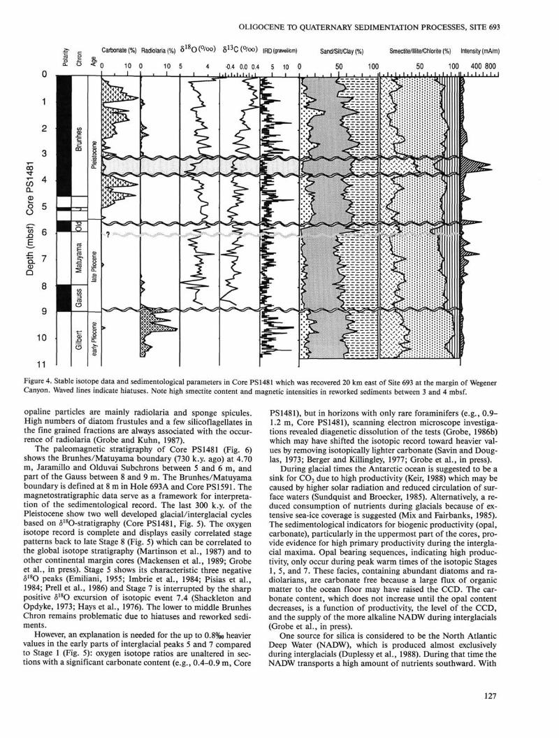
Figure 4. Stable isotope data and sedimentological parameters in Core PS 1481 which was recovered 20 km east of Site 693 at the margin of Wegener Canyon. Waved lines indicate hiatuses. Note high smectite content and magnetic intensities in reworked sediments between 3 and 4 mbsf.
opaline particles are mainly radiolaria and sponge spicules. High numbers of diatom frustules and a few silicoflagellates in the fine grained fractions are always associated with the occurrence of radiolaria (Grobe and Kuhn, 1987).
The paleomagnetic stratigraphy of Core PS 1481 (Fig. 6) shows the Brunhes/Matuyama boundary (730 k.y. ago) at 4.70 m, Jaramillo and Olduvai Subchrons between 5 and 6 m, and part of the Gauss between 8 and 9 m. The Brunhes/Matuyama boundary is defined at 8 m in Hole 693A and Core PS1591. The magnetostratigraphic data serve as a framework for interpretation of the sedimentological record. The last 300 k.y. of the Pleistocene show two well developed glacial/interglacial cycles based on 5180-stratigraphy (Core PS1481, Fig. 5). The oxygen isotope record is complete and displays easily correlated stage patterns back to late Stage 8 (Fig. 5) which can be correlated to the global isotope stratigraphy (Martinson et al., 1987) and to other continental margin cores (Mackensen et al., 1989; Grobe et al., in press). Stage 5 shows its characteristic three negative 5lsO peaks (Emiliani, 1955; Imbrie et al., 1984; Pisias et al., 1984; Prell et al., 1986) and Stage 7 is interrupted by the sharp positive 5180 excursion of isotopic event 7.4 (Shackleton and Opdyke, 1973; Hays et al., 1976). The lower to middle Brunhes Chron remains problematic due to hiatuses and reworked sediments.
However, an explanation is needed for the up to 0.8%o heavier values in the early parts of interglacial peaks 5 and 7 compared to Stage 1 (Fig. 5): oxygen isotope ratios are unaltered in sections with a significant carbonate content (e.g., 0.4-0.9 m, Core
PS1481), but in horizons with only rare foraminifers (e.g., 0.9-1.2 m, Core PS 1481), scanning electron microscope investigations revealed diagenetic dissolution of the tests (Grobe, 1986b) which may have shifted the isotopic record toward heavier values by removing isotopically lighter carbonate (Savin and Douglas, 1973; Berger and Killingley, 1977; Grobe et al., in press).
During glacial times the Antarctic ocean is suggested to be a sink for C0 2 due to high productivity (Keir, 1988) which may be caused by higher solar radiation and reduced circulation of surface waters (Sundquist and Broecker, 1985). Alternatively, a reduced consumption of nutrients during glacials because of extensive sea-ice coverage is suggested (Mix and Fairbanks, 1985). The sedimentological indicators for biogenic productivity (opal, carbonate), particularly in the uppermost part of the cores, provide evidence for high primary productivity during the interglacial maxima. Opal bearing sequences, indicating high productivity, only occur during peak warm times of the isotopic Stages 1,5, and 7. These facies, containing abundant diatoms and radiolarians, are carbonate free because a large flux of organic matter to the ocean floor may have raised the CCD. The carbonate content, which does not increase until the opal content decreases, is a function of productivity, the level of the CCD, and the supply of the more alkaline NADW during interglacials (Grobe et al., in press).
One source for silica is considered to be the North Atlantic Deep Water (NADW), which is produced almost exclusively during interglacials (Duplessy et al., 1988). During that time the NADW transports a high amount of nutrients southward. With
127
H. GROBE, D. K. FUTTERER, V. SPIEB
Carbonate (%) Radiolaria (%) 5 l b O (°/oo) Silt/Clay Smectite (%)
Interglacial (sjagel_)_
Glacial (stages 2,3,4)
Interglacial (stage 5)
Glacial (stage 6)
Interglacial 7)
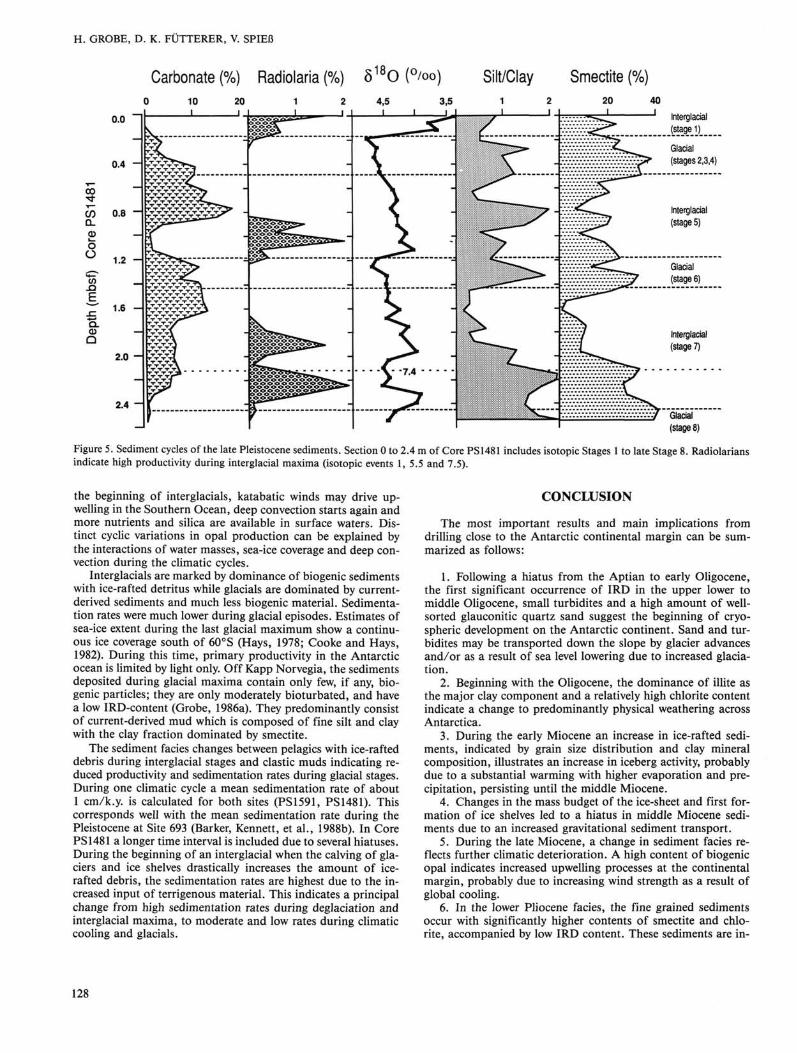
Figure 5. Sediment cycles of the late Pleistocene sediments. Section 0 to 2.4 m of Core PS1481 includes isotopic Stages 1 to late Stage 8. Radiolarians indicate high productivity during interglacial maxima (isotopic events 1, 5.5 and 7.5).
the beginning of interglacials, katabatic winds may drive upwelling in the Southern Ocean, deep convection starts again and more nutrients and silica are available in surface waters. Distinct cyclic variations in opal production can be explained by the interactions of water masses, sea-ice coverage and deep convection during the climatic cycles.
Interglacials are marked by dominance of biogenic sediments with ice-rafted detritus while glacials are dominated by current-derived sediments and much less biogenic material. Sedimentation rates were much lower during glacial episodes. Estimates of sea-ice extent during the last glacial maximum show a continuous ice coverage south of 60°S (Hays, 1978; Cooke and Hays, 1982). During this time, primary productivity in the Antarctic ocean is limited by light only. Off Kapp Norvegia, the sediments deposited during glacial maxima contain only few, if any, biogenic particles; they are only moderately bioturbated, and have a low IRD-content (Grobe, 1986a). They predominantly consist of current-derived mud which is composed of fine silt and clay with the clay fraction dominated by smectite.
The sediment facies changes between pelagics with ice-rafted debris during interglacial stages and clastic muds indicating reduced productivity and sedimentation rates during glacial stages. During one climatic cycle a mean sedimentation rate of about 1 cm/k.y. is calculated for both sites (PS1591, PS1481). This corresponds well with the mean sedimentation rate during the Pleistocene at Site 693 (Barker, Kennett, et al., 1988b). In Core PS 1481 a longer time interval is included due to several hiatuses. During the beginning of an interglacial when the calving of glaciers and ice shelves drastically increases the amount of ice-rafted debris, the sedimentation rates are highest due to the increased input of terrigenous material. This indicates a principal change from high sedimentation rates during deglaciation and interglacial maxima, to moderate and low rates during climatic cooling and glacials.
CONCLUSION
The most important results and main implications from drilling close to the Antarctic continental margin can be summarized as follows:
1. Following a hiatus from the Aptian to early Oligocene, the first significant occurrence of IRD in the upper lower to middle Oligocene, small turbidites and a high amount of well-sorted glauconitic quartz sand suggest the beginning of cryo-spheric development on the Antarctic continent. Sand and turbidites may be transported down the slope by glacier advances and/or as a result of sea level lowering due to increased glaciation.
2. Beginning with the Oligocene, the dominance of illite as the major clay component and a relatively high chlorite content indicate a change to predominantly physical weathering across Antarctica.
3. During the early Miocene an increase in ice-rafted sediments, indicated by grain size distribution and clay mineral composition, illustrates an increase in iceberg activity, probably due to a substantial warming with higher evaporation and precipitation, persisting until the middle Miocene.
4. Changes in the mass budget of the ice-sheet and first formation of ice shelves led to a hiatus in middle Miocene sediments due to an increased gravitational sediment transport.
5. During the late Miocene, a change in sediment facies reflects further climatic deterioration. A high content of biogenic opal indicates increased upwelling processes at the continental margin, probably due to increasing wind strength as a result of global cooling.
6. In the lower Pliocene facies, the fine grained sediments occur with significantly higher contents of smectite and chlorite, accompanied by low IRD content. These sediments are in-
128

OLIGOCENE TO QUATERNARY SEDIMENTATION PROCESSES, SITE 693
* CorePS1591 I £ Carbonate Opal
* Hole693A
i £ Carbonate Opal
* Core PS1481 1 £ Carbonate Opal
Figure 6. Correlation of upper Pliocene-Pleistocene sediments of Hole 693A with gravity cores taken at the same location as Site 693 (PS1591) and close to the Wegener Canyon (PS1481).
terpreted as current-derived and indicate an increased sediment supply from the continent caused by partial melting of the ice-sheet during a climatic optimum from 4.8 to 4.4 Ma ago.
7. Several hiatuses in Pliocene-Pleistocene sediments can be explained by major mass flow events due to the proximity of the Wegener Canyon and as a result of the establishment of the Weddell Gyre system.
8. A high content of siliceous microfossils is found in sediments from early Miocene to late Pliocene age indicating high primary productivity. The high productivity terminates around the Gauss/Gilbert boundary due to the development of a continuous sea-ice cover which limits the light in surface waters. In the Weddell Sea environmental conditions similar to the late Pleistocene were established at ~2.4 Ma ago.
9. Planktonic foraminifers (N. pachyderma) occur in sediments younger than ~ 1 Ma. The sedimentary record of the late Pleistocene sediments is undisturbed between isotope Stage 1 and late Stage 8. Oxygen isotope stratigraphy indicates mean sedimentation rates during one climatic cycle of 1 cm/k.y., with higher rates during the beginning of an interglacial and decreasing values toward glacial times.
10. Changes in biogenic silica and calcium carbonate contents document fluctuating Pleistocene sedimentary environments, which in turn reflect the climatic cycles. The last three interglacials start with a period of high productivity, indicated by distinct opal bearing horizons during peak warm times, then followed by high calcium carbonate fluxes which decrease during the transition from interglacial to glacial times. Thus worldwide climatic amelioration during a deglaciation is documented
in the eastern Weddell Sea by a significant increase in primary production which continues throughout an interglacial. During glacial stages, biogenic components, grain size, and clay composition provide evidence that biological activity is severely reduced due to sea-ice coverage.
ACKNOWLEDGMENTS This research was kindly supported by the Deutsche Forsch-
ungsgemeinschaft (DFG). This is Alfred Wegener Institute for Polar and Marine Research Contribution No. 186.
REFERENCES Anderson, J. B., 1972. The marine geology of the Weddell Sea [Ph.D.
dissert.]. Florida State Univ., Tallahassee, 1-172. Anderson, J. B., Brake, C , Domack, E., Myers, N. C , and Wright, R.,
1983. Development of a polar glacial-marine sedimentation model from Antarctic Quaternary deposits and glaciological information. In Molnia, B. F. (Ed.), Glacial-marine Sedimentation: New York (Plenum Press), 233-264.
Barker, P. F., Kennett, J. P., et al., 1988a. Weddell Sea Palaeoceanography: preliminary results of ODP Leg 113. Palaeogeogr., Palaeoclimatol., Palaeoecol., 67:75-102.
, 1988b. Proc. ODP, Init. Repts., 113: College Station, TX (Ocean Drilling Program).
Barron, J., Larsen, B., et al., 1989. Proc. ODP, Init. Repts., 119: College Station, TX (Ocean Drilling Program).
Berger, W. H., and Killingley, J. S., 1977. Glacial-Holocene transition in deep sea carbonates: selective dissolution and the stable isotope signal. Science, 197:563-566.
Carmack, E. C , 1977. Water mass characteristics of the Southern Ocean south of the Polar Front. In Deacon, G. (Ed.), A voyage of
129
H. GROBE, D. K. FUTTERER, V. SPIEB
Discovery, 17th anniversary Volume, Oxford (Pergamon Press), 15-41.
Carmack, E. C , and Foster, T. D., 1977. Water masses and circulation in the Weddell Sea. In Dunbar, M. J. (Ed.), Polar Oceans: Montreal, 151-165.
Ciesielski, P. R, and Weaver, F. M., 1974. Early Pliocene temperature changes in the Antarctic seas. Geology, 2:511-515.
Cooke, D. W., and Hays, J. D., 1982. Estimates of Antarctic ocean seasonal sea-ice cover during glacial intervals. In Craddock, C. (Ed.), Antarctic geoscience: Madison (Univ. Wisconsin Press), 1017-1025.
Craig, H., 1957. Isotopic standards for carbon and oxygen and correction factors for mass spectrometric analysis. Geochim. Cosmochim. Acta, 12:133-149.
Devereux, I., 1967. Oxygen isotope paleotemperature measurements on New Zealand Tertiary fossils. N. Z. J. Sci., 10:988.
Duplessy, J. C , Shackleton, N. J., Fairbanks, R. G., Labeyrie, L., Oppo, D., and Kallel N., 1988. Deepwater source variations during the last climatic cycle and their impact on the global deepwater circulation. Paleoceanography, 3:343-360.
Elverhdi, A., 1981. Evidence for a late Wisconsin glaciation of the Weddell Sea. Nature, 293:641-642.
Emiliani, C , 1955. Pleistocene temperatures. J. Geol., 63, 538-578. Fillon, R. H., 1975. Late Cenozoic paleoceanography of the Ross Sea,
Antarctica. Geol. Soc. Am. Bull., 86:839-845. Foldvik, A., Gammelsrdd, T., and Trirresen, T., 1985. Circulation and
water masses on the southern Weddell Sea shelf. In Jacobs, S. S. (Ed.), Oceanology of the Antarctic continental shelf : Antarct. Res. Sen, 43:5-20.
Foster, T. D., and Middleton, J. H., 1980. Bottom water formation in the eastern Weddell Sea. Deep-Sea Res., 27A:367-381.
Frakes, L. A., 1975. Paleoclimatic significance of some sedimentary components at Site 274. In Hayes, D. E., Frakes, L. A., et al., Init. Repts. DSDP, 28: Washington (U.S. Govt. Printing Office), 785-787.
Fiitterer, D. K., Grobe, H., and Griinig, S., 1988. Quaternary sediment patterns in the Weddell Sea: relations and environmental conditions. Paleoceanography, 3:551-561.
Gersonde, R., Abelmann, A., and Spie/3, V., in press. Plio-Pleistocene Paleoceanography in the Weddell Sea-siliceous microfossil evidence. In Bleil, U , and Thiede, J. (Eds.), Geological History of Polar Oceans: Arctic versus Antarctic. NATO/ASI Series C: Dordrecht, The Netherlands (Kluwer Academic Pub.).
Grobe, H., 1986a. Sedimentation processes on the Antarctic continental margin at Kapp Norvegia during the late Pleistocene. Geol. Rundschau, 75:97-104.
, 1986b. Spatpleistozane Sedimentationsprozesse am antark-tischen Kontinentalhang vor Kapp Norvegia, Ostliche Weddell See. Ber. Polarforschung, 27:1-121.
, 1987. A simple method for the determination of ice-rafted debris in sediment cores. Polarforschung, 57:123-126.
Grobe, H., and Kuhn, G., 1987. Sedimentation processes at the Antarctic continental margin. In Fiitterer, D. K. (Ed.), The Expedition An-tarktis-IV of RV "Polarstern" 1985/86, Report of Legs ANT-IV/3-4, Ber. Polarforschung, 33:80-84.
Grobe, H., Mackensen, A., Hubberten, H.-W., Spie/3, V., and Fiitterer, D. K., in press. Stable isotope record and late Quaternary sedimentation rates at the Antarctic continental margin. In Bleil, U. and Thiede, J. (Eds.), Geological History of Polar Oceans: Arctic versus Antarctic. NATO/ASI Series C: Dordrecht, The Netherlands (Kluwer Academic Publ.).
Hambrey, M. J., Larsen, B., Ehrmann, W. U , et al., 1989. Forty million years of Antarctic glacial history yielded by Leg 119 of the Ocean Drilling Program. Polar Record, 25:99-106.
Hays, J. D., 1978. A review of the late Quaternary climatic history of Antarctic seas. In Zinderen Bakker, E. M. v. (Ed.), Antarctic glacial history and world paleoenvironments. Proc. Symp. INQUA congress, Birmingham, 57-71.
Hays, J. D., and Opdyke, N. D., 1967. Antarctic radiolaria, magnetic reversals and climatic change. Science, 158:1001-1011.
Hayes, D. E., and Frakes, L. A., et al., 1975. Init. Repts. DSDP, 28: Washington (U.S. Govt. Printing Office), 1-1117.
Hays, J. D., Imbrie, J., and Shackleton, N. J., 1976. Variations in the earth's orbit: pacemaker of the ice ages. Science, 194:1121-1132.
Hut, G , 1987. Stable isotope reference samples for geochemical and hy-drological investigations. Report to the Director General, IAEA, Vienna, 1-42.
Imbrie, J., Hays, J. D., Martinson, D. G., Mclntyre, A., Mix, A. C , Morley, J. J., Pisias, N. G , Prell, W. L., and Shackleton, N. J., 1984. The orbital theory of Pleistocene climate: Support from a revised chronology of the marine 6180 record. In Berger, A., Imbrie, J., Hays, J., Kukla, G., and Saltzmann, (Eds.), Milankovitch and Climate, Dordrecht (D. Reidel), 269-305.
Keany, J., 1978. Paleoclimatic trends in early and middle Pliocene deep-sea sediments of the Antarctic. Mar. Micropaleontol., 3:35-49.
Keir, R. S., 1988. On the late Pleistocene ocean geochemistry and circulation. Paleoceanography, 3:413-445.
Kennett, J. P., 1967. Recognition and correlation of the Kapitean Stage (Upper Miocene, New Zealand). N.Z. J. Geol. Geophys., 10:1051-1063.
, 1978. The Development of Planktonic Biogeography in the Southern Ocean during the Cenozoic. Mar. Micropaleontol., 3:301-345.
Kennett, J. P., Houtz, R. E., et al., 1975. Init. Repts. DSDP, 29: Washington (U.S. Govt. Printing Office).
Kennett, J. P., and Vella, P., 1975. Late Cenozoic planktonic foraminifera and paleoceanography at DSDP Site 284 in the cool subtropical South Pacific. In Kennett, J. P., Houtz, R. E., et al., Init. Repts. DSDP, 29: Washington (U.S. Govt. Printing Office), 769-776.
Kennett, J. P., and Shackleton, N. J., 1976. Oxygen isotopic evidence for the development of the psychrosphere 38 m.y. ago. Nature, 260: 513-515.
Ludwig, W J., Krasheninnikov, V. A., et al., 1983. Init. Repts. DSDP, 71: Washington (U.S. Govt. Printing Office), 1-1178.
Mackensen, A., Grobe, H., Hubberten, H.-W., Spie/3, V , and Fiitterer, D. K., 1989. Stable isotope stratigraphy from the Antarctic continental margin during the last one million years. Mar. Geol., 87:315-321.
Mackensen, A., Grobe, H., Kuhn, G., and Fiitterer, D. K., in press. Benthic foraminiferal assemblages from the eastern Weddell Sea between 68° and 73°S: distribution, ecology and fossilization potential. Mar. Micropaleontol., submitted.
Martinson, D. G., Pisias, N. G., Hays, J. D., Imbrie, J., Moore, T. C , Jr., and Shackleton, N. J., 1987. Age dating and the orbital theory of the Ice Ages: Development of a high-resolution 0 to 300,000-year chronostratigraphy. Quaternary Res., 27:1-29.
Mercer, J. H., 1976. Glacial history of southernmost South America. Quaternary Res., 6:125.
Mix, A. C , and Fairbanks, R. G., 1985. North Atlantic surface-ocean control for Pleistocene deep-ocean circulation. Earth Planet. Sci. Lett., 73:231-243.
Osborne, N. I., Ciesielski, P. F , and Ledbetter, M. T , 1983. Disconfor-mities and paleoceanography in the southeast Indian Ocean during the past 5.4 million years. Geol. Soc. Am. Bull., 94:1345-1358.
Oskierski, W., 1988. Verteilung und Herkunft glazial-mariner Gerolle am Antarktischen Kontinentalrand des ostlichen Weddellmeeres. Ber. Polarforschung, 47:1 -167.
Osterhus, S., 1987. Physical oceanography. In Fiitterer, D. K. (Ed.), The Expedition Antarktis-IV of RV "Polarstern" 1985/86, Report of Legs ANT-IV/3-4, Ber. Polarforschung 33:95-99.
Pisias, N. G , Martinson, D. G., Moore, T. C , Jr., Shackleton, N. J., Prell, W., Hays, J., and Boden, G , 1984. High resolution stratigraphic correlation of benthic oxygen isotopic records spanning the last 300,000 years. Mar. Geol, 56:119-136.
Prell, W. L., Imbrie, J., Martinson, D. G , Morley, J. J., Pisias, N. G., Shackleton, N. J., and Streeter, H. E , 1986. Graphic correlation of oxygen isotope stratigraphy application to the late Quaternary. Paleoceanography, 1:137-162.
Pudsey, C. J., Barker, P. F , and Hamilton, N., 1988. Weddell Sea abyssal sediments: A record of Antarctic Bottom Water flow. Mar. Geol., 81:289-314.
Sarnthein, M., 1971. Oberflachensedimente im Persischen Golf und Golf von Oman. Quantitative Komponentenanalyse der Grobfrak-tion. "Meteor"-Froschungserg., C5:l-112.
Savin, S. M., and Douglas, R. G , 1973. Stable isotope and magnesium geochemistry of recent planktonic foraminifera from the South Pacific. Geol. Soc. Am. Bull., 84:2327-2342.
Shackleton, N. J., and Kennett, J. P., 1975. Late Cenozoic oxygen and carbon isotopic changes at DSDP site 284: Implications of glacial history of the Northern Hemisphere and Antarctica. In Kennett, J. P., Houtz, R. E., et al., Init. Repts. DSDP, 29: Washington (U.S. Govt. Printing Office), 801.
130
OLIGOCENE TO QUATERNARY SEDIMENTATION PROCESSES, SITE 693
Shackleton, N. J., and Opdyke, N. D., 1973. Oxygen isotope and paleomagnetic stratigraphy of equatorial Pacific core V28-238: Oxygen isotope temperature and ice volumes on a 10,000 year and 100,000 year time scale. Quaternary Res., 3:39-55.
, 1977. Oxygen isotope and paleomagnetic evidence for early Northern Hemisphere glaciation. Nature, 270:216-219.
Singer, A., 1984. The paleoclimatic interpretation of clay minerals in sediments-a review. Earth Sci. Rev., 21:251-293.
Sundquist, E. T , and Broecker, W. S. (Eds.), 1985. The carbon cycle and atmospheric C0 2 : natural variations Archean to present. Geophys. Monogr. Sen, 32:1-627.
Weaver, F. M., 1973. Pliocene paleoclimatic and paleoglacial history of East Antarctica recorded in deep-sea piston cores [Ph.D. dissert.]. Florida State Univ., Tallahassee.
Weiss, R. F , Ostlund, H. G. and Craig, H., 1979. Geochemical studies of the Weddell Sea. Deep-Sea Res., 26:1093-112.
Date of initial receipt: 24 March 1989 Date of acceptance: 15 September 1989 Ms 113B-193
131