5-the appraisal of the nyakasura cave and waterfall geosite … · the appraisal of the nyakasura...
TRANSCRIPT

Journal of Environmental Science and Engineering B 6 (2017) 471-483 doi:10.17265/2162-5263/2017.09.005
The Appraisal of the Nyakasura Cave and Waterfall
Geosite‘Amabeere ga Nyina Mwiru’, ToroFort Portal
Scenic Area, Uganda
Molly Kibalama Bakka Male, Richard Kiggwe, Martin Ekiryagaana and Unity Birungi
Mapping Division, Geological Surveys Department, Directorate of Geological Survey and Mines (Ministry of Energy and Mineral
Development, MEMD), Entebbe, Uganda
Abstract: The Nyakasura caves and waterfall geosite of stalagmites and stalactites (191,271 m E, 74,776 m N) locally referred to as
‘Amabere ga Nyina Mwiru’ is part of the NyakasuraFort Portal volcanic field and scenic area. The geosite is one of the country’s
most exciting and educative features. This geosite has been long known and several legends about it were written and taught in schools. The site is taken care of by a family of the Rubomboras in whose home is situated and also referred to as the Wonder of Uganda and named Camp Beseri. The other beautiful sites include the landscape, panorama, the calderas, lava domes, water bearing and dry craters, fauna and flora and others viewed from the Kyeganywa hill (192391, 75681; 1,594 m, 00o41’2.0682” N, 30o14’11.3244” E) in Kabarole district. The nation’s capacity to strengthen geopark development lies in funding the development activities and inviting or attracting geopark expatriates as well as investors. The geopark development is fundamental for harnessing geotourism which is one of the opportunities Uganda has for achieving faster socio-economic transformation as per Uganda’s Vision 2040. Key words: Geosite, geopark, sustainable development, geotourism, geoconservation and geoeducation.
1. Introduction
Uganda is one of the five East African Community
countries. The country occupies an area of 241,000 km2
and lies in the heart of the African plateau within the
African plate, a continental crust containing Archean
Cratons and crossed by the equator. She has a
tropical-equatoria climate in addition to a variety of
landscapes and other physical features (Figs. 1a and
1b), unique flora and fauna with a breath-taking beauty
which gives her another name ‘The Pearl of Africa’.
The income per capita is 1,300$ per annum. Uganda is
endowed with impressive geological sites that are
potential pro-development occurrences.
As part of the general effort to document geosites in
Africa, the OAGSs (Organization of African Geological
Corresponding author: Molly Kibalama Bakkka Male, B.Sc.,
research fields: geology, chemistry, geosites-geopark initiative and geopark development.
Surveys) invited the GSU (Geological Survey of
Uganda) to submit information on the subject. In due
course of assignment, there was increased awareness
of the importance of geosites and the related concept
of ‘Geopark’. The Survey is currently working towards
having the Nyakasura cave and waterfalls geosite
pioneer in the nation’s geosite recognition. The geosite
comprising a cave, stalamites and stalactites is the
only one of its kind in Uganda with aesthetic, scientific,
cultural and other unique values. It is a natural
occurrence in the volcanic hills of Toro, famous for its
legendary and cultural importance. The Directorate of
Geological Survey and Mines, therefore, supported the
appraisal and pledge to facilitate the activities towards
the enhancement of its geographical and geological
character. The eventual recognition of this geosite will
create public awareness of its pro development
potential through the promotion of geotourism. The
concepts ‘geosites’, ‘geopark’, ‘geotourism’ and
D DAVID PUBLISHING

The Appraisal of the Nyakasura Cave and Waterfall Geosite‘Amabeere ga Nyina Mwiru’, ToroFort Portal Scenic Area, Uganda
472
Fig. 1a Caldera, lava dam lake, landscape and flora.
Fig. 1b Signage to echo camp.
‘geoheritage’ are new, interesting and important in
geoscience and have fast developing frameworks
[1-12]. Brilha, J. [2] defines a geosite as an occurrence
of one or more elements of geodiversity outcropping
from the action of natural processes or due to human
intervention, well geographically delimited and with
exceptional scientific value. Other values may also be
present. Ehsan, S., et al. [8] denotes geotourim as
utilization of geological heritage resources for
education-based tourism-geoeducation; the site

The Appraisal of the Nyakasura Cave and Waterfall Geosite‘Amabeere ga Nyina Mwiru’, ToroFort Portal Scenic Area, Uganda
473
provides a formal and informal education facility,
geoconservation; protecting geosites and current
geoheritage is passed on to future generations as a
potential Palaeo environmental record preserved in
landforms and sediments. The Nyakasura caves and
waterfalls occurrence are a potential geotourism
product that already protects geoheritage, sustains
communities, communicates and promotes geological
heritage and works with a wide range of different
people. The official recognition of this geosite will
promote awareness and further the understanding of
the public authorities, private interests, local
community and the other stake holders of the geological
resource potential and its contribution to sustainable
development. The Nyakasura caves geosite also known
as Amabeere (breasts) caves geosite is located 8 km
west of Fort Portal town off Bundibugyo road in a
lovely hilly area and dotted with crater lakes. It is a
limestone lain area and cave having stalagmites and
stalactites. The geosite is a key feature of the proposed
Western Region Geopark. The locally available
information [9-12] on Uganda geosites and Uganda
geoparks development which started in 2009 is found
in the unpublished reports with documentation on
potential geosites some of which belong to the
proposed Western Region Geopark of Uganda.
A geopark approach is an appropriate sustainable
development strategy that can be integrated with the
other development strategies. It will be a remedy if
adopted to many of the African problems of poverty,
hunger, economy and development to match the
Uganda Vision 2040 “A transformed Uganda society
from a peasant to a modern and prosperous country
within 30 years” [13].
2. Nyakasura Geosite Position, Location and Access
The Nyakasura geosite in Kabarole district (Fig. 1c)
is 256 km from Kampala following the Kampala-Fort
Portal tarmac road. There are two tarmac roads that
connect from Fort Portal town to Bundibugyo (56 km)
and Kasese (68 km). The geosite is located 8 km west
of Fort Portal and off Bundibugyo road, branching at
the Nyakasura secondary school. The site has a cave
and the waterfall is seen flowing through the roof of
the cave.
Fig. 1c Geosite positioning (Africa-East Africa-Uganda-Western Uganda).
The Appraisal of the Nyakasura Cave and Waterfall Geosite‘Amabeere ga Nyina Mwiru’, ToroFort Portal Scenic Area, Uganda
474
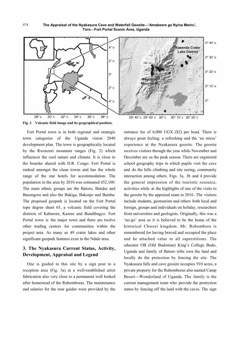
Fig. 2 Volcanic field image and its geographical position.
Fort Portal town is in both regional and strategic
town categories of the Uganda vision 2040
development plan. The town is geographicaliy located
by the Rwenzori mountain ranges (Fig. 2) which
influences the cool nature and climate. It is close to
the boarder shared with D.R. Congo. Fort Portal is
ranked amongst the clean towns and has the whole
range of the star hotels for accommodation. The
population in the area by 2010 was estimated 452,100.
The main ethnic groups are the Batoro, Batuku and
Basongora and also the Bakiga, Bakonjo and Bamba.
The proposed geopark is located on the Fort Portal
topo degree sheet 65, a volcanic field covering the
districts of Kabarore, Kasese and Bundibugyo. Fort
Portal town is the major town and there are twelve
other trading centers for communities within the
project area. As many as 49 crater lakes and other
significant geopark features exist in the Ndale area.
3. The Nyakasura Current Status, Activity, Development, Appraisal and Legend
One is guided to this site by a sign post to a
reception area (Fig. 3a) at a well-established artist
fabrication also very close to a permanent well looked
after homestead of the Rubomboras. The maintenance
and salaries for the tour guides were provided by the
entrance fee of 6,000 UGX ($2) per head. There is
always great feeling; a refreshing and the ‘no stress’
experience at the Nyakasura geosite. The geosite
receives visitors through the year while November and
December are as the peak season. There are organized
school geography trips in which pupils visit the cave
and do the hills climbing and site seeing, community
interaction among others. Figs. 3a, 3b and 4 provide
the general impression of the touristic resource,
activities while at the highlights of one of the visits to
the geosite by the appraisal team in 2016. The visitors
include students, geotourists and others both local and
foreign, groups and individuals on holiday, researchers
from universities and geologists. Originally, this was a
‘no-go’ area as it is believed to be the home of the
historical Chwezi kingdom. Mr. Rubombora is
remembered for having braved and occupied the place
and he attached value to all superstitions. The
educator OB (Old Budonian) King’s College Budo,
Uganda and family of Batoro tribe own the land and
locally do the protection by fencing the site. The
Nyakasura falls and cave geosite occupies 910 acres, a
private property for the Rubomboras also named Camp
BeseriWonderland of Uganda. The family is the
current management team who provide the protection
status by fencing off the land with the caves. The sign

The Appraisal of the Nyakasura Cave and Waterfall Geosite‘Amabeere ga Nyina Mwiru’, ToroFort Portal Scenic Area, Uganda
475
Fig. 3a Campsite reception.
Fig. 3b The Nyakasura geological touristic resources.
posts direct the visitors to the camp site and they have
a reception place and tour guides. New tracks for
climbing the hills, accessing the crater lakes and
viewing the calderas were constructed.
The Nyakasura cave and falls geosite is included in
the school geography and history syllabi taught as a
physical feature of western Uganda and as a legend
respectively. The legend is very interesting and has
been taught in primary schools for 120 years. The cave
‘Amabeere ga nyina Mwiru’ (breasts of Mwiru’s mother)
is named after Nyinamwiru who was the daughter of
Bukuku the gate keeper during the Batembuzi
dynastypredecessors of the current Babito Kings of
Toro and Bunyoro kingdom. She was a beautiful girl
who refused to marry the man her father chose for her.
As a result, she was punished by cutting off her
breasts, which then grew into rock dripping with milk.
He eventually hid her away in the caves. Whilst there,
Nyinamwiru was impregnated by the Batembuzi King
Isaza to give birth to Ndahura, the future founder of
the Bachezi dynasty. Because she had no breasts, she
fed the infant with the cloudy limestone ‘milk’ that
Sign post Tour guide Path to the caves
Geologists at camp, 2015 Waterfall Camp Beseri

The Appraisal of the Nyakasura Cave and Waterfall Geosite‘Amabeere ga Nyina Mwiru’, ToroFort Portal Scenic Area, Uganda
476
drips from the breast-like stalactites. Legend has it that
after, Ndahura surrendered the Bachwezi throne to his
son and retired to his birthplace. Foot prints can still
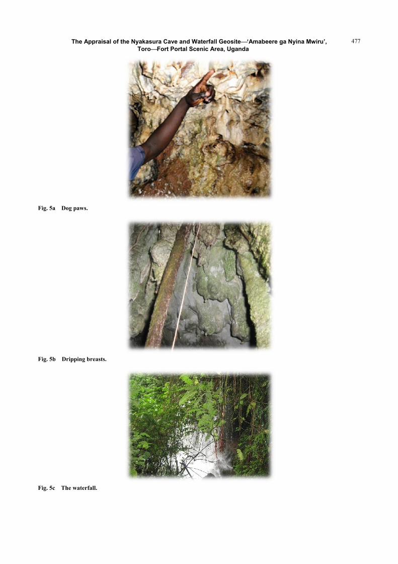
be reportedly be seen in the cave’s vicinity. Several
other legends are told about the cave. One chamber is
said to have been the resting place of the Bachwezi
dogs, and the ceiling shows pits resembling dog paws
(Fig. 5a). The dripping water from the woman breast
shaped stalactites (Fig. 5b) deposited white calcite, so
the water looks whitish. This is why the local
community calls it breast milk.
However, the guides are well educated and tell the
scientific background as well as the legend.
A waterfall called Natural Shower (Fig. 5c) is said
to have been used by the Bachwezi to take showers.
The visitors are also allowed to do so if they wish.
Fig. 4 Appraisal visit team, 2016.
Caldera
The team with Jajja Rubomboras (RIP, 2017)
The Appraisal of the Nyakasura Cave and Waterfall Geosite‘Amabeere ga Nyina Mwiru’, ToroFort Portal Scenic Area, Uganda
477
Fig. 5a Dog paws.
Fig. 5b Dripping breasts.
Fig. 5c The waterfall.

The Appraisal of the Nyakasura Cave and Waterfall Geosite‘Amabeere ga Nyina Mwiru’, ToroFort Portal Scenic Area, Uganda
478
Fig. 6a Inside the cave.
Fig. 6b Visitor boot.
The Nyakasura appraisal exercise objective is to
highlight the existence of the unique heritage and
promotes awareness of its embedded potential as a
development strategy and also to identify the
problems and challenges at the site and to package for
investors and seek for expert help and guidance on
geosite enhancement and development. The inventorying
activity of the geosites is a continuous exercise with
GIS-aided data collection intended to track geotrails
and route that goes through the proposed geopark. The
tour involves a 3-hour walk with tour guides inside the
caves (Fig. 6a) and later the other elements outside the
caves which include climbing to the highest hill top
and trailing the crater lakes, calderas and domes,
beautiful little hills that allows one to appreciate the
stress killing panorama. The caves and falls
management reports a growing visitor record for the
last forty years. However, the cave requires quick
protection intervention from the many threatseffects
of frequent earth tremors, heavy rains, heavy
vegetation-eucalyptus trees on the roof of the cave and
visitor walking on the growing stalagmite (Fig. 6b).
5. The Proposed Geopark Route
The geopark tour may be started with Nyakasura
geosite as ‘gateway’ or entry point. The draft map (Fig. 7)
shows one possibility of a geopark area and the GPS
track record of possible route from NyakasuraFort
Portal taking Kamwenge road through Ndale crater
lakes villages. The corresponding readings of
coordinates for the stops or visited sites in the geopark
are listed in Table 1. The panorama, relaxing ambience,
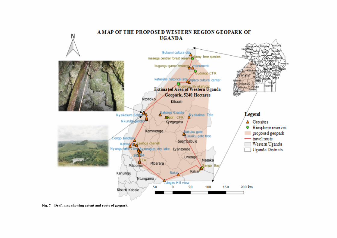
Fig. 7 Draft map showing extent and route of geopark.

Table 1 Coordinates of the visited sites in the geopark (biosphere and geosites).
Site description Description Easting x Northing y Elevation (m) Latitude x Longitude y District
Katoosa central point 238,201 69,944 1,373 00o37’56.1659” N 30o38’52.0854” E Kyenjojo
Mabeere ga Nyina Mwiru Point 1 meeting 191,211 75,052 1,571 00o40’41.5835” N 30o13’33.2026” E Kabarole
lake view point 191,931 75,193 1,591 00o 40’46.1839” N 30o13’56.4678” E Kabarole
Kyeganwa foot hills 192,391 75,681 1,594 00o41’2.0682” N 30o14’11.3244” E Kabarole
Nyakasura school 190,722 74,356 1,565 00o40’18.9323” N 30o13’17.4127” E Kabarole
Lake Nkuruma junction 199,581 57,468 1,505 00o31’9.6611” N 30o18’3.9791” E Kabarole
Lake Nkuruma camp site 199,603 57,668 1,493 00o31’16.1682” N 30o18’4.6874” E Kabarole
L Katwe Tc 821,017 9,984,098 913 00o8’37.2731” S 29o53’1.2528” E Kasese
Lake Katwe st 819,856 9,985,848 887 00o7’40.3519” S 29o52’23.7327” E Kasese
Kalinzu forest reserve stop 1 179,800 9,940,572 1,616 00o32’13.1339” S 30o7’24.7257” E Rubirizi
meeting pt 179,029 9,958,488 1,504 00o22’30.3362” S 30o7’0.0448” E Rubirizi
Bunyaruguru dry wells 179,721 9,970,864 1,316 00o15’47.7648” S 30o7’22.5166” E Rubirizi
Kashoha forest reserve 182,155 9,968,232 1,281 00o17’13.401” S 30o8’41.1433” E Bushenyi
Nsongezi 249,746 9,890,266 1,232 00o59’31.2986” S 30o45’4.596” E Ishingiro
Sango bay 340,567 9,931,814 1,204 00o37’0.1407” S 31o34’2.2215” E Rakai
Bigo bya Mugenyi shrine 306,255 16,963 1,227 00o9’12.2338” N 31o15’32.854” E Ssembabule
Bukuuku gate tree 304,681 17,343 1,104 00o9’24.6005” N 31o14’41.9542” E Ssembabule
Nyakaima tree 319,456 63,433 1,572 00o34’25.1993” N 31o22’39.4828” E Mubende
Budongo CFR 337,380 187,832 3,587 01o41’55.7286” N 31o32’17.1464” E Masindi
Bbugungu game reserve 319,763 197,105 807 01o46’57.1714” N 31o22’46.8972” E Buliiasa
Bukumii Geosite extrctn of Marram 323,988 233,004 613 02o6’26.0708” N 31o25’2.5085” E Buliiasa
Masege central forest reserve 328,834 223,013 638 02o1’0.9411” N 31o27’39.647” E Buliiasa
Marram etraction site 2 320,422 198,156 724 01o47’31.4077” N 31o23’8.1892” E Buliiasa
Ebony tree species 329,475 221,957 625 02o0’26.5794” N 31o28’0.4222” E Buliiasa

The Appraisal of the Nyakasura Cave and Waterfall Geosite‘Amabeere ga Nyina Mwiru’, ToroFort Portal Scenic Area, Uganda
481
Fig. 8 The geology of the Nyakasura geosite area.
Fig. 9 Lapilli tuffs.
the banana plantations, the people and culture among
others are the attractions on route. The other
attractions included biotic, archeological and cultural
sites biosphere reserves, the Queen Elizabeth National
Park, salt production project at Katwe, lime and
cement production at Hima, the west arm of the East
African rift valley and others. The available hotels,
motels and lodging range in stars to five star hotels.

The Appraisal of the Nyakasura Cave and Waterfall Geosite‘Amabeere ga Nyina Mwiru’, ToroFort Portal Scenic Area, Uganda
482
6. The Area Geology
The area geology (Fig. 8) is dominated by volcanic
Lapilli tuffs (Fig. 9) which are pale grey in colour.
They occupy the hills and form the rich black soils
that favour agriculture. The tuff layers range from a
few centimetres close to a metre. The tuffs surround
the beautiful crater lakes. The crater lakes region is
underlain with the Lapilli tuffs. They are raw
materials for making building blocks for many houses
including those of the RubomborasCaves Campsite.
7. Way Forward
The Geological Surveys Department, Ministry of
Energy should continue with community awareness
programs on what geosites and geoparks are and their
importance. The Ministry continues to receive
proposals and facilitation of the geosite development
activities and is financially supported. The activities
include the inventorying, GPS aided tracking and
making geopark map. The Ministry’s main function is
to create an enabling environment in order to attract
investment in the development of the resource. There
is need to search for and develop partnerships with
investors and geosite-geopark experts. They will
together supplement the technical gaps, guide on the
work plan and budget for the development of the
geopark and mobilize the participation of public
authorities, private interests and local communities.
8. Conclusion and Recommendations
There is hope for the area developing as a result of
the existence of Nyakasura geosite. The Geological
Survey and Mines Department has so far contributed
to the collection of geosites and a list of the geosites
that exists in the country has been generated. The
potential of the geosite is evident. The community
begins to appreciate the importance of the geosite and
would benefit from its development. Many visitors
appreciate the stress-killer environment as well as
learning and leisure. Training and exposure of the
geosites team through refresher courses, conferences
and seminars by geosite-geopark investors and experts
in order to equip the members with the knowledge and
skills to speed up the promotion and development of
these sites. The Directorate of Geology will have
contributed towards the economic growth of this
country as per its mandate.
References
[1] Reynard, E., Brilha, J., eds. 2017. Geoheritage Assessment, Protection and Management (1st Edition). Elsevier. Accessed December 28, 2017. https://www.elsevier.com/books/geoheritage/reynard/978-0-12-809531-7?start_rank=1&sortby=sortByDateDesc&cat0=earth-and-planetary-sciences&cat1=geology.
[2] Brilha, J. 2015. “Inventory and Quantitative Assessment
of Geosites and Geodiversity Sites: A Review.” Accessed
January 2, 2018.
https://www.researchgate.net/publication/270876577_Inv
entory_and_Quantitative_Assessment_of_Geosites_and_
Geodiversity_Sites_a_ReviewSeptember.
[3] Carvalho, A., Pereira, P., and Brilha, J. 2012. “Protecting
and Using Geosites: A Project to Establish Geoheritage
Management Procedures.” In Proceedings of the 11th
European Geoparks Conference. Accessed May 7, 2017.
http://www.europeangeoparks.org/wp-content/uploads/20
15/09/11th-EGN-Conference-Arouca-Geopark.pdf.
[4] Zouros, N., and Gumus, E. “Geosite Identification in Aspiring Kula Volcanic Geopark, Turkey.” In Proceedings of the 11th European Geoparks Conference, 143-4. Accessed May 15, 2017. http://www.europeangeoparks.org/wp-content/uploads/2015/09/11th-EGN-Conference-Arouca-Geopark.pdf.
[5] Zouros, N. 2004. “The European Geoparks Network. Geological Heritage Protection and Local Development.” Episodes 27 (3): 165-71.
[6] Eder, F. W., and Patzak, M. 2004. “Geoparks-Geological
Attractions: A Tool for Public Education, Recreation and
Sustainable Economic Development.” Accessed May 15, 2017.
https://www.researchgate.net/publication/279563920_Ge
oparks-geological_attractions_A_tool_for_public_education_recreation_and_sustainable_economic_development.
[7] Hose, H. A. 2012. Editorial: Geotourism and
Geoconservation. Accessed May 22, 2017.
http://www.academia.edu/29530054/Editorial_Geotourism_and_Geoconservation.
[8] Ehsan, S., Leman, M. S., and Ara Begum, R. 2012.
“Geotourism: A Tool for Sustainable Development of Geoheritage Resources.” Accessed May 22, 2017.
https://www.scientific.net/AMR.622-623.1711.

The Appraisal of the Nyakasura Cave and Waterfall Geosite‘Amabeere ga Nyina Mwiru’, ToroFort Portal Scenic Area, Uganda
483
[9] Molly Kibalama Male, B. 2009. “Uganda Geosites.” Poster presentation at Africa GIS Conference 2009, Department of Geological Survey and Mines, Entebbe, Uganda.
[10] Schumann, A., and Muwanga, A., 2003. “Geotope in Uganda.”Aufschluss 54: 89-94.
[11] Schumann, A. 2011. Uganda Geological Mapping: Geosites North of 1o North. Unpublished report for GTK
Consortium. [12] Staudt, M. 2010 Geosites in Uganda for the Uganda
Mapping Project: A Review of Available Information from Literature and Gained from Interviews and Field Visits. Unpublished report for GTK, 9.
[13] National Planning Authority. 2013. Uganda Vision 2040. Kampala: National Planning Authority Planning House.