39. seismic stratigraphy of the neogene sequence … · 39. seismic stratigraphy of the neogene...
TRANSCRIPT
39. SEISMIC STRATIGRAPHY OF THE NEOGENE SEQUENCE AT SITE 5871
Alain Mignot and Alain Mauffret, Département de Géologie Dynamique, Université Pierre et Marie Curie2
INTRODUCTION
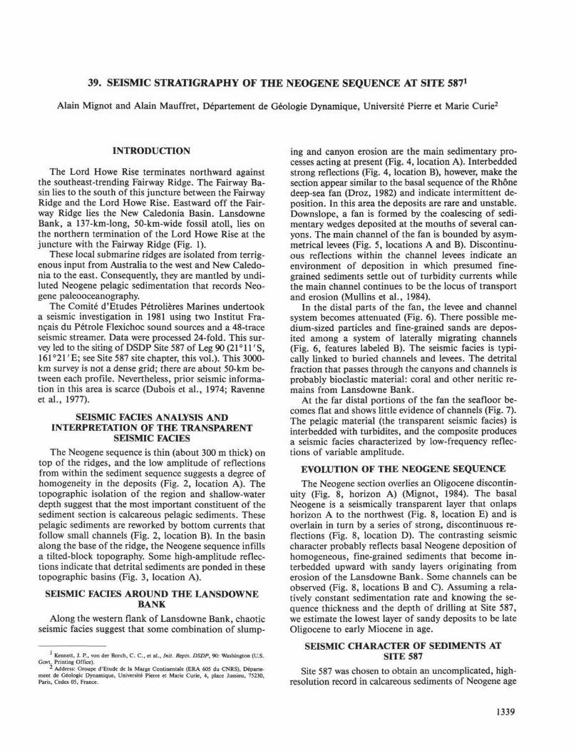
The Lord Howe Rise terminates northward againstthe southeast-trending Fairway Ridge. The Fairway Ba-sin lies to the south of this juncture between the FairwayRidge and the Lord Howe Rise. Eastward off the Fair-way Ridge lies the New Caledonia Basin. LansdowneBank, a 137-km-long, 50-km-wide fossil atoll, lies onthe northern termination of the Lord Howe Rise at thejuncture with the Fairway Ridge (Fig. 1).
These local submarine ridges are isolated from terrig-enous input from Australia to the west and New Caledo-nia to the east. Consequently, they are mantled by undi-luted Neogene pelagic sedimentation that records Neo-gene paleooceanography.
The Comité d'Etudes Pétrolières Marines undertooka seismic investigation in 1981 using two Institut Fra-nçais du Pétrole Flexichoc sound sources and a 48-traceseismic streamer. Data were processed 24-fold. This sur-vey led to the siting of DSDP Site 587 of Leg 90 (21 ° 11' S,161°21'E; see Site 587 site chapter, this vol.). This 3000-km survey is not a dense grid; there are about 50-km be-tween each profile. Nevertheless, prior seismic informa-tion in this area is scarce (Dubois et al., 1974; Ravenneet al., 1977).
SEISMIC FACIES ANALYSIS ANDINTERPRETATION OF THE TRANSPARENT
SEISMIC FACIES
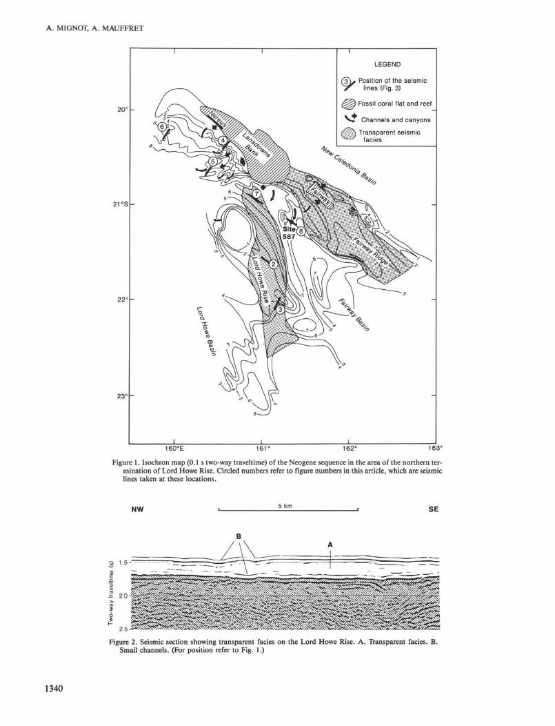
The Neogene sequence is thin (about 300 m thick) ontop of the ridges, and the low amplitude of reflectionsfrom within the sediment sequence suggests a degree ofhomogeneity in the deposits (Fig. 2, location A). Thetopographic isolation of the region and shallow-waterdepth suggest that the most important constituent of thesediment section is calcareous pelagic sediments. Thesepelagic sediments are reworked by bottom currents thatfollow small channels (Fig. 2, location B). In the basinalong the base of the ridge, the Neogene sequence infillsa tilted-block topography. Some high-amplitude reflec-tions indicate that detrital sediments are ponded in thesetopographic basins (Fig. 3, location A).
SEISMIC FACIES AROUND THE LANSDOWNEBANK
Along the western flank of Lansdowne Bank, chaoticseismic facies suggest that some combination of slump-
1 Kennett, J. P., von der Borch, C. C , et al., Init. Repts. DSDP, 90: Washington (U.S.Govt. Printing Office).
2 Address: Groupe d'Etude de la Marge Continentale (ERA 605 du CNRS), Départe-ment de Geologic Dynamique, Université Pierre et Marie Curie, 4, place Jussieu, 75230,Paris, Cedex 05, France.
ing and canyon erosion are the main sedimentary pro-cesses acting at present (Fig. 4, location A). Interbeddedstrong reflections (Fig. 4, location B), however, make thesection appear similar to the basal sequence of the Rhonedeep-sea fan (Droz, 1982) and indicate intermittent de-position. In this area the deposits are rare and unstable.Downslope, a fan is formed by the coalescing of sedi-mentary wedges deposited at the mouths of several can-yons. The main channel of the fan is bounded by asym-metrical levees (Fig. 5, locations A and B). Discontinu-ous reflections within the channel levees indicate anenvironment of deposition in which presumed fine-grained sediments settle out of turbidity currents whilethe main channel continues to be the locus of transportand erosion (Mullins et al., 1984).
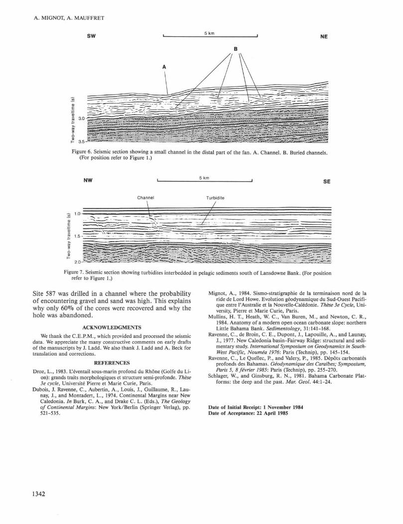
In the distal parts of the fan, the levee and channelsystem becomes attenuated (Fig. 6). There possible me-dium-sized particles and fine-grained sands are depos-ited among a system of laterally migrating channels(Fig. 6, features labeled B). The seismic facies is typi-cally linked to buried channels and levees. The detritalfraction that passes through the canyons and channels isprobably bioclastic material: coral and other neritic re-mains from Lansdowne Bank.
At the far distal portions of the fan the seafloor be-comes flat and shows little evidence of channels (Fig. 7).The pelagic material (the transparent seismic facies) isinterbedded with turbidites, and the composite producesa seismic facies characterized by low-frequency reflec-tions of variable amplitude.
EVOLUTION OF THE NEOGENE SEQUENCE
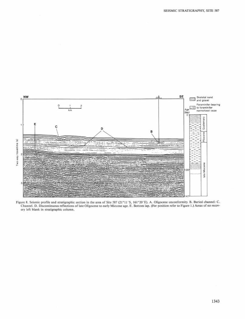
The Neogene section overlies an Oligocene discontin-uity (Fig. 8, horizon A) (Mignot, 1984). The basalNeogene is a seismically transparent layer that onlapshorizon A to the northwest (Fig. 8, location E) and isoverlain in turn by a series of strong, discontinuous re-flections (Fig. 8, location D). The contrasting seismiccharacter probably reflects basal Neogene deposition ofhomogeneous, fine-grained sediments that become in-terbedded upward with sandy layers originating fromerosion of the Lansdowne Bank. Some channels can beobserved (Fig. 8, locations B and C). Assuming a rela-tively constant sedimentation rate and knowing the se-quence thickness and the depth of drilling at Site 587,we estimate the lowest layer of sandy deposits to be lateOligocene to early Miocene in age.
SEISMIC CHARACTER OF SEDIMENTS ATSITE 587
Site 587 was chosen to obtain an uncomplicated, high-resolution record in calcareous sediments of Neogene age
1339
A. MIGNOT, A. MAUFFRET
20'
21 °S
22(
23<
LEGEND
Position of the seismiclines (Fig. 3)
Fossil coral flat and reef
Channels and canyons
Transparent seismicfacies
160°E 161" 162° 163°
Figure 1. Isochron map (0.1 s two-way traveltime) of the Neogene sequence in the area of the northern ter-mination of Lord Howe Rise. Circled numbers refer to figure numbers in this article, which are seismiclines taken at these locations.
NW 5 km SE
Figure 2. Seismic section showing transparent facies on the Lord Howe Rise. A. Transparent facies. B.Small channels. (For position refer to Fig. 1.)
1340

sw 5 km
SEISMIC STRATIGRAPHY, SITE 387
NE
Figure 3. Seismic section showing a transparent layer on the Lord Howe Rise infilling a tilted-block topography. A.Depression infilled with sediments that are coarser than in the surrounding area. (For position refer to Figure 1.)
o.o r
ε 1.0 -
Figure 4. Seismic section showing the western slope of Lansdowne Bank, where slumping and erosion has oc-curred. (For position refer to Figure 1.) A. Slumps and erosion; B. Interbedded strong reflection.
SW 5 km NE
Figure 5. Seismic section showing channels in the fan off Lansdowne Bank. A. Channel. B. Levee. C. Discontinuousreflector indicating high-energy environment. (For position refer to Figure 1.)
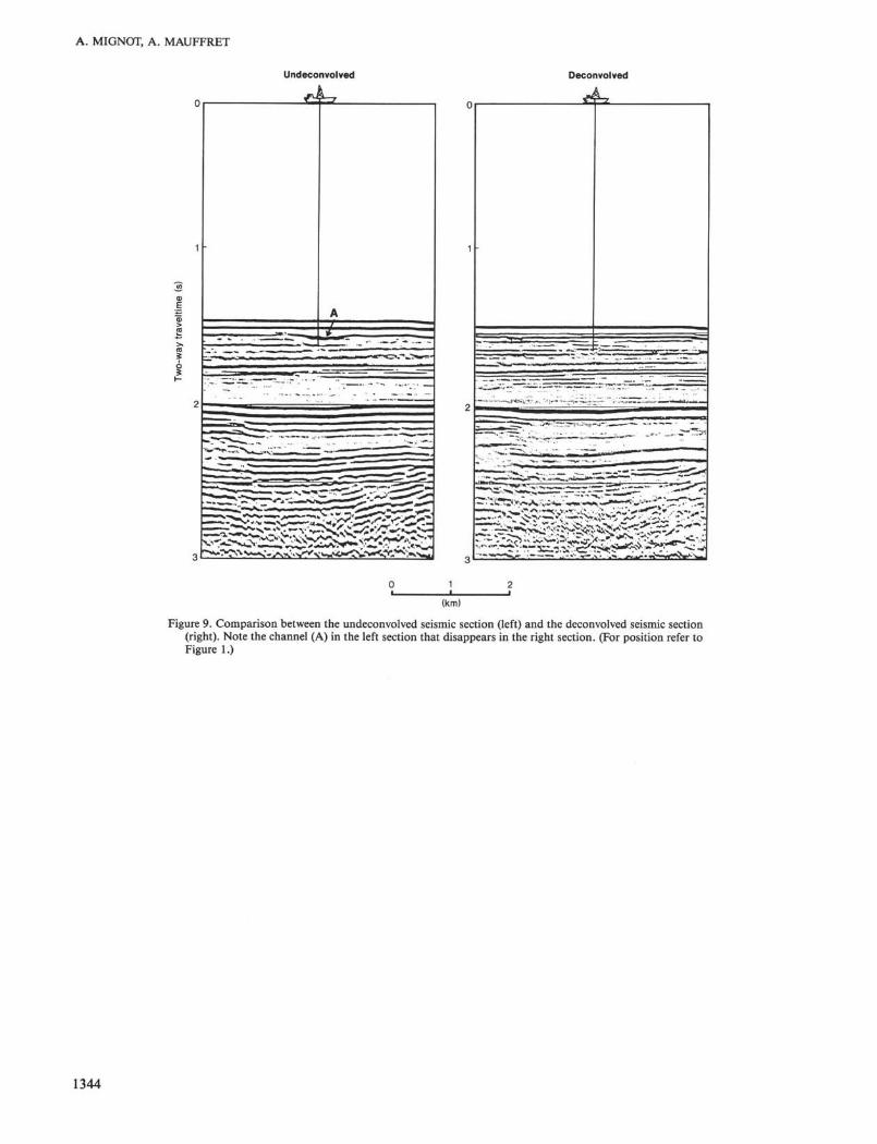
between the warm subtropics and the equatorial zone.Unfortunately, Site 587 was located in a channel wheredetrital sediments from Lansdowne Bank (located up-slope) accumulated. This channel could have been avoid-ed if different displays of the seismic data had been con-sulted. Figure 9 shows the data before and after decon-volution. Deconvolution in this case has obliterated the
obvious channel that appears in the seismic section pri-or to deconvolution.
CONCLUSION
The flank of Lansdowne Bank is a typical bypass car-bonate slope that is located upslope from a carbonatefan (Ravenne et al., 1985); Schlager and Ginsburg, 1981).
1341
A. MIGNOT, A. MAUFFRET
SW 5 kmNE
Figure 6. Seismic section showing a small channel in the distal part of the fan. A. Channel. B. Buried channels.(For position refer to Figure 1.)
NW 5 kmSE
Channel Turbidite
/
I.O:_; _:...._;..._. 7I_.
m -is
Figure 7. Seismic section showing turbidites interbedded in pelagic sediments south of Lansdowne Bank. (For positionrefer to Figure 1.)
Site 587 was drilled in a channel where the probabilityof encountering gravel and sand was high. This explainswhy only 60% of the cores were recovered and why thehole was abandoned.
ACKNOWLEDGMENTS
We thank the C.E.P.M., which provided and processed the seismicdata. We appreciate the many constructive comments on early draftsof the manuscripts by J. Ladd. We also thank J. Ladd and A. Beck fortranslation and corrections.
REFERENCES
Droz, L., 1983. Uéventail sous-marin profond du Rhone (Golfe du Li-on): grands traits morphologiques et structure semi-profonde. These3e cycle, Université Pierre et Marie Curie, Paris.
Dubois, J. Ravenne, C , Aubertin, A., Louis, J., Guillaume, R., Lau-nay, J., and Montadert, L., 1974. Continental Margins near NewCaledonia. In Burk, C. A., and Drake C. L. (Eds.), The Geologyof Continental Margins: New York/Berlin (Springer Verlag), pp.521-535.
Mignot, A., 1984. Sismo-stratigraphie de la terminaison nord de laride de Lord Howe. Evolution géodynamique du Sud-Ouest Pacifi-que entre PAustralie et la Nouvelle-Calédonie. These 3e Cycle, Uni-versity, Pierre et Marie Curie, Paris.
Mullins, H. T., Heath, W. C , Van Buren, M., and Newton, C. R.,1984. Anatomy of a modern open ocean carbonate slope: northernLittle Bahama Bank. Sedimentology, 31:141-168.
Ravenne, C , de Broin, C. E., Dupont, J., Lapouille, A., and Launay,J., 1977. New Caledonia basin-Fairway Ridge: structural and sedi-mentary study. International Symposium on Geodynamics in South-West Pacific, Noumea 1976: Paris (Technip), pp. 145-154.
Ravenne, C , Le Quellec, P., and Valery, P., 1985. Depots carbonatesprofonds des Bahamas. Géodynamique des Caraibes; Symposium,Paris 5, 8 février 1985: Paris (Technip), pp. 255-270.
Schlager, W., and Ginsburg, R. N., 1981. Bahama Carbonate Plat-forms: the deep and the past. Mar. Geol. 44:1-24.
Date of Initial Receipt: 1 November 1984Date of Acceptance: 22 April 1985
1342
SEISMIC STRATIGRAPHY, SITE 587
NW Skeletal sandand gravel
Foraminifer-bearing^ to foraminifer
, 9e. nannofossil ooze(Ma)
o-
_ L - _ Å _
— L l —*- l -
" ' ' ' I ' " ' ••["'J_ -X. J
> ,
CO
c
15σΦcα>oo
<B
c(1)
8
15
Figure 8. Seismic profile and stratigraphic section in the area of Site 587 (21 ° 11 'S, 161°20'E). A. Oligocene unconformity, B. Buried channel: C.Channel. D. Discontinuous reflections of late Oligocene to early Miocene age. E. Bottom lap. (For position refer to Figure 1.) Areas of no recov-ery left blank in stratigraphic column.
1343
A. MIGNOT, A. MAUFFRET
Undeconvolved Deconvolved
(km)
Figure 9. Comparison between the undeconvolved seismic section (left) and the deconvolved seismic section(right). Note the channel (A) in the left section that disappears in the right section. (For position refer toFigure 1.)
1344