28223832 special course geomodeling
DESCRIPTION
geomodelingTRANSCRIPT
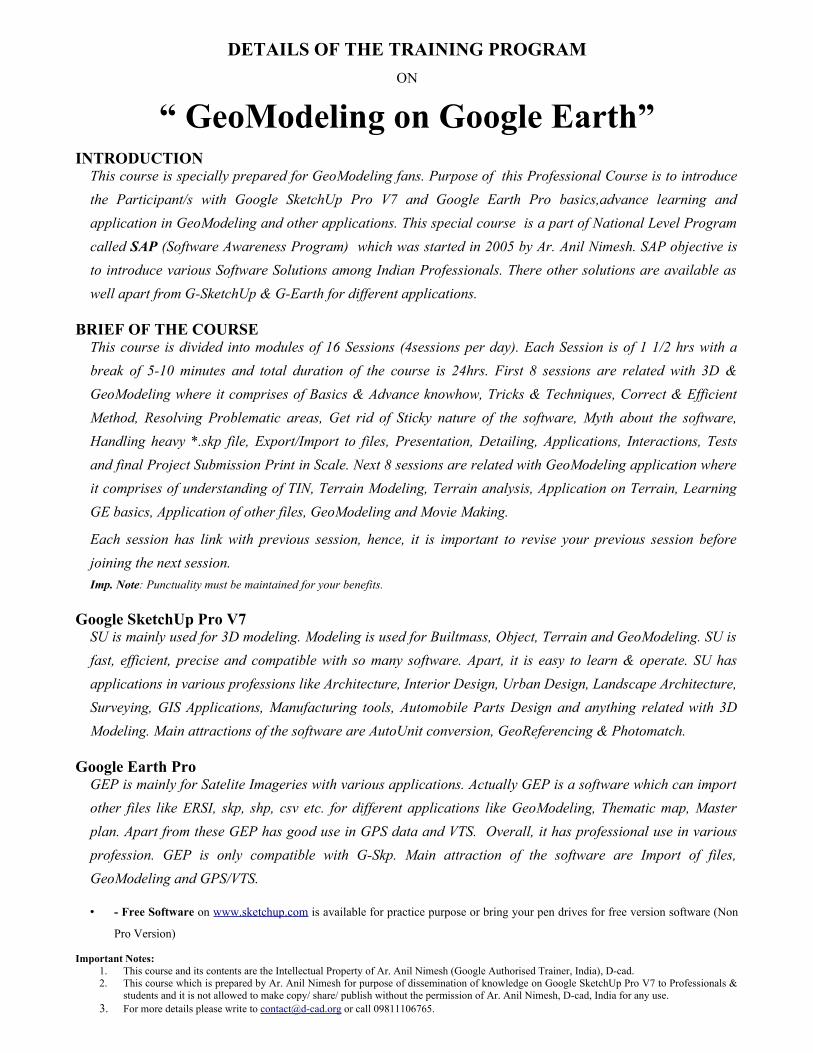
DETAILS OF THE TRAINING PROGRAMON
“ GeoModeling on Google Earth”INTRODUCTION
This course is specially prepared for GeoModeling fans. Purpose of this Professional Course is to introduce the Participant/s with Google SketchUp Pro V7 and Google Earth Pro basics,advance learning and application in GeoModeling and other applications. This special course is a part of National Level Program called SAP (Software Awareness Program) which was started in 2005 by Ar. Anil Nimesh. SAP objective is to introduce various Software Solutions among Indian Professionals. There other solutions are available as well apart from G-SketchUp & G-Earth for different applications.
BRIEF OF THE COURSEThis course is divided into modules of 16 Sessions (4sessions per day). Each Session is of 1 1/2 hrs with a break of 5-10 minutes and total duration of the course is 24hrs. First 8 sessions are related with 3D & GeoModeling where it comprises of Basics & Advance knowhow, Tricks & Techniques, Correct & Efficient Method, Resolving Problematic areas, Get rid of Sticky nature of the software, Myth about the software, Handling heavy *.skp file, Export/Import to files, Presentation, Detailing, Applications, Interactions, Tests and final Project Submission Print in Scale. Next 8 sessions are related with GeoModeling application where it comprises of understanding of TIN, Terrain Modeling, Terrain analysis, Application on Terrain, Learning GE basics, Application of other files, GeoModeling and Movie Making.
Each session has link with previous session, hence, it is important to revise your previous session before joining the next session.Imp. Note: Punctuality must be maintained for your benefits.
Google SketchUp Pro V7SU is mainly used for 3D modeling. Modeling is used for Builtmass, Object, Terrain and GeoModeling. SU is fast, efficient, precise and compatible with so many software. Apart, it is easy to learn & operate. SU has applications in various professions like Architecture, Interior Design, Urban Design, Landscape Architecture, Surveying, GIS Applications, Manufacturing tools, Automobile Parts Design and anything related with 3D Modeling. Main attractions of the software are AutoUnit conversion, GeoReferencing & Photomatch.
Google Earth ProGEP is mainly for Satelite Imageries with various applications. Actually GEP is a software which can import other files like ERSI, skp, shp, csv etc. for different applications like GeoModeling, Thematic map, Master plan. Apart from these GEP has good use in GPS data and VTS. Overall, it has professional use in various profession. GEP is only compatible with G-Skp. Main attraction of the software are Import of files, GeoModeling and GPS/VTS.
• - Free Software on www.sketchup.com is available for practice purpose or bring your pen drives for free version software (Non
Pro Version)
Important Notes:1. This course and its contents are the Intellectual Property of Ar. Anil Nimesh (Google Authorised Trainer, India), D-cad. 2. This course which is prepared by Ar. Anil Nimesh for purpose of dissemination of knowledge on Google SketchUp Pro V7 to Professionals &
students and it is not allowed to make copy/ share/ publish without the permission of Ar. Anil Nimesh, D-cad, India for any use.3. For more details please write to [email protected] or call 09811106765.

Syllabus of Training Coursefor
“ GeoModeling on Google Earth”4 days (6hrs per day)
DAY – ONE (Google SketchUp Pro GeoModeling Basics)
SESSION DESCRIPTION OF THE SESSION DURATION1 Overview & Basics – (A solution for Complex & Efficient work)
1. 2D Modeling (2D+ 3D Basics)2. Introduction & Concept of SketchUp Pro V73. Initial & Preference Setting4. Introduction to Menus & Tools.5. Observing behavior of the software.6. Using of Drawing & Editing Tools for 2D7. Using SketchUp for Drafting8. Drafting Techniques by using Axes & using MKS & FPS together & Learn
Conversion Technique9. Test – 2nos.
1 1/2 hrs
2 Introduction & Applications of Editing Tools & a First step in 3D/3rd Dimension1. Editing Geometry2. Techniques of Editing Tools for 2D3. Observing behavior of Editing tools with different Geometry.4. Multiple use of Editing tools1. Multi-Copies & Array (Rectangular, Angular & Polar) in 3D5. Correct use of Zoom tool in 3D & SketchUp Behavior with 3D object6. Start working in 3rd Dimension7. Making object in 3Dimensions.8. Intersection9. False & Correct method of 3D Mirror10. Test
1 1/2 hrs
3 Introduction to Multi 3D forms & Application of Editing Tools in 3D2. Using of Inbuilt Components (Basics)3. Using of Editing Tools for 3D and its application (Push & Pull and Follow
Me)4. Use of Move, Scale, Offset & Rotate in 3D5. Multi-Copies & Array (Rectangular, Angular & Polar) in 3D6. Making Different roof forms7. How to make a Component & Group - Efficient Working?8. Test
1 1/2 hrs
4 Rendering & Sciography1. Applying material & editing material2. Inserting External Image file & Texture Mapping3. How to handle Shadow?4. Layers for Efficient working5. Selection Option and When to use 'Selection Option'?6. Area Calculation7. How to Handle Mistakes & Work at Intricate level (Correct Approach)8. Continue your previous Project (Get more tips) – Attempt Two
1 1/2 hrs
Important Notes:1. This course and its contents are the Intellectual Property of Ar. Anil Nimesh (Google Authorised Trainer, India), D-cad. 2. This course which is prepared by Ar. Anil Nimesh for purpose of dissemination of knowledge on Google SketchUp Pro V7 to Professionals &
students and it is not allowed to make copy/ share/ publish without the permission of Ar. Anil Nimesh, D-cad, India for any use.3. For more details please write to [email protected] or call 09811106765.

“ GeoModeling on Google Earth”4 days (6hrs per day)
DAY – TWO (Google SketchUp Pro GeoModeling Advance)
5. Help Tool and its application in Plan, Elevations, Sections & Working Drawings1. Introduction and learning Helping tool (like construction line, text, 3D text,
dimension, axes, leader text)2. Make a Typical Housing Unit3. Make wall & Openings4. Detailing of Housing unit5. Placing furniture6. Plan, Elevations & Section/s7. Dimensioning the building8. Export to CAD for Working Drawings9. Import from CAD and making 3D model
1 1/2 hrs
6. Presentation & Print1. Using View tool2. Style & its five properties3. Editing Style & Making new Style4. Sciography & Fog5. Controlling Line/ Section Thickness & Controlling Line Colour6. One point & Two Point Perspective7. Field of View8. Making realistic sky9. Export as Image/ PDF file10. Print from SketchUp & make use of Layout for Advance print
1 1/2 hrs
7. Examining Your Skills & Knowledge – How much you have learnt? (Revision)1. Revising your Basics & Advance knowledge of SketchUp Pro V72. Show your best work3. Discuss your problem/s4. Clarify your confusion/s5. Learning from your mistakes6. How to handle Mistakes?7. Get more Tips, Tricks & Techniques for Efficient working8. Continue with your Project Assignment/ Any Experiment9. Prepare for Final Submission – Attempt Three
1 1/2 hrs
8. Submission of your Project Assignment – Final Attempt1. Make a Multi-Storied Complex in Scale and Unit2. Plan, Elevations & Sections3. Details (More detailing means good print)4. Working with Layer & Components for Efficient work5. Inserting Inbuilt components (Like Trees, Transport etc.)6. Applying Material & External Material7. Applying Realistic Sky8. Sciography & Fog9. Export to CAD – Plan, Elevations & Sections10. Print from SketchUp & Layout
1 1/2 hrs
Important Notes:1. This course and its contents are the Intellectual Property of Ar. Anil Nimesh (Google Authorised Trainer, India), D-cad. 2. This course which is prepared by Ar. Anil Nimesh for purpose of dissemination of knowledge on Google SketchUp Pro V7 to Professionals &
students and it is not allowed to make copy/ share/ publish without the permission of Ar. Anil Nimesh, D-cad, India for any use.3. For more details please write to [email protected] or call 09811106765.
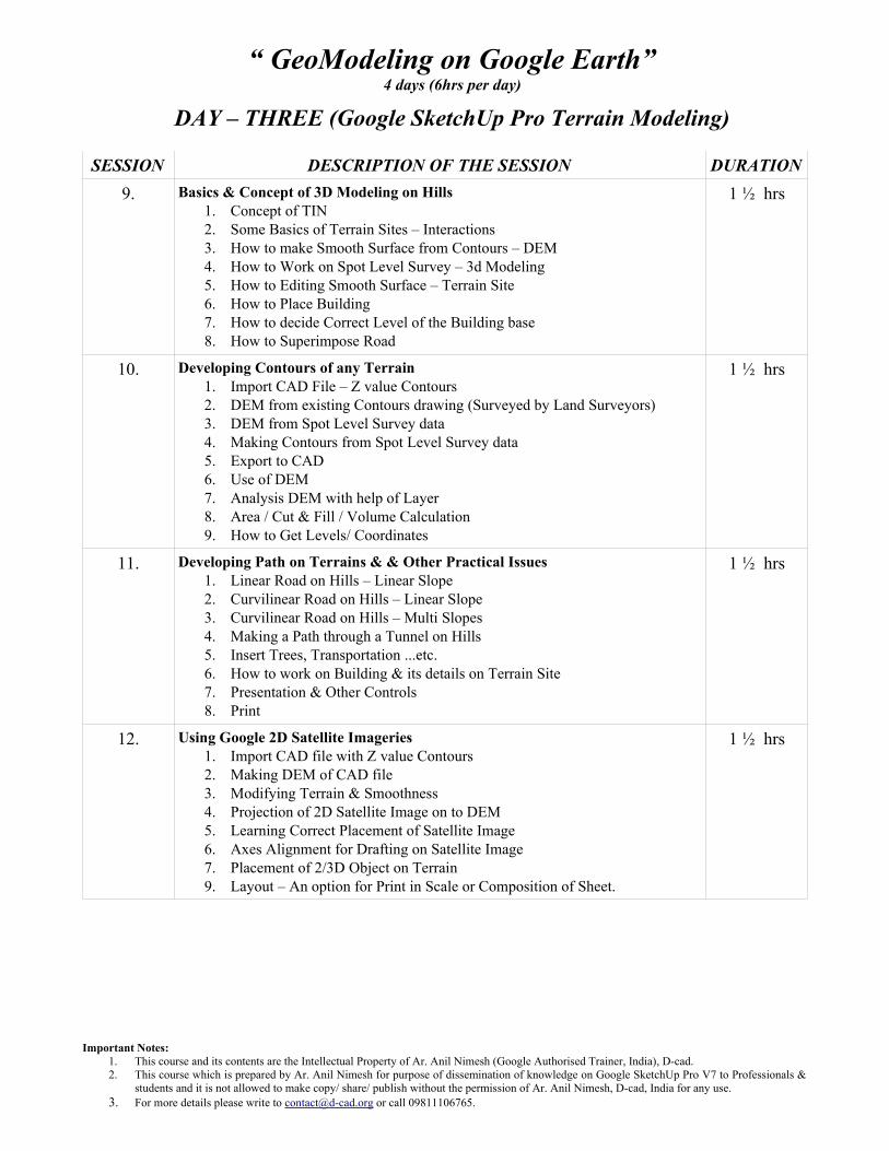
“ GeoModeling on Google Earth”4 days (6hrs per day)
DAY – THREE (Google SketchUp Pro Terrain Modeling)
SESSION DESCRIPTION OF THE SESSION DURATION9. Basics & Concept of 3D Modeling on Hills
1. Concept of TIN2. Some Basics of Terrain Sites – Interactions3. How to make Smooth Surface from Contours – DEM4. How to Work on Spot Level Survey – 3d Modeling5. How to Editing Smooth Surface – Terrain Site6. How to Place Building7. How to decide Correct Level of the Building base8. How to Superimpose Road
1 ½ hrs
10. Developing Contours of any Terrain1. Import CAD File – Z value Contours2. DEM from existing Contours drawing (Surveyed by Land Surveyors)3. DEM from Spot Level Survey data4. Making Contours from Spot Level Survey data5. Export to CAD6. Use of DEM7. Analysis DEM with help of Layer8. Area / Cut & Fill / Volume Calculation9. How to Get Levels/ Coordinates
1 ½ hrs
11. Developing Path on Terrains & & Other Practical Issues1. Linear Road on Hills – Linear Slope2. Curvilinear Road on Hills – Linear Slope3. Curvilinear Road on Hills – Multi Slopes4. Making a Path through a Tunnel on Hills5. Insert Trees, Transportation ...etc.6. How to work on Building & its details on Terrain Site7. Presentation & Other Controls8. Print
1 ½ hrs
12. Using Google 2D Satellite Imageries1. Import CAD file with Z value Contours2. Making DEM of CAD file3. Modifying Terrain & Smoothness4. Projection of 2D Satellite Image on to DEM5. Learning Correct Placement of Satellite Image6. Axes Alignment for Drafting on Satellite Image7. Placement of 2/3D Object on Terrain9. Layout – An option for Print in Scale or Composition of Sheet.
1 ½ hrs
Important Notes:1. This course and its contents are the Intellectual Property of Ar. Anil Nimesh (Google Authorised Trainer, India), D-cad. 2. This course which is prepared by Ar. Anil Nimesh for purpose of dissemination of knowledge on Google SketchUp Pro V7 to Professionals &
students and it is not allowed to make copy/ share/ publish without the permission of Ar. Anil Nimesh, D-cad, India for any use.3. For more details please write to [email protected] or call 09811106765.

“ GeoModeling on Google Earth”4 days (6hrs per day)
DAY – FOUR (Google Earth with application of GeoModeling)
SESSION DESCRIPTION OF THE SESSION DURATION13. Concept & Basics
1. Introduction & Concept2. Basics on Geographical info3. Basics of GEP4. Menus, Tools & Initial Settings5. Mouse Buttons Function6. North Point, Latitude & Longitude7. Compatibility8. Search9. Layers
1 ½ hrs
14. Advance Usage of GEP1. Latitude, Longitude & Elevation2. Import Map & Shape files3. Importing GPS Data4. Fly Through/ Movie Maker5. Measurement6. Placemark7. Copy Image8. Email/ Share
1 ½ hrs
15. Combining G-SketchUp Pro & G-Earth Pro1. Basics of Geo Referencing2. Placing Master Plan/ Map on GEP3. Import GeoTiff from GEP4. Utilization of GeoTiff Data of GEP5. Geo Modeling in G-SketchUp Pro6. Exporting Geo-Model to GEP7. Using Help Tool for Model Info
1 ½ hrs
16. Submission of your Project Assignment – Final Attempt1. Import GEP GeoTiff2. Mark your site3. Find out Coordinates & Elevations4. Trace Object & Place or Make your Object & Place on DEM5. Place Components6. Area / Cut & Fill Calculation7. Place your object on GEP8. Submit your Work9. Print
1 ½ hrs
Total 16 Sessions 24 hrs
Important Notes:1. This course and its contents are the Intellectual Property of Ar. Anil Nimesh (Google Authorised Trainer, India), D-cad. 2. This course which is prepared by Ar. Anil Nimesh for purpose of dissemination of knowledge on Google SketchUp Pro V7 to Professionals &
students and it is not allowed to make copy/ share/ publish without the permission of Ar. Anil Nimesh, D-cad, India for any use.3. For more details please write to [email protected] or call 09811106765.