2.1 - agronomic units jan2015 - frogs - agronomic units_jan2015.pdf · des produits utiles - des...
TRANSCRIPT
DES PRODUITS UTILES - DES ENTREPRISES RESPONSABLES
UIPP Environmental Methodology Working Group
2.1 - Agronomic Units
FROGS (French Refinement Of Groundwater Scenarios) UIPP Training
Paris, 22-23 January 2015
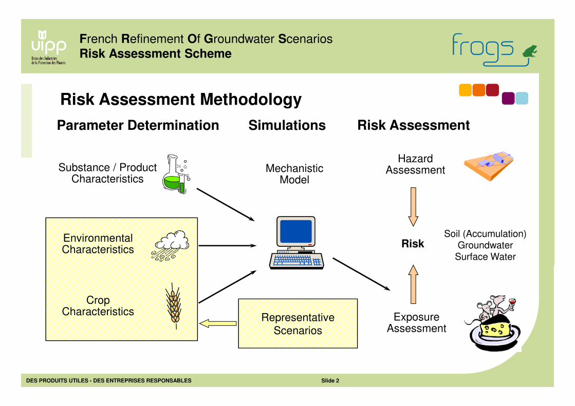
MechanisticModel
ExposureAssessment
EnvironmentalCharacteristics
Substance / ProductCharacteristics
CropCharacteristics
HazardAssessment
Risk
Representative
Scenarios
Soil (Accumulation) Groundwater
Surface Water
Parameter Determination Risk AssessmentSimulations
French Refinement Of Groundwater Scenarios
Risk Assessment Scheme
Risk Assessment Methodology
DES PRODUITS UTILES - DES ENTREPRISES RESPONSABLES Slide 2
DES PRODUITS UTILES - DES ENTREPRISES RESPONSABLES Slide 3
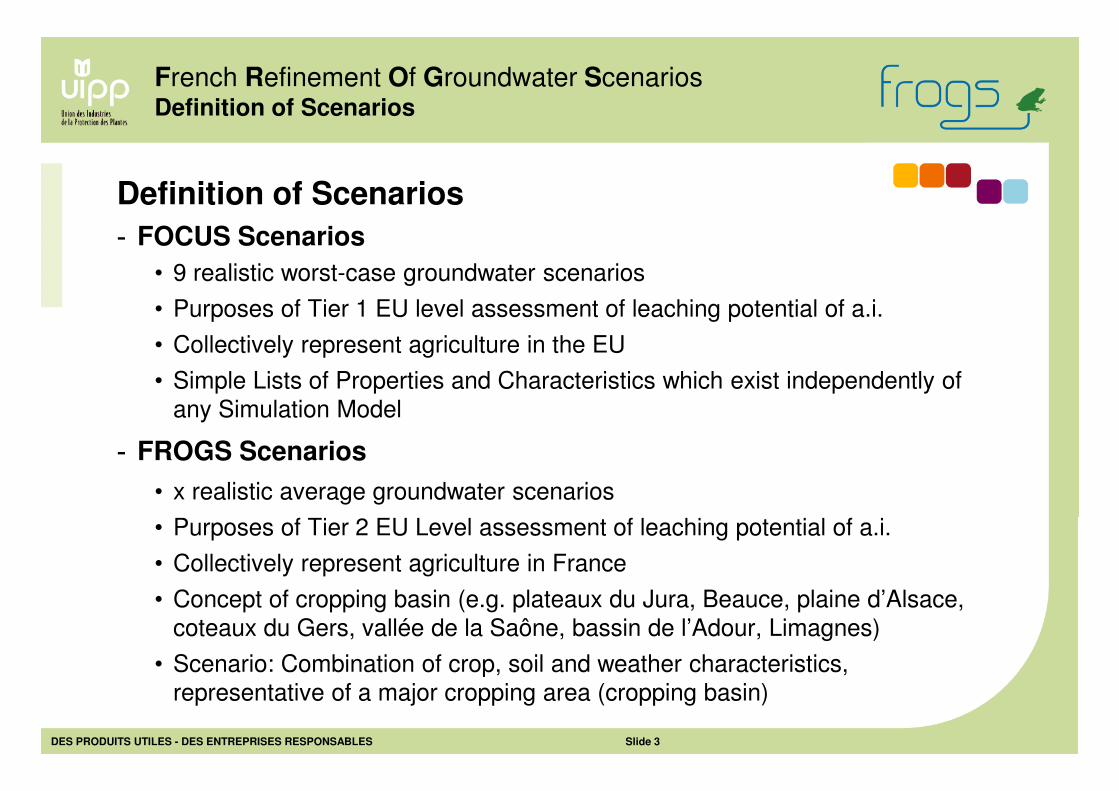
Definition of Scenarios
French Refinement Of Groundwater ScenariosDefinition of Scenarios
- FOCUS Scenarios
• 9 realistic worst-case groundwater scenarios
• Purposes of Tier 1 EU level assessment of leaching potential of a.i.
• Collectively represent agriculture in the EU
• Simple Lists of Properties and Characteristics which exist independently of
any Simulation Model
- FROGS Scenarios
• x realistic average groundwater scenarios
• Purposes of Tier 2 EU Level assessment of leaching potential of a.i.
• Collectively represent agriculture in France
• Concept of cropping basin (e.g. plateaux du Jura, Beauce, plaine d’Alsace,
coteaux du Gers, vallée de la Saône, bassin de l’Adour, Limagnes)
• Scenario: Combination of crop, soil and weather characteristics,
representative of a major cropping area (cropping basin)
DES PRODUITS UTILES - DES ENTREPRISES RESPONSABLES Slide 4
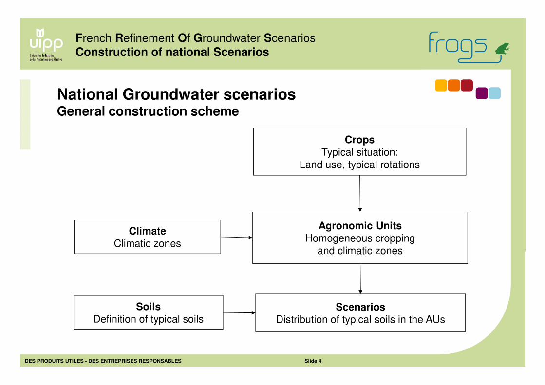
French Refinement Of Groundwater Scenarios
Construction of national Scenarios
National Groundwater scenariosGeneral construction scheme
Crops
Typical situation:
Land use, typical rotations
Agronomic Units
Homogeneous cropping
and climatic zones
Soils
Definition of typical soilsScenarios
Distribution of typical soils in the AUs
Climate
Climatic zones
DES PRODUITS UTILES - DES ENTREPRISES RESPONSABLES Slide 5
• Land use, crop characteristics and rotations can be described by a set of
typical representative situations
• Need for representative situations, in necessary and sufficient number
• Scenarios compatible with assessment objectives and information simplicity
for modeling
Concept of Agronomic Unit (AU)
- Basic assumptions
French Refinement Of Groundwater Scenarios
Agronomic Units
• Crop distribution (relevant crops, proportion of cultivated surfaces)
• Crop characteristics (dates of key growth stages)
• Rotations
• Climate pattern
• Agronomic Unit = Cropping basin in the GW Risk assessment context
- AU definition
Geographic area fulfilling homogeneity criteria:
DES PRODUITS UTILES - DES ENTREPRISES RESPONSABLES Slide 6
• Agricultural census 2000 (“Recensement agricole 2000”)
• Crop cultivated surface at “canton” scale; data available for 3540 cantons
Information used
- Agricultural statistics
French Refinement Of Groundwater Scenarios
Agronomic Units
• Small agricultural regions (“Petites régions agricoles”: PRA)
• Cropping basins: pedologic / agroclimatic reference documents
• Hydro-Ecoregions
• Climatic zones
- Environmental zoning
Information on land use:
Existing zonings reflecting environmental characteristics:
DES PRODUITS UTILES - DES ENTREPRISES RESPONSABLES Slide 7
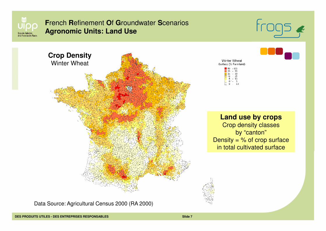
Crop DensityWinter Wheat
French Refinement Of Groundwater Scenarios
Agronomic Units: Land Use
Data Source: Agricultural Census 2000 (RA 2000)
Land use by cropsCrop density classes
by “canton”
Density = % of crop surface in total cultivated surface
DES PRODUITS UTILES - DES ENTREPRISES RESPONSABLES Slide 8
• Permanent environmental characteristics (geology, geomorphology,
topography, soil, climate)
• Variable characteristics in a decade time step (Farming systems, land use,
farm size, etc.)
Information used (continued)
- Small Agricultural Regions (PRA)
French Refinement Of Groundwater Scenarios
Agronomic Units
• 20 cropping basins
• Basins delimited by aggregation of 69 PRAs (1 to 7 PRA per basin)
• 41 soil types
• Soil types assigned to relevant PRAs
- Cropping Basins
713 Geographic areas delimited on the basis of two types of characteristics:
Example: Pedologic repository for western France (4 administrative regions)
This method of PRA aggregation was applied to other areas
DES PRODUITS UTILES - DES ENTREPRISES RESPONSABLES Slide 9
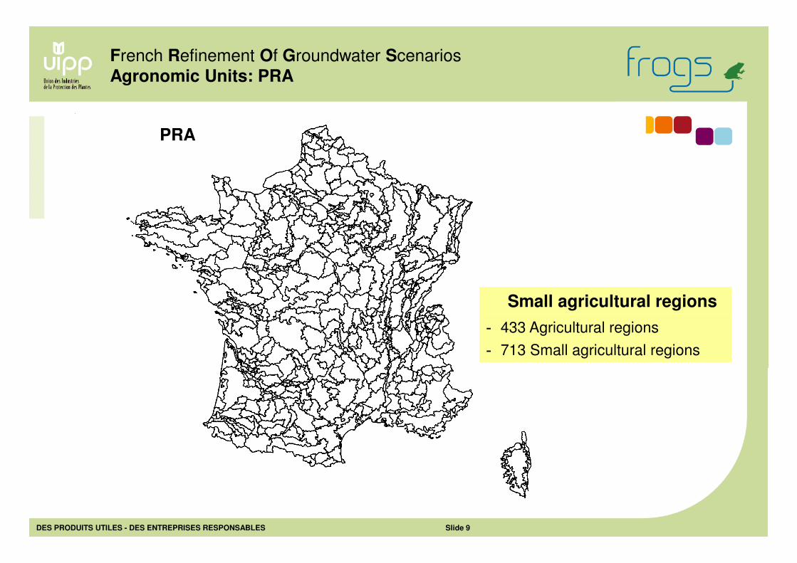
French Refinement Of Groundwater Scenarios
Agronomic Units: PRA
Small agricultural regions
- 433 Agricultural regions
- 713 Small agricultural regions
PRA
DES PRODUITS UTILES - DES ENTREPRISES RESPONSABLES Slide 10
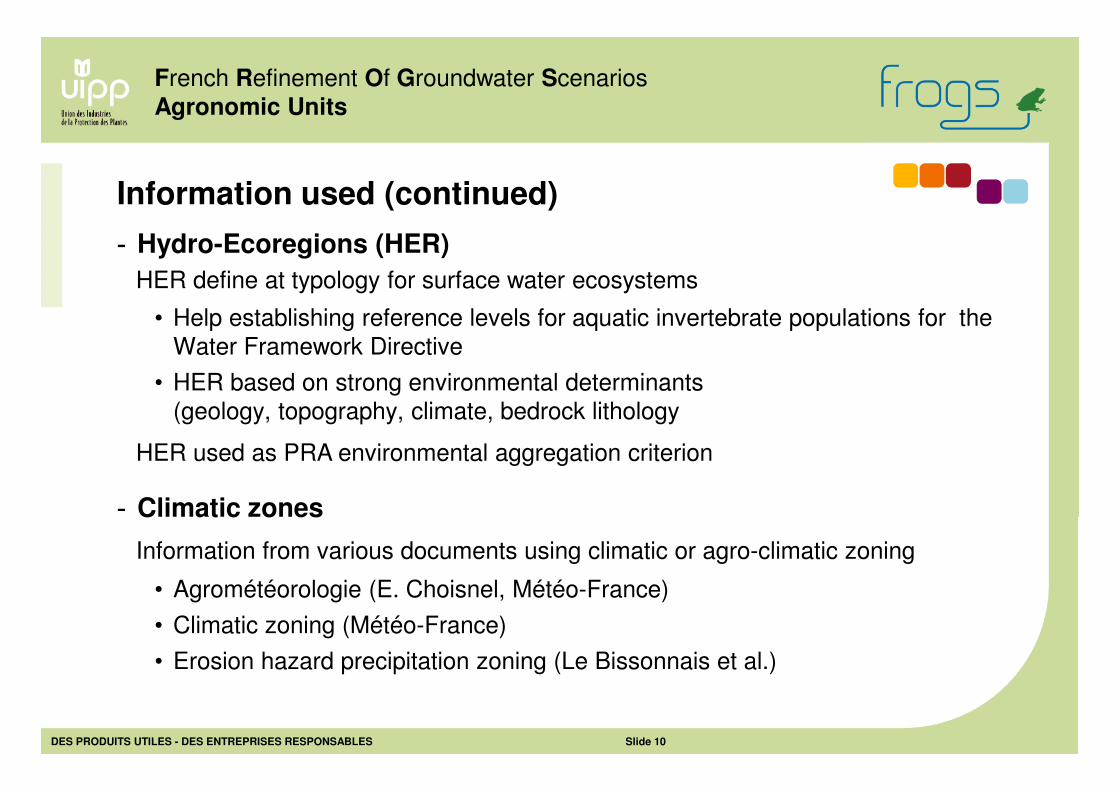
• Help establishing reference levels for aquatic invertebrate populations for the
Water Framework Directive
• HER based on strong environmental determinants
(geology, topography, climate, bedrock lithology
Information used (continued)
- Hydro-Ecoregions (HER)
French Refinement Of Groundwater Scenarios
Agronomic Units
• Agrométéorologie (E. Choisnel, Météo-France)
• Climatic zoning (Météo-France)
• Erosion hazard precipitation zoning (Le Bissonnais et al.)
- Climatic zones
Information from various documents using climatic or agro-climatic zoning
HER define at typology for surface water ecosystems
HER used as PRA environmental aggregation criterion
DES PRODUITS UTILES - DES ENTREPRISES RESPONSABLES Slide 11
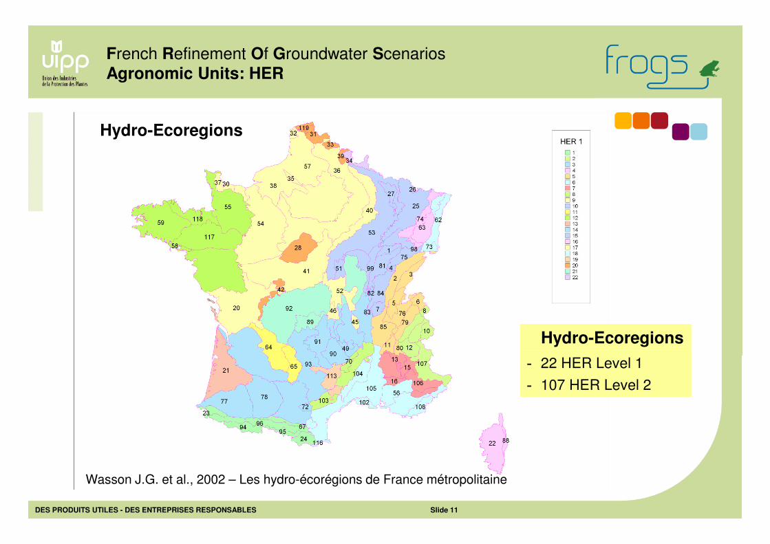
French Refinement Of Groundwater Scenarios
Agronomic Units: HER
Hydro-Ecoregions
- 22 HER Level 1
- 107 HER Level 2
Hydro-Ecoregions
Wasson J.G. et al., 2002 – Les hydro-écorégions de France métropolitaine
DES PRODUITS UTILES - DES ENTREPRISES RESPONSABLES Slide 12
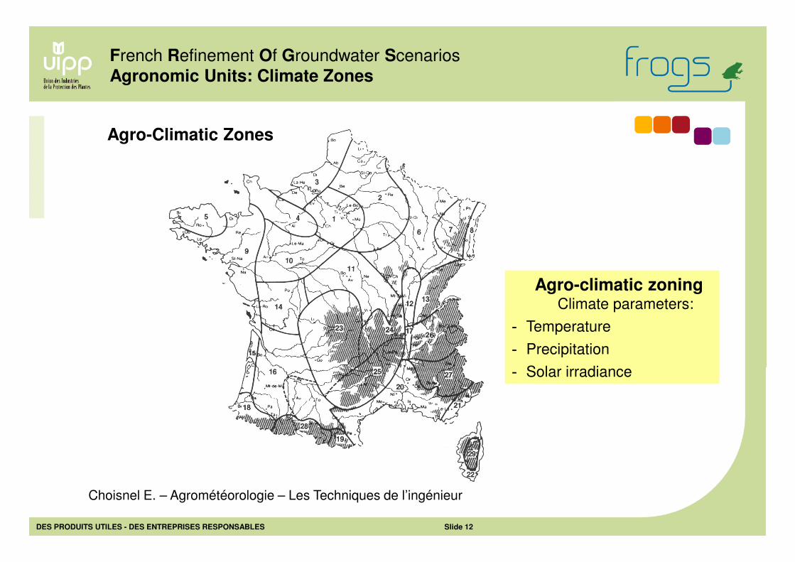
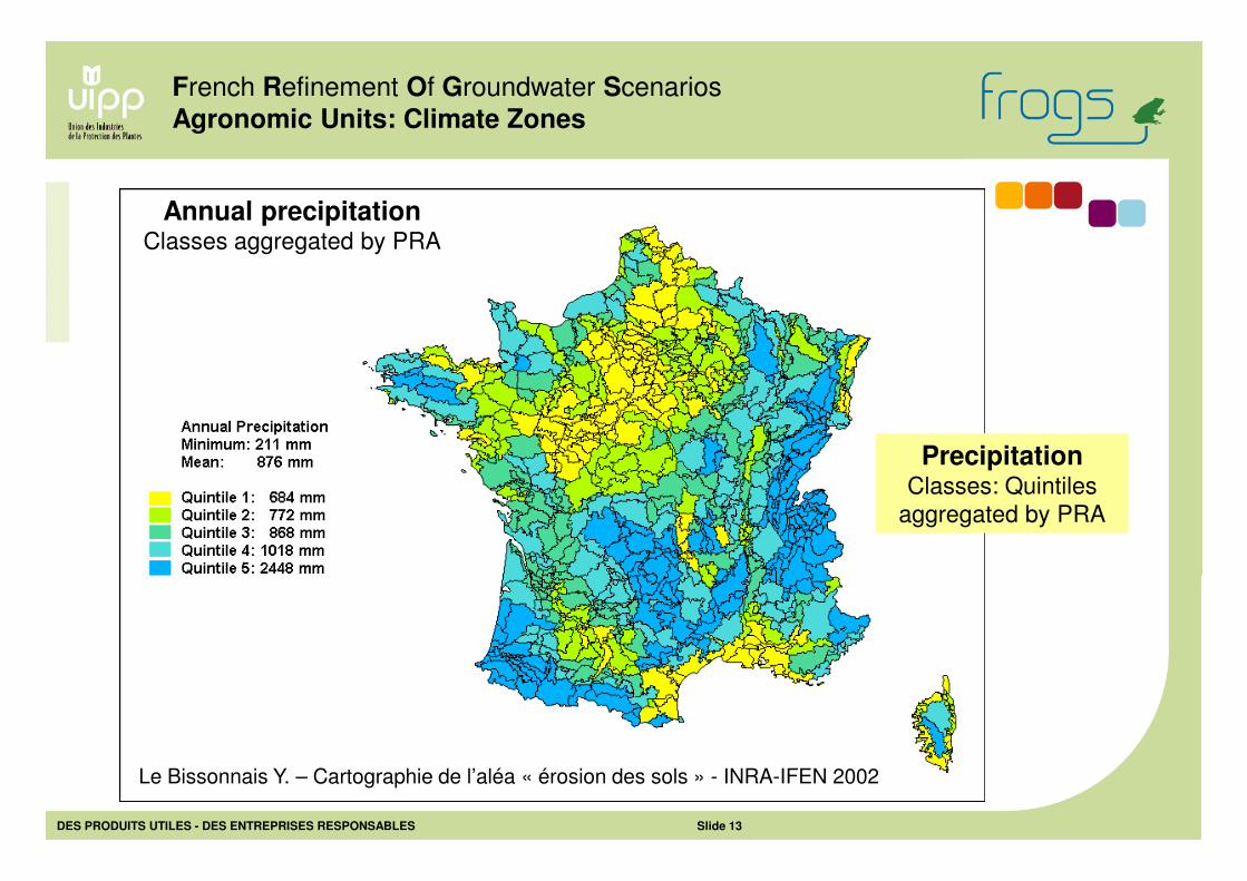
French Refinement Of Groundwater Scenarios
Agronomic Units: Climate Zones
Agro-Climatic Zones
Choisnel E. – Agrométéorologie – Les Techniques de l’ingénieur
Agro-climatic zoningClimate parameters:
- Temperature
- Precipitation
- Solar irradiance
DES PRODUITS UTILES - DES ENTREPRISES RESPONSABLES Slide 13
French Refinement Of Groundwater Scenarios
Agronomic Units: Climate Zones
Annual precipitation Classes aggregated by PRA
Le Bissonnais Y. – Cartographie de l’aléa « érosion des sols » - INRA-IFEN 2002
PrecipitationClasses: Quintiles
aggregated by PRA
DES PRODUITS UTILES - DES ENTREPRISES RESPONSABLES Slide 14
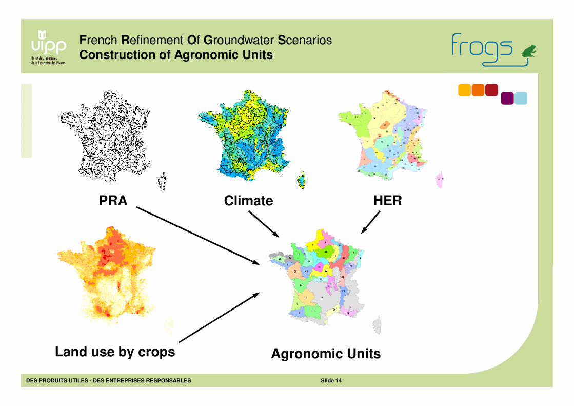
French Refinement Of Groundwater Scenarios
Construction of Agronomic Units
Land use by crops
Climate HERPRA
Agronomic Units
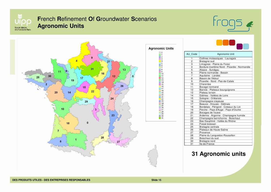
DES PRODUITS UTILES - DES ENTREPRISES RESPONSABLES Slide 15
1 Collines molassiques - Lauragais
2 Bretagne sud
3 Limagnes - Plaine du Forez
4 Bordure maritime Nord - Picardie - Normandie
5 Alsace - Sundgau
6 Plaine normande - Bessin
7 Aquitaine - Landes
8 Bassin de l'Adour
9 Picardie - Nord - Pas-de-Calais
10 Charentes
11 Bocage normand
12 Barrois - Plateaux bourguignons
13 Plateau lorrain
14 Gâtines - Vallées de Loire
15 Sologne - Orléanais
16 Champagne crayeuse
17 Beauce - Drouais - Gâtinais
18 Bordelais - Périgord - Coteaux du Lot
19 Perche - Pays d'Auge - Pays d'Ouche
20 Bocages de l'ouest
21 Ardenne - Argonne - Champagne humide
22 Champagne berrichonne - Boischaut
23 Bas Dauphiné - Vallée du Rhône
24 Fossé bressan
25 Bretagne centrale
26 Plateaux de Haute-Saône
27 Provence
28 Plaine du Languedoc-Roussillon
29 Boischaut du sud
30 Bretagne nord
31 Ile-de-France
Agronomic UnitAU_Code
French Refinement Of Groundwater Scenarios
Agronomic Units
31 Agronomic units
DES PRODUITS UTILES - DES ENTREPRISES RESPONSABLES Slide 16
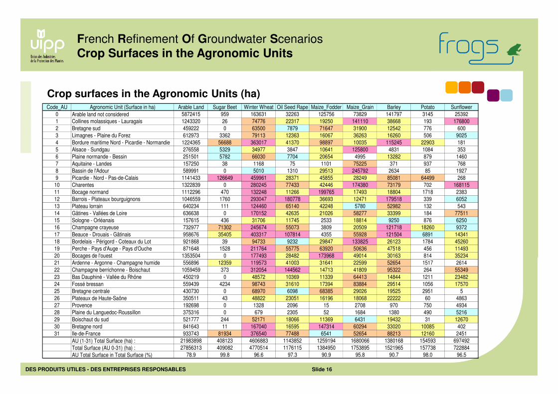
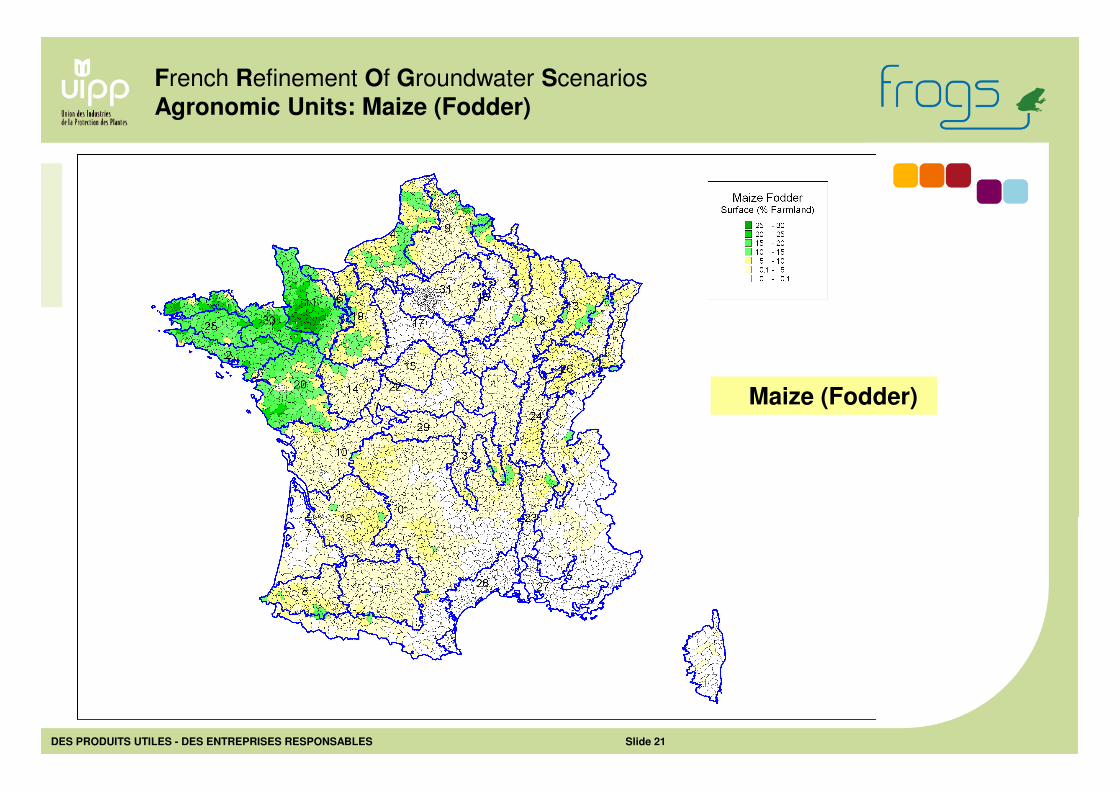
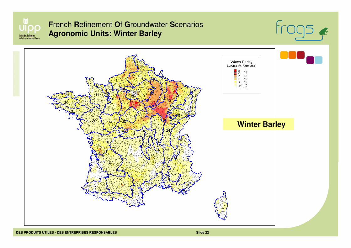
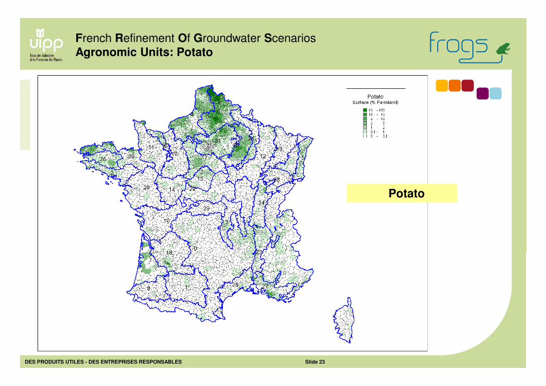
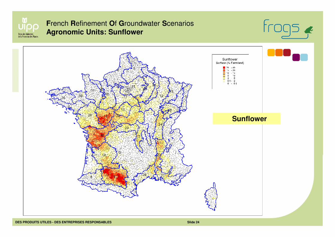
Crop surfaces in the Agronomic Units (ha)Code_AU Agronomic Unit (Surface in ha) Arable Land Sugar Beet Winter Wheat Oil Seed Rape Maize_Fodder Maize_Grain Barley Potato Sunflower
0 Arable land not considered 5872415 959 163631 32263 125756 73829 141797 3145 25392
1 Collines molassiques - Lauragais 1243320 26 74776 22317 19250 141110 38668 193 176800
2 Bretagne sud 459222 0 63500 7879 71647 31900 12542 776 600
3 Limagnes - Plaine du Forez 612973 3362 79113 12363 16067 36263 16260 506 9025
4 Bordure maritime Nord - Picardie - Normandie 1224365 56688 363017 41370 98897 10035 115245 22903 181
5 Alsace - Sundgau 276558 5329 34977 3847 10641 125800 4831 1084 353
6 Plaine normande - Bessin 251501 5782 66030 7704 20654 4995 13282 879 1460
7 Aquitaine - Landes 157250 38 1168 75 1101 75225 371 937 768
8 Bassin de l'Adour 589991 0 5010 1310 29513 245792 2634 85 1927
9 Picardie - Nord - Pas-de-Calais 1141433 126649 459961 28371 45855 28249 85081 64499 268
10 Charentes 1322839 0 280245 77433 42446 174380 73179 702 168115
11 Bocage normand 1112296 470 132248 11266 199765 17493 18804 1718 2383
12 Barrois - Plateaux bourguignons 1046559 1760 293047 180778 36693 12471 179518 339 6052
13 Plateau lorrain 640234 111 124460 65140 42248 5780 52982 132 543
14 Gâtines - Vallées de Loire 636638 0 170152 42635 21026 58277 33399 184 77511
15 Sologne - Orléanais 157615 436 31706 11745 2533 18814 9250 876 6250
16 Champagne crayeuse 732977 71302 245674 55073 3809 20509 121718 18260 9372
17 Beauce - Drouais - Gâtinais 958676 35405 403317 107814 4355 55928 121504 6891 14341
18 Bordelais - Périgord - Coteaux du Lot 921868 39 94733 9232 29847 133825 26123 1784 45260
19 Perche - Pays d'Auge - Pays d'Ouche 871648 1528 211764 55775 63920 50636 47518 456 11493
20 Bocages de l'ouest 1353504 0 177493 28482 173968 49014 30163 814 35234
21 Ardenne - Argonne - Champagne humide 556896 12359 119573 41003 31641 22599 52654 1517 2614
22 Champagne berrichonne - Boischaut 1059459 373 312054 144562 14713 41809 95322 264 55349
23 Bas Dauphiné - Vallée du Rhône 450219 0 48572 10369 11339 64413 14844 1211 23482
24 Fossé bressan 559439 4234 98743 31610 17394 83884 29514 1056 17570
25 Bretagne centrale 430730 0 68970 6098 68385 29026 19525 2951 5
26 Plateaux de Haute-Saône 350511 43 48822 23051 16196 18068 22222 60 4863
27 Provence 192698 0 1328 2096 15 2708 970 750 4934
28 Plaine du Languedoc-Roussillon 375316 0 679 2305 52 1684 1380 490 5216
29 Boischaut du sud 521777 244 52171 18066 11369 6431 19432 31 12670
30 Bretagne nord 841643 11 167040 16595 147314 60294 33020 10085 402
31 Ile-de-France 933743 81934 376540 77488 6541 52654 88213 12160 2451
AU (1-31) Total Surface (ha) : 21983898 408123 4606883 1143852 1259194 1680066 1380168 154593 697492
Total Surface (AU 0-31) (ha) : 27856313 409082 4770514 1176115 1384950 1753895 1521965 157738 722884
AU Total Surface in Total Surface (%) 78.9 99.8 96.6 97.3 90.9 95.8 90.7 98.0 96.5
French Refinement Of Groundwater Scenarios
Crop Surfaces in the Agronomic Units
DES PRODUITS UTILES - DES ENTREPRISES RESPONSABLES Slide 17
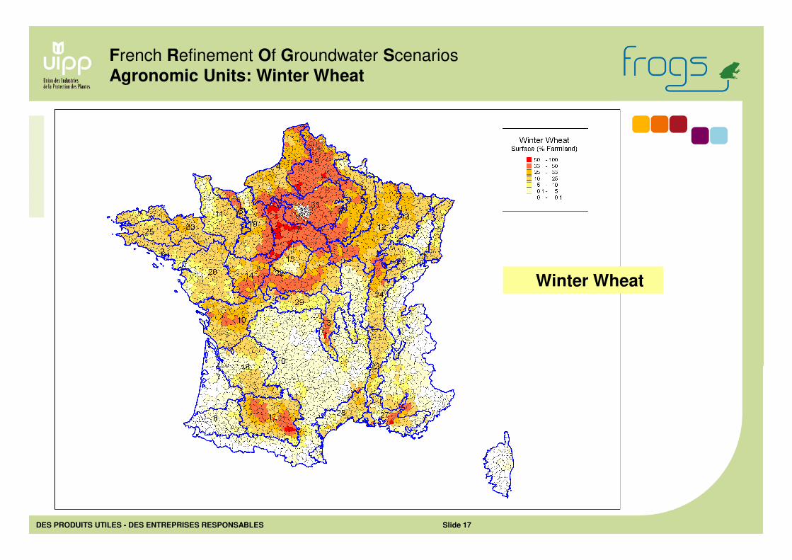
French Refinement Of Groundwater Scenarios
Agronomic Units: Winter Wheat
Winter Wheat
DES PRODUITS UTILES - DES ENTREPRISES RESPONSABLES Slide 18
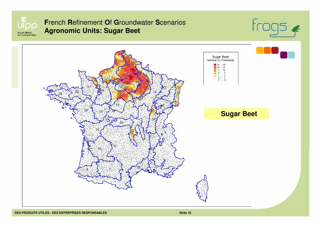
French Refinement Of Groundwater Scenarios
Agronomic Units: Sugar Beet
Sugar Beet
DES PRODUITS UTILES - DES ENTREPRISES RESPONSABLES Slide 19
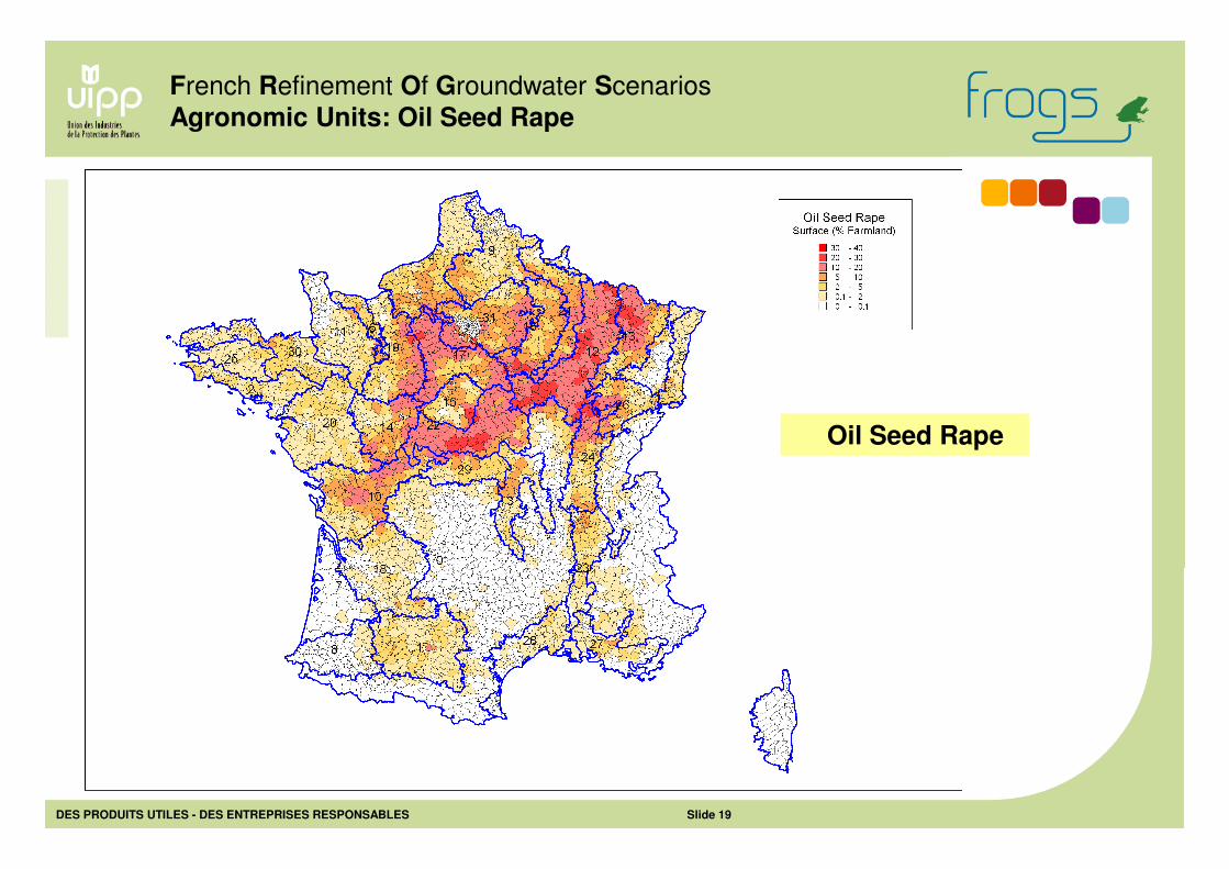
French Refinement Of Groundwater Scenarios
Agronomic Units: Oil Seed Rape
Oil Seed Rape
DES PRODUITS UTILES - DES ENTREPRISES RESPONSABLES Slide 20
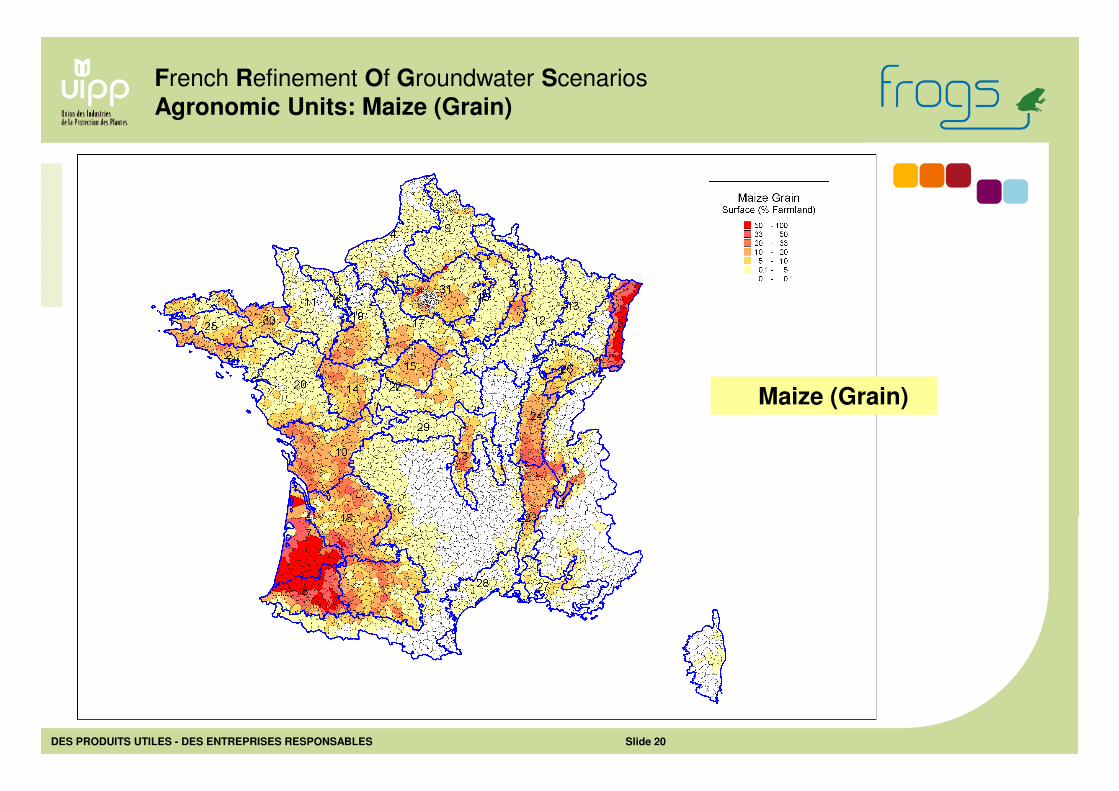
French Refinement Of Groundwater Scenarios
Agronomic Units: Maize (Grain)
Maize (Grain)
DES PRODUITS UTILES - DES ENTREPRISES RESPONSABLES Slide 21
French Refinement Of Groundwater Scenarios
Agronomic Units: Maize (Fodder)
Maize (Fodder)
DES PRODUITS UTILES - DES ENTREPRISES RESPONSABLES Slide 22
French Refinement Of Groundwater Scenarios
Agronomic Units: Winter Barley
Winter Barley
DES PRODUITS UTILES - DES ENTREPRISES RESPONSABLES Slide 23
French Refinement Of Groundwater Scenarios
Agronomic Units: Potato
Potato
DES PRODUITS UTILES - DES ENTREPRISES RESPONSABLES Slide 24
French Refinement Of Groundwater Scenarios
Agronomic Units: Sunflower
Sunflower
DES PRODUITS UTILES - DES ENTREPRISES RESPONSABLES Slide 25
• Crops: Surfaces, growth parameters: specific AU data
• Rotations: One representative rotation defined for each primary crop in a AU
• Soils: Relevant soils assigned to each AU (not all soils considered in a AU)
• Climate: One specific set of weather records associated to a AU
Summary
- AU characterization (next presentations)
• AUs defined for 8 major arable crops
• AUs validly applicable to other arable crops
• AUs not suitable for perennial crops
- AU Validity Domain
Agronomic Units reflect typical agronomic situations for arable crops
- AU and Scenarios
• Each AU determines the relevant weather data set, crop parameters and
rotation for a primary crop
French Refinement Of Groundwater Scenarios
Agronomic Units: Summary
DES PRODUITS UTILES - DES ENTREPRISES RESPONSABLES Slide 26
French Refinement Of Groundwater Scenarios
Thanks for your attention
It is time to get out of the ditch!