20140225 rip overview_combined
TRANSCRIPT

TulsaDistrict
Albuquerque District
Fort WorthDistrict
Galveston Distric
t
Littl
e R
ock
Dis
tric
t
M e x i c oM e x i c o
O k l a h o m aO k l a h o m a
N e w M e x i c oN e w M e x i c o
Federal Levee
Non-Federal Levee
Federal Channel
Bank Protection
USACE Lakes
Structures OverviewFort Worth District
0 40 8020Miles
Geospatial Services SectionEli Kangas, ChiefJennifer Holland, Geographer
4/2/2014

A n d e r s o n C o u n t y
F r e e s t o n e C o u n t y
L e o n C o u n t y
N a v a r r o C o u n t y
H o u s t o n C o u n t yL i m e s t o n e
C o u n t y
3
1
2
Non-Federal Levees123 Anderson LID 2 Trinity LB
Anderson LID 1 Cedar Lake LBHenderson LID 3 Trinity LB
H o u s t o n C o u n t y
L e o n C o u n t y
N a v a r r o C o u n t y
A n d e r s o n C o u n t y
C h e r o k e e C o u n t y
H e n d e r s o n C o u n t y
F r e e s t o n e C o u n t y
L i m e s t o n e C o u n t y
S m i t h C o u n t y
E l l i s C o u n t y
R o b e r t s o n C o u n t y
T r i n i t y C o u n t y
V a n Z a n d t C o u n t y
K a u f m a n C o u n t y
F a l l s C o u n t y
M a d i s o n C o u n t y
H i l l C o u n t y
W a l k e r C o u n t y
0 4 82Miles
Eligible for RIP
Not Eligible for RIP
Geospatial Services SectionEli Kangas, ChiefJennifer Holland, Geographer
4/1/2014
RIP StatusFort Worth District
Anderson County, Texas
This product is reproduced from geospatial informationprepared by the U.S. Army Corps of Engineers. GIS data and
product accuracy may vary. Data may be: developed fromsources of differing accuracy, accurate only at certain scales,based on modeling or interpretation, incomplete while being
created or revised, etc. Using GIS products for purposes otherthan those for which they were created may yield inaccurate ormisleading results. The Corps of Engineers reserves the right to
correct, update, modify, or replace GIS products withoutnotification. For more information contact the Fort Worth District
Geospatial Office.

A t a s c o s a C o u n t y
W i l s o n C o u n t y
B e x a r C o u n t y
1
2
Federal Channels12 Pleasanton Flood Channel
Poteet Channel
A t a s c o s a C o u n t y
B e x a r C o u n t y
W i l s o n C o u n t y
F r i o C o u n t y
M e d i n a C o u n t y
K a r n e s C o u n t y
0 1.5 30.75Miles
Eligible for RIP
Not Eligible for RIP
Geospatial Services SectionEli Kangas, ChiefJennifer Holland, Geographer
4/1/2014
RIP StatusFort Worth District
Atascosa County, Texas
This product is reproduced from geospatial informationprepared by the U.S. Army Corps of Engineers. GIS data and
product accuracy may vary. Data may be: developed fromsources of differing accuracy, accurate only at certain scales,based on modeling or interpretation, incomplete while being
created or revised, etc. Using GIS products for purposes otherthan those for which they were created may yield inaccurate ormisleading results. The Corps of Engineers reserves the right to
correct, update, modify, or replace GIS products withoutnotification. For more information contact the Fort Worth District
Geospatial Office.

B a s t r o p C o u n t y
F a y e t t e C o u n t y
WWiillllooww CCrreeeekk
GG aa zz ll ee yy CC rr ee ee kk
JJ DD CC rreeeekk
Hunt Branch
Hunt Branch
AA ll uumm
CCrr ee
ee kk
WW
oo ll ff CC rr ee ee kk
Wolf C
reekW
olf Creek
1
Bank Protection1 Colorado River Channel
B a s t r o p C o u n t y
F a y e t t e C o u n t y
L e e C o u n t y
0 0.6 1.20.3Miles
Eligible for RIP
Not Eligible for RIP
Geospatial Services SectionEli Kangas, ChiefJennifer Holland, Geographer
4/1/2014
RIP StatusFort Worth District
Bastrop County, Texas
This product is reproduced from geospatial informationprepared by the U.S. Army Corps of Engineers. GIS data and
product accuracy may vary. Data may be: developed fromsources of differing accuracy, accurate only at certain scales,based on modeling or interpretation, incomplete while being
created or revised, etc. Using GIS products for purposes otherthan those for which they were created may yield inaccurate ormisleading results. The Corps of Engineers reserves the right to
correct, update, modify, or replace GIS products withoutnotification. For more information contact the Fort Worth District
Geospatial Office.

B e x a r C o u n t y
SS aa nn AAnn tt oo
nn ii oo RR
ii vvee rr
AA llaazzaann CCrreeeek k
San
Pedr
o C
reek
San
Pedr
o C
reek
1
2
Federal Channel1 San Antonio Channel2 San Antonio Channel
B e x a r C o u n t y
0 0.45 0.90.225Miles
Eligible for RIP
Not Eligible for RIP
Geospatial Services SectionEli Kangas, ChiefJennifer Holland, Geographer
4/1/2014
RIP StatusFort Worth District
Bexar County, Texas
This product is reproduced from geospatial informationprepared by the U.S. Army Corps of Engineers. GIS data and
product accuracy may vary. Data may be: developed fromsources of differing accuracy, accurate only at certain scales,based on modeling or interpretation, incomplete while being
created or revised, etc. Using GIS products for purposes otherthan those for which they were created may yield inaccurate ormisleading results. The Corps of Engineers reserves the right to
correct, update, modify, or replace GIS products withoutnotification. For more information contact the Fort Worth District
Geospatial Office.

C o o k e C o u n t y
PPeeccaann CCr reeeekk
WW hhee ee ll ee rr CCrr ee ee kk
RR ee dd mm oo nn dd BB rr aa nn cc hh
EE ll mm FF oo rr kk TT rr ii nn ii tt yy RR ii vveerr
SS cc oo tt tt CCrreeeekk
DDoozziiee rr CCrreeeekk
RRoocckk CCrreeeekk
MM oo nnttaa gguu ee CCrreeee kk
1
2
Federal Channel2 Wheeler Creek Channel
1 Leonard Park Elm Fork LB
Non-Federal Levee
C o o k e C o u n t y
L o v e C o u n t y
0 0.6 1.20.3Miles
Eligible for RIP
Not Eligible for RIP
Geospatial Services SectionEli Kangas, ChiefJennifer Holland, Geographer
4/1/2014
RIP StatusFort Worth District
Cooke County, Texas
This product is reproduced from geospatial informationprepared by the U.S. Army Corps of Engineers. GIS data and
product accuracy may vary. Data may be: developed fromsources of differing accuracy, accurate only at certain scales,based on modeling or interpretation, incomplete while being
created or revised, etc. Using GIS products for purposes otherthan those for which they were created may yield inaccurate ormisleading results. The Corps of Engineers reserves the right to
correct, update, modify, or replace GIS products withoutnotification. For more information contact the Fort Worth District
Geospatial Office.

D a l l a s C o u n t y
T a r r a n t C o u n t y
K a u f m a n C o u n t y
R o c k w a l l C o u n t y
E l l i s C o u n t y
C o l l i n C o u n t y
D e n t o n C o u n t y
J o h n s o n C o u n t y
5
1216
14
13
7
8
3
17
11
9
10
18
1
2
4
15
22
20
19
216
Non-Federal Levee8 Dallas LID 1 Trinity RB
1 Bois D’Arc Levee Trinity LBFederal Levee
Federal Channel
Bank Protection
2 Central WWTP Trinity RB
9 Dallas LID 14 Trinity RB10 Dallas LID 2 Trinity RB
3 East Dallas Levee Trinity LB4 Irving Levee (IFCD-1 East)5 Irving Levee (IFCD-1 West)
11 Kaufman LID 15 East Fork Trinity LB12 Kaufman LID 6 East Fork Trinity RB13 Kaufman LID 8 East Fork Trinity RB
6 Rochester Levee Trinity LB7 West Dallas Levee Trinity RB
14 Dallas Floodway Channel15 Delaware Creek Channel16 Dry Branch Channel17 Duck Creek Channel18 Hutton Branch Channel19 Ten Mile Creek Channel
20 Cottonwook Creek Bank Protection
21 Grand Prairie Sanitary LandfillBank Protection
22 Bank Protection, Meyers Rd
D a l l a s C o u n t y
E l l i s C o u n t y
T a r r a n t C o u n t y
D e n t o n C o u n t y
C o l l i n C o u n t y
K a u f m a n C o u n t y
H u n t C o u n t y
J o h n s o n C o u n t y
W i s e C o u n t y
N a v a r r o C o u n t y
H i l l C o u n t y
R o c k w a l l C o u n t y
F a n n i n C o u n t y
0 3.5 71.75Miles
Eligible for RIP
Not Eligible for RIP
Geospatial Services SectionEli Kangas, ChiefJennifer Holland, Geographer
4/1/2014
RIP StatusFort Worth District
Dallas County, Texas
This product is reproduced from geospatial informationprepared by the U.S. Army Corps of Engineers. GIS data and
product accuracy may vary. Data may be: developed fromsources of differing accuracy, accurate only at certain scales,based on modeling or interpretation, incomplete while being
created or revised, etc. Using GIS products for purposes otherthan those for which they were created may yield inaccurate ormisleading results. The Corps of Engineers reserves the right to
correct, update, modify, or replace GIS products withoutnotification. For more information contact the Fort Worth District
Geospatial Office.

C o o p e r D a m / J i m C h a p m a n L a k e
H o p k i n s C o u n t y
D e l t a C o u n t y
L a m a r C o u n t y
F r a n k l i n C o u n t y
R e d R i v e r C o u n t y
4
3
1
2
2 Franklin LID 1 Sulphur RB1 Lamar LID 1 North Sulphur RB
Non-Federal Levee
3 Delta LID 1 South Sulphur RB4 Delta LID 1 South Sulphur LB
L a m a r C o u n t y
H o p k i n s C o u n t y
R e d R i v e r C o u n t y
H u n t C o u n t y
F a n n i n C o u n t y
D e l t a C o u n t y
T i t u s C o u n t y
C a m p C o u n t y
F r a n k l i n C o u n t y
W o o d C o u n t y
R a i n s C o u n t y
M c C u r t a i n C o u n t y
0 2.5 51.25Miles
Eligible for RIP
Not Eligible for RIP
Geospatial Services SectionEli Kangas, ChiefJennifer Holland, Geographer
4/1/2014
RIP StatusFort Worth District
Delta County, Texas
This product is reproduced from geospatial informationprepared by the U.S. Army Corps of Engineers. GIS data and
product accuracy may vary. Data may be: developed fromsources of differing accuracy, accurate only at certain scales,based on modeling or interpretation, incomplete while being
created or revised, etc. Using GIS products for purposes otherthan those for which they were created may yield inaccurate ormisleading results. The Corps of Engineers reserves the right to
correct, update, modify, or replace GIS products withoutnotification. For more information contact the Fort Worth District
Geospatial Office.

D e n t o n C o u n t y
D a l l a s C o u n t y
FF uu rr nn ee aa uu xx CC rr ee ee kk
Dudley BranchDudley Branch
IInn
dd ii aa nn CC rr ee ee kk
Furn
eaux
Cre
ek
Furn
eaux
Cre
ek
1
1 McCoy Rd Bank Protection
Bank Protection
D e n t o n C o u n t y
D a l l a s C o u n t y
0 0.25 0.50.125Miles
Eligible for RIP
Not Eligible for RIP
Geospatial Services SectionEli Kangas, ChiefJennifer Holland, Geographer
4/1/2014
RIP StatusFort Worth District
Denton County, Texas
This product is reproduced from geospatial informationprepared by the U.S. Army Corps of Engineers. GIS data and
product accuracy may vary. Data may be: developed fromsources of differing accuracy, accurate only at certain scales,based on modeling or interpretation, incomplete while being
created or revised, etc. Using GIS products for purposes otherthan those for which they were created may yield inaccurate ormisleading results. The Corps of Engineers reserves the right to
correct, update, modify, or replace GIS products withoutnotification. For more information contact the Fort Worth District
Geospatial Office.
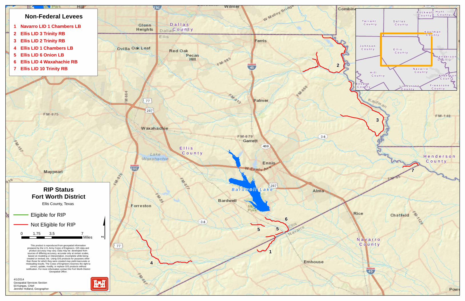
B a r d w e l l L a k e
J o e P o o l L a k e
E l l i s C o u n t y
N a v a r r o C o u n t y
K a u f m a n C o u n t y
D a l l a s C o u n t y
H i l l C o u n t y
H e n d e r s o n C o u n t y
5
4
5
3
6
7
1
2
0 3.5 71.75Miles
Eligible for RIP
Not Eligible for RIP
Geospatial Services SectionEli Kangas, ChiefJennifer Holland, Geographer
4/1/2014
RIP StatusFort Worth District
Ellis County, Texas
1 Navarro LID 1 Chambers LB
Non-Federal Levees
2 Ellis LID 3 Trinity RB3 Ellis LID 2 Trinity RB4 Ellis LID 1 Chambers LB5 Ellis LID 6 Onion LB6 Ellis LID 4 Waxahachie RB7 Ellis LID 10 Trinity RB
This product is reproduced from geospatial informationprepared by the U.S. Army Corps of Engineers. GIS data and
product accuracy may vary. Data may be: developed fromsources of differing accuracy, accurate only at certain scales,based on modeling or interpretation, incomplete while being
created or revised, etc. Using GIS products for purposes otherthan those for which they were created may yield inaccurate ormisleading results. The Corps of Engineers reserves the right to
correct, update, modify, or replace GIS products withoutnotification. For more information contact the Fort Worth District
Geospatial Office.
N a v a r r o C o u n t yH i l l
C o u n t y
E l l i s C o u n t y
D a l l a s C o u n t y
K a u f m a n C o u n t y
T a r r a n t C o u n t y
J o h n s o n C o u n t y
F r e e s t o n e C o u n t y
H u n t C o u n t y
H e n d e r s o n C o u n t y
R o c k w a l l C o u n t y
B o s q u e C o u n t y L i m e s t o n e
C o u n t y
A n d e r s o n C o u n t y

F r a n k l i n C o u n t y
R e d R i v e r C o u n t y
H o p k i n s C o u n t y
L a m a r C o u n t y
D e l t a C o u n t y
Sulphur River
Sulphur River
CC oo bb bb JJ oo nn ee ss CC rr eeeekk
MM uu ss tt aa nn gg CCrree ee kk
SSoo uu tt hh SSuu ll pp hh uu rr RR ii vv ee rr
1
1
0 0.6 1.20.3Miles
Eligible for RIP
Not Eligible for RIP
Geospatial Services SectionEli Kangas, ChiefJennifer Holland, Geographer
4/1/2014
RIP StatusFort Worth District
Franklin County, Texas
1 Franklin LID 1 Sulphur RB
Non-Federal Levees
This product is reproduced from geospatial informationprepared by the U.S. Army Corps of Engineers. GIS data and
product accuracy may vary. Data may be: developed fromsources of differing accuracy, accurate only at certain scales,based on modeling or interpretation, incomplete while being
created or revised, etc. Using GIS products for purposes otherthan those for which they were created may yield inaccurate ormisleading results. The Corps of Engineers reserves the right to
correct, update, modify, or replace GIS products withoutnotification. For more information contact the Fort Worth District
Geospatial Office.
F r a n k l i n C o u n t y
R e d R i v e r C o u n t y
H o p k i n s C o u n t y
L a m a r C o u n t y
D e l t a C o u n t y

G u a d a l u p e C o u n t y
C o m a l C o u n t y
B e x a r C o u n t y
1
0 1.5 30.75Miles
Eligible for RIP
Not Eligible for RIP
Geospatial Services SectionEli Kangas, ChiefJennifer Holland, Geographer
4/1/2014
RIP StatusFort Worth District
Guadalupe County, Texas
1 Walnut Branch Channel
Federal Channel
This product is reproduced from geospatial informationprepared by the U.S. Army Corps of Engineers. GIS data and
product accuracy may vary. Data may be: developed fromsources of differing accuracy, accurate only at certain scales,based on modeling or interpretation, incomplete while being
created or revised, etc. Using GIS products for purposes otherthan those for which they were created may yield inaccurate ormisleading results. The Corps of Engineers reserves the right to
correct, update, modify, or replace GIS products withoutnotification. For more information contact the Fort Worth District
Geospatial Office.
G u a d a l u p e C o u n t y
C o m a l C o u n t y
B e x a r C o u n t y
G o n z a l e s C o u n t y
C a l d w e l l C o u n t y
W i l s o n C o u n t y
H a y s C o u n t y

N a v a r r o C o u n t y
H e n d e r s o n C o u n t y
E l l i s C o u n t y
K a u f m a n C o u n t y
A n d e r s o n C o u n t y
V a n Z a n d t C o u n t y
F r e e s t o n e C o u n t y
1
2
0 3 61.5Miles
Eligible for RIP
Not Eligible for RIP
Geospatial Services SectionEli Kangas, ChiefJennifer Holland, Geographer
4/1/2014
RIP StatusFort Worth District
Henderson County, Texas
1 Henderson LID 1 Trinity LB
Non-Federal Levees
This product is reproduced from geospatial informationprepared by the U.S. Army Corps of Engineers. GIS data and
product accuracy may vary. Data may be: developed fromsources of differing accuracy, accurate only at certain scales,based on modeling or interpretation, incomplete while being
created or revised, etc. Using GIS products for purposes otherthan those for which they were created may yield inaccurate ormisleading results. The Corps of Engineers reserves the right to
correct, update, modify, or replace GIS products withoutnotification. For more information contact the Fort Worth District
Geospatial Office.
2 Henderson LID 3 Trinity LB
N a v a r r o C o u n t y
E l l i s C o u n t y
H e n d e r s o n C o u n t y
K a u f m a n C o u n t y
V a n Z a n d t C o u n t y
F r e e s t o n e C o u n t y
A n d e r s o n C o u n t y
D a l l a s C o u n t y
L i m e s t o n e C o u n t y
H i l l C o u n t y

C o o p e r D a m / J i m C h a p m a n L a k e
H o p k i n s C o u n t y
D e l t a C o u n t y
SS oo uu tt hh SS uull pphh uurr RR iivveerr
BBiigg CCrree eekkBB rr uu ss hh yy CCrree ee kk
MM oo rr gg aa nn CC
rr eeee kk
VV aa ddee nn
CCrr ee
ee kk
CCrroossssttiimmbbeerr CCrreeeekk
BBooyydd BBrraa nn cchh
WW
oollff CCrreeeekk
DD oo cc tt oorrss CCrreeeekk
EEvv aa nnss BBrraanncchh
LL aakkee CCrreeeekk
LL ooggssttoonn BBrraanncchh
LLiittttll ee CCaanneeyy CCrreeeekk
WW oo ll ff pp ee nn CC rr eeee kk
MMooo orree CCrreeeekk
MM
ccGGuuyyeerr BBrraanncchh
GGrreeeennbbrriieerr BBrraanncchh
NNoo rr tthh CCaann ee yy CC rr ee eekk
RReedd BBrraanncchh
PP oo ss tt OOaa kk
CCrr ee
ee kk
EEaasstt FFoorrkk BBiigg CCrreeeekk
FFiinnll ee yy BB rraa nn cc hh
CCaannnnoonn CCrreeeekk
SSoouutthh SSuu llpp hhuu rr RRiivveerr
1
2
0 1 20.5Miles
Eligible for RIP
Not Eligible for RIP
Geospatial Services SectionEli Kangas, ChiefJennifer Holland, Geographer
4/1/2014
RIP StatusFort Worth District
Hopkins County, Texas
1 Hopkins LID 1 South Sulphur RB
Non-Federal Levees
This product is reproduced from geospatial informationprepared by the U.S. Army Corps of Engineers. GIS data and
product accuracy may vary. Data may be: developed fromsources of differing accuracy, accurate only at certain scales,based on modeling or interpretation, incomplete while being
created or revised, etc. Using GIS products for purposes otherthan those for which they were created may yield inaccurate ormisleading results. The Corps of Engineers reserves the right to
correct, update, modify, or replace GIS products withoutnotification. For more information contact the Fort Worth District
Geospatial Office.
H o p k i n s C o u n t y
D e l t a C o u n t y
L a m a r C o u n t y

H o u s t o n C o u n t y
L e o n C o u n t y
M a d i s o n C o u n t y
T r i n i t y C o u n t y
F r e e s t o n e C o u n t y
A n d e r s o n C o u n t y
W a l k e r C o u n t y
3
1
2
0 4 82Miles
Eligible for RIP
Not Eligible for RIP
Geospatial Services SectionEli Kangas, ChiefJennifer Holland, Geographer
4/1/2014
RIP StatusFort Worth District
Houston County, Texas
1 Anderson LID 2 Trinity LB
Non-Federal Levees
This product is reproduced from geospatial informationprepared by the U.S. Army Corps of Engineers. GIS data and
product accuracy may vary. Data may be: developed fromsources of differing accuracy, accurate only at certain scales,based on modeling or interpretation, incomplete while being
created or revised, etc. Using GIS products for purposes otherthan those for which they were created may yield inaccurate ormisleading results. The Corps of Engineers reserves the right to
correct, update, modify, or replace GIS products withoutnotification. For more information contact the Fort Worth District
Geospatial Office.
2 Houston LID 2 Trinity LB3 Houston LID 1 Trinity LB
H o u s t o n C o u n t y
L e o n C o u n t y
A n d e r s o n C o u n t y
T r i n i t y C o u n t y
F r e e s t o n e C o u n t y
C h e r o k e e C o u n t y
W a l k e r C o u n t y
M a d i s o n C o u n t y
P o l k C o u n t y
B r a z o s C o u n t y
G r i m e s C o u n t y
R o b e r t s o n C o u n t y
L i m e s t o n e C o u n t y
N a v a r r o C o u n t y
S a n J a c i n t o C o u n t y
A n g e l i n a C o u n t y
R u s k C o u n t y

H o w a r d C o u n t y
M a r t i n C o u n t y 1
0 2 41Miles
Eligible for RIP
Not Eligible for RIP
Geospatial Services SectionEli Kangas, ChiefJennifer Holland, Geographer
4/1/2014
RIP StatusFort Worth District
Howard County, Texas
1 Beals Creek Channel
Federal Channel
This product is reproduced from geospatial informationprepared by the U.S. Army Corps of Engineers. GIS data and
product accuracy may vary. Data may be: developed fromsources of differing accuracy, accurate only at certain scales,based on modeling or interpretation, incomplete while being
created or revised, etc. Using GIS products for purposes otherthan those for which they were created may yield inaccurate ormisleading results. The Corps of Engineers reserves the right to
correct, update, modify, or replace GIS products withoutnotification. For more information contact the Fort Worth District
Geospatial Office.
H o w a r d C o u n t y
M a r t i n C o u n t y
G l a s s c o c k C o u n t y
M i t c h e l l C o u n t y
B o r d e n C o u n t y
S t e r l i n g C o u n t y
M i d l a n d C o u n t y
D a w s o n C o u n t y
S c u r r y C o u n t y

H u n t C o u n t y
C o l l i n C o u n t y
1
0 2 41Miles
Eligible for RIP
Not Eligible for RIP
Geospatial Services SectionEli Kangas, ChiefJennifer Holland, Geographer
4/1/2014
RIP StatusFort Worth District
Hunt County, Texas
1 Long Branch Creek Channel
Federal Channel
This product is reproduced from geospatial informationprepared by the U.S. Army Corps of Engineers. GIS data and
product accuracy may vary. Data may be: developed fromsources of differing accuracy, accurate only at certain scales,based on modeling or interpretation, incomplete while being
created or revised, etc. Using GIS products for purposes otherthan those for which they were created may yield inaccurate ormisleading results. The Corps of Engineers reserves the right to
correct, update, modify, or replace GIS products withoutnotification. For more information contact the Fort Worth District
Geospatial Office.
H u n t C o u n t y
C o l l i n C o u n t y
F a n n i n C o u n t y
H o p k i n s C o u n t y
R a i n s C o u n t y
D e l t a C o u n t y
R o c k w a l l C o u n t y
K a u f m a n C o u n t y
G r a y s o n C o u n t y
V a n Z a n d t C o u n t y
L a m a r C o u n t y

B a r d w e l l L a k e
K a u f m a n C o u n t y
D a l l a s C o u n t y
E l l i s C o u n t y
H e n d e r s o n C o u n t y
R o c k w a l l C o u n t y
N a v a r r o C o u n t y
8
3
5
4
67
12
0 3.5 71.75Miles
Eligible for RIP
Not Eligible for RIP
Geospatial Services SectionEli Kangas, ChiefJennifer Holland, Geographer
4/1/2014
RIP StatusFort Worth District
Kaufman County, Texas
11 East Fork Floodway ChannelFederal Channel
This product is reproduced from geospatial informationprepared by the U.S. Army Corps of Engineers. GIS data and
product accuracy may vary. Data may be: developed fromsources of differing accuracy, accurate only at certain scales,based on modeling or interpretation, incomplete while being
created or revised, etc. Using GIS products for purposes otherthan those for which they were created may yield inaccurate ormisleading results. The Corps of Engineers reserves the right to
correct, update, modify, or replace GIS products withoutnotification. For more information contact the Fort Worth District
Geospatial Office.
E l l i s C o u n t y
D a l l a s C o u n t y
N a v a r r o C o u n t y
K a u f m a n C o u n t y
H u n t C o u n t y
H i l l C o u n t y
T a r r a n t C o u n t y
C o l l i n C o u n t y
V a n Z a n d t C o u n t y
H e n d e r s o n C o u n t y
D e n t o n C o u n t y
J o h n s o nC o u n t y
R a i n s C o u n t y
R o c k w a l l C o u n t y
H o p k i n s C o u n t y
A n d e r s o n C o u n t y
Federal Levee1 Kaufman 5 East, East Fork Trinity LB2 Kaufman 5 West, East Fork Trinity RB3 Kaufman MUD 1, East Fork Trinity LB
Non-Federal Levee4 Bois D’Arc Levee Trinity LB5 Kaufman LID 1 East Fork Trinity LB6 Kaufman LID 10 East Fork Trinity RB7 Kaufman LID 13 East Fork Trinity LB8 Kaufman LID 15 East Fork Trinity LB9 Kaufman LID 6 East Fork Trinity LB10 Kaufman LID 8 East Fork Trinity RB
9
10
11

K n o x C o u n t y
H a s k e l l C o u n t y
B a y l o r C o u n t y
T h r o c k m o r t o n C o u n t y
1
0 1.5 30.75Miles
Eligible for RIP
Not Eligible for RIP
Geospatial Services SectionEli Kangas, ChiefJennifer Holland, Geographer
4/1/2014
RIP StatusFort Worth District
Knox County, Texas
1 Munday Channel
Federal Channel
This product is reproduced from geospatial informationprepared by the U.S. Army Corps of Engineers. GIS data and
product accuracy may vary. Data may be: developed fromsources of differing accuracy, accurate only at certain scales,based on modeling or interpretation, incomplete while being
created or revised, etc. Using GIS products for purposes otherthan those for which they were created may yield inaccurate ormisleading results. The Corps of Engineers reserves the right to
correct, update, modify, or replace GIS products withoutnotification. For more information contact the Fort Worth District
Geospatial Office.
K n o x C o u n t y
H a s k e l l C o u n t y
B a y l o r C o u n t y
T h r o c k m o r t o n C o u n t y
K i n g C o u n t y
S t o n e w a l l C o u n t y
F o a r d C o u n t y

C o o p e r D a m / J i m C h a p m a n L a k e
L a m a r C o u n t y
H o p k i n s C o u n t y
D e l t a C o u n t y
R e d R i v e r C o u n t y
F r a n k l i n C o u n t y
1
0 2 41Miles
Eligible for RIP
Not Eligible for RIP
Geospatial Services SectionEli Kangas, ChiefJennifer Holland, Geographer
4/1/2014
RIP StatusFort Worth District
Lamar County, Texas
1 Lamar LID 1 North Sulphur RB
Non-Federal Levee
This product is reproduced from geospatial informationprepared by the U.S. Army Corps of Engineers. GIS data and
product accuracy may vary. Data may be: developed fromsources of differing accuracy, accurate only at certain scales,based on modeling or interpretation, incomplete while being
created or revised, etc. Using GIS products for purposes otherthan those for which they were created may yield inaccurate ormisleading results. The Corps of Engineers reserves the right to
correct, update, modify, or replace GIS products withoutnotification. For more information contact the Fort Worth District
Geospatial Office.
L a m a r C o u n t y
H o p k i n s C o u n t y
R e d R i v e r C o u n t y
D e l t a C o u n t y
F r a n k l i n C o u n t y
T i t u s C o u n t y
F a n n i n C o u n t y
H u n t C o u n t y
C a m p C o u n t y

M c L e n n a n C o u n t y
Flat CreekFlat Creek
SS hh aa ww CC rr ee ee kk
CC oo tt tt oo nn ww oo oo dd CCrr ee ee kk
TTee hh
uu aacc aa nn aa CC rr eeeekk
WWaa cc oo CC rr ee ee kk
TT rraadd iinngg hh oo uu ss ee CC rr eeee kk
1
0 0.5 10.25Miles
Eligible for RIP
Not Eligible for RIP
Geospatial Services SectionEli Kangas, ChiefJennifer Holland, Geographer
4/1/2014
RIP StatusFort Worth District
McLennan County, Texas
1 Brazos River WastewaterTreatment Plant Bank Protection
Bank Protection
This product is reproduced from geospatial informationprepared by the U.S. Army Corps of Engineers. GIS data and
product accuracy may vary. Data may be: developed fromsources of differing accuracy, accurate only at certain scales,based on modeling or interpretation, incomplete while being
created or revised, etc. Using GIS products for purposes otherthan those for which they were created may yield inaccurate ormisleading results. The Corps of Engineers reserves the right to
correct, update, modify, or replace GIS products withoutnotification. For more information contact the Fort Worth District
Geospatial Office.
M c L e n n a n C o u n t y
F a l l s C o u n t y

G r a n g e r L a k e
M i l a m C o u n t y
B e l l C o u n t y
W i l l i a m s o n C o u n t y
B u r l e s o n C o u n t y
1
0 2.5 51.25Miles
Eligible for RIP
Not Eligible for RIP
Geospatial Services SectionEli Kangas, ChiefJennifer Holland, Geographer
4/1/2014
RIP StatusFort Worth District
Milam County, Texas
1 Hefley LID Little River RB
Non-Federal Levee
This product is reproduced from geospatial informationprepared by the U.S. Army Corps of Engineers. GIS data and
product accuracy may vary. Data may be: developed fromsources of differing accuracy, accurate only at certain scales,based on modeling or interpretation, incomplete while being
created or revised, etc. Using GIS products for purposes otherthan those for which they were created may yield inaccurate ormisleading results. The Corps of Engineers reserves the right to
correct, update, modify, or replace GIS products withoutnotification. For more information contact the Fort Worth District
Geospatial Office.
M i l a m C o u n t y
B e l l C o u n t y
W i l l i a m s o n C o u n t y
B u r l e s o n C o u n t y
L e e C o u n t y
R o b e r t s o n C o u n t y
F a l l s C o u n t y
T r a v i s C o u n t y B a s t r o p
C o u n t y
B r a z o s C o u n t y
W a s h i n g t o n C o u n t y
C o r y e l l C o u n t y

B a r d w e l l L a k e
N a v a r r o C o u n t y
H e n d e r s o n C o u n t y
E l l i s C o u n t y
K a u f m a n C o u n t y
F r e e s t o n e C o u n t y
A n d e r s o n C o u n t y
V a n Z a n d t C o u n t y
5
10
3
8
1
6
7
4
2
9
0 3 61.5Miles
Eligible for RIP
Not Eligible for RIP
Geospatial Services SectionEli Kangas, ChiefJennifer Holland, Geographer
4/1/2014
RIP StatusFort Worth District
Navarro County, Texas
1 Henderson LID 3 Trinity LB
Non-Federal Levee
This product is reproduced from geospatial informationprepared by the U.S. Army Corps of Engineers. GIS data and
product accuracy may vary. Data may be: developed fromsources of differing accuracy, accurate only at certain scales,based on modeling or interpretation, incomplete while being
created or revised, etc. Using GIS products for purposes otherthan those for which they were created may yield inaccurate ormisleading results. The Corps of Engineers reserves the right to
correct, update, modify, or replace GIS products withoutnotification. For more information contact the Fort Worth District
Geospatial Office.
2 Lewis Simpson Trinity RB3 Navarro LID 1 Chambers LB4 Navarro LID 10 Chambers LB5 Navarro LID 10 Chambers RB6 Navarro LID 11 Chambers LB7 Navarro LID 3 Trinity RB8 Navarro LID 4 Chambers RB9 Navarro LID 6 Chambers RB10 Pettigrew Levee Trinity RB
N a v a r r o C o u n t y
E l l i s C o u n t y
K a u f m a n C o u n t y
H e n d e r s o n C o u n t y
F r e e s t o n e C o u n t y
V a n Z a n d t C o u n t y
A n d e r s o n C o u n t y
D a l l a s C o u n t y
H i l l C o u n t y
L i m e s t o n e C o u n t y L e o n
C o u n t y
R a i n s C o u n t y
R e d R i v e r C o u n t y
F r a n k l i n C o u n t y
L a m a r C o u n t y
H o p k i n s C o u n t y
D e l t a C o u n t y
Sulphur River
Sulphur River
MMuusstt aanngg CC rreeeekk
LLi it tt tl lee SSaannddyy CCrreeeekk
WW hh ii tt ee OO aa kk BB rr aann cc hh
SS oouu tt hh SS uu ll pp hh uu rr RR ii vv ee rr
SSoo uu tt hh SSuu ll pp hh uu rr RR ii vv ee rr
1
0 0.6 1.20.3Miles
Eligible for RIP
Not Eligible for RIP
Geospatial Services SectionEli Kangas, ChiefJennifer Holland, Geographer
4/1/2014
RIP StatusFort Worth District
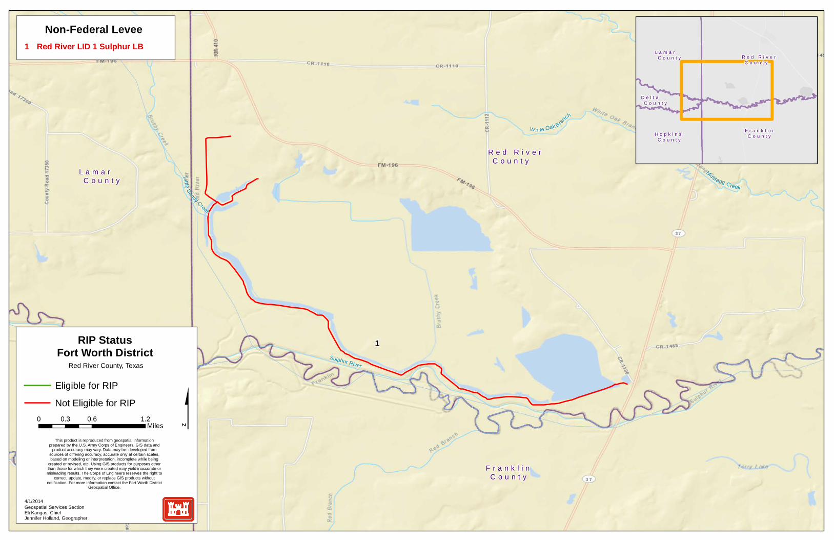
Red River County, Texas
1 Red River LID 1 Sulphur LB
Non-Federal Levee
This product is reproduced from geospatial informationprepared by the U.S. Army Corps of Engineers. GIS data and
product accuracy may vary. Data may be: developed fromsources of differing accuracy, accurate only at certain scales,based on modeling or interpretation, incomplete while being
created or revised, etc. Using GIS products for purposes otherthan those for which they were created may yield inaccurate ormisleading results. The Corps of Engineers reserves the right to
correct, update, modify, or replace GIS products withoutnotification. For more information contact the Fort Worth District
Geospatial Office.
R e d R i v e r C o u n t y
F r a n k l i n C o u n t y
L a m a r C o u n t y
H o p k i n s C o u n t y
D e l t a C o u n t y
B e n b r o o k R e s e r v o i r
J o e P o o l L a k e
T a r r a n t C o u n t y
P a r k e r C o u n t y
5103
8
1
6
7
4
2
9
1 Big Fossil Creek Levee Big Fossil LBFederal Levee
T a r r a n t C o u n t y
P a r k e r C o u n t y
D e n t o n C o u n t y
D a l l a s C o u n t y
J o h n s o n C o u n t y
W i s e C o u n t y
E l l i s C o u n t y
H o o d C o u n t y
C o l l i n C o u n t y
0 2 41Miles
Eligible for RIP
Not Eligible for RIP
Geospatial Services SectionEli Kangas, ChiefJennifer Holland, Geographer
4/1/2014
RIP StatusFort Worth District
Tarrant County, Texas
This product is reproduced from geospatial informationprepared by the U.S. Army Corps of Engineers. GIS data and
product accuracy may vary. Data may be: developed fromsources of differing accuracy, accurate only at certain scales,based on modeling or interpretation, incomplete while being
created or revised, etc. Using GIS products for purposes otherthan those for which they were created may yield inaccurate ormisleading results. The Corps of Engineers reserves the right to
correct, update, modify, or replace GIS products withoutnotification. For more information contact the Fort Worth District
Geospatial Office.
Non-Federal Levee
Federal Channel
Bank Protection
2 Brookside Levee West Fork LB3 Carswell Levee West Fork LB4 Clear Fork Levee Loop Clear Fork LB5 Crestwood Levee West Fork RB6 North Main Levee Loop West Fork LB7 Overton Levee Clear Fork RB8 Sump #6 Levee West Fork LB9 Watermelon Levee Clear Fork RB10 West Fork Levee Loop West Fork RB11 White Settlement Levee West Fork RB
12 Waterworks Levee Clear Fork RB
13 Big Fossil Floodway Channel
26 Arlington Landfill Bank Protection27 River Oaks Bank Protection
18 Johnson Creek Channel
25 Park Row Bridge Bank Protection
22 Sulphur Branch Channel21 Singing Hills Channel20 Rush Creek Channel19 Lorean Branch Channel
15 Fort Worth Floodway West Fork Above Clear Fork Channel
14 Calloway Branch Channel
11
12
13
14
15
16 Fort Worth Floodway West Fork Below Clear Fork Channel
16
17
17 Fort Worth Floodway Clear Fork Channel
18
19
20
21
22
24 Marys Creek Bank Protection23 Indian Creek Bank Protection
27
26
25
24
23

T a y l o r C o u n t y
J o n e s C o u n t y
Elm CreekElm Creek
CC ee dd aa rr CC rr ee ee kk
RR
aaiinnyy CCrreeeekk
II nn dd ii aa nn CCrr ee ee kk
CCaa
tt CC
ll aaww
CCrr ee ee kk
L Li it tt tl le e EEl lmm
CCrr eeeekk
BBuu cckk CC rr ee ee kk
LLyyttllee CCrreeeekk
1
0 0.8 1.60.4Miles
Eligible for RIP
Not Eligible for RIP
Geospatial Services SectionEli Kangas, ChiefJennifer Holland, Geographer
4/1/2014
RIP StatusFort Worth District
Taylor County, Texas
1 Cat Claw Creek Channel
Federal Channel
This product is reproduced from geospatial informationprepared by the U.S. Army Corps of Engineers. GIS data and
product accuracy may vary. Data may be: developed fromsources of differing accuracy, accurate only at certain scales,based on modeling or interpretation, incomplete while being
created or revised, etc. Using GIS products for purposes otherthan those for which they were created may yield inaccurate ormisleading results. The Corps of Engineers reserves the right to
correct, update, modify, or replace GIS products withoutnotification. For more information contact the Fort Worth District
Geospatial Office.
T a y l o r C o u n t y
J o n e s C o u n t y
C a l l a h a n C o u n t y
S h a c k e l f o r d C o u n t y
T r a v i s C o u n t y
B a s t r o p C o u n t y
H a y s C o u n t y
1
0 2 41Miles
Eligible for RIP
Not Eligible for RIP
Geospatial Services SectionEli Kangas, ChiefJennifer Holland, Geographer
4/1/2014
RIP StatusFort Worth District
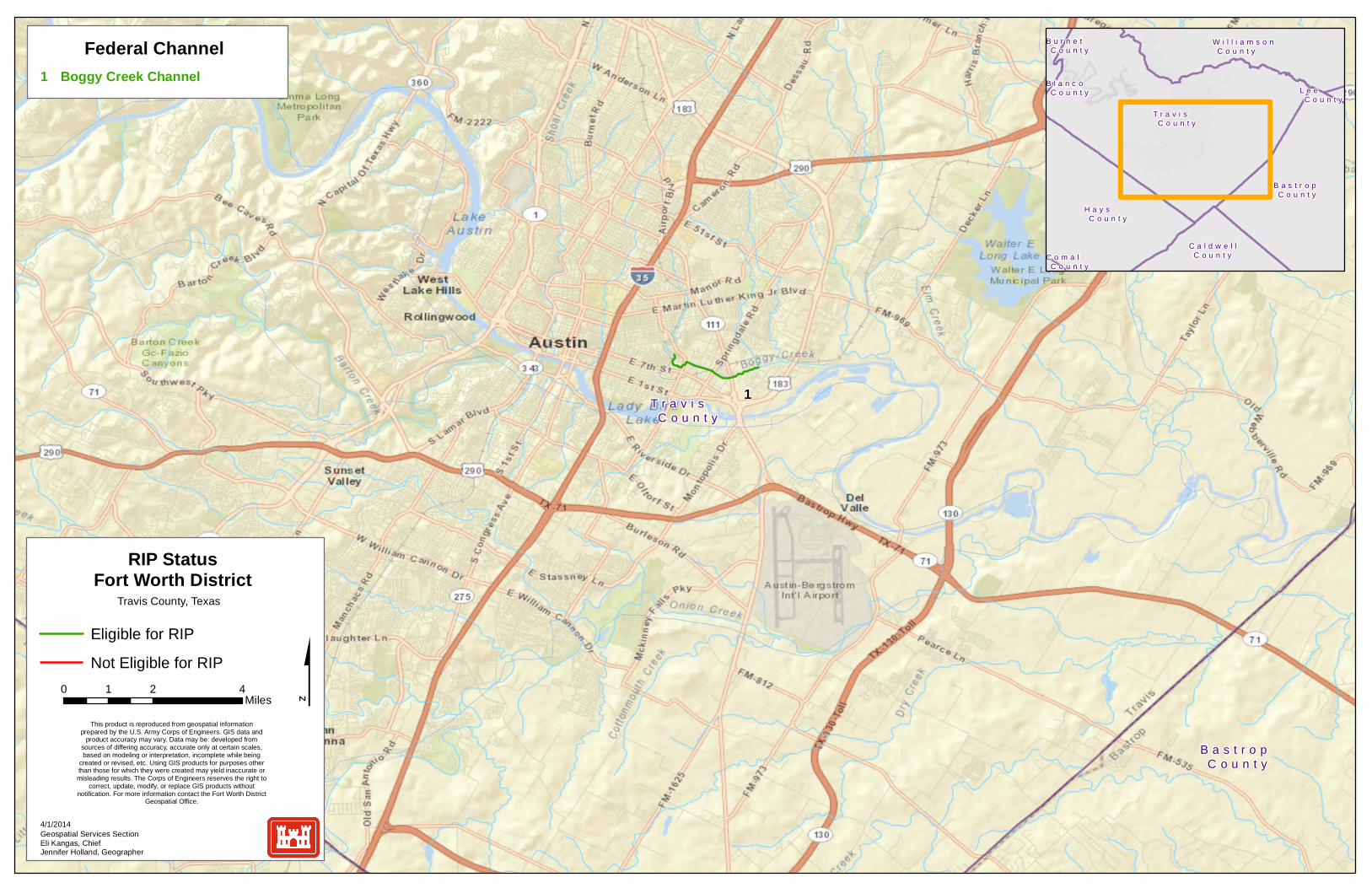
Travis County, Texas
1 Boggy Creek Channel
Federal Channel
This product is reproduced from geospatial informationprepared by the U.S. Army Corps of Engineers. GIS data and
product accuracy may vary. Data may be: developed fromsources of differing accuracy, accurate only at certain scales,based on modeling or interpretation, incomplete while being
created or revised, etc. Using GIS products for purposes otherthan those for which they were created may yield inaccurate ormisleading results. The Corps of Engineers reserves the right to
correct, update, modify, or replace GIS products withoutnotification. For more information contact the Fort Worth District
Geospatial Office.
T r a v i s C o u n t y
B a s t r o p C o u n t y
H a y s C o u n t y
W i l l i a m s o n C o u n t y
C a l d w e l l C o u n t y
B u r n e t C o u n t y
L e e C o u n t y
C o m a l C o u n t y
B l a n c o C o u n t y

W e b b C o u n t y
Z a p a t a C o u n t y
1
0 4.5 92.25Miles
Eligible for RIP
Not Eligible for RIP
Geospatial Services SectionEli Kangas, ChiefJennifer Holland, Geographer
4/1/2014
RIP StatusFort Worth District
Webb County, Texas
1 Zacate Creek Channel
Federal Channel
This product is reproduced from geospatial informationprepared by the U.S. Army Corps of Engineers. GIS data and
product accuracy may vary. Data may be: developed fromsources of differing accuracy, accurate only at certain scales,based on modeling or interpretation, incomplete while being
created or revised, etc. Using GIS products for purposes otherthan those for which they were created may yield inaccurate ormisleading results. The Corps of Engineers reserves the right to
correct, update, modify, or replace GIS products withoutnotification. For more information contact the Fort Worth District
Geospatial Office.
W e b b C o u n t y D u v a l
C o u n t y
Z a p a t a C o u n t y
J i m H o g g C o u n t y
L a S a l l e C o u n t y
D i m m i t C o u n t y M c M u l l e n
C o u n t y
M a v e r i c k C o u n t y
S t a r r C o u n t y
B r o o k s C o u n t y