2007 nascio award submission · 2010 nascio award submission . ... caas gis web site, state of...
TRANSCRIPT
2010 NASCIO Award Submission Category:
Digital Government: Government to Government
Project: CAAS GIS Web Site,
State of Tennessee, Comptroller of the Treasury, Division of Property Assessments and Office of Local Government
State of Tennessee, Department of Finance and Administration, Office for Information Resources
Executive Summary
In 2008, the State of Tennessee, Comptroller of the Treasury and the Department of Finance and Administration (F&A) unveiled a statewide Geographic Information System (GIS) real property web application designed to serve multiple levels of government. This application leverages data from the Comptroller of the Treasury, Division of Property Assessment’s “Computer Assisted Appraisal System” (CAAS) and GIS parcel information developed through the Tennessee Base Mapping Program managed by F&A, Office for Information Resources, GIS Services group (OIR-GIS). This project was part of a larger initiative to develop standard GIS data products to support property assessments, economic development, transportation planning, public safety, and environmental management at all levels of government. Leveraging State IT standards, this enterprise approach towards managing a statewide parcel GIS system allowed the State to provide GIS data and services to a variety of government entities. Based on an existing standard real property database, where 90 out of the 95 counties used the State’s CAAS database, the Comptroller’s Office developed a public facing web application to access real property data. The CAAS web application was rolled out in 2001 and was immediately a success. The federal, state, and local government had an easy method to search and find information about real property throughout the State. Although the site received a large amount of traffic, the initial application lacked the ability to link to any of the GIS data produced through the Tennessee Base Mapping Program (TNBMP). At the conclusion of the TNBMP data production in 2007, the goal for the CAAS web site was to enhance it and included links to the digital parcel layer and other GIS data sets including ortho imagery, streets, administrative boundaries and others. By including these GIS layers, the new CAAS-GIS web site evolved into the primary source for government access to TNBMP GIS data. It also continued in its goal to provide open government and allow access to these State resources, maximizing government engagement and interaction with the CAAS GIS application. The ability of multiple government organizations to access real property assessment information and maps has been transformed. Prior to this on-line web application, the only method to obtain maps or assessment information was to visit the county property assessor’s office at the county courthouse. Employees in the assessor’s office would often have to make copies of maps and look up assessment information on behalf of government consumers of real property information, taking time away from other office responsibilities. With the implementation of the new CAAS-GIS application, government employees can go to one location and not only find assessment information but also view a map of the location, eliminating or reducing the ‘foot traffic’ and phone calls to state and county assessment officials.
Description of the Business Problem and Solution The Problem – Transparency in Real Property and GIS databases The Comptroller of the Treasury, Division of Property Assessment has fiduciary responsibilities to maintain a statewide real property database. Serving as the state steward for county property assessment information, the Division of Property Assessment built a statewide mainframe real property database in the 1970’s. The Division of Property Assessments provides the county property assessor with the ability to update this statewide real property database. Over the years, a growing problem existed. The database was not accessible to other government agencies. Without an on-line tool to access this database, federal, state, and local governments would have to call the county property assessor or State officials, or travel to the county courthouse to gain access to information regarding their property assessment or related information. This resulted in government employees making several visits to the courthouse or time consuming phone calls into State and county officials, creating an inefficient approach to managing State assets and information technology. In order to make this database more transparent and improve real property data accessibility, Tennessee State and local government officials decided to create a web-based application designed to view, query, and verify their property assessment information and eventually provide links to digital maps that shows the parcel boundaries and related base map information. The Solution – Web based Geographic Information Systems and the Tennessee Base Mapping Program The solution was designed to leverage OIR-GIS staff and the enterprise GIS infrastructure branded as the “Tennessee Map” (TNMap), along with the GIS data products produced through the Tennessee Base Mapping Program to GIS-enable the statewide CAAS web application. The award winning Tennessee Base Mapping Program was designed to create a foundation or framework of basic GIS data products that could be used to support a wide range of applications at all levels of government. With over 250 local government partners, the State and its contractors were able to create digital parcels, ortho photography and other GIS layers over an eight year period, concluding in July 2007. Once the entire set of paper parcel maps were converted to a GIS format through the TNBMP, one of the first objectives in creating the GIS application was for the Division of Property Assessments to provide the digital parcel data to OIR GIS. Leveraging the TNMap enterprise GIS infrastructure, based on ESRI’s ArcIMS and ArcGIS Server technology, web map services were created. These GIS parcel map images were then linked to the CAAS web site through a unique parcel identification number. Once this link was established users could view the digital parcel data via a web browser and get
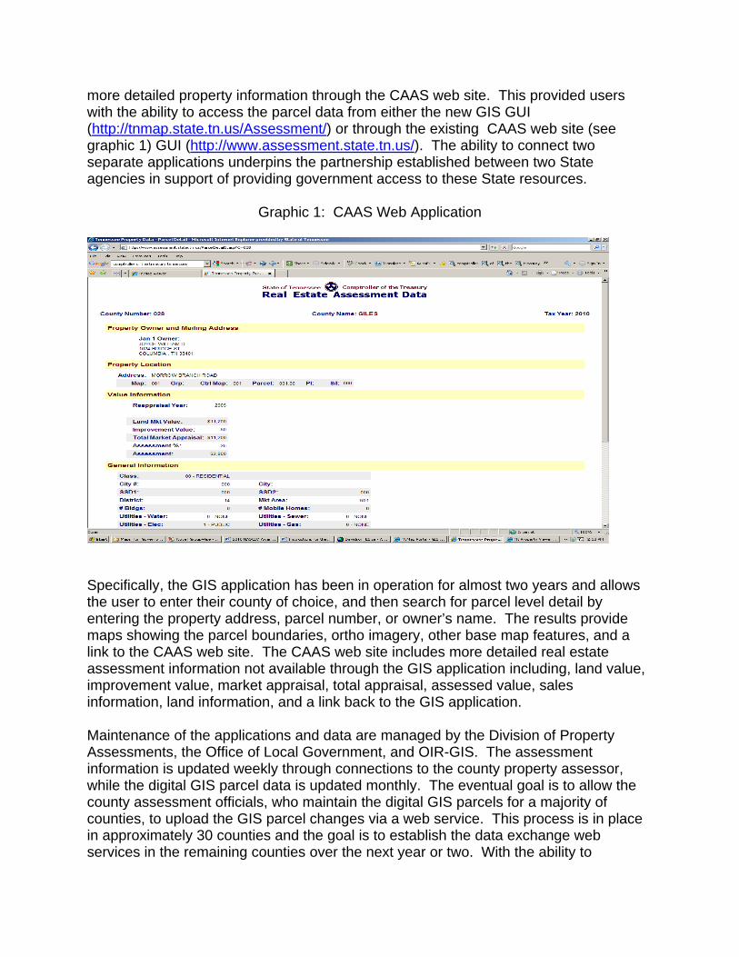
more detailed property information through the CAAS web site. This provided users with the ability to access the parcel data from either the new GIS GUI (http://tnmap.state.tn.us/Assessment/) or through the existing CAAS web site (see graphic 1) GUI (http://www.assessment.state.tn.us/). The ability to connect two separate applications underpins the partnership established between two State agencies in support of providing government access to these State resources.
Graphic 1: CAAS Web Application
Specifically, the GIS application has been in operation for almost two years and allows the user to enter their county of choice, and then search for parcel level detail by entering the property address, parcel number, or owner’s name. The results provide maps showing the parcel boundaries, ortho imagery, other base map features, and a link to the CAAS web site. The CAAS web site includes more detailed real estate assessment information not available through the GIS application including, land value, improvement value, market appraisal, total appraisal, assessed value, sales information, land information, and a link back to the GIS application. Maintenance of the applications and data are managed by the Division of Property Assessments, the Office of Local Government, and OIR-GIS. The assessment information is updated weekly through connections to the county property assessor, while the digital GIS parcel data is updated monthly. The eventual goal is to allow the county assessment officials, who maintain the digital GIS parcels for a majority of counties, to upload the GIS parcel changes via a web service. This process is in place in approximately 30 counties and the goal is to establish the data exchange web services in the remaining counties over the next year or two. With the ability to
consume updated GIS data through a web service, this will provide the web applications with the most current parcel information available and improve the services provided to other government agencies.
Significance to the improvement of the operation of government
The ability of multiple government organizations to access real property assessment information and maps has been transformed. Prior to this on-line web application, the only method to obtain maps or assessment information was to visit the county property assessor’s office at the county courthouse. Employees in the assessor’s office would often have to make copies of maps and look up assessment information on behalf of government consumers of real property information, taking time away from other office responsibilities. With the implementation of the new CAAS-GIS application, government employees can go to one location and not only find assessment information but also view a map of the location, eliminating or reducing the ‘foot traffic’ and phone calls to state and county assessment officials.
Overall, the CAAS-GIS application represents a paradigm shift for government officials. It transformed the function and workflow of State and local assessment officials from being overwhelmed with office visitors needing assessment information to conducting the routine business of operating an assessor’s office.
The improvements in the operation of government can also be measured in the amount of web traffic that the CAAS GIS web site has created. Following the rollout of the application in June 2008, OIR-GIS began tracking both the number of hits to the web site and the number of unique visitors based on IP addresses. Table 1 reflects these statistics for the month of April 2010.
Table 1: CAAS/GIS Web Traffic Statistics # of web site hits # of Unique Visitors
April 2010 April 2010 9,870,945 108,829
Benefits of the Project
One of the primary benefits of the project was the ability to develop a solution with minimal cost to both the Comptroller of the Treasury, the county property assessors, and other stakeholders. Using the TNMap GIS shared environment developed by OIR-GIS, the Division of Property Assessments did not have to procure dedicated hardware and software associated with implementing the solution. Instead, the Division of Property Assessments was able to cover the initial development costs (approximately $3,000) and the annual application hosting fee of $9,000. Through the annual hosting fee, the Division of Property Assessments has access to the entire set of GIS infrastructure and statewide GIS data layers associated with the TNMap.
The cost avoidance of using this shared GIS approach is significant. Without the TNMap GIS shared environment and the OIR-GIS staff to develop the application, the Comptroller of the Treasury, Division of Property Assessments would have spent approximately $113,500 on dedicated infrastructure (hardware and GIS software). This doesn’t include the $28 million dollars that would have to be spent to create the statewide GIS dataset (Tennessee Base Mapping Program). In addition, the Comptroller’s Office did not have to hire contract staff or dedicate other non OIR-GIS staff time towards developing the database and user interface. See Table 2.
Table 2: CAAS-GIS Application: Cost Avoidance Hardware Software GIS Data Web Server - $15K ESRI ArcIMS - $16K App Server - $15K SQL/Server - $50K DB Server – $15K MS 2003 Enterprise - $2,500
$28M
Ultimately, there were several government organizations that benefitted from this project.
1. The Tennessee County Property Assessors and other local government officials (register of deeds, planning department, election administrators, and codes officials) have an online service that allows them to search, view, and query this information at their fingertips, saving time and money.
2. Multiple departments within the Comptroller of the Treasury including, Division of Property Assessments, Office of State Assessed Properties, Tax Relief, and the Board of Equalization benefitted through their ability to assist counties with reappraisal programs, assist with tax relief efforts, aid in processing assessment appeals, and equalization of the property tax.
3. The Department of Economic and Community Development leveraged the application to aid in identifying potential properties for commercial development.
4. OIR-GIS benefited from this application by securing an additional consumer of the TNMap GIS data repository and being able to leverage the TNBMP data to support the business operations of the Comptroller of the Treasury and local government.
5. The US Census Bureau benefitted from the online tool through their Local Update of Census Addresses (LUCA) program. Having parcel level detail with digital maps provided them with an invaluable resource to update their address database and ultimately improve the overall response to the 2010 census.
6. FEMA and the Tennessee Emergency Management Agency (TEMA) were able to leverage the parcel GIS data to aid in disaster relief efforts to assess and calculate flood damage estimates as a result of widespread flooding in May 2010.
7. The Tennessee Valley Authority (TVA) uses the GIS parcel data to contact property owners that are impacted by proposed and existing transmission lines.
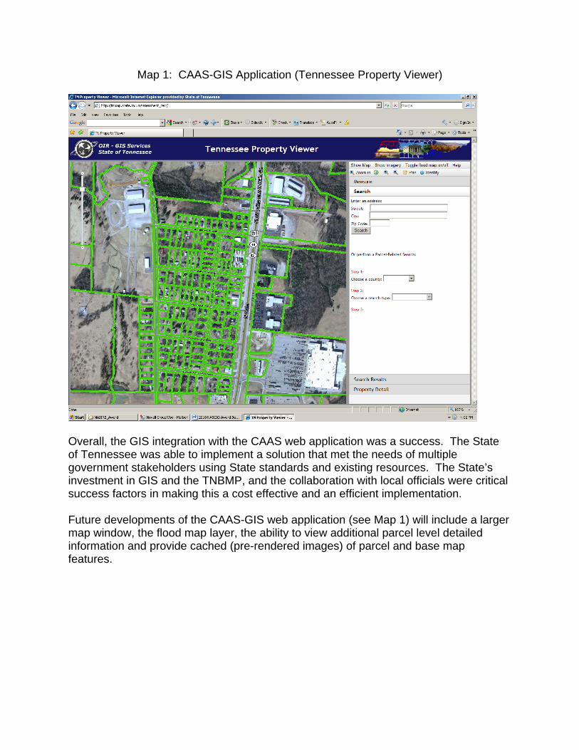
Map 1: CAAS-GIS Application (Tennessee Property Viewer)
Overall, the GIS integration with the CAAS web application was a success. The State of Tennessee was able to implement a solution that met the needs of multiple government stakeholders using State standards and existing resources. The State’s investment in GIS and the TNBMP, and the collaboration with local officials were critical success factors in making this a cost effective and an efficient implementation. Future developments of the CAAS-GIS web application (see Map 1) will include a larger map window, the flood map layer, the ability to view additional parcel level detailed information and provide cached (pre-rendered images) of parcel and base map features.