2 transpoclean edit9 - nasa · transportation is an important theme of exploration. vessel design,...
TRANSCRIPT
Exploration: Then and Now NASA and Jamestown Education Module EG-2006-09-25-LaRC Transportation Page 1 of 32
Grade Level: 6–8
Connections to Curriculum:
Science, Mathematics, and Geography
Teacher Preparation Time:
20 Minutes
Lesson Duration:
Six 50-Minute Classes
(See Pacing Chart for Options)
National Science Education Standards
Science as Inquiry
Science and Technology
National Council of Teachers ofMathematics Standards
Geometry
Measurement
Representations
National Geography Standards
The World in Spatial Terms
Places and Regions
Transportation Exploration: Then and Now
Essential QuestionHow do vessel design, navigation,and propulsion affect exploration?
Lesson Overview This lesson compares vessel design, navigation, and propulsion used by early Jamestown explorers to those used by the National Aeronautics and Space Administration (NASA). Students use maps and coordinate planes to demonstrate the Global Positioning System and to compare 17th-century mapmaking to modern technology. Students conduct experiments about sails and other propulsion systems.
Background Information Transportation is an important theme of exploration. Vessel design, navigation, and propulsion are all ideas related to transportation.
Vessel design, including its shape, size, and function, must be appropriate for the intended environment in order to be effective. A ship designed to sail the ocean would be too large to explore a narrow river channel, for example, just as an aircraft with wings is of little use in deep space, where there is no atmosphere to provide lift to the wings.
Navigation may be defined as the science and technology used to find the posi-tion and direct the course of vessels and aircraft. New inventions of the 16th century included navigational maps; the astrolabe, which allowed sailors to record latitude; and the magnetic compass, which allowed explorers to identify their direction at sea or on land. These innovations, although not very accurate, improved the ability of explorers to find their way to new places and return home again. The next great revolution in navigation occurred in the 20th century, when radio signals came into wide use. A modern-day explorer can turn on a GPS receiver and pinpoint a location to within a few meters.
The earliest kind of land propulsion was likely human muscle, pulling or pushing burdens on sticks or small wooden poles bound together. Progress in propulsion accelerated over the centuries with the invention of the wheel; the domestication
Exploration: Then and Now NASA and Jamestown Education Module EG-2006-09-25-LaRC Transportation Page 2 of 32
of the horse; the invention of the steam and combustion engines; the develop-ment of energy-dense fuels like oil and gasoline; and, in the 20th century, the development of chemical propellants for rockets. Nuclear energy is another means of propulsion, but its use is limited mostly to long-range naval vessels like submarines and aircraft carriers.
Because a spacecraft-carrying rocket must establish “escape velocity,” the veloc-ity required to overcome the strong pull of Earth’s gravity, rockets must use high-energy fuels. The most reliable way to launch humans and payloads into space depends on mixtures of highly reactive substances like oxygen, hydrogen, and kerosene. Although scientists are looking at ways to utilize innovative propulsion systems, such as scramjet technology, to reduce the dependence on chemically based propellants, no realistic rival to these mixtures currently exists.
Once spacecraft are launched into space and the exploration of faraway worlds becomes a reality, the capability to get there faster will become essential. New methods of propulsion, like solar sails, may be developed. Whatever systems prove practical will eventually permit people and supplies to travel farther than ever and at higher speeds than are currently possible.
Vessel design, navigation, and propulsion are integral components of transportation. The following activities are designed to increase students’ understanding of these aspects of exploration.
Instructional Objectives Students will:
• measure and compare the two-dimensional and three-dimensional space of the Godspeed, one of the ships that carried the Jamestown settlers, with that of the Orion spacecraft, the Crew Exploration Vehicle that will carry astronauts back to the Moon;
• use a compass to identify intersecting points to demonstrate how GPS works;
• use a coordinate plane to identify the latitude and longitude of a specific location on a map of the Moon;
• compare Landsat maps of the Chesapeake Bay with Captain John Smith’s maps of the same area;
• use a map or a magnetic compass to identify cardinal and intermediate directions on Captain John Smith’s map;
• construct, estimate surface area of, and test a model kite; • experiment and compare how three different surface areas affect a kite’s
flight; • design an experiment to test different propulsion systems; and • compare challenges faced by 17th- and 21st-century explorers.
Exploration: Then and Now NASA and Jamestown Education Module EG-2006-09-25-LaRC Transportation Page 3 of 32
Materials (Students will need journals and class charts in order to organize information throughout this lesson.)
Engage Per class:
• Meter sticks • 65 meters of masking tape (if activity is done indoors or on a blacktop
surface) or string and 8 stakes (if activity is done in a grassy area outdoors)
• Picture of the Godspeed • Picture of the Orion spacecraft
Explore Activity One: Geospatial Technology Per class:
• Computer with Internet access (optional) Per student:
• “Lunar Landing Map” • “Lunar GPS Coordinates” • “Lunar Landing Coordinate Grid” • Geometric compass • Metric ruler • Colored pencils
Activity Two: Mapping Jamestown Per class:
• Overhead transparency of “John Smith’s Map of Virginia” • Overhead transparency of “Landsat Map of the Chesapeake Bay” • Overhead projector
Per student: • “John Smith’s Map of Virginia” • Magnetic compass (optional)
Activity Three: Exploring Sail Size Per class:
• Plastic trash bags cut into strips Per group:
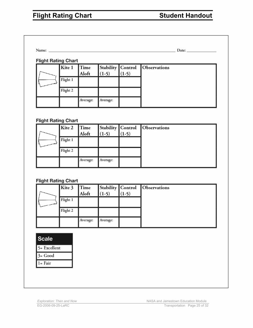
• Three sheets of 8 by 11-inch white paper • Metric ruler • Three wooden skewer sticks • Transparent tape • 10 meters of kite string • Small pieces of cardboard that can be used to wind kite string • One-hole punch • “Flight Rating Chart”
Exploration: Then and Now NASA and Jamestown Education Module EG-2006-09-25-LaRC Transportation Page 4 of 32
Explain Per student:
• “NASA and Jamestown Transportation Chart: Vessel Design” • “NASA and Jamestown Transportation Chart: Navigation” • “NASA and Jamestown Transportation Chart: Propulsion”
Extend Materials will vary depending on the propulsion experiment designed by the students, but may include plastic film canisters, vinegar, baking soda, and/or effervescent tablets.
Vocabulary astrolabe: an instrument used by navigators to determine latitude, longitude, and time of day by measuring the altitude of heavenly bodies
Global Positioning System (GPS): a satellite navigation system that gives special satellite signals that can be processed in a GPS receiver to compute position, velocity, and time
gravity well: the pull of gravity that a large body in space exerts; entering space from the surface of a planet means a spacecraft must have enough energy to overcome the gravitational pull of the planet, or be able to “climb out of the gravity well”
hypersonic: speeds that are greater than Mach 5, or about five times faster than the speed of sound (the speed of sound at the temperature and altitude planes fly is 1,225 kilometers per hour [761 miles per hour])
inertia: one of the properties of matter in which objects in motion remain in motion unless outside forces act to change the motion
inertial guidance systems: the use of a gyroscope to measure changes in speed and direction
latitude: the angular distance measured in degrees north or south of Earth’s equator
longitude: the angular distance of Earth’s surface measured in degrees east or west of the prime meridian at Greenwich, England
magnetic compass: an instrument that uses Earth’s magnetic field to point north
Exploration: Then and Now NASA and Jamestown Education Module EG-2006-09-25-LaRC Transportation Page 5 of 32
navigation: the science of plotting and following a course from one place to another and of determining the position of a moving ship, aircraft, or other vehicle
propulsion: a force that causes an object to move forward
shallop: a small, open boat fitted with oars or sails
trigonometry: a branch of mathematics that deals with the relationship of the sides and angles of triangles
Suggested Pacing:
50-minute class
periods 1 class period
(optional)
6 class periods
Engage Explore Explain Extend Evaluate Total
1 class period
3 class periods
1 class period
Completedthroughoutthe lesson
Instructional Procedure Teaching Suggestion: Prior to beginning this lesson, create a chart that is displayed throughout the lesson to help organize student learning. Ask the students to create similar charts in their journals. The charts may be formatted as follows, but should be large enough to organize information.
How do vessel design, navigation, and propulsion affect exploration?
JAMESTOWN MOON MARS
VESSEL DESIGN
NAVIGATION
PROPULSION
Engage 1. Discuss the following questions with the class:
• Have you ever been on a long trip? • How did you get where you were going? • What was good about the trip? • What were some of the problems?
2. Ask students to think about the journeys made by early explorers, such as the Jamestown settlers, or modern day explorers, such as the astronauts who traveled to the Moon. What kinds of problems might they have encountered?
Exploration: Then and Now NASA and Jamestown Education Module EG-2006-09-25-LaRC Transportation Page 6 of 32
3. Transportation is an issue faced by all explorers, whether setting out on a family vacation or traveling to a new world for the first time. Vessel design, including the shape and size of a vehicle, is important. The shape of the vehicle must serve the purpose of the trip and be large enough to carry both the explorers and their supplies. Ask students to draw a quick sketch of what they think the ships used by the Jamestown settlers might have looked like and to draw a sketch of the kind of vehicle the astronauts might use to return to the Moon in a few years. 4. Take the students to a large open area, such as a gymnasium or grassy area of the playground. 5. Have the students measure out an area that is 17 meters long by 5 meters wide (56 feet long by 16 feet wide). 6. Have the students mark the area using masking tape or string. This area will represent the deck size of the Godspeed, the middle-sized ship used by the Jamestown settlers.
Teaching Suggestion: Teachers may precut the string, eliminating the need to measure the area in order to save time.
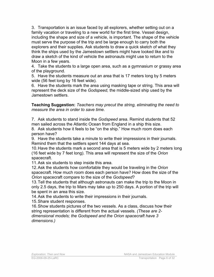
7. Ask students to stand inside the Godspeed area. Remind students that 52men sailed across the Atlantic Ocean from England in a ship this size.8. Ask students how it feels to be “on the ship.” How much room does eachperson have?9. Have the students take a minute to write their impressions in their journals.Remind them that the settlers spent 144 days at sea.10.Have the students mark a second area that is 5 meters wide by 2 meters long(16 feet wide by 7 feet long). This area will represent the size of the Orionspacecraft.11.Ask six students to step inside this area.12.Ask the students how comfortable they would be traveling in the Orionspacecraft. How much room does each person have? How does the size of theOrion spacecraft compare to the size of the Godspeed?13.Tell the students that although astronauts can make the trip to the Moon inonly 2.5 days, the trip to Mars may take up to 250 days. A portion of the trip willbe spent in an area this size.14.Ask the students to write their impressions in their journals.15.Share student responses.16.Show students pictures of the two vessels. As a class, discuss how theirstring representation is different from the actual vessels. (These are 2-dimensional models; the Godspeed and the Orion spacecraft have 3dimensions.)
Exploration: Then and Now NASA and Jamestown Education Module EG-2006-09-25-LaRC Transportation Page 7 of 32
Godspeed Orion spacecraft
17.Give the students the third dimension for each vehicle. For the Godspeed, a second deck about 1 meter (3 feet) shorter than the top deck is added. This deck is about 2 meters (7 feet) below the top deck. Point out that Orion is a gumdrop-shaped craft that is 5 meters (16 feet) at its widest point. On Orion, a height of nearly 3 meters (10 feet) is added to the interior space. 18.Ask students to decide whether the third dimension would make a difference in understanding how much space the explorers have. (Answers should explore the idea that a second deck will allow the people to spread out across the ship, but students should remember that the top deck is used to conduct sailing business, so there is not much excess room for the settlers. Because of the reduced-gravity environment of Orion, the additional space may give the astronauts a little more room, but part of the space is occupied by instruments that are used to navigate and control the spacecraft.) 19.Add any relevant information about vessel design to the class/student charts.
Assign Journal Prompt # 1 Using what you have learned from this activity, what do you think the next generation of exploration vehicles should look like? You may want to include illustrations to support your answer. How does vessel design affect exploration?
Explore Changes and improvements in navigation and propulsion affect exploration. These activities help your students understand some of these changes.
Activity One: Geospatial Technology Using geospatial technology, every feature on Earth’s surface is assigned a unique address. These addresses are expressed as coordinates, using latitude and longitude. One geospatial tool with which students may be familiar is the Global Positioning System (GPS). A GPS is able to show people their exact position on Earth. GPS satellites orbit at 20,000 kilometers (11,000 nautical miles) above Earth. The satellites transmit signals that can be detected with a GPS receiver. Each GPS satellite transmits data that indicate the satellite’s location and the current time. All GPS satellites synchronize operations so that these repeating signals are transmitted at the same instant. The signals, moving at the speed of light, arrive at a GPS receiver at slightly different times because some satellites are farther away than others. The distance to the GPS satellites can be determined by estimating the amount of time it takes for their signals to
Exploration: Then and Now NASA and Jamestown Education Module EG-2006-09-25-LaRC Transportation Page 8 of 32
reach the receiver. When the receiver estimates the distance to at least four GPS satellites, it can calculate a position in three dimensions.
1. Introduce the students to geospatial technology.
Teaching Suggestion: You may want to show the 30-second NASA KSNN™ (Kids Science News Network) video, “How can you find your place in space?” http://ksnn.larc.nasa.gov/webtext.cfm?unit=geospatial
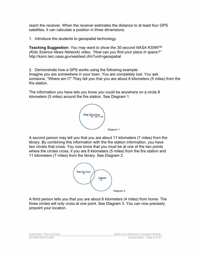
2. Demonstrate how a GPS works using the following example:Imagine you are somewhere in your town. You are completely lost. You asksomeone, “Where am I?” They tell you that you are about 8 kilometers (5 miles) from thefire station.
The information you have lets you know you could be anywhere on a circle 8 kilometers (5 miles) around the fire station. See Diagram 1.
Diagram 1
A second person may tell you that you are about 11 kilometers (7 miles) from the library. By combining this information with the fire station information, you have two circles that cross. You now know that you must be at one of the two points where the circles cross, if you are 8 kilometers (5 miles) from the fire station and 11 kilometers (7 miles) from the library. See Diagram 2.
Diagram 2
A third person tells you that you are about 6 kilometers (4 miles) from home. The three circles will only cross at one point. See Diagram 3. You can now precisely pinpoint your location.
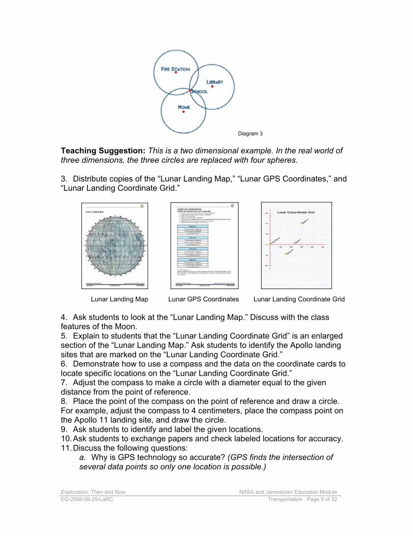
Exploration: Then and Now NASA and Jamestown Education Module EG-2006-09-25-LaRC Transportation Page 9 of 32
Diagram 3
Teaching Suggestion: This is a two dimensional example. In the real world of three dimensions, the three circles are replaced with four spheres.
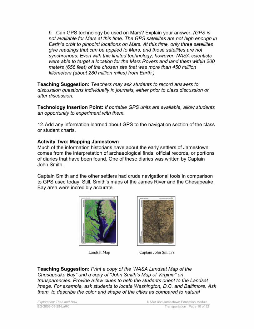
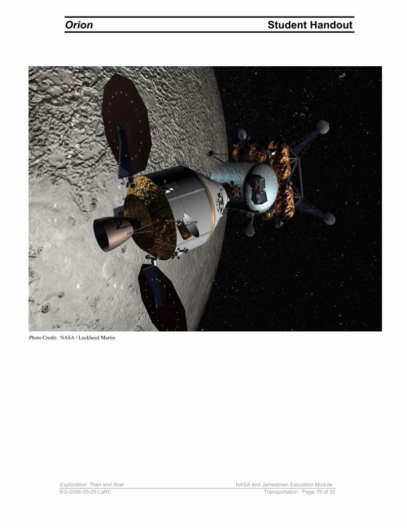
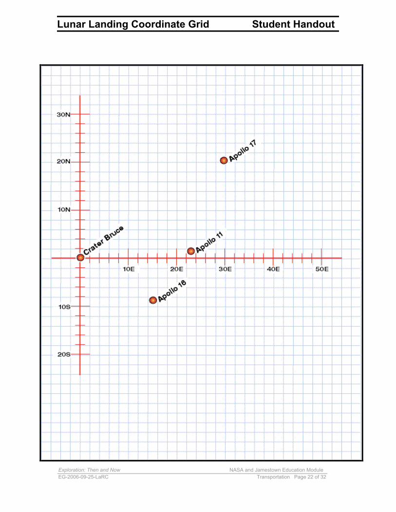
3. Distribute copies of the “Lunar Landing Map,” “Lunar GPS Coordinates,” and “Lunar Landing Coordinate Grid.”
Lunar Landing Map Lunar GPS Coordinates Lunar Landing Coordinate Grid
4. Ask students to look at the “Lunar Landing Map.” Discuss with the classfeatures of the Moon.5. Explain to students that the “Lunar Landing Coordinate Grid” is an enlargedsection of the “Lunar Landing Map.” Ask students to identify the Apollo landingsites that are marked on the “Lunar Landing Coordinate Grid.”6. Demonstrate how to use a compass and the data on the coordinate cards tolocate specific locations on the “Lunar Landing Coordinate Grid.”7. Adjust the compass to make a circle with a diameter equal to the givendistance from the point of reference.8. Place the point of the compass on the point of reference and draw a circle.For example, adjust the compass to 4 centimeters, place the compass point onthe Apollo 11 landing site, and draw the circle.9. Ask students to identify and label the given locations.10.Ask students to exchange papers and check labeled locations for accuracy.11.Discuss the following questions:
a. Why is GPS technology so accurate? (GPS finds the intersection of several data points so only one location is possible.)
Exploration: Then and Now NASA and Jamestown Education Module EG-2006-09-25-LaRC Transportation Page 10 of 32
b. Can GPS technology be used on Mars? Explain your answer. (GPS is not available for Mars at this time. The GPS satellites are not high enough in Earth’s orbit to pinpoint locations on Mars. At this time, only three satellites give readings that can be applied to Mars, and those satellites are not synchronous. Even with this limited technology, however, NASA scientists were able to target a location for the Mars Rovers and land them within 200 meters (656 feet) of the chosen site that was more than 450 million kilometers (about 280 million miles) from Earth.)
Teaching Suggestion: Teachers may ask students to record answers to discussion questions individually in journals, either prior to class discussion or after discussion.
Technology Insertion Point: If portable GPS units are available, allow students an opportunity to experiment with them.
12.Add any information learned about GPS to the navigation section of the class or student charts.
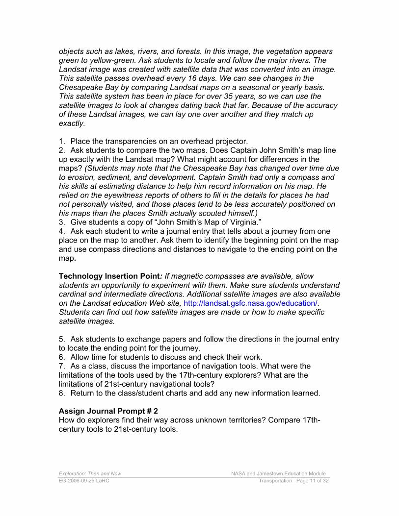
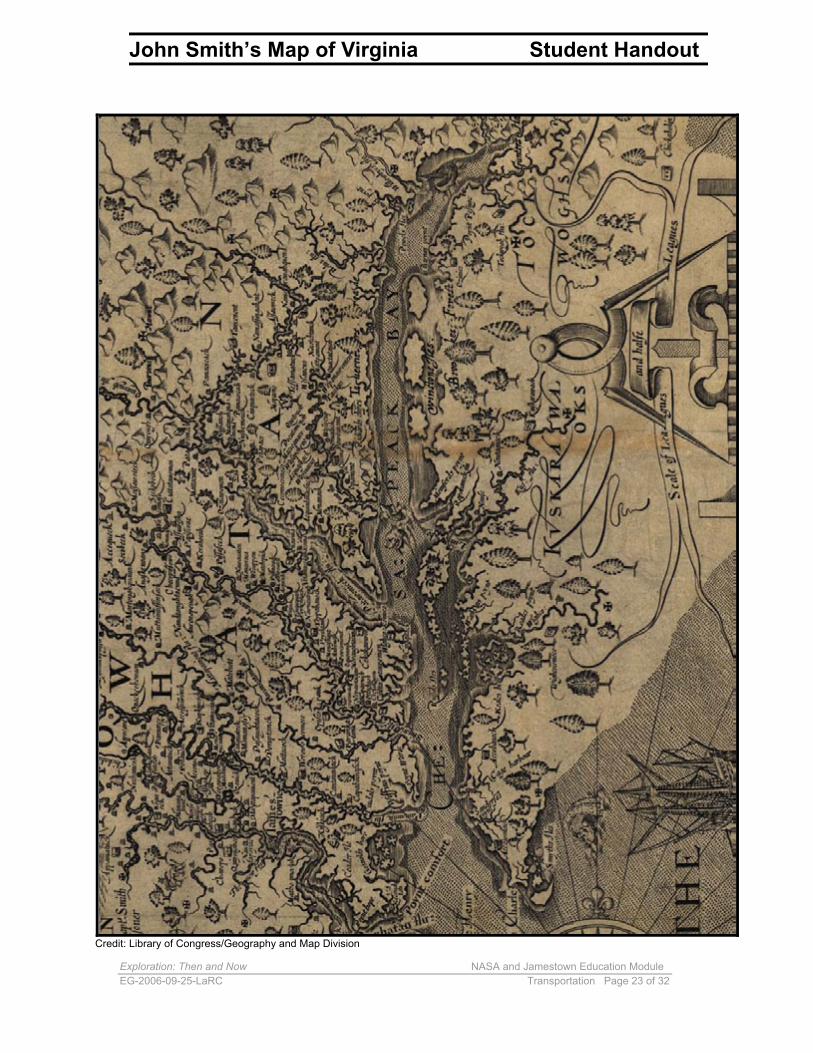
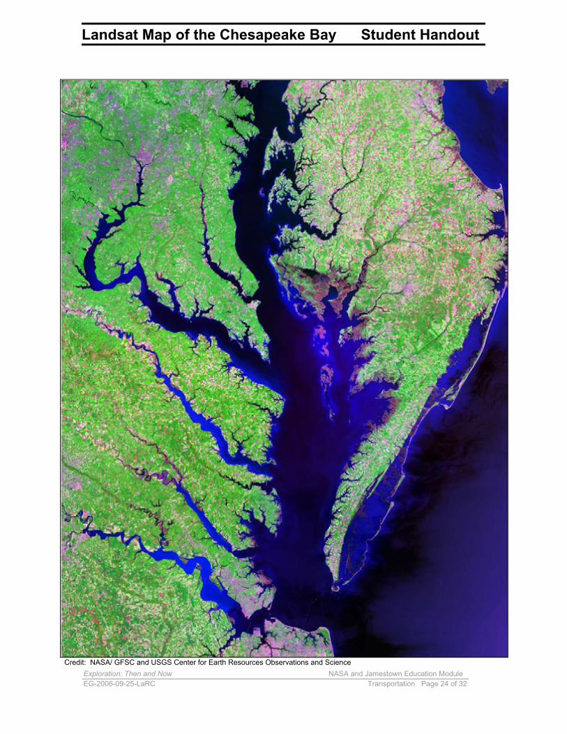
Activity Two: Mapping Jamestown Much of the information historians have about the early settlers of Jamestown comes from the interpretation of archaeological finds, official records, or portions of diaries that have been found. One of these diaries was written by Captain John Smith.
Captain Smith and the other settlers had crude navigational tools in comparison to GPS used today. Still, Smith’s maps of the James River and the Chesapeake Bay area were incredibly accurate.
Landsat Map Captain John Smith’s
Teaching Suggestion: Print a copy of the “NASA Landsat Map of the Chesapeake Bay” and a copy of “John Smith’s Map of Virginia” on transparencies. Provide a few clues to help the students orient to the Landsat image. For example, ask students to locate Washington, D.C. and Baltimore. Ask them to describe the color and shape of the cities as compared to natural
Exploration: Then and Now NASA and Jamestown Education Module EG-2006-09-25-LaRC Transportation Page 11 of 32
objects such as lakes, rivers, and forests. In this image, the vegetation appears green to yellow-green. Ask students to locate and follow the major rivers. The Landsat image was created with satellite data that was converted into an image. This satellite passes overhead every 16 days. We can see changes in the Chesapeake Bay by comparing Landsat maps on a seasonal or yearly basis. This satellite system has been in place for over 35 years, so we can use the satellite images to look at changes dating back that far. Because of the accuracy of these Landsat images, we can lay one over another and they match up exactly.
1. Place the transparencies on an overhead projector. 2. Ask students to compare the two maps. Does Captain John Smith’s map line up exactly with the Landsat map? What might account for differences in the maps? (Students may note that the Chesapeake Bay has changed over time due to erosion, sediment, and development. Captain Smith had only a compass and his skills at estimating distance to help him record information on his map. He relied on the eyewitness reports of others to fill in the details for places he had not personally visited, and those places tend to be less accurately positioned on his maps than the places Smith actually scouted himself.) 3. Give students a copy of “John Smith’s Map of Virginia.” 4. Ask each student to write a journal entry that tells about a journey from one place on the map to another. Ask them to identify the beginning point on the map and use compass directions and distances to navigate to the ending point on the map.
Technology Insertion Point: If magnetic compasses are available, allow students an opportunity to experiment with them. Make sure students understand cardinal and intermediate directions. Additional satellite images are also available on the Landsat education Web site, http://landsat.gsfc.nasa.gov/education/. Students can find out how satellite images are made or how to make specific satellite images.
5. Ask students to exchange papers and follow the directions in the journal entry to locate the ending point for the journey. 6. Allow time for students to discuss and check their work. 7. As a class, discuss the importance of navigation tools. What were the limitations of the tools used by the 17th-century explorers? What are the limitations of 21st-century navigational tools? 8. Return to the class/student charts and add any new information learned.
Assign Journal Prompt # 2 How do explorers find their way across unknown territories? Compare 17th-century tools to 21st-century tools.
Exploration: Then and Now NASA and Jamestown Education Module EG-2006-09-25-LaRC Transportation Page 12 of 32
Activity Three: Exploring Sail Size Ships of the 17th century were rigged with large, rectangular- or triangular-shaped sails to catch the wind and propel the ship forward. The stronger the wind, the faster the boat moved. The Godspeed sported sails with an area of about 225 square meters (2,422 square feet).
With only trade winds and ocean currents to propel ships, explorers were at the mercy of the weather and the water. If conditions were unfavorable, a ship simply dropped anchor and waited. The first fleet to Jamestown, for instance, anchored off the coast of Kent for 6 weeks until the wind blew in the right direction to enable the ships to sail down the English Channel.
Today, NASA is investigating the possibility of using solar sails to propel spacecraft of the future. Riding on the light from the Sun, solar sails may be used to deliver payloads to a variety of locations in our solar system. Just as the sailing ships of past centuries opened up new frontiers for affordable transport and exploration, solar sails offer revolutionary capabilities for in-space propulsion, transport, and exploration of Earth, the Sun, the planets, and even interstellar space.
A common misconception is that solar sails are pushed by the solar wind the same way sailboats are propelled by the wind on Earth. This is not exactly so. The density of solar-wind particles is so small that their combined pressure is much less than the pressure resulting from even a gentle breeze on Earth. The propulsive force for a solar sail comes from the pressure of the light particles from the Sun or from lasers. A solar sail is a very large mirror that reflects light. As the photons of light strike the sail and bounce off, they gently push the sail along by transferring momentum to the sail. Over time, the solar sail spacecraft constantly accelerates and achieves an ever-greater velocity. To perform at maximum efficiency, solar sails must have a large area to collect as much sunlight as possible and must be lightweight, durable, and temperature-resistant.
1. Assign students to groups of three or more. 2. Prepare kite tails in advance by cutting plastic trash bags into strips 2 centimeters by 200 centimeters. Each group needs three kite tails. 3. Have each student group construct three kites according to the following directions:
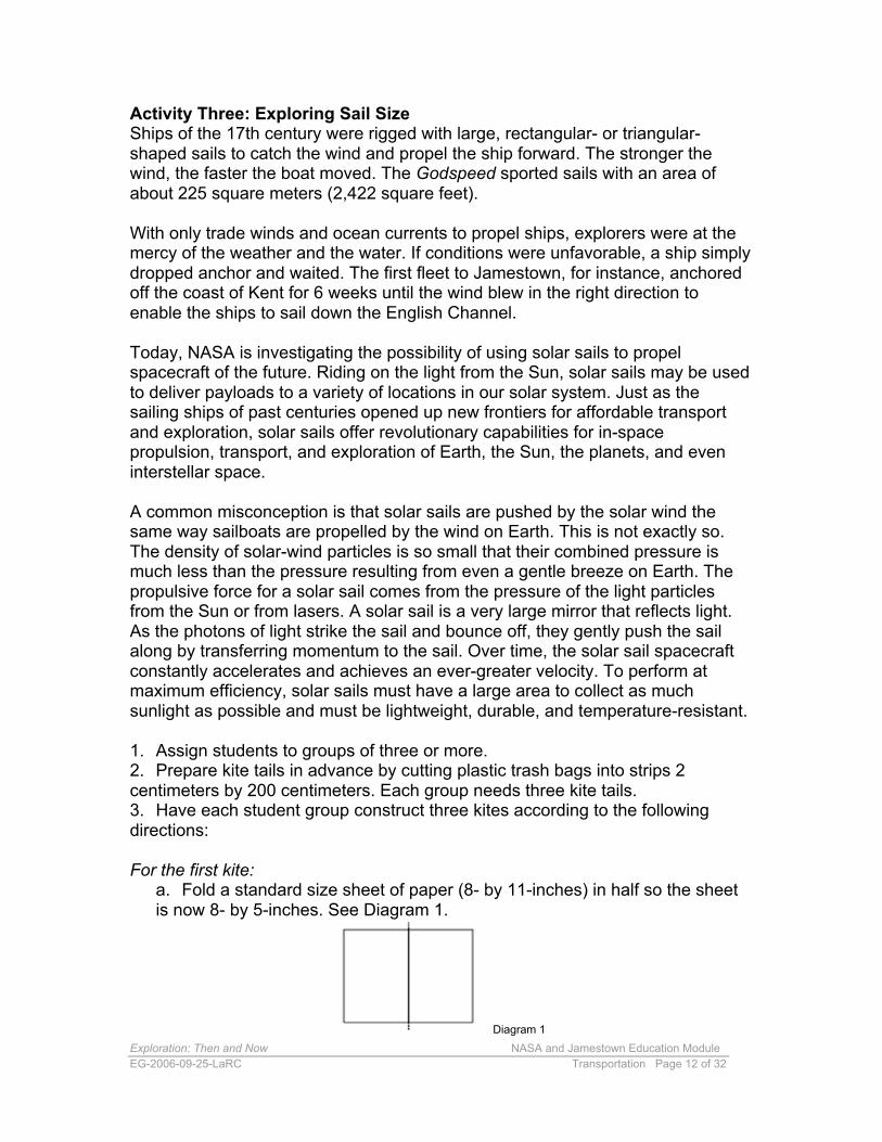
For the first kite: a. Fold a standard size sheet of paper (8- by 11-inches) in half so the sheet is now 8- by 5-inches. See Diagram 1.
Diagram 1
Exploration: Then and Now NASA and Jamestown Education Module EG-2006-09-25-LaRC Transportation Page 13 of 32
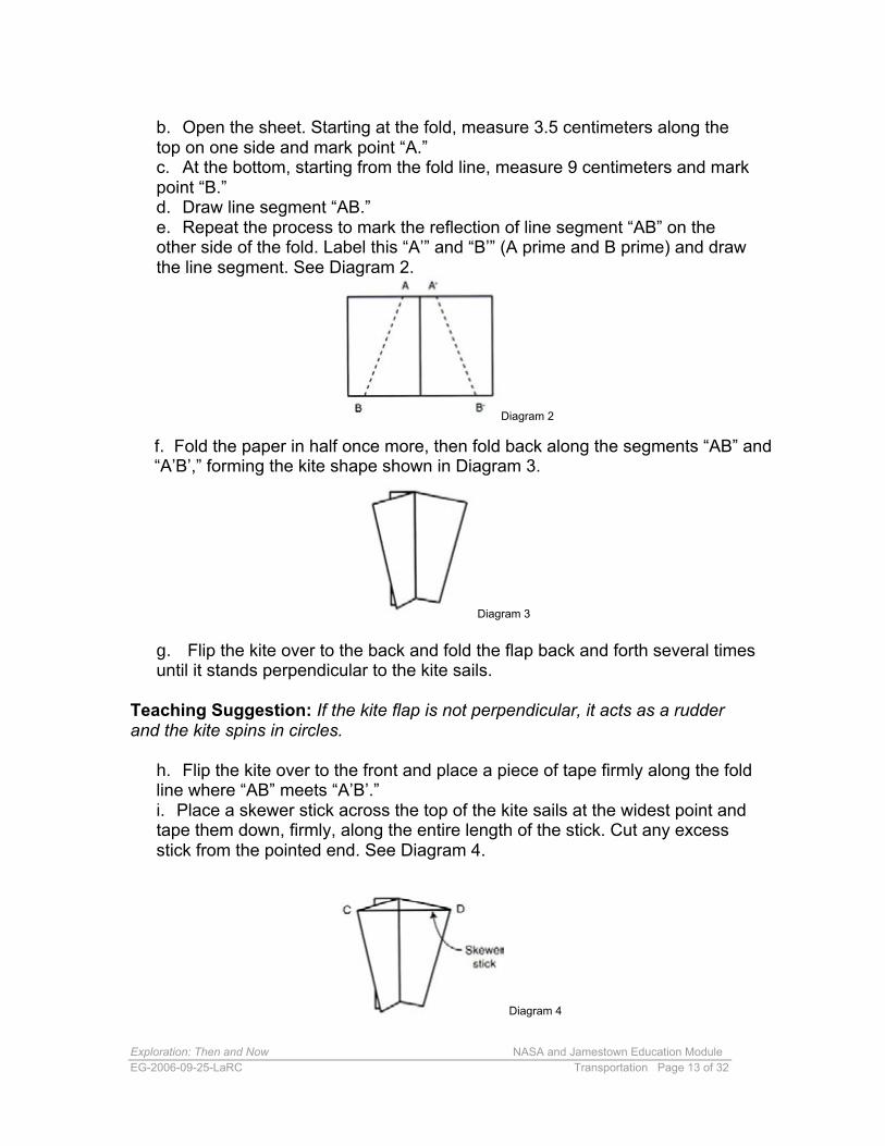
b. Open the sheet. Starting at the fold, measure 3.5 centimeters along the top on one side and mark point “A.” c. At the bottom, starting from the fold line, measure 9 centimeters and mark point “B.” d. Draw line segment “AB.” e. Repeat the process to mark the reflection of line segment “AB” on the other side of the fold. Label this “A’” and “B’” (A prime and B prime) and draw the line segment. See Diagram 2.
Diagram 2
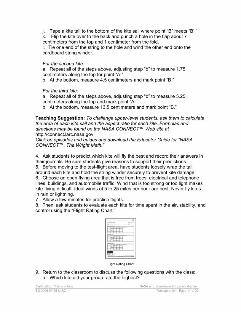
f. Fold the paper in half once more, then fold back along the segments “AB” and “A’B’,” forming the kite shape shown in Diagram 3.
Diagram 3
g. Flip the kite over to the back and fold the flap back and forth several times until it stands perpendicular to the kite sails.
Teaching Suggestion: If the kite flap is not perpendicular, it acts as a rudder and the kite spins in circles.
h. Flip the kite over to the front and place a piece of tape firmly along the fold line where “AB” meets “A’B’.” i. Place a skewer stick across the top of the kite sails at the widest point and tape them down, firmly, along the entire length of the stick. Cut any excess stick from the pointed end. See Diagram 4.
Diagram 4
Exploration: Then and Now NASA and Jamestown Education Module EG-2006-09-25-LaRC Transportation Page 14 of 32
j. Tape a kite tail to the bottom of the kite sail where point “B” meets “B’.” k. Flip the kite over to the back and punch a hole in the flap about 7centimeters from the top and 1 centimeter from the fold.l. Tie one end of the string to the hole and wind the other end onto the cardboard string winder.
For the second kite: a. Repeat all of the steps above, adjusting step “b” to measure 1.75centimeters along the top for point “A.”b. At the bottom, measure 4.5 centimeters and mark point “B.”
For the third kite: a. Repeat all of the steps above, adjusting step “b” to measure 5.25centimeters along the top and mark point “A.”b. At the bottom, measure 13.5 centimeters and mark point “B.”
Teaching Suggestion: To challenge upper-level students, ask them to calculate the area of each kite sail and the aspect ratio for each kite. Formulas and directions may be found on the NASA CONNECT™ Web site at http://connect.larc.nasa.gov. Click on episodes and guides and download the Educator Guide for “NASA CONNECT™, The Wright Math.”
4. Ask students to predict which kite will fly the best and record their answers in their journals. Be sure students give reasons to support their predictions. 5. Before moving to the test-flight area, have students loosely wrap the tail around each kite and hold the string winder securely to prevent kite damage. 6. Choose an open flying area that is free from trees, electrical and telephone lines, buildings, and automobile traffic. Wind that is too strong or too light makes kite-flying difficult. Ideal winds of 5 to 25 miles per hour are best. Never fly kites in rain or lightning. 7. Allow a few minutes for practice flights. 8. Then, ask students to evaluate each kite for time spent in the air, stability, and control using the “Flight Rating Chart.”
Flight Rating Chart
9. Return to the classroom to discuss the following questions with the class: a. Which kite did your group rate the highest?
Exploration: Then and Now NASA and Jamestown Education Module EG-2006-09-25-LaRC Transportation Page 15 of 32
b. What was the relationship between the surface area of the kites and their flight ratings? c. What are the advantages and disadvantages of relying on sails forpropulsion?d. Compare solar sails to ship sails. How are they the same? How are they different?
Teaching Suggestion: To extend this activity, ask students to attach their kites to a simple boat. Place the boats in a small wading pool and use a box fan for wind. Ask the students: Did the kites perform the same way on the water as they did in the air? What modifications could be made to the sails to make them more effective?
10.Add any new information students have learned about propulsion to the class and student charts.
Explain 1. Sir Isaac Newton is credited with saying, “If I have seen further than other men, it is by standing upon the shoulders of giants.” Post this quotation in the classroom. Ask students to explain what they think Newton meant by these words. 2. Transportation is dependent on the vessel design, navigation techniques used, and the propulsion that moves a vehicle from place to place. Ask students to read the three “NASA and Jamestown Transportation Charts” to find out more about the effect of vessel design, navigation, and propulsion on exploration at Jamestown, on the Moon, and on Mars.
NASA and Jamestown Transportation Charts
3. Pick out key ideas from the readings and include them in the class chart on transportation.
Extend 1. As we begin to explore further into our solar system, the need for navigational accuracy and speed becomes ever more important. Ask students to design experiments to test different types of propellants. They may want to visit one or more of the following Web sites for ideas:
Exploration: Then and Now NASA and Jamestown Education Module EG-2006-09-25-LaRC Transportation Page 16 of 32
NASA CONNECT™ “Festival of Flight Special: Opening Space for Next Generation Explorers” http://connect.larc.nasa.gov/programs/2002-2003/festival_flight/Festival_Flight.pdf
NASA KSNN™ 21st-Century Explorer“How Can We Travel Faster in Space?”http://ksnn.larc.nasa.gov/21Century/p4.html
2. Ask students to develop a multimedia presentation that shows the parallels between exploration of the past and the future. They may choose to focus on the themes of transportation: vessel design; navigation; and propulsion; or to include other themes of exploration, such as human needs; settlement; and the hunt for water. 3. Complete other lessons from the “Exploration: Then and Now,” NASA and Jamestown Education Module.
Evaluate Choose one or more of the following activities to assess student understanding.
1. Evaluate class/student charts for new information learned during these activities. 2. Assess students’ journal responses.
3. Ask students to apply what they have learned about transportation to future exploration. Have them plan to explore an unknown world; options may include another planet, a moon, the center of Earth, or an area beneath the ocean. Ask them to design a vehicle that is capable of making the trip and then describe the propulsion and navigation systems needed. Have students make presentations to their classmates.
Additional NASA Resources These additional NASA resources may extend student understanding about how vessel design, navigation, and propulsion affect exploration.
Vessel Design Designed for Grades 3-5 NASA KSNN™ 21st-Century Explorer “Designing a Crew Exploration Vehicle” Watch the NASA KSNN™ 21st-Century Newsbreak, “What will replace the shuttle?” and conduct the activity to design and build a Crew Exploration Vehicle that will be a model for future space exploration. http://ksnn.larc.nasa.gov/21Century/p5.html
Navigation Destination Mars: “Getting There—Navigation and Trajectory”
Exploration: Then and Now NASA and Jamestown Education Module EG-2006-09-25-LaRC Transportation Page 17 of 32
The year is 2018 and you must plot the paths of a spacecraft traveling between Earth and Mars. Plan the trajectory that will use the minimum amount of fuel and take about 6 months to complete. http://ares.jsc.nasa.gov/Education/activities/destmars/destmars/htm
The Landsat Program Discover classroom activities that use Landsat data and imagery. Landsat is a series of Earth-observing satellites jointly managed by NASA and the U.S. Geological Survey. The activity matrix helps locate activities based on grade level, product description, and keywords. http://landsat.gsfc.nasa.gov/education/activity_matrix.html
NASA SCI Files™ Designed for Grades 3-5 “The Case of the Technical Knockout” More activities about navigation of the past, magnetic compasses, global positioning satellites, and celestial navigation can be found in this NASA SCI Files™ Educator Guide. An accompanying video is also available. http://scifiles.larc.nasa.gov/educators/episodes/2004_2005/knockout/Tech_Knoc kout_Complete.pdf
Propulsion “Setting Sail for the Stars“Find out more about solar sails and how new technological developments andresearch could propel spacecraft into deep space.http://science.nasa.gov/headlines/y2000/ast28jun_1m.htm
Solar Sail Technology Learn about how solar sails work and the NASA mission scenarios that may use this technology in the future. http://solarsails.jpl.nasa.gov/
Exploration: Then and Now NASA and Jamestown Education Module EG-2006-09-25-LaRC Transportation Page 18 of 32
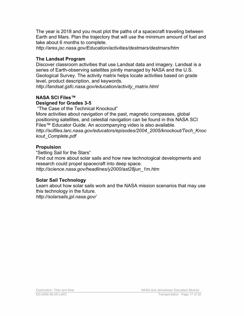
Godspeed Student Handout
Courtesy of Colonial National Historical Park
Exploration: Then and Now NASA and Jamestown Education Module EG-2006-09-25-LaRC Transportation Page 19 of 32
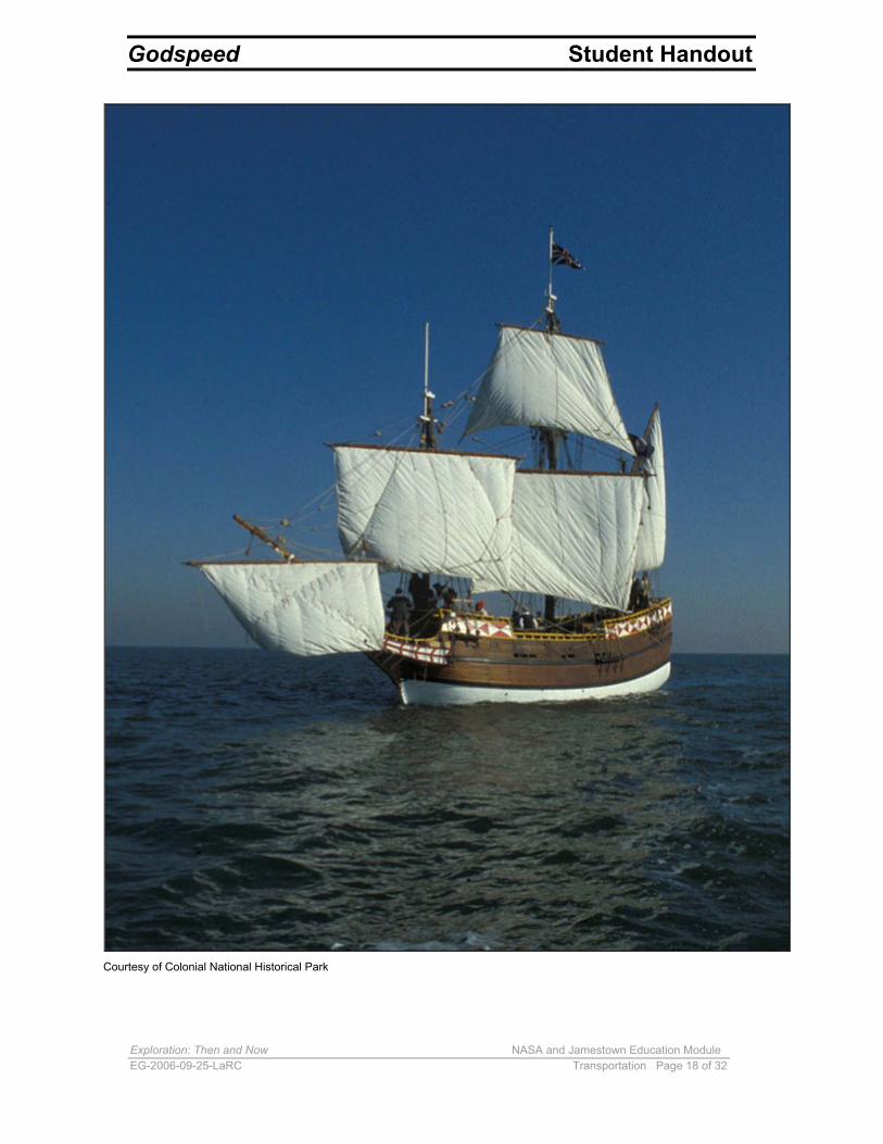
Orion Student Handout
Photo Credit: NASA / Lockheed Martin
Exploration: Then and Now NASA and Jamestown Education Module EG-2006-09-25-LaRC Transportation Page 20 of 32
Lunar Landing Map Student Handout
Credit: NASA/GSFC
Exploration: Then and Now NASA and Jamestown Education Module EG-2006-09-25-LaRC Transportation Page 21 of 32
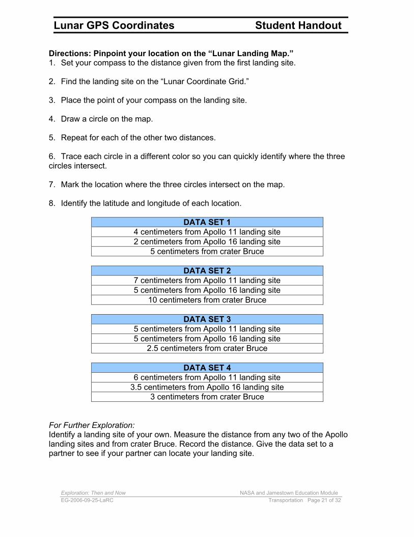
Lunar GPS Coordinates Student Handout
Directions: Pinpoint your location on the “Lunar Landing Map.” 1. Set your compass to the distance given from the first landing site.
2. Find the landing site on the “Lunar Coordinate Grid.”
3. Place the point of your compass on the landing site.
4. Draw a circle on the map.
5. Repeat for each of the other two distances.
6. Trace each circle in a different color so you can quickly identify where the three circles intersect.
7. Mark the location where the three circles intersect on the map.
8. Identify the latitude and longitude of each location.
DATA SET 1 4 centimeters from Apollo 11 landing site 2 centimeters from Apollo 16 landing site
5 centimeters from crater Bruce
DATA SET 2 7 centimeters from Apollo 11 landing site 5 centimeters from Apollo 16 landing site
10 centimeters from crater Bruce
DATA SET 3 5 centimeters from Apollo 11 landing site 5 centimeters from Apollo 16 landing site
2.5 centimeters from crater Bruce
DATA SET 4 6 centimeters from Apollo 11 landing site
3.5 centimeters from Apollo 16 landing site 3 centimeters from crater Bruce
For Further Exploration: Identify a landing site of your own. Measure the distance from any two of the Apollo landing sites and from crater Bruce. Record the distance. Give the data set to a partner to see if your partner can locate your landing site.
Exploration: Then and Now NASA and Jamestown Education Module EG-2006-09-25-LaRC Transportation Page 22 of 32
Lunar Landing Coordinate Grid Student Handout
Exploration: Then and Now NASA and Jamestown Education Module EG-2006-09-25-LaRC Transportation Page 23 of 32
John Smith’s Map of Virginia Student Handout
Credit: Library of Congress/Geography and Map Division
Exploration: Then and Now NASA and Jamestown Education Module EG-2006-09-25-LaRC Transportation Page 24 of 32
Landsat Map of the Chesapeake Bay Student Handout
Credit: NASA/ GFSC and USGS Center for Earth Resources Observations and Science
Exploration: Then and Now NASA and Jamestown Education Module EG-2006-09-25-LaRC Transportation Page 25 of 32
Flight Rating Chart Student Handout

Exploration: Then and Now NASA and Jamestown Education Module EG-2006-09-25-LaRC Transportation Page 26 of 32
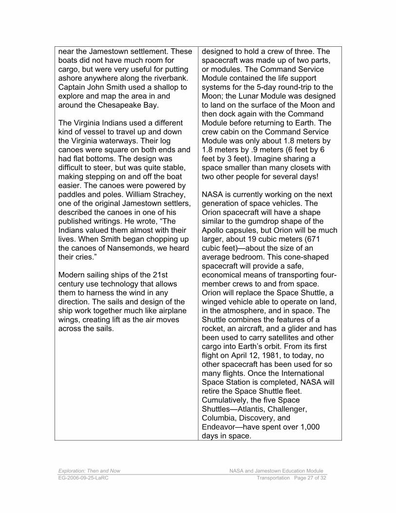
near the Jamestown settlement. Theseboats did not have much room forcargo, but were very useful for puttingashore anywhere along the riverbank.Captain John Smith used a shallop toexplore and map the area in andaround the Chesapeake Bay.
designed to hold a crew of three. Thespacecraft was made up of two parts,or modules. The Command ServiceModule contained the life supportsystems for the 5-day round-trip to theMoon; the Lunar Module was designedto land on the surface of the Moon and
NASA and Jamestown Transportation Chart: Vessel Design Student Handout
JAMESTOWN Ships in the 17th century, like ships of ancient times, were designed to sail with the wind behind them. These ships, known as “downwind sailers” could make little progress against winds from the wrong direction. Ships often had to wait at port or at sea for the right wind direction to continue their journeys. The rigs for these ships consisted of large square sails and the 75 lines used to control them.
Most sailing ships of the time were between 9 and 28 meters (30 and 90 feet) in length. The three ships that sailed to Jamestown in 1607, the Discovery, the Godspeed, and the Susan Constant, were no different.
The Discovery was the smallest of the three ships. She was 11.6 meters (38 feet) long at the waterline and could carry 21 people. This ship was about the size of a modern-day school bus.
The Godspeed was a larger ship, boasting a deck that measured 19.5 meters (64 feet). This ship carried 52 people and was a little larger than a modern-day semi-truck.
The third ship in the fleet, on which Captain Christopher Newport sailed, was the largest of the three. The Susan Constant was more than 23 meters long (76 feet) and carried 71 people. The Susan Constant was about the same length as a car on a modern-day passenger train.
Each ship carried smaller longboats, or shallops, that could be rowed and were used to explore the lakes and rivers
NASA Vessel design was very challenging at the dawn of space exploration. NASA scientists and engineers had to design and build craft that would withstand the extreme conditions experienced in the vacuum of space.
The first capsules to be shot into space were very small and designed only to hold a single crewmember. The total length of each of the Mercury capsules was only about 3.5 meters (11 feet) and the pressured volume was a small 1.5 cubic meters (55 cubic feet). In spite of being crammed into a vehicle not much larger than a refrigerator, Alan Shepard made history when he completed America’s first suborbital flight. John Glenn later became the first American astronaut to orbit Earth, spending 4 hours 55 minutes and 23 seconds in space.
The space program continued with the design of Gemini capsules, which were a bit larger, having a pressurized volume of nearly 2.3 cubic meters (80 cubic feet). These capsules were about the size of a phone booth or the front half of a Volkswagen Beetle, yet carried two crewmembers. Astronaut Pete Conrad once remarked that his time on Gemini 5 was like “spending 5 days in a garbage can.” Gemini gave U.S. astronauts their first real experience at living and working in space.
As NASA made plans to land on the Moon, a new capsule was designed. The Apollo capsules were much larger than the Gemini capsules, almost 6 cubic meters (210 cubic feet), and were
Exploration: Then and Now NASA and Jamestown Education Module EG-2006-09-25-LaRC Transportation Page 27 of 32
near the Jamestown settlement. These boats did not have much room for cargo, but were very useful for putting ashore anywhere along the riverbank. Captain John Smith used a shallop to explore and map the area in and around the Chesapeake Bay.
The Virginia Indians used a different kind of vessel to travel up and down the Virginia waterways. Their log canoes were square on both ends and had flat bottoms. The design was difficult to steer, but was quite stable, making stepping on and off the boat easier. The canoes were powered by paddles and poles. William Strachey, one of the original Jamestown settlers, described the canoes in one of his published writings. He wrote, “The Indians valued them almost with their lives. When Smith began chopping up the canoes of Nansemonds, we heard their cries.”
Modern sailing ships of the 21st century use technology that allows them to harness the wind in any direction. The sails and design of the ship work together much like airplane wings, creating lift as the air moves across the sails.
designed to hold a crew of three. The spacecraft was made up of two parts, or modules. The Command Service Module contained the life support systems for the 5-day round-trip to the Moon; the Lunar Module was designed to land on the surface of the Moon and then dock again with the Command Module before returning to Earth. The crew cabin on the Command Service Module was only about 1.8 meters by 1.8 meters by .9 meters (6 feet by 6 feet by 3 feet). Imagine sharing a space smaller than many closets with two other people for several days!
NASA is currently working on the next generation of space vehicles. The Orion spacecraft will have a shape similar to the gumdrop shape of the Apollo capsules, but Orion will be much larger, about 19 cubic meters (671 cubic feet)—about the size of an average bedroom. This cone-shaped spacecraft will provide a safe, economical means of transporting four-member crews to and from space. Orion will replace the Space Shuttle, a winged vehicle able to operate on land, in the atmosphere, and in space. The Shuttle combines the features of a rocket, an aircraft, and a glider and has been used to carry satellites and other cargo into Earth’s orbit. From its first flight on April 12, 1981, to today, no other spacecraft has been used for so many flights. Once the International Space Station is completed, NASA will retire the Space Shuttle fleet. Cumulatively, the five Space Shuttles—Atlantis, Challenger, Columbia, Discovery, and Endeavor—have spent over 1,000 days in space.
Exploration: Then and Now NASA and Jamestown Education Module EG-2006-09-25-LaRC Transportation Page 28 of 32
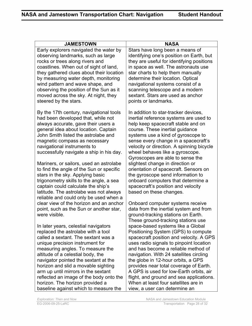
angle of the Sun, stars, or the Moon.By applying math skills and usingcharts, the navigator could calculatethe latitude and identify the ship’sposition on a map.
accurate, three-dimensional position inreal time.
NASA and Jamestown Transportation Chart: Navigation Student Handout
JAMESTOWN Early explorers navigated the water by observing landmarks, such as large rocks or trees along rivers and coastlines. When out of sight of land, they gathered clues about their location by measuring water depth, monitoring wind pattern and wave shape, and observing the position of the Sun as it moved across the sky. At night, they steered by the stars.
By the 17th century, navigational tools had been developed that, while not always accurate, gave their users a general idea about location. Captain John Smith listed the astrolabe and magnetic compass as necessary navigational instruments to successfully navigate a ship in his day.
Mariners, or sailors, used an astrolabe to find the angle of the Sun or specific stars in the sky. Applying basic trigonometry skills to the angle, a sea captain could calculate the ship’s latitude. The astrolabe was not always reliable and could only be used when a clear view of the horizon and an anchor point, such as the Sun or another star, were visible.
In later years, celestial navigators replaced the astrolabe with a tool called a sextant. The sextant was a unique precision instrument for measuring angles. To measure the altitude of a celestial body, the navigator pointed the sextant at the horizon and slid a movable sighting arm up until mirrors in the sextant reflected an image of the body onto the horizon. The horizon provided a baseline against which to measure the
NASA Stars have long been a means of identifying one’s position on Earth, but they are useful for identifying positions in space as well. The astronauts use star charts to help them manually determine their location. Optical navigational systems consist of a scanning telescope and a modern sextant. Stars are used as anchor points or landmarks.
In addition to star-tracker devices, inertial reference systems are used to help keep spacecraft stable and on course. These inertial guidance systems use a kind of gyroscope to sense every change in a spacecraft’s velocity or direction. A spinning bicycle wheel behaves like a gyroscope. Gyroscopes are able to sense the slightest change in direction or orientation of spacecraft. Sensors on the gyroscope send information to onboard computers that determine a spacecraft’s position and velocity based on these changes.
Onboard computer systems receive data from the inertial system and from ground-tracking stations on Earth. These ground-tracking stations use space-based systems like a Global Positioning System (GPS) to compute spacecraft position and velocity. A GPS uses radio signals to pinpoint location and has become a reliable method of navigation. With 24 satellites circling the globe in 12-hour orbits, a GPS provides near total coverage of Earth. A GPS is used for low-Earth orbits, air flight, and ground and sea applications. When at least four satellites are in view, a user can determine an
Exploration: Then and Now NASA and Jamestown Education Module EG-2006-09-25-LaRC Transportation Page 29 of 32
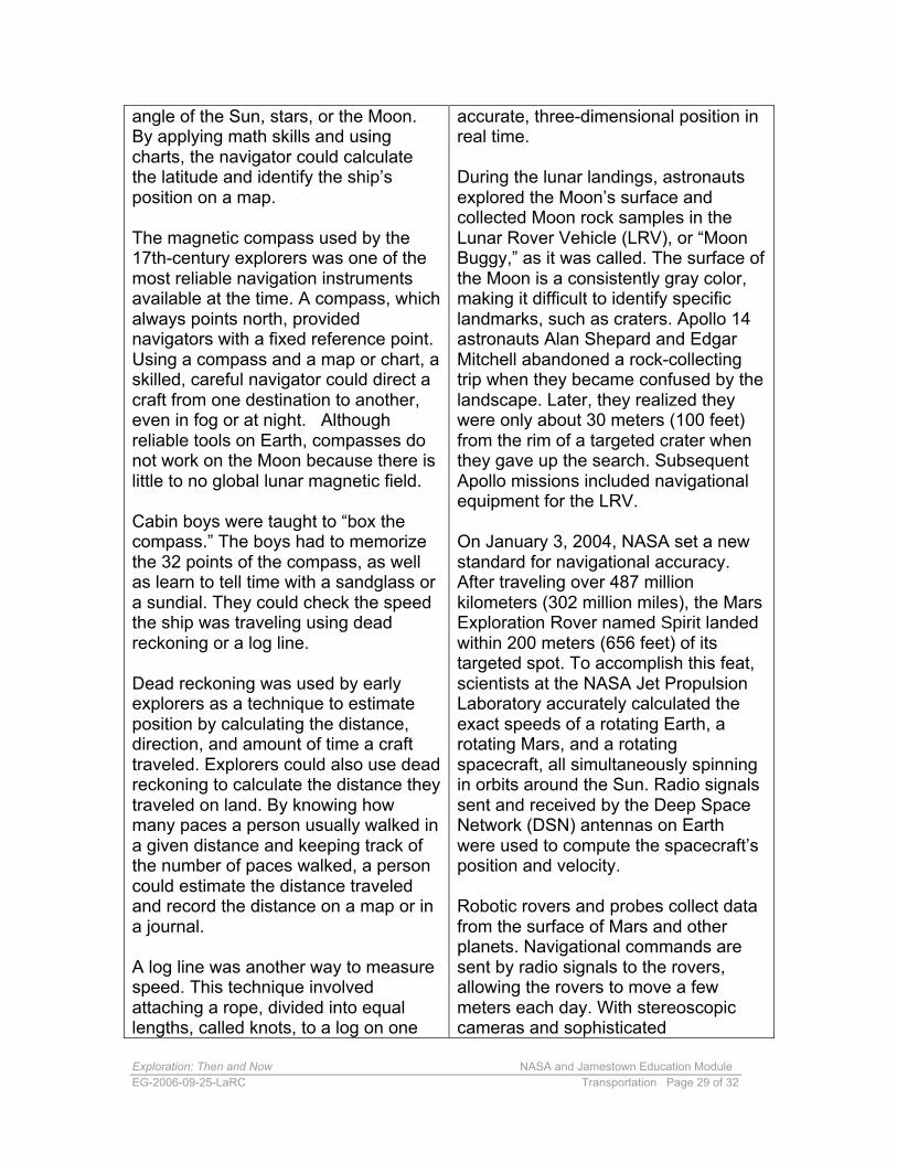
angle of the Sun, stars, or the Moon. By applying math skills and using charts, the navigator could calculate the latitude and identify the ship’s position on a map.
The magnetic compass used by the 17th-century explorers was one of the most reliable navigation instruments available at the time. A compass, whichalways points north, provided navigators with a fixed reference point. Using a compass and a map or chart, a skilled, careful navigator could direct a craft from one destination to another, even in fog or at night. Although reliable tools on Earth, compasses do not work on the Moon because there is little to no global lunar magnetic field.
Cabin boys were taught to “box the compass.” The boys had to memorize the 32 points of the compass, as well as learn to tell time with a sandglass or a sundial. They could check the speed the ship was traveling using dead reckoning or a log line.
Dead reckoning was used by early explorers as a technique to estimate position by calculating the distance, direction, and amount of time a craft traveled. Explorers could also use deadreckoning to calculate the distance theytraveled on land. By knowing how many paces a person usually walked in a given distance and keeping track of the number of paces walked, a person could estimate the distance traveled and record the distance on a map or in a journal.
A log line was another way to measure speed. This technique involved attaching a rope, divided into equal lengths, called knots, to a log on one
accurate, three-dimensional position in real time.
During the lunar landings, astronauts explored the Moon’s surface and collected Moon rock samples in the Lunar Rover Vehicle (LRV), or “Moon Buggy,” as it was called. The surface ofthe Moon is a consistently gray color, making it difficult to identify specific landmarks, such as craters. Apollo 14 astronauts Alan Shepard and Edgar Mitchell abandoned a rock-collecting trip when they became confused by the landscape. Later, they realized they were only about 30 meters (100 feet) from the rim of a targeted crater when they gave up the search. Subsequent Apollo missions included navigational equipment for the LRV.
On January 3, 2004, NASA set a new standard for navigational accuracy. After traveling over 487 million kilometers (302 million miles), the Mars Exploration Rover named Spirit landed within 200 meters (656 feet) of its targeted spot. To accomplish this feat, scientists at the NASA Jet Propulsion Laboratory accurately calculated the exact speeds of a rotating Earth, a rotating Mars, and a rotating spacecraft, all simultaneously spinning in orbits around the Sun. Radio signals sent and received by the Deep Space Network (DSN) antennas on Earth were used to compute the spacecraft’s position and velocity.
Robotic rovers and probes collect data from the surface of Mars and other planets. Navigational commands are sent by radio signals to the rovers, allowing the rovers to move a few meters each day. With stereoscopic cameras and sophisticated
end and a reel on the ship on the otherend. The knots were marked withcolored cloth that was tied to the rope.When a captain wanted to know howfast the ship was traveling, one of thesailors threw the log end of the ropeinto the water and counted the number
communication systems, the MarsRovers continue to explore the surfaceof Mars and send exciting newinformation about the planet’s surfaceback to Earth.
Exploration: Then and Now NASA and Jamestown Education Module EG-2006-09-25-LaRC Transportation Page 30 of 32
end and a reel on the ship on the other end. The knots were marked with colored cloth that was tied to the rope. When a captain wanted to know how fast the ship was traveling, one of the sailors threw the log end of the rope into the water and counted the number of knots that unwound from the reel in 30 seconds, as timed by a sandglass. Knots, spaced approximately 15 meters (50 feet) from the next knot, represent one nautical mile per hour, or about 1.8 kilometers per hour. An average sailing ship could, at that time, travel at a speed of about 6 knots per hour.
The English settlers drew careful maps and made notes about their locations, the plant and animal life they encountered, and their interactions with the native peoples. Captain John Smith’s map of Virginia was amazingly accurate, considering the crude navigational tools he had at his disposal.
communication systems, the Mars Rovers continue to explore the surface of Mars and send exciting new information about the planet’s surface back to Earth.
As technology improves, explorers will find new ways to map unknown worlds. Geographic Information Systems (GIS) create computerized maps with potentially unlimited amounts of information available for every point on the map. Stacking layers of information allows new patterns to emerge and can show change over time. Remote sensing and satellite imaging enable people to study and evaluate the dynamic changes on Earth. One example is the Landsat system, a series of Earth-observing satellites jointly managed by NASA and the U.S. Geological Survey that collect information about Earth from space. Today’s and future explorers will be able to use remote sensing to identify, measure, and observe planetary features without having to collect physical samples.
Exploration: Then and Now NASA and Jamestown Education Module EG-2006-09-25-LaRC Transportation Page 31 of 32
the sun is coated with a highly reflectivematerial so that the sail becomes a hugemirror. A typical solar sail is the size of afootball field. Even in space, particles aremoving at high enough speeds to exertpressure on a sail roughly similar to thatof wind blowing on sails on Earth. Solar
NASA and Jamestown Transportation Chart: Propulsion Student Handout
JAMESTOWN With only the winds and the currents to provide the propulsion to cross the ocean, ships of the 17th century were at the mercy of the weather and water conditions of the day. The first fleet to come to Jamestown anchored off the coast of Kent, England, for 6 weeks, waiting for the wind to push the three ships down the English Channel. During that time, precious supplies of fresh food and water were consumed as the passengers and crew stood by helplessly waiting for the winds to change. That first trip across the Atlantic Ocean to Jamestown took a total of 144 days.
Many sailors, especially those traveling from Europe to America, used the tradewinds to help them travel. The trade winds are regular, dependable winds that blow east to west at the 20 degree latitude. Sailors from Portugal, for instance, would ride the trade winds across the ocean to the Canary Islands. Then, they would rely on the “westerlies,” companions to the trade winds, to help them journey to the southern coast of Africa and finally back home to Lisbon.
As ships became powered by sources other than wind, shorter routes were found across the oceans. By the mid-1800s, the use of steam engines to power ships allowed captains to plot a more direct route across the ocean, thereby shortening travel times considerably.
NASA Traveling as fast as the speed of sound was once thought to be impossible, but aircraft today can easily fly at supersonic speeds. One NASA experimental plane, the X-43A, set a speed record of nearly Mach 10, or almost 10 times the speed of sound. The X-43A used a scramjet engine, a unique concept that combines hypersonic air-breathing technology with supersonic speeds. This technology, which scoops up the air around the aircraft as it moves forward, can only work in an atmosphere. There is no atmosphere between Earth and the Moon. In order to explore distant worlds, spacecraft must be designed to travel faster, withstand the harsh environment of space, and travel without the help of an atmosphere.
Chemical propulsion helped the Apollo astronauts travel to the Moon in 2.5 days at speeds faster than 39,000 kilometers per hour (more than 24,000 miles per hour). The Space Shuttle is propelled by an improved chemical-propulsion system that uses liquid and solid propellants. Traveling at approximately 29,000 kilometers per hour (18,000 miles per hour), the Shuttle orbits Earth every 90 minutes. The Shuttle, however, is not suited for long-duration flights beyond low-Earth orbit. NASA is continuing research on advanced chemical propulsion systems to make flying spacecraft out of Earth’s gravity well more reliable and efficient.
Just as the early explorers used sails to propel them across the oceans, NASA is developing solar-sail technology. Solar sails are large, flat, smooth sheets of very thin film supported by ultra-lightweight structures. The side of the film that faces
Exploration: Then and Now NASA and Jamestown Education Module EG-2006-09-25-LaRC Transportation Page 32 of 32
the Sun is coated with a highly reflective material so that the sail becomes a huge mirror. A typical solar sail is the size of a football field. Even in space, particles are moving at high enough speeds to exert pressure on a sail roughly similar to that of wind blowing on sails on Earth. Solar sails, however, do not harness the ionized particles from the Sun, known as solar winds. The density of solar-wind particles is so small that their combined pressure is much less than the pressure resulting from even a gentle breeze on Earth. The Sun, however, exerts a tiny but perpetual force on the solar sail as the photons of light strike the sail and bounce off the reflective surface. The momentum from these light particles is transferred to the sail, gently pushing the sail forward. Over days, weeks, and months, the snail-paced acceleration builds substantially, resulting in high-speed velocities.
“Gravity assist” is another space-flight technique that has helped propel a number of interplanetary missions, including Voyager, Galileo, and Cassini. Moving spacecraft use the gravitational field of the planets to increase speed and/or change course without using additional fuel. Commonly referred to as the “slingshot effect,” gravity assist is more like a pitched baseball that, when hit with a bat, soars out of the stadium in a different direction. One of the most dramatic applications of this technique occurred in 1970—the world watched as NASA used gravity assist to rescue the Apollo 13 astronauts. NASA astronauts and engineers were able to use the Moon’s gravity to turn the spacecraft around and send it safely back home.