2 geology and geophysics - husky energy...seismic stratigraphy have been fully integrated into a...
TRANSCRIPT
White Rose DA Volume 2 (Development Plan) • January 2001 Page 18
2 GEOLOGY AND GEOPHYSICS
This section summarizes the regional geology of the Jeanne d’Arc Basin and discusses the geology andgeophysics of the White Rose Field. Section 2.1 deals with the regional geology, including the tectonichistory, stratigraphy, structure and geochemistry, and then more specifically, the geology of the WhiteRose Field. Section 2.2 includes data obtained from seismic studies and the geophysical interpretation ofthe White Rose Field and Section 2.3 describes the reservoir maps generated from core and log data andreservoir modelling. The reservoir maps are provided in Appendix 2.A.
The section is organized as follows:
• Geology;
• Geophysics; and• Reservoir Maps.
2.1 Geology
This subsection describes the regional geology of the Jeanne d’Arc Basin and the geology specific to theWhite Rose Field.
2.1.1 Regional Setting
The White Rose Field is located on the eastern margin of the Jeanne d’Arc Basin, 350 km east-southeastof St. John’s and 50 km from both the Terra Nova and Hibernia fields (Figure 1.1-1). This sectiondescribes the regional setting of the Jeanne d’Arc Basin and is organized into the following:
• Regional Tectonic History;• Regional Stratigraphy and Depositional Environments;• Regional Structure; and• Regional Geochemistry.
White Rose DA Volume 2 (Development Plan) • January 2001 Page 19
2.1.1.1 Regional Tectonic History
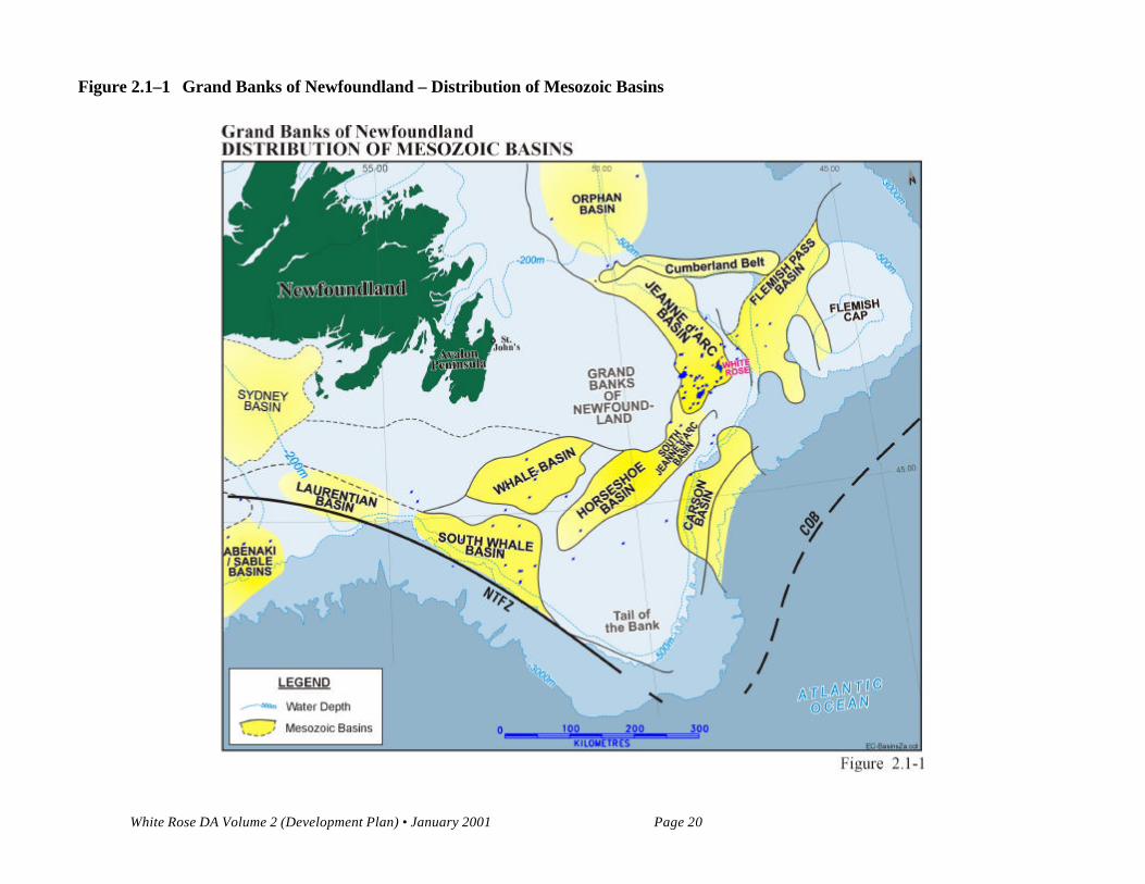
The Grand Banks rifted area is limited by the Bonavista Platform to the west, the Cumberland Belt-Flemish Cap (CBFC) Paleozoic lineament to the north, the continent-ocean boundary (COB) to the east,and the Newfoundland Transform Fault Zone (NTFZ) to the south (Figure 2.1-1). The western riftshoulder, the Bonavista Platform, is a submerged and peneplained sector of the Appalachian Orogen,partially covered by thin Upper Paleozoic, Mesozoic, and Cenozoic strata and situated landward from theMurre Fault. The Murre Fault is a regional basin-bounding, crustal penetrative fault dipping oceanward,which was crucial to the formation of basins on the Grand Banks. The NTFZ is a major ocean transformfault that was active during the separation of North America from Africa/Iberia.
A series of interconnected sedimentary basins, including the Jeanne d’Arc, were formed on the GrandBanks of Newfoundland as a result of Early Mesozoic break-up of the Pangea continental mass and birthof the Atlantic (Figure 2.1-1). The network of basins (South Whale, Whale, Horseshoe, Carson, FlemishPass and Jeanne d’Arc), adjacent sub-basins (Flemish Cap, Anson Graben, Salar) smaller troughs andcuvettes, have had a common evolution, though differences in their structure and stratigraphy exist. Theyare separated by elongate basement ridges bounded by faults that are linked at depth to the Murredetachment fault.
Three major Mesozoic rifting episodes affected the Grand Banks:
1) Tethys phase (Late Triassic-Early Jurassic). During this rifting episode the main basins wereformed as half-grabens in the downthrown side of a major crustal detachment. The failed rift wasfollowed by Atlantic opening south of the Grand Banks, on the Scotian margin.
2) North Atlantic phase (Late Jurassic-Early Cretaceous). Previously formed basins and newsedimentary troughs were affected by north-south trending faulting. The Jeanne d'Arc basin wasreactivated along the Egret Fault, that forms its current southern boundary, and along the VoyagerFault, with the Central Ridge area emerging as a regional high. The southern Grand Banks area,known as the Avalon Uplift, which includes a series of rift basins, was uplifted and eroded. TheAtlantic Ocean was opened south of the NTFZ. The Egret source rock was deposited during thethermal sag interlude within the Kimmeridgian.
3) Labrador phase (Mid to Late Cretaceous). During this episode numerous northwest-southeasttrending faults severely fragmented the basins and intervening ridges. In the Jeanne d’Arc Basin,the Trans Basin Fault Zone (TBFZ) was formed. Also, several imbricates of the Voyager Faultcreated terraces along the basin's eastern margin. The Avalon Formation sandstone reservoir wasdeposited on the eastern flank of the White Rose structural high. The Atlantic Ocean opened,separating the Grand Banks from Iberia and the British Isles.
White Rose DA Volume 2 (Development Plan) • January 2001 Page 20
Figure 2.1–1 Grand Banks of Newfoundland – Distribution of Mesozoic Basins
White Rose DA Volume 2 (Development Plan) • January 2001 Page 21
Each of the described rifting episodes had associated tectonic subsidence and was followed by post-riftthermal subsidence. The Tethys failed rift episode was the most important and defined the configurationand size of the basins. It was followed by a passive margin phase while the subsequent rifting episodesrejuvenated existing basins and opened new depositional areas.
Extensional and minor trans-tensional tectonic movements, accompanied by salt movement and severalerosional interludes, have shaped the basin sedimentary fill. The basin infill can be divided into:
1. Extensional stage sedimentary sequences (Late Triassic-Early Cretaceous). These are stronglycompartmentalized by normal fault systems and contains numerous structures;
2. Thermal subsidence stage sedimentary sequences (Late Albian to Present). These are usuallytectonically undisturbed (that is, no extension) but contain depositional and erosional features.
Alongside extensional tectonics, halokinesis and halotectonics played an important role in basin evolutionand structure. Prominent salt-cored structures are presently found throughout the Grand Banks. Saltfeatures are interpreted to underlie the Hibernia, Terra Nova and White Rose fields.
2.1.1.2 Regional Stratigraphy and Depositional Environments
High resolution biostratigraphy, sequence stratigraphy, and workstation-based three-dimensional (3-D)seismic stratigraphy have been fully integrated into a tectono-stratigraphic framework (Figure 2.1-2) todevelop an understanding of the stratigraphy of the Jeanne d’Arc Basin. This has been essential for thedefinition of unconformities, their relationship to tectonics and subsequent reservoir development. It isparticularly true for the Avalon and Ben Nevis Formations within the basin and how their tectono-stratigraphic definition is carried into the White Rose area.
Principal Reservoirs
Beginning in the mid-Kimmeridgian, several cycles of coarse-grained clastics were deposited throughoutthe Late Jurassic and Early Cretaceous. These are the primary hydrocarbon reservoirs in the basin. TheKimmeridgian Jeanne d’Arc Formation sandstones unconformably overlie the source and are thereservoirs at Terra Nova. The Berriasian-Valanginian Hibernia Formation sandstone is the primaryreservoir at the Hibernia Field. The Aptian Avalon Formation sandstones contain the reserves at WhiteRose and North Ben Nevis. The Albian Ben Nevis Formation are the sandstone reservoirs at Hebron,West Ben Nevis and Ben Nevis.
White Rose DA Volume 2 (Development Plan) • January 2001 Page 22
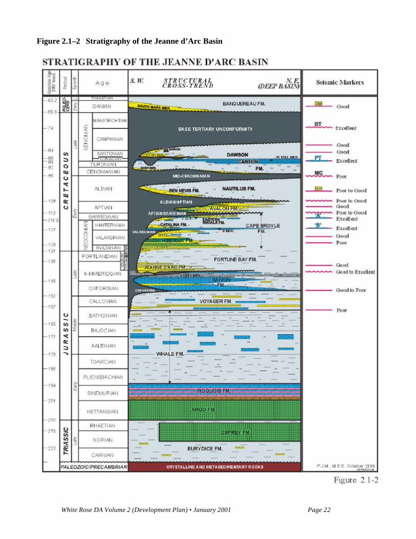
Figure 2.1–2 Stratigraphy of the Jeanne d’Arc Basin
White Rose DA Volume 2 (Development Plan) • January 2001 Page 23
Triassic-Mid. Jurassic Mega-Sequence: The Early Mesozoic break-up of Pangea was a complex processwhich resulted in the formation of a several fault-bounded Mesozoic rift basins, one of which was theJeanne d’Arc. Sedimentation was initiated during the Late Triassic when a classic rift sequencedeveloped over the Grand Banks. The sequence commenced with deposition of continental red beds ofthe Eurydice Formation, followed by restricted marine evaporite facies of the Argo Formation. Theoverlying Lower Jurassic Iroquois Formation, consisting of interbedded carbonates and evaporites,indicates a transition to a more open marine environment which continued with the deposition of theMiddle Jurassic Whale Formation shales and carbonates. The overlying Voyager Formation consists ofinterbedded limestone, shale and sandstone, the latter exhibiting poor to fair porosity, and may havegenerated minor amounts of the oil in the Jeanne d’Arc Basin.
Oxfordian-Mid. Kimmeridgian Mega-Sequence: The Upper Jurassic Rankin Formation is composed ofmarls, oolitic limestones, shales and carbonate-cemented sandstones, some with minor porosity. Thecarbonates create important seismic reflectors throughout the Jeanne d’Arc, even at considerable depth.Most importantly, the major source rock, the Egret Member, is found near the top of the formation. Itconsists of marls and organic rich laminated shales deposited in a silled basin during this highstand event.Uplift and renewed rifting of the Grand Banks during the Late Jurassic is indicated by the angular mid-Kimmeridgian Unconformity, with subsequent deposition of coarse clastics of the Jeanne d’ArcFormation sandstones.
Mid. Kimmeridgian-Valanginian Sequence: Beginning at the mid-Kimmeridgian and continuing into theEarly Cretaceous, sandstones were transported into the basin from the southwest. This entry point wasstructurally controlled, bounded in the west by the Murre Fault and to the east by the Voyager Fault.Tectonic uplift and the associated lowstand event formed multiple incised valleys into the underlyingnorth-northeast dipping Rankin Formation, south and southwest of the Terra Nova field.
The Jeanne d’Arc Formation sandstones are the primary reservoir at Terra Nova, forming laterallycontinuous braidplain to marine sandstones. They have also tested oil throughout the southwest part ofthe basin at Hebron, West Ben Nevis, Hibernia and King’s Cove. Away from the depositional trend, andwhere they are more deeply buried at Hibernia, reservoir quality deteriorates. The overlying Fortune Bayshales and siltstones form hydrocarbon seals and indicate a major transgression. This highstand cyclereached a maximum near the end of the Jurassic, and is followed by increasing silt content towards thetop of the Fortune Bay. Shallowing water and increasing coarse clastic content culminated in thedeposition of the regressive Lower Cretaceous Hibernia Formation sandstones.
The Hibernia Formation can be subdivided into a lower and upper section, separated by a middle shaleunit. The Lower Hibernia sandstones are widely distributed, beginning with a basal upward-coarsening,prograding sandstone, overlain by fluvial and shallow marine bars and channels. The Upper Hiberniasandstones are present in the shallower southwest part, and on the flanks of the Jeanne d’Arc Basin.Siltstones, minor sandstones and shales extend into the central basin as a more marine deposit. Hibernia
White Rose DA Volume 2 (Development Plan) • January 2001 Page 24
Formation reservoir quality is excellent at Hibernia, decreases at Hebron, and has low permeabilities atWhite Rose. At White Rose, the Upper Hibernia Formation is restricted to the south, towards Archer K-19, while the Lower Hibernia is present as a more distal facies, with much lower net to gross ratios thanelsewhere in the basin. North of White Rose, at Trave E-87, the depositional limit of the sandstone hasnearly been reached.
Hauterivian-Upper Barremian Sequence: Near the end of Hibernia Formation deposition in the LateValanginian, minor uplift occurred, resulting in erosion and non-deposition in the southern Jeanne d’Arcand on the flanks of the basin. A subsequent marine transgression allowed the deposition of a widespreadoolitic limestone, the B Marker. This unit is regionally correlatable on logs and creates an excellentseismic marker. In the southern and western part of the basin, this was followed by the deposition of theCatalina Formation, an interbedded calcareous limestone/sandstone, which forms a minor reservoir at theHibernia Field. Elsewhere, the Cape Broyle Formation siltstones and shales were deposited, as a majortransgression advanced over the entire basin, culminating in maximum flooding in the Late Hauterivian.Deposition of Hauterivian aged coarse clastics is restricted to the basin flanks. These clastics mark theonset of the Eastern Shoals Formation, a time transgressive, shallowing-upward sandstone/limestone unitwith minor porous intervals. Development of shallow marine limestones, which are locally correlateablewithin this unit, was common during the Early Barremian, and are locally referred to as the A Marker, Asandstone or A limestone.
Subsidence and faulting continued on the basin margins in the Jeanne d’Arc Basin during the EarlyCretaceous. Based on isochron and well isopach data, minor east-west extension had ended by the LateHauterivian. In the Late Barremian major tectonism was renewed. The shallowing-upward EasternShoals Formation culminates in non-marine to brackish sediments over most of the Jeanne d’Arc Basin,although shallow marine sandstones and shales are more prevalent in the White Rose area. Much of theyounger Barremian aged sections has been eroded because of continued uplift during the Early Aptian inthe southern White Rose area.
Aptian-Upper Albian/mid-Cenomanian Sequence: The Eastern Shoals Formation is unconformablyoverlain by the Avalon Formation of Aptian age, which consists of stacked aggradational shorefacesandstone units, culminating in an upward-fining shaly siltstone. Typically, the Avalon sandstones arecleaner and finer grained in the White rose area, compared to the Avalon found in the central and westernJeanne d’Arc Basin. The Avalon Formation on the eastern flank of the basin unconformably overliesconsiderably older Lower Cretaceous section. In the Archer K-19 well, Upper Hibernia sandstonessubcrop beneath the Avalon, removing the Barremian-Hauterivian section compared to other White Rosewells. As indicated by the White Rose A-90 well, erosion appears to have removed most of theNeocomian sandy section south and east of Archer K-19 and White Rose E-09. This huge volume ofclastic sediment was subsequently re-deposited as the Avalon Formation at White Rose.
White Rose DA Volume 2 (Development Plan) • January 2001 Page 25
Tectonic activity in the basin centre culminated towards the end of the Aptian or early Albian when theuplifted TBFZ collapsed during a final episode of northeast-southwest extension, allowing deposition ofthe Albian aged Ben Nevis Formation in the resulting subsiding grabens, as found at Ben Nevis I-45.This formation was deposited during Albian transgression, filling accommodation space resulting fromongoing tectonic extension, initially as coarse clastic deposits, grading to lower shoreface and inner shelfsilty sandstones as water depths increased. The formation shales out in a northerly and westerly directionas indicated by Albian deposition in North Ben Nevis and in the White Rose area. These overlyingsiltstones and calcareous shales are the Nautilus Formation and provide a regional seal.
Late Albian-Tertiary: The final thermal subsidence stage of the Jeanne d’Arc Basin has been ongoingsince the end of the Lower Cretaceous, although a period of uplift allowed deposition of the Cenomanianshallow marine Eider Formation north of the North Ben Nevis field. For the most part, siltstones andshales of the Nautilus Formation filled topographic relief, followed by the marls and shales of theDawson Canyon Formation, which blanketed the entire basin. Reactivation of a few fault blocks hasoccurred in some instances, such as at Mara M-54, where uplift and subsequent erosion has left a verythin Albian section underlying a Coniacian clastic wedge. A number of westerly-sourced clastic wedges,either submarine fans or fan deltas, are found on the western flank of the Jeanne d’Arc Basin in theuppermost Cretaceous and Tertiary. These are the Otter Bay, Fox Harbour and South Mara members,respectively. The South Mara is more widespread, extending to the western flank of White Rose, on theeastern side of the basin.
2.1.1.3 Regional Structure
The structural interpretation of the Jeanne d’Arc Basin is based on in-house and published regionalseismic interpretations performed on widespread seismic horizons such as Base Tertiary, Petrel, AMarker, B Marker, Top Rankin/Kimmeridgian Unconformity, inferred Top Salt and inferred AcousticBasement. These horizons were correlated to geological events intersected in some 40 wells drilled in thebasin. Timing of structural and tectonic events was completed by using biostratigraphic analysis, isopachmaps and palinspastic reconstructions.
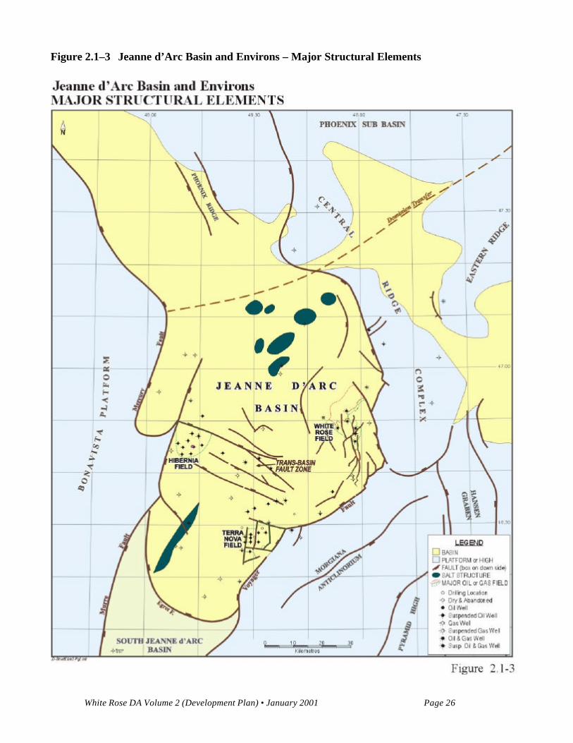
The Jeanne d’Arc Basin is a fault-bounded Late Jurassic-Early Cretaceous reactivated sector of a largerLate Triassic-Early Jurassic depositional area on the Grand Banks. The basin forms an elongate troughtrending north-northwest south-southeast, encompassing an area of roughly 10,500 km2, bounded by theMurre Fault to the west, the CBFC lineament to the north, the Voyager fault zone to the east and theEgret Fault to the south (Figure 2.1-1). The basin tapers and shallows to the south. Over 20 km of UpperTriassic to Cenozoic sedimentary infill is present in its depocentre situated north of the TBFZ. Virtuallyall significant hydrocarbon discoveries in the Grand Banks are confined to the Jeanne d’Arc Basin(Figures 2.1-3 and 2.1-4).
White Rose DA Volume 2 (Development Plan) • January 2001 Page 26
Figure 2.1–3 Jeanne d’Arc Basin and Environs – Major Structural Elements

White Rose DA Volume 2 (Development Plan) • January 2001 Page 27
Figure 2.1–4 Jeanne d’Arc Basin and Environs – Salt Distribution and Major Sedimentary
Structures
White Rose DA Volume 2 (Development Plan) • January 2001 Page 28
Late Triassic to Early Jurassic extension created the Jeanne d’Arc Basin as a half-graben on thedownthrown side of a major basin forming detachment fault, known as the Murre-Mercury Fault. Thisextensional fault system, its associated antithetic and synthetic faults and its conjugated shear faults,compartmentalize the basin into numerous fault blocks. Major boundary faults, such as Murre, Voyagerand Egret, are separated by relay ramps that accommodated diminishing extension on one fault andincreasing slip on the other fault. During this rifting stage the major internal architecture of the Jeanned'Arc Basin was established. The Upper Triassic-Lower Jurassic salt (Osprey and Argo formations)deposited in the incipient rift basin now underlies most of the basin, and forms salt pillows, diapirs andridges (Figure 2.1-4). Salt induced structural and stratigraphic features are likely responsible for theformation of the White Rose structural complex. Thermal sag followed the initial rifting phase.
Jeanne d’Arc Basin extension continued during the Late Jurassic to Early Cretaceous phase of riftingcharacterized by a dominant east-west direction of extension. Basin growth occurred on the boundingfaults, Murre and Voyager, and at its southern extremity marked by the Egret fault. Uplift, non-deposition and erosion affected a broad region in the southern Grand Banks, including portions of theJeanne d’Arc Basin. Developing as a separate block in the footwall of the Voyager Fault, the CentralRidge started to emerge as a prominent and permanent regional high. Numerous north-south faultsformed, especially on the Central Ridge and in the eastern portion of the basin where the White Rosefield is located. Salt diapirs and salt cored ridges were formed, influencing sedimentation and local faultpatterns.
In the Early Cretaceous, unconformities that developed during the Late Barremian to Early Albian markthe approximate end of the second rift phase in the Jeanne d’Arc Basin and the beginning of separationbetween the Grand Banks and Europe. Successive sag, rifting and then, ocean opening took place duringthis period. During the Aptian to Albian, northeast-southwest extension and block reorganization tookplace in the centre and along the margins of the Jeanne d’Arc Basin.
In the central part of the basin, towards the end of the Aptian, the TBFZ collapsed during majornortheast-southwest extension, allowing deposition of Albian aged clastics (Ben Nevis Formation) intothe subsiding grabens and low fault blocks. Clastics were deposited in a northerly direction reaching thewestern part of the White Rose Complex, but they exhibit poor reservoir properties. In the White Rosearea, towards the end of the Barremian, important salt movement occurred, particularly under the NorthAmethyst structure, Trepassey Depression and on the White Rose salt dome area (Figure 2.1-5).Concurrently, significant erosion of older pre-Barremian clastics and sediment redeposition took placeduring the Aptian in these areas.

White Rose DA Volume 2 (Development Plan) • January 2001 Page 29
Figure 2.1–5 White Rose Complex – Regional Composite Marker Time Structure
White Rose DA Volume 2 (Development Plan) • January 2001 Page 30
There is some uncertainty as to the age of the last rifting episode in the basin. In the White Rose/Amethyst area, the post-Avalon unconformity of late Albian age, may mark the cessation of extensionalevents. However, small block readjustments took place up to Paleocene time.
The Base Tertiary unconformity configuration reflects tilting of the basin and thickening of post-riftsediments toward the north. Late salt movements and compaction rejuvenated a few larger faults. Thesefaults (for example, Amethyst Fault) penetrate the unconformity and terminate in lower Tertiarysediments forming tectonic lineaments and sedimentary features, but no major structural closures.
2.1.1.4 Regional Geochemistry
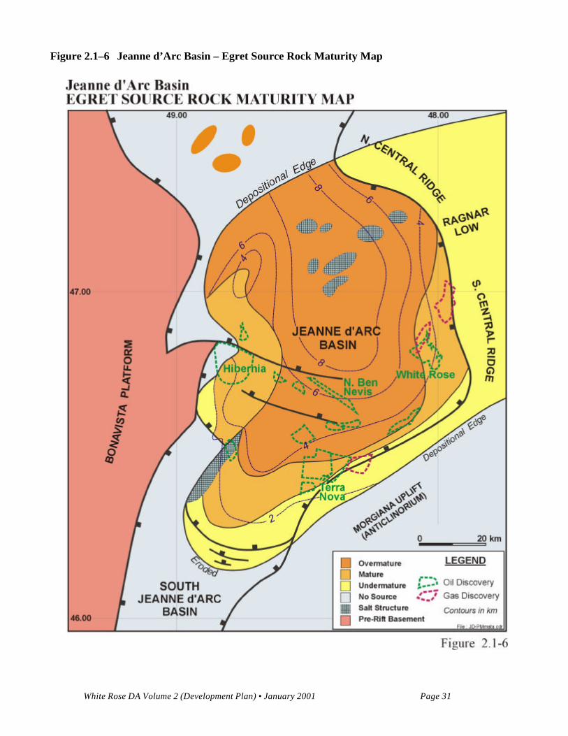
The Jeanne d’Arc Basin is unique amongst East Coast basins in that it is a proven oil province containinglarge oil and gas fields. The rich oil-prone Kimmeridgian Egret Member source rock (Figure 2.1-6), theprincipal proven source (Fowler and McAlpine 1994), is similar in age and quality to the prolific UpperJurassic Kimmeridge Clay Formation of the North Sea. The Egret Member is widespread in the Jeanned’Arc Basin, and has been penetrated in three White Rose area wells: White Rose A-90, Archer K-19and Trave E-87. Three additional potential source intervals occur sporadically throughout the basin,within the Jeanne d’Arc Formation, Lower Rankin Formation and Voyager Formation, but are notbelieved to be substantial hydrocarbon generators (Fowler and Brooks 1990).
The Egret Member is found near the top of the Rankin Formation, and consists of marls and organic-richlaminated shales (up to 8 percent total organic carbon (TOC)). These shales were deposited duringhighstand cycles, allowing the concentration of organic rich debris in deep silled basins (Powell 1985).The unconformable contacts bounding the Rankin Formation likely indicate tectonic formation of thepaleotopography necessary for a stratified water column, and the concentration and preservation oforganic material. The Egret Member was deposited over a large area, likely in a series of interconnectedbasins, but has since been largely eroded to the south of the Jeanne d’Arc Basin in the Horseshoe andWhale Basins.
The present day maturity pattern of the Egret was likely well established by the Late Cretaceous, due torapid subsidence and high sedimentation rates during the Early Cretaceous. The maturity modelling workof Williamson (1992) indicates that the Egret began to generate oil in the deepest, central, Jeanne d’ArcBasin area at this time, with the mature/non-mature boundary moving progressively towards the basin’smargins during the Tertiary. With the onset of maturity, hydrocarbon migration would have begun, withevidence for both vertical and lateral migration in the basin.
Current maturity values, as modelled, indicate that the source rocks are overmature in the central Jeanned’Arc, generating only gas (Figure 2.1-6). Early mature source rocks are still present on the eastern andsouthern flanks of the basin, and have been penetrated at Terra Nova and White Rose (Fowler andSnowden 1989).
White Rose DA Volume 2 (Development Plan) • January 2001 Page 31
Figure 2.1–6 Jeanne d’Arc Basin – Egret Source Rock Maturity Map
White Rose DA Volume 2 (Development Plan) • January 2001 Page 32
2.1.2 White Rose Field General
The White Rose Field is a highly faulted complex of rotated fault blocks, cored by salt at depth. WhiteRose is bounded to the north and west by basinward-dipping flanks of the White Rose salt dome. Theeastern margin of the structure abuts against the basin-bounding Voyager Fault, while the southernboundary of the field encompasses the White Rose Terrace. The Terrace is bounded by major faults at itswestern, eastern, and probably, southern limits (Figure 2.1-5).
The principal reservoir is the Aptian Avalon Formation, which consists of fine to very fine grainedquartzose sandstones deposited in a shallow marine to shoreface setting. As of April 2000, the field hadbeen delineated by nine wells. Pressure measurements and fluid contracts indicates that the Avalonreservoir is divided into three separate pools. The West Avalon Pool has been penetrated by one well, J-49. The North Avalon Pool has been penetrated by two wells, N-22 and N-30. The most significantpool, South Avalon, has 350 m of sandstone with over 100 m of net oil pay. Four wells have penetratedthe Avalon Formation in this most southerly pool. They are White Rose E-09, L-08, A-17 and H-20.The A-90 well did not penetrate the reservoir section, but helps define the eastern extent of the field. TheL-61 well tested gas from the Paleocene South Mara Member sandstone, however the Avalon Formationwas not well developed and tested a small amount of water and gas. The Hibernia Formation sandstoneshave tested small amounts of oil and gas from overpressured lower quality shaly sandstones in N-22 andE-09. Oil was also recovered from a Jurassic overpressured zone at the base of E-09 (TempestSandstone?). Analysis of the results of the H-20 well drilled in 2000 are currently ongoing.
This section is organized into the following:
• White Rose Stratigraphy;• White Rose Structural Geology;• White Rose Geochemistry; and• Description of Reservoir Stratigraphy and Facies Interpretation.
2.1.2.1 White Rose Stratigraphy
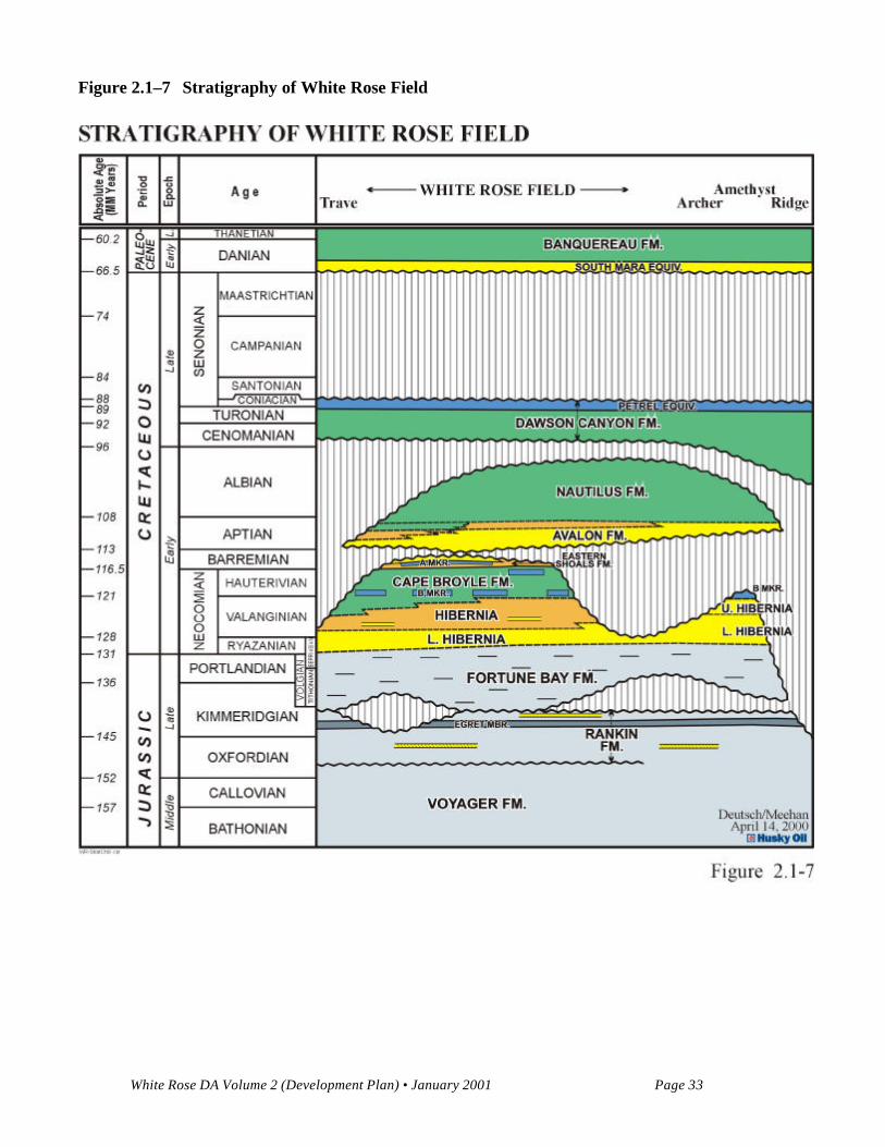
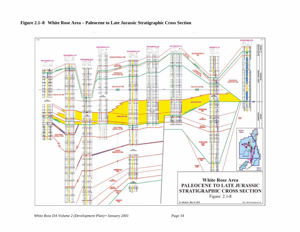
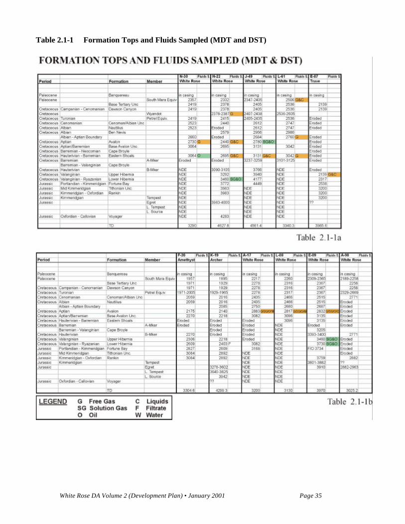
The stratigraphic section penetrated by the wells drilled in the White Rose region contains Tertiary toUpper Jurassic rocks (Figures 2.1-7 and 2.1-8). Of the formations penetrated, the South Mara, Avalon,Eastern Shoals and Hibernia sections have reservoir quality sandstones. The following paragraphsreview the stratigraphy of the Late Jurassic to Tertiary as seen in the White Rose region, beginning withthe oldest formation penetrated. The Aptian Avalon Formation, the most economically significantformation will be discussed in more detail in the Stratigraphy and Depositional Environments subsection.The formations penetrated and fluids sampled in the White Rose Field and area are outlined in Table 2.1-1a and 2.1-1b.
White Rose DA Volume 2 (Development Plan) • January 2001 Page 33
Figure 2.1–7 Stratigraphy of White Rose Field
White Rose DA Volume 2 (Development Plan) • January 2001 Page 34
Figure 2.1–8 White Rose Area – Paleocene to Late Jurassic Stratigraphic Cross Section
White Rose DA Volume 2 (Development Plan) • January 2001 Page 35
Table 2.1-1 Formation Tops and Fluids Sampled (MDT and DST)
White Rose DA Volume 2 (Development Plan) • January 2001 Page 36
The oldest rocks penetrated in the White Rose region are from the Voyager Formation in the White RoseN-22 well. The Upper to Middle Jurassic Voyager Formation is Bathonian to Oxfordian in age.Although the full section was not penetrated, it is composed primarily of grey, dolomitic to calcareousshales and siltstones.
Unconformably overlying the Voyager Formation is the Rankin Formation containing the Egret Membersource rock and the Tempest Member sandstones. The Rankin Formation is Oxfordian to Kimmeridgianin age, and consists of a mixture of shales and siltstones with minor limestones and sandstones. TheEgret member, the main source rock for the hydrocarbons in the White Rose area, has been penetrated inthe A-90 well and consists of organic rich grey calcareous shales and marls. Although a similar agedsection was penetrated towards the base of the White Rose N-22 and E-09 wells, the Egret Member wasnot encountered. Oil bearing, overpressured sandstones, probably the Tempest Member were penetratedin the E-09 well.
The Jeanne d’Arc Formation has shaled out in the White Rose area, and its stratigraphic equivalent in theFortune Bay Formation is organic rich and is found in the Archer K-19 and Trave E-87 wells. TheKimmeridgian to Portlandian aged Fortune Bay Formation has been penetrated in White Rose N-22 andJ-49 and at the bottom of the A-17 well where it unconformably overlies the Rankin Formation. TheFortune Bay Formation is comprised predominantly of grey, silty marine shales deposited as part of amajor transgression in the Late Jurassic.
The oldest Cretaceous aged rocks encountered in the White Rose area form part of the Ryazanian toValanginian age Hibernia Formation. The Hibernia Formation has been penetrated in the White Rose A-17, E-09, N-22 and J-49 wells. The Hibernia sandstones form a regressive succession which can beseparated into an upper and lower member, with a distinctive basal unit. The upper Hibernia Member isnot well developed in the White Rose area and consists of poor quality siltstones and shales with onlyminor sandstones. The upper Hibernia decreases in quality and thickness to the north through the field.
The lower Hibernia Member has been penetrated in the E-09 and N-22 wells where thin shaly marinesandstones contained small amounts of oil. The lower Hibernia Member consists of fine to mediumgrained, light grey/brown and slightly silty sandstones. It was deposited primarily as a progradingshoreface succession as part of an overall regional regressive package. The shoreface succession containsminor fluvial and marginal marine deposits. The gross sandstone thickness varies from 272 m in WhiteRose J-49 where it is poorly developed, to only 86 m in the A-17 well where it has been largely eroded.
Hibernia Formation deposition is followed by a regional transgressive package of marine shales. TheNeocomian to Barremian Cape Broyle Formation in the White Rose area is dominated by marine shaleswith minor siltstones. The B Marker, a shelly limestone which is regionally correlative through much ofthe Jeanne d’Arc Basin, is thin and poorly developed at White Rose. Although present in White Rose N-22 and E-09, no correlative limestone interval is observed in J-49, probably because of a deeper
White Rose DA Volume 2 (Development Plan) • January 2001 Page 37
depositional environment. It is eroded in the Archer K-19, White Rose A-17 and the Trave E-87 wells.No reservoir quality rocks or hydrocarbon shows have been seen in the Cape Broyle Formation in theWhite Rose area.
The Hauterivian to Barremian Eastern Shoals Formation unconformably underlies the Avalon Formationthroughout much of the White Rose Field. The White Rose E-09, L-08, N-30, N-22, L-61 and J-49 wellsall penetrate the Eastern Shoals directly below the Avalon Formation. In the E-09 and L-08 wells theEastern Shoals is largely eroded, leaving only a 60 m thick limestone, while in the N-30, N-22 and J-49wells, it is comprised of interbedded shale, siltstone and sandstone. The A Marker, a shelly limestonewithin the Eastern Shoals Formation, is preserved in the J-49 and L-61 wells. The Eastern ShoalsFormation has been eroded in the White Rose A-17 and A-90, and the Trave E-87 wells.
The Aptian aged Avalon Formation is the primary reservoir in the White Rose Field. The AvalonFormation will be covered in significant detail in following subsections. In general, the Avalon is amarginal marine, shoreface succession through much of the field. The Avalon is dominated by very fineto fine grained sandstones, siltstones and shales, and ranges from 0 to 400 m in thickness. The mainsandstone accumulations occur in the southeastern portion of the field with the E-09, L-08 and A-17wells (South Avalon Pool) exhibiting thicknesses of up to 350 m of sandstone. The Avalon Formation isabsent in the White Rose A-90 and Trave E-87 wells.
The Nautilus Formation is primarily Albian in age and is present in all the wells in White Rose, althoughnot to the north in the Trave E-87 well. The Nautilus Formation conformably overlies the AvalonFormation, and is laterally equivalent where the Avalon Formation shales out. It represents a regionaltransgressive event, reaching up to 350 m in the A-17 well. The Nautilus Formation is comprised of greysiltstones and shales with very minor sandstones. No reservoir quality rocks are present in the NautiliusFormation in the White Rose Field.
Unconformably overlying the Nautilius Formation is the Cenomanian to Coniacian aged Dawson CanyonFormation which consists primarily of marls and calcareous shales. The Dawson Canyon Formationranges in thickness from 100 to 500 m in the White Rose Field. The Petrel Member is present at the topof the Dawson Canyon Formation in the White Rose area, except where eroded in the vicinity of the A-17well. It consists of a thin light grey to brown argillaceous limestone.
The Banquereau Formation in the White Rose Field is composed of Tertiary clastics deposited duringthermal subsidence. The Banquereau Formation is a thick shale succession (up to 2500 m) with coarserclastics at the base. The South Mara Member sandstone is occasionally present at the base of theBanquereau, directly overlying the Base Tertiary Unconformity. More often a sandy siltstone is present.
White Rose DA Volume 2 (Development Plan) • January 2001 Page 38
A sandstone from this zone tested gas and condensate in the White Rose L-61 well. In L-61, the SouthMara Member is a 30 m section of brown, glauconitic silty fine to very fine grained sandstones The basalnet porous sandstone is 5 m thick.
2.1.2.2 White Rose Structural Geology
Three episodes of rifting affected the White Rose area. During the first rifting phase, thick Osprey/Argosalt beds were deposited. This salt was tectonically mobilized during the second rifting stage formingelongated salt walls parallel with the emerging Central Ridge. The Central Ridge was formed in thefootwall of the Voyager Fault Zone. Major north-south and northeast-southwest faults dissect thesediments deposited above the northerly plunging salt wall, including the source rocks. The third riftingstage had a pronounced influence on the area as the salt ridge was divided by salt withdrawal into a majorridge (Amethyst) and a northerly circular diapir (White Rose). A fault fan, creating numerous rotatedfault blocks occupies the saddle zone between these salt features. In the southeastern White Rose area,imbricates of the Voyager Fault created low blocks and terraces where the Avalon Formation wasdeposited, and high blocks that were subjected to erosion. Toward the end of the extensional stage, twomajor salt withdrawal synclines in the area, Trave and Grand Bruit, were formed. The crestal areas ofboth Amethyst Ridge and White Rose Diapir were elevated by salt and repeatedly subjected to erosion.The existence of Avalon Formation in these areas is difficult to prove by seismic correlation alone. Withthe exception of the Amethyst Ridge and the northern diapir, only minor salt movements occurred duringlatest Cretaceous and Early Tertiary in the White Rose area.
As no extensional stage seismic marker is continuous over the entire White Rose area to allow consistentstructural time mapping, a complex depositional (in the west)/erosional (in the east) surface at the base ofthe Avalon Formation was interpreted for structural and tectonic characterization of the field. Theseismic interpretation was completed on every line, cross-line and selected dip lines using a CompositeRegional Marker (Figure 2.1-5) that varies from A Marker in the west, to Base Avalon and BaseReservoir in the central area. The mid-Kimmeridgian Unconformity to Base Tertiary Unconformitymarkers were mapped in the eastern portion of the White Rose area.
Time structure on the Composite Seismic Marker shows the main structural elements of the White Rosearea (Figure 2.1-5).
a. high areas: the Amethyst Ridge in the south, the White Rose Diapir in the north, and the rotatedblocks adjacent to Voyager Fault Zone;
b. low areas: the Trave Syncline in the northeast and the Grand Bruit Low representing thesoutheastern tip of the basin depocenter;
White Rose DA Volume 2 (Development Plan) • January 2001 Page 39
c. intermediate elevated areas: the Terrace (A-17) block, the L-08 and E-09 blocks, the centralblocks elongated in a north-south direction and the North Trepassey Depression and the numerousblocks on the fringe of the White Rose diapir;
d. complexly faulted area: the collapse zone and northwest-southeast trending fault fan north ofAmethyst ridge; the intensely faulted southwestern flank of the White Rose diapir dissected bynumerous northeast-southwest trending faults; the collapse zone on the western side of the WhiteRose diapir and the collapse zone east of the N-22 well.
The White Rose area abuts the Voyager Fault, a very complex zone of fault imbrication and ramping,bordering the Central Ridge. The Amethyst salt cored ridge and White Rose Diapir once formed acontinuous salt cored high in front of the Voyager Fault Zone. Between these two structural features, saltwithdrawal, initiated during Aptian and culminating in the Albian, caused a central collapse zone nowoccupied by a westerly dipping extensional fault fan. In some areas, the Cretaceous structural elevationrelationships have been reversed due to post-Aptian salt movement. Thus, the seismically mappedAvalon Formation abnormally thickens toward the north and west, having the thickest interval in therotated blocks, just east of the Central Fault.
Three intersecting fault systems oriented northeast-southwest, north-northwest south-southwest andnorth-south, compartmentalize the area. As indicated by reservoir pressure data, a few major faults (forexample, West Amethyst, Central, Twin faults) together with a low structural trend oriented north-northeast south-southwest segment the area into three pools (Figure 2.1-5):
1. The South Avalon Pool (E-09, L-08, A-17 and environs);
2. The West Avalon Pool (J-49 field and environs) and
3. The North Avalon Pool (N-30, N-22 and environs).
Structurally, the White Rose pools reside in a complexly faulted area located on the hangingwall of theVoyager Fault Zone and are situated above the deep-seated Amethyst salt ridge and White Rose diapir(Figure 2.1-4 and 2.1-5). These three pools are associated with the White Rose Complex and are outlinedin four schematic structural cross-sections, generated from seismic data across the field (Figures 2.1-9and 2.1-10).
White Rose DA Volume 2 (Development Plan) • January 2001 Page 40
Figure 2.1–9 White Rose Area – Structural Cross Sections C-C’ and D-D’
White Rose DA Volume 2 (Development Plan) • January 2001 Page 41
Figure 2.1–10 White Rose Area – Structural Cross Sections A-A’ and B-B’
White Rose DA Volume 2 (Development Plan) • January 2001 Page 42
South Avalon Pool
The South Avalon Pool occupies an area of approximately 18 km², located east of the Amethyst Ridgeand Central Fault and includes the E-09, L-08, A-17 wells (Figures 2.1-5, 2.1-9 and 2.1-10 Section A-A’). The pool is geologically complicated; the trap is structural, but may have a significant stratigraphiccomponent. The trap is a collection of three- and four-way fault closed blocks and possible stratigraphiccomponents toward the south and east. This pool is limited by the East Amethyst, Central and Twinfaults to the west, and by structural dip toward the north and east. At the southernmost tip of the Terrace,the Avalon reservoir either thins out, onlapping the mid-Kimmeridgian unconformity or is faulted downto the north. Poor seismic data in this area precludes a definite understanding of the southern boundary.
With the exception of the Terrace, the larger blocks are tilted eastward and bounded by westerly dippingfaults. Structural dip outside the Terrace varies from 7° to 12° east. The reservoir is cut by major andsecondary non-sealing faults of variable throw oriented northeast-southwest. Major faults, such as theAmethyst Fault and Central Fault have a vertical throw of 500 m and 300 m and dips of 45° east and 28°west, respectively. The sandstone reservoir is in communication across the North Terrace and North E-09 faults, as shown by minimal change of fluid contact levels in the delineation wells (Section 2.2, Figure2.2-15). Minor faults (throw less than 30 m) were carefully mapped or extracted from derivative maps inorder to assess the structural complexity within the pay zone.
Most of the faults offset both Top and Base of the Avalon Formation and continue at depth beyond themid-Kimmeridgian unconformity. Several secondary faults affect only the top or the base of thereservoir. All minor faults having vertical throws as low as 30 to 20 m, are seismically mapped (Figure2.1-5), while smaller ones are identified as trends on the gradient maps and coherency displays (refer toSection 2.2).
No clear flat events are observed on the seismic data that might be associated with fluid contacts,although AVO modelling indicates flat spots should exist. The lack of flat events may be due to highbackground noise and severe demultiple routines applied to the data.
West Avalon Pool
The West Avalon Pool, which includes the J-49 well, encompasses a 16-km² area and is confinedbetween the West Amethyst, Central and North J-49 faults and the crestal erosional edge. Structurally,the West Avalon Pool occupies the central collapse area between the northern plunge of the AmethystRidge and the southern part of the White Rose Diapir (Figure 2.1-5). The trap is structural and thereservoir consists of a thinner sequence of Avalon Formation than the sequence drilled in the SouthAvalon Pool (Figures 2.1-9 Section C – C’ and 2.1-10 Section B – B’). Elongated faults of variablethrow, dissect the area into many thin blocks, oriented northwest-southeast. The Base of Avalon in thisarea does not coincide with the mapped A Marker since erosional incision here is not as significant. Two
White Rose DA Volume 2 (Development Plan) • January 2001 Page 43
highly complex areas that are poorly imaged by seismic data are located in the downthrown side of theCentral Fault separating the South and West Avalon Pools and just north of the Amethyst Ridge. Acentral low trend lies between the area adjacent to the J-49 well and the area immediately north of theAmethyst Ridge.
In general, the easternmost faults have larger throws. The highest part of the pool is the northern portionwhere Avalon beds are gently dipping toward the southeast. However, dense north-south faults affectthis part of the pool. The eastern blocks dip toward the southeast at about 8 to 10°. The block-boundingfaults dip towards southwest at 30 to 38°. The western part of the pool represents the portion of theunderlying Amethyst salt ridge that is unaffected by crestal collapse. It plunges, initially at 8°, and thensteeper, at 14° toward the Grand Bruit Syncline. Conjugate, northeast-southwest, small faults of 20 to 30m are mapped around the J-49 location (Figure 2.1-5).
North Avalon Pool
The North Avalon Pool includes the N-22 and N-30 wells and occupies an area of about 10 km². It isbounded by the Central Fault, White Rose Diapir erosional edge, Trave Fault and southeastern end of theTrave Syncline (Figure 2.1-5). The North Avalon Pool is located on the southeastern flank of the WhiteRose Diapir. The area is dissected by numerous faults trending mainly north-northwest south-southeastand north-northeast south-southwest. Two major faults bound the N-22 block. The first fault dips to thewest at 40° and the second fault to the east at approximately 50° (Section 2.2, Figure 2.2-12). Thestructural dip on this block is 7° southeast. Two other major faults, the Central and Twin faults, boundthe N-30 blocks. Another important fault forms a rotated block on the western flank of the Travesyncline. This fault dips to the northwest at approximately 20°.
The trap is structural for the area tested by the N-22 and N-30, but a stratigraphic component may existtoward the northwest, where the Avalon sandstone may be absent due to truncation or onlap. As the areais generally higher than the rest of the White Rose Complex, the Avalon Formation appears to thin overthe top of the White Rose Diapir and is completely missing on its crest (Figure 2.1-5 and Section 2.2,Figure 2.2-12).
The northwestern part of the White Rose Complex is cut by a series of radial faults oriented northeast-southwest and by minor intersecting faults, part of a swarm parallel to the crestal zone. Numerous smallfault blocks are formed and occupy this side of the White Rose Diapir. One of these blocks was tested bythe L-61 well. The crestal zone of the White Rose Diapir trends approximately north-south. Anintensively faulted high block marks the higher part of the deep-seated salt diapir. Mapping the baseAvalon marker in this area is difficult as the crest is dissected by several faults having opposing dips.
White Rose DA Volume 2 (Development Plan) • January 2001 Page 44
Structure of the mid-Kimmeridgian Unconformity. The mid-Kimmeridgian unconformity corresponds tothe Top of the Rankin Formation, which includes the Egret Member oil source rock and correlates to astrong amplitude reflector at Archer K-19, White Rose N-22 and A-90 and immediately below the WhiteRose A-17 well (Figure 2.1-11). This mid-Kimmeridgian unconformity is situated immediately under thereservoir on the Terrace and North Trepassey areas, is faulted down to 800 m in the central area andabruptly rises on the eastern side where it lies under Albian shaly carbonates (Nautilus Formation). TheEgret source rock, if preserved, is also high in a local horst located west of the N-22. The structural lows,Grand Bruit, Trave and South Badger form veritable hydrocarbon kitchens and are extensively faulted atthe Rankin marker level. These 30 - 40° dipping faults form excellent migration conduits.
Over the greater White Rose area the source rock is structurally bounded by major faults, coinciding tothe three distinct pools and their hydrodynamic systems (South, North and West Avalon Pools,respectively) (Figure 2.1-5 and Section 4.5, Figures 4.5-1 and 4.5-2 Pressure Profiles in ReservoirEngineering).
In conclusion, three separate structural areas have been delineated within the White Rose Complexcorresponding to three distinct oil accumulations: South Avalon Pool, West Avalon Pool and NorthAvalon Pool. They were identified in the White Rose area, by drilling a series of exploration anddelineation wells and by interpreting structural and tectonic maps of two seismic horizons: 1. TheComposite Marker map (Figure 2.1-5) and 2. mid-Kimmeridgian Unconformity map (Figure 2.1-11).These pools have a complicated structural trapping mechanism and a stratigraphic component toward thesouthern and northern part of the White Rose Complex.

White Rose DA Volume 2 (Development Plan) • January 2001 Page 45
Figure 2.1–11 White Rose Complex – Mid-Kimmerindgian Unc. Time Structure
White Rose DA Volume 2 (Development Plan) • January 2001 Page 46
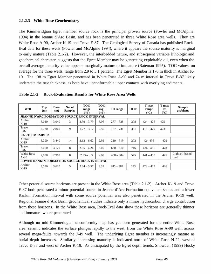
2.1.2.3 White Rose Geochemistry
The Kimmeridgian Egret member source rock is the principal proven source (Fowler and McAlpine,1994) in the Jeanne d’Arc Basin, and has been penetrated in three White Rose area wells. They areWhite Rose A-90, Archer K-19 and Trave E-87. The Geological Survey of Canada has published Rock-Eval data for these wells (Fowler and McAlpine 1994), where it appears the source maturity is marginalto early mature (Table 2.1-2). However, the interbedded nature, and subsequent variable lithologic andgeochemical character, suggests that the Egret Member may be generating exploitable oil, even when theoverall average maturity value appears marginally mature to immature (Bateman 1995). TOC values, onaverage for the three wells, range from 2.9 to 3.1 percent. The Egret Member is 170 m thick in Archer K-19. The 138 m Egret Member penetrated in White Rose A-90 and 74 m interval in Trave E-87 likelyunderstate the true thickness, as both have unconformable upper contacts with overlying sediments.
Table 2.1-2 Rock-Evaluation Results for White Rose Area Wells
WellTop(m)
Base(m)
No. ofSamples
TOCrange(%)
TOCavg(%)
HI range HI av.T maxrange(ºC)
T maxav.
(ºC)
Sampleproblems
JEANNE D’ARC FORMATION SOURCE ROCK INTERVALArcherK-19
3,020 3,040 3 2.59 – 3.79 3.06 277 – 328 308 424 – 426 425
TraveE-87
2,720 2,840 9 1.27 – 3.12 2.56 137 – 731 381 419 – 429 423
EGRET MEMBERArcherK-19 3,290 3,440 14 2.13 – 6.62 2.92 210 – 519 273 424-436 429
TraveE-87
3,050 3,120 8 2.35 – 4.24 3.05 680 – 810 746 426 - 431 428
White RoseA-90
2,890 2,960 8 2.33 – 3.3 2.88 450 – 604 545 441 – 450 445 Light oil-basedmud
LOWER RANKIN FORMATION SOURCE ROCK INTERVALArcherK-19
3,570 3,620 5 2.84 – 3.57 3.33 285 – 387 333 424 – 427 426
Other potential source horizons are present in the White Rose area (Table 2.1-2). Archer K-19 and TraveE-87 both penetrated a minor potential source in Jeanne d’Arc Formation equivalent shales and a lowerRankin Formation interval with some source potential was also penetrated in the Archer K-19 well.Regional Jeanne d’Arc Basin geochemical studies indicate only a minor hydrocarbon charge contributionfrom these horizons. In the White Rose area, Rock-Eval data show these horizons are generally thinnerand immature where penetrated.
Although no mid-Kimmeridgian unconformity map has yet been generated for the entire White Rosearea, seismic indicates the surface plunges rapidly to the west, from the White Rose A-90 well, acrossseveral mega-faults, towards the J-49 well. The underlying Egret member is increasingly mature asburial depth increases. Similarly, increasing maturity is indicated north of White Rose N-22, west ofTrave E-87 and west of Archer K-19. As anticipated by the Egret depth trends, Snowden (1999) Husky
White Rose DA Volume 2 (Development Plan) • January 2001 Page 47
Consultant Report, in a White Rose reservoir compartmentalization study, found the biomarker ratios forWhite Rose J-49, N-22 and L-61 oils higher maturity than those from the South Avalon Pool. He alsolooked at the geochemical properties of all available White Rose oils and condensates and suggested thatthe two geochemical signatures are from the same Egret source, but likely from two different kitchenareas; one of which charged J-49.
The extensive faulting present in the White Rose area can be used to argue that vertical charging of thereservoirs was the dominant migration mechanism, in addition to the fact that at least three separate poolsare present within the Avalon Formation reservoir. Alternatively, lateral migration can be postulatedbecause of the thick, widespread Avalon sandstone. Lateral migration helps to explain the large gas capover the prominent North Avalon Pool, since an overmature source is laterally accessible to thenorthwest. Lateral migration is also evident in the Trave E-78 well. The gas/condensate reservoir fluid,indicative of highly mature source rock conditions, could not have migrated vertically from themarginally mature Egret Member penetrated in the well. Although there is evidence to support bothvertical and lateral migration, deciphering this complex history will await the acquisition and integrationof additional data as more wells are drilled.
2.1.2.4 Description of Reservoir Stratigraphy and Facies Interpretation
The Avalon Formation (Aptian) has been modelled using three principal reservoir layers in the SouthAvalon Pool and two principal reservoir layers in the West Avalon and North Avalon Pools.
Petrographic, petrophysical, sedimentological, dipmeter/FMI, production test and seismic data were usedto define the stratigraphic framework and develop a depositional model for the White Rose Field.
The section includes:
• main reservoir and non-reservoir lithofacies and facies;• general facies associations;
• paleogeography;• reservoir modelling facies;• local tectonic features and influence on the reservoir; and• geometry and stacking pattern of the reservoir layers and facies.
Main Reservoir and Non-Reservoir Lithofacies and Facies
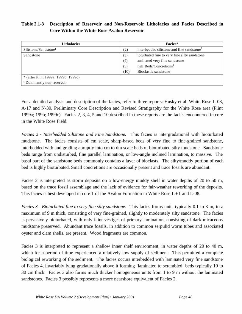
Two main lithofacies; sandstone and siltstone/sandstone, were identified from an analysis of 467 m ofcore recovered from five wells in the field. The two lithofacies were further subdivided into reservoir andnon-reservoir facies, as outlined in the table below (Table 2.1-3). A description and interpretation of theindividual facies is provided in the following subsection.
White Rose DA Volume 2 (Development Plan) • January 2001 Page 48
Table 2.1-3 Description of Reservoir and Non-Reservoir Lithofacies and Facies Described in
Core Within the White Rose Avalon Reservoir
Lithofacies Facies*
Siltstone/Sandstone¹ (2) interbedded siltstone and fine sandstone1
Sandstone (3) ioturbated fine to very fine silty sandstone(4) aminated very fine sandstone(5) hell Beds/Concretions1
(10) Bioclastic sandstone* (after Plint 1999a; 1999b; 1999c)¹ Dominantly non-reservoir
For a detailed analysis and description of the facies, refer to three reports: Husky et al. White Rose L-08,A-17 and N-30, Preliminary Core Description and Revised Stratigraphy for the White Rose area (Plint1999a; 199b; 1999c). Facies 2, 3, 4, 5 and 10 described in these reports are the facies encountered in corein the White Rose Field.
Facies 2 - Interbedded Siltstone and Fine Sandstone. This facies is intergradational with bioturbatedmudstone. The facies consists of cm scale, sharp-based beds of very fine to fine-grained sandstone,interbedded with and grading abruptly into cm to dm scale beds of bioturbated silty mudstone. Sandstonebeds range from undisturbed, fine parallel lamination, or low-angle inclined lamination, to massive. Thebasal part of the sandstone beds commonly contains a layer of bioclasts. The silty/muddy portion of eachbed is highly bioturbated. Small concretions are occasionally present and trace fossils are abundant.
Facies 2 is interpreted as storm deposits on a low-energy muddy shelf in water depths of 20 to 50 m,based on the trace fossil assemblage and the lack of evidence for fair-weather reworking of the deposits.This facies is best developed in core 1 of the Avalon Formation in White Rose L-61 and L-08.
Facies 3 - Bioturbated fine to very fine silty sandstone. This facies forms units typically 0.1 to 3 m, to amaximum of 9 m thick, consisting of very fine-grained, slightly to moderately silty sandstone. The faciesis pervasively bioturbated, with only faint vestiges of primary lamination, consisting of dark micaceousmudstone preserved. Abundant trace fossils, in addition to common serpulid worm tubes and associatedoyster and clam shells, are present. Wood fragments are common.
Facies 3 is interpreted to represent a shallow inner shelf environment, in water depths of 20 to 40 m,which for a period of time experienced a relatively low supply of sediment. This permitted a completebiological reworking of the sediment. The facies occurs interbedded with laminated very fine sandstoneof Facies 4, invariably lying gradationally above it forming ‘laminated to scrambled’ beds typically 10 to30 cm thick. Facies 3 also forms much thicker homogeneous units from 1 to 9 m without the laminatedsandstones. Facies 3 possibly represents a more nearshore equivalent of Facies 2.
White Rose DA Volume 2 (Development Plan) • January 2001 Page 49
The facies constitutes a very small portion (less than 5 percent) of the total reservoir in the South AvalonPool but may include as much as 50 percent of the gross reservoir facies in the West and North AvalonPools.
Facies 4 - Laminated very fine sandstone. This facies consists of very fine grained (very fine upper)clean, well sorted sandstone ranging in thickness from about 20 cm to 1 m thick, deposited in less than 20m of water. Individual beds, up to 4 m in thickness, have been observed and may represent singledepositional units. However, amalgamated beds, separated by subtle erosion surfaces, are common. Thesandstones generally show a fine, mm to cm scale parallel to low-angle (typically < 10º), planer to gentlycurved lamination. Occasionally the beds are massive. The laminated sandstones are interbedded withbioturbated silty sandstone of Facies 3 and shell beds of Facies 5. Burrows are neither significantly largeor abundant.
Facies 4 is interpreted to represent deposition in a shoreface setting during intense storms when planebed, swaley bedforms or massive beds developed. Recognition of beach/foreshore deposits in this unit isdifficult because of the uniform and very fine grain size of the sand. Individual laminated sandstone unitsmay represent a single or possibly amalgamated storm event. The absence of mud laminae in Facies 4suggests that deposition took place in an environment in which all traces of mud, deposited during fairweather, was removed by storms. Facies 4 is genetically related to the shell beds discussed below.
The laminated very fine sandstone facies make up approximately 90 percent of the reservoir in WhiteRose A-17 and L-08 and one-half of the total cored reservoir interval in White Rose N-30.
Facies 5 - Shell Beds/Concretions. This facies consists principally of serpulid worm tubes and variousspecies of bivalves, including several species of oysters. Rare brachiopod, belemnite guards and rareechinoderm plates are also present. Shell debris is generally dispersed through a matrix of very fine sandbut is occasionally clast-supported. The facies ranges in thickness from one shell thick (that is, < 5 mm)but is typically 5 to 30 cm thick and is generally cemented with calcite.
Concretions, which represent the most significant diagenetic facies encountered in the White Rose core,are invariably associated with shell beds. In most cases, concretions appear to have nucleated on shellbeds. The concretions range in thickness from a few centimetres to a maximum of 2.8 m. Calcite cementcommonly extends several decimetres above and below the shell beds, sometimes resulting in severalshell beds being incorporated into one large concretion. It is postulated that much of the cement in theconcretions was provided by the dissolution of aragonite shells dispersed throughout the cored interval.Concretions have sharp boundaries with uncemented sandstone and are easily recognizable on the FMIlog. Many show converging upper and lower boundaries and are interpreted as highly lenticular ratherthan laterally-continuous cemented intervals.
White Rose DA Volume 2 (Development Plan) • January 2001 Page 50
The shell beds of Facies 5 are interpreted as a basal lag and are overlain by the genetically relatedlaminated to massive shoreface sandstones of Facies 4. Each package is interpreted to represent a majorstorm event.
Shell beds make up approximately 8 percent of the cored interval in White Rose L-08 and A-17 but lessthan 2 percent of the cored interval in N-30. Concretionary zones constitute approximately 15 percent ofthe cored interval in White Rose A-17, L-08 and N-30.
Facies 10 - Bioclastic Sandstone. This facies consists of medium- to very coarse-grained shell hash thatincludes numerous coarser bioclasts and other pebbles, set in a matrix of very fine-grained quartzosesandstone. Bioclasts include oysters, belemite guards, serpulid worm tubes and the coral Thamnasteria.The facies is crudely stratified at an angle of about 20º to massive. Burrows are common.
The bioclastic sandstone facies is interpreted as a transgressive deposit that accumulated on the EasternShoals Formation by marine erosion associated with the basal Avalon transgression. The faciesconstitutes a very minor part of the N-30 core but is significant in that it is the only example of basalAvalon Formation cored in the White Rose Field.
General Facies Associations
There is no clear organization of vertical facies within the White Rose core. However, the repetitiveerosive-based, laminated sandstone, sometimes marked by a shell lag, grading up into bioturbated siltysandstone indicates a genetic relationship between Facies 3, 4 and 5. These facies are interpreted asclassic examples of laminated to scrambled storm beds. The rising phase of the storm is represented byan eroded surface, cutting into the laminated or bioturbated sandstone of the underlying unit. The waningphase of the storm is represented, first by a lag of bioclasts (shells/shell bed-Facies 5) or mud pebbleseroded from the sea floor, overlain by several decimetres of laminated, very fine sandstone (Facies 4)deposited by high velocity currents generated by storm waves. The bulk of the lamination is horizontal,indicating that upper-plane bed conditions prevailed at most times. The upper bioturbated part (Facies 3)of many beds represents a protracted period which records the recolonization of the sea floor byburrowing organisms and epifauna which progressively destratified the upper portion of the storm bed.Mud was probably introduced into the sediments as faecal pellets and from background settling ofsuspended material. The sharp-based storm beds of Facies 2 may represent a slightly more distalequivalent of Facies 3, deposited where silt was slightly better able to accumulate. Finally Facies 10,dominantly of biogenic origin, accumulated on a rocky sea floor cut into the Eastern Shoals Formationabove the basal Avalon unconformity as a transgressive deposit and forms the base of the reservoirsequence.
White Rose DA Volume 2 (Development Plan) • January 2001 Page 51
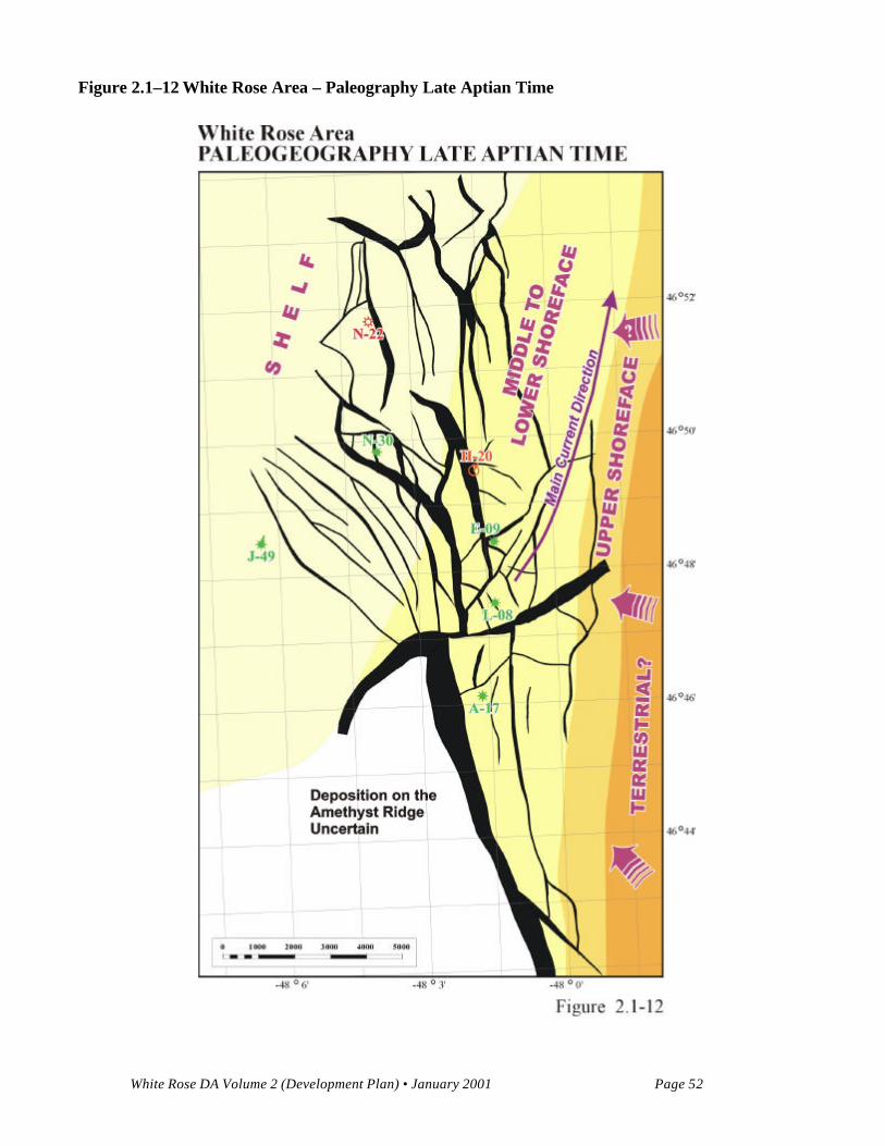
Paleogeography
During the time of deposition of the main sandstone package of the Avalon Formation, a period ofrelative stillstand or aggradation occurred where subsidence rates kept up with depositional rates. Thethick sandstone sequences seen in the E-09, L-08 and A-17 wells suggest continuous deposition in alower to middle shoreface environment with no significant breaks indicated. The inferredpaleogeography during this time is illustrated in Figure 2.1-12. The shoreline appears to have trended ina south southwest to north north-east orientation with the more distal, offshore deposits to the northwestof this trend. The sources for the sediment would have been predominantly to the southeast, whereerosion of the Central Ridge was taking place. Sediments sourced to the shoreline were then distributedby currents moving northward along the shoreline. The sequences within the J-49, N-30 and N-22 wellsconfirm this orientation with more distal deposits of bioturbated mudstones and siltstones and muchthinner sandstone sections. No wells have been drilled to the southeast of the shoreline trend, and nosediments deposited above the middle shoreface have been encountered to date.
Reservoir Modelling Facies
The Aptian aged Avalon Formation is the main reservoir in the White Rose Field. The Avalon Formationconsists of sandstones, siltstones and shales with calcite concretions which have developed fromavailable bioclastic material. The Avalon is an aggradational fining upwards succession comprised ofshoreface sands. In all wells in the field, the higher quality and percentage of sandstone occurs at or nearthe base of the Avalon, with the amount and quality of sandstone decreasing upwards. The thickestsection of sandstone occurs in the vicinity of the South Avalon Pool with up to 320 m of gross sandstoneencountered in the E-09 well. The south to north trending sandstone accumulation appears to have beendeposited as stacked shoreface deposits transgressed and overlain by marine mud and silts near the end ofAptian time. To the northeast of this trend, the J-49, N-30 and N-22 wells have a much thinner intervalwhere sandstone is present, with more shale and siltstone both above the sandstone and interbedded withthem. This illustrates the more distal nature and lower energy deposition of this area.
The Avalon was divided into four main reservoir facies, Reservoir Sandstone, Siltstone and TightSandstone, Shale, and Calcite Concretions. The sandstone facies are used in the construction of thegeological model for simulation purposes and are based on petrophysical facies. The divisions betweendifferent reservoir and non-reservoir units have been identified on the basis of porosity and permeabilitycutoffs, defined by thick cored intervals which have been calibrated to petrophysical data.
1) Reservoir Sandstone
The main reservoir facies of the Avalon is a light brown very fine to fine grained, well sorted, quartz-richcompositionally and texturally mature sandstone (predominantly Facies 4 as described by Plint (1999a;1999b; 1999c).
White Rose DA Volume 2 (Development Plan) • January 2001 Page 52
Figure 2.1–12 White Rose Area – Paleography Late Aptian Time
White Rose DA Volume 2 (Development Plan) • January 2001 Page 53
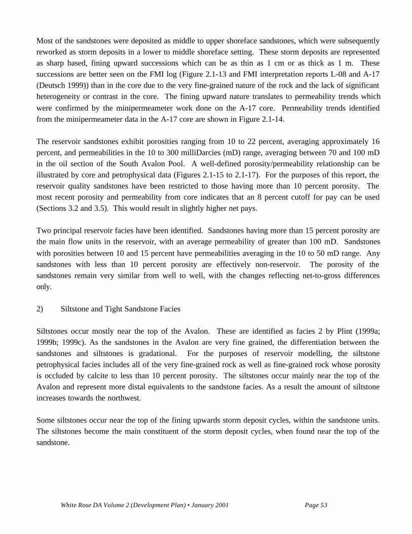
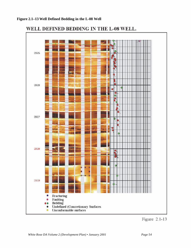
Most of the sandstones were deposited as middle to upper shoreface sandstones, which were subsequentlyreworked as storm deposits in a lower to middle shoreface setting. These storm deposits are representedas sharp based, fining upward successions which can be as thin as 1 cm or as thick as 1 m. Thesesuccessions are better seen on the FMI log (Figure 2.1-13 and FMI interpretation reports L-08 and A-17(Deutsch 1999)) than in the core due to the very fine-grained nature of the rock and the lack of significantheterogeneity or contrast in the core. The fining upward nature translates to permeability trends whichwere confirmed by the minipermeameter work done on the A-17 core. Permeability trends identifiedfrom the minipermeameter data in the A-17 core are shown in Figure 2.1-14.
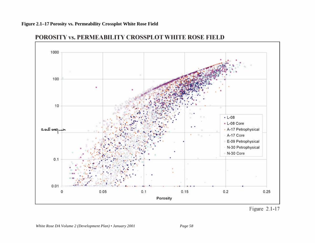
The reservoir sandstones exhibit porosities ranging from 10 to 22 percent, averaging approximately 16percent, and permeabilities in the 10 to 300 milliDarcies (mD) range, averaging between 70 and 100 mDin the oil section of the South Avalon Pool. A well-defined porosity/permeability relationship can beillustrated by core and petrophysical data (Figures 2.1-15 to 2.1-17). For the purposes of this report, thereservoir quality sandstones have been restricted to those having more than 10 percent porosity. Themost recent porosity and permeability from core indicates that an 8 percent cutoff for pay can be used(Sections 3.2 and 3.5). This would result in slightly higher net pays.
Two principal reservoir facies have been identified. Sandstones having more than 15 percent porosity arethe main flow units in the reservoir, with an average permeability of greater than 100 mD. Sandstoneswith porosities between 10 and 15 percent have permeabilities averaging in the 10 to 50 mD range. Anysandstones with less than 10 percent porosity are effectively non-reservoir. The porosity of thesandstones remain very similar from well to well, with the changes reflecting net-to-gross differencesonly.
2) Siltstone and Tight Sandstone Facies
Siltstones occur mostly near the top of the Avalon. These are identified as facies 2 by Plint (1999a;1999b; 1999c). As the sandstones in the Avalon are very fine grained, the differentiation between thesandstones and siltstones is gradational. For the purposes of reservoir modelling, the siltstonepetrophysical facies includes all of the very fine-grained rock as well as fine-grained rock whose porosityis occluded by calcite to less than 10 percent porosity. The siltstones occur mainly near the top of theAvalon and represent more distal equivalents to the sandstone facies. As a result the amount of siltstoneincreases towards the northwest.
Some siltstones occur near the top of the fining upwards storm deposit cycles, within the sandstone units.The siltstones become the main constituent of the storm deposit cycles, when found near the top of thesandstone.
White Rose DA Volume 2 (Development Plan) • January 2001 Page 54
Figure 2.1–13 Well Defined Bedding in the L-08 Well
White Rose DA Volume 2 (Development Plan) • January 2001 Page 55
Figure 2.1–14 Minipermeameter Data From Husky et al White Rose A-17

White Rose DA Volume 2 (Development Plan) • January 2001 Page 56
Figure 2.1–15 Porosity vs. Permeability Husky et al White Rose A-17

White Rose DA Volume 2 (Development Plan) • January 2001 Page 57
Figure 2.1–16 Porosity vs. Permeability Husky et al White Rose L-08
White Rose DA Volume 2 (Development Plan) • January 2001 Page 58
Figure 2.1–17 Porosity vs. Permeability Crossplot White Rose Field
White Rose DA Volume 2 (Development Plan) • January 2001 Page 59
3) Calcite Concretions
Throughout the reservoir sandstones, calcite concretions take up approximately 8 percent of the reservoirvolume. The calcite concretions are typically related to shell hash horizons. The shells have providedboth the nucleation sites and some of the calcite which was dissolved and mobilized, providing materialfrom which the nodules grew. Petrographic work suggests that the nodules occurred quite early in thediagenetic history of the Avalon (see the following section).
Interpretations from the core and FMI strongly indicate that these nodules should not extend very far in alateral extent (Figure 2.1-18). Plint (1999a; 1999b; 1999c) notes that while the nodules are presentthroughout the core, they appear to be concentrated in discrete zones.
The nodularity of the concretionary horizons is evident in more than 90 percent of the concretions seen inthe core or on the FMI. Since the concretions are related to thin (less than 5 cm) shell hash horizons, theconcretionary horizons are likely not continuous over a large area, because of the topography of theshoreline during deposition. In addition, as the shell horizons are dissolved and re-precipitated asnodules, the formation of the concretions concentrate the thin calcite into thicker, less continuous, lenses.Plint (1999a; 1999b; 1999c) postulates that the nodules would range from 5 cm to 2 m in thickness and20 cm to 3 m in width.
4) Shale Facies
In the South Avalon Pool, the shale component does not play a large role, as all of the shale is confined tothe top 30 or 40 m of the sandstone package. The shale represents the material deposited during thetransgressive event which pushed the shoreline back, southeastward of the White Rose area. Only on thefringes of the pool are there significant reserves within the shaley zone. On a pool wide basis, 8 percentof the original oil in place (OOIP) is within this shaley zone. Reservoir simulation suggests that only asmall portion of this resource will be produced.
Shale plays a larger role in the North and West Avalon Pools. In these pools, shales are present in largeramounts. The shale section at the top of the Avalon is thicker, and more shale is interbedded with thereservoir facies. This represents the more distal nature of these deposits. The presence of shales withinthe reservoir section will have more effect on the production of hydrocarbons from the reservoir, as wellas potentially having more of an effect on fault sealing.

White Rose DA Volume 2 (Development Plan) • January 2001 Page 60
Figure 2.1–18 Calcite Concretion in the L-08 Well
White Rose DA Volume 2 (Development Plan) • January 2001 Page 61
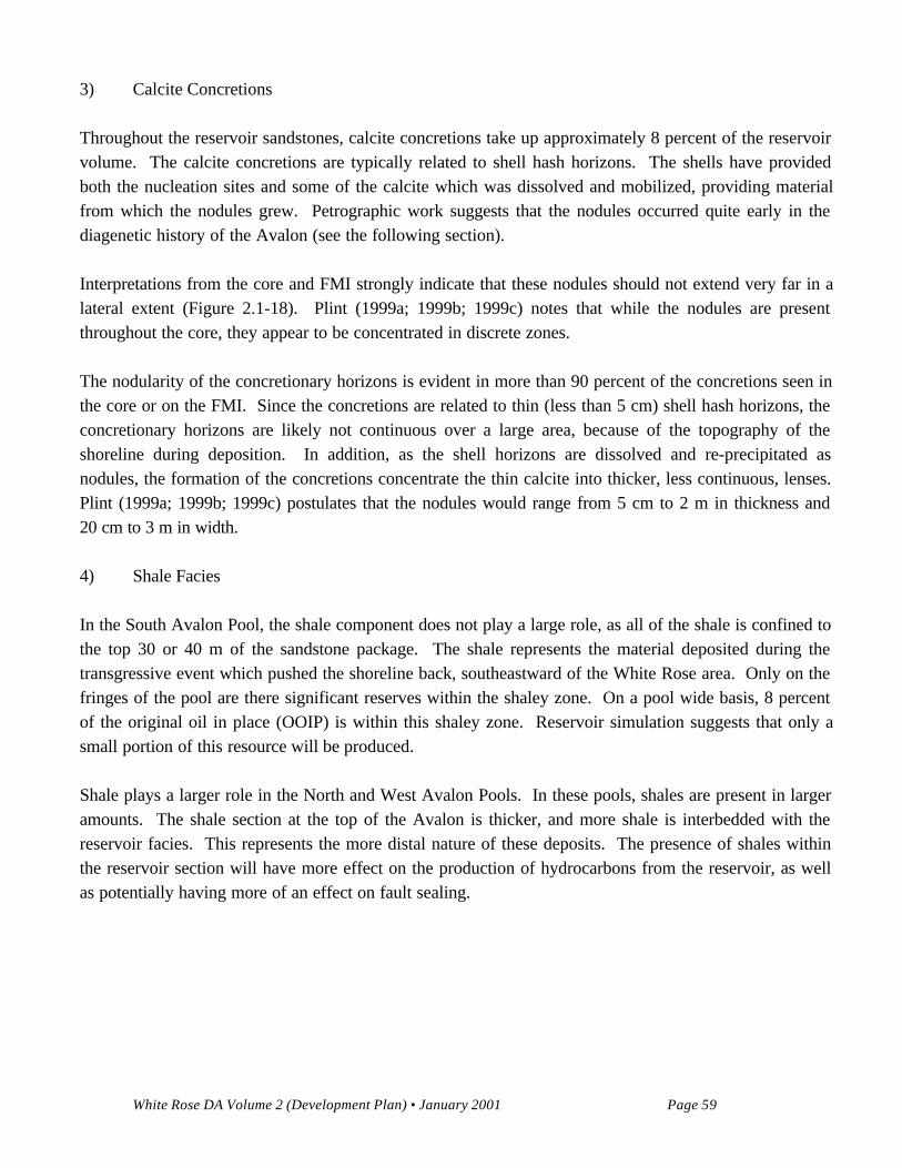
Local Tectonic Features and influence on the Reservoir
The complicated structural history of the White Rose area has left imprints on the reservoir. The FMI logwas used for the determination of bedding attitudes and the presence of faulting and fracturing within thereservoir section. Only one significant fault within the reservoir section has been penetrated in the SouthAvalon Pool. The fault is seen at 2,958 metres below rotary table (mbrt) in the L-08 well, with associatedfractures confined mainly to the hangingwall section. How the fault appears in both the core and the FMIlog is illustrated in Figure 2.1-19. Affects on the reservoir and future production are uncertain, yet withthe limited amount of faulting and fracturing seen in the wellbores, significant affects on performanceseem unlikely. As noted in Figure 2.1-19, the L-08 fault is filled with calcite as are all of the associatedfractures. The fault would form a semi-vertical barrier dipping at 80° to the wellbore. The reservoirengineering section will discuss the affects of this fault on the tests conducted in the well.
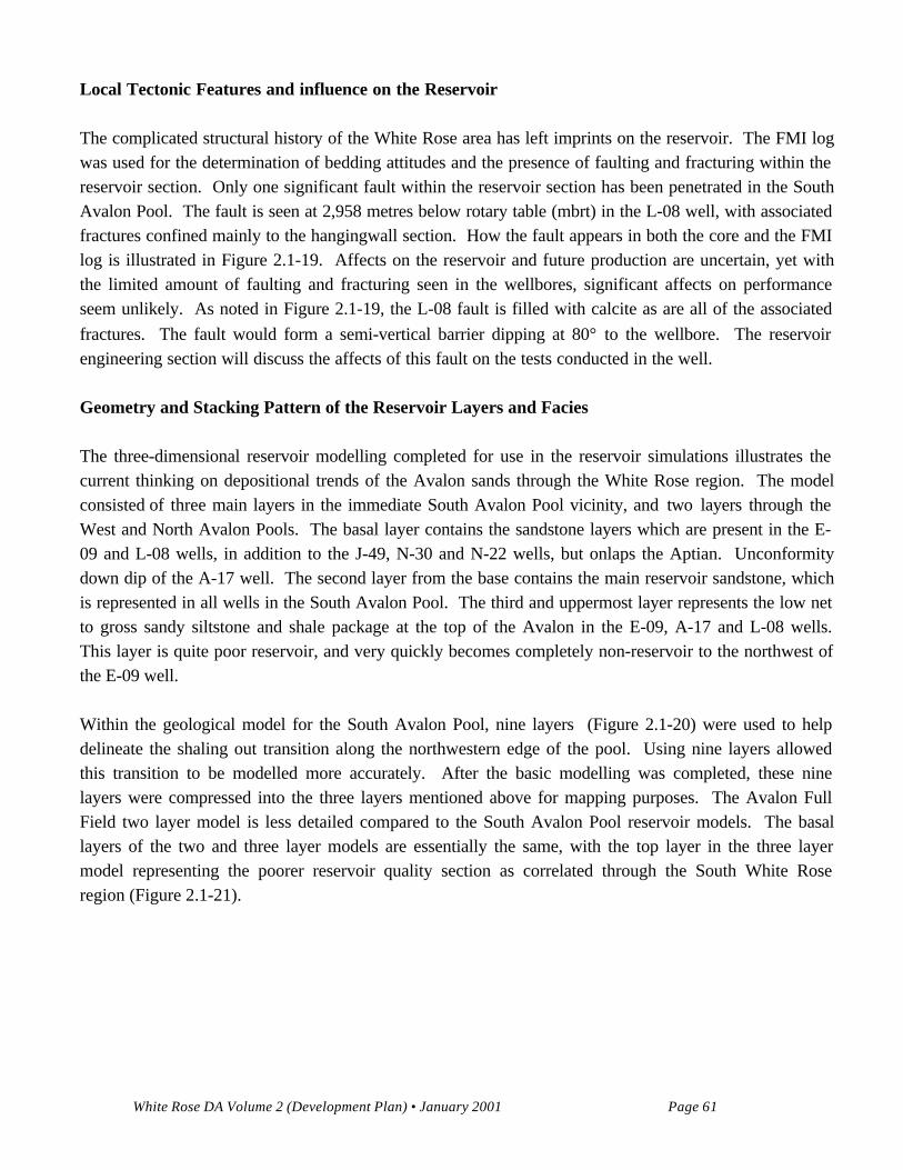
Geometry and Stacking Pattern of the Reservoir Layers and Facies
The three-dimensional reservoir modelling completed for use in the reservoir simulations illustrates thecurrent thinking on depositional trends of the Avalon sands through the White Rose region. The modelconsisted of three main layers in the immediate South Avalon Pool vicinity, and two layers through theWest and North Avalon Pools. The basal layer contains the sandstone layers which are present in the E-09 and L-08 wells, in addition to the J-49, N-30 and N-22 wells, but onlaps the Aptian. Unconformitydown dip of the A-17 well. The second layer from the base contains the main reservoir sandstone, whichis represented in all wells in the South Avalon Pool. The third and uppermost layer represents the low netto gross sandy siltstone and shale package at the top of the Avalon in the E-09, A-17 and L-08 wells.This layer is quite poor reservoir, and very quickly becomes completely non-reservoir to the northwest ofthe E-09 well.
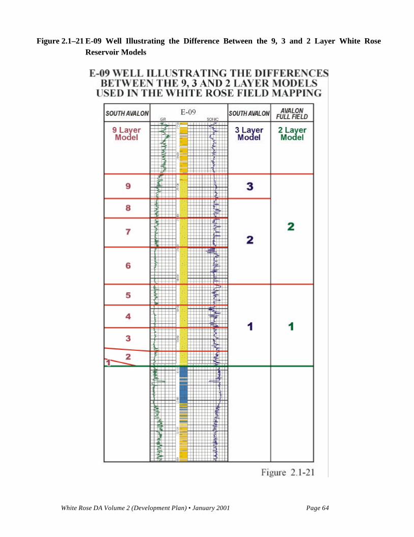
Within the geological model for the South Avalon Pool, nine layers (Figure 2.1-20) were used to helpdelineate the shaling out transition along the northwestern edge of the pool. Using nine layers allowedthis transition to be modelled more accurately. After the basic modelling was completed, these ninelayers were compressed into the three layers mentioned above for mapping purposes. The Avalon FullField two layer model is less detailed compared to the South Avalon Pool reservoir models. The basallayers of the two and three layer models are essentially the same, with the top layer in the three layermodel representing the poorer reservoir quality section as correlated through the South White Roseregion (Figure 2.1-21).
White Rose DA Volume 2 (Development Plan) • January 2001 Page 62
Figure 2.1–19 L-08 Fault Zone
White Rose DA Volume 2 (Development Plan) • January 2001 Page 63
Figure 2.1–20 South Avalon Pool 9 Layer Model
White Rose DA Volume 2 (Development Plan) • January 2001 Page 64
Figure 2.1–21 E-09 Well Illustrating the Difference Between the 9, 3 and 2 Layer White Rose
Reservoir Models
White Rose DA Volume 2 (Development Plan) • January 2001 Page 65
Trend maps were used to constrain the model to a south-southwest to north-northeast trending shorelinethrough the South Avalon Pool (Deutsch and Hallstrom 2000). The shoreline may continue to thenortheast of N-22. The J-49, N-22 and N-30 region was seaward of this shoreline and consists of moredistal deposits represented by shales and siltstones. The region to the east of this trend represents a moreproximal sand source area. The Avalon Full Field cross section (Figure 2.1-22) illustrates how thereservoir sandstone packages shale out towards the northwest. Note that the increase in shale works fromthe top of the Avalon down, with the main sandstones remaining at the base of the Formation.
2.1.3 Petrology and Reservoir Quality of the Avalon Formation
This subsection describes the petrology, diagenesis and reservoir quality of the White Rose AvalonFormation. Petrographic data includes an analysis of thin sections prepared primarily from core (orsidewall cores when core was unavailable) from seven wells in the White Rose area. These wells includeWhite Rose L-61, N-22, J-49, E-09, L-08, A-17 and N-30. Detailed petrographic descriptions are foundin reports by (Core Laboratories 2000; Haverslew 2000).
Interpretation of the Avalon Formation core indicates that the depositional environment was a marginalmarine shoreface setting with frequent storm deposits. Numerous calcite concretions varying indimensions are present, as layers of stratabound concretions or as scattered concretions. The geometry ofthe calcite concretions is controlled by the original amount and distribution of biogenic carbonate withinthe sandstones.
2.1.3.1 Primary Composition And Texture
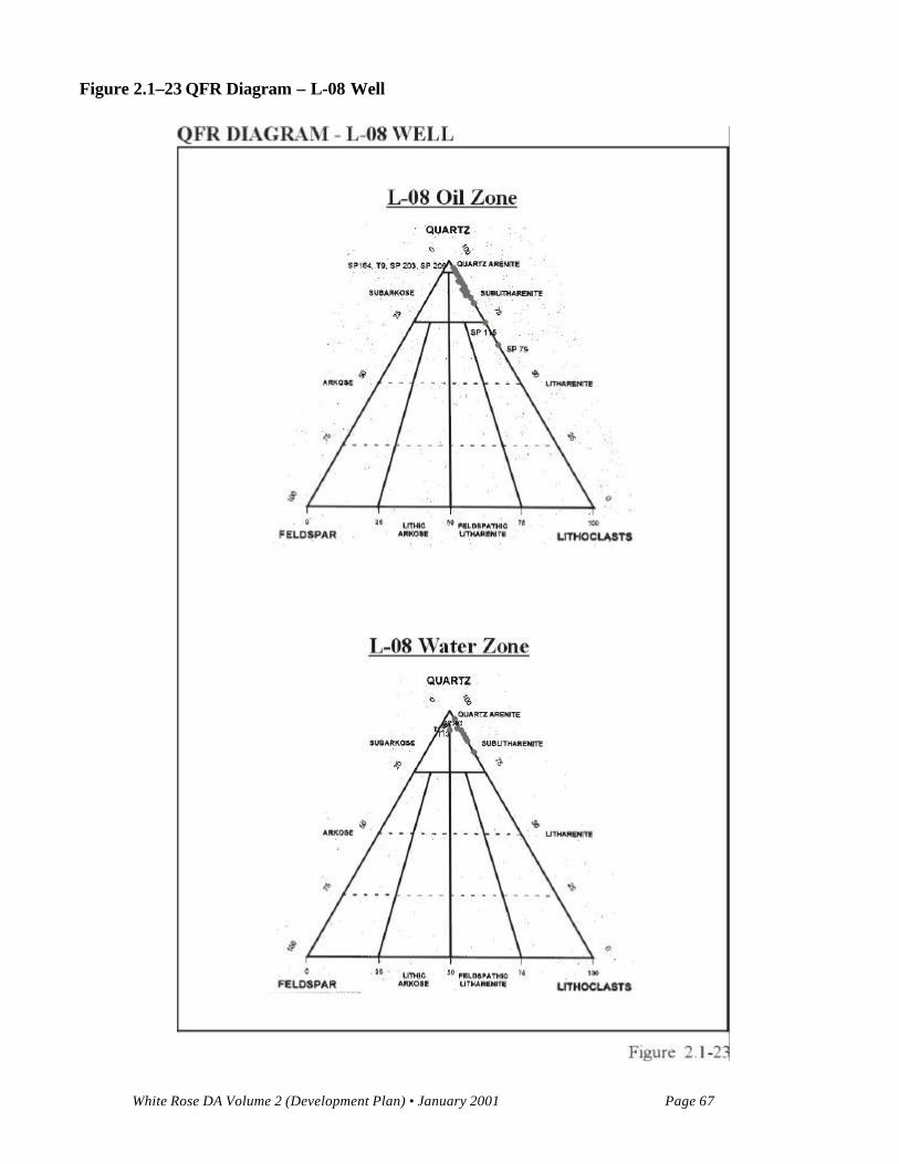
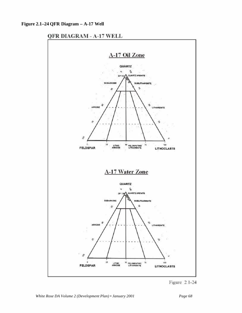
The mineralogy of the reservoir sands is predominantly 85 to 99 percent quartz and lesser amounts ofcarbonate grains, bioclastic debris, feldspar, and trace amounts of pyrite, heavy minerals, and dolomite.The reservoir sandstones have subangular to well rounded grain boundaries. Grain size is predominantlyvery fine with some fine-grained sands. The detrital quartz grains exhibit sub-angular to rounded grainboundaries and moderate to high sphericities with moderate to well sorting. The sandstones are classifiedas sublitharenite to quartz arenite. A comparison of QFR diagrams (Figures 2.1-23 and 2.1-24) from L-08 and A-17 shows a similar rock classification.

White Rose DA Volume 2 (Development Plan) • January 2001 Page 66
Figure 2.1–22 Avalon Full Field Cross Section, Facies Model, Feb. 00 Geological Model
White Rose DA Volume 2 (Development Plan) • January 2001 Page 67
Figure 2.1–23 QFR Diagram – L-08 Well
White Rose DA Volume 2 (Development Plan) • January 2001 Page 68
Figure 2.1–24 QFR Diagram – A-17 Well
White Rose DA Volume 2 (Development Plan) • January 2001 Page 69
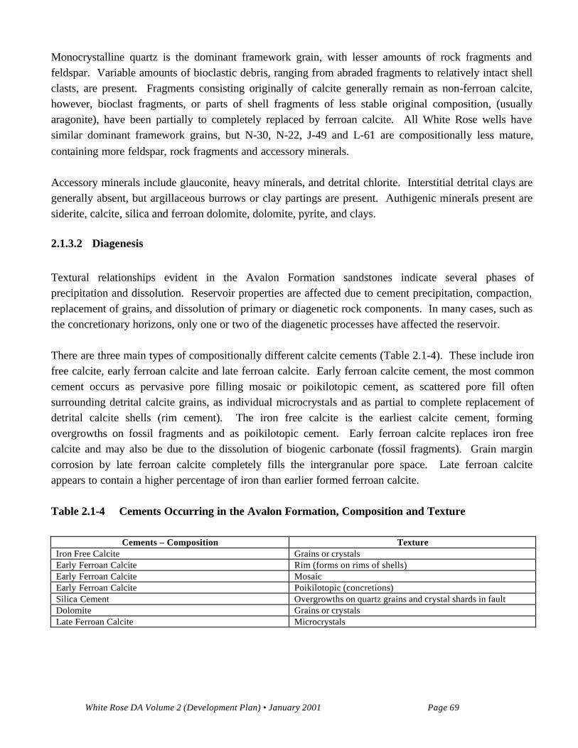
Monocrystalline quartz is the dominant framework grain, with lesser amounts of rock fragments andfeldspar. Variable amounts of bioclastic debris, ranging from abraded fragments to relatively intact shellclasts, are present. Fragments consisting originally of calcite generally remain as non-ferroan calcite,however, bioclast fragments, or parts of shell fragments of less stable original composition, (usuallyaragonite), have been partially to completely replaced by ferroan calcite. All White Rose wells havesimilar dominant framework grains, but N-30, N-22, J-49 and L-61 are compositionally less mature,containing more feldspar, rock fragments and accessory minerals.
Accessory minerals include glauconite, heavy minerals, and detrital chlorite. Interstitial detrital clays aregenerally absent, but argillaceous burrows or clay partings are present. Authigenic minerals present aresiderite, calcite, silica and ferroan dolomite, dolomite, pyrite, and clays.
2.1.3.2 Diagenesis
Textural relationships evident in the Avalon Formation sandstones indicate several phases ofprecipitation and dissolution. Reservoir properties are affected due to cement precipitation, compaction,replacement of grains, and dissolution of primary or diagenetic rock components. In many cases, such asthe concretionary horizons, only one or two of the diagenetic processes have affected the reservoir.
There are three main types of compositionally different calcite cements (Table 2.1-4). These include ironfree calcite, early ferroan calcite and late ferroan calcite. Early ferroan calcite cement, the most commoncement occurs as pervasive pore filling mosaic or poikilotopic cement, as scattered pore fill oftensurrounding detrital calcite grains, as individual microcrystals and as partial to complete replacement ofdetrital calcite shells (rim cement). The iron free calcite is the earliest calcite cement, formingovergrowths on fossil fragments and as poikilotopic cement. Early ferroan calcite replaces iron freecalcite and may also be due to the dissolution of biogenic carbonate (fossil fragments). Grain margincorrosion by late ferroan calcite completely fills the intergranular pore space. Late ferroan calciteappears to contain a higher percentage of iron than earlier formed ferroan calcite.
Table 2.1-4 Cements Occurring in the Avalon Formation, Composition and Texture
Cements – Composition TextureIron Free Calcite Grains or crystalsEarly Ferroan Calcite Rim (forms on rims of shells)Early Ferroan Calcite MosaicEarly Ferroan Calcite Poikilotopic (concretions)Silica Cement Overgrowths on quartz grains and crystal shards in faultDolomite Grains or crystalsLate Ferroan Calcite Microcrystals
White Rose DA Volume 2 (Development Plan) • January 2001 Page 70
Early ferroan calcite can be classified in three main textural fabrics, rim, mosaic and poikilotopic. Rimferroan calcite forms on the rims of the bioclastic debris, while poikilotopic ferroan calcite is a blockycement which completely occludes the pore space between the quartz grains. Mosaic cement refers toelongate crystals rimming or filling voids. Late ferroan calcite occurs texturally as pore fillingpoikilotopic microcrystals. This late ferroan calcite occurs only in the water zone.
Concretions consist of quartz grains, minor iron free calcite, ferroan calcite, and bioclastic debris (shells).Concretion formation occurs in all three zones (water, oil and gas) simultaneously. Early poikilotopicferroan calcite cement fills the pore space creating the concretions. Ferroan poikilotopic cement phaseoccurs before early quartz overgrowths indicated by the absence of quartz overgrowths in the cementedsandstones. A ferroan calcite also occurs as pervasive pore filling mosaic cement, rim cement andpartially replaces bioclasts in the concretionary horizons. The degree of replacement of bioclasts byferroan calcite is controlled by the original composition of the fragment (for example, aragonite).
Minor to moderate quartz overgrowth development has taken place on quartz grains where little to nocalcite cement is present. Silica fines are also present in a fault zone in L-08. A number of fractures areevident in thin section and core, some are filled with quartz crystals, bitumen, barite, clays (kaolinite,etc.) or with carbonate cementation.
Siderite occurs as microcrystals scattered throughout the pore system, and as a replacement of detritalclays in argillaceous burrows, clay partings and partially filling shell cavities. Pyrite occurs in trace tominor amounts, and is present as coatings on fossils (after early carbonate dissolution), and burrows.
Feldspars observed exhibit partial alteration and replacement by carbonates and clays, and dissolution ofsome grains. The gas zone in the South Avalon Pool contains more siltstone and clays than the oil orwater zones. Where clays are present as coatings around grains or as matrix, the grains are protectedfrom calcite replacement. Minor heavy minerals (zircons, garnet) sometimes occur and may be attributedto concentration by wave action along a coastline.
Paragenetic sequence for the Avalon Formation
Framework grains of quartz, bioclastic debris, with trace amounts of feldspar, siderite, and heavyminerals.
• early iron free calcite;• early Ferroan calcite;• quartz overgrowths;
• siderite, pyrite;• hydrocarbon emplacement; and• late ferroan calcite.
White Rose DA Volume 2 (Development Plan) • January 2001 Page 71
The original framework of the Avalon Formation consisted of quartz, bioclastic debris and trace amountsof feldspar (in South White Rose wells) siderite and heavy minerals. Early iron free calcite occurred andsome was replaced by early ferroan calcite. The early ferroan calcite cement occurred next in theparagenetic sequence in different textural forms as discussed above. The ferroan poikilotopic cementphase occurred before quartz overgrowths as evidenced by the absence of quartz overgrowths in thecemented sandstones. The presence of pyrite and siderite can be explained as both late and early in theparagenetic sequence. Early as crystals and late as fillings in burrows and along shell linings. Lateferroan cement appears to be present only in the water zone, which can be explained by the fact that oilmigration may have occurred just prior to this later diagenetic cement.
Reservoir Quality
The Avalon Formation is characterized by low to medium permeabilities because of the very fine-grainednature of the reservoir, and the degree of pore throat size reduction due to physical compaction and quartzovergrowths.
Porosity in the Avalon Formation is mainly primary intergranular with minor secondary moldic porosityresulting from dissolution of shells and other grains. In reservoir intervals where carbonate cement isabundant, porosity is very low due to cement plugging the pores. The presence of early carbonate cementprevents closer grain packing in response to increasing overburden. In cemented samples, shells showvery little to no evidence of flattening due to compaction: whereas in uncemented samples shells mayexhibit some deformation and flattening as a result of overburden pressure. Where a few quartz grainsare closely packed together, silica cement reduces pore space, however in general silica cement onlymoderately reduces porosity.
There are several minerals in the Avalon Formation that have the potential to cause production problems,when they occur as fine grained rock constituents. Introducing acid into this carbonate bearing formationwill introduce problems such as the formation of iron precipitates. Carbonate types are mainly calcite,ferroan calcite, and aragonite with minor siderite and dolomite. Clays in the upper portion of thereservoir may also cause problems in terms of fines migration. These clays include illite, kaolinite andchlorite (XRD/SEM analysis).
The pore system is generally clean. There is little to no authigenic clays, or other fines (with theexception of the upper portion of the reservoir) that could cause significant fines migration problemsduring production, or cause completion problems. The sandstones are competent and not friable,therefore sand production should not be a problem.
White Rose DA Volume 2 (Development Plan) • January 2001 Page 72
2.1.4 Reservoir Description: Secondary Hydrocarbon Bearing Reservoirs
A reservoir description of the secondary hydrocarbon bearing reservoirs, encountered in the White RoseField, is outlined below. Refer to Formation Tops and Fluids Sampled (Table 2.1-1a and 2.1-1b), thestratigraphy of the White Rose area (Figure 2.1-7) and the Paleocene to Late Jurassic Stratigraphic crosssection of the White Rose area (Figure 2.1-8).
The Rankin Formation was penetrated at the base of the White Rose E-09 well. This Kimmeridgian agedsection consists of a mixture of shales and siltstones with interbedded sandstones, likely the TempestMember. Drilling problems related to overpressure in this section did not allow a complete evaluation ofthis unit. An open hole test of the bottom 187 m of the well produced small amounts of gassy oil andwater. Reservoir quality is very questionable, as no cores were taken. Both overpressure and fractureswithin this fault bounded zone likely contributed to enhancing fluid flow during the test.
The Hibernia Formation has been penetrated in the A-17, E-09, N-22 and J-49 wells. The Formation canbe divided into Upper, Lower and Basal members. The Upper Hibernia is not well developed in theWhite Rose area. The Formation consists primarily of marine siltstones and shales, as it is far from themain southwest entry point into the basin. An 18-m core cut in N-22 is composed of poor qualitysiltstones and calcareous marine shales. Coarser clastics appear towards the base of the unit, whereslightly porous, fine-very fine grained, argillaceous sandstones are found. The Lower Hibernia has beenpenetrated in the E-09, N-22, A-17 and J-49 wells. Two cores cut in N-22 recovered 15 m of siltstone,shale and minor amounts of fine-grained sandstone. Minor fractures, filled with calcite, are present, butreservoir quality is poor. The zone subsequently tested 60 m³ oil. The lowermost Hibernia package, theBasal Hibernia, appears slightly better developed and tested 78 m³ oil in E-09. This unit was depositedprimarily as a prograding shoreface succession as part of an overall regional regressive Hibernia package.The shoreface succession contains minor fluvial and marginal marine deposits. The same basal unit,found 4.5 km further south in the A-17 well, is better developed and has good porosity described fromcuttings. Although not cored, secondary enhancement of the reservoir unit immediately beneath the baseAvalon Unconformity, at this location, may explain the better reservoir character. Hibernia Formationsandstone content decreases northwards, and shale content increases, until very thinly bedded, gascharged argillaceous sandstones are all that remain at Trave E-87.
The Eastern Shoals Formation has been penetrated in White Rose L-61, J-49, N-22 and N-30. In E-09and L-08, a tight basal carbonate was encountered, indicating little prospectivity under the South AvalonPool. In White Rose L-61, 13.5 m of Eastern Shoals core recovered thinly bedded sandstones, siltstonesand shales. A drill stem test from the Eastern Shoals Formation produced 0.065 106m³ gas, 24 m³ oilwith 14 percent water from a thin sandstone in White Rose J-49, indicating a separate pressure systemfrom the overlying West Avalon Pool. The Eastern Shoals Formation test (0.04 106m³ gas) and RFTpressure points in White Rose N-22 indicated the thin sandstones were in communication with theoverlying North Avalon Pool. Similarly, formation pressures in the untested upper part of the N-30
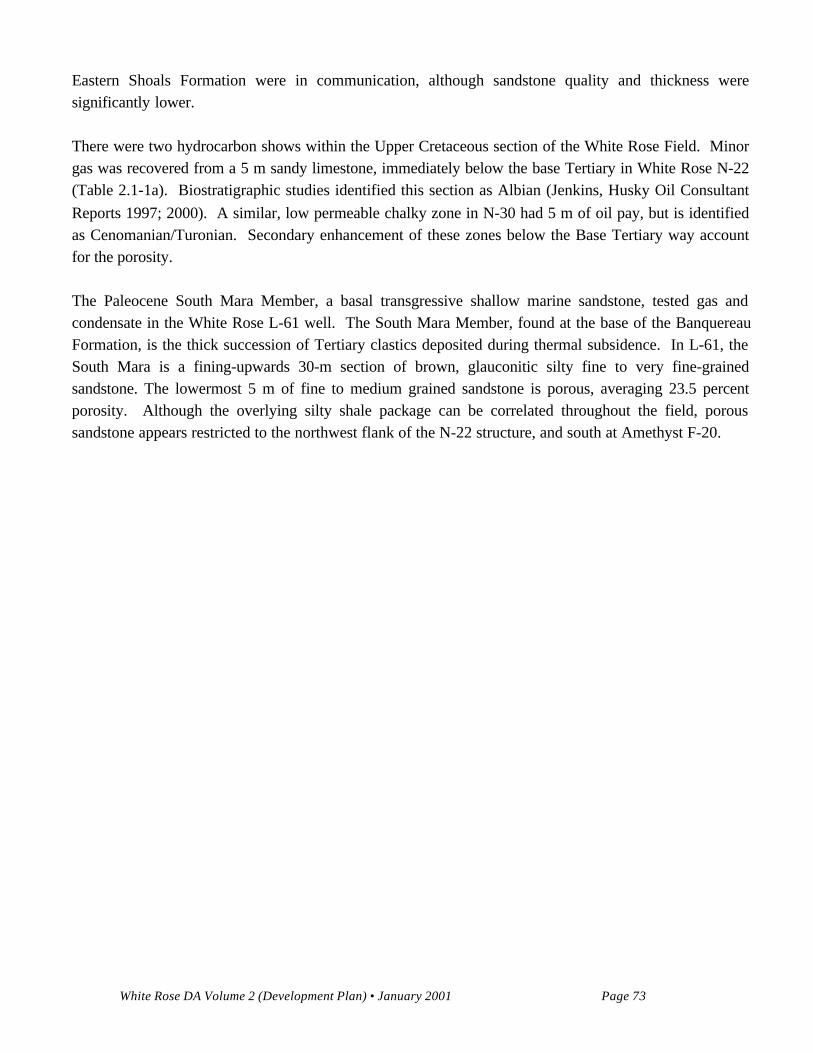
White Rose DA Volume 2 (Development Plan) • January 2001 Page 73
Eastern Shoals Formation were in communication, although sandstone quality and thickness weresignificantly lower.
There were two hydrocarbon shows within the Upper Cretaceous section of the White Rose Field. Minorgas was recovered from a 5 m sandy limestone, immediately below the base Tertiary in White Rose N-22(Table 2.1-1a). Biostratigraphic studies identified this section as Albian (Jenkins, Husky Oil ConsultantReports 1997; 2000). A similar, low permeable chalky zone in N-30 had 5 m of oil pay, but is identifiedas Cenomanian/Turonian. Secondary enhancement of these zones below the Base Tertiary way accountfor the porosity.
The Paleocene South Mara Member, a basal transgressive shallow marine sandstone, tested gas andcondensate in the White Rose L-61 well. The South Mara Member, found at the base of the BanquereauFormation, is the thick succession of Tertiary clastics deposited during thermal subsidence. In L-61, theSouth Mara is a fining-upwards 30-m section of brown, glauconitic silty fine to very fine-grainedsandstone. The lowermost 5 m of fine to medium grained sandstone is porous, averaging 23.5 percentporosity. Although the overlying silty shale package can be correlated throughout the field, poroussandstone appears restricted to the northwest flank of the N-22 structure, and south at Amethyst F-20.