1e. daytona beach international airport connector … intermodal system highway connectors...
TRANSCRIPT
Strategic Intermodal System Highway Connectors Assessment
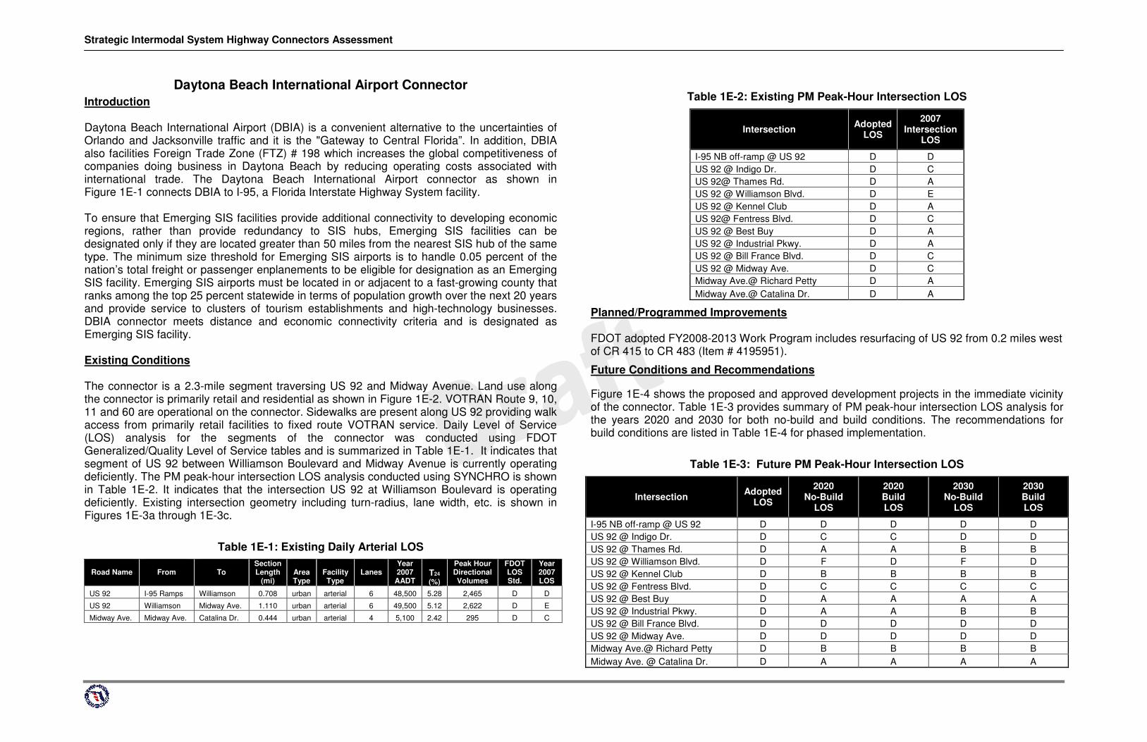
Daytona Beach International Airport Connector Introduction Daytona Beach International Airport (DBIA) is a convenient alternative to the uncertainties of Orlando and Jacksonville traffic and it is the "Gateway to Central Florida”. In addition, DBIA also facilities Foreign Trade Zone (FTZ) # 198 which increases the global competitiveness of companies doing business in Daytona Beach by reducing operating costs associated with international trade. The Daytona Beach International Airport connector as shown in Figure 1E-1 connects DBIA to I-95, a Florida Interstate Highway System facility. To ensure that Emerging SIS facilities provide additional connectivity to developing economic regions, rather than provide redundancy to SIS hubs, Emerging SIS facilities can be designated only if they are located greater than 50 miles from the nearest SIS hub of the same type. The minimum size threshold for Emerging SIS airports is to handle 0.05 percent of the nation’s total freight or passenger enplanements to be eligible for designation as an Emerging SIS facility. Emerging SIS airports must be located in or adjacent to a fast-growing county that ranks among the top 25 percent statewide in terms of population growth over the next 20 years and provide service to clusters of tourism establishments and high-technology businesses. DBIA connector meets distance and economic connectivity criteria and is designated as Emerging SIS facility. Existing Conditions
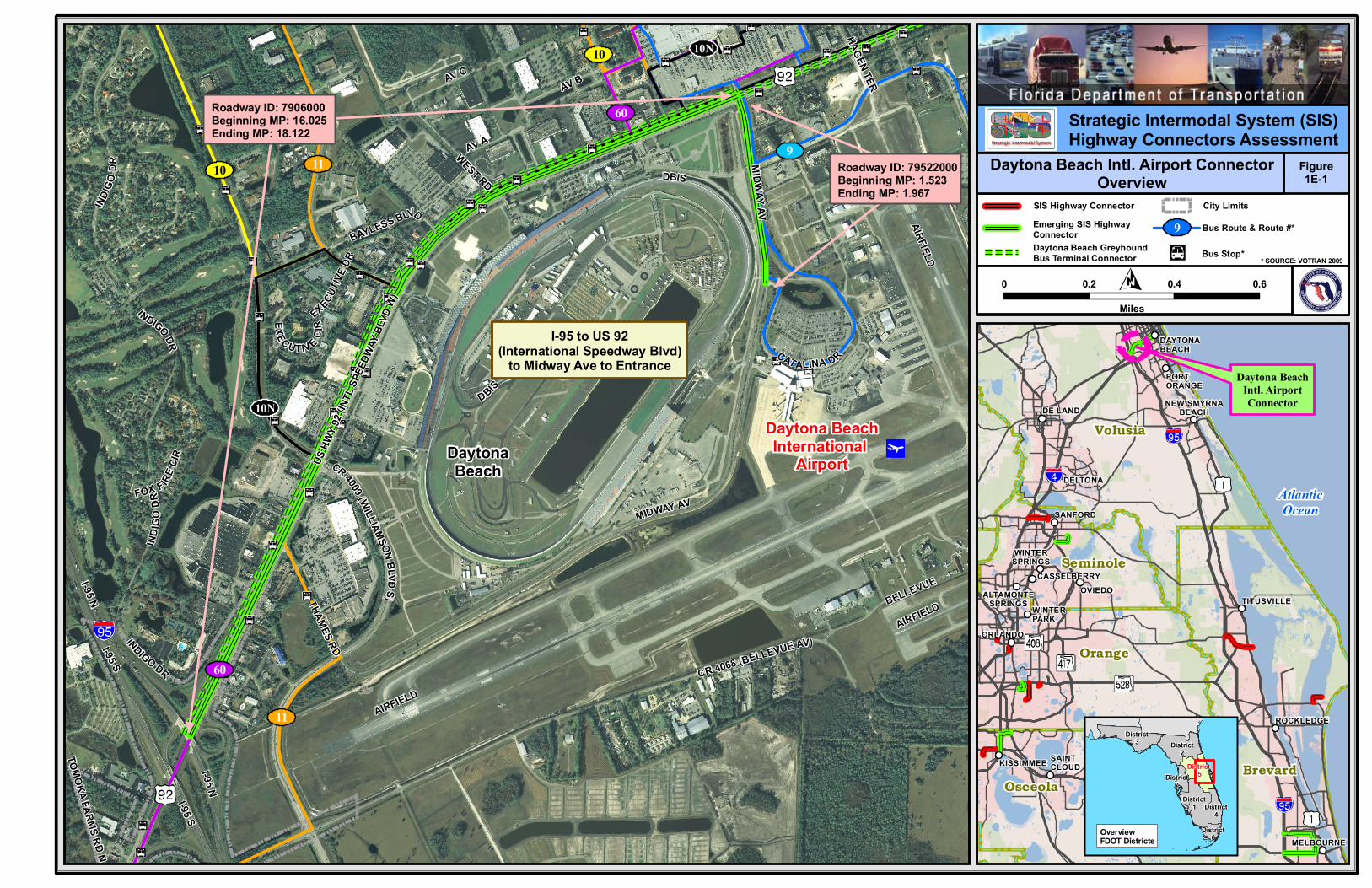
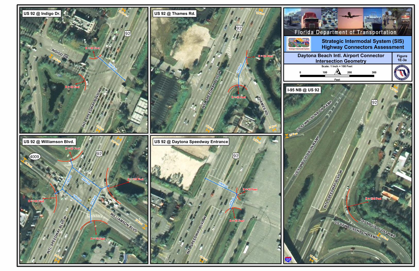
The connector is a 2.3-mile segment traversing US 92 and Midway Avenue. Land use along the connector is primarily retail and residential as shown in Figure 1E-2. VOTRAN Route 9, 10, 11 and 60 are operational on the connector. Sidewalks are present along US 92 providing walk access from primarily retail facilities to fixed route VOTRAN service. Daily Level of Service (LOS) analysis for the segments of the connector was conducted using FDOT Generalized/Quality Level of Service tables and is summarized in Table 1E-1. It indicates that segment of US 92 between Williamson Boulevard and Midway Avenue is currently operating deficiently. The PM peak-hour intersection LOS analysis conducted using SYNCHRO is shown in Table 1E-2. It indicates that the intersection US 92 at Williamson Boulevard is operating deficiently. Existing intersection geometry including turn-radius, lane width, etc. is shown in Figures 1E-3a through 1E-3c.
Table 1E-1: Existing Daily Arterial LOS
Road Name
From
To Section Length
(mi)
Area Type
Facility Type
Lanes
Year 2007
AADT
T24
(%)
Peak Hour Directional Volumes
FDOT LOS Std.
Year 2007 LOS
US 92 I-95 Ramps Williamson 0.708 urban arterial 6 48,500 5.28 2,465 D D
US 92 Williamson Midway Ave. 1.110 urban arterial 6 49,500 5.12 2,622 D E
Midway Ave. Midway Ave. Catalina Dr. 0.444 urban arterial 4 5,100 2.42 295 D C
�
�
Table 1E-2: Existing PM Peak-Hour Intersection LOS
Intersection Adopted LOS
2007 Intersection
LOS
I-95 NB off-ramp @ US 92 D D US 92 @ Indigo Dr. D C US 92@ Thames Rd. D A US 92 @ Williamson Blvd. D E US 92 @ Kennel Club D A US 92@ Fentress Blvd. D C US 92 @ Best Buy D A US 92 @ Industrial Pkwy. D A US 92 @ Bill France Blvd. D C US 92 @ Midway Ave. D C Midway Ave.@ Richard Petty D A Midway Ave.@ Catalina Dr. D A
Planned/Programmed Improvements FDOT adopted FY2008-2013 Work Program includes resurfacing of US 92 from 0.2 miles west of CR 415 to CR 483 (Item # 4195951).
Future Conditions and Recommendations
Figure 1E-4 shows the proposed and approved development projects in the immediate vicinity of the connector. Table 1E-3 provides summary of PM peak-hour intersection LOS analysis for the years 2020 and 2030 for both no-build and build conditions. The recommendations for build conditions are listed in Table 1E-4 for phased implementation.
Table 1E-3: Future PM Peak-Hour Intersection LOS
Intersection Adopted LOS
2020 No-Build
LOS
2020 Build LOS
2030 No-Build
LOS
2030 Build LOS
I-95 NB off-ramp @ US 92 D D D D D US 92 @ Indigo Dr. D C C D D US 92 @ Thames Rd. D A A B B US 92 @ Williamson Blvd. D F D F D US 92 @ Kennel Club D B B B B US 92 @ Fentress Blvd. D C C C C US 92 @ Best Buy D A A A A US 92 @ Industrial Pkwy. D A A B B US 92 @ Bill France Blvd. D D D D D US 92 @ Midway Ave. D D D D D Midway Ave.@ Richard Petty D B B B B Midway Ave. @ Catalina Dr. D A A A A

Strategic Intermodal System Highway Connectors Assessment
Table 1E-4: Daytona Beach International Airport Connector Recommended Improvements
Improvement Category Phase I (Immediate Improvements) 2008 PDC
Costs** Phase II (2009 - 2020) Improvements 2008 PDC Costs** Phase III (2021 - 2030) Improvements 2008 PDC
Costs** Geometric* - - - - - -
Operational Add second SB right turn at Williamson Blvd. *** $1,166,400 - - Add a second NB left turn lane at US 92 and Williamson Blvd. *** $619,200
Add a second SB left turn lane at US 92 and Williamson Blvd. *** $403,200 Other - - - - - - Total - $1,166,400 - - - $1,022,400
* Assume WB-62FL design vehicle. ** Costs of right-of-way, right-of-way support, landscaping, lighting, utility relocations and wetland mitigation are not included. *** These recommended improvements are common for Greyhound Bus Terminal Connector and Greyhound Daytona Beach Connector
Daytona BeachInternational
Airport
I-95 to US 92(International Speedway Blvd)
to Midway Ave to Entrance
Roadway ID: 7906000Beginning MP: 16.025Ending MP: 18.122
109
60
10
60
11
11
10N
10N
DaytonaBeach
Roadway ID: 79522000Beginning MP: 1.523Ending MP: 1.967
IND
IGO
DRFOX F IR
E CI
R
INDI
GO
DR
HAGEN
TER
AV AWEST RD
I-95 S
MID
WAY
AV
EXECUTI
VE DR
AV C
EXECUTIVE
CIR
I-95 N
AV B
INDIGO DR
BAYLESS BLVD
THAMES
RD
TOM
OKA
FARM
S R
D N
BELLEVUE
I-95 S
I-95 N
AIRFIELD
US HW
Y 92
(INTL
SPEE
DWAY
BLVD
W)
CAT ALINA DR
CR 4009 (WILLIAM
SON BLVD
S)
AIRFIELD
INDIGO DR
DBIS
CR 4068 (BELLEVUE AV)
AIRFIELD
MIDWAY AV
DBIS
AtlanticOcean
BrevardOsceola
Orange
Seminole
Volusia
Daytona BeachIntl. AirportConnector
MELBOURNE
SAINTCLOUDKISSIMMEE
ROCKLEDGE
ORLANDO
WINTERPARK
TITUSVILLEALTAMONTE
SPRINGSOVIEDO
CASSELBERRY
WINTERSPRINGS
SANFORD
DELTONA
DE LANDNEW SMYRNA
BEACH
PORTORANGE
DAYTONABEACH
District2
District3
District4
District6
District1
District7
OverviewFDOT Districts
District 5
Strategic Intermodal System (SIS)Highway Connectors Assessment
Figure1E-1
Daytona Beach Intl. Airport ConnectorOverview
SIS Highway Connector
Emerging SIS HighwayConnector
Bus Route & Route #*
Bus Stop*
0 0.2 0.4 0.6
Miles
9
* SOURCE: VOTRAN 2009
City Limits
Daytona Beach GreyhoundBus Terminal Connector

Daytona BeachInternational
Airport
I-95 to US 92(International Speedway Blvd)
to Midway Ave to Entrance
DaytonaBeach
IND
IGO
DRFOX F IR
E CI
R
INDI
GO
DR
HAGEN TER
AV A
SEA PINES C
IRI-95
S
EXECUTI
VE DR
AV C
BILL FRANCE
BLVD
INDUSTRIAL PKW
Y
MIDW
AY AV
WEST RD
EXECUTIVE
CIR
I-95 N
AV B
RICHARD PETTY BL
VD
US 92
WB
I-95
ON RA
MP
INDIGO DR
BAYLESS BLVD
INDIGO LAKES BLVD
THAMES
RD
TOM
OKA
FARM
S R
D N
I-95 NB US
92 O
FF R
MP
BELLEVUE
I-95 S
I-95 N
CR
4009 (W
IL LIAM
SON
BLVD N)
CORAL
SEA AV
AIRFIELD
US HW
Y 92
(INTL
SPEE
DWAY
BLVD
W)
CR 40
09 (W
ILLI
AMSO
N
BLVD S)
CAT ALINA DR
CR 4009
(WILLIAM
SON
BLVD N)
FENTRESS BLVD
CR 4009 (WILLIAM
SON BLVD
S)
AIRFIELD
INDIGO D R
DBIS
CR 4068 (BELLEVUE AV)
AIRFIELD
MIDWAY AV
DBIS
AtlanticOcean
BrevardOsceola
Orange
Seminole
Volusia
Daytona BeachIntl. AirportConnector
MELBOURNE
SAINTCLOUDKISSIMMEE
ROCKLEDGE
ORLANDO
WINTERPARK
TITUSVILLEALTAMONTE
SPRINGSOVIEDO
CASSELBERRY
WINTERSPRINGS
SANFORD
DELTONA
DE LANDNEW SMYRNA
BEACH
PORTORANGE
DAYTONABEACH
District2
District3
District4
District6
District1
District7
OverviewFDOT Districts
District 5
Strategic Intermodal System (SIS)Highway Connectors Assessment
Figure1E-2
Daytona Beach Intl. Airport ConnectorExisting (Year 2007) Land Use
0 0.2 0.4 0.6
Miles
Existing Land Use*
Residential
Vacant residential
Retail / Office
Public / semi-public
Institutional
Recreation
Centrally assessed
Agricultural
Acreage not zonedfor agriculture
ROW
Industrial
Mining
OtherVacant /non-residential
Water
* SOURCE: Florida Geographic Data Library (FGDL)
Wetland*
FEMA Floodplain*
City LimitsSIS Highway Connector
Emerging SIS HighwayConnectorDaytona Beach GreyhoundBus Terminal Connector
INTL
SPE
EDW
AY B
LVD
W
R = 100 Feet
12 Feet
13 Feet
15 Feet
12 Feet
I-95 NB US 92 OFF RMP
US 9
2 W
B I-9
5 SB
ON
RAM
P
US 92 WB I-95 NB ON RAMP
US 92 WB I-9
5 NB ON RAMP
Strategic Intermodal System (SIS)Highway Connectors Assessment
0 100 200 300
Feet
Figure1E-3a
Daytona Beach Intl. Airport ConnectorIntersection Geometry
I-95 NB @ US 92
Scale: 1 Inch = 100 Feet150 Feet
R = 40 Feet
12 Feet
R = 50 Feet
12 Feet
12 Feet
INDIGO DR
INTL
SPE
EDW
AY B
LVD
W
175 F
eet
R = 115 Feet
12 Feet
12 Feet
12 Feet
12 Feet
170 F
eet
150 Feet
150 Feet
R = 75 Feet
R = 80 Feet
R = 105 Feet
WILLIAMSON BLVD
INTL
SPE
EDW
AY B
LVD
W
4009
150 Feet
R = 45 Feet
12 Feet
12 Feet
65 F
eet
R = 45 FeetIN
TL S
PEED
WAY
BLV
D W
125 F
eet
R = 45 Feet
12 Feet
R = 85 Feet
12 Feet
12 Feet
THAMES RD
INTL
SPE
EDW
AY B
LVD
W
US 92 @ Indigo Dr. US 92 @ Thames Rd.
US 92 @ Williamson Blvd. US 92 @ Daytona Speedway Entrance

155 Feet
R = 40 Feet
12 Feet
12 Feet
12 Feet
12 Feet
R = 60 Feet
150 Feet
80 Feet
110 Feet
R = 50 Feet
R = 50 Feet
MID
WAY AV
INTL SPEEDWAY BLVD W
US 92 @ Midway Blvd.150 Feet
R = 45 Feet
12 Feet
12 Feet
12 Feet
60 F
eet
90 F
eet
R = 35 Feet
R = 30 Feet
R = 45 Feet
FENTRESS BLVD
INTL
SPE
EDW
AY B
LVD W
60 Feet
R = 40 Feet 12 Feet
12 Feet
30 Feet
R = 40 Feet
R = 40 Feet
INTL SPEEDWAY BLVD W
155 Feet
R = 35 Feet
12 Feet
12 Feet
12 Feet
12 Feet
160 Feet
100 Feet
120 Feet
R = 60 Feet
R = 40 Feet
R = 50 Feet
INTL SPEEDWAY BLVD W
BILL FRANCE BLVD
150 Feet
R = 80 Feet
12 Feet
12 Feet
80 Feet
60 Feet
30 Feet
25 Feet
R = 70 Feet
R = 45 Feet
R = 45 Feet
INDUSTRIAL PKWY
INTL SPEEDWAY BLVD W
US 92 @ Fentress Blvd. US 92 @ Industrial Pkwy.
U 92 @ Shopping Center US 92 @ Bill France Blvd.
Strategic Intermodal System (SIS)Highway Connectors Assessment
0 100 200 300
Feet
Figure1E-3b
Daytona Beach Intl. Airport ConnectorIntersection Geometry
Scale: 1 Inch = 100 Feet

115 Feet
R = 50 Feet
12 Feet
12 Feet
11 Feet
90 Feet
85 Feet
R = 55 Feet
MID
WAY AV
RICHARD PETTY BLVD
R = 35 Feet
11 Feet
11 Feet
R = 55 Feet
MID
WAY
AV
CATA
LINA
DR
CATALINA DR
Midway Blvd. @ Richard Petty Blvd. Midway Blvd. @ Catalina Dr.
Strategic Intermodal System (SIS)Highway Connectors Assessment
0 100 200 300
Feet
Figure1E-3c
Daytona Beach Intl. Airport ConnectorIntersection Geometry
Scale: 1 Inch = 100 Feet

Daytona BeachInternational
Airport
Daytona BeachGreyhound
Bus Terminal
I-4 E
I-4 W
I-95 S
US HWY 92 (INTL SPEEDWAY BLVD W)
SR 430 (MASON AV)
CR 4072 (BIG TREE RD)CR
4011 (RIVERSIDE
DR)
CR 4068 (BELLEVUE AV)
CR 4019 (LPGA BLVD)
US HW
Y 1
(RIDGEW
OOD
AV S)
I-95 N
SR 5A (NOVA
RD N)
CR 4050 (ORANGE AV)
CR 4019 (LPGA BLVD)
CR 4078 (REED CANAL RD)
CR 4026 (8TH ST)
CR 4040 (GEORGE W ENGRAM
BLVD)
SR 483
(CLYDE M
ORRIS
BLVD N)
I-95 S
CR 48
3 (C
LYD
E M
OR
RIS
BLV
D S)
US HW
Y 1
(RIDGEWOO
D AV)
CR 4015
(DERBYSHIRE RD)
CR
4009 (W
ILLIAMSON
BLVD N)
CR
4017
(JIM
MY
AN
N D
R)
CR 4040 (MAIN ST)
SR 5A
(NOVA
RD S)
SR 400 (BEVILLE RD)
CR 483
(CLYDE M
ORRIS BLVD N)
I-95 S
CR 430 (MASON AV)
SR 430
HYD
ROLOGYI-95 N
CR 40
09 (W
ILLIAMSO
N B
LVD
S)
HYDROLOGY
CR
415 (TO
MO
KA FA
RM
S R
D)
Airport Executive Park
AdamsMark
DaytonaBeach Int'l
Airport
LPGA
HalifaxHarborMarina
AtlanticOcean
BrevardOsceola
Orange
Seminole
Volusia
Daytona BeachIntl. AirportConnector
MELBOURNE
SAINTCLOUDKISSIMMEE
ROCKLEDGE
ORLANDO
WINTERPARK
TITUSVILLEALTAMONTE
SPRINGSOVIEDO
CASSELBERRY
WINTERSPRINGS
SANFORD
DELTONA
DE LANDNEW SMYRNA
BEACH
PORTORANGE
DAYTONABEACH
District2
District3
District4
District6
District1
District7
OverviewFDOT Districts
District 5
Strategic Intermodal System (SIS)Highway Connectors Assessment
Figure1E-4
Daytona Beach Intl. Airport ConnectorDRIs within 5 Miles from Connector
0 0.7 1.4 2.1
Miles
Proposed DRI*
Approved DRI*
* SOURCE: FDOT 2009
DaytonaBeach
HolyHill
SouthDaytona
Port Orange
City LimitsSIS Highway Connector
Emerging SIS HighwayConnectorDaytona Beach GreyhoundBus Terminal Connector