< in new mexico - usgs · provinces; the deposits of ... in new mexico the southern rocky...
TRANSCRIPT
* Radioactive Deposits in New Mexico <
GEOLOGICAL SURVEY BULLETIN 1009-L
This report concerns work done on behalf of the U. S. Atomic Energy Commission and is publishedwith the permission of the Commission
A CONTRIBUTION TO THE GEOLOGY OF URANIUM
RADIOACTIVE DEPOSITS OF NEW MEXICO
COMPILED BY T. G. LOVERING
ABSTRACT
Forty-five areas of radioactivity in New Mexico had been investigated by gov ernment geologists or reported in the geologic literature before 1952. Twenty- one areas contained visible uranium minerals and one contained thorium minerals. The occurrences were in the northwestern, north-central, central, southwestern, and southeastern parts of the State.
The deposits in northwestern New Mexico seem to be the most promising for the mining of uranium ore. In western San Juan County, on the eastern flanks of the Carrizo Mountains uplift, carnotite ore has been taken from several pros pects in the Salt Wash sandstone member of the Morrison formation. On the southern rim of the San Juan Basin in Valencia and McKinley Counties, carno tite is widely disseminated in the Todilto limestone and the Morrison formation of Jurassic age and the Dakota formation of Cretaceous age. Farther south in the Zuni Mountains of Valencia County joint coatings in pre-Cambrian granites show abnormal radioactivity, but no uranium minerals have been found.
Many types of radioactive deposits have been found in north-central New Mexico. This region, contains 4 radioactive copper deposits, in sandstones, 3 radioactive lignites or black shales, 2 radioactive spring deposits, and a uranium- and thorium-bearing pegmatite district.
In central New Mexico only two deposits, one in the San Acacia or San Lorenzo district in Socorro County and the other in the Scholle district in Torrance County, had been reported. The former deposit consists of autunite, torbernite, and uranophane sparsely disseminated in a breccia zone near the edge of a Tertiary andesite flow; the latter consists of carnotite associated with carbonized wood and secondary copper minerals in Permian sandstones.
The radioactive deposits of southwestern New Mexico include the White Signal and Black Hawk districts in Grant County and the Terry prospect in Sierra County. In the White Signal district autunite and torbernite are asso ciated with veins and basic dikes cutting pre-Cambrian granite and diabase. In the Black Hawk district pitchblende is associated with nickel, cobalt, and silver minerals in quartz veins cutting pre-Cambrian granite. On the Terry prospect, near Monticello, uranophane occurs in a breccia zone cutting limestones of Mississippian age, which have been altered to jasperoid.
In many of the Lea County oilfields of southeastern New Mexico the brines, which are associated with oil from Permian strata, are radioactive; however, the uranium content of these brines is extremely low, and it seems unlikely that they will ever become a commercial source of uranium.
315
316 CONTRIBUTIONS TO THE GEOLOGY OF URANIUM
The only commercial deposits of uranium ore in New Mexico, known before 1952, are in the northwestern part of the State. A plant has been constructed near Grants, in Valencia County, to process this ore. The southwestern region also has several promising uranium deposits and additional exploration may prove they contain valuable reserves of uranium ore. The few tons of ore available on the Merry Widow claim in the White Signal district and the presence of pitch blende at Black Hawk suggest that further exploration here may discover im portant ore reserves. Information available on the rest of New Mexico does not indicate the presence of any important sources of uranium ore under market conditions prevailing at the end of 1951.
INTRODUCTION
SCOPE AND PLAN OP THE REPOBT
The purpose of this report is to summarize the information available on uranium deposits and uranium mining activity in New Mexico before 1952. 1 The report has been divided into three main sections. First, a general discussion and comparison of the geology and miner alogy of the deposits as a whole is presented in the section entitled
"Radioactive deposits." Second, in the body of the report, the radio active localities are described by counties which are arranged alpha betically in the report. For each occurrence the location, general geology, mineralogy, and radioactivity are summarized and references are given to published reports covering the area. In the final section, "Conclusions" (p. 382), it is pointed out that, although the uraniumdeposits in New Mexico are diversified and widely distributed, onlya few offer much hope of commercial development under economicconditions existing in 1952.
HISTORY OF URANIUM INVESTIGATIONS AND MINING
The earliest mention in geologic literature of a uranium mineral fromNew Mexico was in 1902, when a brief anonymous note mentioningthe occurrence of uraninite in the President mine near Elizabethtown,Colfax County, appeared in tHe Mining and Scientific Press. No other
references to this occurrence are known to the author. Lindgren,
Graton, and Gordon (1910) noted the presence of carnotite in PeraitaCanyon, Cochiti district, Sandoval County and of torbernite in the Jerome copper mine, San Lorenzo district, San Acacia, Socorro County.The first record of the samarskite-bearing pegmatites near Petaca
appeared in Mineral Resources of New Mexico for 1915. In 1920 thedisCOvery of autunite and torbernite in the White Signal district ana
pitchblende in the Black Hawk district In Grant County was recordedIn the Engineering and. Mining Journal (Leach, P. I., 1920). Wells
(1924) reported carnotite in the Scholle district in Socorro County and
> While this report was in preparation more recent information on the Grants district, Coyote Creek, and La Ventana Mesa became available and has been included.
RADIOACTIVE. DEPOSITS IN NEW MEXICO 317
in the Carrizo Mountains in San Juan County. Northrop (1942) mentions cyrtolite, uraninite, and samarskite from pegmatites on Elk Mountain in San Miguel County. During World War II the deposits at White Signal, Black Hawk, San Lorenzo, and Petaca were re- examined for uranium, and a new radioactive microlite deposit was discovered in the Rociada district, Mora County.
Since World War II the carnotite-bearing limestone and sandstone deposits near Grants in Valencia and McKinley Counties, discovered in 1949 and examined by U. S. Geological Survey and U. S. Atomic Energy Commission geologists the following year, have attracted con siderable interest. By the end of 1951 a mih1 was being set up near Grants to treat these ores and preparations were being made to mine them on a large scale. In 1950 a note in the Engineering and Mining Journal reported that secondary uranium minerals had been found in a mine in the Organ district, Dona Ana County.
Before 1952, 45 radioactive occurrences in New Mexico had been examined by U. S. Geological Survey and U. S. Atomic Energy Com mission geologists or reported in the geologic literature. Deposits of carnotite in the Salt Wash sandstone member of the Morrison forma tion have been found on the eastern flanks of the Carrizo Mountains in San Juan County; although the deposits are small and scattered they are locally rich and a considerable amount of uranium ore has been shipped from them. In Grant County, southwestern New Mexico, autunite and torbernite are associated with pyritic quartz veins cutting pre-Cambrian(?) granitic rocks and younger intrusives in the White Signal district. There have been reports that pitch blende is present in argentiferous base-metal sulfide ore in fissure vein deposits of the nearby Black Hawk district. Although no uranium ore has been shipped from either the Black Hawk district or White Signal district recently, they both seem to be worthy of further exploration. None of the remaining radioactive occurrences known in New Mexico before 1952 contained known reserves of uranium ore under market conditions existing at that time.
During the last few years many new radioactive deposits have been investigated by geologists of the U. S. Geological Survey and the U. S. Atomic Energy Commission. Some of the new deposits are the radio active copper deposits in Sandoval and Rio Arriba Counties, a urano- phane prospect in Sierra County, radioactive coals and black shales in Sandoval and Mora Counties, and radioactive brine in oilfields of Lea County. As yet, however, no uranium ore of minable grade has been found in any of these localities, except possibly at La Ventana Mesa in Sandoval County.
Before 1952 the only uranium ore produced in New Mexico came from the Grants district and the Carrizo Mountains. The first ship ment from the Grants district was made in the fall of 1950. Since
354333 56 2
318 CONTRIBUTIONS TO THE GEOLOGY OF URANIUM
that time extensive exploration has proved the existence of a large tonnage of ore distributed over a considerable area in this district. During the 1920's a few carloads of autunite and torbernite mixed with sericite were mined and shipped from the Merry Widow mine, in Grant County, to be used in "activated water" and face powder.
ACKNOWLEDGMENTS
This report was compiled largely from published and unpublished reports by members of the U. S. Geological Survey on work done on behalf of the Division of Raw Materials of the U. S. Atomic Energy Commission and from reconnaissance reports by members of the Atomic Energy Commission. The unpublished information has been combined with information published in the geologic literature before 1952. The length of each report section on a deposit is dependent On the amount of hitherto unpublished information available.
Unpublished memorandum reports are slightly condensed under the original title and the original author. The information in recon naissance reports is summarized. Published reports by government geologists are abstracted with a reference to the published report. Other published reports are included in the bibliography and manyof them are referred to in the section entitled, "Other reported occurrences."
The information On the deposits hi the northwestern region has
been taken mostly from an unpublished report (1950) by Fischer and Strobell. Rappaport (1952) has written about the Grants district, and unpublished reports by Sheridan (1950) and by Rosenzweig (1950) also Supplied information about the district. Reports by Stokes (1951), Ellsworth (written communication, 1951)j and Hatfield (written communication, 1951) were used for information on the de posits in the Carrizo Mountains district. Most of the descriptions of properties in the north-central region were taken from an unpub-lislxed report (1951) by Bachman and Read. The deposits hi thecentral rsgion were examined by oott and Erickson (unpublishedreport, 1951). The information on the southwestern region Was taken mostly from unpublished reports by Granger and Bauer (1950a, 195la? ; t>y Ora^SOT <io Soa., iosob>, and by Bauer (1950). One repOPtby Granger anJ BaUeP (1950) Oil foe region has ^ P l̂ist d . McNeal wrote a report (unpublished, i950a) on the Lea Countyoilfields in the southeastern region.
GENERAL DESCRIPTION OF NEW MEXICO
New Mexico includes parts of four physiographic provinces; these are (Fenneman, 1931) the Great Plains, the Southern Rocky Mountains, the Colorado Plateaus, and the Basin and Range. The provinces
RADIOACTIVE DEPOSITS IN NEW MEXICO 319
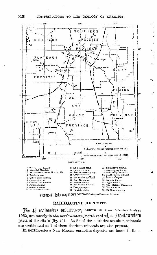
not only have contrasting topographic features but also have dis tinctive geologic features. The northwestern uranium region of New Mexico is in the Colorado Plateaus physiographic province; the deposits in the north-central region are partly in the Colorado Plateaus and partly in the Southern Rocky Mountains physiographic provinces; the deposits of central and southwestern New Mexico are in the Basin and Range physiographic province; and the single occurrence in the southeastern region is in the Great Plains physio graphic province. (See fig. 49.)
The Great Plains occupy approximately the eastern third of the State. The southern and central parts of this physiographic province are characterized by gently rolling high plains of slight relief; but the northern part is characterized by buttes and mesas, many of which are capped with lava flows of Tertiary or younger age. The central, southern, and eastern parts of the province in New Mexico are under-. lain by sedimentary rocks of late Paleozoic, Triassic, Cretaceous, and Tertiary age.
In New Mexico the Southern Rocky Mountains physiographic province includes the lofty Sangre de Crisfco and southern San Juan Mountains, which extend southward from Colorado along both sides of the Rio Grande Valley and terminate at about the latitude of Santa Fe. Both of these ranges, which separate the Great Plains from the Colorado Plateaus, have cores of pre-Cambrian crystalline and metamorphic rocks and are flanked by Paleozoic and Mesozoic sedimentary rocks and Tertiary volcanic rocks.
South of the southern Rockies, the Great Plains adjoin the Basin and Range physiographic province which occupies the southwestern part of New Mexico; it is characterized by isolated mountain ranges separated by broad graded desert plains. Many of the ranges are tilted fault blocks composed of paleozoic sedimentary rocks; but some are composed of pre-Cambrian granite and others of Tertiary volcanic rocks.
North of the Basin and Range province and west of the southern Rockies is the Colorado Plateaus physiographic province. The New Mexico part of the Colorado Plateaus consists of two nearly equal areas. The southern part, which Fenneman (1931) calls the Datil section, consists of a malpais of dissected volcanic flows and tuffs. This rugged and little known region occupies the area between the middle Rio Grande valley and the Arizona State line. The northern part of the Colorado Plateaus of New Mexico is a land of buttes, mesas, and wide plains. Structurally the area is a broad basin known as the San Juan Basin; belts of Triassic and Jurassic sedimentary rocks appear around its borders. The only commercial deposits of uranium ore known in the State before 1952, occur in these belts within the Colorado Plateaus,
320 CONTRIBUTIONS TO THE GEOLOGY OF URANIUM
j i 7 U T H E R N /i
\ () t_ ;~~k f. P F5WI c""g /
I__________ Mont
P R 0| V I N C E I27
LEXPLANATION
Radioactive deposit referred to in the text
1 Oak Springs deposit
2 Beautiful Mountain3 Navajo Reservation (district 12)4 Toadlena area5 Cobre basin district6 Coyote district7 Copper City district8 Jarosa district9 Petaca district
106°
EXPLANATION
11 La Ventana Mesa12 Jerttez Springs
13 Spanish Queen 'group14 Grants district15 San Ysidro coalfield16 Zuni Mountains17 Scholle district18 San Acacia district
19 Terry prospect20 Virginia claim
FIGUEE 49 -Index map of New Mexico suo
21 Black Hawk district22 White Signal district23 Lea County oilfields24 Elizabethtown district25 Peralta Canyon26 Rociada district27 Organ district28 Little Hatchet Mountain29 Glorieta area30 Elk Mountain area
radioactive deposits.
RADIOACTITE
The 45 radioactive occurrences, imow» ^ ^o1952, are mostly in the northwestern, north central,parts of the State (fig. 49). At 21 of the localities uranium mineralsare visible and at 1 of them thorium minerals are also present.
In northwestern New Mexico carnotite deposits are found in lime-
RADIOACTIVE DEPOSITS IN NEW MEXICO 321
stones and sandstones of Jurassic age. These deposits are scattered over large areas in the Grants and Carrizo Mountains districts.
The radioactive deposits of north-central New Mexico are some what more diversified, but the majority of them are of two types: uraniferous copper deposits associated with carbonized plant remains in arkoses, sandstones, and siltstones of Permian and Triassic age; and radioactive coals and black shales of Jurassic and Cretaceous age. In addition, 2 radioactive spring deposits and 1 pegmatite district containing uranium, thorium, and rare-earth minerals are within this region.
In southwestern New Mexico, 2 of the 3 radioactive deposits are associated with veins cutting pre-Cambrian granites and younger intrusives; the third is in a fracture zone in brecciated Mississippian(Y) limestone, which has been altered to jasperiod.
At one locality in central New Mexico carnotite is associated with carbonized wood and copper in Permian sandstones; at another locality secondary copper and uranium minerals are disseminated in a breccia zone near the edge of a Tertiary andesite flow.
Only one radioactive occurrence had been reported from the Great Plains of eastern New Mexico before 1952. The deposit consists of a radioactive precipitate from brines associated with Permian rocks in the oilfields in the southeastern corner of the State.
TYPES OF DEPOSITS
The places where uranium deposits in New Mexico are found differ greatly in geology and topography, but deposits of a given type are often found in very similar areas though they may be far apart. The following outline shows the classification the writer has adopted:
A. Disseminated deposits.1. Sandstones.2. Limestones and travertine.3. Coal and black shale.
B. Oilfield brines. C. Fissure deposits.
1. Veins.2. Breccia and shear zones.
D. Pegmatites.DISSEMINATED DEPOSITS
The disseminated deposits, especially those in sandstones and lime stones, appear to be the most promising economically.
The disseminated deposits in sandstone include the carnotite de posits of the Grants district, in Valencia and McKinley Counties, the deposits of western San Juan County and many of the sandstone copper deposits of Mora, San Juan, and Rio Arriba Counties. In most of these deposits the uranium minerals are in permeable lenses
322 CONTRIBUTIONS TO THE GEOLOGY OF URANIUM
of continental sandstones, closely associated with carbonized wood fragments and other fossil plant material.
The disseminated deposits in limestone are confined, so far as is now known, to the Todilto limestone in the Grants district of Valencia and McKinley Counties. Preliminary studies of this new district indicate that uranium minerals most commonly form a paint or stain along joints and bedding-plane fractures in the limestone, though small carnotite pods and lenses are also scattered through the lime stone. The factors that control the distribution of these pods and lenses have not yet been discovered. Although the secondary uranium mineral carnotite is the chief economic mineral in the Grants district, some pitchblende has been identified from deposits in tfre Todilto limestone (Anonymous, 1951).
The radioactive travertine deposits of Jemez Springs and Caseman well represent a special type of radioactive calcareous sediments. At Jemez Springs maximum radioactivity is associated with black sooty layers and lenses in the white tufa. Most of these lenses are less than 4 feet long and 1 foot thick, but the largest are as much as 15 feet long and 2 feet thick. The distribution of radioactivity in the deposit at Caseman well was not determined.
Radioactive layers of coal and black shale are found at San Ysidro and La Ventana Mesa in Sandoval County and near Coyote in Rio Arriba County. The radioactivity is evenly distributed through layers that are COIHmODly less than 1 foot thick and of unknown lateral extent.
OILFIELD BRINES
Abnormal radioactivity has been detected in oilfields of Lea County in southeastern NeW MfiXiCO. The radioactivity emanates from a precipitate, deposited from brines, on the well casings.
FTSStJRB DEPOSITS
The fissure deposits include the quartz-Silver bUSS-ffletftl 161118 of the Black Hawk district, the quartz-pyrite-chalcopyrite veins and the fracture zones of the White Signal district, the breccia zone in jaspeTOid On the Terry prospect, and the fracture zone in volcanic
The only vein deposits in the state containing P ^ ^_minerals that were known by 1952 are the quartz VelnS 01 tn6 BlftCK Hawk district. Uranium is associated With pods and lenses of basemetal and Silver sulfides scattered tlirough. the veins. All mine
workings in the Black Hawk district are now inaccessible; thereforethe dimensions and the distribution of these ore bodies could not be determined. Because of information in old reports, however, it seems
RADIOACTIVE DEPOSITS IN NEW MEXICO 323
probable that the veins are narrow and the ore shoots small and lenticular.
The deposits of the White Signal district, the Terry prospect, and the San Acacia district all contain secondary uranium minerals errati cally distributed as coatings on fractures and linings of voids. In all three places the uranium minerals were deposited recently. Uranium minerals in the three areas, however, differ greatly in the environment of deposition. In the White Signal district the deposition of secondary uranium minerals occurred near oxidizing pyritic quartz veins and basic dikes cutting pre-Cambrian granites. The Terry prospect near Monticello exposes secondary uranium minerals coating vugs in vein- lets that cut a breccia zone consisting of fragments of a jasperoid re placing Paleozoic limestone and a feldspar porphyry. At San Acacia a Tertiary andesite flow has been fractured near one edge. Secondary uranium minerals are widely distributed through this fractured zone as paint and fracture coatings.
PEGMATITES
The only radioactive pegmatites in the State that have been studied as a possible source of uranium are those near Petaca in east ern Rio Arriba County. Rare radioactive minerals are present in small pods replacing feldspar. A few crystals more than an inch in diameter have been taken from these replacement deposits but the individual pods are rarely more than a foot in diameter. The pods are widely and erratically distributed within the individual pegmatite dikes.
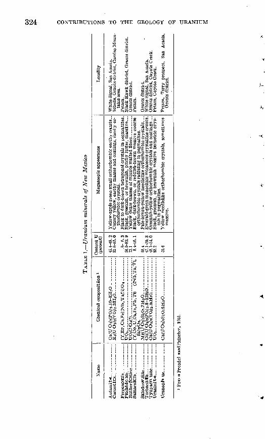
MINERALOGY
Both primary and secondary uranium minerals are known in New Mexico but those of secondary origin are by far the most common. Table 1 indicates the locations and characteristics of uranium minerals in New Mexico that had been identified before 1952. The radioactive silver ores of the Black Hawk district and the uraninite-bearing peg matites near Petaca (Hess and Wells, 1930, p. 17-26) are primary; blebs of pitchblende have been reported from the Grants district (Rappaport, 1952), and small amounts of uraninite have been found in copper sulfide nodules at Coyote Creek, Mora County. All other occurrences of uranium minerals thus far reported are of a secondary origin. These include autunite and torbernite deposits of the White Signal district, uranophane near Monticello, and tyuyamunite and carnotite deposits in Valencia, McKinley, San Juan, and Mora Counties. No uranium minerals have yet been found in the radio active carbonaceous matter in Rio Arriba and Sandoval Counties, in the radioactive spring deposits in the valley of the Jemez River, or in the radioactive brines in the Lea County oilfields. The primary
324 CONTRIBUTIONS TO THE GEOLOGY OF URANIUM
S !?vs
-5«
^ffl<i H.
^ O
goo
S*K** *s fr
Ii i!ig!llli I li .;11 i°l ralllllIs I
(NO WOl
06 «5 CCOi
go ^-
r-jM ^
00 ^
00 ?
i oiff _;mo'i E-^ o <N ?
,'PM 5*9 S
RADIOACTIVE DEPOSITS IN NEW MEXICO 325
deposits in the Black Hawk and Petaca districts differ considerably in their mineralogy, but they are similar in that both are in areas of pre-Cambrian rocks.
The fissure veins in the Black Hawk district consist principally of carbonates, silicified carbonates, barite, and jasperiod. Within this gangue are small irregular pockets of pitchblende, pyrite, galena, sphalerite, chalcopyrite, niccolite, rammelsbergite, cobalt skutterudite (smaltite), native silver, and argentite. Some of the rich silver ores are highly radioactive, but the source of their radioactivity is not yet known. These deposits are similar in mineralogy to some in northern Canada, where pitchblende is associated with silver ores.
Near Petaca, in eastern Bio Arriba County, a quartz-feldspar pegmatite in pre-Cambrian quartz-mica schist contains an unusual amount of radioactive minerals. Microcline feldspar has been cut by vein quartz, and both were later replaced by albite and mica. The radioactive minerals consist of crystals and irregular masses of mona- zite, fergusonite, uraninite, and samarskite that also replace the microcline.
The secondary uranium minerals show an even greater variation in mineralogic association, as might be expected because of their wider distribution within the State.
In the Todilto limestone deposits, carnotite is associated with black oxides of iron and manganese, and, in places, with pitchblende, the uranium carbonate rutherfordine, and the uranium silicates urano- phane and sklodowskite. In the deposits in the Morrison and Dakota formations, on the other hand, the carnotite tends to be associated with carbonaceous material and secondary vanadium minerals rather than with iron and manganese oxides.
The radioactive copper deposits are associated also with carbo naceous material but are quite different from the carnotite deposits. In the radioactive copper deposits uranium minerals are rarely visible and radioactivity is commonly associated with deposits of secondary copper minerals, such as chalcocite, malachite, azurite, and chrysocolla. At Coyote Creek in Mora County uraninite has been identified from copper sulfide nodules in black shales, and tyuyamunite is sparsely disseminated in arkosic sandstones.
The association of radioactivity and carbonaceous material also characterizes the coal and carbonaceous shale beds of San Ysidoro and La Ventana Mesa in Sandoval County and the black shale beds near Coyote in Rio Arriba County where neither copper nor uranium min erals can be found.
In the oilfields of Lea County the abnormal radioactivity is asso ciated with water rather than with petroleum. The hot spring waters that are depositing radioactive tufa near Jemez Springs and at
354333 56 3
326 CONTRIBUTIONS TO THE GEOLOGY OF URANIUM
Caseman well in Sandoval County contain only negligible quantities of uranium. Their radioactivity is due to the presence of small amounts of radium.
Near Monticello, hi Sierra County, a silicified breccia is cut by veinlets of quartz and fluorite. In the veinlets are vugs partly filled by white clay, hydrous iron oxide, uranophane, and fluorescent hyalite formed in that order.
URANIUM CONTENT OF DEPOSITS
The percent of uranium hi the deposits listed in table 12 indicates the uranium content of the richest samples on which analyses were available before 1952. The samples range from small hand specimens to channel samples many feet in length. Consequently, the percent figure gives, at best, only a roughly qualitative idea of the value of the best material in the uranium deposit. The richest samples range from more than 12 percent uranium for a samarskite specimen from Petaca down to a few thousandths of a percent for some of the radioactive sandstone copper deposits. Deposits hi 9 areas in the State had yielded, before 1952, reliable samples containing more than 0.1 percent uranium. These are the White Signal and Black Hawk districts in Grant County, the Carrizo Mountains area in San Juan County, the Grants district in Valencia and McKinley Counties, La Ventana Mesa in Sandoval County, the Petaca pegmatites in Rio Arriba County, Coyote Creek in Mora County, and the Terry prospect and Virginia claim in Sierra County. The occurrence on the Virginia claim can hardly be considered a deposit; it consists of one small specimen of uraniferous ilmenite float, the origin of which is unknown. All of theremaining deposits described in this report were too low in grade to beof economic interest. Their chief importance is that they outline
large areas of uranium-bearing rocks for future exploration.The terms eU for equivalent uranium (estimated from radioac
tivity) and U for uranium (chemically determined) are used frequentlyin assay data throughout this report. Equivalent uranium content of
a sample is what the uranium content would be if all radioactivityWere due tO uranium in equilibrium with its daughter products. A
significant difference between eTJ and TJ may be due to differential Or enrichment, insufficient age for equilibrium to be estab-
i, or the presence of radioactive potassium or thorium.
OS.IGHIT
The original sources of uranium, from which most of the radioactive deposits of New Mexico have been derived, are still largely unknown. Magmas, from which veins and pegmatites were derived, were prob ably the origin of the primary uranium-bearing minerals in the veins
RADIOACTIVE DEPOSITS IN NEW MEXICO 327
of the Black Hawk district and of the samarskite, uraninite, and monazite at Petaca.
Determining the primary sources of the secondary radioactive deposits so widely scattered through the State is a fascinating problem. Although most of the deposits appear to be of secondary origin the presence of pitchblende in some of the carnotite deposits throughout the State indicates that they were probably derived from oxidation of primary uranium minerals. The origin of the solutions which de posited the primary uranium-bearing minerals is not known.
In most parts of New Mexico where radioactive deposits are known large areas are covered by Tertiary volcanic rocks. Some of these volcanic rocks, especially those of the Jemez and Mount Taylor fields in northern New Mexico, contain traces of uranium. It is possible that deposits of uranium minerals in nearby sedimentary rocks are the result of leaching from the volcanic rocks and later precipitation in the underlying sedimentary rocks. On the other hand, all the regions where radioactive deposits are known, except the Lea County oilfields, are underlain at no great depth by ancient crystalline and metamorphic rocks that also contain uranium-bearing minerals in small amounts and offer an equally probable primary source. Indeed, the uranium minerals of the White Signal deposits are more probably derived from the pre-Cambrian granite than from the Tertiary volcanic rocks.
Still another possibility is that the secondary uranium minerals may have been derived from primary uranium minerals in hydro- thermal vein deposits by leaching and reconcentration in ground water. The primary source of radioactivity in the oilfields of Lea County is still unknown. Much work remains 4to be done before the original source of any of the secondary-uranium-mineral deposits in New Mexico can be determined.
DESCRIPTION OF MINES AND PROSPECTS
GRANT COUNTY
The following information has been taken from an unpublished compilation report on the uranium deposits of Grant County by H. C. Granger, H. L. Bauer, Jr., T. G. Levering, and Elliot Gillerman (1953).
The known uranium deposits of Grant County are principally in the White Signal and Black Hawk districts. Both districts are within a northwestward-trending belt of pre-Cambrian rocks composed chiefly of granite and included gneisses, schists, and quartzites. Younger dikes and stocks are present in the pre-Cambrian complex. The White Signal district is on the southeast flank of the Burro Mountains; the
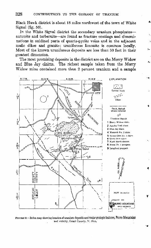
328 CONTRIBUTIONS TO THE GEOLOGY OF URANIUM
Black Hawk district is about 18 miles northwest of the town of White Signal (fig. 50).
In the White Signal district the secondary uranium phosphates autunite and torbernite are found as fracture coatings and dissemi nations in oxidized parts of quartz-pyrite veins and in the adjacent mafic dikes and granite; uraniferous limonite is common locally. Most of the known uraniferous deposits are less than 50 feet in their greatest dimension.
The most promising deposits in the district are on the Merry Widow and Blue Jay claims, The richest sample taken from the Merry- Widow mine contained more than 2 percent uranium and a sample
EXPLANATION
Tyrone stock
Dikes
Fault, dashed where inferred
o'Uranium deposit
1 Merry Widow claim2 Apache Trail claim3 Blue Jay claim4 Monarch No. 2 claim5 Tunnel Site No. 1 clai6 Uncle Sam mines
7 Black Hawk district8 Hines No. I prospect
9 Langford prospect
NEW MEXICO j
,GRANT CO '.
IBURRO MOUNTAINS!AND VICINITY [
FIGURE 50. Index map showing location of uranium deposits and major geologic features, BU1TO MOUflt8fflS and vicinity, Grant County, N. Mex.
RADIOACTIVE DEPOSITS IN NEW MEXICO 329
from the Blue Jay property contained as much as 0.11 percent; samples from the other properties were of lower grade.
In the Black Hawk district pitchblende is associated with nickel, silver, and cobalt minerals in fissure veins. The most promising properties in the Black Hawk district are the Black Hawk, Alhambra, and Rose mines. No uranium analyses of ore from this district were available in 1951.
There are no known minable reserves of uranium ore in either district, although there is some vein material at the Merry Widow mine of ore grade.
WHITE SIGNAL, DISTRICT
By H. C. GRANGER and H. L. BATTER, JR.
Most of the mines and prospects in the White Signal mining district are in T. 20 S., R. 15 W., New Mexico principal meridian, and are within a few miles of the store and post office of White Signal.
Gold, silver, and copper minerals were found in the White Signal district in the late 1800's (Keith, written communication, 1945a), and mining activity was begun on the Merry Widow, Apache Trail, Tunnel Site, and Uncle Sam properties, and on many others not dis cussed in this report. In the early 1900's the rich near-surface ores were mined out, and since that time production has been small. About 1920 secondary uranium minerals were recognized on old dumps by A. A. Leach, and offers of as much as $50 per ton for high- grade uranium ore revived mining activity. The uranium minerals, autunite and torbernite, were embedded in plaster plaques to be used in "activitating" water for drinking, bathing, and watering plants. Two carloads of torbernite, clay, and sericite from the Merry Widow mine were produced for the manufacture of radioactive face powder. Neither of these enterprises was successful. The Union Mines Development Corporation made two examinations (Keith, written communications, 1944, 1945a) of the uranium deposits in the White Signal district. Postwar interest in uranium again revived prospect ing activity. Granger and Bauer, of the U. S. Geological Survey, examined several of the known uranium-bearing deposits in the area during late 1949 and early 1950.
MERRY WIDOW CLAIM
The Merry Widow claim (fig. 50) is near the center of sec. 22, T. 20 S., R. 15 W., New Mexico principal meridian. It is 0.7 mile by dirt road northwesterly from the Silver City-Lordsburg highway at a point about 0.5 mile west of White Signal. The Merry Widow is one of a block of 6 claims, the Acme, Acme No. 1, Merry Widow, Merry
330 CONTRIBUTIONS TO THE GEOLOGY OF URANIUM
Widow No. 1, Ace in the Hole, and Deuce in the Hole, controlled in 1950 by A. G. Hill, of Dallas, Tex.
The Merry Widow mine was located in the 1880's as a gold property and was operated until exhaustion of the easily accessible ores in the early 1900's forced suspension of mining activity. After the discovery of uranium in the district, the mine was reopened during the 1920's and two carloads of ore containing a mixture of autunite, torbernite, sericite, and clay were shipped. The mine was again closed down and no further shipments are recorded.
The mine workings were examined and sampled for uranium by Keith (written communication, 1945). During February and March 1950 a geologic map on the scale of 1 inch equals 100 feet was made of the Merry Widow claim (pi. 17) by Granger and Bauer. Five exploration trenches and the 40- and 60-foot levels of the Merry Widow mine were mapped; 133 samples (table 2) were collected. The geologic map of only one of the trenches has been included in this report. (See pi. 18). During May 1950, diamond drilling was done on the Merry Widow claim by the owner and 650 feet of drill core was logged by Granger and Bauer.
Mine workings. The Merry Widow mine consists of a 150-foot shaft, inclined from 65° to 72° SE., and about 450 feet of workings on 4 levels at 40, 60, 90, and 130 feet. In 1950 the mine was inaccessible below the 60-foot level. Both the 40- and 60-foot levels were mapped on a scale of 1 inch equals 10 feet (pi. 19).
In addition to the mine workings, 5 shallow trenches have been excavated on the claim (pi. 17).
Geology. The Merry Widow claim is in an area underlain by a large pre-Cambrian granite mass that is cut by numerous dikes ranging in composition from basalt to rhyolite,
The granite near the Merry Widow claim (pi. 17) is typically medium grained but locally coarse grained to porphyritic. It is composed essentially of feldspar and quartz, with less than 5 percent
biotite. TKe feldspar is partly argillized.Two thick diabase dikes and several thin basalt, dikes (pi. 17),
probably of the same age, are exposed on the Merry Widow claim. The dikes strike northwest and dip northeast. The diabase dikes, which are as much as 35 feet thick, have narrow chilled borders, less than 3 feet thick, that are similar in texture to the basalt dikes.
The centers of the diabase dikes have a coarse ophitic texture. Ablanket of dark soil covers the diabase except near a vein where thediabase is commonly hardened by iron oxides and silica.
Several altered gray aphanitic dikes cut both the diabase and graniteon the Merry Widow claim. These dikes, referred to as latite(?), are almost completely altered to clay minerals. The latite(?) dikes
RADIOACTIVE DEPOSITS IN NEW MEXICO 331
TABLE 2. Analyses of samples from the Merry Widow claim, White Signal district,Grant County, N. Mex.
Sample no.
Trench 1 HLB-1-1.....
2.....3.....4.....5 6 7.....8.....9.....10 11 12.....13 14.....15.....16 17 18 19.....20 21.....22.....23 24.....25 26 27.....28 29.....
Trench % HLB-2-30
31 32....33....34....35....36 37 38 39....40. 41....42....43 44....45 46 47
HLB-6-48....HLB-7-49 Trench 6 HLB-5-50... .
51 52....53 54....55....56 57....58 59....6061....62....63 .
Trench 8 HLB-3-64...
65 66 67....68 69 70 71
Locality no.
R-ll....
±v-y.----
R-10....
R-7.
JR-8_
Material
.....do ...----....----...
.....do ......................
..-.do ......--.-.......-.--..Latite ........................
. do
.....do.... .......................
.....do... ...... .. ..... .......
.....do ........ ................
.....do ........ ...............
X -do...
.....do..... ......................
... ..do..... .......... ............
.....do .......... .............
.....do..... ......................
.....do. ......................
.....do.....
.... .do.. ............. .......... .
.--do .. _. -----
.....do ...
do -...do ... .. . ................
. do..
... ..do.. -
..... do
Inch thick.
Type
... do Grab
...do..... ..
...do ...
...do ...
...do... ....
...do..... ..
...do... ....
...do..... ..
...do .
...do ..
...do..... ..
...do .
...do ..
...do..... .. do ...do ......do .....do..... .....do ....do.... ......do ....do .....do ...do.. ..
...do
...do ..
...do -
.-.do.......
...do ...
...do .
...do..... -.
...do .
...do .
...do.......
...do .
...do .
...do ..
...do .
...do.......
...do.... ...
...do .
...do.......
...do.-. do
do ...do ....do .. do ...do.... ......do ....do ....do ....do ..... do.... ...... do ......do ....do... .......do
Chip......
...do ..
...do... ....
...do-
Length of
sample (feet)
2.72.9
2.02.52.5.5
2.62.51.5.3
1.51.52.02.0
2.02.02.52.02.02.52.01.72.73.02.03.03.0
3.04.13.03.12.53.03.03.02.52.53.32.03.03.03.82.63.06.53.03.0
3.02.03.03.01.32.01.72.02.01.61.02.02.01.5
2.01.52.5.5
2.530.02.52.5
eU (per cent)
0.004.004.007.002.002.002.003.004.004.006.023.008.005.009.005.005.004.007.003.009.004.004.009.100.029.005.010.005.006
.011
.003
.008
.006
.013
.004
.006
.005
.005
.006
.006
.011
.008
.006
.005
.004
.004
.006
.016
.020
.005
.006
.005
.020
.002
.005
.008
.005
.004
.008
.014
.007
.005
.005
.004
.005
.005
.005
.009
.006
.008
.010
.008
U (per cent)
0.002.001.006.001.001.001.001.001.001.003.019.004.003.005.003.003.002.002.002.007.003.003.009.11.025.004.009.004.002
.005
.002
.005
.003
.015
.003
.003
.003
.002
.005
.004
.008
.005
.005
.003
.002
.002
.007
.010
.010
.004
.004
.002
.002
.002
.002
.003
.002
.001
.006
.010. 002.002.001
.001
.001
.004
.004
.007
.005
.005
.007
.004
PsOs (per cent)
0.13.13.54
2.612.692.60.83.10.20.09.53.10.10.14.06.17.10.07.07.23.09.13.14
1.182.181.791.65.18.12
.08
.06
.14
.561.421.701.62.35.04.15.11.04.10.07.11.09.06.15.97.46
1.72.95.08.08.07.07.06.04.08.08.13.06.04.07
.13' .07
.22
.231.482.542.31.40.32
332 CONTRIBUTIONS TO THE GEOLOGY OF URANIUM
TABLE 2. Analyses of samples from the Merry Widow claim, White Signal district, Grant County, N. Mex. Continued
Sample no.
Trench S Con 73... 74 75 76 77 78
HLB-3-79 8081
HLB 82.... 83
HLB-9-84 HLB-10-85
86 87... 88... 89 90 91 92... 93...94...
HLB-10-95 96...
HLB-11-97 98...99...
100...HLB-12-101.-
102...103... 104...105...
Trench 4 HLB-4-106
107...108...109...110...111...112 ..113...114... 115...116...117...118...119...120...121...
123...124
126...127...isa ...129... 130...131...132...
Locality no.
K,....R-5
JR-3 -
JR-2_ _
R-l.
R-13---
.... ..
Material
Granite, altered... _ . . . .do
Latite.. __ .-... _ ...--.-..--.
Quartz-pyrite vein, 24 in. thick.
Granite, altered ___ _ ..-.Granite.
/Diabase, iron-stained ___ .. \_ do
do
Granite, torbernite _ .
Granite, altered. .. _ -... .
Granite, altered..... _ .-.--.-..
Quartz monzonite..----. -.---...
Granite -- Quartz-pyrite vein and gouge ....
Latite ..... Granite. ........... .............Latite
Granite.. --.-.-.-. _ ........... Latite ... .....Granite.. __ _ , _ __ .
Granite and quartz-pyrite veins. . do
Type
Channel. Chip -
do ... do .... do Chip... -
...do Channel. - do ......do Chip. ..
Channel . . do. ....do ....
do. .-.do ...do ....do ....Grab... ...do Channel _ Grab .Channel ... do .... do .......do... . do ....do Grab
Chip.... .. Channel ... ..-do Chip... ... do ...do.... ...do ...do .. do
do Channel ... Chip . Channel- Chip... Channel ... Chip... Channel .Chip _ ....Cnannel ... Chip. . Onannel...Ohlp------ Channel Chip.. ..do Raljwtori
Length of
sample (feet)
2.5 17.0 7.0 1.5 3.0 2.0 2.5
13.0 14.0 1.5 1.7 2.5 2.9
2.5 2.5 3.0
3.0
2.5 2.5 2.0 2.0 2.0 2.0
17.0 3.0 1.0 4.5
26.0 29.0 31.0 77.0 9.0
26.0 26.0 33.0 6.0
18.0 .5
18.0 2.09.04.0
37.0 e.o 17.0 5.0
24.04.0
40.0 40.0
eU (per cent)
0.004 .005 .005 '.006 .004 .003 .004 .005 .003 .017 .012 .76 .010 .021 .010 .017 .005 .003 .005 .092 .002 .005 .007 .004 .005 .004 .004 .005 .87 .039 .098 .018 .10
.004
.003
.002
.004
.002
.005
.002
.006
.003
.004
.002
.006
.003
.000
.005
.005
.010
.005
.005 .004.007.001 .001 .001 .008 .005.004 .021
U (per cent)
0.002 .002 .002 .006 .002 .001 .001 .002 .001 .020 .015 .67 .006 .020 .006 .020 .003 .001 .001 .10 .001 .001 .003 .001 .001 .001 .004 .001 .092 .034 .077 .014 .070
.001
.001
.001
.001
.001
.001
.001
.001
.001
.001
.001
.001
.001
.001
.002
.001
.008
.003
.004
.001
.OO7
.001
.001
.001
.008
.001
.001
.014
PsO. (per cent)
0.06 .06 .07 .15 .13 .15 .08 .11 .08 .41 .59 .42
2.09 1.60 .26 .66 .08 .47 .05
1.56 .45 .02
1.14 .06 .08 .05 .58
2.51 1.69 2.11 1.77 2.11 .44
.14
.39
.27
.10
.43
.08 2.58 .04 .43 .13
2.02 .03 .10 .03 .19 .06 .28 ,03 .30 .07.31.08 .32 .05.36.07.04 .07
strike easterly in the southern half of the claim but strike north- eaSterlj in the northern half J the dikes therefore, may be of different
age. They are concealed by soil at the surface and can be seen Only in mine workings and prospect pits.
Thick northeastward-trending dikes of quartz monzonite porphyry (pi. 17) cut the granite in the northern part of the Merry Widow
RADIOACTIVE, DEPOSITS IN NEW MEXICO 333
claim. The porphyrylias*quartz£phenocrysts up to 8"mm across in a finer groundmass.
Three small exposures of a dark fine-grained rock, tentatively identified as diorite(?), were mapped (pi. 17). The exposures are irregular and discontinuous and no relation to other rocks is apparent.
A series of aphanitic greenish rhyolite dikes, exposed in an east ward-trending zone (pi. 17), are believed to be the most recent intru sive rocks on the Merry Widow claim. Other rhyolite dikes in the district commonly strike slightly north of east, but the individual dikes on the Merry Widow claim strike northwesterly.
Structure. The rocks on the Merry Widow^claim have been complexly faulted and fractured, but displacement can be determined only where the larger faults offset dikes, as much as 60 feet in some places. In the southern half of the claim most of the faults have easterly trends, but in the northern half most of them strike northerly or northwesterly. The significance of this change in the fault pattern is not known. Most of the faults have steep dips, ranging from 60° to vertical.
Faults on the Merry Widow claim are commonly filled by quartz and limonite vein material or by other intrusive rocks. Many of them are characterized by limonite filling or wide altered zones rather than by breccia, slickensides, or other direct evidence of faulting. Many small faults are so well cemented by quartz and limonite that they are very inconspicuous.
Joints on the Merry Widow claim show no persistent trend; locally joints may have a uniform strike, but another conflicting set may appear a few feet away. The persistent joint sets commonly have the same attitude as nearby faults or dikes, suggesting that they may be minor fractures in shear zones.
Uranium deposits. Most of the uranium on the Merry Widow claim is in the eastward-striking Merry Widow vein zone, although small patches of uranium-bearing rock are widely scattered throughout the area. The highest uranium assays in the Merry Widow vein zone were obtained within 100 feet of the Merry Widow shaft.
Veins of three distinct types are found on the Merry Widow claim: barren quartz veins; quartz-hematite (specularite) veins which ap parently contain no metallic element other than iron; and quartz- pyrite veins, the most common type. Uranium is associated with the quartz-pyrite veins. Pyrite in the quartz-pyrite veins near the surface is thoroughly oxidized to limonite. Quartz is commonly dense and erratically distributed. It occurs as pods, lenses, and veinlets but rarely as a prominent continuous fissure filling. Granite wall rock bordering the veins is stained by hydrous iron oxides and, in most places, either silicified or altered to clay minerals and sericite.
354333 56 4
334 CONTRIBUTIONS TO THE GEOLOGY OF URANIUM
Fracture zones are filled with massive vitreous limonite or cellular limonite containing scattered masses and blebs of vein quartz.
Where the diabase dikes are cut by the veins they are commonly impregnated with hydrous iron oxide and with silica which makes them relatively resistant to weathering.
Hydrous iron oxides are abundant in the near-surface parts of the veins on the Merry Widow claim. Limonite, either massive with conchoidal fracture or cellular, fills many of the veins. The pul verulent form of limonite is also common, and in places it invades the altered rhyolite. Limonite in and near the vein was produced by oxidation of pyrite, and perhaps of chalcopyrite. Pyrite may be found near the surface where shielded from alteration, as within the masses of vein quartz.
Bismite (bismuth trioxide), associated with small pockets of high-grade gold ore, has been reported from the Merry Widow mine but none was recognized by Granger and Bauer.
Some green minerals, exposed on the walls of the Merry Widow mine, are believed to be copper sulfates. They are similar in appear ance to torbernite and may easily be confused with it.
Secondary uranium minerals are found at several localities on and near the Merry Widow claim. In the field, the flaky yellow fluores cent uranium minerals were called autunite and the flaky or tabular green weakly fluorescent and nonfluorescent uranium minerals were called torbernite. No distinction was made between torbernite and metatorbernite.
Autunite and torbernite usually are found in and near the inter sections Of diabase OF basalt dikes with quartz-pyrite veins. Both minerals coat fracture surfaces and project into small cavities in the fracture blocks. The fractures and cavities are also commonlyiron stained. Locally, as in trench 2 (locality R 7, pi. 17) and at shaft 2, torbernite Crystals are disseminated in the granite and coat altered grains of feldspar. Although, autunite locally is most aDUn- daflt Dear the Surface, torbernite is predominant a few feet below the
surface.In 1950 the only uranium-bearing rock of economic importance
known on. tiiis claim. wa,s within the area developed by the MerryWidow mine (table 3). The measured uranium-bearing rock ^ ^mine iS defined Vertically by the surface of the ground and the 130- foot level; horizontally it is defined by the eastern limits of the 40-,60-, find 13(MOOt leYelS and the western limits Of tHe 40- and 130-foot
leYels, The highest grade ore is within 20 feet Of the Shift between the 60-foot level and the surface.
The size and grade of uranium deposits on and near the Merry Widow claim, exclusive of the mine, are indicated in table 4. The
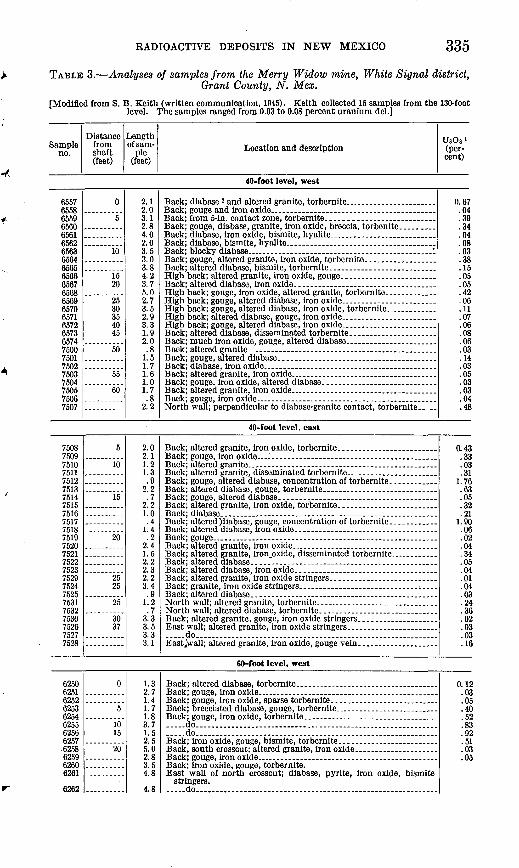
RADIOACTIVE DEPOSITS IN NEW MEXICO 335
TABLE 3. Analyses of samples from the Merry Widow mine, White Signal district,Grant County, N. Mex.
[Modified from 8. B. Keith (written communication, 1945). Keith collected 15 samples from the 130-foot level. The samples ranged from 0.03 to 0.08 percent uranium del.]
Sample no.
Distance from shaft (feet)
Length of sam
ple (feet)
Location and descriptionUsOs' (per cent)
40-foot level, west
6557655865596560656165626563
.6564656565666567656865696570657165726573657475007501750275037WU
750575067507
0
5
10
1520
2530354045
50
55
60
2.12.03.12.84.02.03.53.03.84.23.75.02.73.52.93.31.92.0.8
1.51.71.61.01.7.8
2.2
Back; diabase, iron oxide, bismite, hyalite.-. ........................Back; diabase, bismite, hyalite ......................................
High back; altered granite, iron oxide, gouge.... __________
Back; altered granite... . ...- __ . _____________Back; gouge, altered diabase. ... ___________________
Back; altered granite, iron oxide. ______________ ..........
0.67.04.39.34.04.08.03.38.15.05.05.42.06.11.07.06.08.06.03.14.03.05.03.03.04.48
40-foot level, east
750875097510
751275137514751575167517751875197520752175227523752975247525753175327530752675277528
5
10
15
20
2525
25
3037
2.02.11.21.3.9
2.2.7
2.21.0.4
1.4.2
2.41.52.22.32.23.4.91.2.7
3.33.53.33.1
Back; altered granite, iron oxide, torbernite... ___________
.....do........ _ ........... _ ....................................
0.43Q3.03.311.76.63.05.32.21
1.90.06.02.04.34.05.04.01.04.03.24.36.02.03.03.16
60-foot level, west
62506251625262536254625562566257.6258625962606261
6262
0
5
1015
20
1.32.71.41.71.83.71.52.55.02.83.54.8
4.8
__ do ________________ . _____ . _________ .... do.............................................................
stringers. .....do.....,-...... . . .............
0.12.03.05.40.52.83.92.51.03.05
336 CONTRIBUTIONS TO THE GEOLOGY OF URANIUM
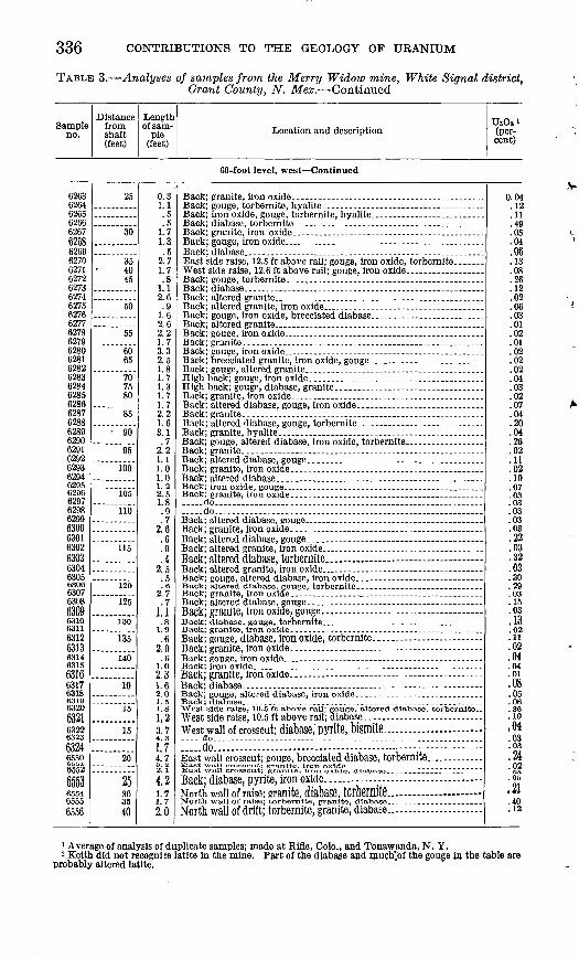
TABLE 3. Analyses of samples from the Merry Widow mine, White Signal district, Grant County, N. Mex. Continued
Sample no.
Distance from shaft (feet)
Length of sam
ple (feet)
Location and descriptionUnOs 1 (per cent)
60-foot level, west Continued
6263 6264 6265 6266 6267 6268 6269 6270 6271 6272 6273 6274 6275 6276 6277 6278 6279 6280 6281 6282 6283 6284 6285 6286 6287 6288 6289 6290 6291 6292 6293 62946295 6296 6297 6298 6299 6300 6301 6302 6303 6304 630563066307 63086309 6310 6311 631263136314 6315 63166317 63186319 632063216322 632363246550 6552
65536554 65556556
25
30
35 40 45
50
55
60 65
70 75 80
85
90
95
100
105
110
115
120
125
130
135
140
10
15
15
20..........
30 35 40
0.3 1.1 .5 .5
1.7 1.3 .5
2.7 1.7 .8
1.1 2.6 .9
1.6 2. 6 2.2 1.7 3.3 2.5 1.8 1.7 1.3 1.7 1.7 2.2 1.6 3.1 .7
2.2 1.1 1.0 1.0 1.2 2.5 1.8.9 .7
2.6 .6 .9 .4
2.5 .5.6
2.7 .7
1.1.8
1.9 .6
2.0 .6
1.02.3 1.62.0 1.5 1.8 1.2
3.7
1.74.7 2". i4.21.71.7
2.0
Back; granite, Iron oxide....--.. _--..----..---------.
. do.
Back; altered diabase, torbernite.. ........... . .
BacK; granite, iron oxide, gonge... .
West side raise, 10.5 ft above rail; gouge, altered diabase, torbernlte..
West wall of crosscut; diabase, pyrite, bismite...... .............. ........do... ................ ....... . - -- - -East wall crosscut; gouge, brecciated diabase, torbernite. _
Back; diabase, pyrite, ironoxide.... North wail of raise; granite, diabase, torbemite... ..... . ...-North wall of drift; torbernite, granite, diabase..
0.04 .12.11.49 .05 .04 .06 .13 .08 .26 .12 .02 .06 .03 .01 .02 .01 .02 .02 .02 .04 .03 .02 .07 .04 .20 .04 .26 .02 .11 .02 .10 .07.03 .03 .03 .03 .03 .22 .03 .32 .03 .30 .29 .03 .15 .03.13 .02 .11.02 .04 .04 .01.08.05.06 .36 .10
,04.03.03
.24
.02 ."05
,21.40 .12
1 Average of analysis of duplicate samples; made at Rifle, Colo., and Tonawanda, N. Y.2 Keith did not recognize latite in the mine. Part of the diabase and much'.of the gouge in the table are
probably altered latite.
RADIOACTIVE, DEPOSITS IN NEW MEXICO 337
TABLE 4. Summary of analyses of samples from the Merry Widow claim, exclusive of the Merry Widow mine, White Signal district
Locality no. on pi. 17
Bl.
R2__.-..-
R3- ...
K4_ ...
B6 .
B6.
B7 .
R8 -
R9_ ...
BIO
Rll.___._
B12......
R13__ .
R14......
R15 ~ .
Dimensions (feet)
Length
5
10
25
30
25
6
30
20
15
Width
1 .
2.5
2
2
3
2
3
4
2.5
.3
4
Analyses (percent)
Uranium
0.05-0.10
.01 - .02
.01 - .02
. 01 - . 02
.05 - .10
.008
.01 - .02
.05 - .10
.015
.019
. 000-2. 06
.015- .092
.002- .01
Equivalent uranium
0.092
.010-0.017
.010- .021
.017
.076
.01(7)
.011
. 016- . 020
. 029- . 100
.013
.023
.018- .87
.007- .014
.01(7)
P20 5
1.56
.26-0.66
1. 60-2. 09
.41
.42
.04
.46- .97
1. 18-2. 18
1.42
.53
. 44-2. 11
.04- .13
Description
Radioactive basalt dike, torbernite crystals coat fractures near surface. Rock has been impregnated with iron oxides and silica.
Altered diabase along a fault, scattered autunite crystals along fractures.
Two exposures of iron-stained diabase 25 ft apart along fault. Fracture sur faces are radioactive, no uranium minerals visible.
Radioactive latite dike 2 ft wide. Radio active zone 30 ft long, no uranium minerals are visible.
Fault block of radioactive diabase 3 ft wide, less than 30 ft long. Fracture surfaces coated with radioactive hy alite, no uranium minerals visible.
Iron-stained fracture along fault zone in granite: no samples analyzed.
Torbernite coating fractures in granite near Merry Widow vein zone.
Iron-stained sllicifled diabase adjacent to a fault and radioactive gouge from this fault.
Fracture zone in a diabase dike between two fault veins. Fractures contain au tunite, most abundantly near granite contact.
Fractured iron-stained diabase dike. No uranium minerals are visible.
A 2J^-in. quartz-pyrite vein and an ad jacent latite dike. Vein Is only locally uraniferous. No uranium minerals were observed.
Merry Widow mine. See table 2 for sample analyses. Torbernite Is largely concentrated along fractures in granite, diabase, and latite near the shaft on the 40- and 60-ft levels.
Fracture zone to granite and diabase. Torbernite coats fractures most abun dantly near the contact on the diabase side.
A 2-in. quartz-pyrite vein and adjacent argillized granite wall rock. No uranium minerals were observed.
Narrow quartz vein and associated frac ture zone in diabase dike. No samples were analyzed.
table summarizes the sample data for the 15 localities from which samples containing over 0.01 percent uranium were obtained.
Although only secondary uranium minerals have been found in the White Signal district, observations made during this examination suggest that some of the quartz-pyrite veins may contain primary uranium minerals below the zone of oxidation.
The relatively unaltered rocks on the Merry Widow claim commonly have a lower uranium content than the material in quartz-pyrite veins. The large quartz-pyrite vein near the west end of trench 1 (pi. 18) contains 0.007 percent uranium, whereas the wall rocks on either side contain 0.003 and 0.002 percent. A narrow quartz-pyrite vein along the contact between granite and diabase in the east end of
338 CONTRIBUTIONS TO THE GEOLOGY OF URANIUM
trench 1 contains 0.006 percent uranium, the adjacent granite and diabase contain only 0.001 percent. Similar examples in the other trenches suggest that the quartz-pyrite veins have played an im portant part in the distribution of secondary uranium minerals.
During exploration of the Merry Widow vein by means of diamond drilling it was found that the vein material in the larger veins had been thoroughly oxidized by circulating meteoric waters to a depth of at least 550 feet. Pitchblende or other primary uranium minerals would probably be unstable in the highly acid waters produced by the oxidation of pyrite; therefore the lack of recognizable primary uranium minerals in the drill core merely suggests that if these minerals were once present they have since been removed. It is believed that the unoxidized parts of some of the veins may contain primary uranium minerals and that the distribution of secondary uranium minerals in altered rocks has resulted from precipitation of uranium from solution in meteoric waters along fractures in the more favorable host rocks.
There is a possible relationship between the latite(?) dikes and the uranium deposits. Locally, in the Merry Widow mine, the uranium minerals coat fractures in the latite(?) away from the diabase dikes. At localities R-4 and R-ll (pi. 17) the uranium is closely associated with the latite(?). The arrangement of the veins and dikes suggests that the veins were emplaced after the intrusion of the latite(?) and before the intrusion of the rhyolite. Perhaps the mineral- bearing solutions followed soon after the intrusion of the latite(?); the primary ore-bearing solutions may have been derived from the magma that consolidated to form latite(?).
Apparently the intermediate and basic rocks have been more favorable hosts for the deposition of secondary uranium mineralsthan have the acid rocks. The reason for this is not entirely clear
but may be due in part to the phosphate content. Certainly, it WOllld seem that a high phosphate content in the host rock is more conducive to precipitation of phosphate-bearing uranium minerals than a low phosphate content. Of 19 samples that contained over 0.01 percent uranium, all but 2 contained over 0.30 percent P20s. Theaverage PaOs content of these samples was 1.07 percent.
Results of exploration. Five prospect trenches on the Merry
Widow claim were carefully sampled (pis. 18 and 20). The samples were analyzed for both uranium and phosphate (table 2) in order todetermine the relative distribution of these elements in the different
types of rocks and yeins.The uranium content of 133 samples ranged from 0.001 to 0.11
percent (table 2). Of these, 19 samples from 12 different localities contained more than 0.01 percent uranium. Results of the sampling
RADIOACTIVE DEPOSITS IN NEW MEXICO 339
suggest that the average uranium content of all rocks on the Merry Widow claim, where relatively unaffected by alteration other than weathering, was 0.003 percent or less. The phosphate content varies widely in the different types of rock. The average P206 content of rocks on the Merry Widow claim is diabase 1.60 percent, basalt 1.35 percent, latite 0.37 percent, quartz monzonite porphyry 0.45 percent, granite 0.10 percent, rhyolite 0.06 percent. Of the 19 samples that contained over 0.01 percent uranium, only 2 contained less than 0.30 percent P205 . These were also the only samples taken more than 2 feet from diabase, basalt, or latite.
In May 1950 the owner of the Merry Widow claim explored the vein by means of a diamond-drill hole which collared 380 feet south of the Merry Widow shaft and cut the vein at a depth of about 520 feet. The core from this hole was logged geologically at the drill site and also scanned for radioactivity with a Geiger counter in the field and a radiometric core scanner in the laboratory (fig. 51). The hole was drilled with an AX bit on a bearing of N. 60° E. at an angle of 72° and was intended to intersect the vein at a depth of about 575 feet. The hole cut the vein between 520 and 550 feet and was bottomed at 650 feet. The overall core recovery was 79.6 percent. Most of the core is medium-grained granite composed of quartz (30 percent), potash feldspar (60 percent), and biotite and other mafic minerals (10 percent). Feldspars are moderately kaolinized to a depth of 200 feet. From 200 to 550 feet the feldspars are weakly kaolinized and some of the grains are soft and greenish. Near the veins the feldspars are moderately sericitized. The granite from 550 to 650 feet is unaltered.
The core from 72 to 97 feet consists of diabase from a dike which is fine grained near the contacts and medium to coarse grained in the center. The diabase is much fractured, and plagioclase has been altered to clay. Mafic minerals give the rock a characteristic dull greenish-gray color.
The core contains many quartz-pyrite veins, most of which are less than one-half inch thick, although a few are between K and 2 inches thick. The veins are abundant but show no persistent orien tation. They are completely oxidized to a depth of 80 feet and partly oxidized to a depth of 150 feet. Below 150 feet pyrite is oxidized only in the wider vein zones. In the Merry Widow vein zone, between depths of 520 and 550 feet, the pyrite in the veins is oxidized to limonite and the wall rock is intensely altered and stained. A 2-inch vein of massive limonite at a depth of 528 feet and two 1-inch quartz veins at 540 feet are the largest individual veins that were found in this zone. The latite (?) dike, locally parallel with the vein in the Merry Widow mine, was not recognized in the core. Many quartz-
340 CONTRIBUTIONS TO THE GEOLOGY OF URANIUM
Oxidationof
pyrite
Intense
Weak
Oxidized only near
large veins or fractures
Alterationof
feldspars
Kaolinized
Serialized near veins
Fresh
Miscellaneous
Granite core
Diabase core
Bar graph showing radioactivity
torbernite in fractures
Average rate meterreading
(Roentgens/hr)
showing radioactivity(field)
nonidentifiable minerals
Average rate meterreading
(Roentgens/hr)
Bar graphshowing radioactivity
(core scanner)
I I L Lowi Very low
' Barren
FIGT7BE 51. Generalized log of diamond-drill core, Merry Widow Claim, White Signal, N.
veinlets are present between, deptlxs of 380 and. 650 f66t.
The wall rock along the borders of these veins is only slightly iron stained.
Abnormally radioactive zones in the core were restricted commonly to narrow fractures less than one-eighth inch thick. Crystals of torbernite were noted in some of the fractures at depths of 127, 151, 154, 156, 161, and 184 feet (fig. 51). Other radioactive fracture
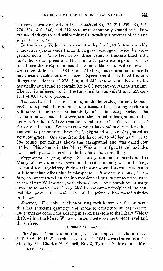
RADIOACTIVE: DEPOSITS IN NEW MEXICO 341
surfaces showing no torbernite, at depths of 80, 170, 214, 229, 239, 246, 278, 324, 510, 540, and 542 feet, were commonly coated with fine grained dark-green and white minerals, possibly a mixture of talc and serpentine or clay.
In the Merry Widow vein zone at a depth of 540 feet two weakly radioactive quartz veins 1 inch thick gave readings of twice the back ground count. Two feet below these veins, a fracture filled with amorphous dark-green and black minerals gave readings of twice to four times the background count. Similar black radioactive material was noted at depths of 278 feet and 510 feet, but no uranium minerals have been identified at these places. Specimens of these black fracture fillings from depths of 278, 510, and 542 feet were analyzed radio- metrically and found to contain 0.2 to 0.3 percent equivalent uranium. The granite adjacent to the fractures had an equivalent uranium con tent of 0.01 to 0.02 percent.
The results of the core scanning in the laboratory cannot be con verted to equivalent uranium content because the scanning machine is calibrated to measure radioactivity of sedimentary rocks. The assumption was made, however, that the normal or background radio activity for the rock is 380 counts per minute. On this basis, most of the core is barren. Seven narrow zones have radioactivity less than 150 counts per minute above the background and are designated as very low grade. One zone from depths of 540 to 546 feet gave 158 to 384 counts per minute above the background and was called low grade. This zone is in the Merry Widow vein (fig. 51) and includes two 1-inch quartz veins and a dark-colored fracture filling.
Suggestions for prospecting. Secondary uranium minerals on the Merry Widow claim have been found most commonly within the large eastward-trending Merry Widow vein zone where this zone cuts mafic or intermediate dikes high in phosphate. Prospecting should, there fore, be concentrated on the intersections of quartz-pyrite veins, such as the Merry Widow vein, with these dikes. Any search for primary uranium minerals should be guided by the same principles of ore con trol that govern the localization of the primary base-metal sulfides in the area.
Reserves. The only uranium-bearing rock known on the property that has sufficient quantity and grade to constitute an ore reserve, under market conditions existing in 1952, lies close to the Merry Widow shaft within the Merry Widow vein zone between the 60-foot level and the surface.
APACHE TRAIL CLAIM
The Apache Trail uranium prospect is an unpatented claim in sec. 2, T. 20 S., R. 15 W., a school section. In 1951 it was leased from the State by Mr. Charles N. Russell, Box 8, Tyrone, N. Mex., and Mrs.
354333 56 5
342 CONTRIBUTIONS TO THE GEOLOGY OF URANIUM
Elsie K. Wiley, 1451 South Oakhurst Drive, Los Angeles 35, Calif. The claim is accessible by vehicle by the following route: go 2.4 miles north from White Signal, N. Mex.; turn left (west) at gate onto an ungraded road: follow road for 2 miles to the Apache Trail prospect.
The claim was originally located for copper about 1890. Five cars of copper carbonate ore, averaging 5 percent copper and 5 ounces of silver per ton, were shipped between 1915 and 1920.
The original claim was abandoned and the present claim was located for gold in 1927. Bismuth, a common associate of gold in the district, was recognized at pit 5 (pi. 21) in a hematite-quartz vein, and 50 tons of ore, averaging 1 % ounces of gold per ton and 4 percent bismuth, were shipped. Bismuth in the ore is said to hinder concentration and smelting of other metals.
A 200-foot vertical shaft was sunk and 265 feet of drifts and cross cuts on the 100-foot level were driven in 1932. The bismuth gold vein was never found in these workings. The shaft is inaccessible below the 100-foot level. Prospect pits have been dug at several places along the hematite vein.
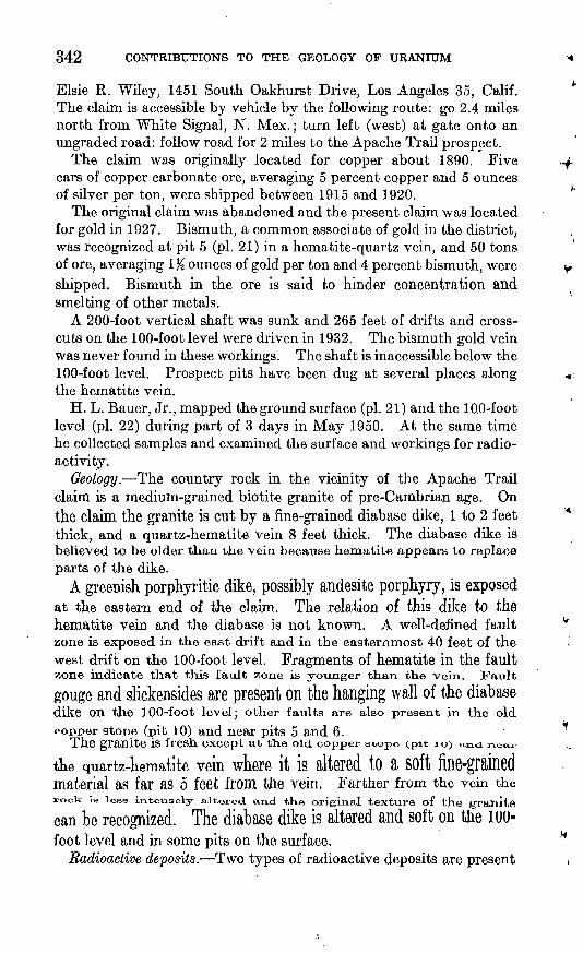
H. L. Bauer, Jr., mapped the ground surface (pi. 21) and the IQO-foot level (pi. 22) during part of 3 days in May 1950. At the same time he collected samples and examined the surface and workings for radio activity.
Geology. The country rock in the vicinity of the Apache Trail claim is a medium-grained biotite granite of pre-Cambrian age. On the claim the granite is cut by a fine-grained diabase dike, 1 to 2 feet thick, and a quartz-hematite vein 8 feet thick. The diabase dike is believed to be older than the vein because hematite appears to replace parts of the dike.
A greenish porphyritic dike, possibly andesite porphyry, is exposed at the eastern end of the claim. The relation of this dike to the hematite vein and the diabase is not known. A well-defined fault zone is exposed in the east drift and in the easternmost 40 feet of the west drift on the 100-foot level. Fragments of hematite in the faultzone indicate that this fault zone is younger than the vein. Fault
gouge and slickensides are present on the hanging wall of the diabasedike On the 100-foot level j other faults are also present in the old
copper stops (pit 10) and near pits 5 and 6.The granite is fresh except at the old copper stope (pit io> and near
the quartz-hematite vein where it is altered to a soft fine-grainedmaterial as far as 5 feet from the vein. Farther from the vein therook is less intensely altered and tKe original texture of the granite
can be recognized. The diabase dike is altered and soft on the 100- foot level and in some pits on the surface.
Radioactive deposits. Two types of radioactive deposits are present
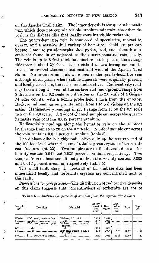
RADIOACTIVE DEPOSITS IN NEW MEXICO 343
on the Apache Trail claim. The larger deposit is the quartz-hematite vein which does not contain visible uranium minerals; the other de posit is the diabase dike that locally contains visible torbernite.
The quartz-hematite vein is composed of specularite, magnetite, quartz, and a massive dull variety of hematite. Gold, copper car bonate, limonite pseudomorphs after pyrite, lead, and bismuth min erals are found in or adjacent to the quartz-hematite vein locally. The vein is up to 8 feet thick but pinches out in places; the average thickness is about 3^ feet. It is resistant to weathering and can be traced for several thousand feet east and west of the Apache Trail claim. No uranium minerals were seen in the quartz-hematite vein although at all places where sulfide minerals were originally present, and locally elsewhere, the rocks were radioactive. Radioactivity read ings taken along the vein at the surface and underground range from 2 divisions on the 0.2 scale to 5 divisions on the 2.0 scale of a Geiger- Mueller counter with a 6-inch probe held 1 inch from the outcrop. Background readings on granite range from 1 to 5 divisions on the 0.2 scale. Radioactivity readings in pit 1 range from 15 on the 0.2 scale to 5 on the 2.0 scale. A 3%-foot channel sample cut across the quartz- hematite vein contains 0.012 percent uranium.
Radioactivity readings along the hematite vein on the 100-foot level range from 15 to 20 on the 0.2 scale. A 3-foot sample cut across the vein contains 0.011 percent uranium (table 5).
The diabase dike is highly radioactive only aj the western end of the 100-foot level where clusters of tabular green crystals of torbernite coat fractures (pi. 22). Two samples across the diabase dike at this locality contain 0.041 and 0.038 percent uranium, respectively. Two samples from diabase and altered granite in this vicinity contain 0.008 and 0.012 percent uranium, respectively (table 5).
The small fault along the footwall of the diabase dike has been mineralized locally and torbernite crystals are concentrated next to this fault.
Suggestions for prospecting. The distribution of radioactive deposits on this claim suggests that concentrations of torbernite are apt to
TABLE 5. Analyses (in percent) of samples from the Apache Trail claim
Sample no.
BJ-4-4.4-5.....4-0.....
4-7.....4-8.....
5-9.....
Location
.....do. ................
.....do....................
.....do...................
Material
.....do........ ............
granite.
ft thick......do........ ............
Equivalent ura
nium
0.033.017.011
.010
.013
.021
Ura nium
0.041.038.012
.008
.011
.012
Insoluble residue
12.44
21.73
Iron
68.67
42.03
Cop per
1.36
.82
344 CONTRIBUTIONS TO THE GEOLOGY OF URANIUM
occur within the diabase dike where it is fractured or where it has been cut by faults and veins. Radioactivity of gossans along the quartz vein may indicate the presence of primary uranium minerals in the vein below the zone of oxidation.
BLUE JAY CLAIM
The Blue Jay claim is about 400 feet west of a dirt road which joins New Mexico Highway 180 at White Signal. The claim is about three-fourths of a mile south of White Signal (fig. 50). The quarter- section corner of the boundary between sees. 23 and 26, T. 20 S. r R. 15 W. lies within the claim boundaries. The claim was located in 1949 by Otto and Fred Prevost, of White Signal and Silver City, respectively, and was leased to E. B. Killion of Silver City, N. Mex., in 1950. Granger and Bauer examined the radioactive deposits on the Blue Jay claim in March 1950 and mapped the area containing radioactive deposits (pi. 23) by planetable using a scale of 1 inch equals 30 feet. Forty-four samples were taken; both radioactive and barren rocks were sampled and assayed for P205 as well as ura nium. The White Signal district had been examined previously by the Union Mines Development Corporation (Keith, unpublished reports, 1944, 1945a), but this examination did not include the Blue Jay claim.
Before the examination by Granger and Bauer, Mr. Killion had removed the overburden from, four localities on the claim by bull dozer. These localities were selected by him on the basis of abnormal radioactivity detected with a portable Geiger counter. No ore had been produced.
Geology. The Blue Jay claim is underlain by a large mass of pre- Cambrian granite cut by a variety of dikes.
The granite that forms the country rock in the vicinity of the Blue Jay claim. is typically a leucocratic biotite-poor medium-grained rockin which the feldspars are partly argnnzed.
A diabase dike, cut by other intrusive rocks and faulted, trends^oi-tKwesfc across the Blue Jay claim. Rock mapped as diabase in the northwestern bulldozer cut is intonseiy ^u^a, friable, and locally bleached or Iron stained. The diabase surrounding a 10-foot pit nearthe western margin of the area is oieacned noai-v ~k;u and is cutby paper-thin veinlets containing specxilarite and Slderite(?).
A dftFk-OTfty fifl6'£Jamed ^ike, abOUt 7 feet wide, which is believea
tO Se basalt; Strikes northwest nearly parallel tO tuG diflbfllSCi
Two bodies of altered intrusive rock are tentatively identified as latite beCaUSe they are similar in habit and general appearance tounaltered latite outside the mapped area. These bodies hare an
RADIOACTIVE. DEPOSITS IN NEW MEXICO 345
easterly trend and are separated by rhyolite dikes. They may have originally been part of a more extensive dike or plug.
A thoroughly fractured friable aphanitic dike about 8)2 feet wide is exposed in the northernmost bulldozer trench. It strikes about N. 80° E. and dips vertically. A 1- to 6-inch dike of similar material is exposed in a shallow pit 40 feet west of this trench. The minerals and the texture of the original rock have been destroyed by intense alteration.
A large white-to-gray rhyolite dike trends eastward across the area mapped and dips about 70° S. In the eastern part of the area (pi. 23) this dike contains four small inclusions of granite.
Most of the faults on the Blue Jay claim are occupied by dikes or veins. Where the faults are unmineralized they are obscure and display little brecciation or marginal fracturing. Two types of veins occupy the faults: specularite veins and quartz-pyrite veins. A persistent specularite vein, % to 2 inches wide and about 260 feet long, trends about N. 70° E. and dips steeply northward. Other specularite veins are short and very narrow.
Most of the veins are filled with limonite and sparse quartz and are bordered by argillized and, less commonly, by sericitized wall rock. These are believed to be oxidized quartz-pyrite veins.
Uranium deposits. The uranium deposits on the Blue Jay claim are most commonly found in intermediate or basic dikes near oxidized quartz-pyrite veins. Two secondary uranium minerals have been found in the deposits. One is a tabular green nonfluorescent mineral, probably torbernite; the other, which was not identified, is a yellow powdery mineral with weak yellow fluorescence. Torbernite coats fracture surfaces in the rock at sample localities HLB-15-137, -159, -163, -170, and -176 (pi. 23). At sample locality HLB-15-177 the torbernite coats fracture surfaces in granite and the contact between a quartz vein and argillized feldspar. The yellow secondary uranium mineral, as a dull amorphous powder, coats innumerable fracture surfaces in the larger aphanitic dikes. The prevalence of this mineral in the dikes makes these rocks the richest sampled, containing up to 0.11 percent uranium (table 6).
Although no uranium minerals were seen in several of the samples containing an abnormal amount of uranium, the radioactive samples, rock and vein material, are very iron stained in most places, suggesting that the uranium may be associated with hydrous iron oxide.
Nearly all the samples that contain more than 0.01 percent uranium were taken from altered mafic rock near quartz-pyrite veins. The samples that are exceptions to this generalization were taken from material.in the quartz-pyrite veins, which are very iron stained in places, or in fractures near granite. The intense iron stain, which is
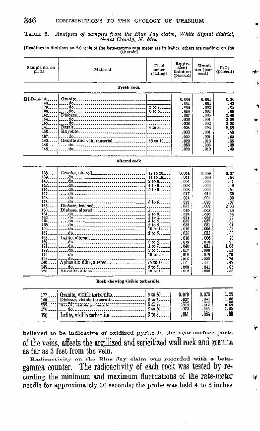
346
TABLE 6. Analyses of samples from the Blue Jay claim, White Signal district,Grant County, N. Mex.
[Readings in divisions on 2.0 scale of the beta-gamma rate meter are in italics; others are readings on the0.2 scale]
Sample no. on pi. 23 Material
Field meter
readings
Equiv alent
uranium (percent)
Urani um (per
cent)PjOs
(percent)
Fresh rock
HLB-15-151..... 153 179 180 152 154.....155 141..... 150 157 143 145 -148
Granite.. __________________ do...... ...................... do.....-.-....................-... .... ..do ..
..do ... ...... ...... ......... .do.. ...............................Basalt. _______ . ...Rhyolite _______________
.....do.... ..... .. .....................Granite and vein material. _______ .. do. ................................. do... . .... ....... ............
2 to 7 Oto5...-
4 to 8 -
13 to 16
0.004 .001 .no4.004 .007 .003 .003 .004 .003 .002 .020 .050 .020
0.001 .001 .002 .001 .005 .001 .002 .003 .001 .001 .013 .035 .010
0.36 .43 .65 .60
2.86 2.95 2.93 2.58 .48 .50 .35 .39 .43
Altered rock
138 139 140 142 144 147 158 178 ..156 160 161. _ .162 .....164.....165 166 ..167 168 169 171 172 174
HO..... 149 173 -
Granite, altered ______________. ao ... . .............. .......... do... .................................. do...... ...... ..................... do..... ..............................do...... .... ........................... do . . - . ......do ..............................Diabase, leached ____ __ .. .......Diabase, altered. .......................... do... .......... ...... .............-.-..do--......-.. ______ .. ____ ... .. do ............ ...... ................- .do................. ....................... ..do...... . . _.....do ............ ..................Latite, altered .do do ....... ................ ........... .do ..do______.......... ..........
Aprianitic dike, altered....... ..... ............do.................... .................RhyoHte, altered-- _ __ _ _ _ _-__ - - _ __
12 to 20 11 to 18- 2 to 6 .4 to 9 .5 to 9 ...
Sto5
S... .......
2to5 10 to 14 StoB......
J8to5 4 to 7 ..2 to 5 . ..10 to 20
16 to 17.... eto8 1O to 15- -
0.014 .011 .004 .008 .008 .017 .004 .023 .003 .010 .028.024.039 .036 .010 .036 .010 .019 .040 .017 .018.016.17 .060 .012
0.009 .006 .003 .006 .009 .010 .001 .020 .002 .008 .020.028 .037 .031 .005 .035 .006 .018 .031 .009 .016.009 .11.041-OOC
0.37 .64 .41 .43 .54 .35 .30 .37
2.93 .49 .56.69 .62 .91 .53 .60 .70 .95
1.03 .63 .79.76.49.85.36
Rock showing visible torbernite
177 159 137 176 170
Granite, visible torbernite.-. ...........Diabase, visible torbernite-
.... do ............ ............ ......Latite, visible torbernite..... ...... ... .. ..
5 to 20.... .5 to 7
5 to 80.. Sto8......
0.079.037.036 .018
.079
.051
0.076.041 .042 .017 .085.064
1.29 1.00.80
2. 58
1.65 .90
believed, to be indicative of oxidized pyrite in the near-surface parts
of the veins, affects the argillized and sericitized wall rock and granite as far as 3 feet from the vein,
Radioactivity on the Blue Jay claim -was recorded with, a beta-
gamma counter, The radioactivity of each rock was tested by re cording the minimum and maximum fluctuations of the rate-meterneedle for approximately 30 seconds; the probe was held 4 to 5 inches
RADIOACTIVE. DEPOSITS IN NEW MEXICO 347
from the rock surface. The average reading for most of the relatively unaltered rocks was about 1 to 7 divisions on the 0.2 scale. This corresponds to about 0.001 to 0.003 percent uranium in samples taken nearby.
Forty-four samples were collected during the examination. Chan nel samples were cut in most areas of abnormal radioactivity; several grab samples were taken in relatively unaltered rock of minimum radioactivity. Minimum and maximum rate-meter readings were recorded for many of the samples (table 6) with the probe held about 1 inch from the rock.
On the Blue Jay claim both granite and rhyolite normally contain 0.001 to 0.002 percent uranium. Within a few inches of fractures and veins the granite may contain several times this amount. A sample of weathered granite with torbernite was submitted by the owner and found to contain 0.083 percent uranium. Basalt and dia base contain about 0.001 to 0.005 percent uranium except within or near fractures and veins where they may contain as much as 0.085 percent. The intensely altered latite contains from 0.006 to 0.064 percent uranium. All aphanitic dikes are altered and contain as much as 0.11 percent uranium. The total area of uranium-bearing rocks on the Blue Jay claim is small. The aphanitic dike that is 3% feet thick is about 90 feet long, as determined by abnormal radioactivity in the soil along the indicated strike. Uranium content of the diabase in the bulldozer cut located in the northwestern part of the area (pi. 23) is abnormally high. The highest uranium concentration in this diabase is in an area about 25 feet square where the diabase is cut by an iron-stained vein or fracture.
Although the latite apparently has a high uranium content every where, the richest uranium concentrations in this rock are along an iron-stained fracture zone in the southwestern bulldozer cut.
Suggestions for prospecting. The results of sampling indicate that no large deposits of uranium ore are available. If prospecting is done, it should be concentrated along the intersections of intermediate and basic dikes with quartz-pyrite fissure veins and along the radioactive aphanitic dike exposed in the northwestern bulldozer cut.
Reserves. Results of sampling suggest that at 6 localities the uranium-bearing rock on the property contains between 0.01 and 0.05 percent uranium. The largest deposit is in and along the aphanitic dike in the northern bulldozer cut (pi. 23).
MONARCH NO. 2 CLAIM
The Monarch No. 2 claim is in sec. 19, T. 20 S., R. 15 W., about 4 miles west of the settlement of White Signal, and was owned by C. E. Russell, White Signal, N. Mex., in 1950 (fig. 50). A brief exam ination of the claim was made by H. L. Bauer, Jr., on May 22, 1950.
348 CONTRIBUTIONS TO THE GEOLOGY OF URANIUM
A milk-white rhyolite dike, which strikes N. 45° E., cuts granitic country rock on this claim. A massive quartz vein parallels the dike, which locally has been silicified and is cut by quartz stringers. Frac ture surfaces in the dike are stained by limonite.
A prospect pit, 15 feet long and 2 feet deep, has been excavated in the rhyolite dike. A few autunite crystals were observed in the rhyolite, but none could be seen on the fracture surfaces. The radio activity of the rhyolite caused a deflection of 5 to 15 divisions on the 0.2 scale of a counter. The quartz vein was not radioactive. A grab sample, BJ-7-14, was taken from the dump and found to contain0.011 percent uranium,
The Money Maker and Wild Irishman claims are southwest of the Monarch No. 2 claim; they include the same rhyolite dike and associ ated massive quartz vein but show no abnormal radioactivity.
TUNNEL SITE NO. 1 CLAIM
The Tunnel Site No. 1 claim (fig. 50) is in the SE^NEX sec. 26, T. 20 S., R. 15 W. and is reached by about IK miles of graded dirt road that turns south from State Highway 180 at White Signal, N. Mex.
The claim was owned by E. B. Killion of Silver City, N. Mex., when it was examined briefly by H. C. Granger and H. L. Bauer, Jr., on April 1, 1950. Development work consisted of a discovery shaft 10 feet deep and a 250-foot adit approximately 75 feet west of the shaft. Two winzes, 20 and 40 feet deep, were sunk about 90 feet and 110 feet, respectively, from the portal of the adit. Short crosscuts branch from the adit near the face.
The rocks on the claim are medium-grained gray pre-Cambriangranite cut by greenish-gray rhyolite dikes. The discovery shaft was
sunk in bleached argilKzed granite near a rhyolite dike, Clay veins,1 to 4 inches thick, that have no preferred orientation cut both the
granite and rhyolite in and near the shaft. The clay appears to be ofthe kaolin type and contains no metallic minerals. Limonite-stainedcavities in the veins may indicate the former presence of disseminated pyrite.
The adit, which was driven N. 30° E., along a granite-rhyolitecontact, cuts several faults and vein zones. The veins cut by the adit a.T-6 about 1 to 2 inches thick and are slightly iron stained,' they appear tO foe OAidized quartz-pyrite veins.
TKe sKa,ft a-nd adit were traversed with a field COUntfir. All 111685-
urements were made with the probe beta shield open. The radio-activity on the surface averaged about 5 divisions orx tKe 0.2 scale in
the shaft and throughout the adit. An area 2 M high and 3 feetlong on the west wall, about 45 feet from the .portal of the adit, was abnormally radioactive. When the probe was placed on the wall,
RADIOACTIVE DEPOSITS IN NEW MEXICO 349
a maximum deflection of 7 was noted on the 2.0 scale. A channel sample the length of the radioactive zone assayed 0.018 percent equiva lent uranium and 0.001 percent uranium. The reason for this appar ent disequilibrium is not known.
UNCLE SAM SILVER MINES
The Uncle Sam silver mines are in sec. 32, T. 20 S., R. 14 W. (fig. 50). They were visited in March 1950 by H. L. Bauer, Jr. The ownership of the properties is not known.
The mines are a series of abandoned shafts, adits, stopes, and pros pect pits extending for about half a mile along a shear zone in pre- Cambrian granite. The shear zone ranges from 1 to 6 feet in width, trends N. 40 0-45°W., and dips 70°-85° SW.
Quartz and sulfide minerals fill fractures in the shear zone which is marked by 2 to 6 feet of iron-stained granite.
Abnormal radioactivity was noted in some specimens of sulfide- bearing vein material from a dump. These specimens gave readings of 8 to 12 divisions on the 0.2 scale of a survey meter when the probe was placed in contact with the vein material. The background was 5 divisions on the 0.2 scale. At the portal of an adit 500 feet southeast of the main shaft a silicified fracture 1 foot wide registered 10 to 12 divisions on the 0.2 scale. A 2-inch limonite vein, in a small pit about 1,500 feet northwest of the main shaft, registered from 2 to 5 divisions on the 2.0 scale. No samples were taken at the abnormally radioactive areas because of their small size and relatively low radio activity.
BLACK HAWK DISTRICT
By H. C. GRANGER AND H. L. BAUER, JR.
The Black Hawk district is in sees. 20, 21, 28, and 29, T. 18 S., R. 16 W., New Mexico principal meridian, and is about 20 miles by road from Silver City, N. Mex. (fig. 50). The district is reached by a dirt road that extends south from U. S. Highway 260 about 13 miles north west of Silver City.
On March 19, 1950, the authors made radioactivity traverses of the Black Hawk mine dump and dumps from other mines on the same vein. Rocks along Black Hawk Canyon were tested as far south as 2 miles from the Black Hawk mine.
Additional information was compiled from the files of the U. S. Bureau of Mines in Silver City, N. Mex.
The silver deposits of the Black Hawk district were discovered in 1881 and $1.5 million worth of silver was produced in 7 .years. About half of this amount came from the Black.Hawk mine; the remainder came from the Alhambra, Rose, and Hobson mines, all within a mile of the Black Hawk mine. Mining ceased in 1893 and
854333 66 6
350 CONTRIBUTIONS TO THE GEOLOGY OF URANIUM
TABLE 7. Samples from the Black Hawk district, collected and assayed by theU. S. Bureau of Mines
Locality
Rosfi mfnfi dumpAlh^mhra mlnn dump
Ni (percent)
0.07.18
Co (percent)
0.08.10
Ag (oz/ton)
10.5534.70
Au (oz/ton)
0.06.02
the mines remained idle until 1917 when the Black Hawk mine was reopened for exploration. Reports do not show that any ore was mined at this time. After 1918 there was little activity in the district, although Leach (1920, p. 989) mentions pitchblende from the Black Hawk district.
In 1948 the U. S. Bureau of Mines became interested through Albert A. Leach, owner of the Alhambra mine, who submitted old reports on the mines and also several specimens that contained silver, nickel, cobalt, and uranium (pitchblende). The Bureau made a brief examination of the district on July 24, 1948, and collected two samples (table 7) which were not assayed for uranium.
Geology. According to an unpublished report (1918) on the Black Hawk mine by Weed, the oldest rock near the mine is a coarsely porphyritic gneiss of probable pre-Cambrian age. This rock contains large feldspar crystals in a groundmass of biotite and, locally, quartz. The gneiss is cut by aplitic dikes that grade into feldspar pegmatites. Dikes related to a large intrusion of monzonite porphyry are present near the Black Hawk mine.
According to Weed (unpublished report, 1918), pink granite, dark quartz diorite, and a rhyolite dike are found near the Black Hawk mine. He further states that monzonite porphyry and gneiss were found in the mine and that both rocks are cut by carbonate veins; but only in the gneiss are the veins ore bearing,
Ore deposits The veins in the Black Hawk district are well defined at fresh exposures but are rather inconspicuous in exposures at the surface. They cut the rocks within an area of nearly 4 square miles.
According to an unpublished report by A. A, Leach (1917), theganglie iH the Vein IS COmpOSed Of partly silicified carbonates. Thesilicified gangue is commonly a fine-grained jasperoid. Pyrite, galena, sphalerite, and chalcopyrite are associated m the vein with niccolite, nickel skutterudite, smaltite (cobalt skutterudite), native silver, and argentite.
Fitcnmende has been reported in the Black Hawk and Alhambramines, and the Black Hawk dump was carefully examined for vein material, but a few specimens Of Carbonate gangue containing small amounts of metallic sulfides were all that COUld be found.2
1 Pitchblende has been definitely identified in specimens from dumps in the Black Hawk district as a result of more recent work by Elliot Gillerman and D. H. Whitebread, of the Geological Survey.
RADIOACTIVE DEPOSITS IN NEW MEXICO 351
The presence of cobalt-, nickel-, and silver-bearing minerals in a gangue of carbonates and silicified carbonates indicates a similarity between the mineral assemblage in the Black Hawk district and that hi many deposits known to contain pitchblende.
Radioactivity. In July 1949 the engineers of the U. S. Bureau of Mines examined the dump of the Alhambra mine with a Geiger counter. They found that one small pile of ore was slightly radio active. The Bureau also tested several specimens of cobalt-nickel ore from the Alhambra mine which had been submitted by Albert A. Leach. One specimen was found to be very radioactive, probably because of the presence of pitchblende.
Granger and Bauer tested a specimen of native silver from the Black Hawk mine, owned by Ira Wright, Silver City, N. Mex. The specimen, about 60 to 80 percent native silver, registers 15 divisions on the 2.0 scale of a field counter. The average background was about 4 divisions on the 0.2 scale.
No radioactivity over twice normal background was observed on the Black Hawk or nearby dumps along the Black Hawk vein. One small dump about a mile south of the Black Hawk mine, on the west wall of the canyon, registered 10 divisions on the 0.2 scale. The country rock showed no abnormal radioactivity.
BLACK HAWK MINE
The Black Hawk property consists of 14 claims, 8 of them patented. In 1950 it was owned by the Black Hawk Consolidated Mines Co., Milwaukee, Wis. Ira Wright, of Silver City, N. Mex., was general manager.
The mine includes 4 vertical shafts and 1 inclined shaft, all caved and inaccessible. According to old reports, the main shaft extends from the surface to the eighth level, 450 feet below the surface, and a winze on the eighth level extends 150 feet deeper; the total depth is 600 feet.
The vein is exposed on the second level for 434 feet to the east and 80 feet to the west of the shaft.
The Black Hawk mine is reported to have produced $650,000 in silver between 1881 and 1889.
AIHAMBKA MINE
The Alhambra mine is on a group of 5 patented and 3 unpatented claims owned, in 1950, by Albert A. and Frances 1. Leach, Lordsburg, N. Mex. The main shaft is reported to be 400 feet deep, and the mine contains several hundred feet of horizontal workings.
Records show that the Alhambra mine produced $400,000 in silver before 1893.
352 CONTRIBUTIONS TO THE GEOLOGY .OF URANIUM
ROSE MIWE
The Rose mine is on a patented claim owned, in 1950, by Mrs. Elizabeth J. McCabe, Pasadena, Calif.
It is reported that the main shaft is 200 feet deep and that there are levels at 50, 100, 150, and 200 feet. At present, these workings are caved and inaccessible.
Past production is reported to be $140,000 in silver.
OTHER DEPOSITS
BINES HO, i PEOSPECT
The Hines No. 1 prospect is in the NE$ sec. 34, T. 21 S., R. 14 W., about 13 miles by road southeast of White Signal (fig. 50). The deposit was discovered by Joe Frost and Charles Russell, of Tyrone, in March 1950. The property may be reached from White Signal by traveling 1.5 miles east along the White Signal-Whitewater road and then turning south to the Royall Ranch. Beyond the ranch the road is indefinite and inquiry should be made for directions to the property.
Development consists of two pits. The deposit was examined by Harry C. Granger, Herman L. Bauer, Jr., and Elliot Gillerman in April 1950; it was re-examined and mapped by Elliot Gillerman in June 1950 (unpublished report).
The Hines deposit is in Bliss (?) sandstone of Cambrian age. The exposure is 250 to 300 feet wide and is surrounded by alluvium on all but the northwest side where it is in fault contact with pre-Cambrian granite. This fault strikes N. 30° E. and seems to dip steeply north west.
The Bliss (?) sandstone in this vicinity consists of medium-grained well-cemented silicified white quartzite, grayish-green ferruginous quartzite, gray quartzite, sandstone, and a bed of brown medium- grained limestone 10 feet thick, which contains gastropod fragments,These rocks strike northwest and dip steeply to the northeast near thetwo pits. A small northwestward-trending fault cuts the sedimentary
rocks a short distance north of the pits (fig. 52).Fluorite and autunite(?) are present in quartzite breccia along a
nearly vertical shatter zone that strikes N. 85° E. A subsidiary breccia zone, which strikes N. 50° W., branches southeastward fromthe main zone. Scheelite occurs in a similar breccia zone that strikesabout 3ST. 75° E. It is close to, but not contiguous with, the fluorite-
ailtunite zone, The fluorite is white, violet, or dark purple; it is
found as fissure fallings and matrix in the breccia in pit 2. Rare smallcrystals of a yellow fluorescent material, tentatively identified asaUtUflite, coat fracture surfaces on the c^uartzite in pit 2, but tbe-^ ai-o
generally not closely associated with the fluorite. No radioactive material was found in pit 1.
RADIOACTIVE DEPOSITS IN NEW MEXICO 353
.EXPLANATION
Overburden
Diabase dike
Granite
Bliss(?) sandstone
Contact, dashed where approximately located
Inferred contact
Fault showing dip, dashed where approximately located
Strike and dip of beds
Geology by Elliot Gilterman, June 1950
FIGURE 52. Geologic sketch map of the Hines No. 1 prospect, Grant County, N. Mex.
The time when mineralization occurred is unknown; the paragenetic relation of the fluorite and the autunite(?) are inconclusive, but the autunite(?) appears to be later.
Radioactive breccia exposed in pit 2 gave a maximum reading of 5 divisions on the 2.0 scale of a beta-gamma counter. Two channel samples across the breccia zone, one in the east end and one in the west end of pit 2, both contained 0.004 percent uranium (table 8). A grab sample, submitted by the owner, assayed 0.027 percent equivalent uranium.
IANGFORD PROSPECT
The Langford prospect is in the S^ sec. 25, T. 22 S., R. 16 W., about 23 miles by road south of White Signal; it can be reached by driving 19.5 miles south from White Signal on the Separ road and then turning
354 CONTRIBUTIONS TO THE GEOLOGY OF URANIUM
TABLE 8. Analyses of samples from the Hines No. 1 prospect, Grant County,N. Mex.
Sample no.
HLB-14-134 -
135.
136....
Locality
Pit 2.. .
.....do.....
Pltl......
Description
Quartzite breccia and fluorite. Channel sample 1.5 ft long.
ft long.
Equivalent uranium (percent)
0.005
.006
.001
Uranium (percent)
0.004
.004
.001
west for 3.5 miles on a dirt road to the prospect (fig. 50). This deposit was discovered by Charles Russell, of Tyrone, and was undeveloped in 1950. It was examined and mapped by Elliot Gillerman in April andJune 1950 (unpublished report).
The deposit is in a silicified breccia zone cutting fine-grained grayish- pink pre-Cambrian granite. Many pegmatite dikes, 2 inches to 2 feet wide, are found in the granite; south and southeast of the deposit rhyolite and diabase dikes cut the granite also.
Two ore minerals are present; a dark-purple fluorite and a yellow uranium mineral, possibly autunite, associated with pink calcite in the silicified breccia zone. The breccia is exposed in a fault for about 150 feet along the north bank of a small creek. The fault strikes N. 35° W. and dips 65° SE. The fluorite and autunite (?) are limited to the middle 50 feet of the exposure, but pink calcite is found along the entire exposed length of the fault. The vein minerals are present throughout the 2>z- to 3^-foot zone of breccia but are most concen trated on the footwall side of the fault. Fluorite is found as tiny violet to dark-purple crystals in veinlets less than half an inch wide. The bright-yellow autunite (?) lines cavities in the breccia less than 5 mm in diameter. The dark-purple fluorite was found to be radioactive.
The radioactive breccia zone gave a maximum reading of 5 divisionson the 2.O scale of a beta-gamma counter.
REPORTED OCCURRENCES
The following reported uranium occurrences in Grant County havenot yet been studied by the U. S. Geological Survey and are not included in this report: many small deposits in the White Signal
district, some of which are included in the unpublished report by Keith (1945a); torbernite from the Chino disseminated copper pit
Mountains; and radioactive xenoliths in Tertiary lavas in LittleGallinas Canyon in the Black Range. Two samples of cherty mate rial from Little Gallinas Canyon were submitted by C. H. Rogers tothe U. S. Geological Survey for analysis. They contained 0.068 and 0.016 percent uranium, respectively.
RADIOACTIVE: DEPOSITS IN NEW MEXICO 355
LITERATURE:.;*
The ore deposits of the White Signal and Black Hawk districts aredescribed briefly in U. S. Geological Survey Professional Paper 68 (Lindgren, Graton, and Gordon, 1910, p. 321-324), but the discussion is limited to the gold, silver, and base-metal deposits. The general geology and mineral deposits (exclusive of uranium) of the White Signal district have also been discussed by Sidney Paige in U. S. Geological Survey Geologic Atlas, folio 199 (1916).
The first published reports dealing with uranium in these districts are by F. I. Leach (1920) and Granger and Bauer (1952). Each of these reports describes in detail a small area, usually a single property.
LEA COUNTY
The following information was abstracted from an unpublished report by R. P. McNeal (1950a).
Abnormal radioactivity has been detected in several of the oilfields of Lea County in southeastern New Mexico (fig. 49, deposit 23). These fields, including the Hobbs, Monument, Cooper, and Jal, are along the western edge of the central basin platform bordering the Delaware basin.
Production in these fields comes from the San Andres, Big lime (of drillers), and Seven Rivers formations, all of Permian age. The depth of producing strata ranges from 3,300 to 4,100 feet.
The positions of the radioactivity anomalies, as represented on some gamma ray logs by extremely high deflections, correspond closely to the positions of the producing strata. A precipitate which lines the tubing in some wells is strongly radioactive. Radioactivity anomalies have been noted only in those wells that produce water with the oil. All available evidence indicates that the radioactive elements were transported by water.
Localization of the radioactive fields along the west edge of the central basin platform and the fact that the oil production of the radioactive wells is from Permian formations suggest a possible rela tionship of radioactivity to the Permian evaporites in the Delaware basin to the west.
MORA COUNTY, COYOTE CREEK
The following information has been taken from an unpublished report by G. B. Gott and R. L. Erickson (1951) and from U. S. Geological Survey Circ. 334 by H. D. Zeller and E. H. Baltz (1954).
Copper-uranium-bearing black shale and sandstone of the Permian Sangre de Cristo formation are exposed 2 to 3 miles south of Guada- lupita on Coyote Creek (fig. 49, deposit 10). The abnormal radio activity of the shale was first discovered in 1951 by Charles B. Read
356 CONTRIBUTIONS TO THE GEOLOGY OF URANIUM
and George O. Bachman, of the U. S. Geological Survey. The shale is about 5 feet thick, dips nearly vertically, is nonmarine, and is overlain and underlain by arkosic sandstones. The deposits are in lenticular carbonaceous zones in both shales and sandstones. Chalcocite, pyrite, and malachite are abundant. Uraninite from copper sulfide nodules in the black shales has been identified, and tyuyamunite is disseminated in some of the arkosic sandstones. Zeller and Baltz (1954) conclude that copper and uranium were syngenetically deposited with the sediments and concentrated in the carbonaceous zones during lithification. They report that samples from some of the zones contain as much as 0.67 percent uranium and average 3 percent copper.
RIO ABRIBA COUNTY
Uranium minerals are present in many different places in Rio Arriba County. In the mountains, along the eastern border of the county, near the town of Petaca, samarskite is found in pegmatites cutting pre-Cambrian schist. A few miles south of Coyote, black shales of Jurassic age show abnormal radioactivity. Two copper districts at Jarosa and at Cobre basin, in the western part of the county, contain radioactive plant remains associated with copper minerals in sandstones of Permian and Triassic age.
PETACA PEGMATITE
Hess and Wells (1930) reported a samarskite-bearing pegmatite 2% miles southwest of the town of Petaca (fig. 49, deposit 9). At the time of their examination this land belonged to Charles Springer, of Cimmaron, N. Mex. The claim was located for mica and included one of a group of pegmatites that extends about 14 miles north and south. These pegmatites strike northwest and dip southwest roughly parallel to the schistosity of the pre-Cambrian quartz-mica schistwhicH they intrude.
Within the pegmatite large masses of pink microcline as much as 10 feet in diameter are associated with vein quartz, white micro-cline, and muscovite in books up to 18 inches thick. The radio-actixre minerals replace tlae micx-ocline. Ttie minerals consist of masses
of samarskite, ranging in size from microscopic grains up to piecesan inch thick, and of imperfect crystals and larger masses of a dull-
reddish monazite. OTTOTC ^^^^^^
The information on this and the following three deposits has been abstracted from an unpublished report (1951) by G. 0. Bachman and C. B. Read.
A radioactive carbonaceous shale member of the Jurassic Todilto limestone crops out on a high mesa 4 miles south of the town of Coyote
RADIOACTIVE DEPOSITS IN NEW MEXICO 357
(fig. 49, deposit 6). The equivalent uranium content of this shale is estimated at 0.005 percent.
COPPER CITY GROUP
The Copper City group of prospects is in a coarse sandstone member of the Triassic Chinle formation in the southern part of the county, approximately 7 miles east of Cuba (fig. 49, deposit 7). Copper carbonates and sulfides associated with carbonized plant remains have been mined on this property. This organic matter contains an estimated 0.006 percent equivalent uranium. The copper content averages 1 % percent.
JAROSA DISTRICT
Twenty-five miles east of Cuba, in the Jarosa district on the eastern flank of San Pedro Mountain (fig. 49, deposit 8), copper minerals have been found at several places in the Cutler formation of Permian age. The prospects are in a radioactive zone about 4 feet thick and contain carbonaceous material. This zone is estimated to contain about 1 percent copper and 0.006 percent equivalent uranium.
COBRE BASIN GROUP
Cobre basin is in the southeastern part of the county 7 miles northeast of Abiquiu (fig. 49, deposit 5). Radioactive low-grade copper-ore bodies are found in a coarse sandstone of the Triassic Chinle formation. The radioactive material is localized by carbonized plant remains. The equivalent uranium content of these deposits is estimated at 0.005 percent and the copper content at 0.8 percent.
LITERATURE
The first published report on uranium-bearing material from Rio Arriba County was issued in 1930 by Hess and Wells (1930, p. 17-26) on the pegmatites near Petaca. This report is primarily about mineralogy and about the laboratory methods employed by the authors to ascertain the age of the pegmatite by determining lead-uranium ratios on the samarskite. An article by L. R. Page (1950) in Economic Geology also discusses these deposits. A reconnaissance report by Bachman and Read (unpublished, 1951) briefly describes radioactive spring deposits, coal and black shale, and sandstone copper deposits in Rio Arriba and Sandoval Counties.
SANDOVAL COUNTY
Sandoval County, in north-central New Mexico, just south of Rio Arriba County, contains many different radioactive deposits, all of secondary origin. Radioactive coal and black shale are found near San Ysidoro and on La Ventana Mesa. Hot spring waters are
358 CONTRIBUTIONS TO THE GEOLOGY OF URANIUM
depositing radioactive tufa at Jemez Springs and Caseman well. A short distance from Jemez Springs a sedimentary copper deposit, known as the Spanish Queen group, is associated with uranium- bearing carbonized plant remains. The Perry Robb spring deposits near Jemez Springs were studied in detail by Granger (unpublished report). Many of his conclusions about them may have wider applications; hence these deposits are discussed in some detail. The available information on the other deposits in the county is much more limited, and they can only be described briefly in this report.
RADIOACTIVE SPRING DEPOSITS, PERRY ROBB PROPERTY, JEMEZ SPRINGS
By H. C. GRANGER
A radioactive thermal spring deposit near Jemez Springs, Sandoval County, N. Mex., was brought to the attention of the U. S. Geological Survey by Mr. Perry Robb in January 1950. The deposit is along the Jemez River in sec. 14, T. 18 N., R. 2 E., New Mexico principal meridian (fig. 49, deposit 12). It may be reached by going north 1.7 miles from Jemez Springs on a graded dirt road, State Highway 4.
The thermal spring deposits are in the valley of the Jemez River. The valley is a sharply incised canyon 1,700 feet deep; the valley floor is less than 1,000 feet wide and the canyon runs are about 2 miles apart. One of the springs has formed an elongated deposit (fig. 53) of calcareous tufa across the valley that has partly dammed the Jemez River. This deposit is a local scenic attraction and is called the Soda Dam. The Soda Dam and surrounding deposits were exam ined by the author in April 1950. A sketch map on a scale of 1 inch equals 100 feet was made (fig. 53); 5 samples of calcareous tufa, 4 ofthermal spring waters and 1 sample of river water were collected.
General Geology. The oldest rock in the area, a medium-grainedpre-Cambrian granite with red feldspar, is exposed along the floor of the Jemez River valley. This granite underlies 700 feet of Paleozoic limestone, sandstone, and shale of the Pennsylvania!! Magdalena group and Permian Abo sandstone. The rocks are exposed as apparently flat-lying bedS alODg bOth Walls Of the Jemez River vaUey. They are capped by volcanic rocks ranging in composition from rnyollte to andesite of Cretaceous to Quaternary age. The most recent rocksare thermal spring deposits Of calcareous tufa. Springs emit water ranging from 10° to 70° C.
Radioactivity. ]VIost of the deposits left by tke thermal SpriDgS
are Of White radioactive porous calcareous tufa, but some contain
massive travertine and rarely pisoKtiC Calcite. NORF th8 CanjOIlwalls tufa commonly contains fragments of talus which fell while the deposit was being formed. Locally the white tufa contains a black sooty radioactive material. These black areas are commonly less
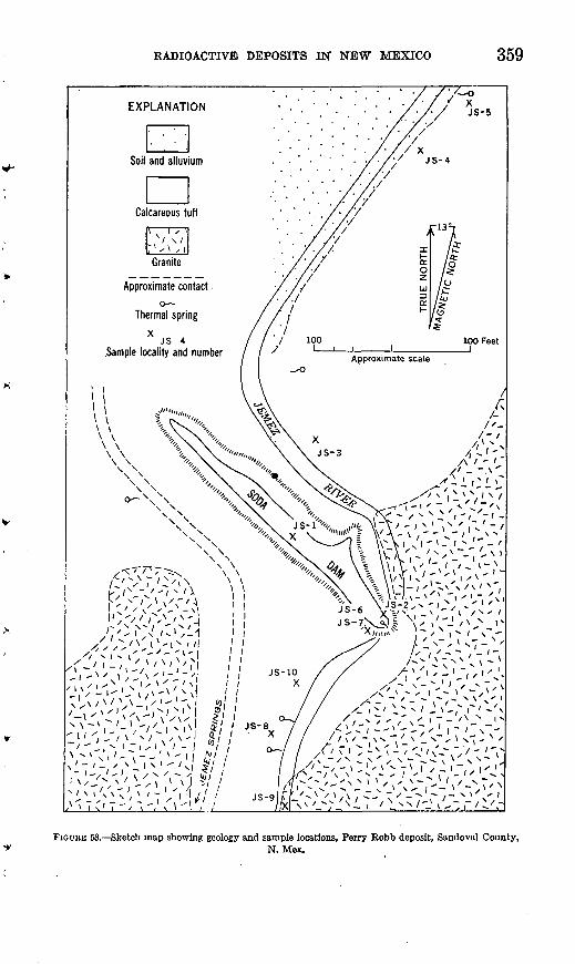
RADIOACTIVE DEPOSITS IN NEW MEXICO 359
'-''t- ^~'x''\' i! *N \ ~\ '-' -/' | v ,\l £/ ' JS-8^'-LON^',-',^! # / ' "_., x I -\s\ N I - '°/ / (
'/Vi-'v-:^,^ 1 / ^//
FIOUBK 53. Sketch map showing geology and sample locations, Perry Robb deposit, Sandoval County,N. Mex.
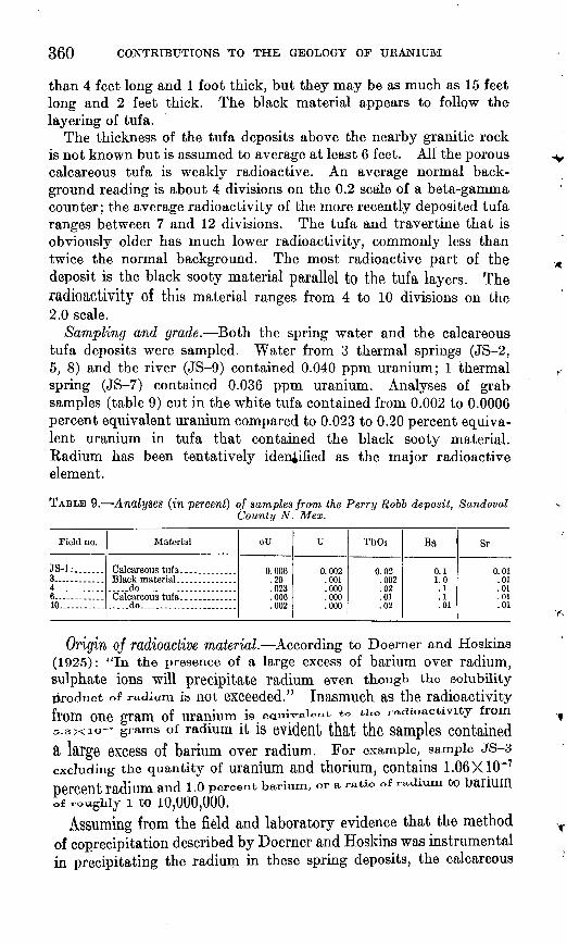
360 CONTRIBUTIONS TO THE GEOLOGY OF URANIUM
than 4 feet long and 1 foot thick, but they may be as much as 15 feet long and 2 feet thick. The black material appears to follow the layering of tufa.
The thickness of the tufa deposits above the nearby granitic rock is not known but is assumed to average at least 6 feet. All the porous calcareous tufa is weakly radioactive. An average normal back ground reading is about 4 divisions on the 0.2 scale of a beta-gamma counter; the average radioactivity of the more recently deposited tufa ranges between 7 and 12 divisions. The tufa and travertine that is obviously older has much lower radioactivity, commonly less than twice the normal background. The most radioactive part of the deposit is the black sooty material parallel to the tufa layers. The radioactivity of this material ranges from 4 to 10 divisions on the 2.0 scale.
Sampling and grade. Both the spring water and the calcareous tufa deposits were sampled. Water from 3 thermal springs (JS-2, 5, 8) and the river (JS-9) contained 0.040 ppm uranium; 1 thermal spring (JS-7) contained 0.036 ppm uranium. Analyses of grab samples (table 9) cut in the white tufa contained from 0.002 to 0.0006 percent equivalent uranium compared to 0.023 to 0.20 percent equiva lent uranium in tufa that contained the black sooty material. Radium has been tentatively identified as the major radioactive element.
TABLE 9. Analyses (in percent) of samples from the Perry Robb deposit, SandovalCounty N. Mex.
Field no.
JS-L. ......3............4............6............10
Material
Calcareous tufa... .........
.....do..... .............
..... do ......... ...... ...
eU
0.006.20
noQ
H09
u
n nn9001
.000
.000000
Th02
0.02.002
.01
.02
Ba
0.11.0
. 1
.1
.01
Sr
.01
.01
.01
.01
Origin oj radioactive material. According to Doerner and Hoskins (1925): "In the presence of a large excess of barium over radium, sulphate ions will precipitate radium even though the solubility product of radium is not exceeded." Inasmuch as the radioactivity from one gram of uranium is eau.iWU~* to *KO radioactivity from5.3X10 grams of radium it is evident that the samples contained a large excess of barium over radium. For example, sample JS-3 excluding the quantity of uranium and thorium, contains 1.06X10"7percent radium and 1.0 percent barium, or a ratio of radium to bailUm
of x-oughij i to 10,000,000.Assuming from the field and laboratory evidence that the method
of coprecipitation described by Doerner and Hoskins was instrumental in precipitating the radium in these spring deposits, the calcareous
RADIOACTIVE DEPOSITS IN NEW MEXICO 361
tufa, mainly calcite, and the radioactive material, radium, have been precipitated from solution in thermal spring waters that have cooled and partly evaporated at the surface. The abnormal temperature of the water may be caused by igneous activity, by heat developed along a fault plane, or by exothermic chemical reactions. Probably the path of the water passes near or through a body of uncooled igneous instrusive rock. The calcite in the tufa could be derived from lime-rich beds in the overlying Magdalena group and Abo sandstone, alteration of calcic feldspar and other minerals in the ignepus rocks, or calcium-rich primary magmatic solutions. The lime-rich beds in the overlying formations are believed to be the most probable source.
The radium coprecipitated with barium sulfate must have come from uranium somewhere along the path of the spring waters. It is not known whether the uranium, from which the radium was derived, is an epigenetic deposit in the form of a vein or dissemination or a syngenetic deposit of uranium minerals in the rocks traversed by the spring waters. Also, it is not known whether the uranium has been dissolved and washed away by the spring waters or whether the deposit is, for the most part, still in place.
CASEMAN WELL
Slight radioactivity was found by Bachman and Read (unpublished report, 1951) in travertine around Caseman well, 10.6 miles north of San Ysidro.
SAN YSIDRO COALFIELD
Radioactive coal has been found (Bachman, G. 0., and Read, C. B., unpublished report, 1951) in the San Ysidro coalfield in sec. 31, T. 15 N., R. 1 E., New Mexico principal meridian (fig. 49, deposit 15). This coal is in the Upper Cretaceous Dakota sandstone in beds about 1 foot thick which grade laterally into carbonaceous shales. The coal is estimated to contain 0.002 percent equivalent uranium.
LA VENTANA MESA
The information on La Ventana Mesa, as. well as that on the San Ysidro coalfield and the Spanish Queen group, has been taken from unpublished reports by Bachman and Read (1951) and by Vine, Bachman, Read, and Moore (1953).
La Ventana Mesa is about IK miles east of La Ventana, N. Mex. (fig. 49, deposit 11). Radioactive coal and shale are present in the upper part of the Cretaceous Mesaverde formation near the top of the mesa, and the La Ventana sandstone member of the Mesaverde formation that caps the mesa contains carnotite. Uranium is also present in carbonaceous lenses in the basal member of the Mesaverde
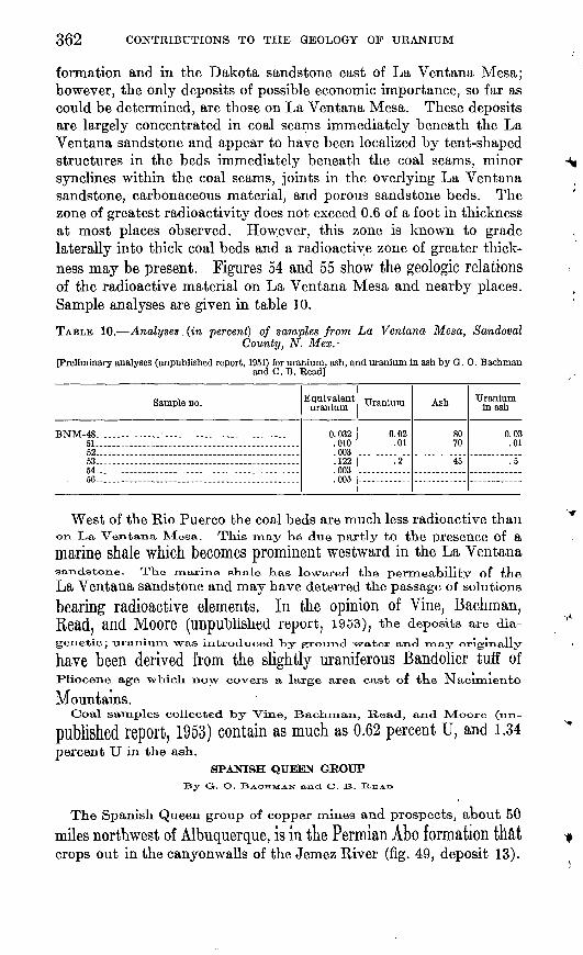
362 CONTRIBUTIONS TO THE GEOLOGY OF URANIUM
formation and in the Dakota sandstone east of La Ventana Mesa; however, the only deposits of possible economic importance, so far as could be determined, are those on La Ventana Mesa. These deposits are largely concentrated in coal seams immediately beneath the La Ventana sandstone and appear to have been localized by tent-shaped structures in the beds immediately beneath the coal seams, minor synclines within the coal seams, joints in the overlying La Ventana sandstone, carbonaceous material, and porous sandstone beds. The zone of greatest radioactivity does not exceed 0.6 of a foot in thickness at most places observed. However, this zone is known to grade laterally into thick coal beds and a radioactive zone of greater thick ness may be present. Figures 54 and 55 show the geologic relations of the radioactive material on La Ventana Mesa and nearby places. Sample analyses are given in table 10.
TABLE 10. Analyses. (in percent) of samples from La Ventana Mesa, SandovalCounty, N. Mex.-
[Preliminary analyses (unpublished report, 1951) for uranium, ash, and uranium in ash by O. 0. Bachmanand 0. B. Read]
Sample DO.
BNM-48... ...i ............................Bl... ............................................62..... --_-- _. .._ _.. _..-.53 . ' . . . . 54 56
Equivalent uranium
0.032.010.003.122.003.005
Uranium
0.02.01
.2
Ash
8070
45
Uranium in ash
0.03.01
.5
West of the Rio Puerco the coal beds are much less radioactive than on La Ventana Mesa. This may be due partly to the presence of amarine shale which becomes prominent westward in the La Ventanasandstone. TKe marine shale has lowered the permeability of tneLa Ventana sandstone and may have deterred the passage of solutionsbearing radioactive elements. In the opinion of Vine, Bachman,Read, and MOOre (Unpublished report, 1953), the deposits are dia-genetic; uranium, was introduced, by ground water and rnay originally
have been derived from the slightly uraniferous Bandolier tuff ofPliocene age which now covers a large area east of the Nacumento
Mountains.Coal samples collected by Vine, Bachman, Read, and M!oore (un-
published report, 1953) contain as much as 0.62 percent U, and 1.34percent U in the ash.
SPANISH QUEEN GROUPBy G. O. BACHMAN and C. B. HEAX>
The Spanish Queen group of copper mines and prospects, about 50
miles northwest of Albuquerque, is in the Permian Abo formation that crops out in the canyonwalls of the Jemez River (fig. 49, deposit 13).
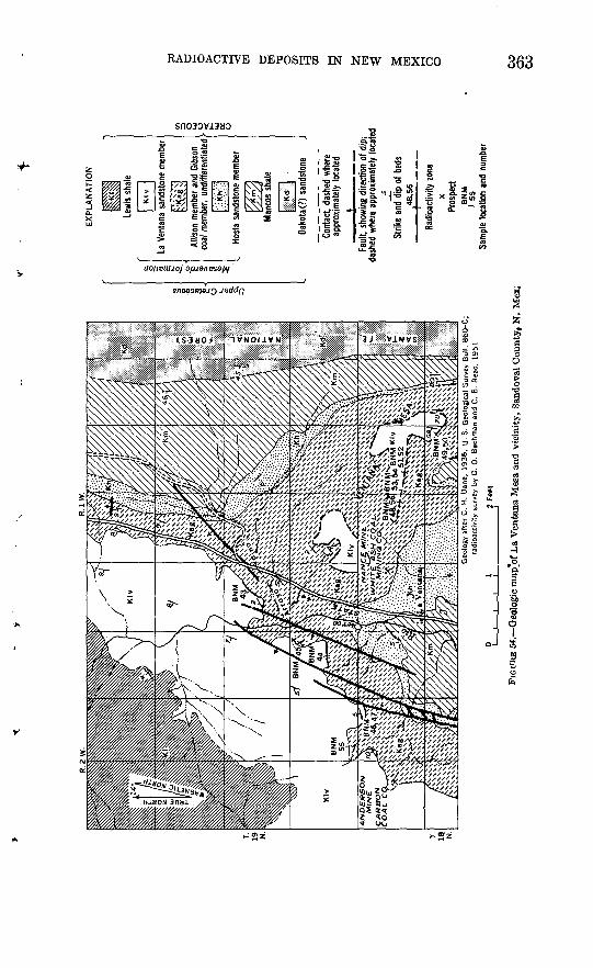
EX
PL
AN
AT
ION
Geo
logy
after
C.
H.
Dan
e,
19
36
. U
. S
. G
eolo
gica
l S
urve
y B
ull.
860-C
; ra
dio
act
ivity
sur
vey
by G
. 0.
Bac
hman
and
C.
B.
Rea
d,
1951
Klv
La V
enta
na s
ands
tone
mem
ber
Allis
on m
embe
r an
d Gi
bson
co
al m
embe
r, (^
diffe
rent
iate
d
Host
a sa
ndst
one
mem
ber
Dako
ta (?
) sa
ndst
one
Cont
act,
dash
ed w
here
ap
prox
imat
ely
loca
ted
.»_
__
__
__
Faul
t, sh
owin
g di
rect
ion
of d
ip;
dash
ed w
here
app
roxim
atel
y lo
cate
d
Strik
e an
d di
p of
bed
s,4
8,5
6
Radi
oact
ivity
zon
ex
Pros
pect
BN
MI
55Sa
mpl
e lo
catio
n an
d nu
mbe
r
FIG
URE
54.
Geo
logi
c map
'of L
a V
enta
na M
esa
and
vici
nity
, Sa
ndov
al C
ount
yf N
. M
ex;
O > i
O > O O
H
*d
O
CG
I <
H
CO O
O CO
O
5 C
O
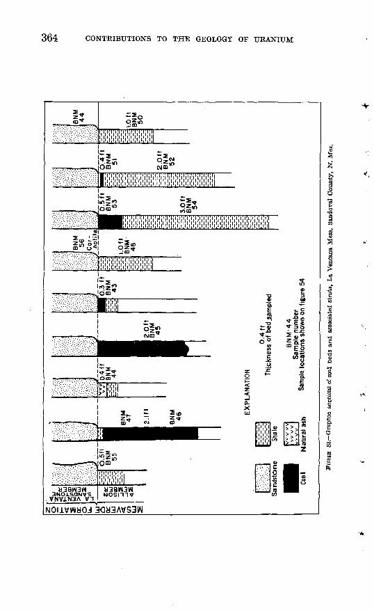
364 CONTRIBUTIONS TO THE GEOLOGY OF URANIUM
om
!*5S,' Si?-.. . .-!>. - m
I'l'l'l'l'l'l'l'l'l I I I Ill 1.1,1, ll 1.1 ,t ,1 ll 1111 ill I
|«z5? Jotn^
w o
4
30H3AVS3W
RADIOACTIVE DEPOSITS IN NEW MEXICO 365
Intermittent operations over a considerable period of time have re sulted in the development of two small mines and several prospects, none of which was active in 1951. One of these small mines is the East Spanish Queen mine (fig. 56).
EXPLANATION
U
U, upthrown side; D, downthrown side
^M^^M Inferred limits of ore body
Surface working and dump
Underground working
H Shaft
Caved ground
njz=tMine track
BNM 34Sample location and number
Mopped by G. 0. Bochmon ond C. B. Reod, August I9SI
FIGURE 56. Sketch map of the East Spanish Queen mine, Jemez. Canyon, Sandoval County, N. Mox.
The series of prospects on the east side of the Jemez River was examined and found to be variably radioactive through a vertical zone up to 6 feet thick. Radioactivity seems to be stronger in and near carbonaceous material which is also the place of concentration of the copper sulfides chalcocite and bornite. Estimated average equiva lent uranium in the copper ore body is 0.01 percent, but selected
366 CONTRIBUTIONS TO THE GEOLOGY OF URANIUM
samples contain as much as 0.1 percent equivalent uranium. No identifiable uranium minerals were observed. The copper content of the deposit is believed to average about 3 percent and the inferred magnitude of the ore body is 20,000 tons.
One small mine has been developed in the west wall of Jemez canyon. Sparse copper ore is present in 6 feet of sandstone and siltstone; the estimated grade of the ore is not in excess of 1 percent. Radioactivity is apparent throughout the workings, partly due to radon gas con tamination in the stagnant air. Equivalent uranium is estimated at 0.01 percent, but selected samples may contain 0.1 percent. The inferred size of the sandstone ore body is about 10,000 tons.
LITERATURE
The first report on radioactive occurrences in the county was by Granger (unpublished report, 1951) who made a thorough investiga tion of the Perry Robb hot springs near Jemez Springs. This report was soon followed by a reconnaissance report by Bachman and Read (unpublished report, 1951) that describes the radioactivity at Caseman well, Jemez Springs, San Ysidro coalfield, La Ventana Mesa, and the Spanish Queen copper deposits. The Spanish Queen prospects were later visited and briefly summarized by Gott and Erickson (unpub lished report, 1951). Read (unpublished report, 1952) and Vine, Bachman, Read, and Moore (unpublished report, 1953) re-examined the deposits in the La Ventana Mesa area.
SAN JUAN COUNTY
The uranium deposits of San Juan County in northwestern New Mexico are confined to carnotite disseminated in the Morrison forma tion. The stratigraphy and lithology of the carnotite ore strata have been discussed in a paper by L. C. Craig and V. L. Freeman (unpub lished report, 1951). The uranium has been found only in the basalor Salt W&sh sandstone member of the Morrison formation, The Salt Wash sandstone is a continental stream deposit composed domi-nantly of fine- to medium-grained sandstones with some interbedded sandy siltstones. Ore does not occur where there is little sandstoneor where the sandstone units are thin, platy, and lenticular. The descriptions of the carnotite deposits of the Oak Springs and Navajo Reservation districts follow. No reports on the deposits at Beautiful Mountain or Toadlena (fig. 49, deposits 2, 4) were available before1952,
Some gas wells in the Rattlesnake field in the west-central part of the county -were tested (McNeal, R. P., 1950a unpublished report),
but the uranium content was negligible. Three helium-bearing gas wells in the northwestern part of the county were checked for radio activity, and water samples were analyzed in the Denver laboratories
RADIOACTIVE DEPOSITS IN NEW MEXICO 367
of the Survey. No unusual radioactivity could be detected with a Geiger counter, and the highest uranium content in any of the water samples was only 0.04 parts per million of uranium.
OAK SPRINGS DISTRICT, CANYON NO. 2 CLAIM
Canyon No. 2 claim in the Oak Springs district (fig. 49, deposit 1) is located about 10 miles north of Redrock, Ariz., and about 1 mile east of the Canyon claim which is on the New Mexico-Arizona border. The claim was held and had been operated by Cato Sells before 1952. A road leads to a rim 20 feet above the mine workings.
Five small exposures have been worked, and a few tons of carnotite ore have been shipped.
The ore is in the Salt Wash sandstone member of the Morrison formation. The position of the contact between the Salt Wash sandstone and the Bluff sandstone is unknown. The ore is concen trated in a body 20 feet west of a basaltic dike and in bodies adjacent to the dike. The dike, which strikes N. 20 W. and dips vertically, is about 3 feet thick. Another dike of similar attitude, but only 1 foot thick, cuts the claim about 300 feet farther west. No alteration of the sandstone near the dike is evident; nor is there any noticeable displacement of the bed, which has a regional dip of 3° to the east. The ore extends 200 feet west of the dike; it extends only 12 feet to the east but reappears again in a small area 425 feet away from the dike. The sandstone enclosing the ore is light gray, fine grained, and shows crossbedding. Above and below the sandstone are blue-green clays containing a few fossil branches and other carbonaceous ma terial. Above the upper clay seam is a massive buff sandstone. A second mineralized seam, not over 3 inches thick, is 15 feet above the main zone.
The environment and existing exposures point favorably to the possibility of finding more ore on the claim.
NAVAJO RESERVATION (DISTRICT 12), JOHNSON CLAIM
The Johnson claim is approximately 3 miles east of the Arizona State line (fig. 49, deposit 3). A measurement from an aerial-photo graph mosaic showed the location to be about latitude 36°24' N., longitude 109°0' W. A wagon road runs to the claim, but the last \% miles are impassable by automobile.
In 1951 the claim was held jointly by Innes Johnson, Sr., and Innes Johnson, Jr., of Sanastee, N. Mex.
The area examined was on the southern and southwestern cliffs of a large mesa. The dip of about 15° toward the northeast causes the high cliffs to the south and west; to the east and northeast the mesa grades into the flats. The carnotite deposits are in the Salt Wash sandstone member of the Morrison formation about 100 feet above
368 CONTRIBUTIONS TO THE GEOLOGY OF URANIUM
the base. Three areas of rather strong uranium mineralization are spaced at about 1 mile intervals around the mesa. Between these areas most of the surface is covered with unconsolidated sand. Vana dium minerals are abundant on these sand slopes, but uranium min erals are sparse.
Although adequate information as to the extent of mineralization between the widely separated exposures will not be available without further exploratory work, it is felt that the few mineralized areas now visible do not warrant further field work on this particular claim.
LITERATURE
The first radioactivity survey in the county was made by McNeal (unpublished report, 1950), who investigated several gas wells in and around the Rattlesnake field in 1950 but found no unusual radio activity. In the spring of the following year Ellsworth (written com munication, 1951) and Hatfield (written communication, 1951) visited two carnotite prospects on the Navajo Reservation in western San Juan County. At about the same time an unpublished report (1951) on the distribution, stratigraphy, and lithology of the ore strata was prepared by Craig and Freeman. Stokes (1951) reported on the carnotite deposits of the Carrizo Mountains area in New Mexico and Arizona. The deposits at Beautiful Mountain and Toadlena are shown on Craig and Freeman's map but are not discussed indi vidually in their report.
SIERRA COUNTY
The only locality in Sierra County on which uraniferous material had been developed before 1952 is the Terry uranop/hane prospect,about 2 miles northeast of the town of Monticello. A piece of radio active ilmenite "float" was picked up in the Hillsboro district andthere are rumors of pitchblende "ledges" in the Black Range; however,a Geiger counter surrey of the area failed to locate any radioactive deposits.
FROSFECT, MONTTCEULO
By H. C. GRANGER
Uranophane is associated with fluorite in jasperoid breccia on the Terry prospect, 2 miles northeast of Monticello (fig. 49, deposit 19).
Tke Terry prospect, consisting of the Pitchblende Strikes NoS. 1, 2, 3,
and 4 claims, is just south of the San Mateo Mountains in sec. 26,X. 1O S., It. 6W"., New ^Mexico principal meridian. In 1951 tlie claims
were owned jointly by Ray Terry, Earl Terry, W. H. Terry, and W. H. Terry, Jr., of Hot Springs, N. Mex. The only development work on the claim consisted of 2 prospect pits in the uranophane-fluorite deposit and 2 small pits dug in the Quaternary gravels (fig. 57).
RADIOACTIVE DEPOSITS IN NEW MEXICO 369
The prospects may be reached by driving northerly from Monticello for 1.5 miles on the Red Rocks ranger station road and then going southeasterly for 0.7 mile on a poor ranch road. From this point an obscure track leads northeasterly for 0.5 mile to the prospect pits.
The deposit was examined on April 27, 1950, by H. C. Granger and Herman L. Bauer of the Geological Survey, accompanied by Ray Terry, of Hot Springs, N. Mex. A pace and compass map of the deposit was made on a scale of 1 inch equals 10 feet, and 7 samples were collected.
General geology. A bed of gray and red jasperoid which strikes about N. 50° W. and dips 40° NE. is the oldest rock on the Terry uranophane prospect. Its thickness is unknown. The jasperoid is tentatively identified as part of the Kelly limestone of Mississippian
PS-2, 0.006Somple locotion, number, ond
percent uranium
FIGURE 57. Geologic sketch map and section, Terry prospect, Sierra County, N. Mex.
370 CONTRIBUTIONS TO THE GEOLOGY OF URANIUM
age because of its lithologic similarity to rock described by Loughlin and Koschmann (1943, p. 53) in the nearby Magdalena district.
Beds of partly silicified limestone and sandstone, probably belonging to the Magdalena group of Pennsylvanian age, overlie the jasperoid. These beds strike N. 10° to 20° W. and dip 40° to 45° NE. A sill of feldspar porphyry at least 600 feet long and 200 feet wide cuts the jasperoid about 300 feet north of the uranophane deposits. The feld spar porphyry is light gray and contains feldspar phenocrysts about 3 mm in diameter in a felsitic groundmass. Quaternary gravels, com posed predominantly of cobbles and pebbles of igneous rocks, are in fault(?) contact with jasperoid in the southwest part of the map area (fig. 57).
The uraniferous deposits at the Terry prospect are in a fault breccia that strikes N. 68° W. across the jasperoid. The dip is not known but is assumed to be nearly vertical. The contacts of the breccia are indistinct. The breccia, composed of jasperoid fragments and a few fragments of igneous rocks (porphyry) and limestone, grades into frac tured jasperoid. The matrix of the breccia consists of silica and fluorite. Vugs in the fluorite are filled with white clay, and fractures in the fluorite and jasperoid contain uranophane and iron oxide. The sequence of mineral deposition is (1) quartz and chalcedony, (2) colorless crystals of fluorite in quartz, (3) green fluorite, (4) white clay, (5) hydrous iron oxide, and (6) uranophane and fluorescent hyalite. Silica occurs in the matrix as small quartz crystals, chal cedony, and jasper. The colorless and purple fluorite is commonly intergrown with quartz that was deposited contemporaneously with the fluorite. Vugs in the breccia are coated with fluorite crystals as large as 10 mm in diameter. Quartz veins cut the fluorite, andfluorescent hyalite coats fractures in jasperoid. Green fluorite is rare in the deposit and in places appears to be later than the purple variety.A white pulverulent hydrothermal clay mineral wholly or partly miscracks in the fluorite or fractures in the breccia.
Hydrous iron oxides on fractures in the breccia suggest that pyriteprobably is associated. witn the fluorite in tne unaltered parts 01 the
deposit. Uranophane has been deposited on fractures in fluorite; smallflat radiating groups of aeieular crystals less tnan 8 mm. in diameter
commonly coat fluorite or jasperoid. Uranophane is reported to bemore abundant in the lower 4 feet of prospect pit 1 matt lu pFeSent
exposures. Vugs in this part of the pit are lined with radiatingcrystals Of uranophane as long as one-naif inch.
Radioactivity. Four channel samples and a grab sample irOul thedump were taken at prospect pit 1, and a chip sample 4 feet long wascut at prospect pit 2 (table 11). A grab sample of the feldspar
RADIOACTIVE DEPOSITS IN NEW MEXICO 371
TABLE 11. Analyses of samples from the Terry prospect, Monticello, Sierra County,N. Mex.
[Radioactivity of samples P S-1 to P S-5 is given in the number of divisions on the 2.0 scale of a Qeigor counter"' radioactivity of samples PS-6 and PS-7 is given in divisions on the 0.2 scale]
Sample no.
PS-123...........4...........5.. .........6.... .......7.. .........
Description Radioac tivity
3333648
eU (percent)
0.006.008.012.037.028.002.005
U (percent)
0.005.006.010.034.027.001.004
porphyry was taken so that its uranium content might be compared with that of the breccia.
The uranium content of samples taken in this deposit ranged from 0.004 to 0.034 percent (fig. 57) in contrast to one dump sample taken by J. H. Soule (written communication, 1949), of the U. S. Bureau of Mines, which assayed 0.45 percent uranium oxide.
A sample of the feldspar porphyry intrusive rock contained 0.001 percent uranium. The dump sample taken by the U. S. Bureau of Mines probably represents material from the bottom of prospect pit 1, but this part of the deposit is now concealed. The presence of material of this grade, however, suggests that further exploration of the deposit, laterally or in depth, may result in finding similar grade ore. Other fluorite-bearing breccia zones in the jasperoid, if present, also should be prospected. In the southern part of the Magdalena district Loughlin and Koschmann (1943, p. 14-16, 53-54) described extensive areas of silicified Kelly limestone that might be worth prospecting for deposits similar to those on the Terry prospect.
RADIOACTIVE ILMENITE ON THE VIRGINIA CLAIM, HTLLSBORO DISTRICT
The following data have been abstracted from an unpublished report (1950b) by H. L. Bauer, Jr.
A specimen of radioactive ilmenite from the Virginia claim, Hills- boro district, Sierra County (fig. 49, deposit 20) was submitted to the Survey by the owner, Mr. B. 0. Bishop, of Silver City, N. Mex.
According to Mr. Bishop, development on the Virginia claim consists of a 52-foot vertical shaft, a 70- to 80-foot inclined shaft, and stopes. The openings are driven on the contact of an igneous rock and limestone. Vanadinite, wulfenite, galena, sphalerite, and cerus- site are reported to occur at the claim.. The ilmenite specimen was a piece of float found 1,500 feet north of the vertical shaft and just below a limestone-monzonite contact. Dimensions of the specimen were approximately 2 inches by 1 inch by half an inch. Calcite and epidote were noted on one corner of the specimen. The ilmenite
372 CONTRIBUTIONS TO THE GEOLOGY OF URANIUM
specimen contained 1.4 percent equivalent uranium. Results of chemical analyses for uranium were not available when this report was written. Employees of the Bureau of Mines in Silver City examined the Virginia claim with a Geiger counter and found no radioactivity higher than background.
REPORTED OCCURRENCE OF PITCHBUBNDE, BLACK RANGE
This information was taken from an unpublished report (1950c) by H. C. Granger and H. L. Bauer, Jr.
On March 8, 1950, Mr. J. G. McPherson, Silver City, N. Mex., reported a possible occurrence of pitchblende in the Black Range, N. Mex., in or near sees. 2, 11, or 14, T. 14 S., R. 10 W., New Mexico principal meridian. This area was examined by Granger and Bauer in April 1950, but their investigation did not reveal any areas of abnormal radioactivity or evidence of uranium minerals.
SOCOBBO COUNTY, SAN ACACIA DISTBICT
A deposit near San Acacia (fig. 49, deposit 18) in shear zones in an andesitic flow contains small quantities of dolomite (?) and carnotite associated with secondary copper minerals, calcite, and quartz. One sample selected from dump material contained 0.026 percent uranium.
TOBBANCE COUNTY, SCHOLLE DISTBICT
G. B. Gott and R. L. Erickson (unpublished report, 1951) mention the occurrence of calcite, malachite, and azurite with carbonized wood, lignite, and pellets of hydrocarbon in a sandstone belonging to the Abo formation of Permian age from the Scholle district, T. 2 N., R. 5 E. (fig. 49, deposit 17). In addition, an article in the Grand Junction Daily Sentinel dated June 23, 1949, reports a uranium discovery made on June 4 of that year by William Mclllhaney, of Albuquerque, 3 miles north of Scholle. The article reports a largearea of low-grade radioactive sandstone and siltstone cut by a smallseam containing carnotite. A 2-pound sample from an unknown locality in the Scholle district was submitted to the U. S. Atomic Energy Commission in Grand Junction in the spring of 1949. This sample was reported to contain 6.65 percent UsOs, 5.35 percent ¥265,and. 15.55 percent Cu.
VALENCIA AND McKINLEY COUNTIESGRANTS DISTRICT
Tne folio-wing general information, on tne Grants district Las been
taken from an unpublished report (1950) by K, P, Fischer and J, D,Strobell and from a more recent report by Irring Rappaport (1952).
The town of Grants, from which the district takes its name, is 80miles west of Albuquerque and 60 miles east of Gallup on Koute 66
RADIOACTIVE, DEPOSITS IN NEW MEXICO 373
and the main line of the Santa Fe railroad. Uranium ore appears to be largely confined to sedimentary rocks of Jurassic age which are exposed in a belt extending northeastward from near Grants almost to Gallup. Another broad belt, about 25 miles east of Grants, trends northward. Uranium is concentrated hi two stratigraphic zones. The lower zone is in the Todilto limestone and overlying basal Summer ville formation; the upper zone is in the Westwater Canyon sandstone and Brushy Basin shale members of the upper Jurassic Morrison formation, and overlying Dakota sandstone of Cretaceous age. These two zones are separated by 500 to 800 feet of barren rock.
General geology. The rocks in the Grants district, including the uranium-bearing formations, dip about 10° NE. from the broad Zuni Mountains uplift whose crystalline core is exposed about 25 miles to the southwest. The sedimentary rocks flanking the uplift range in age from Permian to Cretaceous. To the east they are buried by the Upper Cretaceous, Tertiary, and Quaternary volcanic rocks of the Mount Taylor field, but reappear east of these volcanic rocks. North ward the sedimentary rocks extend into the San Juan Basin.
A broad bench as wide as 2,000 feet in places has been developed on the Todilto limestone. Part of the bench is covered by a thin veneer of soil and by the basal beds of the overlying Summerville formation.
The Summerville formation consists of red-brown and white banded silty sandstone from 150 to 200 feet thick. The Summerville is overlain by the 150-foot thick Bluff sandstone, which is a massive white sandstone with local red and brown staining. The Bluff sand stone forms a cliff, but it is less extensive or prominent than the cliff formed by the Entrada sandstone that underlies the Todilto.
The Entrada, Todilto, Summerville, and Bluff formations together form the San Rafael group in this area.
The San Rafael group is overlain by 600 or 700 feet of Morrison rocks, predominantly sandstone, consisting of the Recapture shale, Westwater Canyon sandstone and Brushy Basin shale members; the Salt Wash sandstone member was not recognized in this region. The Morrison formation forms a steep slope interrupted by vertical cliffs, that rises to the Cretaceous Dakota sandstone escarpment.
The Todilto limestone is a thin-bedded dense gray crystalline limestone that weathers to tan, light gray, or white. Its thickness varies regionally from 5 to several tens of feet; where visible on the Rim Rock claim, the Todilto is estimated to be 12 to 15 feet thick. Eastward in New Mexico the formation is much thicker, contains gypsum, and the limestone is very fetid and bituminous. A fish fauna from the eastern (gypsiferous) facies of the Todilto limestone and the correlative Pony Express limestone member of Colorado is
374 CONTRIBUTIONS TO THE GEOLOGY OF URANIUM
said to be possibly marine, but no evidence of marine origin of this western facies of the Todilto limestone is now known.
The uranium deposits in Todilto limestone show a general tendency to concentrate along minor folds; the deposits also appear to have been lithologically controlled and are more abundant in the pure limestone than in the impure silty or gypsiferous facies.
Carnotite and tyuyamunite, the chief minerals, are found in thin isolated patches and discontinuous coatings on the joint and bedding surfaces. In some places they form a barely visible paint or stain, no more than a faint yellow coloration. In others, they are thick enough to form a brilliant yellow film.
In addition to carnotite and tyuyamunite, uranophane, sklodowskite (uranium silicates), rutherfordine (uranium carbonate), and pitch blende have been reported from the Todilto limestone.
Carnotite and abundant reddish-brown to black oxides of iron and manganese(?) cover the limestone and coat joint and bedding sur faces. The presence of the hydrous calcium vanadates hewettite or metahewettite is suspected.
Minor amounts of carnotite appear to be sparsely scattered through the limestone in a very patchy distribution; local concentrations are separated laterally by barren areas.
The Morrison formation consists of mudstone interbedded with sandstone and conglomerate. The Dakota formation consists largely of sandstone and subordinate mudstone interbedded with thin lenses of carbonaceous material. Uranium in the Morrison and Dakota formations is distributed throughout a stratigraphic range of 300 feet.
The most important uranium-bearing mineral in the Morrison and Dakota deposits is carnotite which "occurs as canary-yellow material interstitial between sand grains, as coating on mudstone galls, and asrich laminae which follow bedding planes for short distances and thentransect these original planes at small angles" (Rappaport,1952).
Some schroeckingerite has tentatively been identified as impreg nating sandstone and coating joints and bedding planes.
Description of deposits. The following are descriptions of a few of the deposits in the Grants area. They are modified from, unpub lished reports by M. J. Sheridan (1950) and A. Rosenzweig (1950) and from a published report by Rappaport (1952).
GLOVER CLAIMS
The Glover claims, in sec. 20, T. 14 N., R. 11 W., New Mexicoprincipal rn.erid.lan, were o\vmecL by Fred Glover, of !Prtiiit, N. A^Tex:.,
in 1950, M, J, Sheridan used a Geiger counter to examine the claims on November 21,1950. The Glover No. 2 claim covers minor occur-
RADIOACTIVE DEPOSITS IN NEW MEXICO 375
rences 2 to 3 feet below the top of the Todilto. Carnotite with man ganese oxide and abundant calcite reaches a maximum thickness of 1 foot and is traceable for 15 feet along the outcrop. Three other claims with reportedly less significant showings were not examined.
T. NOS. 1 TO 4 CLAIMS
The T. Nos. 1 to 4 claims in sec. 28, T. 14 N., R. 11 W., New Mex ico principal meridian, belonged at the time of examination to Henry Andrews, of Blue Water, N. Mex. The claims were recorded in Sep tember 1950 and examined on November 21, 1950. Four claims cover widespread occurrences along the east run and at the head of a north- draining canyon. Only the most southerly, Claim No. 1, was examined, but ore minerals can be traced almost continuously for at least 400 feet around the run at the head of the canyon. Radioactivity, which is generally weak, seems to be confined to a 0.5- to 1.0-foot layer at, or near, the top of the Todilto. Minor radioactivity in float was noted 100 to 200 feet back from the run. A sample chipped from several points on the outcrop represents only the high-grade mate rial and contained 0.21 percent equivalent uranium.
ANDREWS PROPERTY
An unnamed carnotite deposit to which W. C. Andrews, of Pruitt, N. Mex. had mineral rights in 1950 lies in sec. 19, T. 14 N., R. 11 W. In a U-shaped indentation in the rim. of the Todilto two outcrops show a zone of easily traceable ore minerals 1 to 3 feet below the top of the formation. One exposure on the north flank of the U is con tinuous for about 100 feet and shows carnotite(?) in fractures on bedding planes throughout a 1- to 3-foot zone. About 100 feet east of this exposure another 75-foot zone is continuously but weakly mineralized through thicknesses ranging from a few inches to 2 feet. Radioactivity traversing of part of the area back from the rim dis closed spotty concentrations of ore minerals. A random chip sample contained 0.20 percent equivalent uranium.
BOTTOMS CLAIMS
Two claims, in sec. 18, T. 14 N., R. 11 W., New Mexico principal meridian, were owned by Lloyd Bottoms, of Pruitt, N. Mex., when they were traversed with a Geiger counter on November 21,1950. The claims cover weakly mineralized outcrops in a south-facing rim of Todilto limestone. The best ore is in a 0.2- to 0.5-foot zone traceable radiometrically for about 25 feet. A sample taken where the zone is 0.4-foot thick contains 0.07 percent equivalent uranium. About 400 feet to the west and 100 feet to the east small mineralized areas were detected by the counter.
376 CONTRIBUTIONS TO THE GEOLOGY OF URANIUM
LAWRENCE ELEINS CIAIM
This claim is in sec. 24, T. 14 N., R. 12 W., and belonged to Lawrence Elkins, of Pruitt, N. Mex. in 1950. It is on an isolated mesa that is inaccessible by road. The mesa is entirely capped by Todilto lime stone and the rim had, as of 1950, been only lightly prospected. Radio active float, which is probably near its source, is distributed for about 40 feet along a shallow gully traversing the mesa. Calcite and man ganese oxides are common. A sample chipped from various boulders of radioactive float contained 0.39 percent equivalent uranium.
HARD WORK, RED POINT, AND OTHER CLAIMS
A group of claims that belonged in 1950 to Jim Hutton and Glen Williams,'{off Grants, N. Mex., are in the N}£ sec. 16, T. 13 N., R. 10 W., New Mexico principal meridian. These claims were located in October 1950 and were examined in November 1950 with a Geiger counter. Reportedly, there are 15 claims along the rim of Todilto in this open area. The only mineralized area noted was in the discovery cut at the top of the run on one of the claims (probably the "Hard Work"). The cut, approximately 12 feet by 5 feet and 3 feet deep, exposed ore minerals in the upper 2 feet of the Todilto limestone, which in this locality is 7 to 8 feet thick. About 30 feet back from the rim ore minerals were noted in one boulder that was probably in place. A sample of the highest grade material in the discovery cut contained 1.18 percent equivalent uranium. The outcrop was checked at various places for several hundred feet in both directions from the discovery cut, but no other mineralized areas were seen.
RED BLUFF CLAIM GROUP
The Red Bluff No. 1 claim belonged in 1950 to O. A. Jones et al.,Grants, N. Mex., and is in sec. 36, T. 13 N., R. 10 W., New Mexicoprincipal meridian. It was examined with a Geiger counter in No vember 1950. Two mineralized areas are exposed in the western part of a northward-trending finger of a Todilto-capped bench. The
southern area exhibits, for about 75 feet along the outcrop, a weaklymineralized zone in thin-bedded limestone near the base of the forma tion. The maximum thickness of mineralized rock noted was about3 feet; a sample contained 0.14 percent equivalent uranium. About
150 feet to tke north the outcrop is continuously mineralized near the base of the formation for 150 feetj the deposit is less than a foot thick
except in one zone where fractures and bedding planes throughout the8 to 9 feet of Todilto contain carnotite. A sample of the most radio active rock contained 0.37 percent equivalent uranium.
The Red Bluff Nos. 2 to 7 claims are in sec. 4, T. 12 N., R. 9 W. and belonged to the owners of the Red Bluff No. 1 when they were exam-
RADIOACTIVE. DEPOSITS IN NEW MEXICO 377
ined in November 1950 with a Geiger counter. Five claims that cover about 3,000 feet of the run of Todilto include several widely distributed radioactive exposures in the upper part of the Todilto limestone. A location cut on the Red Bluff No. 2 claim, at one of the more promising places, exposes rock with weak radioactivity in the joints and seams of the upper 2 to 3 feet of limestone. Radioactivity was not traceable along the outcrop away from the cut. A sample, selected from the highest grade material exposed in the cut, had an equivalent uranium content of 0.08 percent. A further examination of the outcrop showed very local areas, 5 to 10 feet long, of weakly mineralized rock.
The Red Bluff Nos. 7 and 8 claims are in sec. 4, T. 12 N., R. 9 W., New Mexico principal meridian. They belonged in 1950 to the owners of the other Red Bluff claims. In one test pit of the Red Bluff No. 7 claim carnotite coats bedding-plane and joint surfaces in the Todilto limestone. One sample from this pit contained 0.11 percent equi valent uranium. The Red Bluff No. 8 claim is mineralized for 50 feet along the run. A sample from the richest portion of the rim, where excavation has begun, contained 0.63 percent UaOg, and 0.53 percent V205 .
GRAY EAGLE, BLACKHAWK, AND BONNEY CLAIMS
0. A. Jones and J. C. Dorsett, of Grants, N. Mex., owned these claims, in sec. 4, T. 12 N., R. 9 W., New Mexico principal meridian when the claims were examined with a Geiger counter on November 19, 1950. These claims extend about 3,000 feet along a Todilto limestone outcrop that is weakly and discontinuously mineralized near the top. The extent of individual radioactive exposures along the outcrop is commonly only a few feet, although one exposure was about 75 feet long. Locally, parts of the Todilto are strongly radioactive, and at these places shallow test pits were being sunk to fulfill claim location requirements.
A sample taken from a 3-foot thickness at an outcrop where ab normal radioactivity is traceable for 15 feet, showed an equivalent uranium content of 0.20 percent. Another sample from a 4-ton discovery-cut stockpile nearby had an equivalent uranium content of 0.17 percent. Only the most radioactive material was sampled. A sample was taken from an ore bed 10 to 12-inches thick which could be traced a few feet only; the ore was exposed in the bottom of a gully 100 feet back from the rim of the outcrop. It had an equivalent uranium content of 0.71 percent, which was the highest of any samples taken. A sample from the Blackhawk discovery cut, on the rim of Todilto where carnotite was erratically distributed through a bed 2 to 3 feet thick and traceable only a few feet beyond the cut, had an equiva lent uranium content of 0.27 percent.
378 CONTRIBUTIONS TO THE GEOLOGY OF URANIUM
MARK ELKINS CLAIM
On an unnamed claim in the N% sec. 19, T. 12 N., R. 9 W., New Mexico principal meridian, carnotite is present at the top of the Todilto and can be traced 150 to 170 feet along the outcrop. The claim belonged in 1950 to Mark Elkins, a rancher of Grants, N. Mex. The ore ranges from a few inches to 2 feet, in apparent thickness. Dis continuous ore was noted 4 to 5 feet below the top zone also. Soil cover obscures the limestone back from the run and the extent of the ore zone in this direction could not be determined. No exploratory work of any sort had been undertaken before 1950 on this deposit. Samples chipped at several places along the outcrop, although repre sentative of only the more highly mineralized rock, give some indica tion of the probable grade. These chip samples contained an average of 0.25 percent equivalent uranium.
RAILROAD SECTIONS
Four railroad sections in the Grants district were examined and the results of these investigations (Anonymous, 1951) are summarized below.
Uranium minerals were seen on land belonging to the Santa Fe railroad, sec. 13, T. 13 N., R. 11 W., New Mexico principal meridian. The deposit was examined with a Geiger counter on November 20, 1950. Carnotite is present in a V-shaped indentation in the rim of Todilto limestone. The mineralized zone ranges in thickness from a few inches to 4 feet and is continuous for approximately 900 feet along the outcrop. The mineral-bearing stratum is from 1 to 4 feet below the top of the formation and exhibits fracture- and bedding-plane fillings typical of other deposits in this area. The intensity of radio activity is variable. A sample taken from a 2-foot zone at the best point on the outcrop shows an equivalent uranium content of 0.58 percent. Another sample chipped from an average-looking 4-foot face contained 0.10 percent equivalent uranium.
A railroad section claim, belonging to the Santa Fe, in the NX sec. 19, T. 13 N., R. 10 W., New Mexico principal meridian was examined with a Geiger counter on November 18, 1950. The Todilto outcrop is mineralized for about 1,500 feet at or near the top of the formation. The heaviest concentration "of radioactive material is exposed in a 2- foot zone that is comparatively well mineralized for about 35 feet along the outcrop. The extent of the mineralized ground behind the rim has not been determined, though rapid radiometric traverses indicategradual reduction to a. normal count at 5O feet. Ttie deposits TTOTG
estimated to be contained in a block 35 feet by 35 feet by 2 feet.A grab sample from a 10- to 15-ton stockpile had an equivalent
uranium content of 0.68 percent. Stripping exposed two other areas
RADIOACTIVE DEPOSITS IN NEW MEXICO 379
to the west with abnormal radioactivity. They measured 10 to 12 feet along the outcrop and were as much as 1 foot thick.
Another section, sec. 25, T. 13 N., R. 10 W., belongs to the Santa Fe railroad. The Todilto crops out in the northwest corner of the section several hundred feet north of the rim. Carnotite with hematite and limonite is present through 1 to 5 feet of limestone continuously for more than 100 feet along the outcrop. Traces of ore minerals were found in the underlying limestone. The restriction of mineralization to fractures and seams has made estimates of ore potential difficult. Samples taken from various points along the outcrop, indicative of the better material, had an equivalent uranium content of 0.26 percent.
Still another section belonging to the Santa Fe railroad, in sec. 19, T. 13 N., R 9 W., contains uranium deposits in the Westwater Canyon sandstone member of the Morrison formation. The Dakota sandstone and Morrison formation crop out along a prominent cliff in the north ern part of the section. Uranium is present in several stratigraphic zones in the Westwater Canyon member, both in the cliff and in isolated erosion remnants south of it. The ore deposits are similar in most respects to typical deposits in the Salt Wash sandstone farther north on the Colorado Plateaus. They are concentrated along chan nels and in sandstone rolls; carnotite is closely associated with car bonized wood fragments and limonite; clay and mudstone surrounding ore-bearing lenses are commonly altered from red to green. These deposits differ from those in the Salt Wash in having a low vanadium content. Several tons of ore averaging 0.67 percent U308 had been shipped from this property before 1953.
INDIAN ALLOTMENTS
A reconnaissance investigation was made of two radioactive occur rences on Indian allotments. The data on these deposits are sum marized below.
An Indian allotment held in 1950 by the Desedillo family of Pruitt, N. Mex., is in sec. 26, T. 13 N., R. 10 W., New Mexico principal merid ian. Here the Todilto limestone forms a south-facing cliff, and is mineralized for a distance of at least 70 feet, 30 feet of which contains variable amounts of carnotite in a 2-foot zone near the base of the formation. At one point where the ore was thickest, the entire 12 feet of limestone was mineralized for some 10 feet along the outcrop. Slight local folding may have helped to localize the ore. The remain ing 40 feet of mineralized outcrop to the east has carnotite distributed along the joints; but the carnotite is confined mostly to the same 2-foot zone mentioned above. Away from the run the soil cover obscures most of the limestone; but scattered outcrops 15 feet away from the rim contain ore showings and a trace can be noted at 45 feet. Back of the run along the banks of a stream the Todilto is exposed hi the NE% of
380 CONTRIBUTIONS TO THE GEOLOGY OF URANIUM
the same section for several hundred feet. Two small radioactive areas containing mineralized float were found. Traces of ore minerals were noted in the underlying sandstone. A chip sample representing the higher grade material in the NW% section contained 1.70 percent equivalent uranium.
An Indian allotment, in the SW% of sec. 18, T. 13 N., R. 10 W., New Mexico principal meridain, was examined with the'jaid ;of a Geiger counter. It was under tentative lease in 1950 to Jim Hutton and Glen Williams, of Pruitt, N. Mex. Here the Todilto limestone is exposed in the bottom of a minor gully an estimated 1,500 feet north of the rim outcrop. Between 1 and 2 feet of overlying soil and barren limestone have been stripped away and an area 15 by 40 feet showing carnotite-mineralized joints and bedding planes has been uncovered. The thickness of the ore zone, indicated in a small test pit, is about onefoot. Chip samples from the pit contained 0.08 percent equivalenturanium. A radioactivity check of surrounding soil-covered areas indicated a limited extent only for the stripped deposit but revealed other areas of abnormal radioactivity 200 feet west and 100 feet south.
JONES CLAIM
An unnamed claim, belong in 1951 to A. 0. Jones, of Grants, N. Mex., is in sec. 33, T. 12 N., R. 9 W., New Mexico principal meridian. It was examined with a Geiger counter on January 7, 1951. The deposit is at the intersection of two steep gullies at the base of a lava-capped mesa. About 12 feet of limestone are exposed. The upper 4 to 6feet are thick bedded; radioactivity ranges from strong to weak; the lower portion of the limestone is thin bedded and weakly to moderatelymineralized. A selected sample of thick-bedded limestone contained
0.98 percent U308 and 0.54 percent V205 ; a sample of the thin-bedded lower limestone contained only 0.21 percent equivalent uranium.
ZUNl MOUNTAINS AREA.
Gott and Erickson (unpublished report, 1951) mention radio-activity associated with, malachite, etzaarite, eliirysoeolla, ftuoi-ite, arid
calcite in joints and fractures in arkosic sandstones and conglomeratesof Permian age and altered pre-Cambrian granite from the ZuniMountains, T. 11 N., !R. 12 W. (fi&. -4O, deposit 16). Selected samples
Of tlie radiOaCtlYe material contained 0,009 percent uranium, 4.5
percent copper, and 0.02 percent V2O5 .
The first discussion of uranium In the Grants district was in an unpublished report (1950) by Fiscner and StroDell. This memoran dum covers, in a general way, the location, history, geology, andmineralogy of the entire district but gives little specific information
RADIOACTIVE, DEPOSITS IN NEW MEXICO 381
on the individual properties. Later in the same year most of the known properties were visited by Sheridan (unpublished report, 1950) and a few by Rosenzweig (unpublished report, 1950) who summarized their findings in a preliminary reconnaissance report for each property. A preliminary report on the uranium deposits of the Grants district was also prepared by M. L. Reyner and M. J. Sheridan (unpublished report, 1950) for the U. S. Atomic Energy Commission. The minerals found in the district were the subjects of careful laboratory analyses by Gruener and Gardiner (written communication, 1951) who presented their results in a progress report to the Atomic Energy Commission. A more detailed report on the Grants district was prepared by Irving Rappaport (1952) for the Atomic Energy Commission.
OTHER REPORTED OCCURRENCES
In addition to the deposits discussed in the preceding pages, seven reported radioactive occurrences from the State had not recently been investigated by geologists of the U. S. Geological Survey or the U. S. Atomic Energy Commission before 1952 and, therefore, are not described here. These are Elizabethtown, Peralta Canyon, Rociada, the Organ Mountains, Elk Mountain, the Little Hatchet Mountains, and the Glorieta deposits.
In 1902 an anonymous note in the Mining and Scientific Press mentioned the occurrence of uraninite in the President mine near Elizabethtown in Coif ax County (fig. 49, deposit 24). No details are given and no further references in the literature could be found. In 1910 the U. S. Geological Survey report by Lindgren, Graton, and Gordon on ore deposits of New Mexico (Prof. Paper 68) briefly mentions carnotite from Peralta Canyon, Cochiti district, in Sandoval County (fig. 49, deposit 25); but again no details are given. J. M. Hill mentions the presence of small noncommercial radioactive microlite-bearing pegmatites cutting pre-Cambrian granite near Rociada (fig. 49, deposit 26), in an unpublished report in 1945. S. B. Keith examined the Swanson-Lauer property in the Organ district (fig. 49, deposit 27) for uranium in 1944; but the results were negative. However, in 1950 a brief note appeared in the Engineering and Mining Journal saying that secondary uranium minerals had been reported from the Memphis King mine in the same district. The University of New Mexico Bulletin, Minerals of New Mexico, by Stuart Northrop (1942) lists the occurrence of uraninite, samarskite, and cyrtolite from pegmatites on Elk Mountain in San Miguel County (fig. 49, deposit 30). The same reference also lists a question able occurrence of autunite in the Eureka district, Little Hatchet Mountains, Grant County (fig. 49, deposit 28). O. B. Muench
382 CONTRIBUTIONS TO THE GEOLOGY OF URANIUM
reported in the American Chemical Society Journal in 1938 (Muench, 1938a) a detailed chemical and mineralogical study of a specimen of monazite from a pegmatite dike near Glorieta (fig. 49, deposit 29). In an abstract appearing in the Pan-American Geologist (Muench, 1938b) for the same year, the locality was stated to be somewhere near Taos.
CONCLUSIONS
Of the New Mexico uranium deposits that were known hi 1952, only those in the Grants district of Valencia and McKinley Counties had large proved reserves of uranium ore. Table 12 shows the signifi cant features of uranium deposits in New Mexico known before 1952. The carnotite deposits of the Carrizo Mountains area, San Juan County, are mostly small and widely scattered, but many of them contain pockets of good ore and it is probable that small quantities of uranium ore will continue to be produced from this area for some tune. If autunite and torbernite become commercially important sources of uranium, the deposits of these minerals in the White Signal district might constitute a valuable reserve. If continued exploration were to reveal the presence of substantial amounts of uranium oxides at Black Hawk or in depth at White Signal, these districts might become ore producers. The same may be said for the uranophane deposits at Monticello. Not enough exploration and development has been done at any of these places to indicate con clusively that there is or is not sufficient uraniferous material to constitute ore.
The pegmatites near Petaca do'not contain sufficient quantities ofuranium and thorium minerals to be minable for these elementsalone; however, it might be economically possible to recover them as byproducts from the production of beryl.
The low-grade uranium-bearing copper deposits in Mora, Rio Arriba, and Sandoval Counties might become of economic interest if the copper could be mined and the uranium could be recovered as a byproduct. With the possible exception of La Ventana Mesa the radio
active coal, black shale, and hot spring deposits in these COUntlGS now seem only of scientific interest, as is the radioactivity associated with the oilfields of Lea County.
The relatively wide distribution of known uranium occurrences inNew Mexico should encourage exploration,
TAB
LE 1
2.
Sign
ific
ant f
eatu
res
of r
adio
acti
ve d
epos
its
in N
ew M
exic
o
Dep
osit
Gra
nt C
ount
y:
Whi
te S
igna
l dis
tr
ict:
M
erry
Wid
ow
.
Apa
che
Tra
il-
Blu
e Ja
y __
Mon
arch
No.
2.
T
unne
l Si
te
No.
1.
Unc
le
Sam
si
lver
min
es
Hin
es N
o. 1
..
Bla
ck H
awk
dis
tr
ict.
Lea
Cou
nty:
H
obbs
fie
ld ..
....
Mon
umen
t fi
eld
.
Jal f
ield
__
__
_M
ora
Cou
nty:
C
oyot
e C
reek
....
Rio
Arr
iba
Cou
nty:
P
etac
a..
. .......
Coy
ote .
....
....
..
Cop
per
city
......
Loc
atio
n
Tow
n
ship
20 S
.
20 S
.
20 S
,
20 S
.
20 S
.
20 S
.
21 S
.
188.
18 S
.
19 S
. 24
S.
25 S
.
Sm
iles
lu
pite
26 N
.
22 N
.
21 N
.
Ran
ge
15 W
.
15 W
.
15 W
.
15 W
.
15 W
.
14 W
.
14 W
.
16 W
.
37 E
.
36 E
. 36
E.
37 E
.
sout
h of
i.
8E
.
3E
.
IE.
Sec
ti
on
22 2 26 19
26
32
34
Gua
da-
Dep
osit
no
. on
fig. 4
9 22 21
23 10 9 6 7
Typ
e of
dep
osit
Fra
ctur
e co
atin
g. .
Vei
n an
d di
ke ..
...
Fra
ctur
e co
atin
g..
.. d
o....
..
....
Wat
er in
oil
wel
ls..
..-.
-do
-...
.--
..- d
o..
...
....
. -.d
o ..
. . ..
Dis
sem
inat
ed . __
.. d
o..
.
..
Cou
ntry
roc
k
Gra
nite
and
dik
es.
Gra
nite
and
di
a
base
dik
e.
Gra
nite
and
dik
es.
Rhy
olit
edik
e .....
Gra
nite
, rh
yoli
te
di
kes.
Gra
nite
, gne
iss a
nd
dike
s.
Sed
imen
tary
rock
s (P
erm
ian)
. d
o. -- .
d
o - -
- do
Bla
ck s
hale
(Pe
r
mia
n).
Pre
-Cam
bri
an
Shal
e of
T
odil
to
limes
tone
(Jur
as
sic)
. S
ands
tone
of
Chi
n-
le f
m (
Tri
assi
c).
Min
eral
s
Aut
unit
e,
torb
erni
te,
pyri
te,
lim
onit
e,
quar
tz.
Tor
bern
ite
(Pb,
B
i, C
u)
sulf
ides
, lim
o
nite
, qu
artz
. T
orbe
rnit
e,
pyri
te,
spec
ular
ite,
clay
m
iner
als,
qua
rtz.
Lim
onit
e, c
lay
min
er
als,
qua
rtz.
Q
uart
z,
sulf
ide
min
er
als.
A
utun
ite,
fl
uori
te,
lim
onit
e, h
yali
te.
Pit
chbl
ende
, py
rite
, ga
lena
, sp
hale
rite
, su
lfid
es, c
arbo
nate
s,
quar
tz.
Ura
nini
te, m
etat
yuya
- m
unit
e,
chal
coci
te,
mal
achi
te.
Ura
nini
te, s
amar
skit
e,
mon
azite
, m
ica.
C
arbo
nace
ous
mat
e
rial
.
Car
boni
zed
woo
d, c
op
per
carb
onat
es,
and
solf
ides
.
Dev
elop
men
t
2 sh
afts
, 45
0 ft
of
wor
king
s.
200-
ft sh
aft,
265
ft
of w
orki
ngs.
Bul
ldoz
er tr
ench
es. -
250-
ft ad
it..
. ....
Sha
fts,
adi
ts,
stop
es.
Sha
fts
and
'seve
ral
thou
sand
ft
of
w
orki
ngs.
Oil
wel
ls,
3,00
0 to
4,
500
ft d
eep.
-..
.do
. . -
. ---
----
.... .do-..
Per
ce
nt
U
<2.
06
<.0
41
<.l
l
<.0
11 .67
(4)
Per
ce
nt
eU
........
<0.
018
(2)
<.0
27
(3)
<.0
05
<.0
06
Pro
duct
ion
]
Au^
U.'
Au
and
Bi
only
.
0).
0).
0).
Ag
only
.
(').
Ag'
only
.
Oil
only
.
Do.
D
o.
Do.
O GO OD H H O
O CO
0
0
CO
See
foot
note
s at
end
of
tabl
e.
384 CONTRIBUTIONS TO THE GEOLOGY 4QF URANIUM
aJo3
£
1
o>Pi
d
3P. 3*0
fl
Minerals
32
£§oO
aMa
73"o
o>I>%
"3 flo>g^O-*
rio
£( m
ts?
tfID,^
sfl
1,
V V
1 tQ U~
! ® o \' ^ V *] v
! o! o^ ! i^ w
| _« a1 "3 . t5
i 5Q ,23 o1 Co ^ C
i O P-i
- ** ^ J*73 Q> 73 G} 0 ft 0 P. fl 0 & 0 P. _°
O'C73 >> 73 t>» <U 0} *"* . & *" . ^
ii 103 W B C3 W 9 03 O a
O O O 0
^H O v«4 H Cl y\
£} §&. o'S 'So
<* 'S fl wS1 ^5 C45 73«2 * [g ^^ T: ^* fl QJ fl !-» ^ V*
O co >-} co
! ^ !i *3 '
"2 * -o03 60 rt
1 o S 1 C
J T;
ft £ ft
c T:
c
e( C,
a4-
C
£ c
cT:
c c
c7;
.ceous material
_^ do
0 T;
Ng g
V V
A Sa £O 03
Sooty radioactiv terial, calcite. Carbonaceous m
____do
«o
vCO C. ; . . -SV v ^"^
J
^2a
o
2a
If .fl 1
f qa q; ? . »-£ § l
H II ft « 11 ll0 P K
I li* i I^ S ^ S a ^ S *§ cjy, ^©^ 2 8*3. *o3 ^^CO.^^c3>-( ,® SS C*3 CCX3OTO5iJ3SJOPH S*T3 £
' aa
w-»
E-<o wwS w <! s a";
o o>
rt* 2 Q
ft a c c §03 S 73 73 8 g 42 2w -ft pq
oow -H co w^a^S^SS
2 S S » .
15 b^ K! J3 '
1 B B K^HB^H^MO S W^W^^ggSco
a ss & fe- te- & fc s it s« ^r « en. ® - ^ -i H« -
ii' a ' - . ^ *.1 i ; 2 i3oii2 fl g !*s » S -s^-c-& i ! P-I<H '1=s '2'.j&-^'=' n ^»ftfl?i 13 rl ^fl)J"1 i j I i i JIl i s v*i p|| | II ^|° |^H i^lff gl i l"i°|la| 3g£ 0 ^« 0 ^ n ^73^ a ^ M 2S W.go § § .§PH . co co w
j
1
S
RADIOACTIVE. DEPOSITS IN NEW MEXICO 385
V
s ss sV VV V
00^3 ; o
£J| ||
0<l| gf
-S^S
N: S3
X *C T T
|
I
_,,_<,-.,-( CS
. EH
88
No data. <5 on 2. <15 on
386 CONTRIBUTIONS TO THE GEOLOGY OF URANIUM
LITERATURE CITED
Doerner, H. A., and Hoskins, W. N., 1925, Coprecipitation of radium and bariumsulphate: Am. Chem. Soc. Jour., v. 47, no. 3.
Fenneman, N. M., 1931, Physiography of Western United States: 534 p., NewYork, McGraw-Hill Book Co.
Frondel, J. W., and Fleischer, Michael, 1952, A glossary of uranium- and thorium- bearing minerals, 2d ed.: U. S. Geol. Survey Circ. 194.
Granger, H. C., and Bauer, H. L., Jr., 1950, Results of diamond drilling, MerryWidow claim, White Signal, Grant County, N. Mex.: U. S. Atomic EnergyComm. TEM 146-A, Tech. Inf. Service, Oak Ridge, Tenn.
Granger, H. C., and Bauer, H. L., Jr., 1952, Uranium occurrences on the MerryWidow claim, White Signal district, Grant County, N. Mex.: U. S. Geol.Survey Circ. 189.
Hess, F. L., and Wells, R. C., 1930, Samarskite from Petaca, N. Mex.: Am. Jour.Sci., 5th ser., v. 19, p. 17-26.
Leach, A. A., 1927, The mining of radium ore in New Mexico: Min. Jour., v. 10,no. 22, p. 3-4.
Leach, F. I., 1920, Radium ore discovered in White Signal district, New Mexico:Eng. and Min. Jour., v. 109, p. 989.
Lindgren, Waldemar, Graton, L, C., and Gordon, C. H. ? 1910? The ore depositsof New Mexico: U. S. Geol. Survey Prof. Paper 68.
Loughlin, G. F., and Koschmann, A. H., 1943, Geology and ore deposits of theMagdalena mining district, New Mexico: U. S. Geol. Survey Prof. Paper200.
Muench, 0. B., 1938a, Glorieta monazite: Am. Chem. Soc. Jour., v. 60, p. 2661-2662.
1938b, Glorieta monazite [abs.]: Pan-Am. Geologist, v. 70, no. 1, p. 73. Northrop, S. A., 1942, Minerals of New Mexico: Univ. New Mexico Bull. 379,
387 p.Page, L. R., 1950, Uranium in pegmatites: Econ. Geology, v. 45, p. 12-34. Paige, Sidney, 19]6, Description of the Silver City quadrangle, New Mexico:
U. S. Geol. Survey Geol. Atlas, folio 199.Rappaport. Irving; 1952. An interim report on the ore deposits of the Grants
district, New Mexico: TJ. S. Atomic Energy Comm. Kept. 1031, Tech. Inf.Service, Oak Ridge, Tenn.
Stokes, W. L., 1951, Carnotite deposits in the Carrizo Mountains area, Navajo
Indian Reservation, Apache County, Ariz., and San Juan County, N. Mex.:U.S. Geol. Survey Circ. m,
Wells, E. H., 1924, The mining industry and mineral resources of New Mexico:Min. Cong. Jour., v. 1O, p. 397 398.
Zeller, H. D., and Baltz, E. H,, Jr., 1954, Uranium-bearing copper deposits inthe Coyote district, Mora County, N. Mex.: U. S. Geol. Survey Giro. 334.
Anonymous, 1902, Production of rare minerals: Min. and Sci. Press, v. 84, p. 281. 195O, New ^Mexico mining activity at Organ: Eng. and. :iyrin. Jour , v
151, no. 1, p. 116. 1951, Santa Fe Railway Company evaluates Grants, N. Mex., uranium
deposits: Min. World, v. 13, no. 4, p. 37, 58.
INDEX
A PageAbo formation . -.. 358,361,362,372 Acknowledgments_..........._..__... 318Alhambra mine.-- - 349,350,351Analyses of samples, Apache Trail claim.... 343
Black Hawk district...................... 350Blue Jay claim.._._..._____..... 346Hines No. 1 prospect...___.....__.. 354La Ventana Mesa....____.___.... 362Merry Widow claim................ 331-332,337Merry Widow mine.................... 335-336Perry Robb deposit.__.__......._.. 360Terry prospect..._......_....._.... 371
Andrews property, carnotite deposit.._..... 375Apache Trail claim..................... 329,341-344
B
Bandolier tuff, uraniferous...._______... 362Barium....................................... 360Beautiful Mountain, carnotite deposit..._ 366,368 Black Hawk district, fissure deposits...... 316,317,
322,325,326,327,328,349-352,382 Black Hawk mine...................... 349,350,351Black Range, pitchblende__..._.....__ 372Blackhawk claim___..__..._____._ 377 Bliss(?) sandstone______.___--..._ 352 Blue Jay claim..................... 328,329,344-347Bluff sandstone.. --.-----.----.---..----- 367,373Bonney claims...__..-.__....__..... 377Bottoms claims..__-..--._____.__.__ 375 Breccia, jasperloid -- -. - 369-371 Brushy Basin shale member, Morrlson forma
tion.............................. 373
Canyon No. 2 claim, carnotite deposit ____ 367 Carbonaceous material............. 325,362,365,367Carbonized plant remains, uraniferous copper
deposits................ 321,356,357,358Carbonized wood...--.--..---.--.-- 321,322,372,379 Carnotite deposits...-.---..-.----..--...-. 316-317,
320-321,326, 366-368,374-379,382Carrlzo Mountains area, carnotite deposits... 316,
317,321,326,368,382Caseman well, radioactive travertine deposits. 322,
325-326,358,361,366Chinle formation, copper................_.. 357Chino disseminated copper pit...._____ 354Coals, radioactive...... 317,321,322,357,361-362,382Cobre basin copper district_______.... 356,357Conclusions-______.....___...__... 382Copper City prospects..--------._...__- 357Copper deposits, uraniferous... 321,325,365-366,382 Coyote, radioactive carbonaceous shale near.. 322,
356-357 Coyote Creek, uraninite in copper sulfide
nodules............._.... 323,325,326Culter formation, copper................_.. 357
D Page
Dakota formation, carnotite deposits....... 325,374Dakota sandstone--- - 361,362,373,379 Dikes, Apache Trail claim.............. 342,343,344
Black Hawk district............ ....... 350Blue Jay claim-....------.......... 344-345,347Canyon No. 2 claim______.____ 367 Qlorieta deposits..__.___...____ 382 Langford prospect__..--._.__.. 354 Merry Widow claim...................... 330,
332-333,334,338,339; pi. 17Monarch No. 2 claim____________ 348Tunnel Site No. 1 claim...__...__._._. 348
Disseminated deposits.............. 321-322,366,368Doerner, H. A., cited ._._._._..._ 360
East Spanish Queen mine.._________ 365 Elk Mountain, minerals from pegmatite_ 317,381 Entrada formation...___._. ._..__._.---. 373Eureka district, autunlte_.________ 354,381 Exploration, results of, Merry Widow claim. 338-341
F
Fault breccia, Terry prospect......__._ 370Faults, Apache Trail claim................. 342,343
Blue Jay claim...__.____.___'.. 345 Hines No. 1 prospect.____...__._ 352 Langford prospect.._____._...__. 354 Merry Widow claim.....______._. 333
Fissure deposits, breccia zone 321,322,323,352,354 shear zone-...------.-..---.-...-.---.-- 321,349veins................... 317,321,322-323,325,326
Folds, uranium deposits in minor...._.__ . 374Fractures........-........'.__............... 322,
334,340,341,349,370,375,376,378,379,380
OGeologic features..._____.___.___.. 319 Geology, Apache Trail claim........__ 342
Black Hawk district...................... 350Blue Jay claim..:......... .......... 344-345Grants district......................... 373-374Merry Widow claim......... 330,332-333; pi. 17Terry prospect......................... 369-370thermal spring deposits, Perry Robb
property..________----___... 358Glorieta deposits, monazite from pegmatite
dike----...--.----......--- 381,382Glover claims-...----.-.--.....-.--......-- 374-375Grants district.... . ...... 317,321,326,372-382Gray Eagle claim........___......_...... 377
H Hard Work claim--..........-.--......--- 376Hillsboro district, Virginia claim-,---........ 371Hines No. 1 prospect.______......__ 352-353
387
388 INDEX
PageHistory of uranium investigations and min
ing.. ........................... 316-318Hobson mine______..___......... 349Hoskins, W. N., cited........................ 360
I Indian allotments.----..-.-.-.---.--.-.--.. 379-380
J Jarosa copper district.---._....._...__ 356,357Jemez Springs, Perry Robb property. ___. 332,
325,327,358-361, 366Jerome copper mine....__________.- 316Johnson claim, carnotite deposits. __. __ 367-368 Joints-..... .-.-.... - 333,377,379,380Jones claim ...-._..... ..... ....... 380Jurassic shales, radioactivity...___ ____ 356
K Kelly limestone._. ......_...... 369-370.371
Langford prospect_____...______ 353-354 La Ventana Mesa coal-seam deposits...___ 317,
322,325,326,357,361-364,366,382 La Ventana sandstone member, Mesaverde
formation............... ....... 362Lawrence Elkins claim____________ 376Lea County, radioactive brine in oilfields__ 317,
322,325,327,355,382Limestone, disseminated uranium deposits... 322 Little Qallinas Canyon, radioactive xenoliths. 354 Literature............... 355,357,366,368,380-381
M
McKinley County, description of mines andprospects._______________ 372-381
Magdalena group. - 358,361,370 Mapping, Apache Trail claim....... 342; pis. 21, 22
Blue Jay claim.-__...-... _ 344; pi. 23 Hin.es No. 1 prospect- - -. - 352-353
Langford prospect........_ ......... 354Merry Widow claim... . ..... 330; pi. 17Soda Dam deposit...._...... __.__. 358-359Terry prospect...______....__.. 369
Mark Elkins claim._.........________ 378Memphis King mine, Organ district, second
ary uranium minerals....__... 317,381Merry Widow claim............. 328,329-341; pi. 17Merry Widow mine.----- 318.320.330.334 Mesaverde formation.---. _ 361-302
Mine workings, Merry Widow mine.......... 330Mineralogy....... ... - 323-326Minerals
argentite __ .... __ .......... _ .... 325,850
azurite.... ... ... .... .... ... 325,372,380DarHe.. ________________ ... -- 325,361
beryl .. - - 382tolsmlto ___ .__ __ _ _ _______________ 334
bismuth. .. . 342,343boralte.. ........ ...... _. 365
calcareous tufa..... . 322,325,358-361
PageMinerals Continued
calcite.......... 354,358,361,371,372,375,376,380carnotite .... 316,321,322,323,324,325,361,366,
372,374,375,376,377,378,379,380,381 cerussite.. ________..__.____ 371 chalcedony__________________ 370 chalcocite 325,356,365chalcopyrite__._____________ 325,350 chrysocolla... . .- -. 325,380 Clay..... -... ....... 329,330,333,339, 367,370,379cobalt. . 329,350,351 copper 329,342,356,357
sulfates_____.__________ 334 cyrtolite.. 317,381epidote._______.__________ 371 fergusonite..._______.__._.. 324,325 fluorite... . 352,353,354,368,370,371,380 galena.............................. 325,350,371
. hematite.... .. 342,343,379gold.... . 329,334,342,343hyalite... .. 370llmenite - 371-372jasper____._____..._...___ 370 limonite ... 328,333,334,339,343,345,348,379 list. . . ' 383-385magnetite..________________ 343 malachite 325,356,372,380manganese oxides...______ 325,374,375,376 mica.....__ 356microcline..__.._._..__ _... 356 monazite_ . 325,327,356niccolite - . .-. - 325,350 nickel . . 350,351pitchblende . .- . 316,317,322,323
324,325,327,338,350,351, 372,374 pyrite. ___ 325.333.334,337,338.339,350.356.370 quartz 333,343,349,350,356,370,372 rammelsbergite.------ . 325rutherfordine ___.________ 324,325,374 samarskite___ - 317, 324, 325, 326, 327, 356, 357, 381scheelite 352schroeckingerite.-.-..-------.---- ---- 374sericite................ .. 318,329,330,333silver.....--- 325, 329,342,343,349,350,351,352sklodowsklte.. -.___________ 324,325,374
smaltite 325,350specularite _ - - _ - 343
sphalerite. .................... 325,350,371sulflde___---......--..._-_._-__------- 349torbernlte__---------- 310,317, 318, 323, 324, 328,
329,330,334,340,343,345,347,354,382
travertine..... .... 358,360tyuyamunite - - - 323, 324, 325, 356, 374
uraninite ... 316,323,324,325,327,356,381
vanadinite................................ ' 371wulfenite 371
Monarch No. 2 claim----------------------- 347-348
Money Maker claim .... ....... 348Mora County, Coyote Creek._. ... ..._- 355-356
Morrison formation, carnotite deposits........ 325,366,373,374,379
Mines, description.......................... 327-382
INDEX 389
N Page
Navajo Reservation, carnotite deposit.. 366,367-368
0
Oak Springs district, carnotite deposits__ 366,367 Oilfields, radioactive brine... 317,322,325,327,355,382 Ore deposits, Black Hawk district.......... 350-351Organ district, Memphis King mine, secon
dary uranium minerals. ____ 317,381 Origin of radioactive deposits.__. ____ 326-327 Origin of radioactive material, Perry Robb
deposit......................... 360-361
Pegmatites, Black Hawk district............. 350Langford prospect____________ 354 near Olorieta. _____________._ 382 near Petaca............. 316,323,326,356,357,382
Peralta Canyon, carnotite---____-.._ 316,381 Permian formations, oilfield brines...___ 321,355 Permian sandstone, radioactive plant remains. 356 Perry Robb hot spring deposits....__ 358-361,360Petaca, radioactive pegmatites near_____ 316,
317,323,325,326,357,382 Phosphate content of samples, Merry Widow
claim........................... 338,339Physiographic provinces, description. ___ 318-319 Plan of report...._______....__..._ 316Prc-Cambrian, granites...__._______ 317
321, 323, 327, 330, 332, 342, 344, 348, 349, 354,358,380,381.
gneiss.-._________________ 350 schist. ........................... 325,327,356
President mine_.____..___.-.__ 316,381Production, Alhambramine_-.---.-.-..-.. 351
Black Hawk district.................... 349-350BlackJSawk mine___.__._.___. 351 Merry Widow claim_...__....._. 329Rose mine.______. ___. ___. _ 352
Prospecting, Apache Trail claim.....___ 343-344Blue Jay claim........................... 347Merry Widow claim_....._..--...... 341
Prospects, description. ____... ___... 327-382 Purpose of report_.__......_...___.. 316
Q
Quartzite breccia, radioactive_....... 352,353,354
R Radium.........__................... 326,360-361Railroad sections, Santa Fe................. 378-379Radioactive deposits, Apache Trail claim... 342-343
general discussion..._......_____ 320-327Radioactivity, Black Hawk district.......... 351
Perry Robb deposit.................... 358-360Terry prospect......................... 370-371
Rappaport, Irving, quoted.....-------------- 374Rattlesnake field, helium-bearing gas wells... 366-
367,368 Recapture shale...._-----------_____ 373Red Bluff claim group...................... 376-377Red Point claim....---...........-...--...... 376Reserves, Blue Jay claim..................... 347
Merry Widow claim_.................. 341
PageRio Arriba County, prospects and mines. 356-357
radioactive pegmatite deposits.____ 323,325 Rociada district, radioactive microlite deposit. 317,
381 Rose mine.............................. 349,350,352
8
Salt Wash sandstone, Morrison formation__ 317,366,367,379
San Acacia district, shear zone deposit..___ 316322,323,372
San Juan County, uranium deposits 321,366-368 San Rafael group_____... ...--.___. 373 San Ysidoro coalfield............... 322,325,357,366Sandoval County, mines and prospects_.. 357-366 Sandstone, disseminated uranium deposits. 321-322 Sangre de Cristo formation..._.._-_._... 355 Scholle district, carnotite deposits.......... 316,372Shales, radioactive..___.___-----_---- 317,
321,322.325,355-356,357,361-362,382 Shipment of ore:
Apache Trail claim....................... 342Canyon No. 2 claim...................... 367Merry Widow mine.... .....-. ...--.... 330Sante Fe railroad sections.......__.. 379
Sierra County, uraniferous material. __... 368-372 Sill, feldspar porphyry..--..-.........--... 370-371Silver ores, Black Hawk district........ 323,325,349Socorro County, San Acacia district 372 Soda Dam deposit.._................'..... 358-359Sooty radioactive material...-..-..--..-.--. 358,360 Spanish Queen copper mines and prospects... 358,
362,365-366Spring deposits, radioactive thermal 321
325,357-361 Structure, Merry Widow claim............... 333Summerville formation._____....--.- 373
T
T. Nos. 1 to 4 claims. ~ 375Terry uranophane prospect, breccia zone fis
sure deposit.... 322,323,326,368-371,382Tertiary volcanic rocks..................... 327,354Thorium.................... ..... ...... 360Toadlena, carnotite deposit _________ 366,368 Todilto limestone, disseminated uranium de
posits................. 322,325,356-357,373-374,375,376,377,378,379-380
Torrance County, Scholle district.. ____.. 372 Travertine deposits, radioactive.... 321,322,358,360Triassic sandstone, radioactive plant remains. 356,
357 Tunnel Site No. 1 claim................ 329,348-349
U Uncle Sam silver mines. ................. 329,349Uranium... 326,327,338,356,361,362,365,366,374,379 Uranium content of deposits....__..... 326Uranium content of samples, Terry prospect.. 371
Merry Widow claim....... ....... 338-341Uranium deposits, Blue Jay claim.. ... 345-347
Merry Widow claim............ 333-334,337-338
390 INDEX
V Page
Valencia County, description of mines andprospects.__._________ 372-381
Veins, barren quartz.-....__.________ 333carbonate..____......__---------_ 350clay-.----..--..---.-...--..-...--..-..... 348limonite......... .__... _ 333,334,339,349quartz...-.--.-......... 325,333,341,344,348,370quartz-hematite. -.....--... 333,339-340,342,343quartz-pyrlte..--.-..-.....---. 317,328,333,334,
337-338,339,341,345,347,348; pi. 18 quartz-pyrite-chalcopyrite.--.______ 322
Page Veins, barren quartz Continued
quartz-silver base-metal.........--.--.--. 322specularite.---.--.-.-.-_-.._.- 333,339-340,345
Virginia claim.......................... 326,371-372
W-Z
Wells, helium-bearing gas _--... ____ 366-367,368 Westwater Canyon sandstone member, Mor-
rison formation__. ______ 373,379 White Signal district... 316,317,323,326,327-349,382 Wild Irishman claim._._...__._____ 348 Zuni Mountains area.__....________ 380-381
o